Artist's conception of a supermassive black hole in a galaxy's center. Credit: NASA/JPL-Caltech
In a finding that could turn supermassive black hole formation theories upside-down, astronomers have spotted one of these beasts inside a tiny galaxy just 157 light-years across — about 500 times smaller than the Milky Way.
The clincher will be if the team can find more black holes like it, and that’s something they’re already starting to work on after the discovery inside of galaxy M60-UCD1. The ultracompact galaxy is one of only about 50 known to astronomers in the nearest galaxy clusters.
“It’s very much like a pinprick in the sky,” said lead researcher Anil Seth, an astrophysicist at the University of Utah, of M60-UCD1 during an online press briefing Tuesday (Sept. 16).
Seth said he realized something special was happening when he saw the plot for stellar motions inside of M60-UCD1, based on data from the Gemini North Telescope in Hawaii. The stars in the center of the galaxy were orbiting much more rapidly than those at the edge. The velocity was unexpected given the kind of stars that are in the galaxy.
“Immediately when I saw the stellar motions map, I knew we were seeing something exciting,” Seth said. “I knew pretty much right away there was an interesting result there.”
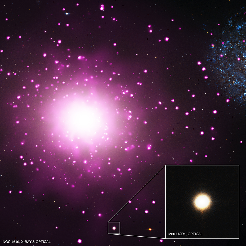
Ultracompact dwarf galaxy M60-UCD1 shines in the inset image based on images from the Hubble Space Telescope and Chandra X-Ray Telescope. Chandra data is pink, and Hubble data is red, green and blue. The large galaxy dominating the field of view is M60. At the right edge is NGC 4647. Credit: X-ray: NASA/CXC/MSU/J.Strader et al, Optical: NASA/STScI
In its weight class, M60-UCD1 is a standout. Last year, Seth was second co-author on a group that announced that it was the densest nearby galaxy, with stars jam-packed 25 times closer than in the Milky Way. It’s also one of the brightest they know of, a fact that is helped by the galaxy’s relative closeness to Earth. It’s roughly 54 million light-years away, as is the massive galaxy it orbits: M60. The two galaxies are only 20,000 light-years apart.
Supermassive black holes are known to lurk in the centers of most larger galaxies, including the Milky Way. How they got there in the first place, however, is unclear. The find inside of M60-UCD1 is especially intriguing given the relative size of the black hole to the galaxy itself. The black hole is about 15% of the galaxy’s mass, with an equivalent mass of 21 million Suns. The Milky Way’s black hole, by contrast, takes up less than a percentage of our galaxy’s mass.
Given so few ultracompact galaxies are known to astronomers, some basic properties are a mystery. For example, the mass of these galaxy types tends to be higher than expected based on their starlight.
Some astronomers suggest it’s because they have more massive stars than other galaxy types, but Seth said measurements of stars within M60-UCD1 (based on their orbital motion) show normal masses. The extra mass instead comes from the black hole, he argues, and that will likely be true of other ultracompact galaxies as well.
A Hubble Space Telescope image of ultracompact galaxy M60-UCD1 (inset), which is suspected to host a supermassive black hole at its center. It is orbiting the nearby massive galaxy M60. Within the same field of view is NGC 4647. Credit: NASA/Space Telescope Science Institute/European Space Agency
“It’s a new place to look for black holes that was previously not recognized,” he said, but acknowledged the idea of black holes existing in similar galaxies will not be widely accepted until the team makes more finds. An alternative explanation to a black hole could be a suite of low-mass stars or neutron stars that do not give off a lot of light, but Seth said the number of these required in M60-UCD1 is “unreasonably high.”
His team plans to look at several other ultracompact galaxies such as M60-UCD1, but perhaps only seven to eight others would be bright enough from Earth to perform these measurements, he said. (Further work would likely require an instrument such as the forthcoming Thirty-Meter Telescope, he said.) Additionally, Seth has research interests in globular clusters — vast collections of stars — and plans a visit to Hawaii next month to search for black holes in these objects as well.
Results were published today (Sept. 17) in the journal Nature.
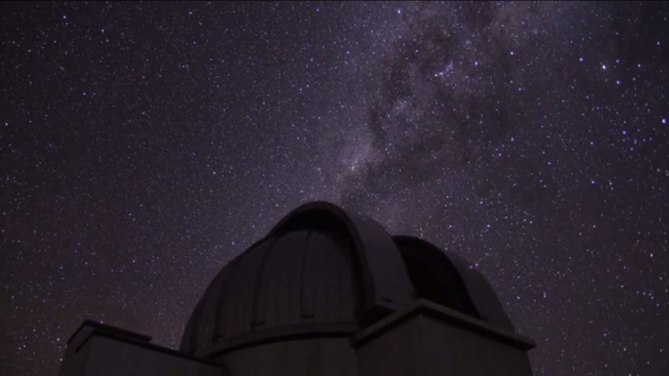
A screenshot from "StarryNights", a video showing several observatories at work. Credit: Jan Hattenbach / Vimeo (screenshot)
We often speak of the discoveries and data flowing from astronomical observatories, which makes it easy to forget the cool factor. Think of it — huge telescopes are probing the universe under crystal-clear skies, because astronomers need the dark skies to get their work done.
That’s what makes this astronomical video by Jan Hattenbach such a treat. He’s spent the past three years catching stunning video shots at observatories all over the world, showing timelapses of the Milky Way galaxy and other celestial objects passing overhead.
“The time-lapses were a byproduct of our visual observing – because obviously, these sites are also the best in the world for visual observing and astrophotography. If you ever have the chance to spend a night at one of these observatories, consider yourself very lucky!” wrote Hattenbach on Vimeo.
And often you don’t even need a telescope to appreciate the beauty of the cosmos. Earlier this summer, we posted another video showing the stunning sky above Desert National Park.
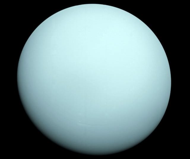
Uranus as seen through the automated eyes of Voyager 2 in 1986. (Credit: NASA/JPL).
It’s no joke… now is the time to begin searching the much-maligned (and mispronounced) planet Uranus as it reaches opposition in early October leading up to a very special celestial event.
Last month, we looked at the challenges of spying the solar system’s outermost ice giant world, Neptune. Currently located in the adjacent constellation Aquarius, Neptune is now 39 degrees from Uranus and widening. The two worlds had a close conjunction of just over one degree of separation in late 1993, and only long time observers of the distant worlds remember a time waaaay back in the early-1970s where the two worlds appeared farther apart than 2014 as seen from our Earthly vantage point.
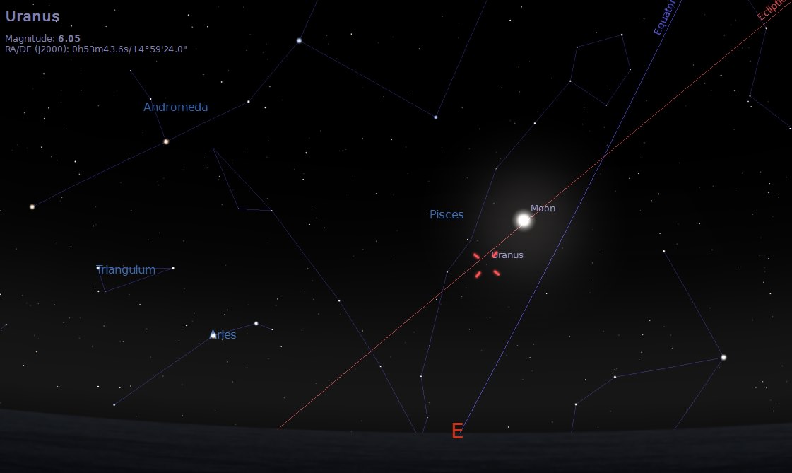
Uranus rising to the east the evening of October 7th, just prior to the start of the October 8th lunar eclipse later the same evening. Created using Stellarium.
In 2014, opposition occurs at 21:00 Universal Time (UT)/5:00 PM EDT on October 7th. If this date sounds familiar, it’s because Full Moon and the second total lunar eclipse of 2014 and the ongoing lunar tetrad of eclipses occurs less than 24 hours afterwards. This puts Uranus extremely close to the eclipsed Moon, and a remote slice of the high Arctic will actually see the Moon occult (pass in front of) Uranus during totality. Such a coincidence is extremely rare: the last time the Moon occulted a naked eye planet during totality occurred back during Shakespearian times in 1591, when Saturn was covered by the eclipsed Moon. This close conjunction as seen from English soil possibly by the bard himself was mentioned in David Levy’s book and doctoral thesis The Sky in Early Modern English Literature, and a similar event involving Saturn occurs in 2344 AD.
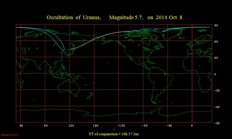
The footprint of the October 8th occultation of Uranus. Credit: Occult 4.1.
We’re also in a cycle of occultations of Uranus in 2014, as the speedy Moon slides in front of the slow moving world every lunation until December 2015. Oppositions of Uranus — actually pronounced “YOOR-un-us” so as not to rhyme with a bodily orifice — currently occur in the month of September and move forward across our calendar by about 4 days a year.
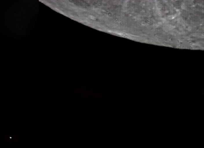
Uranus (lower left) near the limb of the gibbous Moon of September 11th, 2014. Credit: Roger Hutchinson.
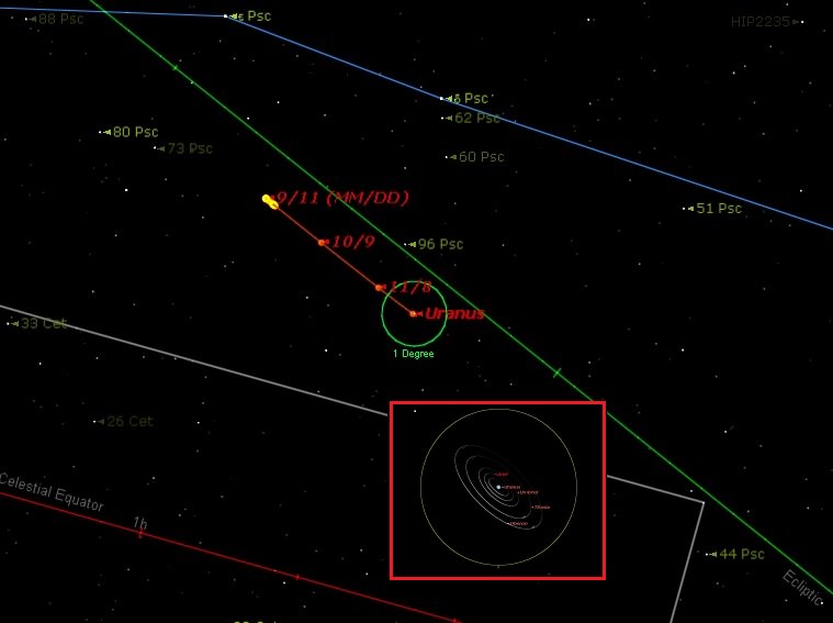
This year sees Uranus in the astronomical constellation Pisces just south of the March equinoctial point. Uranus is moving towards and will pass within a degree of the +5.7 magnitude star 96 Piscium in late October through early November. Shining at magnitude +5.7 through the opposition season, Uranus presents a disk 3.7” in size at the telescope. You can get a positive ID on the planet by patiently sweeping the field of view: Uranus is the tiny blue-green “dot” that, unlike a star, refuses to come into a pinpoint focus.
The apparent path of Uranus from September 2014 through January 2015 across the constellation Pisces. The inset shows the tilt and orbit of its major moons across a 2′ field of view. Created by the author using Starry Night Education software.
Uranus also presents us with one of the key mysteries of the solar system. Namely, what’s up with its 97.8 degree rotational tilt? Clearly, the world sustained a major blow sometime in the solar system’s early history. In 2014, we’re viewing the world at about a 28 degree tilt and widening. This will continue until we’re looking straight at the south pole of Uranus in early 2030s. Of course, “south” and “north” are pretty arbitrary when you’re knocked back over 90 degrees on your axis! And while we enjoy the September Equinox next week on September 23rd, the last equinox for any would-be “Uranians” occurred on December 16th, 2007. This put the orbit of its moons edge-on from our point of view from 2006-2009 for only the third time since discovery of the planet in 1781. This won’t occur again until around 2049. Uranus also passed aphelion in 2009, which means it’s still at the farther end of its 19.1 to 17.3 astronomical unit (A.U.) range from the Sun in its 84 year orbit.
The moons of Uranus and Neptune as imaged during the 2011 opposition season. Credit: Rolf Wahl Olsen, used with permission.
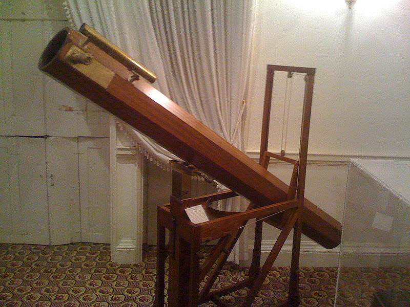
And as often as Uranus ends up as the butt (bad pun) of many a scatological punch line, we can at least be glad that the world didn’t get named Georgium Sidus (Latin for “George’s Star”) after William Herschel’s benefactor, King George the III. Yes, this was a serious proposal (!). Herschel initially thought he’d found a comet upon spying Uranus, until he realized its slow motion implied a large object orbiting far out in the solar system.
A replica of the reflecting telescope that Herschel used to discover Uranus. Credit: Alun Salt/Wikimedia Commons image under a Creative Commons Attribution Share-Alike 2.0 license.
Spurious sightings of Uranus actually crop up on star maps prior to Herschel’s time, and in theory, it hovers juuusst above naked eye visibility near opposition as seen from a dark sky site… can you pick out Uranus without optical assistance during totality next month? Hershel and Lassell also made claims of spotting early ring systems around both Uranus and Neptune, though the true discovery of a tenuous ring system of Uranus was made by the Kuiper Airborne Observatory (a forerunner of SOFIA) during an occultation of a background star in 1977.
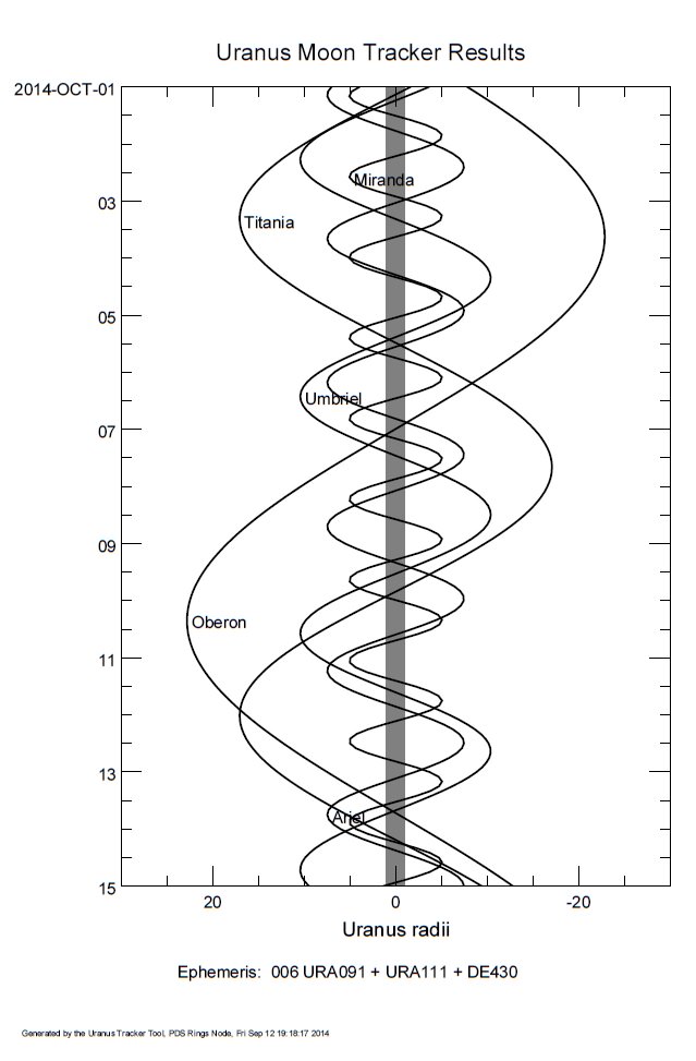
A corkscrew chart for the moons of Uranus through October. Credit: Ed Kotapish/Rings PDS node.
Looking for something more? Owners of large light buckets can capture and even image (see above) 5 of the 27 known moons of Uranus. We charted the orbital elongations for favorable apparitions through October 2014 (to the left). Check out last year’s chart for magnitudes, periods, and maximum separations for each respective moon. An occulting bar eyepiece may help you in your quest to cut down the ‘glare’ of nearby Uranus.
When will we return to Uranus? Thus far, humanity has explored the world up close exactly once, when Voyager 2 passed by in 1986. A possible “Uranus Probe” (perhaps, Uranus Orbiter is a better term) similar to Cassini has been an on- and off- proposal over the years, though it’d be a tough sell in the current era of ever dwindling budgets. Plutonium, a mandatory power source for deep space missions, is also in short supply. Such a mission might take up to a decade to enter orbit around Uranus, and would represent the farthest orbital reconnaissance of a world in our solar system. Speedy New Horizons is just whizzing by Pluto next July.
All great thoughts to ponder as you scour the skies for Uranus in the coming weeks!
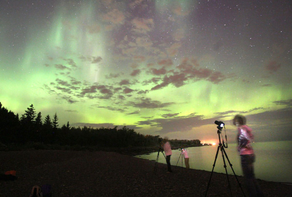
A group of amateur photographers set up on a beach on Lake Superior near Duluth to photograph the northern lights. To shoot the aurora you'll need a tripod and middle to high end digital camera. Pocket cameras work well in daylight and can be used to shoot bright northern lights, but the images will be noisy. Credit: Bob King
Everybody loves pictures of the northern lights! If you’ve never tried to shoot the aurora yourself but always wanted to, here are a few tips to get you started.
“T” stands for a terrific aurora seen last winter near Duluth, Minn. U.S. Photo taken with a high-end digital camera (Canon EOS 1-D Mark III) at ISO 800, 30-second exposure. Credit: Bob King
The strong G3 geomagnetic storm expected tonight should kick out a reasonably bright display, perfect for budding astrophotographers. Assuming the forecasters are correct, you’ll need a few things. A location with a nice open view to the north is a good start. The aurora has several different active zones. There are bright, greenish arcs, which loll about the northern horizon, parallel rays midway up in the northern sky and towering rays and diffuse aurora that can surge past the zenith. Often the aurora hovers low and remains covered by trees or buildings, so find a road or field with good exposure.
15-second time exposure of Vega rising taken with a typical digital pocket camera. Notice the grain or noise throughout. Credit: Bob King
Second, a tripod. You can do so much with this three-legged beast. No better astro tool in the universe. Even the brightest auroras will require a time exposure of at least 5 seconds. Since no human can be expected to hold a camera steady that long, a tripod is a necessity. After that, it comes down to a camera. Most “point-and-shoot” models have limited time exposure ability, often just 15 seconds. That may be long enough for brighter auroras, but to compensate, you’ll have to increase your camera’s sensitivity to light by increasing the “speed” or ISO. The higher you push the ISO, the grainier the images appear especially with smaller cameras. But you’ll be able to get an image, and that may be satisfaction enough.
I use a Canon EOS-1 Mark III camera to shoot day and night. While not the latest model, it does a nice job on auroras. The 16-35mm zoom wide-angle lens is my workhorse as the aurora often covers a substantial amount of sky. My usual routine is to monitor the sky. If I see aurora padding across the sky, I toss the my equipment in the car and drive out to one of several sites with a clear exposure to the north. Once the camera meets tripod, here’s what to do:
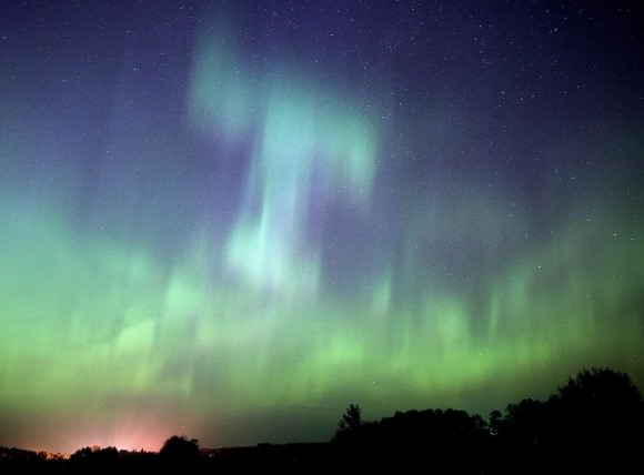
A bright, active aurora. I used my zoom lens at 16mm at f/2.8 and about a 15-second exposure at ISO 800. Credit: Bob King
* Focus: Put the camera in manual mode and make sure my focus is set to infinity. Focusing is critical or the stars will look like blobs and the aurora green mush. There are a couple options. Use autofocus on a cloud or clouds in the daytime or the moon at night. Both are at “infinity” in the camera’s eye. Once focused at infinity, set the camera to manual and leave it there the rest of the evening to shoot the aurora. OR … note where the little infinity symbol (sideways 8) is on your lens barrel and mark it with a thin sharpie so you can return to it anytime. You can also use your camera in Live View mode, the default viewing option for most point-and-shoot cameras where you compose and frame live. Higher-end cameras use a viewfinder but have a Live View option in their menus. Once in Live View, manually focus on a bright star using the back of the camera. On higher-end cameras you can magnify the view by pressing on the “plus” sign. This allows for more precision focus.
* Aperture: Set the lens to its widest open setting, which for my camera is f/2.8. The lower the f-stop number, the more light allowed in and the shorter the exposure. Like having really big pupils! You want to expose the aurora in as short a time as possible because it moves. Longer exposures soften its appearance and blur exciting details like the crispness of the rays.
A friend takes a night sky shot silhouetted against the glow of the northern lights. Credit: Bob King
* ISO speed: Set the ISO to 800 for brighter auroras or 1600 for fainter ones and set the time to 30-seconds. If the aurora is bright and moving quickly, I’ll decrease exposure times to 10-15 seconds. The current crop of high end cameras now have the capacity to shoot at ISOs of 25,000. While those speeds may not give the smoothest images, dialing back to ISO 3200 and 6400 will make for photos that look like they were shot at ISO 400 on older generation cameras. A bright aurora at ISO 3200 can be captured in 5 seconds or less.
* Framing: Compose the scene in the viewfinder or monitor. If you’re lucky or plan well, you can include something interesting in the foreground like a building, a picturesque tree or lake reflection.
* Press!: OK, ready? Now press the button. When the image pops up on the viewing screen, does the image seem faint, too bright or just right. Make exposure adjustments as needed. If you need to expose beyond the typical maximum of 30 seconds, you can hold the shutter button down manually or purchase a cable release to hold it down for you.
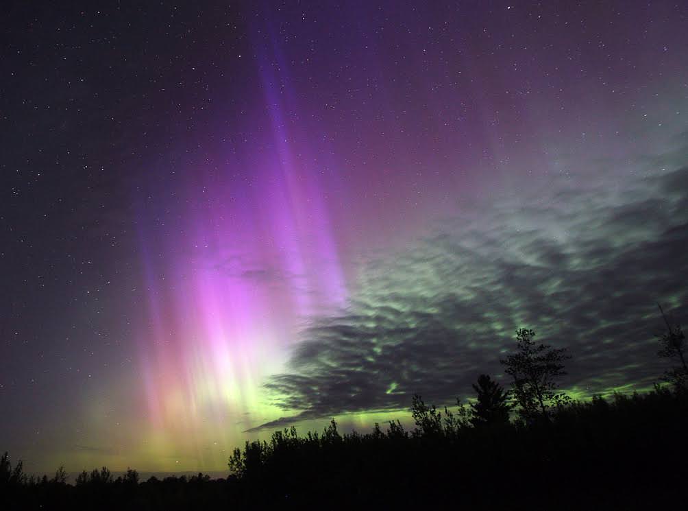
Great example of a well-composed photo with an interesting foreground choice. This intense aurora was shot on September 12, 2014 in central Maine. Credit: Mike Taylor
It’s easy, right? Well then, why did it take me 400 words to explain it??? Of course the magic happens when you look at the monitor. You’ll see these fantastic colorful forms and ask yourself “did I do that?”
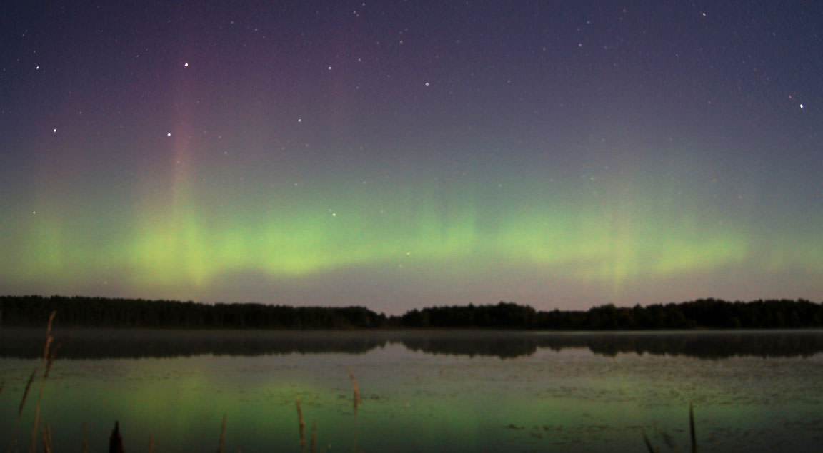
A bright arc and pink-topped rays stipple the northern sky and cross the Bowl of the Big Dipper last night around 11:30 p.m. CDT over Caribou Lake north of Duluth, Minn. Credit: Guy Sander
(Scroll down for latest update)
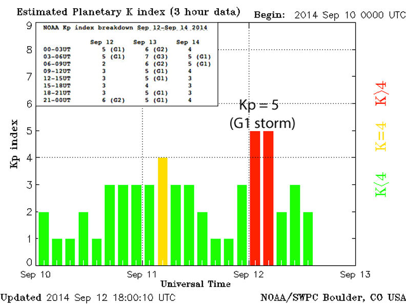
Auroras showed up as forecast last night beginning around nightfall and lasting until about 1 a.m. CDT this morning. Then the action stopped. At peak, the Kp indexdinged the bell at “5” (minor geogmagnetic storm) for about 6 hours as the incoming shock from the arrival of the solar blast rattled Earth’s magnetosphere. It wasn’t a particularly bright aurora and had to compete with moonlight, so many of you may not have seen it. You needn’t worry. A much stronger G3 geomagnetic storm from the second Earth-directed coronal mass ejection (CME) remains in the forecast for tonight.
Plot showing the Kp index of magnetic activity high in the Earth’s magnetic domain called the magnetosphere. The two red bars show the Kp at ‘5’ last night and early this morning (dotted line represents 0 UT or 7 p.m. CDT). Inset is the current detailed forecast in Universal Time (Greenwich Time) in 3-hour increments. Credit: NOAA
Activity should begin right at nightfall and peak between 10 p.m. and 1 a.m. Central Daylight Time. The best place to observe the show is from a location well away from city lights with a good view of the northern sky. Auroras are notoriously fickle, but if the NOAA space forecasting crew is on the money, flickering lights should be visible as far south as Illinois and Kansas. The storm also has the potential to heat and expand the outer limits of Earth’s atmosphere enough to cause additional drag on low-Earth-orbiting (LEO) satellites. High-frequency radio transmissions like shortwave radio may be reduced to static particularly on paths crossing through the polar regions.
Earth’s magnetic bubble, generated by motions within its iron-nickel core and shaped by the solar wind, is called the magnetosphere. It extends some 40,000 miles forward of the planet and more than 3.9 million miles in the tailward direction. Most of the time it sheds particle blasts from the sun called coronal mass ejections, but occasionally one makes it past our defenses and we get an auroral treat. Credit: NASA
If you study the inset box in the illustration above, you can see that from 21-00UT (4 -7 p.m. Central time) the index jumps quickly form “3” to “6” as the blast from that second, stronger X-class flare (September 10) slams into our magnetosphere. Assuming the magnetic field it carries points southward, it should link into our planet’s northward-pointing field and wreak beautiful havoc. A G2 storm continues through 10 p.m. and then elevates to Kp 7 or G3 storm between 10 p.m. and 1 a.m. before subsiding slightly in the wee hours before dawn. The Kp index measures how disturbed Earth’s magnetic field is on a 9-point scale and is compiled every 3 hours by a network of magnetic observatories on the planet.
A lovely rayed arc reflected in Caribou Lake north of Duluth, Minn. on September 11, 2014. Tonight the moon rises around 9:30 p.m. The lower in the sky it is, the brighter the aurora will appear. Hopefully tonight’s lights will outdo what the moon can dish out. Credit: Guy Sander
All the numbers are lined up. Now, will the weather and solar wind cooperate? Stop back this evening as I’ll be updating with news as the storm happens. For tips on taking pictures of the aurora, please see this related story “How to Take Great Pictures of the Northern Lights”.
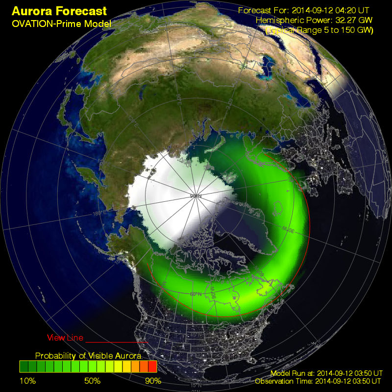
The auroral oval at 11:15 p.m. CDT tonight September 12 shows a temporary pullback into northern Canada. Where the sky is dark, auroras are typically seen anywhere under or along the edge of the oval. Click for current map. Credit: NOAA
* UPDATE 8:15 a.m. Saturday September 13: Well, well, well. Yes, the effects of the solar blast did arrive and we did experience a G3 storm, only the best part happened before nightfall had settled over the U.S. and southern Canada. The peak was also fairly brief. All those arriving protons and electrons connected for a time with Earth’s magnetic field but then disconnected, leaving us with a weak storm for much of the rest of the night. More activity is expected tonight, but the forecast calls for a lesser G1 level geomagnetic storm.
* UPDATE 11 p.m. CDT: After a big surge late this afternoon and early evening, activity has temporarily dropped off. The ACE plot has “gone north” (see below). Though we’re in a lull, the latest NOAA forecast still calls for strong storms overnight.
Definite aurora seen through breaks in the clouds low in the northern sky here in Duluth, Minn. After a big surge late this afternoon and during early evening, activity’s temporarily dropped off. The ACE plot has “gone north”.
* UPDATE 9 p.m. CDT: Aurora a bright greenish glow low in the northern sky from Duluth, Minn.
* UPDATE 7:45 p.m. CDT September 12: Wow! Kp=7 (G3 storm) at the moment. Auroras should be visible now over the far eastern seaboard of Canada including New Brunswick and the Gaspe Peninsula. I suspect that skywatchers in Maine and upstate New York should be seeing something as well. Still dusk here in the Midwest.
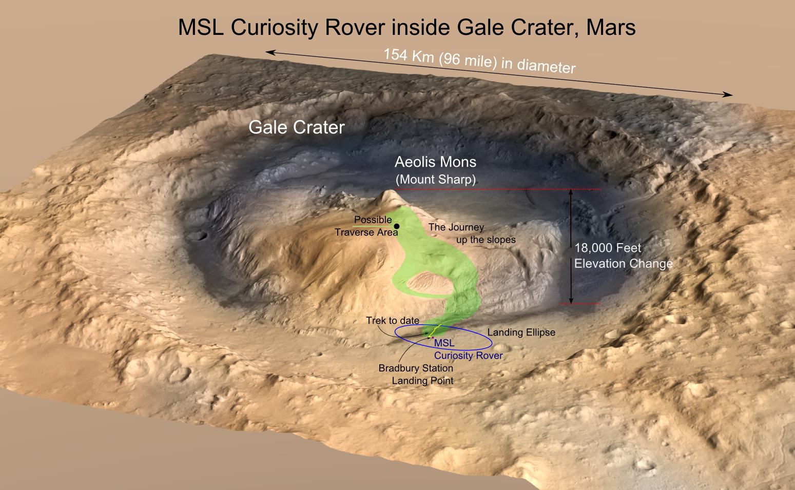
MRO image of Gale Crater illustrating the landing location and trek of the Rover Curiosity. Curiosity's images and data show that the Gale Crater held water for much longer than thought. (Credits: NASA/JPL, illustration, T.Reyes)
Scientists at the Jet Propulsion Laboratory have announced that the Mars Science Lab (MSL), Curiosity Rover, has reached the base of the central peak inside Gale Crater, Aeolis Mons also known as Mount Sharp. Mount Sharp is a prime objective of NASA’s Curiosity journey. The mountain is like a layer cake, holding a chronology of past events, one after the other, stacked upon each other over billions of years. It took two years and one month to reach this present point and what lies ahead is the beginning of an upward trek towards the peak of Mount Sharp, 5500 meters (18,000 feet) above the floor of Gale Crater. However, it is worth a look back and to consider what Mount Sharp represents to the mission.
For over 17 years, NASA robotic spacecraft have maintained a constant presence above or upon the surface of Mars. The Mars Pathfinder mission arrived on July 4, 1997, then quickly followed by Mars Global Surveyor on September 11 and since this time, there has always been at least one active Mars mission.
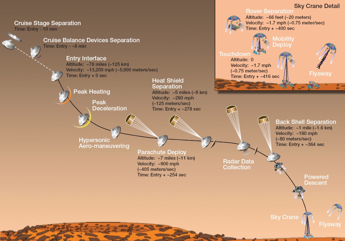
“Seven Minutes of Terror” – the Entry, Descent and Landing (EDL) of the Mars Science Lab (MSL) – Mars Curiosity Rover. (Credit: NASA/JPL)
On November 26, 2011, the voyage of Mars Curiosity Rover began as a trek across 320 million kilometers (200 million miles) of the inner Solar System and culminated in the coined “Seven Minutes of Terror”. For seven long minutes, the MSL, the Mars Curiosity Rover, plowed straight into the Martian atmosphere – the entry, deployed a parachute – the descent, to slow down to about 320 km/hour (200 mph) then the Sky Crane with Rover under foot was released – the landing. With only seconds before an imminent hard impact, the Sky Crane hit the breaks, firing its rockets, then released Curiosity Rover on a tether. This was the Entry, Descent and Landing (EDL). All the while, it was the computer inside the Rover in control. When the tether was cut, the Sky Crane was forced to switch to a simpler processor within its system to complete a final scuttling of itself a few hundred meters away.
The Sky Crane gently lowered Curiosity to the landing point, christened Bradbury Station after the celebrated science fiction writer, Ray Bradbury, writer of the Martian Chronicles(c.1950), who passed away at age 91, 61 days before the landing on August 5, 2012. (recommended video – R. Bradbury reading “If Only We had been Taller” at the public event marking the arrival of Mariner 9 at Mars, November 12, 1971)
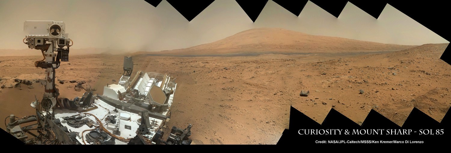
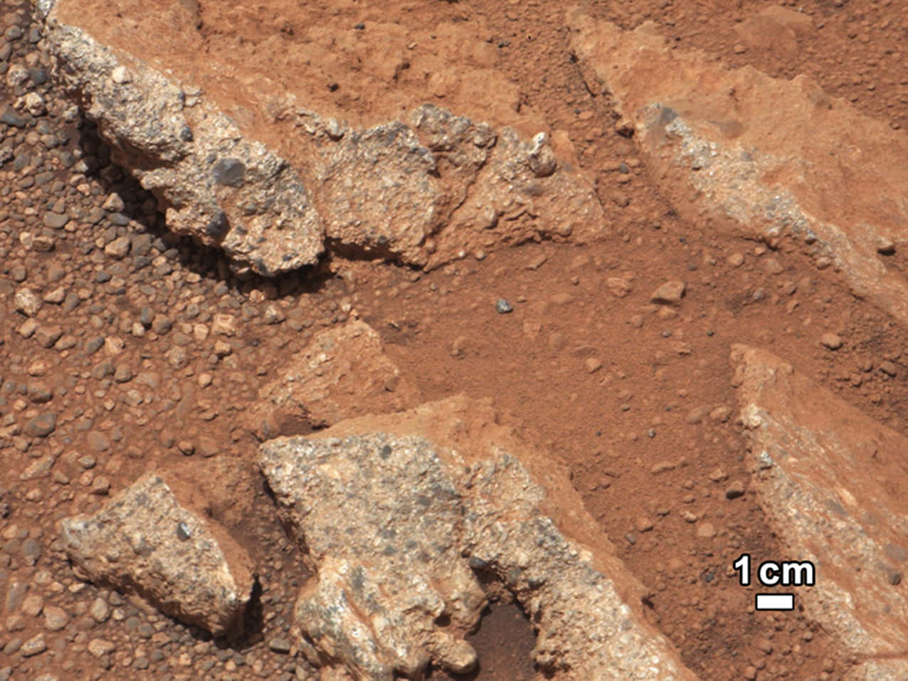
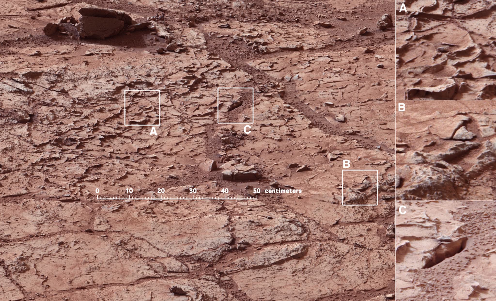
The ultimate Selfie – a self-protrait taken on anoher planet. This is the capability of the Mars Hand Lens Imager (MAHLI) camera, one of 5 instruments on the turret at the end of the 2.1 meter (7 ft), 30 kg (66 lb) Robotic Arm. On numerous occasions, Curiosity has taken self-portraits, many as mosaics. This on is on Sol (Mars day) 85, post landing, showing Curiosity with its destination – Aeolis Mons (Mt. Sharp) in the background. (Credit: NASA/JPL-Caltech/MSSS/Ken Kremer/Marco Di Lorenzo, “Curiosity Celebrates 90 Sols Scooping Mars and Snapping Amazing Self-Portrait with Mount Sharp“)September 27, 2012: A rock outcrop called Link pops out from a Martian surface taken by the 100-millimeter Mast Camera on NASA’s Curiosity Mars rover September 2, 2012. Rounded gravel fragments, or clasts, up to a couple inches (few centimeters) in size are in a matrix of white material. The outcrop characteristics are consistent with a sedimentary conglomerate, or a rock that was formed by the deposition of water and is composed of many smaller rounded rocks cemented together. Scientists enhanced the color in this version to show the Martian scene as it would appear under the lighting conditions we have on Earth, which helps in analyzing the terrain. (NASA/JPL-Caltech/MSSS/Handout/Reuters)Mars Curiosity at the “John Klein” site in Yellow Knife Bay on January 10, 2013 (Mars Sol 153). The Mastcam mosaic was taken from 5 meters (16 ft). The area is full of fractures and veins with intervening rock with concretions (small spherical concentrations of minerals). The enlargements show particular areas of interest. (A) Ridge-like veins protruding from the surface. (B) Shows discontinuities in the veins that likely extend beneath the surface. (C) Shows a hole developed in the sand that overlies a fracture, implying infiltration of sand down into the fracture system. To this author, the area around (A) seems similar to the remnants of dried mud chips or scales one finds in the dry areas of estuaries on Earth. (Credits: NASA/JPL)
What has followed in the last 25 months since the landing is simply staggering. Mars Curiosity Rover, with the most advanced array of instruments and tools ever delivered to a celestial body, has already delivered an immense trove of images and scientific data that is improving and changing our understanding of Mars.
HIRISE images from the orbiting MRO spacecraft are used to show the old and new routes of NASA’s Mars Curiosity rover. The new route provides excellent access to many features in the Murray Formation. And it will eventually pass by the Murray Formation’s namesake, Murray Buttes, previously considered to be the entry point to Mt. Sharp. (Credit: NASA/JPL-Caltech/Univ. of Arizona)
Curiosity had been making progress towards an entry point to Mount Sharp called Murray Buttes, however, because of challenges that the terrain posed – sand dunes and treacherous rocks, they have chosen to enter at Pahrump Hills. Furthermore, the new entry to the lower slopes of Mount Sharp are considered scientifically more interesting. The boundary between the mountain and the crater-floor deposits is not an exact one but NASA scientists explained the reason for the announcement at this point:
“Both entry points lay along a boundary where the southern base layer of the mountain meets crater-floor deposits washed down from the crater’s northern rim.” The terrain is now primarily material from the mountain from here on upward.
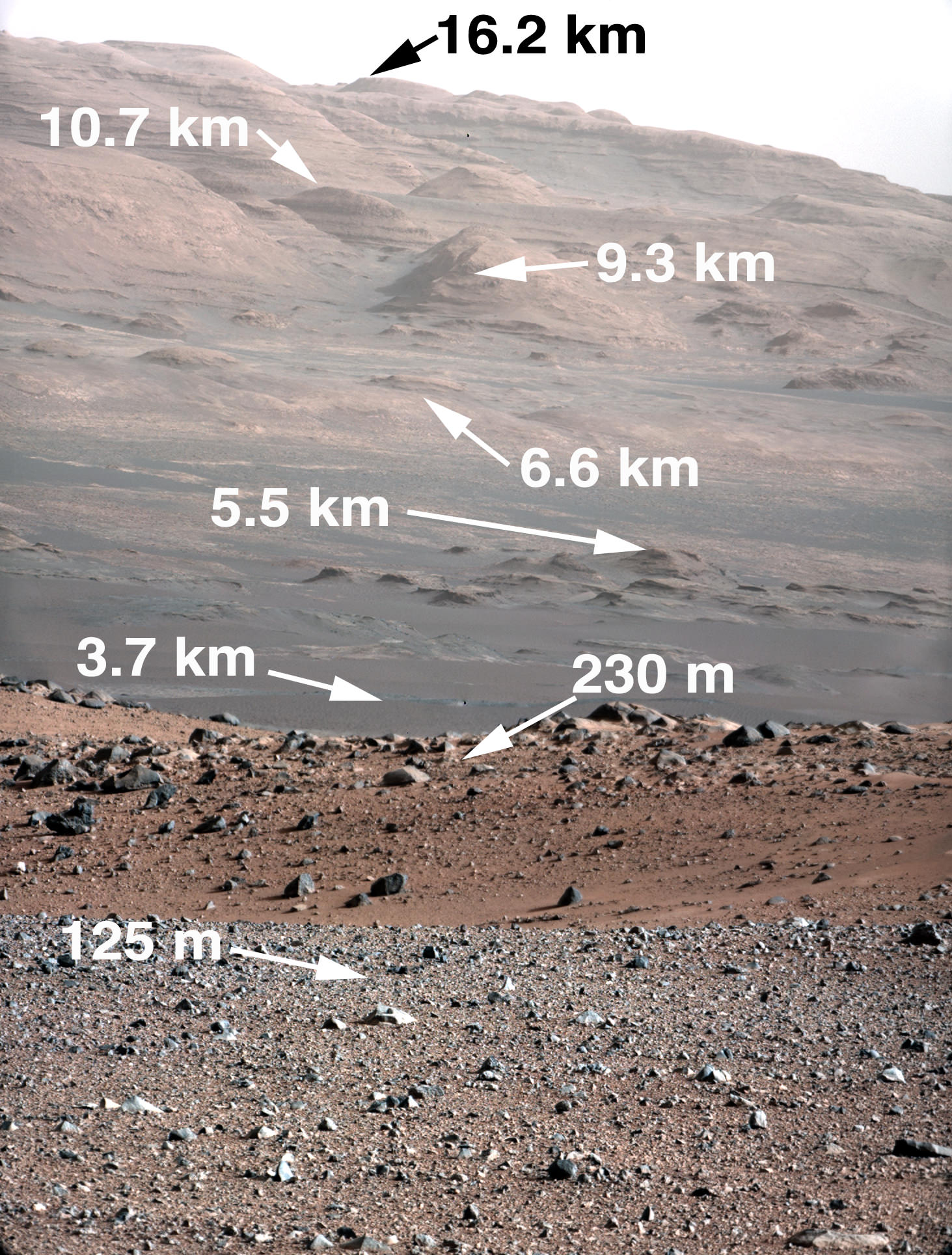
Image taken by the MastCam of Curiosity Rover on August 23, 2012 which shows the buttes representing the base of Mount Sharp, including Murray Buttes. Today, two years later, Mars Curiosity now stands at entry points in the region of the buttes at 6.6 km (direct line distance). In the middle of the image is the boulder-strewn area in which much of Curiosity’s wheel damage occurred. At top are the expansive series of sendiments that is the great interest of Mars researchers. (Credit: NASA/JPL)
Mount Sharp is anything but the normal central peak of an impact crater. Gale crater at 154 km (96 miles) in diameter is what is called a complex crater. Beyond a certain size, depending on the gravity of the planet, craters will have a central peak. It is similar to the spike of water which is thrust upwards when you drop an object into a pool of water. Like the spike of water, an impact, thrusts regolith upwards and it collapses and coalesces into a central peak. However, with Mount Sharp there is something more. If the peak was nothing but a central impact peak, NASA with Mars Curiosity would not be trekking inside Gale Crater.
As data and analysis has accumulated from not just Mars Curiosity Rover but rather from all the active Mars missions, the models and hypotheses describing the structure and morphology on Mars have become more complex. This model and explanation of how Mount Sharp built up over billions of years uses deposition of ice and dust. Click to enlarge and review the five steps to making a layer cake mountain – Mount Sharp. (Credit: Illustration presented by Paul Niles (NASA Johnson Space Center) and Joseph Michalski (Planetary Science Insitute, UK)at the 43rd Lunar and Planetary Science Conference, The Woodlands, Texas)
Mars scientists believe that Gale crater after its creation was completely filled with sedimentary material from a series of huge floods passing over the surrounding terrain or by dust and ice deposits such as happened at the Martian polar caps. The deposition over 2 billion years left a series sedimentary layers that filled the crater.
Following the deposition of the layers, there was a long period of erosion which has finally led to the condition of the crater today. The erosion by some combination of aeolean (wind) forces and water (additional flooding), scooped out the huge crater, re-exposing most of the original depth. However, covering the original central peak are many sedimentary layers of debris. Gale crater’s original central peak actually remains completely hidden and covered by sedimentation. This is what has attracted scientists with Curiosity to the base of Mount Sharp.
The trek of NASA’s Curiosity Rover from Bradbury Station (landing site, Sol 1) up to Martian Sol 743. The announcement that Curiosity had reached the base of Mt. Sharp is Sol 746. On Martian Sol 675, the Rover took its first step beyond its landing ellipse. (Credit: NASA/JPL)
Within the sedimentary layers covering Mount Sharp, there is a sequential record of the events that laid down the layers. Embedded in each of those layers is a record of the environmental conditions on Mars going back over 2 billion years. At the base are the oldest sedimentary layers and as Curiosity climbs the flanks of the mountain, it will step forward in time. The advanced instrumentation residing on and inside Curiosity will be able to analyze each layer for material content and also determine its age. Each layer and its age will reveal information such as how much water was present, whether the water was alkaline or acidic, if there is any organic compounds. The discovery of organic compounds on Mount Sharp could be, well, Earth shaking. There are organic compounds and then there are organic compounds that are linked to life and this search for organics is of very high importance to this mission.
Already, over the two year trek, Curiosity has seen numerous signs of the flow of water and sedimentation. At its first major waypoint, Glenelg, Curiosity stepped into an area called Yellow Knife Bay that showed numerous signs of past water. There were veins of magnesium salt deposits embedded in the soil, sedimentation and even conglomerate rock such as that found in river beds.
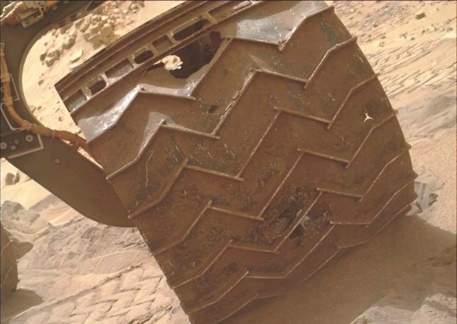
In late 2013, wear and tear accelerated on Curiosity’s wheels, the result of crossing boulder-strewn terrain. Clearly signs of punctures, tears and dents are seen in the photo taken by Curiosity performing a self-inspection. While it certainly raised alarm, mission planners remain confident that it can be handled and will not limit the duration of the mission.(Credits: NASA/JPL)
There is another side to the terrain that Curiosity is traversing. The crater floor, essentially a flood plain has been particularly hard on the mobility system of Curiosity. This is to say that the sharp rocks it continues to encounter under foot are taking a toll on the wheels. Curiosity is now being operated in reverse in order to reduced the impact forces on its wheels.
Furthermore, while scientists are helping to choose the path of the rover, the Curiosity drivers who must assess the field ahead must find paths with fewer sharp rocks in order to slow the damage being done. The Mars Curiosity team is concerned but remain confident that the mobility system will be capable of surviving the ten year life span of the rover’s power supply. So, the momentous occasion is hardly a time to pause and reflect, the trek moves upward, northward to see what the layers on Mount Sharp will reveal.
There are competing hypotheses on how Mount Sharp evolved. Here are two worthy web pages with additional reading.
An example of a telescope logbook waiting to be transcribed. Credit: Smithsonian
An old brick building on Harvard’s Observatory Hill is overflowing with rows of dark green cabinets — each one filled to the brim with hundreds of astronomical glass plates in paper sleeves: old-fashioned photographic negatives of the night sky.
All in all there are more than 500,000 plates preserving roughly a century of information about faint happenings across the celestial sphere. But they’re gathering dust. So the Harvard College Observatory is digitizing its famed collection of glass plates. One by one, each plate is placed on a scanner capable of measuring the position of each tiny speck to within 11 microns. The finished produce will lead to one million gigabytes of data.
But each plate must be linked to a telescope logbook — handwritten entries recording details like the date, time, exposure length, and location in the sky. Now, Harvard is seeking your help to transcribe these logbooks.
The initial project is called Digital Access to a Sky Century at Harvard (DASCH). Although it has been hard at work scanning roughly 400 plates per day, without the logbook entries to accompany each digitized plate, information about the brightness and position of each object would be lost. Whereas with that information it will be possible to see a 100-year light curve of any bright object within 15 degrees of the north galactic pole.
The century of data allows astronomers to detect slow variations over decades, something otherwise impossible in today’s recent digital era.
Assistant Curator David Sliski is especially excited about the potential overlap in our hunt for exoplanets. “It covers the Kepler field beautifully,” Sliski told Universe Today. It should also be completed by the time next-generation exoplanet missions (such as TESS, PLATO, and Kepler 2) come online — allowing astronomers to look for long-term variability in a host star that may potentially affect an exoplanet’s habitability.
There are more than 100 logbooks containing about 100,000 pages of text. Volunteers will type in a few numbers per line of text onto web-based forms. It’s a task impossible for any scanner since optical character recognition doesn’t work on these hand-written entries.
Harvard is partnering with the Smithsonian Transcription Center to recruit digital volunteers. The two will then be able to bring the historic documents to a new, global audience via the web. To participate in this new initiative, visit Smithsonian’s transcription site here.
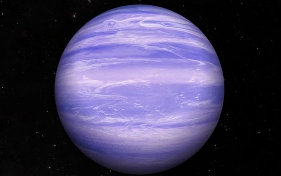
Artist's conception of brown dwarf WISE J085510.83-071442.5, which may host water ice clouds in its atmosphere. Credit: Rob Gizis (CUNY BMCC / YouTube (screenshot)
What are planetary atmospheres made of? Figuring out the answer to that question is a big step on the road to learning about habitability, assuming that life tends to flourish in atmospheres like our own.
While there is a debate about how indicative the presence of, say, oxygen or water is of life on Earth-like planets, astronomers do agree more study is required to learn about the atmospheres of planets beyond our solar system.
Which is why this latest find is so exciting — one astronomy team says it may have spotted water ice clouds in a brown dwarf (an object between the size of a planet and a star) that is relatively close to our solar system. The find is tentative and also in an object that likely does not host life, but it’s hoped that telescopes may get better at examining atmospheres in the future.
The object is called WISE J085510.83-071442.5, or W0855 for short. It’s the coldest brown dwarf ever detected, with an average temperature between 225 degrees Kelvin (-55 Fahrenheit, or -48 Celsius) and 265 Kelvin (17 Fahrenheit, or -8 Celsius.) It’s believed to be about three to 10 times the mass of Jupiter.
Astronomers looked at W0855 with an infrared mosaic imager on the 6.5-meter Magellan Baade telescope, which is located at Las Campanas Observatory in Chile. The team obtained 151 images across three nights in May 2014.
Astronomers plotted the brown dwarf on a color-magnitude chart, which is a variant of famous Hertzsprung-Russell diagram used to learn more about stars by comparing their absolute magnitude against their spectral types. “Color-Magnitude diagrams are a tool for investigating atmospheric properties of the brown dwarf population as well as testing model predictions,” the authors wrote in their paper.
Based on previous work on brown dwarf atmospheres, the team plotted W0855 and modelled it, discovering it fell into a range that made water ice clouds possible. It should be noted here that water ice is known to exist in all four gas giants of our own Solar System: Jupiter, Saturn, Uranus, and Neptune.
“Non-equilibrium chemistry or non-solar metallicity may change predictions,” the authors cautioned in their paper. “However, using currently available model approaches, this is the first candidate outside our own solar system to have direct evidence for water clouds.”
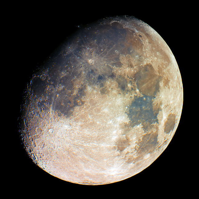
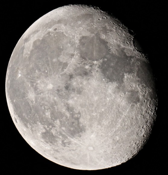
The gibbous moon shines on Sept. 5, 2014. Credit: Christian Kamber
While the SuperMoon of earlier this week got a lot of attention — and rightly so, given the Moon was closest in its orbit to Earth when it was full — the waning and waxing phases around our celestial neighbor are also beautiful. Haunting, in fact.
These shots were taken by members of our Universe Today Flickr pool, with the moon either entering or exiting the full moon phase. Got some stunning astronomy shots to share? Feel free to add your contributions to the group (which says you will give us permission to publish) and we may include them in a future story.
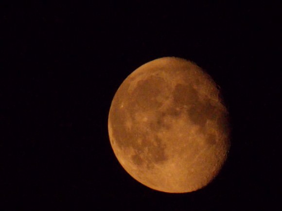
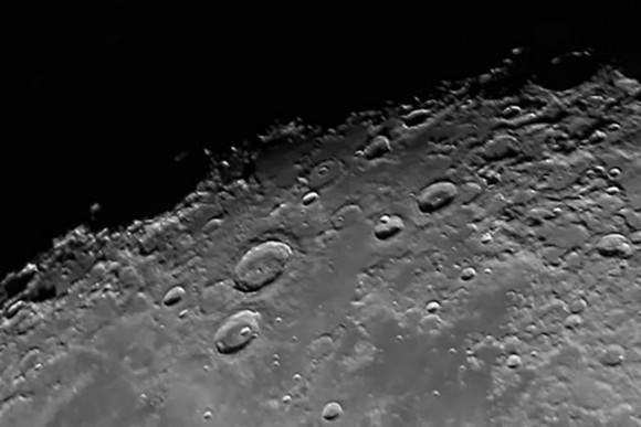
The moon in its waning gibbous phase on Sept. 12, 2014. Photo taken with a Canon 700D attached to a Maksutov 127mm telescope. Credit: Sarah&Simon FisherThe moon shines red in this photo taken from Newcastle upon Tyne, England on Sept. 11, 2014. Credit: David BlanchflowerThe large craters Atlas (left) and Hercules (below) on the moon. Taken using a Canon 1100D. Credit: Paul M. Hutchinson
EDIT: We just received a nice sequence of shots from Laura Austin:
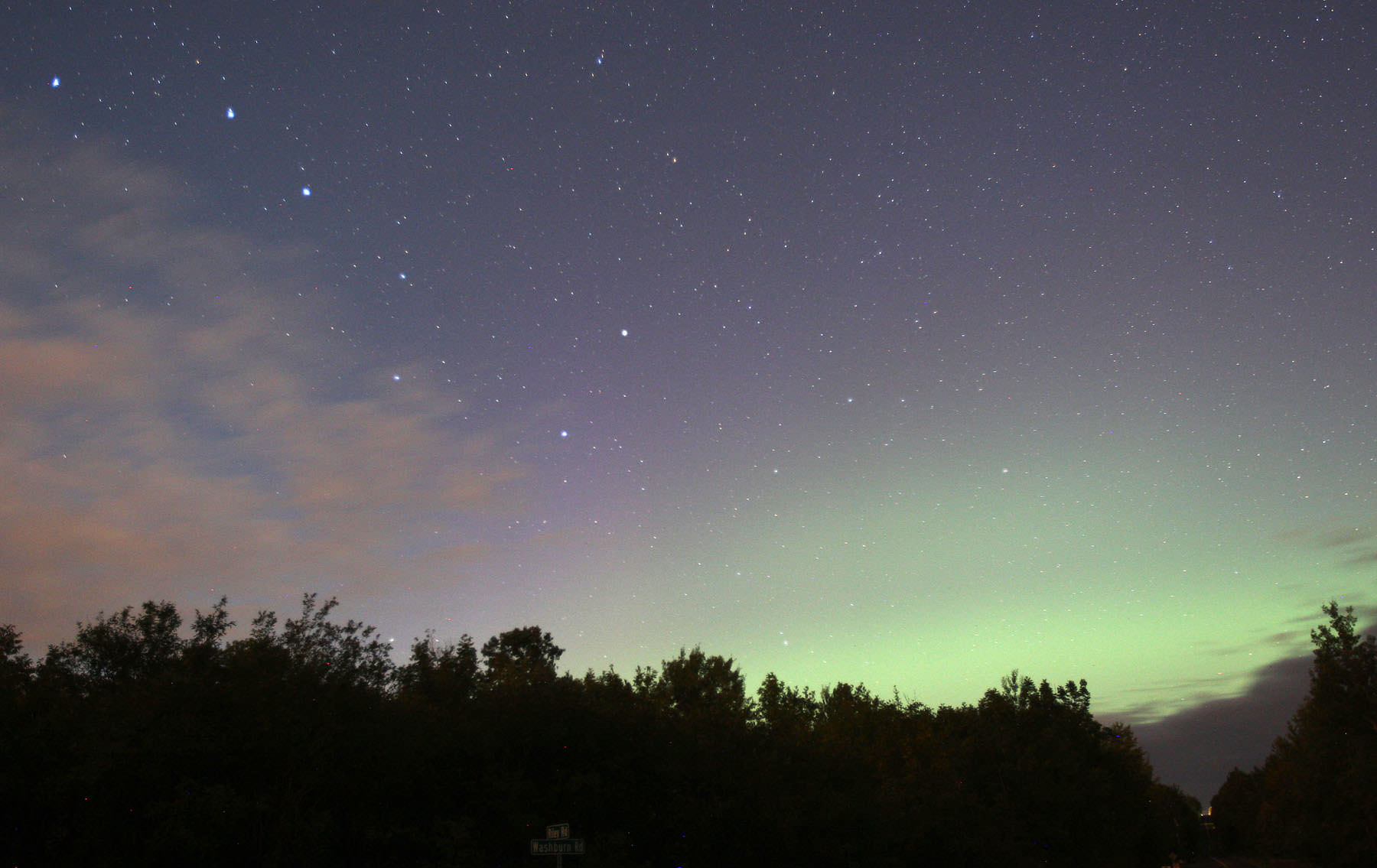
A low arc, glowing green from excited oxygen, spans the northern sky around 10:30 p.m Central Daylight Time from Duluth, Minn. The Big Dipper is off to the left. Credit: Bob King
Talk of aurora is in the air. Our earlier storytoday by Elizabeth Howell alerted you to the possibility of northern lights. Well, it’s showtime! As of 9:30 p.m. Central Daylight Time, the aurora has been active low in the northern sky.
Subtle pink rays stand above the green arc at 9:35 p.m. CDT. Credit: Bob King
From Duluth, Minn. U.S., a classic green arc low in the northern sky competed with the light of the rising gibbous moon. Once my eyes were dark-adapted, faint parallel rays stood streaked the sky above the arc. NOAA space weather forecasters expect this storm to peak between 1 a.m. CDT and sunrise Friday morning September 12 at a G2or moderate level. Skywatchers across the northern tier of states and southern Canada should see activity across the northern sky. Moonlight will compromise the show, but it rises later each night and dims through the weekend.
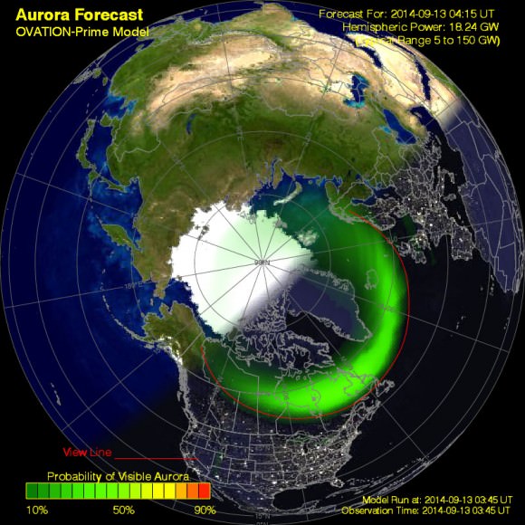
The approximate extent of the auroral oval forecast for 11:30 p.m. CDT from Ovation. Credit: NOAA
This is only the start. Things really kick into gear Friday night and Saturday morning when a G3 strong geomagnetic storm is expected from the more direct blast sent our way by the September 10 X1.6 flare. Auroras might be visible as far south as Illinois and Kansas.
We’ll keep you in touch with storm activity by posting regular updates over the next couple days. Including odd hours. Here are some links to check during the night as you wait for the aurora to put in an appearance at your house:
* Ovation oval – shows the approximate extent of the auroral oval that looks like a cap centered on Earth’s geomagnetic pole. During storms, the oval extends south into the northern U.S. and farther.
* Kp index – indicator of magnetic activity high overhead and updated every three hours. A Kp index of “5” means the onset of a minor storm; a Kp of “6”, a moderate storm.
* NOAA space weather forecast
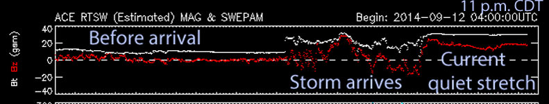
* Advanced Composition Explorer (ACE) satellite plots – The magnetic field direction of the arriving wind from the sun. The topmost graph, plotting Bz, is your friend. When the curve drops into the negative zone that’s good! A prolonged stay at -10 or lower increases the chance of seeing the aurora. Negative numbers indicate a south-pointing magnetic field, which has a greater chance of linking into Earth’s northward-pointing field and wriggling its way past our magnetic defenses and sparking auroras.