How Long is a Day on Jupiter

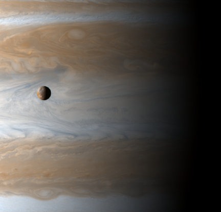
Jupiter and moon Io (NASA)

The Universe Today readers are always asking great questions. ”How long is a day on Jupiter?”, is one of them. A day on Jupiter, also known as the sidereal rotation period, lasts 9.92496 hours. Jupiter is the fastest rotating body in our Solar System. Determining the length of a day on Jupiter was very difficult, because, unlike the terrestrial planets, it does not have surface features that scientists could use to determine its rotational speed.

Scientists cast about for ways to judge the planet’s rotational speed. An early attempt was to do some storm watching. Jupiter is constantly buffeted by atmospheric storms, so the theory was that you could locate the center of a storm and get some idea of the length of a day. The problem scientists encountered was that the storms on Jupiter are very fast moving, making them an inaccurate source of rotational information. Scientist were finally able to use radio emissions from Jupiter’s magnetic field to calculate the planet’s rotational period and speed. While other parts of the planet rotate at different speeds, the speed as measured by the magnetosphere is used as the official rotational speed and period.

All of the planets are oblate spheroids with varying degrees of flattening. Jupiter’s extremely fast rotation flattens it more than any other planet. The diameter of the equator is 9275 km more than the distance from pole to pole. Another interesting effect of Jupiter’s rotational speed is that, because Jupiter is not a solid body, its upper atmosphere features differential rotation. The atmosphere above the poles rotates about five minutes slower than the atmosphere at the equator.

Jupiter is almost a solar system unto itself. Many astronomers believe the the planet is simply a failed star, just lacking the mass needed to ignite fusion. Many people are aware of its four largest moons, the Galilean moons Io, Europa, Ganymede, and Callisto, but few realize that Jupiter has 50 confirmed moons and at least 14 provisional moons. The four largest moons are all very interesting to scientists. Io is a volcanic nightmare. Europa is covered in water ice and may have oceans of slushy ice underneath. Ganymede is the largest moon in the Solar System, even bigger than Mercury, and is the only moon known to have an internally generated magnetic field like Earth’s. Callisto is interesting because its surface is thought to be very ancient; perhaps original material from the birth of the Solar System.

Knowing ”how long is a day on Jupiter” just scratches the surface of the intrigue that is the Jovian system. You could spend months researching the planet and its moons, yet have more to research to do.

Here’s an article on Universe Today that shows how Jupiter can be very flattened, and an article about how the powerful windstorms are generated from its rotation.

NASA’s Ask an Astronomer also has an answer for the question, “how long is a day on Jupiter?” And a cool video of Jupiter’s rotation.

We’ve also recorded an entire show just on Jupiter for Astronomy Cast. Listen to it here, Episode 56: Jupiter, and Episode 57: Jupiter’s Moons.

Sources:
NASA
Caltech Cool Cosmos

What is the Diameter of Earth?

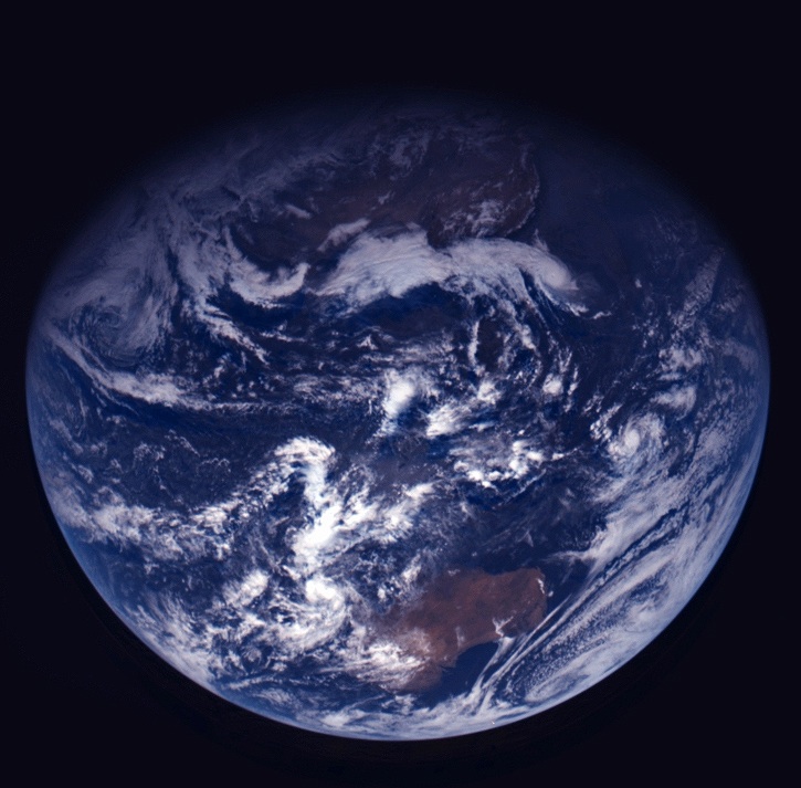
Our beautiful, precious, life-supporting Earth as seen on July 6, 2015 from a distance of one million miles by a NASA scientific camera aboard the Deep Space Climate Observatory spacecraft. Credits: NASA

For those people who have had the privilege of jet-setting or traveling the globe, its pretty obvious that the world is a pretty big place. When you consider how long it took for human beings to settle every corner of it (~85,000 years, give or take a decade) and how long it took us to explored and map it all out, terms like “small world” cease to have any meaning.

But to complicate matters a little, the diameter of Earth – i.e. how big it is from one end to the other – varies depending on where you are measuring from. Since the Earth is not a perfect sphere, it has a different diameter when measured around the equator than it does when measured from the poles. So what is the Earth’s diameter, measured one way and then the other?

Oblate Spheroid:

Thanks to improvements made in the field of astronomy by the 17th and 18th centuries  – as well as geodesy, a branch of mathematics dealing with the measurement of the Earth – scientists have learned that the Earth is not a perfect sphere. In truth, it is what is known as an “oblate spheroid”, which is a sphere that experiences flattening at the poles.

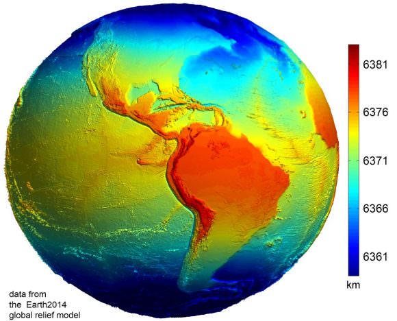
Data from the Earth2014 global relief model, with distances in distance from the geocentre denoted by color. Credit: Geodesy2000

According to the 2004 Working Group of the International Earth Rotation and Reference Systems Service (IERS), Earth experiences a flattening of 0.0033528 at the poles. This flattening is due to Earth’s rotational velocity – a rapid 1,674.4 km/h (1,040.4 mph) – which causes the planet to bulge at the equator.

Equatorial vs Polar Diameter:

Because of this, the diameter of the Earth at the equator is about 43 kilometers (27 mi) larger than the pole-to-pole diameter. As a result, the latest measurements indicate that the Earth has an equatorial diameter of 12,756 km (7926 mi), and a polar diameter of 12713.6 km (7899.86 mi).

In short, objects located along the equator are about 21 km further away from the center of the Earth (geocenter) than objects located at the poles. Naturally, there are some deviations in the local topography where objects located away from the equator are closer or father away from the center of the Earth than others in the same region.

The most notable exceptions are the Mariana Trench – the deepest place on Earth, at 10,911 m (35,797 ft) below local sea level – and Mt. Everest, which is 8,848 meters (29,029 ft) above local sea level. However, these two geological features represent a very minor variation when compared to Earth’s overall shape – 0.17% and 0.14% respectively.

Meanwhile, the highest point on Earth is Mt. Chiborazo. The peak of this mountain reaches an attitude of 6,263.47 meters (20,549.54 ft) above sea level. But because it is located just 1° and 28 minutes south of the equator (at the highest point of the planet’s bulge), it receives a natural boost of about 21 km.

Mean Diameter:

Because of the discrepancy between Earth’s polar and equatorial diameter, astronomers and scientists often employ averages. This is what is known as its “mean diameter”, which in Earth’s case is the sum of its polar and equatorial diameters, which is then divided in half. From this, we get a mean diameter of 12,742 km (7917.5 mi).

The difference in Earth’s diameter has often been important when it comes to planning space launches, the orbits of satellites, and when circumnavigating the globe. Given that it takes less time to pass over the Arctic or Antarctica than it does to swing around the equator, sometimes this is the preferred path.

We have written many interesting articles about the Earth and mountains here at Universe Today. Here’s Planet Earth, The Rotation of the Earth, What is the Highest Point on Earth?, and Mountains: How Are They Formed?

Here’s how the diameter of the Earth was first measured, thousands of years ago. And here’s NASA’s Earth Observatory.

We did an episode of Astronomy Cast just on the Earth. Give it a listen, Episode 51: Earth.

Sources:

How Long is a Year on Earth?

The eccentricity in Mars' orbit means that it is . Credit: NASA

A year on Earth is obviously 1 year long, since it’s the standard of measurement. But we can break it down further.

A year is 365.24 days. Or 8,765 hours, or 526,000 minutes, or 31.6 million seconds.

The tricky one is the number of days. Because the earth year doesn’t work out to exactly 365 days, we have the leap year. If we didn’t, days in the calendar wouldn’t match up with the position of the Earth in its orbit. Eventually, the months would flip around, and the northern hemisphere would have summer in January, and vice versa.

To fix this, we put on extra days in some years, called leap years. In those leap years, a year lasts 366 days, and not the usual 365. This gets tacked onto the end of February. Normally, February only has 28 days, but in leap years, it has 29 days.

When to you have leap years? It’s actually pretty complicated.

The basic rule is that you have a leap year if you can divide the year by 4. So 2004, 2008, etc. But years divisible by 100 are not leap years. So 1800, 1900 aren’t leap years. Unless they’re divisible by 400. So 1600 and 2000 are leap years. By following this algorithm, you can have an Earth orbit that lasts 365.24 days.

With the current system, it’s not actually perfect. There’s an extra 0.000125 days being accumulated. Over course of 8,000 years, the calendar will lose a single day.

Here’s an article about how astronomers might use cosmic rays to measure time on Earth.

And here is more information on how to calculate leap years from timeanddate.com.

We did an episode of Astronomy Cast just on the Earth. Give it a listen, Episode 51: Earth.

Wilkins Ice Shelf Continues Break-up, Even During Winter

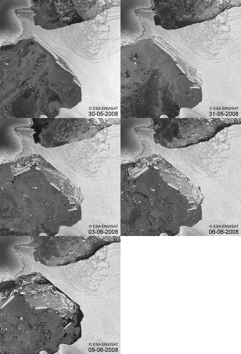
Satellite images reveal the Wilkins Ice Shelf in Antarctica has experienced further break-up with an area of about 160 square kilometers breaking off during May 30 -31, 2008. ESA’s Envisat satellite captured the event. This is the first ever-documented episode to occur during the Antarctic winter. The animation here, comprised of images acquired by Envisat’s Advanced Synthetic Aperture Radar (ASAR) between May 30 and June 9, highlights the rapidly dwindling strip of ice that is protecting thousands of kilometers of the ice shelf from further break-up.

Wilkins Ice Shelf, a broad plate of floating ice south of South America on the Antarctic Peninsula, is connected to two islands, Charcot and Latady. In February 2008, an area of about 400 square km broke off from the ice shelf, narrowing the connection down to a 6 km strip; this latest event in May has further reduced the strip to just 2.7 km.

According to Dr. Matthias Braun from the Center for Remote Sensing of Land Surfaces, Bonn University, and Dr. Angelika Humbert from the Institute of Geophysics, Münster University, who have been investigating the dynamics of Wilkins Ice Shelf for months, this break-up has not yet finished.

“The remaining plate has an arched fracture at its narrowest position, making it very likely that the connection will break completely in the coming days,” Braun and Humbert said.
Long-term satellite monitoring over Antarctica is important because it provides authoritative evidence of trends and allows scientists to make predictions. Ice shelves on the Antarctic Peninsula are important indicators for on-going climate change because they are sandwiched by extraordinarily raising surface air temperatures and a warming ocean.

The Antarctic Peninsula has experienced extraordinary warming in the past 50 years of 2.5°C, Braun and Humbert explained. In the past 20 years, seven ice shelves along the peninsula have retreated or disintegrated, including the most spectacular break-up of the Larsen B Ice Shelf in 2002, which Envisat captured within days of its launch.

News Source: ESA

What is the Driest Place on Earth?

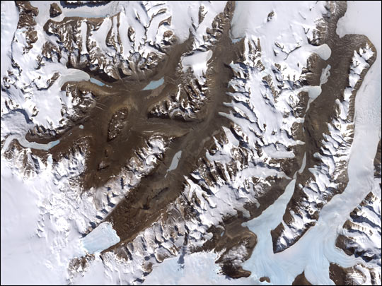
Dry Valleys. Image credit: NASA

The driest place on Earth is in Antarctica in an area called the Dry Valleys, which have seen no rain for nearly 2 million years. There is absolutely no precipitation in this region and it makes up a 4800 square kilometer region of almost no water, ice or snow. Water features include Lake Vida, Lake Vanda, Lake Bonney and the Onyx River. There is no net gain of water. The reason why this region receives no rain is due to Katabatic winds, winds from the mountains that are so heavy with moisture that gravity pulls them down and away from the Valleys.

One feature of note is Lake Bonney, a saline lake situated in the Dry Valleys. It is permanently covered with 3 to 5 meters of ice. Scientists have found mummified bodies of seals around the lake. Lake Vanda, also in the region, is 3 times saltier than the ocean. Temperatures at the bottom of this lake are as warm as 25 degrees Celsius.

The next driest place in the world measured by the amount of precipitation that falls is the Atacama Desert in Chile and Peru. There are no glaciers that are feeding water to this area; and thus, very little life can survive. Some weather stations in this region have received no rain for years, while another station reports an average of one millimeter per year.

Lowest Point on Earth

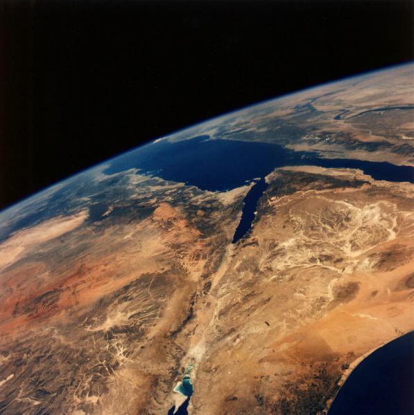
The Dead Sea from space. Image credit: NASA

The lowest point on land is the Dead Sea that borders Israel, the West Bank and Jordan. It’s 420 meters below sea level.

The Dead Sea sits on top of the Dead Sea Rift, a tectonic fault line between the Arabian and the African plates. The movement of these plates causes the Dead Sea to sink about one meter per year! The Dead Sea used to be connected to the Mediterranean Ocean, but over a geologic time scale, it became cut off and evaporation concentrated the salt in the water so that today, the Dead Sea is 30 to 31 percent mineral salts. It has the highest level of salinity of any body of water in the world. Just a side note, I’ve had a chance to swim in the dead sea, and it’s one of the strangest experiences I’ve ever had.

The lowest point on land in the Western Hemisphere is Death Valley in California at 86 meters below sea level.

The lowest point on the Earth’s crust is the Mariana’s Trench in the North Pacific Ocean. It is 11 kilometers deep. Like many of Earth’s extremes, the Mariana’s Trench is caused by the Pacific tectonic plate subducting beneath the Philippine plate; this means that the Pacific Plate is sliding underneath the Philippine plate. The point where the Philippine plate overlaps is Mariana’s Trench.

Could Humans Move the Earth?

When people learn that energy output from the Sun is increasing, and will boil away the planet’s oceans within a billion years, they wonder if there’s any way to stop the process. Obviously, we can’t stop the Sun from shining and increasing its energy output. But is there a way humans could move the Earth further away from the Sun?

The answer is yes. Well, it’s theoretically possible. Not with today’s technology, and not without an enormous amount of energy, but the laws of physics say it’s possible. In fact, nature does it all the time.

The trick is to replicate a natural process called a 3-body interaction. This is what happens when you have nice orbit perturbed by a 3rd object. In this case, we’ve got the Earth nicely orbiting the Sun. But if we could have an asteroid pass by the Earth in just the right way, its gravity would pull our planet out of its orbit just a tiny bit.

Instead of its current elliptical orbit, the Earth would start to spiral outward from the Sun, slowly drifting further and further away. This is very similar to how the Moon is slowly drifting away from the Earth.

If you timed things right, and used several asteroid passes, you could make the Earth spiral outward as the Sun’s energy output is increasing. Instead of getting roasted, we would slowly drift away from the Sun, matching the expanding habitable zone. This would give life on Earth billions more years, instead of a few hundred million.

Of course, playing pool with asteroids is a dangerous game. Give an asteroid the wrong trajectory and it could crash into our planet and end humanity in an instant. And if you get the calculations wrong, you could end up spiraling the Earth away from the Sun too quickly, and freeze the planet. You’ve got to get it just right.

How Far Down is the Center of the Earth?

Cut away of planet Earth

Everyone has wanted to dig a hole down to the center of the Earth at some time in their lives. I think I was in the 3rd grade, and my friends and I tried to dig down as far as we could go. I never told them my goal, but in my heart, we were going all the way through. In the end we actually got down about 2 meters, but the bottom kept filling in with water.

Of course, digging down to the centre of the Earth was always out of reach.

In order to be able to dig down to the center of the Earth, my friends and I would have needed to dig our way through 6,378 km of rock, mantle, and iron. Most of this journey would be through temperatures hot enough to melt rock, getting as high as 7,000 Kelvin at the center.

The first 35 km or so of digging would be through the outer crust of the Earth. Assuming we could actually get through the solid rock, and keep water from filling back into our super deep hole, we might actually be able to make some progress through this.

Temperatures rise as you get deeper, though. One of the deepest mines in the world is the TauTona gold mine in South Africa, a mere 3.6 kilometers deep. Even though this just scratches the surface of the Earth, temperatures at the bottom of TauTona already get as high as 55°C.

Once you break through the crust, you’re into the Earth’s mantle. At this point, you’re looking at about 3,000 km of rock heated to such a high temperature that it’s a liquid. Volcanoes are points on the Earth when magma from the mantle breaks through to the surface.

How we’d dig through that… I have no idea. But let’s say we could.

Then we’d break through into the core of Earth. This region extends for another 3,500 km or so, and its comprised almost entirely of iron, with a little nickel, and some other trace metals. And it’s even hotter than the mantle above it. This is where temperatures get to 7,000 Kelvin. Assuming we could bore through the iron, and could withstand the heat, we could get down to the center of the Earth.

At this point, we would have traveled 6,378 km to complete our journey. And then another 6,378 km to get through the other side and visit the folks in China.

Sources:
http://en.wikipedia.org/wiki/Earth_radius
http://en.wikipedia.org/wiki/TauTona_Mine
http://en.wikipedia.org/wiki/Mantle_%28geology%29

Weekend SkyWatcher’s Forecast – June 13-16, 2008

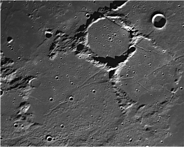
Fra Mauro by Wes Higgins

Greetings, fellow SkyWatchers! It’s big… It’s bright… It’s the Moon! The greatest night sky light polluter is back on the scene, but that doesn’t mean we can’t have a great time as we use telescopes or binoculars to explore the Apollo 14 mission landing site. We’ll continue to visit the lunar surface this weekend, as well as take a look at double stars and two arriving meteor showers. Sky to bright to see meteors? Then let’s try something new….

Friday, June 13 – Today in 1983, Pioneer 10 became the first man made object to leave the solar system. What wonders would it see? Are there other galaxies out there like our own? Will there be life like ours? While we can’t see through Pioneer’s “eyes,” tonight let’s take an historic journey to the Moon, as we look at the northeast shore of Mare Cognitum and the Apollo 14 mission landing site – Fra Mauro.

As craters go, 3.9 billion year old Fra Mauro is on the shallow side and spans 95 kilometers. At some 730 meters deep, standing at the foot of one of its walls would be like standing at the bottom of the Grand Canyon… Yet, time has so eroded this crater that its west wall is completely missing and its floor is covered with fissures.
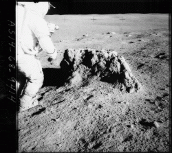
NASAEven though ruined Fra Mauro seems like a forbidding place to land a manned mission, it remained high on the priority list because it is geologically rich. Ill-fated Apollo 13 was to land in a formation north of the crater which was formed by ejecta belonging to the Imbrium Basin – material which had already been mapped telescopically. By returning samples of this material from deep within the Moon’s crust, scientists would have been able to determine the exact time these changes came about.

As you view Fra Mauro tonight, picture yourself in a lunar rover traversing this barren landscape and viewing the rocks thrown out from a long-ago impact. How willing would you be to take on the vision of others and travel to another world?

Saturday, June 14 – As the day begins and you wait on dawn, keep watch for the peak of the Ophiuchid meteor shower with its radiant near Scorpius. The fall rate is poor with only three per hour, but fast moving bolides are common. Today is about the midpoint – and the activity peak – of this 25 day long stream.

Too moony to see anything? Then try an experiment both Ian and I have been working on. When a meteoroid enters our atmosphere, it has an impact on the ionosphere. Take a few moments and download Google Ionosphere and watch what happens as the meteor shower progresses! And don’t forget the “radio” either… Simply tune any FM radio to the lowest frequency that doesn’t receive a clear signal and listen. These ionospheric disturbances will sound like snatches of radio signal, hisses, pops and more. It’s a great way to catch a meteor shower with more than just your eyes!
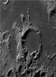
Wes HigginsTonight let’s venture toward the south shore of Palus Epidemiarum to have a high power look at crater Capuanus. Named for Italian astronomer Francesco Capuano di Manfredonia, this 60 kilometer wide crater boasts a still-tall southwest wall, but the northeast one was destroyed by lava flow. At its highest, it reaches around 1900 meters above the lunar surface, yet drops to no more than 300 meters at the lowest. Look for several strikes along the crater walls as well as more evidence of a strong geological history. To its north is the Hesiodus Rima…a huge fault line extending 300 kilometers across the surface!

To the east, Jupiter is now rising… But give it some time to clear the atmospheric distortion! By far brighter than neighboring stars to the unaided eye, giant Jupiter will move slowly along the ecliptic plane over the course of the evening. To smaller binoculars it is easily observed as an orb with two grey bands across the middle. To larger binoculars, the equatorial belts become much clearer and the four Galilean moons are easily seen with steady hands. To the small telescope, no planet offers greater details. Even at very low magnifying power, the north, south and central equatorial zones are easily observable and all four moons are clear and steady.
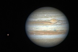
Wes HigginsFor most observers, tonight will show Callisto, Ganymede, Europa and Io grouped to the east of the Mighty Jove, but as time progresses, so do their positions! Try observing over a period of several hours and watch just how quickly these four bright moons shuttle around… You might even catch a possible transit of Io!

To the mid-sized telescope, far greater details begin to appear – such as temperate belts on the planet’s surface and the soft appearance of the Great Red Spot. Finer details are visible during steady seeing, and small things like being able to see which satellite is closer to – or further away from – our vantage point become very easy. Simple things, like watching a moon transit the surface and the resulting shadow on the planet are much easier. With a large telescope, seeing details on Jupiter depends more on seeing conditions. While more aperture allows finer views – conditions are everything when it comes to the Mighty Jove!
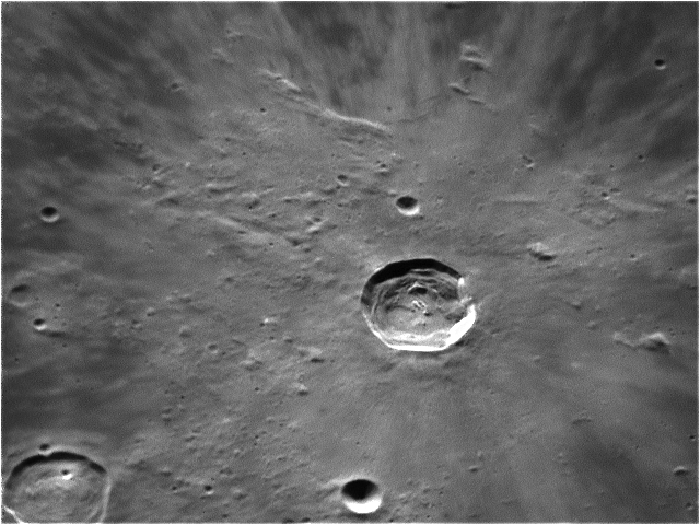
Wes HigginsSunday, June 15 – As we wait on the sky to darken tonight, let’s start our adventures by taking a close look at crater Kepler. Situated just north of central along tonight’s terminator, this great crater named for Johannes Kepler only spans 32 kilometers, but drops to a deep 2750 meters below the surface. This class I crater is a geological hotspot!

As the very first to be mapped by the U.S. Geological Survey, the area around Kepler contains many smooth lava domes reaching no more than 30 meters above the plains. According to records, in 1963 a glowing red area was spotted near Kepler and extensively photographed. Normally one of the brightest regions of the Moon, the brightness value at the time nearly doubled! Although it was rather exciting, scientists later determined the phenomenon was caused by high energy particles from a solar flare reflecting from Kepler’s high albedo surface. In the days ahead all details around Kepler will be lost, so take this opportunity to have a good look at one awesome small crater!
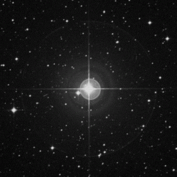
Palomar Observatory, courtesy of Cal TechWhen skies are dark, it’s time to have a look at the 250 light-year distant silicon star Iota Librae (RA 15 12 13 Dec 19 47 28). This is a real challenge for binoculars – but not because the components are so close. In Iota’s case, the near 5th magnitude primary simply overshadows its 9th magnitude companion! In 1782, Sir William Herschel measured them and determined them to be a true physical pair. Yet, in 1940 Librae A was determined to have an equal magnitude companion only 0.2 arcseconds away… And the secondary was proved to have a companion of its own which echoes the primary. A four star system!

No matter if you stayed up late chasing deep sky, or got up early, right now is the time to catch the peak of the June Lyrids meteor shower. Although the Moon will make observing difficult, it’s still an opportunity for those wishing to log their meteor observations. Look for the radiant near bright Vega – you may see up to 15 faint blue meteors per hour from this branch of the May Lyrid meteor stream. Try the ionosphere and radio observing!!

Wishing you clear skies and a great weekend…

This week’s image credits: Detail view of Fra Mauro, Capuanus, Kepler and Jupiter – Credit: Wes Higgins, Shepard at Frau Mauro – Credit: NASA, Iota Librae – Credit: Palomar Observatory, courtesy of Caltech.

Comet Boattini Sails Towards the Sun

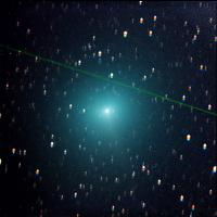
Boattini C/2007 W1 by Dr. Joseph Brimacombe

Serious comet chasers have been watching Comet C/2007 W1 (Boattini) for some time. For awhile, it exceeded its predicted brightness but is back to cruising at normal. During the time this photograph was taken, Boattini was a southern hemisphere object… But not for long. Now its about to round the Sun and head north!

On November 20, 2007 the comet was spotted by Andrea Boattini during the course of the Mt. Lemmon survey in Arizona. Italian Boattini’s interest is in near-Earth asteroids and he during his research has discovered and co-discovered no less than 170 mostly main-belt asteroids. Since that time, Andrea has become involved with the Catalina and Mt. Lemmon program and has made several additional asteroid discoveries. Of these, object 2007 WD5, made headlines during its extremely close approach to Mars at the end of January 2008. Comet C/2007 W1 is Andrea Boattini’s first comet discovery and we hope not the last!

Comet Boattini is sailing through our solar system in a long-period orbit with an oddly small inclination of 10 degrees. In the southern hemisphere, comet observers had a grand chance to watch as it passed 0.21 AU from Earth on June 12, and heads for inferior conjunction by June 15. Right now Comet Boattini is near fifth magnitude and easily seen without aid by experienced southern observers and it’s heading our way…

Comet C/2007 W1 will make its appearance in the northern hemisphere morning sky on July 15th in Cetus as a 7-8th magnitude observing target – easily within reach of small binoculars and telescopes. It will continue to sail north and fade as it heads away from the Sun (and Earth) and will return to a challenging 12th magnitude object. Spectacular? No. Interesting? You betcha’.

What makes Comet C/2007 W1 Boattini a little more special than the rest? Probably because the most recent orbital calculations show that this is W1 Boattini’s first visit into the inner solar system from the Oort Cloud and it won’t be back for about another 63,000 years. While there’s very little chance that it will become another great “first visit” comet like Kohoutek, it’s a great opportunity for you to catch another traveler from the farthest reaches of our solar system.

Good luck!

Comet C/2007 W1 Boattini video and still photography provided by Dr. Joseph Brimacombe from Macedon Ranges Observatory.