Curiosity Rolls into Intriguing ‘Darwin’ at ‘Waypoint 1’ on Long Trek to Mount Sharp

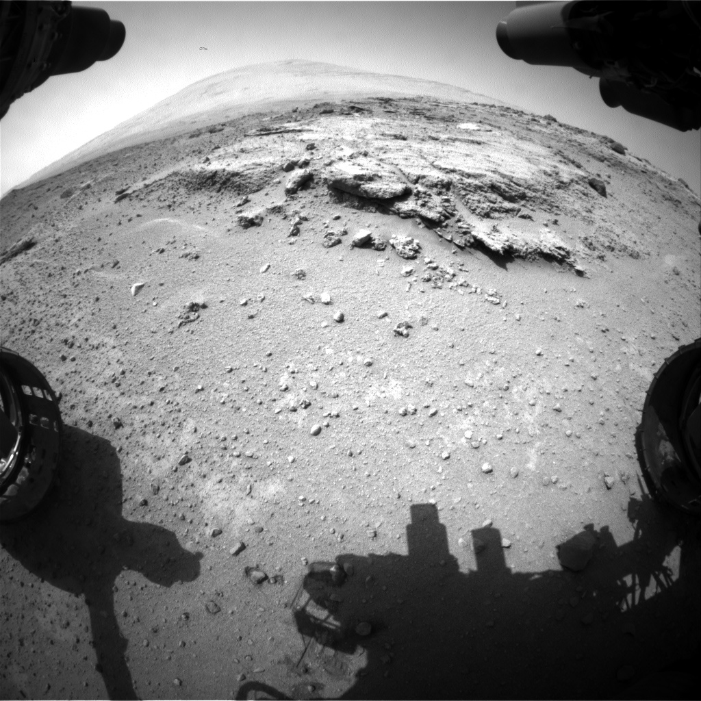
Curiosity’s views a rock outcrop after arriving for a short stay at ‘Waypoint 1’- dramatically back dropped by her primary destination, Mount Sharp. Front hazcam camera image from Sol 393 (Sept 13, 2013). Credit: NASA/JPL-Caltech

Curiosity’s views a rock outcrop at ‘Darwin’ after arriving for a short stay at ‘Waypoint 1’ on Sept 12 (Sol 392) – dramatically back dropped by her primary destination, Mount Sharp. Front hazcam camera image from Sol 393 (Sept 13, 2013). Credit: NASA/JPL-Caltech
Story updated – see close up mosaic views of Darwin outcrop below[/caption]

NASA’s Curiosity Mars rover has just rolled into an intriguing site called ‘Darwin’ at ‘Waypoint 1’- having quickly picked up the driving pace since embarking at last on her epic trek to mysterious Mount Sharp more than two months ago. Did life giving water once flow here on the Red Planet?

Because the long journey to Mount Sharp – the robots primary destination – was certain to last nearly a year, the science team carefully choose a few stopping points for study along the way to help characterize the local terrain. And Curiosity has just pulled into the first of these so called ‘Waypoints’ on Sept 12 (Sol 392), the lead scientist confirmed to Universe Today.

Curiosity has arrived at Waypoint 1,” project scientist John Grotzinger, of the California Institute of Technology in Pasadena, told Universe Today.

“Darwin is named after a geologic formation of rocks from Antarctica.”

She has now driven nearly 20% of the way towards the base of the giant layered Martian mountain she will eventually scale in search of life’s ingredients.

Altogether, the team selected five ‘Waypoints’ to investigate for a few days each as Curiosity travels in a southwestward direction on the road from the first major science destination in the ‘Glenelg’ area to the foothills of Mount Sharp, says Grotzinger.

“We’ll stay just a couple of sols at Waypoint 1 and then we hit the road again,” Grotzinger told me.
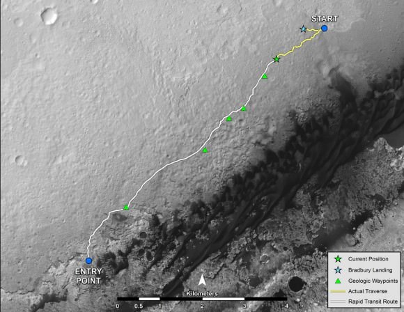
Curiosity's Progress on Rapid Transit Route from 'Glenelg' to Mount Sharp.  Triangles indicate geologic ‘Waypoint’ stopping points along the way.  Curiosity arrived at Waypoint 1 on Sol 392 (Sept 12, 2013). Credit: NASA
Curiosity’s Progress on Rapid Transit Route from ‘Glenelg’ (start at top) to Mount Sharp entry point (bottom). Triangles indicate geologic ‘Waypoint’ stopping points along the way. Curiosity arrived at Waypoint 1 on Sol 392 (Sept 12, 2013). Credit: NASA

‘Waypoint 1’ is an area of intriguing outcrops that was chosen based on high resolution orbital imagery taken by NASA’s Mars Reconnaissance Orbiter (MRO) circling some 200 miles overhead. See route map herein.

In fact the team is rather excited about ‘Waypoint 1’ that’s dominated by the tantalizing rocky outcrop discovered there nicknamed ‘Darwin’.

Although Curiosity will only stay a short time at each of the stops, the measurements collected at each ‘Waypoint’ will provide essential clues to the overall geologic and environmental history of the six wheeled rover’s touchdown zone.

“Waypoint 1 was chosen to help break up the drive,” Grotzinger explained to Universe Today.

“It’s a chance to study outcrops along the way.”

The images from MRO are invaluable in aiding the rover handlers planning activities, selecting Curiosity’s driving route and targeting of the most fruitful science forays during the long trek to Mount Sharp – besides being absolutely crucial for the selection of Gale Crater as the robots landing site in August 2012.

The ‘Darwin’ outcrop may provide more data on the flow of liquid water across the crater floor.
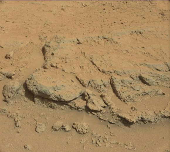
Evolving Excitement Over 'Darwin' Rock Outcrop at 'Waypoint 1'.   For at least a couple of days, the science team of NASA's Mars rover Curiosity is focused on a full-bore science campaign at a tantalizing, rocky site informally called "Darwin."   This view of Darwin was taken with the Mast Camera (Mastcam) on Sol 390 (Sept. 10, 2013). Credit: NASA/JPL-Caltech/Malin Space Science Systems
Evolving Excitement Over ‘Darwin’ Rock Outcrop at ‘Waypoint 1’. For at least a couple of days, the science team of NASA’s Mars rover Curiosity is focused on a full-bore science campaign at a tantalizing, rocky site informally called “Darwin.” This view of Darwin was taken with the Mast Camera (Mastcam) on Sol 390 (Sept. 10, 2013). Credit: NASA/JPL-Caltech/Malin Space Science Systems

The scientists goal is to compare the floor of Gale Crater to the sedimentary layers of 3 mile high (5 kilometer high) Mount Sharp.

Waypoint 1 is just over 1 mile along the approximately 5.3-mile (8.6-kilometer) route from ‘Glenelg’ to the entry point at the base of Mount Sharp.

Curiosity spent over six months investigating the ‘Yellowknife Bay’ area inside Glenelg before departing on July 4, 2013.

What’s the origin of Darwin’s name?

“Darwin comes from a list of 100 names the team put together to designate rocks in the Mawson Quadrangle – Mawson is the name of a geologist who studied Antarctic geology,” Grotzinger told me.

“Recently we left the Yellowknife Quadrangle, so instead of naming rocks after geological formations in Canada’s north, we now turn to formation names of rocks from Antarctica, and Darwin is one of them.

“That will be the theme until we cross into the next quad,” Grotzinger explained.
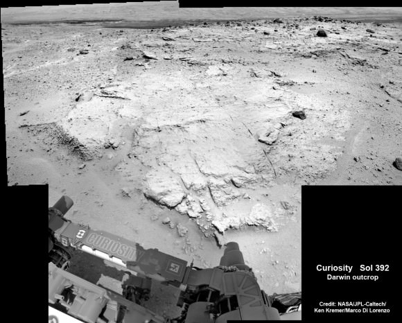
Curiosity investigates the ‘Darwin’ rock outcrop up close after arriving for a short stay at ‘Waypoint 1’ on Sept 12 (Sol 392). This photo mosaic was assembled from navcam images taken on Sept 12, 2013.   Credit: NASA/JPL-Caltech/Ken Kremer/Marco Di Lorenzo
Curiosity investigates the ‘Darwin’ rock outcrop up close after arriving for a short stay at ‘Waypoint 1’ on Sept 12 (Sol 392). This photo mosaic was assembled from navcam images taken on Sept 12, 2013. Credit: NASA/JPL-Caltech/Ken Kremer/Marco Di Lorenzo

Inside Yellowknife Bay, Curiosity conducted the historic first interplanetary drilling into Red Planet rocks and subsequent sample analysis with her duo of state of the art chemistry labs – SAM and CheMin.

At Yellowknife Bay, the 1 ton robot discovered a habitable environment containing the chemical ingredients that could sustain Martian microbes- thereby already accomplishing the primary goal of NASA’s flagship mission to Mars.

“We want to know how the rocks at Yellowknife Bay are related to what we’ll see at Mount Sharp,” Grotzinger elaborated in a NASA statement. “That’s what we intend to get from the waypoints between them. We’ll use them to stitch together a timeline — which layers are older, which are younger.”

On Sept. 5, Curiosity set a new one-day distance driving record for the longest drive yet by advancing 464 feet (141.5 meters) on her 13th month on the Red Planet.

As Curiosity neared Waypoint 1 she stopped at a rise called ‘Panorama Point’ on Sept. 7, spotted an outcrop of light toned streaks informally dubbed ‘Darwin and used her MastCam telephoto camera to collect high resolution imagery.

Curiosity will use her cameras, spectrometers and robotic arm for contact science and a “full bore science campaign” involving in-depth mineral and chemical composition analysis of Darwin and Waypoint 1 for the next few Sols, or Martian days, before resuming the trek to Mount Sharp that dominates the center of Gale Crater.
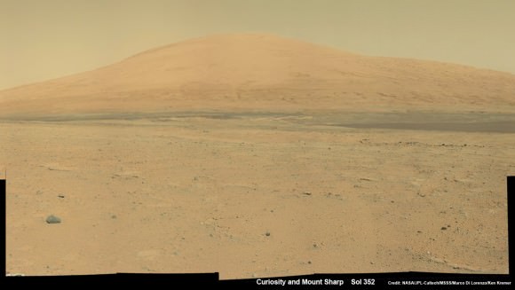
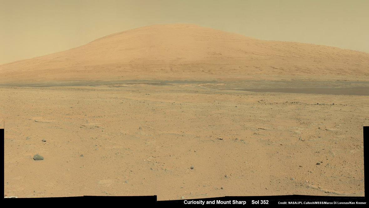
Curiosity Spies Mount Sharp - her primary destination. Curiosity will ascend mysterious Mount Sharp and investigate the sedimentary layers searching for clues to the history and habitability o the Red Planet of billions of years.  This mosaic was assembled from Mastcam camera images taken on Sol 352 (Aug 2, 2013. Credit: NASA/JPL-Caltech/MSSS/ Marco Di Lorenzo/Ken Kremer
Curiosity Spies Mount Sharp – her primary destination. Curiosity will ascend mysterious Mount Sharp and investigate the sedimentary layers searching for clues to the history and habitability o the Red Planet of billions of years. This mosaic was assembled from Mastcam camera images taken on Sol 352 (Aug 2, 2013). Credit: NASA/JPL-Caltech/MSSS/ Marco Di Lorenzo/Ken Kremer

She will not conduct any drilling here or at the other waypoints, several team members have told me, unless there is some truly remarkable ‘Mars-shattering’ discovery.

Why is Curiosity now able to drive longer than ever before?

“We have put some new software – called autonav, or autonomous navigation – on the vehicle right after the conjunction period back in March 2013,” Jim Erickson, Curiosity Project Manager of NASA’s Jet Propulsion Laboratory (JPL), told Universe Today.

“This will increase our ability to drive. But how much it helps really depends on the terrain.”

And so far the terrain has cooperated.

“We are on a general heading of southwest to Mount Sharp,” said Erickson. See the NASA JPL route map.

“We have been going through various options of different planned routes.”

As of today (Sol 394), Curiosity remains healthy, has traveled 2.9 kilometers and snapped over 82,000 images.

If all goes well Curiosity could reach the entry point to Mount Sharp sometime during Spring 2014, at her current driving pace.

Ken Kremer

…………….

Learn more about Curiosity, Mars rovers,LADEE, Cygnus, Antares, MAVEN, Orion and more at Ken’s upcoming presentations

Sep 17/18: LADEE Lunar & Antares/Cygnus ISS Rocket Launches from Virginia”; Rodeway Inn, Chincoteague, VA

Oct 3: “Curiosity, MAVEN and the Search for Life on Mars – (3-D)”, STAR Astronomy Club, Brookdale Community College & Monmouth Museum, Lincroft, NJ, 8 PM

Oct 8: LADEE Lunar & Antares/Cygnus ISS Rocket Launches from Virginia”; Princeton University, Amateur Astronomers Assoc of Princeton (AAAP), Princeton, NJ, 8 PM

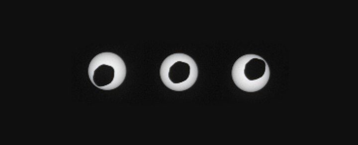
Curiosity Spies a Martian Annular Eclipse

Phobos transiting the Sun as seen by the Mars Curiosity rover on Sol 369. (Credit: NASA/JPL-Caltech/Malin Space Science Systems/Texas A & M University).

It’s always interesting to consider the astronomical goings-on that occur under alien skies.

On August 17th, Curiosity wowed us once again, catching the above sequence of images of the Martian moon Phobos transiting the Sun.

Such phenomena have been captured by the Curiosity, Opportunity and Spirit rovers before, as the twin Martian moons of Deimos & Phobos cross the face of the Sun. But these recent images taken by Curiosity’s right Mastcam pair are some of the sharpest yet.

Orbiting only an average of 6,000 kilometres above the surface of Mars, Phobos is the closest to its primary of any moon in the solar system. It appears about 11 arc minutes in size when directly overhead, about 3 times smaller than our own Moon does from the Earth.

“This event occurred near noon at Curiosity’s location, which put Phobos at its closest point to the rover, appearing larger against the Sun than it would at other times of the day,” Said co-investigator Mark Lemmon of Texas A&M University in a recent press release. “This is the closest to a total eclipse that you can have on Mars.”

Phobos is 40% more distant from an observer standing on the surface of Mars when it is rising above the local horizon than when it is overhead. The Sun is about 20’ arc minutes across as seen from Mars, 66% of its diameter as seen from the Earth.

The sequence above spans only six seconds in duration. You would easily note the apparent motion of Phobos as it drifted by! Also, since Phobos orbits Mars once every 7.7 hours, it actually rises in the west and sets in the east. The Martian day is over three times this span, at 24.6 hours long. Deimos has a more sedate orbit of 30.4 hours in duration.

The twin Moons of Deimos and Phobos were discovered this month back during the opposition of 1877 by Asaph Hall using the United States Naval Observatory’s newly installed 65 centimetre refractor. The moons are just within the grasp of eagle-eyed amateurs near opposition. You’ve got another opportunity to cross these elusive moons off of your life list coming up in the Spring of 2014.

image_preview
The telescope that was used to discover the moons of Mars. (Credit: The United States Naval Observatory).

It’s especially captivating that you can make out the irregular “potato shape” of Phobos in the above images. With low orbital inclinations relative to the equator of Mars of 1.1 degrees for Phobos and 0.9 degrees for Deimos, solar transits are not an uncommon occurrence, transpiring somewhere along the Martian surface with every orbit. If Phobos were twice as close to Mars, it would completely cover the Sun in a total solar eclipse. What Curiosity gave us this month is more akin to an annular eclipse with a ragged central shadow. An annular eclipse occurs when the occulting body is too distant to cover the Sun, leaving a bright, shining ring, or annulus.

On the Earth, we live in an epoch where annular eclipses are slightly more common than total solar eclipses, as the Moon currently recedes from us to the tune of 3.8 centimetres a year. About 1.4 billion years from now, the last total solar eclipse will be seen from the Earth. The next purely annular eclipse as seen from Earth occurs on April 29th, 2014 across Australia and the Antarctic.

Conversely, Phobos is in a “death spiral,” meaning that it will one day crash into Mars about 30-50 million years from now. This also means that in about half that time, it will also be large enough to visually cover the Sun when crossing it near local noon.  For a brief time far in the future, jagged total solar eclipses will be visible from Mars. That is, if the gravitational field of Mars doesn’t rip Phobos apart before that!

But beyond just aesthetics, these observations serve a scientific purpose as well. These phenomena serve to refine our understanding of the precise positions of Phobos and Deimos and their orbits.

“This one is by far the most detailed image of any Martian lunar transit ever taken, and it is especially useful because it is annular. It was taken closer to the Sun’s center than predicted, so we learned something.”

The track during the August 17th observation was off by about 2-3 kilometres, allowing for a surprise central transit of the Sun as seen from Curiosity’s location.

Both Phobos and Deimos are captured asteroids only 22.2 & 12.6 kilometres across, respectively. Both must be subject to occasional bombardment from meteorites blasted off of the surface of nearby Mars. Sample return missions to Phobos have been proposed. Russia’s ill-fated Phobos-Grunt mission would’ve done just that.

Will humans ever stand on the surface of the Red Planet and witness an annular eclipse of the Sun by Phobos in person? Well, if we make it there by November 10th, 2084, observers placed on the slopes of Elysium Mons will witness just such an event… with a rare transit of Earth and the Moon to boot!:

Arthur C. Clarke wrote of a transit of Earth from Mars that occurred in 1984 in his science fiction short story Transit of Earth.

Hey, I’m marking my calendar for the 2084 event… assuming, of course, my android body is ready by then!

Curiosity Conducts Science on the Go and Zooms to Stunning Mount Sharp

Curiosity Spies Mount Sharp - her primary destination. Curiosity will ascend mysterious Mount Sharp and investigate the sedimentary layers searching for clues to the history and habitability o the Red Planet of billions of years. This mosaic was assembled from Mastcam camera images taken on Sol 352 (Aug 2, 2013. Credit: NASA/JPL-Caltech/MSSS/ Marco Di Lorenzo/Ken Kremer

Curiosity Spies Mount Sharp – her primary destination. Curiosity will ascend mysterious Mount Sharp and investigate the sedimentary layers searching for clues to the history and habitability of the Red Planet over billions of years. But first she must safely trespass through the treacherous dark dunes fields. This mosaic was assembled from over 2 dozen Mastcam camera images taken on Sol 352 (Aug 2, 2013). Credit: NASA/JPL-Caltech/MSSS/ Marco Di Lorenzo/Ken Kremer
See the full mosaic below [/caption]

It’s never a dull moment for NASA’s Curiosity rover at T Plus 1 Year since touchdown on the Red Planet and T Minus 1 year to arriving at her primary target, the huge mountain overwhelming the center of the landing site inside Gale Crater.

Curiosity is literally and figuratively zooming in on stunningly beautiful and mysterious Mount Sharp (see our new mosaics above/below), her ultimate destination, while conducting ‘Science on the Go’ with her duo of chemistry labs – SAM and CheMin – and 8 other science instruments as she passes the 2 kilometer driving milestone today; Aug 20 !

“We are holding samples for drops to ChemMin and SAM when the science team is ready for it,” Jim Erickson, Curiosity Project Manager of NASA’s Jet Propulsion Laboratory (JPL), told Universe Today in an exclusive interview.

“Curiosity has landed in an ancient river or lake bed on Mars,” Jim Green, Director of NASA’s Planetary Science Division, told Universe Today.

So, those samples were altered by liquid Martian water – a prerequisite for life.

Curiosity Spies Mount Sharp - her primary destination. Curiosity will ascend mysterious Mount Sharp and investigate the sedimentary layers searching for clues to the history and habitability of the Red Planet over billions of years.  This mosaic was assembled from over 3 dozen Mastcam camera images taken on Sol 352 (Aug 2, 2013. Credit: NASA/JPL-Caltech/MSSS/ Marco Di Lorenzo/Ken Kremer
Curiosity Spies Mount Sharp – her primary destination. Curiosity will ascend mysterious Mount Sharp and investigate the sedimentary layers searching for clues to the history and habitability of the Red Planet over billions of years. But first she must safely trespass through the treacherous dark dunes fields. This mosaic was assembled from over 3 dozen Mastcam camera images taken on Sol 352 (Aug 2, 2013.
Credit: NASA/JPL-Caltech/MSSS/ Marco Di Lorenzo/Ken Kremer-kenkremer.com

In fact the car sized rover has saved samples from both the ‘John Klein’ and ‘Cumberland’ drill sites collected previously in the ‘Yellowknife Bay’ area for analysis by the miniaturized labs in the rovers belly -when the time is right.

“Curiosity has stored a Cumberland sample and still has a John Klein sample on board for future use,” Erickson explained.

And that time has now arrived!

“We have put a sample from the Cumberland drill hole into SAM for more isotopic measurements,” reported science team member John Bridges in a blog update on Sol 363, Aug. 14, 2013.

“The sample had been cached within the robotic arm’s turret.”

Curiosity is multitasking – conducting increasingly frequent traverses across the relatively smooth floor of Gale Crater while running research experiments for her science handlers back here on Earth.

NASA’s Curiosity rover make tracks to Mount Sharp (at left) across the floor of Gale Crater. The rover paused to image the windblown ripple at right, below the hazy crater rim. The wheel tracks are about eight  feet apart. This panoramic mosaic was assembled from a dozen navcam camera images taken on Sol 354 (Aug 4, 2013. Credit: NASA/JPL-Caltech/Ken Kremer Marco Di Lorenzo
NASA’s Curiosity rover make tracks to Mount Sharp (at left) across the floor of Gale Crater. The rover paused to image the windblown ripple at right, below the hazy crater rim. The wheel tracks are about eight feet apart. This panoramic mosaic was assembled from a dozen navcam camera images taken on Sol 354 (Aug 4, 2013). Credit: NASA/JPL-Caltech/Ken Kremer/Marco Di Lorenzo

She’s captured stunning new views of Mount Sharp – rising 5 km (3 miles) high into the sky – and movies of Mars tiny pair of transiting moons while ingesting new portions of the drilled rock samples acquired earlier this year.

Here’s our video compilation of Phobos and Deimos transiting on Aug 1, 2013

Video caption: Transit of Phobos in front of Deimos, taken by MSL right MastCam imager on Sol 351 around 3:12 AM local time (Aug 1, 2013, 8:42 UTC); 16 original frames + 14 interpolated (5x speed-up). Credit: NASA/JPL-Caltech/MSSS/ Marco Di Lorenzo/Ken Kremer

The sample analysis is still in progress.

“The SAM data have not all been received yet,” wrote science team member Ken Herkenhoff in a blog update.

Earlier analysis of sample portions from both ‘John Klein’ and ‘Cumberland’ revealed that the Yellowknife Bay area on Mars possesses the key mineral ingredients proving that Red Planet was once habitable and could have sustained simple microbial life forms.

The scientists are seeking further evidence and have yet to detect organic molecules – which are the building blocks of life as we know it.

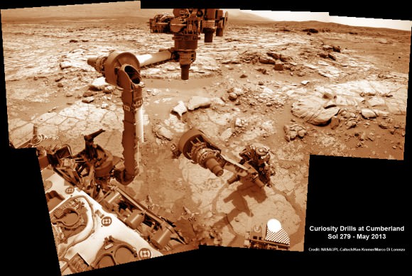
This time lapse mosaic shows Curiosity maneuvering her robotic arm to drill into her 2nd   martian rock target named “Cumberland” to collect powdery Martian material on May 19, 2013 (Sol 279) for analysis by her onboard chemistry labs; SAM & Chemin. The photomosaic was stitched from raw images captured by the navcam cameras on May 14 & May 19 (Sols 274 & 279).  Credit: NASA/JPL-Caltech/Ken Kremer/Marco Di Lorenzo
This time lapse mosaic shows Curiosity maneuvering her robotic arm to drill into her 2nd martian rock target named “Cumberland” to collect powdery Martian material on May 19, 2013 (Sol 279) for analysis by her onboard chemistry labs; SAM & Chemin- see 3 inlet ports lower left. The photomosaic was stitched from raw images captured by the navcam cameras on May 14 & May 19 (Sols 274 & 279). Credit: NASA/JPL-Caltech/Ken Kremer/Marco Di Lorenzo

Yellowknife Bay resembles a dried out river bed where liquid water once flowed eons ago when the Red Planet was far warmer and wetter than today.

As the 1 ton robot ascends Mount Sharp, she will examine sedimentary layers layed down on ancient Mars over hundreds of millions and perhaps billions of years of past history and habitability.

And just as the rover was celebrating 1 year on Mars on Aug 5/6, she found an intriguing sand dune on Sol 354. See our mosaic

“The rover paused to take images of its tracks after crossing a windblown ripple,” Herkenhoff reported.

As the six wheeled rover approaches Mount Sharp over the next year, she will eventually encounter increasing treacherous dunes that she must cross before beginning her mountain climbing foray.

As of today, Sol 369 (Aug. 20) Curiosity has broken through the 2 kilometer driving mark with a new 70 meter drive, snapped over 75,000 images and fired over 75,000 laser shots.

Mount Sharp is about 8 kilometers (5 miles) distant as the Martian crow flies.

How long will the journey to Mount Sharp require?

“Perhaps about a year,” Erickson told me. “We are trying to make that significantly faster by bringing autonav [autonomous navigation software] online.”

“That will help. But how much it helps really depends on the terrain.”

So far so good.

Meanwhile NASA’s next Mars orbiter called MAVEN (for Mars Atmosphere and Volatile Evolution), recently arrived at the Kennedy Space Center after a cross country flight.

Kennedy technicians are completing assembly and check out preparations for MAVEN’s blastoff to the Red Planet on Nov. 18 from Florida atop an Atlas V rocket similar to the one that launched Curiosity nearly 2 years ago.

And I’ll be at Kennedy to report up close on MAVEN’s launch.

Stay tuned.

Ken Kremer

Moon Dance: Curiosity Rover Captures Movie of Phobos and Deimos Together

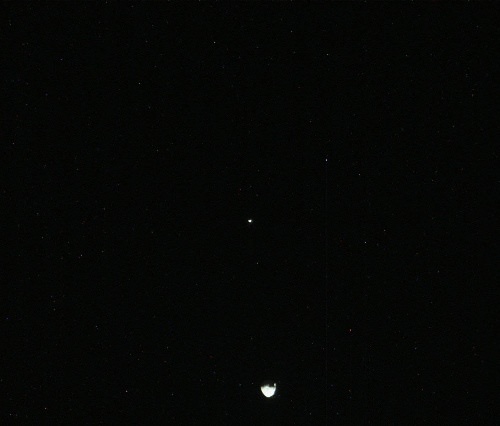
This image was taken by the Curiosity rover's right Mastcamy on Sol 351 (2013-08-01 08:44:11 UTC). Image Credit: NASA/JPL-Caltech/MSSS.

Sol 351 for the Curiosity rover on Mars was a marvelous night for a moon dance. The Mars Science Laboratory rover caught sight of Mars’ two moons, Phobos and Deimos together in the sky. And not just one image was captured: the rover’s Mast Camera captured a series of 41 images to allow the MSL team to create this timelapse movie of the dance, where the smaller moon Diemos is occulted by Phobos.

To our knowledge, this the first time the two moons have been seen together in any image from the surface of Mars, let alone a sequence of images. The Mars Express spacecraft took images of the moons together in 2009 from orbit.

The movie from MSL takes just a few seconds to watch, but the team said the real time it took to shoot the 41 images was 55 seconds.

Sol 351 equates to August 1, 2013 here on Earth.

See a raw still shot below:

Update: JPL has now put out a press release about the movie, confirming that no previous images from missions on the surface has caught one moon eclipsing the other.

They also said there was a slight delay in getting these images from the rover, as there were higher-priority images in the queue that were to be used for planning the rover’s drives.

Scientists know that the orbit of Phobos is very slowly getting closer to Mars, while the orbit of Deimos may be slowly getting farther from the planet. These observations of Phobos and Deimos help researchers make knowledge of the moons’ orbits even more precise.

“The ultimate goal is to improve orbit knowledge enough that we can improve the measurement of the tides Phobos raises on the Martian solid surface, giving knowledge of the Martian interior,” said Mark Lemmon of Texas A&M University, College Station, a co-investigator for use of Curiosity’s Mastcam. “We may also get data good enough to detect density variations within Phobos and to determine if Deimos’ orbit is systematically changing.”

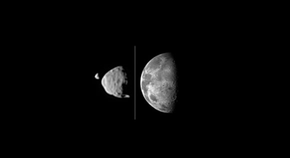
There’s also this nice graphic comparing our Moon to Phobos and Deimos:

his illustration provides a comparison for how big the moons of Mars appear to be, as seen from the surface of Mars, in relation to the size that Earth's moon appears to be when seen from the surface of Earth. Earth's moon actually has a diameter more than 100 times greater than the larger Martian moon, Phobos. However, the Martian moons orbit much closer to their planet than the distance between Earth and Earth's moon. Credit: NASA/JPL-Caltech/Malin Space Science Systems/Texas A&M Univ.
his illustration provides a comparison for how big the moons of Mars appear to be, as seen from the surface of Mars, in relation to the size that Earth’s moon appears to be when seen from the surface of Earth. Earth’s moon actually has a diameter more than 100 times greater than the larger Martian moon, Phobos. However, the Martian moons orbit much closer to their planet than the distance between Earth and Earth’s moon. Credit: NASA/JPL-Caltech/Malin Space Science Systems/Texas A&M Univ.

Although Phobos has a diameter less than one percent the diameter of Earth’s Moon, Phobos also orbits much closer to Mars than our moon’s distance from Earth. As seen from the surface of Mars, Phobos looks about half as wide as what Earth’s moon looks like to viewers on Earth.

Nice work Curiosity and team!

Curiosity rover Celebrates 1 Year on Mars with Dramatic Discoveries

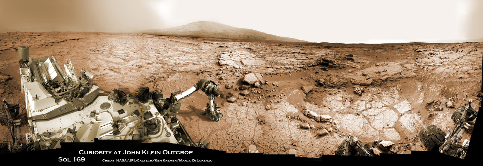
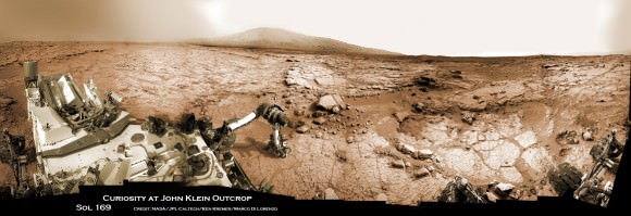
Curiosity accomplished Historic 1st drilling into Martian rock at John Klein outcrop on Feb 8, 2013 (Sol 182), shown in this context mosaic view of the Yellowknife Bay basin taken on Jan. 26 (Sol 169). The robotic arm is pressing down on the surface at John Klein outcrop of veined hydrated minerals – dramatically back dropped with her ultimate destination; Mount Sharp. Credit: NASA/JPL-Caltech/Ken Kremer/Marco Di Lorenzo

Curiosity accomplished Historic 1st drilling into Martian rock at John Klein outcrop on Feb 8, 2013 (Sol 182), shown in this context mosaic view of the Yellowknife Bay basin taken on Jan. 26 (Sol 169). The robotic arm is pressing down on the surface at John Klein outcrop of veined hydrated minerals – dramatically back dropped with her ultimate destination; Mount Sharp.
Credit: NASA/JPL-Caltech/Ken Kremer/Marco Di Lorenzo
Story updated with further details[/caption]

NASA’s mega Mars rover Curiosity is celebrating 1 Year on the Red Planet since the dramatic landing on Aug. 6, 2012 by reveling in a string of groundbreaking science discoveries demonstrating that Mars could once have supported past life – thereby accomplishing her primary science goal – and with a promise that the best is yet to come!

“We now know Mars offered favorable conditions for microbial life billions of years ago,” said the mission’s project scientist, John Grotzinger of the California Institute of Technology in Pasadena.

“Curiosity has landed in an ancient river or lake bed on Mars,” Jim Green, Director of NASA’s Planetary Science Division, told Universe Today.

Curiosity is now speeding onwards towards Mount Sharp, the huge 3.4 mile (5. 5 km) mountain dominating the center of her Gale Crater landing site – and which is the primary destination of the mission.

During Year 1, Curiosity has transmitted over 190 gigabits of data, captured more than 71,000 images, fired over 75,000 laser shots to investigate the composition of rocks and soil and drilled into two rocks for sample analysis by the pair of state-of-the-art miniaturized chemistry labs housed in her belly – SAM & CheMin.

“From the sophisticated instruments on Curiosity the data tells us that this region could have been habitable in Mars’ distant past,” Green told me.

“This is a major step forward in understanding the history and evolution of Mars.”

And just in the nick of time for her 1 year anniversary, the car sized robot just passed the 1 mile (1.6 kilometer) driving mark on Aug. 1, or Sol 351.

Mount Sharp still lies roughly 5 miles (8 kilometers) distant – as the Martian crow flies.

“We will be on a general heading of southwest to Mount Sharp,” Jim Erickson, Curiosity Project Manager of NASA’s Jet Propulsion Laboratory (JPL), told Universe Today in an exclusive interview. See the NASA JPL route maps below.

“We have been going through various options of different planned routes.”

How long will the journey to Mount Sharp take?

“Perhaps about a year,” Erickson told me.

“We have put some new software – called autonav, or autonomous navigation – on the vehicle right after the conjunction period back in March 2013. This will increase our ability to drive.”

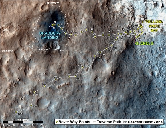
The total distance driven by NASA's Mars rover Curiosity passed the one-mile mark a few days before the first anniversary of the rover's landing on Mars.  This map traces where Curiosity drove between landing at "Bradbury Landing" on Aug. 5, 2012, PDT, (Aug. 6, 2012 (Universal Time and EDT) and the position reached during the mission's 351st Martian day, or sol, (Aug. 1, 2013). The Sol 351 leg added 279 feet (85.1 meters) and brought the odometry since landing to about 1.05 miles (1,686 meters).  Credit: NASA/JPL-Caltech/Univ. of Arizona
The total distance driven by NASA’s Mars rover Curiosity passed the one-mile mark a few days before the first anniversary of the rover’s landing on Mars. This map traces where Curiosity drove between landing at “Bradbury Landing” on Aug. 5, 2012, PDT, (Aug. 6, 2012 (Universal Time and EDT) and the position reached during the mission’s 351st Martian day, or sol, (Aug. 1, 2013). The Sol 351 leg added 279 feet (85.1 meters) and brought the odometry since landing to about 1.05 miles (1,686 meters). Credit: NASA/JPL-Caltech/Univ. of Arizona

“We are trying to make that significantly faster by bringing the new autonav online. That will help. But how much it helps really depends on the terrain.”

So far the terrain has not been problematical.

“Things are going very well and we have a couple of drives under our belt,” said Erickson, since starting the long trek to Mount Sharp about a month ago.

The lower reaches of Mount Sharp are comprised of exposed geological layers of sedimentary materials that formed eons ago when Mars was warmer and wetter, and much more hospitable to microscopic life.

“It has been gratifying to succeed, but that has also whetted our appetites to learn more,” says Grotzinger. “We hope those enticing layers at Mount Sharp will preserve a broad diversity of other environmental conditions that could have affected habitability.”

Indeed, Curiosity’s breakthrough discovery that the surface of Mars possesses the key chemical ingredients required to sustain microbial life in a habitable zone, has emboldened NASA to start mapping out the future of Mars exploration.

NASA announced plans to start work on a follow on robotic explorer launching in 2020 and develop strategies for returning Martian samples to Earth and dispatching eventual human missions to Mars in the 2030’s using the new Orion capsule and SLS Heavy lift rocket.

“NASA’s Mars program is back on track with the 2016 InSight lander and the 2020 rover,” Jim Green, Director of NASA’s Planetary Science Division, told Universe Today in an interview.

“Successes of our Curiosity — that dramatic touchdown a year ago and the science findings since then — advance us toward further exploration, including sending humans to an asteroid and Mars,” said NASA Administrator Charles Bolden in a statement.

“Wheel tracks now, will lead to boot prints later.”

Following the hair-raising touchdown using with the never before used sky-crane descent thrusters, the science team directed the 1 ton robot to drive to a nearby area of interesting outcrops on the Gale crater floor – at a place called Glenelg and Yellowknife Bay.

Along the way, barely 5 weeks after landing, Curiosity found a spot laden with rounded pebbles at the Hottah outcrop of concretions that formed in an ancient stream bed where hip deep liquid water once flowed rather vigorously.

In February 2013, Curiosity conducted the historic first ever interplanetary drilling into Red Planet rocks at the ‘John Klein’ outcrop inside Yellowknife Bay that was shot through with hydrated mineral veins of gypsum.

The Yellowknife Bay basin looks like a dried up river bed.

This scene combines seven images from the telephoto-lens camera on the right side of the Mast Camera (Mastcam) instrument on NASA's Mars rover Curiosity   on Sol 343 of the rover's work on Mars (July 24, 2013).  Credit: NASA/JPL-Caltech/Malin Space Science Systems
This scene combines seven images from the telephoto-lens camera on the right side of the Mast Camera (Mastcam) instrument on NASA’s Mars rover Curiosity on Sol 343 of the rover’s work on Mars (July 24, 2013). The center of the scene is toward the southwest. Credit: NASA/JPL-Caltech/Malin Space Science Systems

Analysis of pulverized portions of the gray colored rocky powder cored from the interior of ‘John Klein’ revealed evidence for phyllosilicates clay minerals that typically form in pH neutral water. These starting findings on the crater floor were unexpected and revealed habitable environmental conditions on Mars – thus fulfilling the primary science goal of the mission.

See herein our context panoramic mosaic from Sol 169 showing the robotic arm touching and investigating the Martian soil and rocks at ‘John Klein’.

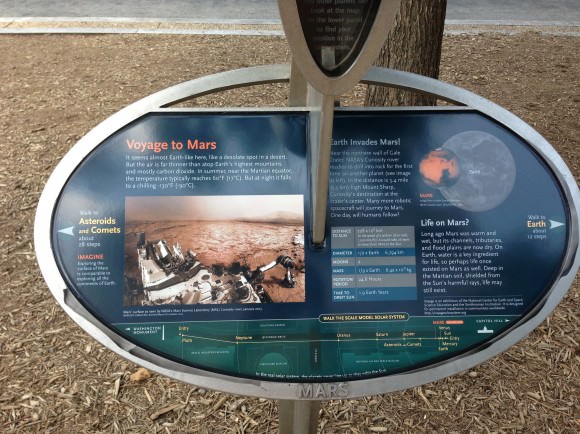
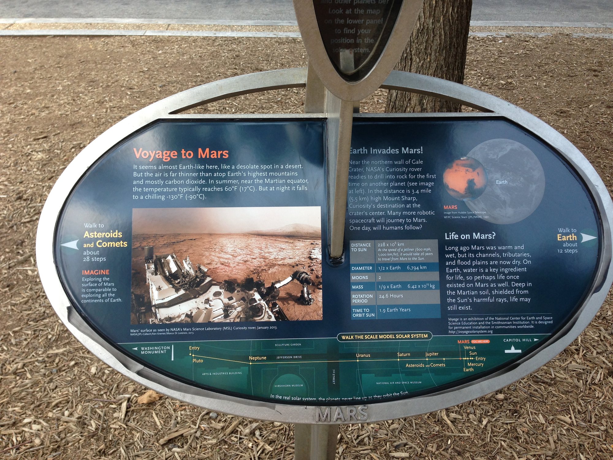
And if you take a visit to Washington, DC, you can see our panorama (assembled by Ken Kremer and Marco Di Lorenzo) on permanent display at a newly installed Solar System exhibit at the US National Mall in front of the Smithsonian National Air & Space Museum- details here.

A mosaic by the Mars Science Laboratory Curiosity rover, assembled by Ken Kremer and Marco Di Lorenzo is now part of the permanent Solar System Exhibit outside the National Air and Space Museum on the US National Mall in Washington, D.C. Image courtesy Ken Kremer.
A mosaic by the Mars Science Laboratory Curiosity rover, assembled by Ken Kremer and Marco Di Lorenzo is now part of the permanent Solar System Exhibit outside the National Air and Space Museum on the US National Mall in Washington, D.C. Image courtesy NCESSE.

“We have found a habitable environment [at John Klein] which is so benign and supportive of life that probably if this water was around, and you had been on the planet, you would have been able to drink it,” says Grotzinger, summing up the mission.

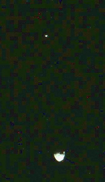
Curiosity captured unique view of Martian moon Phobos & Diemos together on Sol 351 (Aug 1, 2013). Credit: NASA/JPL/MSSS, contrast enhanced by Marco Di Lorenzo and Ken Kremer
Curiosity captured unique and rare view of tiny Martian moons Phobos & Deimos together on Sol 351 (Aug 1, 2013). Look close and see craters on pockmarked Phobos. Credit: NASA/JPL/MSSS, contrast enhanced by Marco Di Lorenzo and Ken Kremer
On the long road to Mount Sharp, Curiosity will make occasional stops for science.

This past week she captured rare sky watching images of the diminutive Martian moons – Phobos and Deimos – together!

Meanwhile, Curiosity’s 10 year old sister rover Opportunity Is trundling merrily along and will arrive shortly at her own mountain climbing goal on the opposite of Mars.

And NASA’s next Mars orbiter called MAVEN (for Mars Atmosphere and Volatile Evolution), has just arrived intact at the Kennedy Space Center after a cross country trip aboard a USAF C-17.

Technicians at Kennedy will complete final preparations for MAVEN’s blastoff to the Red Planet on Nov. 18 from the Florida Space Coast atop an Atlas V rocket.

On Tuesday, Aug 6, NASA will broadcast a half day of new programming on NASA TV commemorating the landing and discussing the science accomplished so far and what’s coming next.

And stay tuned for more astonishing discoveries during ‘Year 2’ on the Red Planet from our intrepid rover Curiosity – Starting Right Now !

Ken Kremer

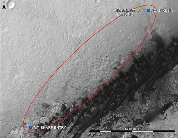
Curiosity Route Map From 'Glenelg' to Mount Sharp. This map shows where NASA's Mars rover Curiosity landed in August 2012 at "Bradbury Landing"; the area where the rover worked from November 2012 through May 2013 at and near the "John Klein" target rock in the "Glenelg" area; and the mission's next major destination, the entry point to the base of Mount Sharp.  Credit: NASA/JPL-Caltech/Univ. of Arizona
Curiosity Route Map From ‘Glenelg’ to Mount Sharp
This map shows where NASA’s Mars rover Curiosity landed in August 2012 at “Bradbury Landing”; the area where the rover worked from November 2012 through May 2013 at and near the “John Klein” target rock in the “Glenelg” area; and the mission’s next major destination, the entry point to the base of Mount Sharp. Credit: NASA/JPL-Caltech/Univ. of Arizona

See the Curiosity Mars Panorama on Permanent Display at the US National Mall

A mosaic by the Mars Science Laboratory Curiosity rover, assembled by Ken Kremer and Marco Di Lorenzo is now part of the permanent Solar System Exhibit outside the National Air and Space Museum on the US National Mall in Washington, D.C. Image courtesy Ken Kremer.

Congratulations to Universe Today writer Ken Kremer and his partner in image editing, Marco Di Lorenzo, who have had one of the panoramas they created from the Curiosity rover’s imagery included in a permanent Solar System exhibit outside the National Air and Space Museum on the US National Mall in Washington, D.C. The exhibit is called “Voyage” and was created by the National Center for Earth and Space Science Education (NCESSE) and is sponsored in part by NASA.

Ken said the NCESSE contacted him a few months ago back to use the mosaic — from Sol 169 of Curiosity’s time on Mars — and the project is finally complete. “They liked and chose it because it evokes a human presence on Mars with the rover in the foreground,” Ken said.

The exhibit is a one to 10-billion scale model of our Solar System—spanning 600 meters (6,000 feet) from the National Air and Space Museum to the Smithsonian Castle Building, and Ken and Marco’s image from the Curiosity rover is part of the information about Mars.

Here’s a description of the exhibit from NCESSE website:

“The Voyage exhibition on the National Mall, installed in 2001, was created through a partnership between Challenger Center for Space Science Education, the Smithsonian Institution, and NASA. A summer 2013 update of this exhibition’s content was undertaken by the National Center for Earth and Space Science Education and the Smithsonian Institution, through a grant from the District of Columbia Space Grant Consortium. To learn more, and view photo albums of all Voyage exhibitions, visit the Voyage National Program page.”

Here’s a closeup of Ken and Marco’s mosaic:

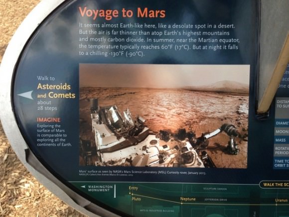
Close up of the Mars placard for the Voyager Solar System exhibit. Image courtesy of Ken Kremer.

And a full view of the image is below.

You can learn more about the exhibit at the NCESSE Voyage webpage. Again, congratulations to Ken and Marco!

Curiosity accomplished Historic 1st drilling into Martian rock at John Klein outcrop on Feb 8, 2013 (Sol 182), shown in this context mosaic view of the Yellowknife Bay basin taken on Jan. 26 (Sol 169). The robotic arm is pressing down on the surface at John Klein outcrop of veined hydrated minerals - dramatically back dropped with  her ultimate destination; Mount Sharp.  Credit: NASA/JPL-Caltech/Ken Kremer/Marco Di Lorenzo
Curiosity accomplished Historic 1st drilling into Martian rock at John Klein outcrop on Feb 8, 2013 (Sol 182), shown in this context mosaic view of the Yellowknife Bay basin taken on Jan. 26 (Sol 169). The robotic arm is pressing down on the surface at John Klein outcrop of veined hydrated minerals – dramatically back dropped with her ultimate destination; Mount Sharp. Credit: NASA/JPL-Caltech/Ken Kremer/Marco Di Lorenzo

Watch the Curiosity Rover’s First Year on Mars in Two Minutes

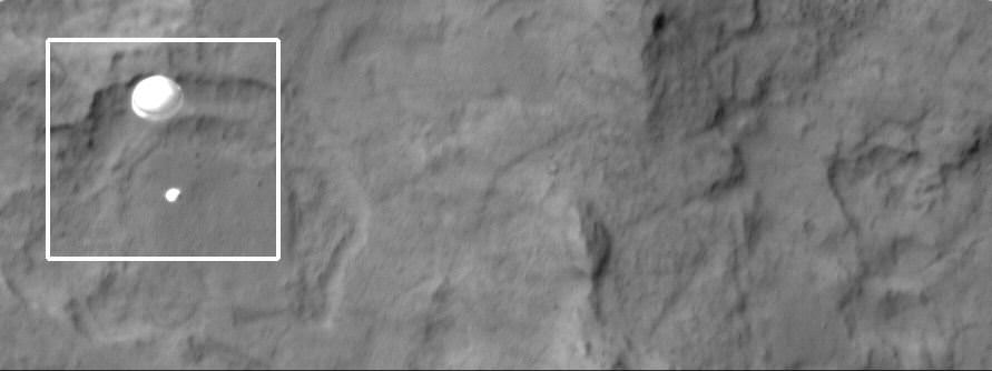
The HiRISE Camera on the Mars Reconnaissance Orbiter captured the Curiosity rover descending on its parachute to land on Mars. Credit: NASA/JPL/Arizona State University.

Whew — the past year flew by fast! Can you believe it’s almost been a year already since the Mars Science Laboratory rover Curiosity thrilled the world with its nail-biting, sky-craning, engineer-high-fiving landing on Mars on August 6, 2012? Now for something even faster, here you can see what Curiosity has done since landing — where she’s roved, drilled, shook, and captured the views in this sped-up look at her travels, explorations and discoveries.

And since you can never see the landing highlight video too many times, we’ve posted it below:

MAVEN Takes Final Test Spins, Flexes Solar Panels Before Imminent Trek to Florida Launch Site

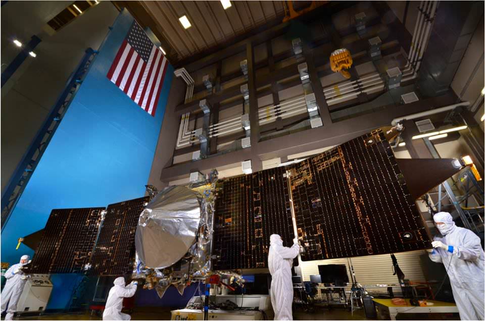
The solar panels on the MAVEN spacecraft are deployed as part of environmental testing procedures at Lockheed Martin Space Systems in Littleton, Colorado, before shipment to Florida 0on Aug. 2 and blastoff for Mars on Nov. 18, 213. Credit: Lockheed Martin

The solar panels on NASA’s MAVEN Mars orbiter are deployed as part of environmental testing procedures at Lockheed Martin Space Systems in Littleton, Colorado, before shipment to Florida on Aug. 2 and blastoff for Mars on Nov. 18, 2013. Credit: Lockheed Martin
Watch cool testing videos below![/caption]

MAVEN is NASA’s next mission to Mars and in less than three days time the spacecraft ships out on a cross country trek for the first step on the long sojourn to the Red Planet.

But before all that, technicians took MAVEN for a final spin test, flexed her solar arrays and bombarded her with sound and a whole lot more.

On Aug. 2, MAVEN (Mars Atmosphere and Volatile EvolutioN Mission) journeys half a continent from its assembly facility at Lockheed Martin in Littleton, Colorado to the Kennedy Space Center and the Florida Space Coast aboard a USAF C-17.

Unlike Curiosity, which is roving across a crater floor on the Red Planet at this very moment, MAVEN is an orbiter with a first of its kind mission.

MAVEN is the first spacecraft from Earth devoted to investigating and understanding the upper atmosphere of Mars.

The goal is determining how and why Mars lost virtually all of its atmosphere billions of years ago, what effect that had on the climate and where did the atmosphere and water go?

To ensure that MAVEN is ready for launch, technicians have been busy this year with final tests of the integrated spacecraft.

Check out this video of MAVEN’s Dry Spin Balance Test

The spin balance test was conducted on the unfueled spacecraft on July 9, 2013 at Lockheed Martin Space Systems in Littleton, Colorado.

NASA says the purpose of the test “is to ensure that the fully integrated spacecraft is correctly balanced and to determine the current center of gravity. It allows the engineering team to fine-tune any necessary weight adjustments to precisely fix the center of gravity where they want it, so that it will perform as expected during the cruise to Mars.”

It was the last test to be completed on the integrated spacecraft before its shipment to Florida later this week.

This next video shows deployment tests of the two “gull-wing” solar panels at Lockheed Martin Space Systems.

Wingtip to wingtip, MAVEN measures 11.43 m (37.5 feet) in length.

In mid May, MAVEN was moved into a Thermal Vacuum Chamber at Lockheed Martin for 19 days of testing.


The TVAC test exposed MAVEN to the utterly harsh temperatures and rigors of space similar to those it will experience during its launch, cruise, and mission at Mars.

MAVEN is slated to blast off atop an Atlas V-401 rocket from Cape Canaveral Air Force Station, Florida on Nov. 18, 2013. The 2000 pound (900 kg) spacecraft will be housed inside a 4 meter payload fairing.

After a 10 month interplanetary voyage it will join NASA’s armada of four robotic spacecraft when it arrives in Mars orbit in September 2014.

Scientists hope that measurements from MAVEN will help answer critical questions like whether, when and how long the Martian atmosphere was once substantial enough to sustain liquid water on its surface and support life.

“What we’re doing is measuring the composition of the atmosphere as a measure of latitude, longitude, time of day and solar activities,” said Paul Mahaffy, of NASA’s Goddard Space Flight Center in Greenbelt, Md, and the principal investigator for MAVEN’s mass spectrometer instrument.

“We’re trying to understand over billions of years how the atmosphere has been lost.”

Ken Kremer

…………….
Learn more about MAVEN, Cygnus, Antares, LADEE, Mars rovers and more at Ken’s upcoming lecture presentations

Aug 12: “RockSat-X Suborbital Launch, LADEE Lunar & Antares Rocket Launches from Virginia”; Rodeway Inn, Chincoteague, VA, 8 PM

Oct 3: “Curiosity and the Search for Life on Mars – (3-D)”, STAR Astronomy Club, Brookdale Community College & Monmouth Museum, Lincroft, NJ, 8 PM

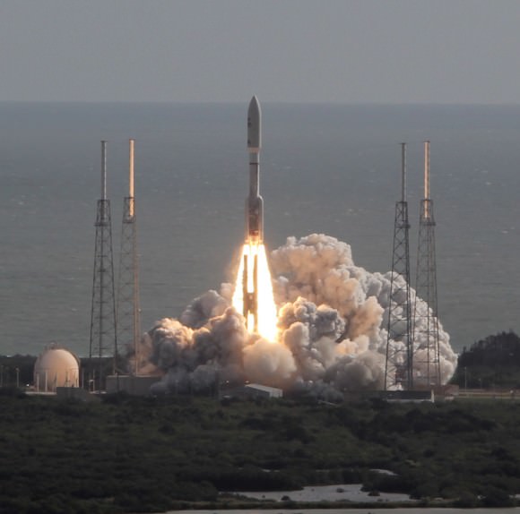
NASA’s MAVEN orbiter is due to blast off for Mars on Nov. 18, 2013 atop an Atlas V rocket similar to this which launched Curiosity from Cape Canaveral on Nov. 26, 2011. Credit: Ken Kremer/kenkremer.com

Opportunity rover Days Away from Mars Mountain Quest

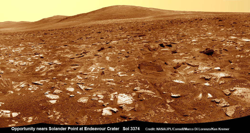
Opportunity rover’s view from very near the foothills of Solander Point looking along the rim and vast expanse of Endeavour Crater. Solander Point is the 1st Martian Mountain NASA’s Opportunity will climb and the rovers next destination. Solander Point may harbor clay minerals indicative of a past Martian habitable environment. This navcam mosaic was assembled from raw images taken on Sol 3374 (July 21, 2013). Credit: NASA/JPL/Cornell/Marco Di Lorenzo/Ken Kremer (kenkremer.com) See complete panoramic mosaic below

Opportunity rover’s view from very near the foothills of Solander Point looking along the rim and vast expanse of Endeavour Crater. This area exhibits gypsum signatures and numerous blocks of intriguing rock. Solander Point is the 1st Martian Mountain NASA’s Opportunity will climb and the rovers next destination. Solander Point may harbor clay minerals indicative of a past Martian habitable environment. This navcam mosaic was assembled from raw images taken on Sol 3374 (July 21, 2013). Credit: NASA/JPL/Cornell/Marco Di Lorenzo/Ken Kremer (kenkremer.com).
See complete panoramic mosaic below. Story updated with further details[/caption]

Exactly a decade after blasting off for the Red Planet and discovering a wide swath of water altered rocks and minerals in the ensuing years by exploring countless craters large and small, NASA’s intrepid Opportunity rover is just days away from arriving at her next big quest – a Martian mountain named Solander Point that may possess the key chemical ingredients necessary to sustain Martian life forms.

“We are parked 200 meters away from the bench at Solander Point,” Ray Arvidson told Universe Today exclusively. Arvidson is the mission’s deputy principal scientific investigator from Washington University in St. Louis, Mo. Furthermore, this area exhibits signatures related to water flow.

Solander Point also represents ‘something completely different’ – the first mountain the intrepid robot will ever climb.

“This will be Opportunity’s first mountain and the view from the ridge crest should be spectacular,” wrote Larry Crumpler, a science team member from the New Mexico Museum of Natural History & Science, in his latest field report about the 10 years ongoing Mars Exploration Rover (MER) mission.

Indeed the rover is now just a few short drives southward from making landfall on the northern tip of the point in her current trek across the relatively flat plains around the rim of Endeavour crater.

“We are now only about 180 meters from the new mountain, Solander Point.”

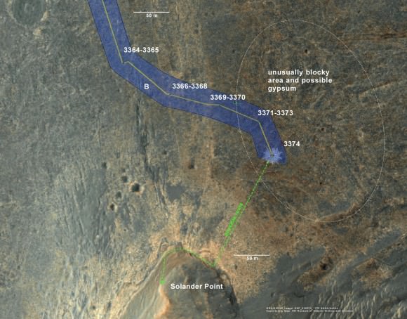
Opportunity rover location in the latest MRO/HiRISE color image. The green line shows more or less the route we hope to take to the base of Solander point. Since it is only a couple of hundred meters away, we could be there is a couple of drives. Maybe by the end of next week. The label say "3374" but this is also roughly the location through 3379.
Opportunity rover location in the latest MRO/HiRISE color image. The green line shows more or less the route we hope to take to the base of Solander point. Since it is only a couple of hundred meters away, the rover could be there is a couple of drives. Maybe by the end of next week. The label say “3374” but this is also roughly the location through 3379. NASA/JPL/Larry Crumpler

But before moving onward, Arvidson explained that the rover will briefly pause here “at dark terrain” for some exciting science due to water related spectral observations from the CRISM instrument captured by NASA’s Mars Reconnaissance Orbiter (MRO) circling overhead.

“CRISM data [from Mars orbit] shows a relatively deep 1.9 micrometer absorption feature due to H2O-bearing minerals,” said Arvidson.

This past spring, Opportunity made the historic discovery of clay minerals and a habitable environment on a low hill called Cape York at the rover’s prior stop along the rim of Endeavour crater.

Solander was selected as the robot’s next destination because it simultaneously offers a goldmine of science as well as north facing slopes – where Opportunity’s solar wings can more effectively soak up the sun’s rays to generate life giving electrical power during the next Martian winter.

But since Opportunity is currently generating plenty of power from her solar arrays and arriving with a bonus cushion of time before the looming onset of her 6th Martian winter, the team decided to take a small detour to the southeast and spend several sols (or Martian days) exploring an area of intriguing geology of outcrops, gypsum signatures and more on the bench surrounding the base of the mountain.

“We slowed down this week so that we could check out the rocks here where there is a strange hydration signature from orbital remote sensing,” says Crumpler.

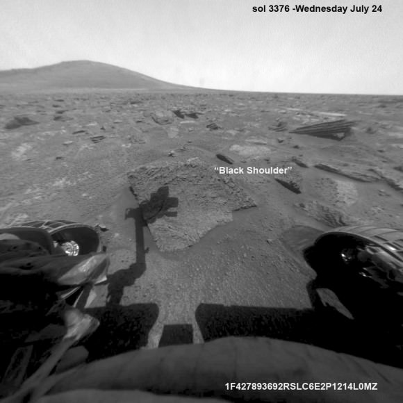
“This is also an area that appears to have more large blocks in the HiRISE images [from Mars orbit], so we are checking out one of the blocks, “Black Shoulder”.

“We are hoping that the rocks on the ridge crest will be spectacular too,” notes Crumpler.

Opportunity rover’s view very near the foothills of Solander Point along the rim and vast expanse of Endeavour Crater.  Solander Point is the 1st Martian Mountain NASA’s Opportunity will climb and the rovers next destination. Solander Point may harbor clay minerals indicative of a past Martian habitable environment. This navcam panoramic mosaic was assembled from raw images taken on Sol 3374 (July 21, 2013).  Credit: NASA/JPL/Cornell/Marco Di Lorenzo/Ken Kremer (kenkremer.com)
Opportunity rover’s view very near the foothills of Solander Point along the rim and vast expanse of Endeavour Crater. This area exhibits gypsum signatures and numerous blocks of intriguing rock. Solander Point is the 1st Martian Mountain NASA’s Opportunity will climb and the rovers next destination. Solander Point may harbor clay minerals indicative of a past Martian habitable environment. This navcam panoramic mosaic was assembled from raw images taken on Sol 3374 (July 21, 2013). Credit: NASA/JPL/Cornell/Marco Di Lorenzo/Ken Kremer (kenkremer.com)

Opportunity is using the science instruments on her 3 foot ( 1 meter) long robotic arm to conduct brief in-situ investigations of “Black Shoulder” with the Microscopic Imager (MI) and the Alpha Particle X-ray Spectrometer (APXS).

And …. it’s ‘Mountains Galore’ from here on out for the remainder of Opportunity’s Magnificent Mission to Mars.

Why? Because Opportunity is nearing the foothills of a long chain of eroded segments of the crater wall of Endeavour crater which spans a humongous 14 miles (22 kilometers) wide.

Solander Point may harbor deposits of phyllosilicate clay minerals – which form in neutral pH water – in a thick layer of rock stacks indicative of a past Martian habitable zone.

The rover team is discussing the best way to approach and drive up Solander.

“One idea is to drive part way up Solander from the west side of the rim, turn left and then drive down the steeper north facing slopes with the stratographic sections,” Ray Arvidson explained to Universe Today.

“That way we don’t have to drive up the relatively steeper slopes.”

“The rover can drive up rocky surfaces inclined about 12 to 15 degrees.”

“We want to go through the stratographic sections on the north facing sections,” Arvidson told me.

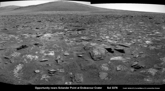
Opportunity rover moves closer to the foothills of Solander Point along the rim and vast expanse of Endeavour Crater.  The rover investigated one of the large rocks here with her microscopic imager and X-Ray spectrometer. Soon she will start climbing up Solander -  her 1st Martian Mountain ascent.  This navcam panoramic mosaic was assembled from raw images taken on Sol 3376 (July 23, 2013).  Credit: NASA/JPL/Cornell/Marco Di Lorenzo/Ken Kremer (kenkremer.com)
Opportunity rover moves closer to the foothills of Solander Point along the rim and vast expanse of Endeavour Crater. The rover investigated one of the large rocks near here with her microscopic imager and X-Ray spectrometer. Soon she will start climbing up Solander – her 1st Martian Mountain ascent. This navcam panoramic mosaic was assembled from raw images taken on Sol 3376 (July 23, 2013).
Credit: NASA/JPL/Cornell/Marco Di Lorenzo/Ken Kremer (kenkremer.com)

Today (July 28) is Sol 3380 for a mission that was only warrantied to last 90 Sols!

Opportunity’s total driving distance exceeds 23.6 miles (37.9 kilometers). She has snapped over 182,000 images.

The "work volume". This view from the front hazcams shows the rock target that is being checked out before the final slog to the south. With luck, by the end of next week we will be plinking around the base of yonder mountain. "Plinking" is a geological term for wandering around with your hammer trying to get a handle on the local outcrops before plunging ahead with mapping and asking the rocks serious questions.  Credit: NASA/JPL/Larry Crumpler
The “work volume”. This view from the front hazcams shows the rock target that is being checked out before the final slog to the south. With luck, by the end of next week we will be plinking around the base of yonder mountain. “Plinking” is a geological term for wandering around with your hammer trying to get a handle on the local outcrops before plunging ahead with mapping and asking the rocks serious questions. Credit: NASA/JPL/Larry Crumpler

Meanwhile on the opposite side of Mars at Gale Crater, Opportunity’s younger sister rover Curiosity also discovered a habitable environment originating from a time when the Red Planet was far warmer and wetter billions of years ago.

And like Opportunity, Curiosity is also trekking towards a mountain rich in sedimentary layers hoping to unveil the mysteries of Mars past. But Curiosity likely won’t arrive at 3.4 mile (5.5 km) high Mount Sharp for another year.

Ken Kremer

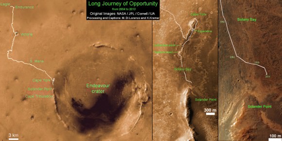
Traverse Map for NASA’s Opportunity rover from 2004 to 2013.  This map shows the entire path the rover has driven during more than 9 years and over 3374 Sols, or Martian days, since landing inside Eagle Crater on Jan 24, 2004 to current location near foothills of Solander Point at the western rim of Endeavour Crater.  Credit: NASA/JPL/Cornell/ASU/Marco Di Lorenzo/Ken Kremer
Traverse Map for NASA’s Opportunity rover from 2004 to 2013
This map shows the entire path the rover has driven during more than 9 years and over 3374 Sols, or Martian days, since landing inside Eagle Crater on Jan 24, 2004 to current location near foothills of Solander Point at the western rim of Endeavour Crater. Opportunity discovered clay minerals at Esperance – indicative of a habitable zone. Credit: NASA/JPL/Cornell/ASU/Marco Di Lorenzo/Ken Kremer

…………….
Learn more about Mars, Curiosity, Opportunity, LADEE, MAVEN, Antares and more at Ken’s upcoming lecture presentations

Aug 12: “RockSat-X Suborbital Launch, LADEE Lunar & Antares Rocket Launches from Virginia”; Rodeway Inn, Chincoteague, VA, 8 PM