NOAA/NASA/USAF Deep Space Climate Observatory (DSCOVR) Launching Feb. 8 to Monitor Solar Winds

DSCOVR mission logo. Credit: NOAA/NASA/U.S. Air Force

The long awaited Deep Space Climate Observatory, or DSCOVR science satellite is slated to blast off atop a SpaceX Falcon 9 on Sunday, Feb. 8, from Cape Canaveral, Florida on a mission to monitor the solar wind and aid very important forecasts of space weather at Earth.

DSCOVR is a joint mission between NOAA, NASA, and the U.S Air Force (USAF) that will be managed by NOAA. The satellite and science instruments are provided by NASA and NOAA.

Update Feb 8: Hold, Hold, Hold !!! 6:10 PM 2/8/15 Terminal Count aborted at T Minus 2 min 26 sec due to a tracking issue. NO launch of Falcon 9 today. rocket being safed now. next launch opportunity is Monday. Still TBD.

The rocket is provided by the USAF. SpaceX will try to recover the first stage via a guided descent to a floating barge in the Atlantic Ocean.

The weather outlook is currently very promising with a greater than 90 percent chance of favorable weather at launch time shortly after sunset on Sunday which could make for a spectacular viewing opportunity for spectators surrounding the Florida Space coast.

Liftoff atop the SpaceX Falcon 9 rocket is targeted for at 6:10:12 p.m. EST on Feb. 8, from Cape Canaveral Air Force Station Space Launch Complex 40.

There is an instantaneous launch window, meaning that any launch delay due to weather, technical or other factors will force a scrub to Monday.

The launch will be broadcast live on NASA TV: http://www.nasa.gov/nasatv

NASA’s DSCOVR launch blog coverage of countdown and liftoff will begin at 3:30 p.m. Sunday.
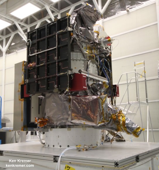
NOAA/NASA Deep Space Climate Observatory (DSCOVR) undergoes processing in NASA Goddard Space Flight Center clean room. Solar wind instruments at right. DSCOVER will launch in February 2015 atop SpaceX Falcon 9 rocket.  Credit: Ken Kremer/kenkremer.com/AmericaSpace
NOAA/NASA Deep Space Climate Observatory (DSCOVR) undergoes processing in NASA Goddard Space Flight Center clean room. Solar wind instruments at right. DSCOVER will launch in February 2015 atop SpaceX Falcon 9 rocket. Credit: Ken Kremer/kenkremer.com/AmericaSpace

“DSCOVR is NOAA’s first operational space weather mission to deep space,” said Stephen Volz, assistant administrator of the NOAA Satellite and Information Service in Silver Spring, Maryland, at the pre-launch briefing today (Feb. 7) at the Kennedy Space Center in Florida.

The mission of DSCOVR is vital because its solar wind observations are crucial to maintaining accurate space weather forecasts to protect US infrastructure from disruption by approaching solar storms.

“DSCOVR will maintain the nation’s solar wind observations, which are critical to the accuracy and lead time of NOAA’s space weather alerts, forecasts, and warnings,” according to a NASA description.

“Space weather events like geomagnetic storms caused by changes in solar wind can affect public infrastructure systems, including power grids, telecommunications systems, and aircraft avionics.”

DSCOVR will replace NASA’s aging Advanced Composition Explorer (ACE) satellite which is nearly 20 years old and far beyond its original design lifetime.

The couch sized probe is being targeted to the L1 Lagrange Point, a neutral gravity point that lies on the direct line between Earth and the sun located 1.5 million kilometers (932,000 miles) sunward from Earth. At L1 the gravity between the sun and Earth is perfectly balanced and the satellite will orbit about that spot just like a planet.

L1 is a perfect place for the science because it lies outside Earth’s magnetic environment. The probe will measure the constant stream of solar wind particles from the sun as they pass by.
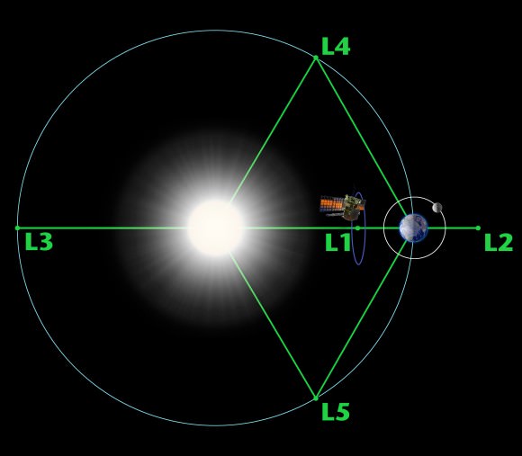
Diagram of the five Lagrange points associated with the sun-Earth system, showing DSCOVR orbiting the L-1 point. Image is not to scale.  Credit:  NASA/WMAP Science Team
Diagram of the five Lagrange points associated with the sun-Earth system, showing DSCOVR orbiting the L-1 point. Image is not to scale. Credit: NASA/WMAP Science Team

This will enable forecasters to give a 15 to 60 minute warning of approaching geomagnetic storms that could damage valuable infrastructure.

DSCOVR is equipped with a suite of four continuously operating solar science and Earth science instruments from NASA and NOAA.

It will make simultaneous scientific observations of the solar wind and the entire sunlit side of Earth.

Three instruments will help measure the solar wind on the DSCOVR mission: (shown from left to right), the Faraday cup to monitor the speed and direction of positively-charged solar wind particles, the electron spectrometer to monitor electrons, and a magnetometer to measure magnetic fields.  Credit: NASA/DSCOVR
Three instruments will help measure the solar wind on the DSCOVR mission: (shown from left to right), the Faraday cup to monitor the speed and direction of positively-charged solar wind particles, the electron spectrometer to monitor electrons, and a magnetometer to measure magnetic fields. Credit: NASA/DSCOVR

The 750-kilogram DSCOVR probe measures 54 inches by 72 inches.

I saw the DSCOVR spacecraft up close at NASA Goddard Space Flight Center in Maryland last fall during processing in the clean room.
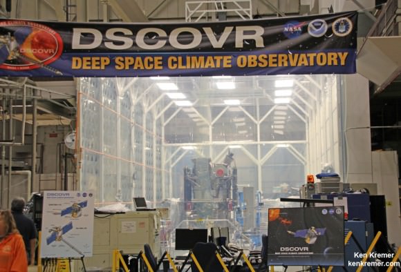
NOAA/NASA/USAF Deep Space Climate Observatory (DSCOVR) undergoes processing in NASA Goddard Space Flight Center clean room.  Probe will launch in February atop SpaceX Falcon 9 rocket.  Credit: Ken Kremer - kenkremer.com
NOAA/NASA/USAF Deep Space Climate Observatory (DSCOVR) undergoes processing in NASA Goddard Space Flight Center clean room. Probe will launch in February atop SpaceX Falcon 9 rocket. Credit: Ken Kremer – kenkremer.com

A secondary objective of the rocket launch for SpaceX is to conduct their second attempt to recover the Falcon 9 first stage booster on an ocean going barge. Read my articles about the first attempt in January 2015, starting here.

It was originally named ‘Triana’ (aka Goresat) and was conceived by then US Vice President Al Gore as a low cost satellite to take near continuous views of the Earth’s entire globe to feed to the internet as a means of motivating students to study math and science. It was eventually built as a much more capable Earth science satellite as well as to conduct the space weather observations.

But Triana was shelved for purely partisan political reasons and the satellite was placed into storage and the science was lost until now.

Stay tuned here for Ken’s continuing Earth and planetary science and human spaceflight news.
Ken Kremer

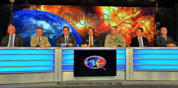
The team is ready for the launch of NASA's DSCOVR spacecraft aboard a SpaceX Falcon 9 rocket. L/R Mike Curie KSC NASA News Chief, Stephen Volz, assistant administrator NOAA, Tom Berger, director of NOAA Space Weather Prediction Center Boulder Colorado,Steven Clark, NASA Joint Agency Satellite Division, Col. D. Jason Cothern, Space Demonstration Division chief at Kirkland AFB NM. Hans Koenigsmann, VP of mission assurance at SpaceX in Hawthorne, California, Mike McAlaneen, launch weather officer 45th Space wing Cape Canaveral Air Force Station, Florida.  Credit: Julian Leek
The team is ready for the launch of NASA’s DSCOVR spacecraft aboard a SpaceX Falcon 9 rocket. L/R Mike Curie KSC NASA News Chief, Stephen Volz, assistant administrator NOAA, Tom Berger, director of NOAA Space Weather Prediction Center Boulder Colorado,Steven Clark, NASA Joint Agency Satellite Division, Col. D. Jason Cothern, Space Demonstration Division chief at Kirkland AFB NM. Hans Koenigsmann, VP of mission assurance at SpaceX in Hawthorne, California, Mike McAlaneen, launch weather officer 45th Space wing Cape Canaveral Air Force Station, Florida. Credit: Julian Leek

You’ve Never Seen the Phases of the Moon from This Perspective: The Far Side

Credit

Sometimes, it seems to be a cosmic misfortune that we only get to view the universe from a singular vantage point.

Take the example of our single natural satellite. As the Moon waxes and wanes through its cycle of phases,  we see the familiar face of the lunar nearside. This holds true from the day we’re born until the day we die. The Romans and Paleolithic man saw that same face, and until less than a century ago, it was anyone’s guess as to just what was on the other side.

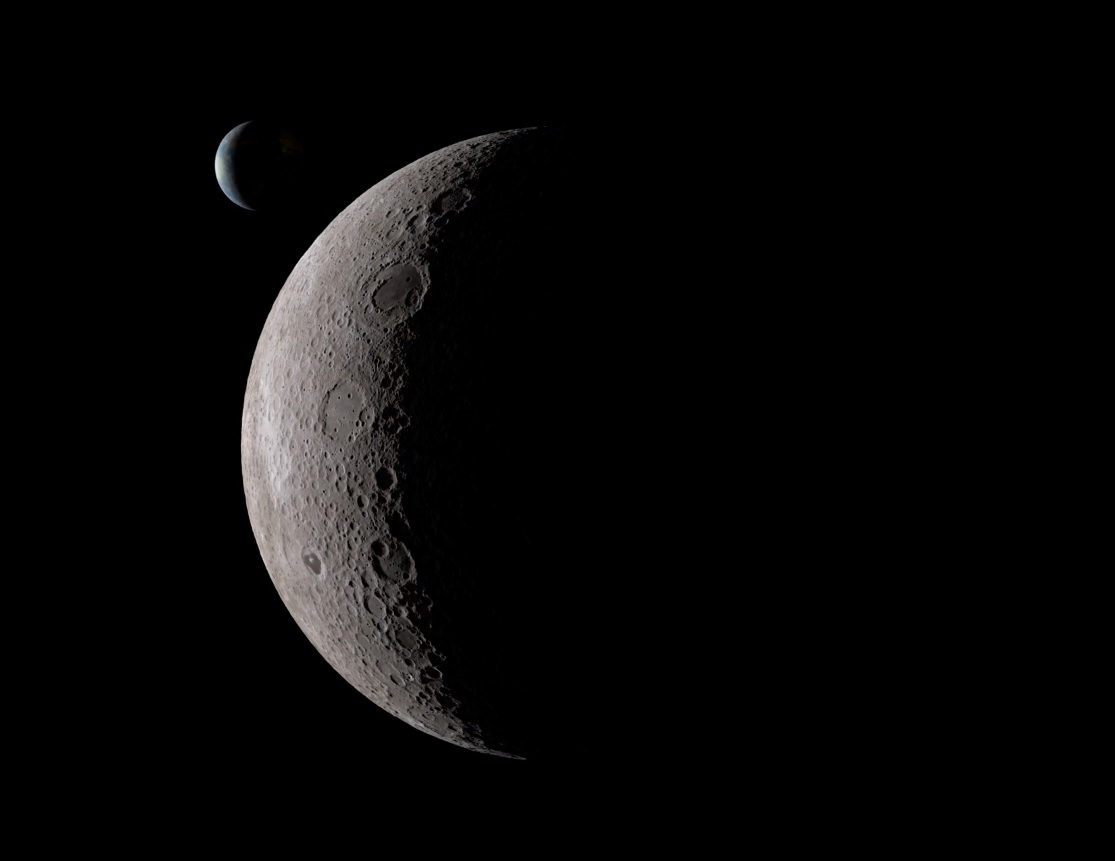
Enter the Space Age and the possibility to finally get a peek at the universe from different perspective via our robotic ambassadors. This week, the folks over at NASA’s Scientific Visualization Studio released a unique video simulation that utilized data from NASA’s Lunar Reconnaissance Orbiter to give us a view unseen from Earth. This perspective shows just what the phases of the Moon would look like from the vantage point of the lunar farside:

You can see the Moon going through the synodic 29.5 day period a familiar phases, albeit with an unfamiliar face. Note that the Sun zips by, as the lunar farside wanes towards New. And in the background, the Earth can be seen, presenting an identical phase and tracing out a lazy figure eight as it appears and disappears behind the lunar limb.

Credit
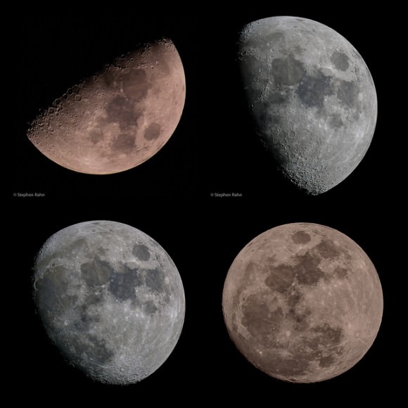
The lunar nearside: A familiar view. Credit: Stephen Rahn.

What’s with the lunar-planetary game of peek-a-boo? Well, the point of view for the video assumes that your looking at down at the lunar farside from a stationary point above the Moon. Note that the disk of the Moon stays fixed in place. The Moon actually ‘rocks’ or nods back and forth and side-to-side in motions referred to as libration and nutation, and you’re seeing these expressed via the motion of the Earth in the video.  This assures that we actually get a peek over the lunar limb and see a foreshadowed extra bit of the lunar farside, with grand 59% of the lunar surface visible from the Earth. Such is the wacky motion of our Moon, which gave early astronomers an excellent crash course in celestial mechanics 101.

Now, to dispel some commonly overheard lunar myths:

Myth #1: The moon doesn’t rotate. Yes, it’s tidally locked from our perspective, meaning that it keeps one face turned Earthward. But it does turn on its axis in lockstep as it does so once every 27.3 days, known as a sidereal month.

Myth #2:  The Farside vs. the Darkside. (Cue Pink Floyd) We do in fact see the dark or nighttime side of the Moon just as much as the daytime side. Despite popular culture, the farside is only synonymous with the darkside of the Moon during Full phase.

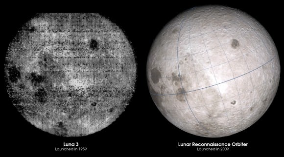
Humanity got its first glimpse of the lunar farside in 1959, when the Soviet Union’s Luna 3 spacecraft looked back as it flew past the Moon and beamed us the first blurry image. The Russians got there first, which is why the lunar farside now possesses names for features such as the “Mare Moscoviense”.

Credit
Our evolving view of the lunar farside over 60 years… Credit: NASA/LRO.

Think we’ve explored the Moon? Thus far, no mission – crewed or otherwise – has landed on the lunar farside. The Apollo missions were restricted to nearside landing sites at low latitudes with direct line of sight communication with the Earth. The same goes for the lunar poles: the Moon is still a place begging for further exploration.

Credit
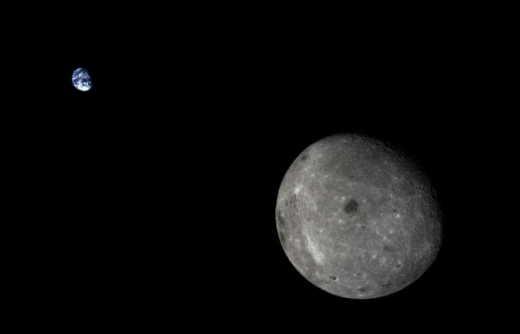
China’s Chang’e 5 T1 pathfinder mission looks back at the Earth and the lunar farside. Credit: Xinhua/SASTIND.

Why go to the lunar farside? Well, it would be a great place to do some radio astronomy, as you have the bulk of the Moon behind you to shield your sensitive searches from the now radio noisy Earth. Sure, the dilemmas of living on the lunar farside might forever outweigh the benefits, and abrasive lunar dust will definitely be a challenge to lunar living… perhaps an orbiting radio astronomy observatory in a Lissajous orbit at the L2 point would be a better bet?

Credit
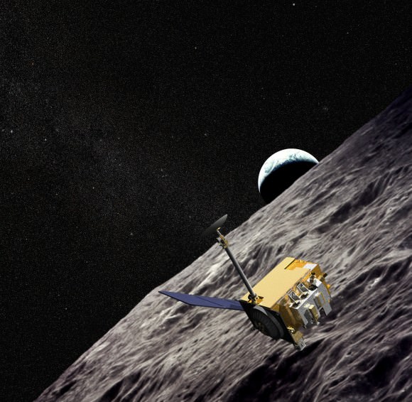
An artist’s conception of LRO in lunar orbit. Credit: NASA/LRO.

And exploration of the Moon continues. Earlier this week, the LRO team released a finding suggesting that surface hydrogen may be more abundant on the poleward facing slopes of craters that litter the lunar south pole region. Locating caches of lunar ice in permanently shadowed craters will be key to a ‘living off of the land’ approach for future lunar colonists… and then there’s the idea to harvest helium-3 for nuclear fusion (remember the movie Moon?) that’s still science fiction… for now.

Perhaps the Moonbase Alpha of Space: 1999 never came to pass… but there’s always 2029!

This is What War (and Borders) Look Like From Space

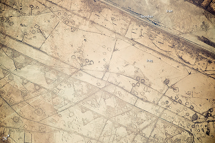
This image, taken by astronauts on the International Space Station on Nov. 7, 2014, shows patterns of fortification along the Iraq-Iran border. Credit: NASA/Expedition 41.

There’s an oft-used idiom that you can’t see political borders from space, but we’ve known for a while it’s no longer true. Between higher resolution cameras and the increase in human activity, there have been several examples of borders visible from space. Here’s one more.

Astronauts aboard the International Space Station took this photograph in November of 2014 of a 20-kilometer (12-mile) stretch of the Iraq-Iran border, near the coast of the Persian Gulf. Clearly visible is the border between the two countries, along with signs of fortification: circular gun emplacements, systems of large curved earthworks and straight connecting roads that run parallel to the border.

NASA said the ISS team that analyzes astronaut photos first thought the circular features to be oil-pad installations (like ones seen in Texas here). But they said the “strategic location of these formations along the international boundary made it easier to see these as patterns of military fortifications. This region of oil refining and exporting was the center of numerous military actions during the war in the 1980s, especially during the defense of the southern city of Basra.”

Back in 2011, we featured an image from astronaut Ron Garan which clearly showed the human-made border between India and Pakistan. Since 2003, India has illuminated the border with Pakistan by floodlights in attempt to prevent ammunition trafficking and the infiltration of terrorists.

This picture shows the illuminated man-made border between India and Pakistan,the line snaking through the landscape, as seen from the International Space Station on August 21, 2011. Of the hundreds of clusters lights, the largest are the capital cities of Islamabad, Pakistan, and New Delhi, India. Credit: NASA/Ron Garan

“Realizing what this picture depicted had a big impact on me,” Garan said. “When viewed from space, Earth almost always looks beautiful and peaceful. However, this picture is an example of man-made changes to the landscape in response to a threat, clearly visible from space. This was a big surprise to me.”

There’s also a satellite photo from the M-Sat Planet Observer showing the clear border and demilitarized zone between North and South Korea.

Korean Peninsula at night, satellite image shows a contrast (and border) between North and South Korea, Credit: PlanetObserver/Science Photo Library.

Sources: NASA, Fragile Oasis, M-Sat Planet Observer

NASA Launches Revolutionary Earth Science Satellite Measuring Soil Moisture Cycle

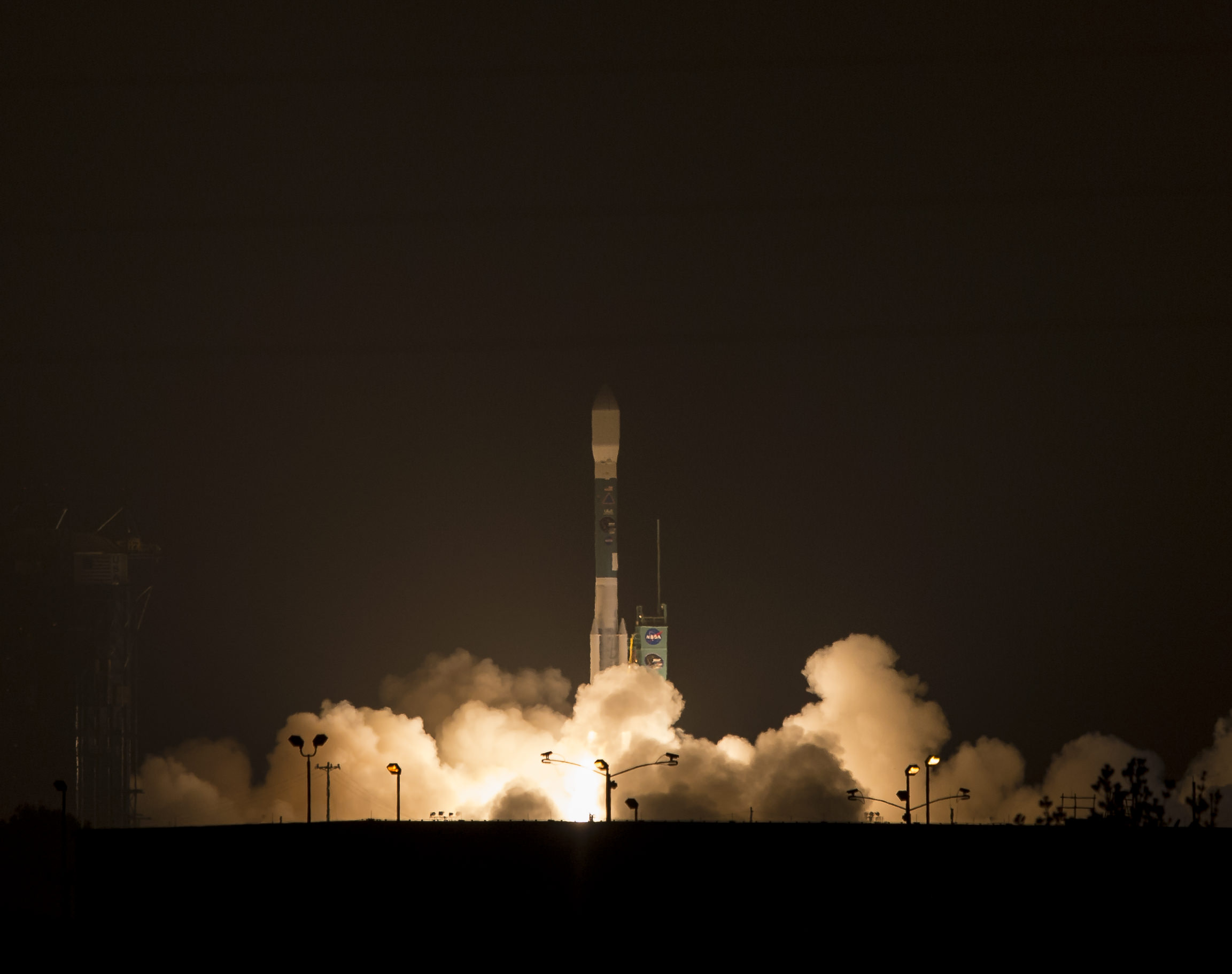
NASA's Soil Moisture Active Passive (SMAP) observatory, on a United Launch Alliance Delta II rocket, is seen after the mobile service tower was rolled back Friday, Jan. 30 at Space Launch Complex 2, Vandenberg Air Force Base, Calif. Image Credit: NASA/Bill Ingalls

NASA’s Soil Moisture Active Passive (SMAP) observatory, on a United Launch Alliance Delta II rocket, is seen after the mobile service tower was rolled back Friday, Jan. 30 at Space Launch Complex 2, Vandenberg Air Force Base, Calif.
Image Credit: NASA/Bill Ingalls
Story updated[/caption]

At dawn this morning (Jan. 31) NASA launched an advanced Earth science satellite aimed at making measurements of our planet’s surface soil moisture and freeze/thaw states from space that will revolutionize our understanding of the water, energy, and carbon cycles driving all life on Earth, aid weather forecasting and improve climate change models.

NASA’s new Soil Moisture Active Passive (SMAP) observatory thundered off the pad at 6:22 a.m. PST (9:22 a.m. EST) Saturday atop a two stage United Launch Alliance Delta II rocket from Space Launch Complex 2 on Vandenberg Air Force Base, California.

The $916 million satellite successfully separated from the rocket’s second stage some 57 minutes after the flawless liftoff and was injected into an initial 411- by 425-mile (661- by 685-kilometer) orbit. The spacecraft then deployed its solar arrays and telemetry indicated it was in excellent health.

“We’re in contact with SMAP and everything looks good right now,” NASA Launch Manager Tim Dunn said.

“Deployment of the solar arrays is underway. We just couldn’t be happier.”

SMAP separated from the second stage while pointed toward the sun as seen in the video below from a rocket mounted camera:

Video Caption: A camera on the second stage of the Delta II rocket captured this footage as the SMAP spacecraft pushed itself away from the rocket to complete the delivery of the Earth-observing spacecraft to its proper orbit following Jan. 31, 2015 liftoff. Credit: NASA TV/ULA

SMAP is NASA’s 1st Earth observing satellite designed to make high resolution global observations of Earth’s vital surface soil moisture content and freeze/thaw cycle just below your feet. It will aid global forecasting and have broad applications for science and society.

SMAP’s combined radar and radiometer instruments will peer into the top 2 inches (5 centimeters) of soil, through clouds and moderate vegetation cover, day and night, to produce the highest-resolution, most accurate soil moisture maps ever obtained from space, says NASA.

The blastoff of SMAP successfully concluded NASA’s ambitious plans to launch a record breaking total of five Earth science satellites in less than a year’s time.

“The launch of SMAP completes an ambitious 11-month period for NASA that has seen the launch of five new Earth-observing space missions to help us better understand our changing planet,” said NASA Administrator Charles Bolden.

“Scientists and policymakers will use SMAP data to track water movement around our planet and make more informed decisions in critical areas like agriculture and water resources.”

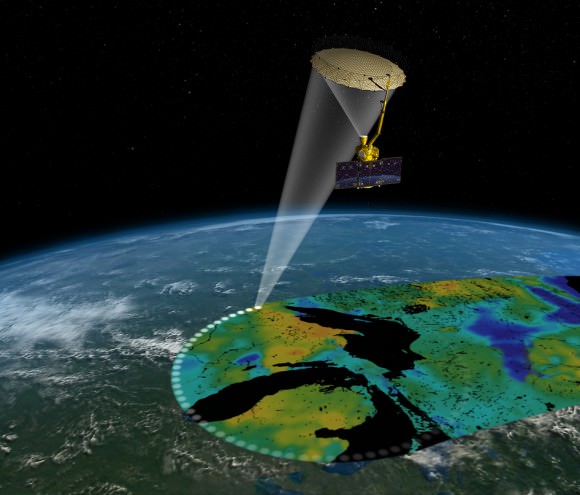
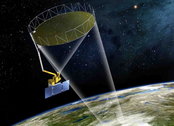
Artist's rendering of the Soil Moisture Active Passive satellite. The width of the region scanned on Earth’s surface during each orbit is about 620 miles (1,000 kilometers).  Image credit: NASA/JPL-Caltech
Artist’s rendering of the Soil Moisture Active Passive satellite. The width of the region scanned on Earth’s surface during each orbit is about 620 miles (1,000 kilometers). Image credit: NASA/JPL-Caltech

SMAP is projected to last for at least a three year primary mission.

The prior NASA Earth science instrument launched was the Cloud Aerosol Transport System (CATS) payload hauled to space by the SpaceX CRS-4 Dragon on Jan. 10, 2015 and recently installed on the exterior of the ISS. Read my CATS installation story – here.

The three earlier NASA Earth science missions launched over the past year included ISS-RapidScat in September 2014, the Global Precipitation Measurement (GPM) Core Observatory, a joint mission with the Japan Aerospace Exploration Agency, in February 2014, and the Orbiting Carbon Observatory-2 (OCO-2) carbon observatory in July 2014.

“Congratulations to the NASA Launch Services Program team, JPL and all of our mission partners on today’s successful launch of the SMAP satellite,” said Jim Sponnick, ULA vice president, Atlas and Delta Programs.

“It is our honor to launch this important Earth science mission to help scientists observe and predict natural hazards, and improve our understanding of Earth’s water, energy and carbon cycles.”

SMAP will provide high-resolution, space-based measurements of soil moisture and its state — frozen or thawed — a new capability that will allow scientists to better predict natural hazards of extreme weather, climate change, floods and droughts, and help reduce uncertainties in our understanding of Earth’s water, energy and carbon cycles, according to a NASA description.

The mission will map the entire globe every two to three days for at least three years and provide the most accurate and highest-resolution maps of soil moisture ever obtained. The spacecraft’s final circular polar orbit will be 426 miles (685 kilometers), at an inclination of 98.1 degrees. The spacecraft will orbit Earth once every 98.5 minutes and repeat the same ground track every eight days.

“All subsystems are being powered on and checked out as planned,” Kent Kellogg, the SMAP project manager, during a post-launch press conference.

“Communications, guidance and control, computers and power are all operating nominally.”

The observatory is in excellent health. Its instruments will be turned on in 11 days.

Today’s blastoff of SMAP marks ULA’s second successful launch this month as well as the second of 13 planned for 2015. ULA’s first launch of 2015 was MUOS-3 from Cape Canaveral on Jan. 20.

ULA’s next launch involves NASA’s Magnetospheric Multiscale Mission (MMS) to study Earth’s magnetic reconnection. It is scheduled for launch on an Atlas V 421 booster on March 12 from Cape Canaveral. See my up close visit with MMS and NASA Administrator Charles Bolden at NASA Goddard Space Flight Center detailed in my story – here.

Stay tuned here for Ken’s continuing Earth and planetary science and human spaceflight news.

Ken Kremer

NASA and NOAA Satellites Image Crippling Blizzard of 2015 Pounding New England

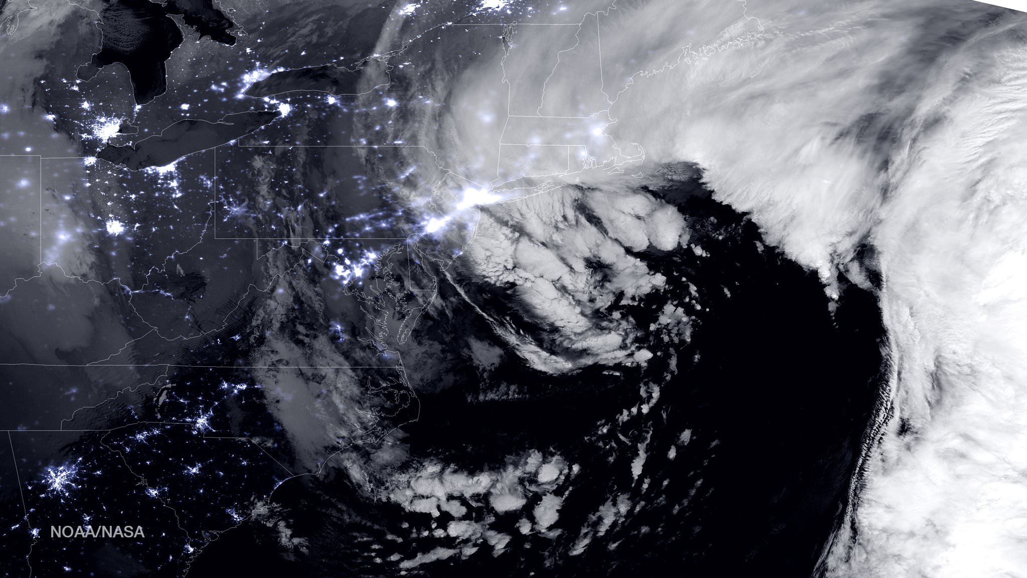
NASA-NOAA Suomi NPP satellite captures blizzard near peak intensity as it moves over New York and Boston regions at 1:45 am EST, Jan. 27, 2015. This view is a combination of the day-night band and high resolution infrared imagery from Suomi NPP showing the historic blizzard near peak intensity as it moves over the New York through Boston Metropolitan areas at 06:45Z (1:45 a.m. EST) on January 27, 2015. Credit: NOAA/NASA

NEW JERSEY – Record breaking snow from the ‘Blizzard of 2015’ hit vast regions of the US Northeast today, Jan. 27, 2015, stretching from Long Island to New England.

NASA and NOAA Earth orbiting satellites are keeping track of the storm affecting millions of residents.

This afternoon the agencies provided a new set of night-time and daytime views of the Blizzard of 2015 taken by the Suomi NPP and the GOES-East satellites.

The crippling blizzard is causing misery, extensive destruction to homes and businesses in localized areas, power outages, traffic accidents, breaks in some sea walls and deaths.

The satellite image above shows a combination of the day-night band and high resolution infrared imagery from the NASA-NOAA’s Suomi NPP satellite.

It was taken as the historic blizzard neared peak intensity as it moved over the New York area and through the Boston Metropolitan areas at 06:45Z (1:45 a.m. EST) on January 27, 2015.

The high cloud tops from the most intense parts of the storm blurred the regions normally bright nighttime lights in the satellite image.

Although the snow totals were about half the over two feet forecast for the New York Metropolitan region, many areas to the north and east were inundated with very heavy to historic snow fall totals, as bad or worse than the forecasters predicted.

Over two feet of snow fell on areas of New York’s Long Island and stretching north to vast regions of Connecticut, Massachusetts, New Hampshire and into Maine.

Near hurricane force waves are crashing into some coastal towns along the Massachusetts shoreline. Wind gusts as high as 78 mph have been recorded.

“Highest snowfall report has been Auburn, MA with 32.5 inches! Wind gust reports as high as 78 mph in Nantucket, MA,” according to a tweet this evening from the National Weather Service (NWS).

Worchester, Mass had a record breaking 31 inches of snow. And it’s still falling this evening in the 2nd largest city in New England.

A flood emergency is in effect in Marshfield, Mass., where an 80 foot section of the seawall was smashed by crashing waves and is destroying homes as shown on NBC Nightly News.

Blinding snow is raging in Portland, Maine this evening according on a live NBC News report.

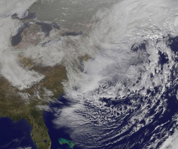
On January 27, 2015 at 17:35 UTC (12:35 p.m. EST) NOAA's Geostationary Operational Environmental or GOES- East satellite captured an image of the nor'easter over New England. Credit: NASA/NOAA GOES Project
On January 27, 2015 at 17:35 UTC (12:35 p.m. EST) NOAA’s Geostationary Operational Environmental or GOES- East satellite captured an image of the nor’easter over New England. Credit: NASA/NOAA GOES Project

“At 10 a.m. EST, the National Weather Service noted “the powerful nor’easter that brought moderate to heavy snowfall and blizzard conditions to the Northeast on Monday will continue to affect the region on Tuesday, with heavy snow and blizzard conditions expected from eastern Long Island to Maine as the system slowly moves to the northeast. Snow and strong winds will being tapering off from south to north Tuesday night into Wednesday morning,” wrote NASA’s Rob Gutro of NASA’s Goddard Space Flight Center in an update.

“Later on January 27, 2015 at 17:35 UTC (12:35 p.m. EST) NOAA’s Geostationary Operational Environmental or GOES-East satellite captured an image of the nor’easter over New England. The image was created by the NASA/NOAA GOES Project and showed the clouds associated with the nor’easter blanketing New England. An occluded front extended north and eastward out of the low pressure area’s center out into the Atlantic Ocean.”

The latest NOAA forecast as of 4 PM, Jan. 27 states:

HIGH WINDS AND HEAVY SNOW WILL BEGIN TO GRADUALLY TAPER OFF FROM SOUTH TO NORTH TONIGHT…BUT WILL LAST INTO EARLY WEDNESDAY MORNING ACROSS PORTIONS OF MAINE. HEAVY SNOWFALL WILL COMBINE WITH SUSTAINED WINDS OF 30 TO 40 MPH…AND GUSTS IN EXCESS OF 50 MPH…TO CREATE LIFE-THREATENING WHITEOUT OR BLIZZARD CONDITIONS. THESE WINDS MAY LEAD TO DOWNED TREES AND POWER LINES RESULTING IN POWER OUTAGES. TRAVEL WILL BE IMPOSSIBLE AND LIFE-THREATENING IN MANY AREAS. ALONG THE IMMEDIATE COASTLINE…WIND GUSTS TO NEAR 65 MPH WILL BE POSSIBLE. COASTAL FLOODING AND SEVERE BEACH EROSION WILL ALSO BE A POSSIBILITY…AND VULNERABLE ROADS AND STRUCTURES MAY BE FLOODED OR DAMAGED.

Stay tuned here for Ken’s continuing Earth and planetary science and human spaceflight news.
Reporting from snowy New Jersey.

Ken Kremer

CATS Out of The Bag, Crawling Around ISS for Science Down Below

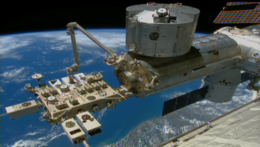
This video frame shows a robotic arm on the space station, called the Japanese Experiment Module Remote Manipulator System, successfully installing NASA's Cloud-Aerosol Transport System (CATS) to the Space Station’s Japanese Experiment Module on Jan. 22, 2015. Credit: NASA

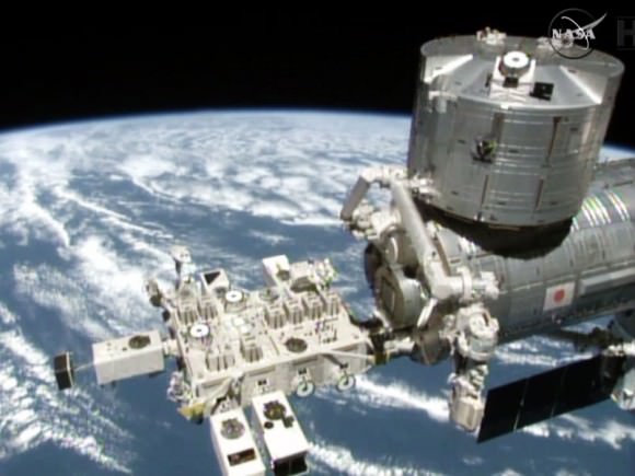
The Japanese robotic arm installs the CATS experiment on an external platform on Japan’s Kibo lab module. The SpaceX Dragon commercial cargo craft is seen at the right center of the image. Credit: NASA TV
See way cool installation video below[/caption]

“Robotic controllers let the CATS out of the bag!” So says NASA spokesman Dan Huot in a cool new NASA timelapse video showing in detail how CATS crawled around the space stations gangly exterior and clawed its way into its new home – topped off with a breathtaking view of our home planet that will deliver science benefits to us down below.

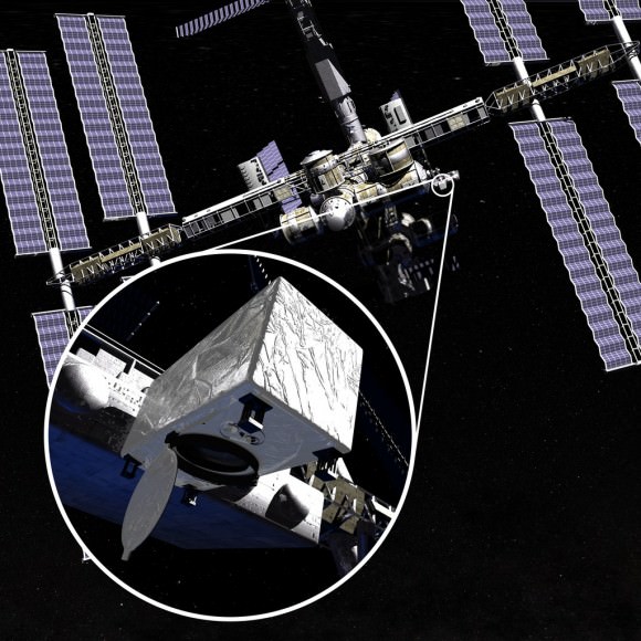
The CATS experiment was installed on the exterior of the International Space Station (ISS) via a first ever type of robotic handoff, whereby one of the stations robotic arms handed the rectangular shaped instrument off to a second robotic arm. Sort of like relays runners passing the baton while racing around the track for the gold medal.

In this case it was all in the name of science. CATS is short for Cloud Aerosol Transport System.

Ground controllers at NASA’s Johnson Space Center in Houston plucked CATS out of the truck of the recently arrived SpaceX Dragon cargo delivery vehicle with the Special Purpose Dexterous Manipulator (Dextre). Then they passed it off to a Japanese team of controllers at JAXA, manipulating the second arm known as the Japanese Experiment Module Remote Manipulator System. The JAXA team then installed CATS onto an external platform on Japans Kibo laboratory.

CATS is a new Earth Science instrument dedicated to collecting continuous data about clouds, volcanic ash plumes and tiny airborne particles that can help improve our understanding of aerosol and cloud interactions and improve the accuracy of climate change models.

The remote-sensing laser instrument measures clouds and the location and distribution of pollution, dust, smoke, and other particulates and aerosols in the atmosphere that directly impacts the global climate.

Data from CATS will be used to derive properties of cloud/aerosol layers at three wavelengths: 355, 532, 1064 nm.

Check out this cool NASA ‘Space to Ground’ video showing CATS installation

Video caption: NASA’s Space to Ground on 1/23/15 covers CATS Out of The Bag. This is your weekly update on what’s happening aboard the International Space Station. Got a question or comment? Use #spacetoground to talk to us.

All the movements were conducted overnight by robotic flight controllers on the ground. They installed CATS to an external platform on Japan’s Kibo lab module.

CATS is helping to open a new era on the space station research dedicated to expanding its use as a science platform for making extremely valuable remote sensing observations for Earth Science.

The CATS instrument is the fourth successful NASA Earth science launch out of five scheduled during a 12-month period. And it is the second to be installed on the exterior of the ISS, following ISS-RapidScat that was brought by the SpaceX CRS-4 Dragon.

The fifth launch — the Soil Moisture Active Passive satellite — is scheduled for Jan. 29 from Vandenberg Air Force Base in California.

CATS was launched to the station as part of the payload aboard the SpaceX Dragon CRS-5 cargo vessel bolted atop the SpaceX Falcon 9 for the spectacular nighttime blastoff on Jan. 10 at 4:47 a.m. EST from Cape Canaveral Air Force Station in Florida.

CATS was loaded in the unpressurized rear trunk section of Dragon.

Kibo Laboratory The new CATS experiment delivered by the SpaceX commercial cargo craft will be installed on a platform outside Japan’s Kibo Laboratory module. Credit: NASA
Kibo Laboratory
The new CATS experiment delivered by the SpaceX commercial cargo craft will be installed on a platform outside Japan’s Kibo Laboratory module. Credit: NASA

The Dragon CRS-5 spacecraft was loaded with over 5108 pounds (2317 kg) of scientific experiments, technology demonstrations, the CATS science payload, student research investigations, crew supplies, spare parts, food, water, clothing and assorted research gear for the six person crew serving aboard the ISS.

It successfully rendezvoused at the station on Jan. 12 after a two day orbital chase, delivering the critical cargo required to keep the station stocked and humming with science.

Artist concept of CATS on ISS. Credit: NASA

Stay tuned here for Ken’s continuing Earth and planetary science and human spaceflight news.
Ken Kremer

President Obama Salutes NASA, Astronaut Kelly, and 1 Year ISS Mission at State of the Union Address

NASA astronaut Scott Kelly stands as he is recognized by President Barack Obama, while First lady Michelle Obama, front left, and other guest applaud, during the State of the Union address on Capitol Hill in Washington, Tuesday Jan. 20, 2015. This March, Astronaut Scott Kelly will launch to the International Space Station and become the first American to live and work aboard the orbiting laboratory for a year-long mission. Credit: NASA/Bill Ingalls

President Obama gave a shout out to NASA Astronaut Scott Kelly and his upcoming 1 year mission to the International Space Station at the 2015 State of the Union address to the US Congress on Tuesday evening, Jan. 20, 2015.

Obama wished Kelly (pictured above in the blue jacket) good luck during his address and told him to send some photos from the ISS via Instagram. Kelly was seated with the First Lady, Michelle Obama, during the speech on Capitol Hill.

The TV cameras focused on Kelly and he was given a standing ovation by the Congress and the President.

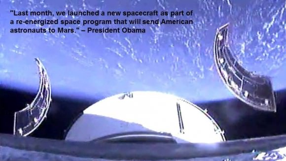
Obama also praised Kelly’s flight and the recent Dec. 5, 2014, launch of NASA’s Orion deep space capsule as “part of a re-energized space program that will send American astronauts to Mars.”

Watch this video of President Obama hailing NASA and Scott Kelly:


Video Caption: President Obama recognizes NASA and Astronaut Scott Kelly at 2015 State of the Union Address. Credit: Congress/NASA

Here’s a transcript of President Obama’s words about NASA, Orion, and Scott Kelly’s 1 Year ISS mission:

“Pushing out into the Solar System not just to visit, but to stay. Last month, we launched a new spacecraft as part of a re-energized space program that will send American astronauts to Mars. In two months, to prepare us for those missions, Scott Kelly will begin a year-long stay in space. Good luck, Captain and make sure to Instagram it.”

In late March, Astronaut Scott Kelly will launch to the International Space Station and become the first American to live and work aboard the orbiting laboratory for a year-long mission.

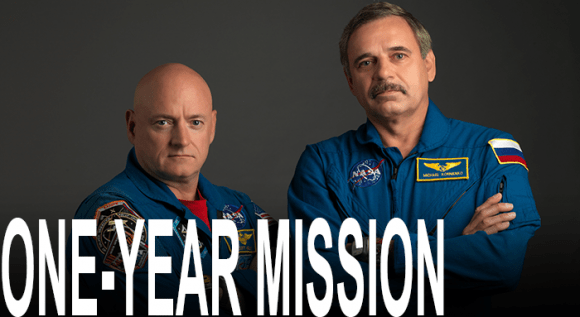
Scott Kelly and Russian Cosmonaut Mikhail Kornienko, both veteran spacefliers, comprise the two members of the 1 Year Mission crew.

Normal ISS stays last for about a six month duration.

NASA Astronaut Scott Kelly and Russian Cosmonaut Mikhail Kornienko comprise  the first ever ISS 1 Year Crew
NASA Astronaut Scott Kelly and Russian Cosmonaut Mikhail Kornienko comprise the first ever ISS 1 Year Crew

No American has ever spent anywhere near a year in space. 4 Russian cosmonauts conducted long duration stays of about a year or more in space aboard the Mir Space Station in the 1980s and 1990s.

Together with Russian cosmonaut Gennady Padalka, Kelly and Kornienko will launch on a Russian Soyuz capsule from the Baikonur Cosmodrome as part of Expedition 44.

Kelly and Kornienko will stay aboard the ISS until March 2016.

They will conduct hundreds of science experiments focusing on at least 7 broad areas of investigation including medical, psychological, and biomedical challenges faced by astronauts during long-duration space flight.

During the 2015 State of the Union Address on Jan 20, President Obama lauds NASA’s Orion Spacecraft and our "re-energized space program."  Credit: NASA
During the 2015 State of the Union Address on Jan 20, President Obama lauds NASA’s Orion Spacecraft and our “re-energized space program.” Credit: NASA

Kelly was just featured in a cover story at Time magazine.

Here’s an online link to the Time magazine story : http://ti.me/1w25Qgo

@TIME features @StationCDRKelly ‘s 1-year-long mission in it’s 2015: Year Ahead issue. http://ti.me/1w25Qgo
@TIME features @StationCDRKelly ‘s 1-year-long mission in its 2015: Year Ahead issue. http://ti.me/1w25Qgo

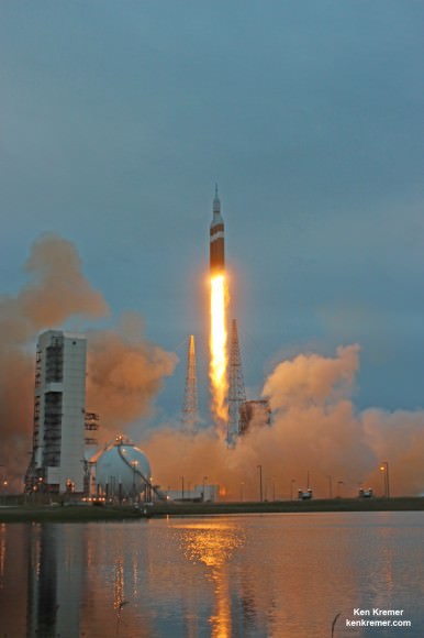
Orion flew a flawless inaugural test flight when it thundered to space on Dec. 5, 2014, atop the fiery fury of a 242 foot tall United Launch Alliance Delta IV Heavy rocket – the world’s most powerful booster – from Space Launch Complex 37 (SLC-37) at Cape Canaveral Air Force Station in Florida.

Orion launched on its two orbit, 4.5 hour flight maiden test flight on the Exploration Flight Test-1 (EFT-1) mission that carried the capsule farther away from Earth than any spacecraft designed for astronauts has traveled in more than four decades.

NASA’s first Orion spacecraft blasts off at 7:05 a.m. atop United Launch Alliance Delta 4 Heavy Booster at Space Launch Complex 37 (SLC-37) at Cape Canaveral Air Force Station in Florida on Dec. 5, 2014.   Launch pad remote camera view.   Credit: Ken Kremer - kenkremer.com
NASA’s first Orion spacecraft blasts off at 7:05 a.m. atop United Launch Alliance Delta 4 Heavy Booster at Space Launch Complex 37 (SLC-37) at Cape Canaveral Air Force Station in Florida on Dec. 5, 2014. Launch pad remote camera view. Credit: Ken Kremer – kenkremer.com

Kelly’s flight will pave the way for NASA’s goal to send astronaut crews to Mars by the 2030s. They will launch in the Orion crew vehicle atop the agency’s mammoth new Space Launch System (SLS) rocket, simultaneously under development.

Good luck to Kelly and Kornienko!!

NASA Administrator Charles Bolden officially unveils world’s largest welder to start construction of core stage of NASA's Space Launch System (SLS) rocket at NASA Michoud Assembly Facility, New Orleans, on Sept. 12, 2014. SLS will be the world’s most powerful rocket ever built.  Credit: Ken Kremer - kenkremer.com
NASA Administrator Charles Bolden officially unveils world’s largest welder to start construction of core stage of NASA’s Space Launch System (SLS) rocket at NASA Michoud Assembly Facility, New Orleans, on Sept. 12, 2014. SLS will be the world’s most powerful rocket ever built. Credit: Ken Kremer – kenkremer.com

Stay tuned here for Ken’s continuing Earth and planetary science and human spaceflight news.
Ken Kremer

Busy Year of 13 Launches by ULA in 2015 Begins with Blastoffs for the Navy and NASA

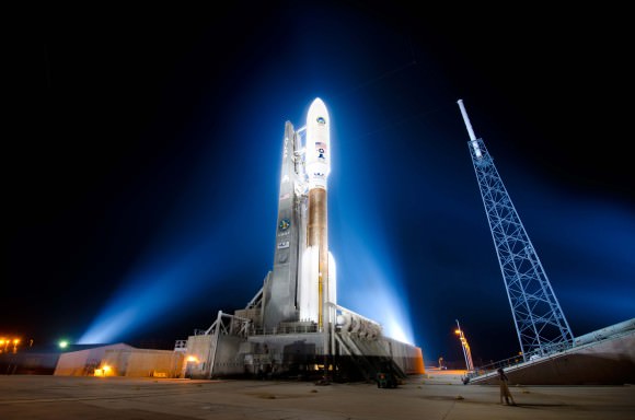
MUOS-3 communications satellite for the US Navy awaits launch atop an Atlas V rocket at pad 41 at Cape Canaveral Air Force Station, FL on Jan. 20, 2015. Credit: John Studwell/AmericaSpace

A busy year of 13 space launches by rocket provider United Launch Alliance (ULA) in 2015 begins with a pair of blastoffs for the US Navy and NASA tonight and next week, emanating from both the US East and West Coasts.

The hefty manifest of 13 liftoffs in 2015 comes hot on the heels of ULA’s banner year in 2014 whereby they completed every one of the firm’s 14 planned launches in 2014 with a 100% success rate.

“What ULA has accomplished in 2014, in support of our customers’ missions, is nothing short of remarkable,” said ULA CEO Tory Bruno.

“When you think about every detail – all of the science, all of the planning, all of the resources – that goes into a single launch, it is hard to believe that we successfully did it at a rate of about once a month, sometimes twice.”

ULA’s stable of launchers includes the Delta II, Delta IV and the Atlas V. They are in direct competition with the Falcon 9 rocket from SpaceX founded by billionaire Elon Musk.

And ULA’s 2015 launch calendar begins tonight with a milestone launch for the US Navy that also marks the 200th launch overall of the venerable Atlas-Centaur rocket that has a renowned history dating back some 52 years to 1962 with multiple variations.

And tonight’s blastoff of the Multi-User Objective System (MUOS-3) satellite for the US Navy involves using the most powerful variant of the rocket, known as the Atlas V 551.

Liftoff of MUOS-3 is set for 7:43 p.m. EDT from Space Launch Complex-41 at Cape Canaveral Air Force Station in Florida. The launch window extends for 44 minutes and the weather outlook is very favorable. It will be carried live on a ULA webcast.

MUOS-3 Navy communications satellite and Atlas V rocket at pad 41 at Cape Canaveral Air Force Station, FL for launch on Jan. 20, 2015. Credit: ULA

The second ULA launch of 2015 comes just over 1 week later on January 29, lofting NASA’s SMAP Earth observation satellite on a Delta II rocket from Vandenberg Air Force Base in California.

MUOS is a next-generation narrowband tactical satellite communications system designed to significantly improve ground communications for U.S. forces on the move, according to ULA.

This is the third satellite in the MUOS series and will provide military users 10 times more communications capability over existing systems, including simultaneous voice, video and data, leveraging 3G mobile communications technology.

ULA’s second launch in 2015 thunders aloft from the US West Coast with NASA’s Soil Moisture Active Passive mission (SMAP). It is the first US Earth-observing satellite designed to collect global observations of surface soil moisture.

SMAP will blastoff from Space Launch Complex 2 at Vandenberg AFB at 9:20 a.m. EST (6:20 a.m. PST) on ULA’s Delta II rocket.

NASA's Soil Moisture Active Passive mission (SMAP) will lift off from Space Launch Complex 2 at Vandenberg Air Force Base in California at 9:20 a.m. EST (6:20 a.m. PST) on a United Launch Alliance Delta II rocket.   Credit:  NASA
NASA’s Soil Moisture Active Passive mission (SMAP) will lift off from Space Launch Complex 2 at Vandenberg Air Force Base in California at 9:20 a.m. EST (6:20 a.m. PST) on a United Launch Alliance Delta II rocket. Credit: NASA

“It goes without saying: ULA had a banner year,” Bruno said. “As we look ahead to 2015, we could not be more honored to continue supporting our nation in one of the most technologically complex, critical American needs: affordable, reliable access to space.”

ULA began operations in December 2006 with the merger of the expendable launch vehicle operations of Boeing and Lockheed Martin.

ULA’s Delta IV Heavy is currently the world’s most powerful rocket and flawlessly launched NASA’s Orion capsule on Dec. 5, 2014 on its highly successful uncrewed maiden test flight on the EFT-1 mission.

Overall, the 14-mission launch manifest in 2014 included 9 national security space missions, 3 space exploration missions, including NASA’s Orion EFT-1 and 2 commercial missions.

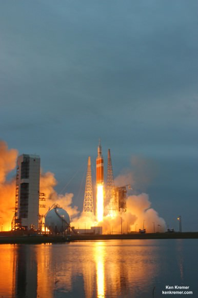
NASA’s first Orion spacecraft blasts off at 7:05 a.m. atop United Launch Alliance Delta 4 Heavy Booster at Space Launch Complex 37 (SLC-37) at Cape Canaveral Air Force Station in Florida on Dec. 5, 2014.   Launch pad remote camera view.   Credit: Ken Kremer - kenkremer.com
NASA’s first Orion spacecraft blasts off at 7:05 a.m. atop United Launch Alliance Delta 4 Heavy Booster at Space Launch Complex 37 (SLC-37) at Cape Canaveral Air Force Station in Florida on Dec. 5, 2014. Launch pad remote camera view. Credit: Ken Kremer – kenkremer.com

Beyond MUOS-3 and SMAP, the launch manifest on tap for 2015 also includes additional NASA science satellites, an ISS commercial cargo resupply mission as well as more GPS satellites for military and civilian uses and top secret national security launches using the Delta II, Delta IV and the Atlas V boosters.

NASA’s Magnetospheric Multiscale Mission (MMS) to study Earth’s magnetic reconnection is scheduled for launch on an Atlas V 421 booster on March 12 from Cape Canaveral. See my up close visit with MMS and NASA Administrator Charles Bolden at NASA Goddard Space Flight Center detailed in my story – here.

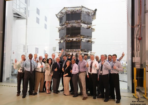
NASA Administrator Charles Bolden poses with the agency’s Magnetospheric Multiscale (MMS) spacecraft, mission personnel, Goddard Center Director Chris Scolese and NASA Associate Administrator John Grunsfeld, during visit to the cleanroom at NASA's Goddard Space Flight Center in Greenbelt, Md., on May 12, 2014.  Credit: Ken Kremer- kenkremer.com
NASA Administrator Charles Bolden poses with the agency’s Magnetospheric Multiscale (MMS) spacecraft, mission personnel, Goddard Center Director Chris Scolese and NASA Associate Administrator John Grunsfeld, during visit to the cleanroom at NASA’s Goddard Space Flight Center in Greenbelt, Md., on May 12, 2014. Credit: Ken Kremer- kenkremer.com

In March, June and September the GPS 2F-9, 2F-10 and 2F-11 navigation satellites will launch on Delta IV and Atlas V rockets from Cape Canaveral.

Two top secret NRO satellites are set to launch on a Delta IV and Atlas in April and August from Vandenberg.

An Air Force Orbital Test Vehicle (OTV) space plane may launch as soon as May atop an Atlas V from Cape Canaveral.

The MUOS-4 liftoff is set for August on another Atlas from the Cape.

The Morelos 3 communications satellite for the Mexican Ministry of Communications and Transportation is due to launch in October from the Cape.

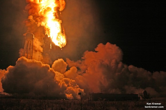
In November, the Atlas V will be pressed into service for the first time to launch the Orbital Sciences Cygnus Orb-4 cargo vehicle to the International Space Station (ISS) as a replacement rocket for the Orbital Sciences Antares rocket which is grounded following its catastrophic Oct. 28 explosion on the Orb-3 mission from NASA Wallops.

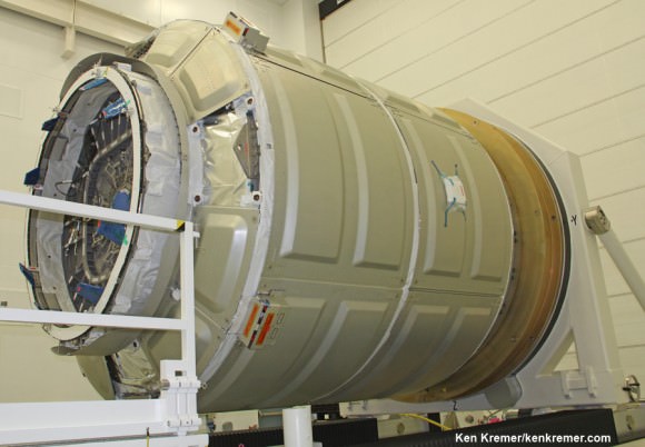
This Cygnus launched atop Antares on Jan. 9 and docked on Jan. 12   Cygnus pressurized cargo module – side view – during exclusive visit by  Ken Kremer/Universe Today to observe prelaunch processing by Orbital Sciences at NASA Wallops, VA. ISS astronauts will open this hatch to unload 2780 pounds of cargo.  Docking mechanism hooks and latches to ISS at left. Credit: Ken Kremer – kenkremer.com
This Cygnus launched atop Antares on Jan. 9, 2014. The next Cygnus Orb-4 will launch for the first time atop an Atlas V in Nov. 2015. Cygnus pressurized cargo module – side view – during exclusive visit by Ken Kremer/Universe Today to observe prelaunch processing by Orbital Sciences at NASA Wallops, VA. ISS astronauts will open this hatch to unload 2780 pounds of cargo. Docking mechanism hooks and latches to ISS at left. Credit: Ken Kremer – kenkremer.com

The Orb-4 launch also marks ULA’s first launch to the ISS. It may be followed by another Cygnus launch atop an Atlas V in 2016 as Orbital works to bring the Antares back into service.

Antares doomed descent to incendiary destruction after first stage propulsion system of Orbital Sciences’ rocket exploded moments after blastoff from NASA’s Wallops Flight Facility, VA, on Oct. 28, 2014. Credit: Ken Kremer – kenkremer.com

In another major milestone down the road, the Atlas V is being man rated since it was chosen to launch the Boeing CST-100 space taxi which NASA selected as one of two new commercial crew vehicles to launch US astronauts to the ISS as soon as 2017.

Stay tuned here for Ken’s continuing Earth and planetary science and human spaceflight news.
Ken Kremer

Having a Rough Winter? Here it is … From Space

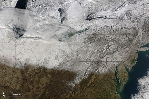
The northeastern US and southeastern Canada, as seen from space on January 13, 2015. Image is from the Moderate Resolution Imaging Spectroradiometer (MODIS) on NASA’s Terra satellite. acquired top image on January 13, 2015.

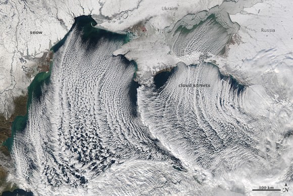
Yes, its been a snowy, icy winter in parts of the US, Canada and Europe and these satellite images look about as miserable as it’s felt for some of us. And no, those aren’t icicles hanging off the coast of Maine and Nova Scotia; those are called ‘cloud streets,’ which are long parallel bands of cumulus clouds that form when cold air blows over warmer waters (like the ocean) and a warmer air layer (temperature inversion) rests over the top of both.

But don’t let the recent cold weather and snow fool you. The Earth as a whole continues to warm, and NASA and NOAA announced today that their analysis puts 2014 as Earth’s warmest year since 1880. 2014 was the 38th straight year with above average global annual temperatures, and December 2014 was the hottest December on record. Additionally, 6 of the 12 months last year set heat records. Even though you might feel cold right now, the last time there was a monthly average global temperatures that set a record for cold was in 1916.

OK, now back to the regularly scheduled feeling sorry for ourselves for the recent cold, snowy weather… see more satellite images below.

Winter storms brought snow and ice to a large portion of the U.S. Midwest and Northeast. NASA’s Aqua satellite acquired this image on January 10, 2015. Credit: NASA.
Snow and 'cloud streets' over the Black Sea on January 8, 2015. Image is from  the Moderate Resolution Imaging Spectroradiometer (MODIS) on the Aqua satellite. Credit: NASA.
Snow and ‘cloud streets’ over the Black Sea on January 8, 2015. Image is from the Moderate Resolution Imaging Spectroradiometer (MODIS) on the Aqua satellite. Credit: NASA.

Here’s a video from NASA about the latest findings on Earth’s changing climate:

Sources: NASA Earth Observatory (US/Canada images), NASA Earth Observatory (Black Sea image), NASA, NOAA Find 2014 Warmest Year in Modern Record

Ammonia Leak Alarm on the ISS Forces Evacuation of US Side, Crew Safe

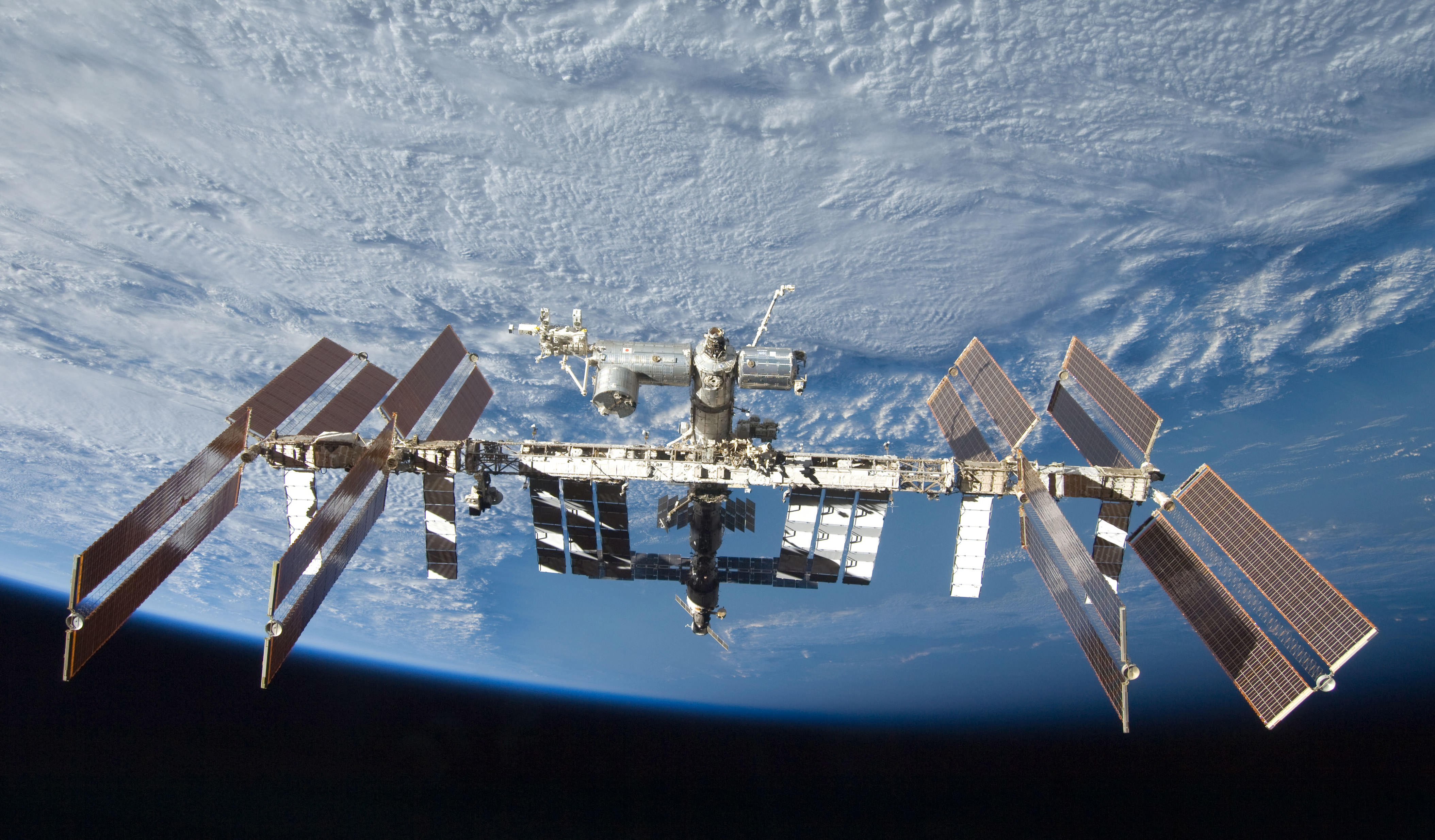
The International Space Station seen by a departing space shuttle in 2009. Credit: NASA

Breaking News: A possible ammonia leak aboard the US side of the International Space Station (ISS) has forced a partial evacuation of the entire crew to the Russian side earlier this morning, Wednesday, Jan. 14.

All six crew members from the US, Italy and Russia are safe and in good shape at this time, says NASA and Roscosmos, the Russian Federal Space Agency.

Hatches between the US and Russian segments were sealed shut, pending further analysis.

Read my late day update – here.

Mission controllers are in the process of assessing whether it’s a real leak or a false alarm due to a faulty sensor or a computer problem. It’s not completely clear at this time.

The latest indications at 11 a.m. EST, Jan. 14, are that it may be a false alarm, says NASA.

“The security of a crew was guaranteed thanks to correct actions of the cosmonauts, astronauts and the crew of the Mission control centres in Moscow and Houston. Further plan of actions in the US modules must be prepared in Houston,” according to Roscosmos.

“For now NASA colleagues are analyzing situation”, – noted the head of Russian Mission Control Centre Maxim Matushin

Ammonia is a toxic substance used as a coolant in the stations complex cooling system that is an essential requirement to continued operation of the station.

There have been prior ammonia leaks aboard the ISS facility.

NASA announced that an alarm sounded in the US segment at about 4 a.m. EST. indicating a possible ammonia leak. As a result, all six Expedition 42 astronauts and cosmonauts evacuated the US segment.

“Flight controllers in Mission Control at NASA’s Johnson Space Center in Houston saw an increase in pressure in the station’s water loop for thermal control system B then later saw a cabin pressure increase that could be indicative of an ammonia leak in the worst case scenario,” according to a NASA announcement.

Therefore as a precaution after the alarm sounded earlier today, the crew was directed to isolate themselves in the Russian segment this morning while teams are evaluating the situation. The crew powered down non-essential equipment in the U.S. segment of the station according to established procedures, said NASA.

“In an exchange at 7:02 a.m. with Expedition 42 Commander Barry Wilmore of NASA, spacecraft communicator James Kelly said flight controllers were analyzing their data but said it is not yet known if the alarm was actually triggered by a leak or whether the situation was caused by a faulty sensor or by a problem in a computer relay box that sends data and commands to various systems on the station.”

The evacuation comes just two days after a commercial SpaceX Dragon cargo freighter successfully rendezvoused and berthed at the station on Monday, Jan. 11.

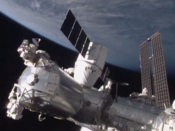
The SpaceX Dragon is attached to the Harmony module. Credit: NASA TV
This view shows the US side of the ISS that was evacuated today, Jan. 14, 2015, by the crew due to possible ammonia leak. The SpaceX CRS-5 Dragon is attached to the Harmony module. Credit: NASA TV

The ISS has been continuously occupied by humans for 15 years.

The current six person crew includes astronauts and cosmonauts from three nations; America, Russia and Italy including four men and two women serving aboard the massive orbiting lab complex.

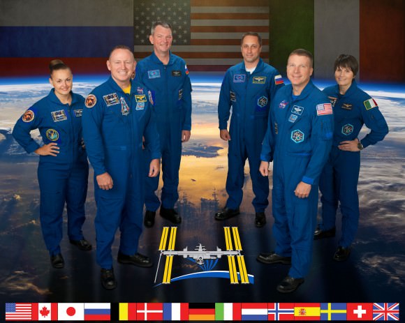
They comprise Expedition 42 Commander Barry “Butch” Wilmore and Terry Virts from NASA, Samantha Cristoforetti from the European Space Agency (ESA) and cosmonauts Aleksandr Samokutyayev, Yelena Serova, and Anton Shkaplerov from Russia.

ISS Expedition 42. Credit: NASA/ESA/Roscosmos

In the case of a life threatening emergency, the crew can rapidly abandon the station aboard the two docked Russian Soyuz capsules. They hold three persons each.

Stay tuned here for Ken’s continuing Earth and planetary science and human spaceflight news.
Ken Kremer