Powerful New Next-Gen US/Japan GPM Satellite to Revolutionize Global Precipitation Observations and Climate Science Research

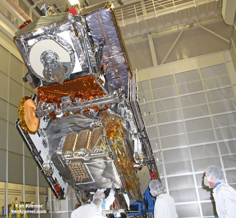
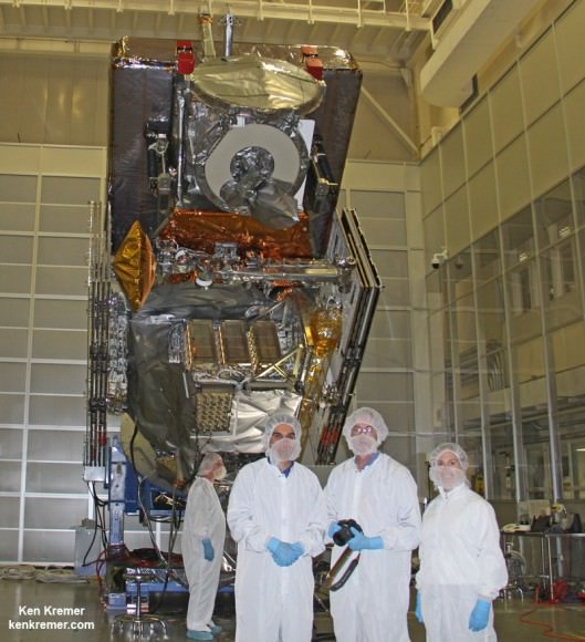
NASA’s next generation Global Precipitation Measurement (GPM) observatory inside the clean room at NASA Goddard Space Flight Center, MD. Technicians at work on final processing during exclusive up-close inspection tour by Universe Today. GPM is slated to launch on February 27, 2014 and will provide global measurements of rain and snow every 3 hours. Credit: Ken Kremer/kenkremer.com

NASA GODDARD SPACE FLIGHT CENTER, MARYLAND – Weather researchers and forecasters worldwide are gushing with excitement in the final days leading to blastoff of the powerful, new Global Precipitation Measurement (GPM) Core Observatory – built by NASA in a joint effort with Japan.

GPM is a next-generation satellite that will provide global, near real time observations of rain and snow from space and thereby open a new revolutionary era in global weather observing and climate science. Therefore it will have a direct impact on society and people’s daily lives worldwide.

The team is counting down to liftoff in less than 5 days, on Feb. 27 at 1:07 PM EST from the Tanegashima Space Center, on Tanegashima Island off southern Japan, atop the highly reliable Mitsubishi Heavy Industries H-IIA rocket.

The GPM launch to low Earth orbit was delayed by both natural and manmade disasters – namely the 2011 Fukushima earthquake in Japan as well as the ridiculous US government shutdown in Oct. 2013. That’s the same foolish shutdown that also delayed NASA’s new MAVEN Mars orbiter and numerous other US space & science projects.
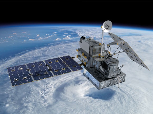
Visualization of the GPM Core Observatory satellite orbiting the planet earth.  Credit: NASA Goddard
Visualization of the GPM Core Observatory satellite orbiting the planet earth. Credit: NASA Goddard

The $933 Million mission is a joint venture between NASA and the Japan Aerospace Exploration Agency (JAXA), Japan’s space agency.

The mission will significantly advance our understanding of Earth’s water and energy cycles and improve forecasting of extreme weather events.

It is equipped with an advanced, higher resolution dual -frequency precipitation (DPR) radar instrument (Ku and Ka band) built by JAXA in Japan and the GPM microwave imager (GMI) built by Ball Aerospace in the US.

“The GPM satellite was built in house at NASA’s Goddard Space Flight Center in Maryland,” Art Azarbarzin, GPM project manager, told Universe Today during my exclusive up-close clean room inspection tour of the huge satellite as final processing was underway.
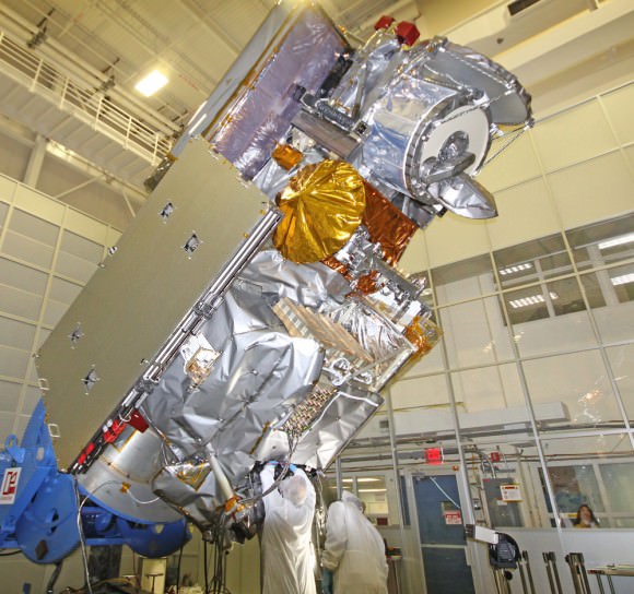
Global Precipitation Management Measurement (GPM) observatory satellite inside the clean room at NASA Goddard Space Flight Center undergoes final processing - side view. Credit: Ken Kremer/kenkremer.com
Global Precipitation Measurement (GPM) observatory satellite inside the clean room at NASA Goddard Space Flight Center undergoes final processing – side view. Credit: Ken Kremer/kenkremer.com

Shortly after my tour of GPM, the 3850 kilogram satellite was carefully packed up for shipment to the Japanese launch site.

“GPM will join a worldwide constellation of current and planned satellites,” Azarbarzin told me during an interview in the Goddard cleanroom with GPM.

gpm-decal-smallAnd the imminent launch to augment the existing satellite constellation can’t come soon enough, he noted.

The GPM observatory will replace the aging NASA/JAXA Tropical Rainfall Measuring Mission (TRMM), satellite launched back in 1997.

“GPM is the direct follow-up to the currently orbiting TRMM satellite,” Azarbarzin explained.

“TRMM is reaching the end of its usable lifetime. GPM launches on February 27, 2014 and we hope it has some overlap with observations from TRMM.”

“The Global Precipitation Measurement (GPM) observatory will provide high resolution global measurements of rain and snow every 3 hours,” Dalia Kirschbaum, GPM research scientist, told me during an interview at Goddard.
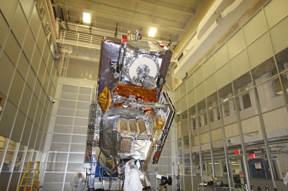
NASA’s next generation Global Precipitation Measurement (GPM) observatory inside the clean room at NASA Goddard Space Flight Center, MD. Technicians at work on final processing during exclusive up-close inspection tour by Universe Today.  GPM is slated to launch on February 27, 2014 and will provide global measurements of rain and snow every 3 hours. Credit: Ken Kremer/kenkremer.com
NASA’s next generation Global Precipitation Measurement (GPM) observatory inside the clean room at NASA Goddard Space Flight Center, MD. Technicians at work on final processing during exclusive up-close inspection tour by Universe Today. GPM is slated to launch on February 27, 2014 and will provide global measurements of rain and snow every 3 hours. Credit: Ken Kremer/kenkremer.com

It is vital to continuing the TRMM measurements and will help provide improved forecasts and advance warning of extreme super storms like Hurricane Sandy and Super Typhoon Haiyan, Azarbarzin and Kirschbaum explained.

Researchers will use the GPM measurements to study climate change, freshwater resources, floods and droughts, and hurricane formation and tracking.

“The water-cycle, so familiar to all school-age young scientists, is one of the most interesting, dynamic, and important elements in our studies of the Earth’s weather and climate,” said John Grunsfeld, associate administrator for NASA’s Science Mission Directorate in Washington, in a statement.

“GPM will provide scientists and forecasters critical information to help us understand and cope with future extreme weather events and fresh water resources.”
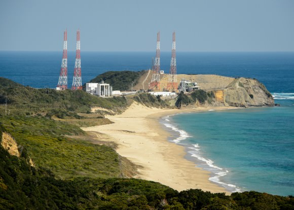
Tanegashima Space Center, on Tanegashima Island off southern Japan
GPM satellite launch site at Tanegashima Space Center, Tanegashima Island, Japan. Credit: NASA

NASA TV will carry the launch live with commentary starting at 12 Noon EST on Feb. 27.

Stay tuned here for Ken’s continuing GPM reports and onsite coverage at NASA Goddard Space Flight Center in Maryland.

And watch for Ken’s continuing planetary and human spaceflight news about Curiosity, Opportunity, Chang’e-3, SpaceX, Orbital Sciences, LADEE, MAVEN, MOM, Mars, Orion and more.
Ken Kremer

NASA/JAXA Global Precipitation Measurement (GPM) satellite inside the clean room at NASA Goddard Space Flight Center, MD, undergoes final processing during exclusive up-close inspection tour by Universe Today:   Dr. Art Azarbarzin/NASA GPM project manager, Dr. Ken Kremer/Universe Today and Dr. Dalia Kirschbaum/NASA GPM research scientist.    Credit: Ken Kremer/kenkremer.com
NASA/JAXA Global Precipitation Measurement (GPM) satellite inside the clean room at NASA Goddard Space Flight Center, MD, undergoes final processing during exclusive up-close inspection tour by Universe Today: Dr. Art Azarbarzin/NASA GPM project manager, Dr. Ken Kremer/Universe Today and Dr. Dalia Kirschbaum/NASA GPM research scientist. Credit: Ken Kremer/kenkremer.com

When Doves Fly: Swarm Of Tiny Satellites Shot From Space Station

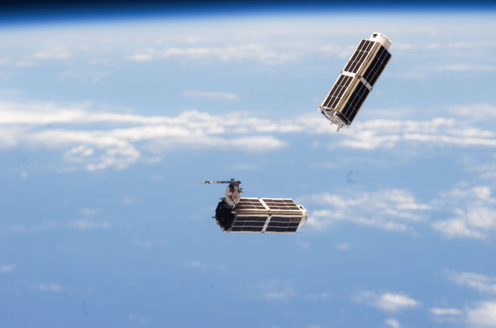
NanoRacks CubeSats deployed from the International Space Station in February 2014, during Expedition 38. Credit: NASA

Astronauts fired up the International Space Station’s Yard-a-Pult (actually, we mean the Japanese Kibo arm’s satellite launcher) this week to send out a flock of Doves or tiny satellites that take pictures of the Earth below. An incredible 28 satellites from Planet Labs of San Francisco are expected to swarm into orbit — the largest fleet yet, NASA says — but there have been delays in launching some of them.

The aim? To provide Earth observation information for any purpose that is needed, whether it’s disaster relief or looking to learn more about the Earth’s environment. Planet Labs and NASA say that commercial applications could include real estate, mapping, construction and oil and gas monitoring.

Deployments of two satellites each began on Tuesday and Wednesday, but NASA noted there are “glitches” (which the agency didn’t specify) that are holding up the launch of other ones. There’s no estimated date yet for sending out the rest of the satellites.

“We believe that the democratization of information about a changing planet is the mission that we are focused on, and that, in and of itself, is going to be quite valuable for the planet,” stated Robbie Schingler, co-founder of Planet Labs.

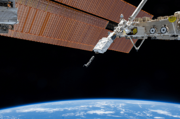
The Japanese Kibo robotic arm on the International Space Station deploys CubeSats during February 2014. The arm was holding a Small Satellite Orbital Deployer to send out the small satellites during Expedition 38. Credit: NASA

Flock 1 is a customer of the NanoRacks CubeSats program. CubeSats are small satellites that heavily rely on computer miniaturization to do the job of Earth observation and telecommunication that previously was the province of much larger and more expensive satellites. NanoRacks provides space both inside and outside the station for research experiments.

Expedition 38’s Rick Mastracchio and Koichi Wakata both commented on the unusual launches. “Two small satellites are deployed from our launcher here on the space station. Each a little bigger than loaf of bread,” Mastracchio tweeted, while Wakata wrote, “Congratulations on the successful deploy of the satellites by the NanoRacks CubeSat Deployer and Kibo robotics!”

For more information on Flock 1, check out the Planet Labs website. You can also check out an animation of how NanoRacks CubeSats deploy in the animation below (which includes a clip from the song “We Are Young” by Fun.)

Space Station to Get a ‘Laser Cannon’

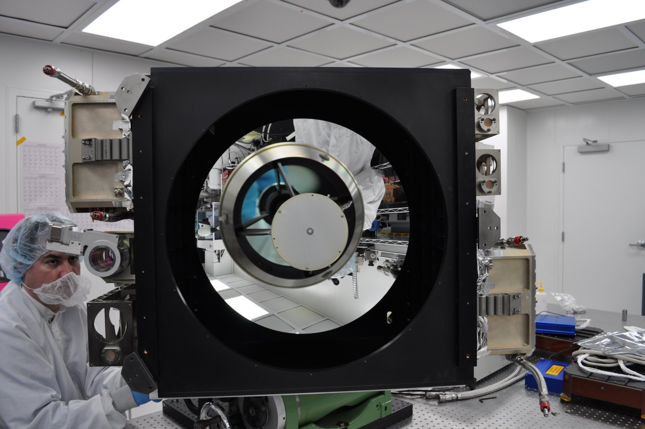
CATS in the laboratory. Credit: NASA/GSFC.

What’s a space station without a laser cannon?

The International Space Station will be getting its very own laser at the end of 2014. And unlike the planet-smashing capabilities of the Death Star of Star Wars fame, this laser will to be enlisted for the purpose of science.

It’s called CATS, and no, it isn’t the latest attempt to put feline astronauts in space. CATS stands for the Cloud Aerosol Transport System. The goal of CATS is to study the distribution of tiny particles of dust and air contaminants known as aerosols.

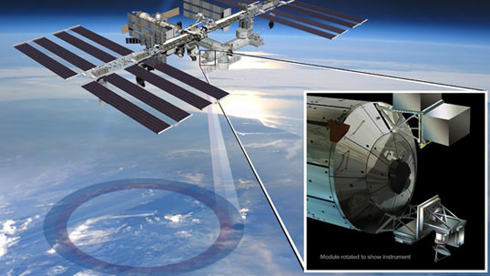
Developed by research scientist Matt McGill at NASA’s Goddard Space Flight Center in Greenbelt Maryland, CATS is slated to head to the International Space Station later this year on September 12th aboard SpaceX’s CRS-5 flight of the Dragon spacecraft. CATS will be installed on the Japanese Experiment Module-Exposed Facility (JEM-EF) and will demonstrate the utility of state-of-the-art multi-wavelength laser technology to study aerosol distribution and transport in the atmosphere.

Such knowledge is critical in understanding the path and circulation of aerosols and pollutants worldwide. When the Eyjafjallajökull volcano erupted in Iceland back in 2010, many trans-Atlantic flights were grounded as a precaution. These measures are necessary as several flights have suffered engine failures in the past due to encounters with volcanic ash clouds, such as the four engine failure of KLM Fight 867 in 1989 and the British Airways Flight 9 incident over Southeast Asia in 1982. Knowing where these dangerous ash clouds are is crucial to the safety of air travel.

The expanding ash cloud spewing from Iceland's Eyjafjallajökull volcano as seen from space in 2010. Credit: NASA.
The expanding ash cloud spewing from Iceland’s Eyjafjallajökull volcano as seen from space in 2010. Credit: NASA.

To accomplish this, CATS will emit 5,000 1 milliJoule laser pulses a second at the 1064, 532 and 355 nanometer wavelengths.  This represents a vast improvement in power requirements and thermal capabilities over a similar instrument currently in service aboard the Cloud-Aerosol Lidar and Infrared Pathfinder Satellite Observations (CALIPSO) Earth remote sensing spacecraft.

And it’s that third 355 nanometer wavelength that will make CATS stand out from CALIPSO. This will also allow researchers to differentiate between particle size and measure the horizontal and vertical distribution of aerosol particles in the atmosphere. CATS will also be capable of measuring the number of individual photons being reflected back at it, which will provide a much better resolution and understanding of current atmospheric activity.

“You get better data quality because you make fewer assumptions, and you get, presumably, a more accurate determination of what kind of particles you’re seeing in the atmosphere,” McGill said in a recent press release.

The International Space Station also provides a unique vantage point for CATS. In a highly inclined 51.7 degree orbit, the station passes over a good swath of the planet on 16 orbits daily on a westward moving ground track that repeats roughly every three days. This will assure CATS has coverage over a large percentage of the planet, including known pollutant transport routes across the northern Pacific and down from Canada over the U.S. Great Lakes region.

While the first two lasers will operate in the infrared and visual wavelengths, said third laser will work in the ultraviolet. And while this will give CATS an enhanced capability, engineers also worry that it may also be susceptible to contamination.  “If you get contamination on any of your outgoing optics, they can self-destruct, and then your system is dead. You end up with a very limited instrument lifetime,” McGill said.

Still, if CATS is successful, it may pave the way for larger, free-flying versions that will monitor long-range atmospheric patterns and shifts in climate due to natural and man-made activity. And the ISS makes a good platform to test pathfinder missions like CATS at low cost. “In our current budget-constrained environment, we need to use what we already have, such as the [station], to do more with less,” McGill said.

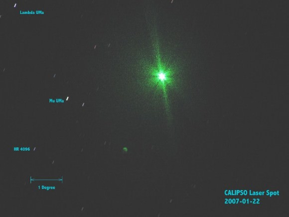
CALIPSO's LiDAR imaged from the ground by Gregg Hendry in 2008. Used with permission.
CALIPSO’s LiDAR imaged from the ground by Gregg Hendry in 2008. Used with permission.

The advent of a LiDAR system aboard the ISS has also generated a spirited discussion in the satellite tracking community concerning prospects for spotting CATS in operation from the ground. The CALIPSO LiDAR has been captured by ground spotters in the past. However, CALIPSO fires a much more powerful 110 milliJoule pulse at a rate of 20 times a second. Still, the lower power CATS system will be firing at a much faster rate, delivering a cumulative 5,000 milliJoules a second.  CATS won’t be bright enough to show up on an illuminated pass of the ISS, but it just might be visible during darkened passes of the ISS through the Earth’s shadow. And, unlike CALLIPSO — which is part of the difficult to observe A-Train of Earth-observing satellites — the ISS passes in view of a majority of humanity. At very least, activity from CATS will be worth watching out for, and may well be seen either visually or photographically.

We’ll soon be adding CATS to the long list of outstanding science experiments being conducted aboard the International Space Station, and the sight of this “fully armed and operational battle station” may soon be coming to a dark sky site near you!

UPDATE: Six-Hour Spacewalk Yields Success for UrtheCast Cameras

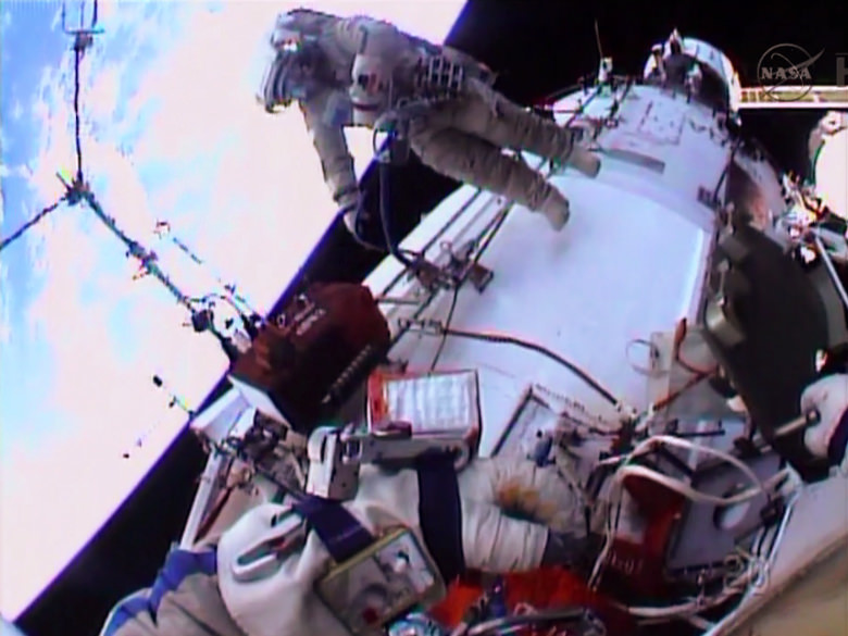
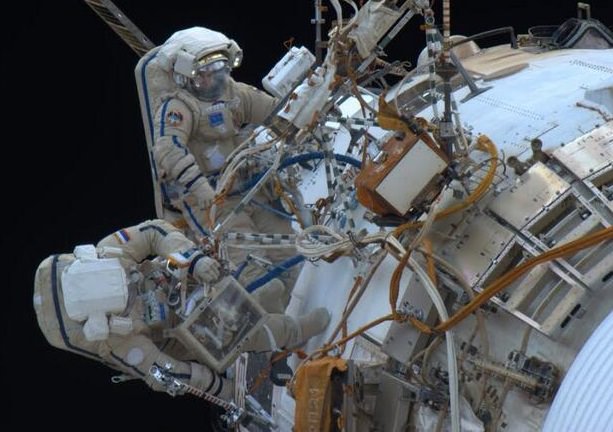
Expedition 38 cosmonaut Oleg Kotov during a January 2014 spacewalk, outside the Zvezda service module. Credit: NASA TV

UPDATE: As of Tuesday morning (Eastern time), UrtheCast announced that telemetry was successfully received, “contrary to the online broadcast of the installation.” CEO Scott Larson added that his company “can now focus on the routine commissioning of the cameras in preparation for the unveiling of our Ultra HD, color video of Earth.” Below is the report from Monday.

A second crack at installing the UrtheCast cameras on the International Space Station also ran into data trouble, according to a press release from NASA, although the company involved with the cameras says it is still waiting for more information about the telemetry.

Expedition 38 spacewalkers Oleg Kotov and Sergey Ryazanskiy were again trying to put the cameras outside the station for UrtheCast to provide live views of Earth to subscribers. The cosmonauts’ first attempt on Dec. 27 showed telemetry problems, at which point the spacewalkers were instructed to bring the cameras back inside.

“The duo translated to the Zvezda service module and installed a high-resolution camera and a medium-resolution camera to capture Earth imagery. However, the medium resolution camera again experienced telemetry issues,” NASA stated.

On Twitter, however, UrtheCast stated that it is still awaiting confirmation on the status of the telemetry. We’ll keep you posted when they issue an update.

Kotov and Ryazanskiy spent six hours, eight minutes outside performing this and other routine tasks, marking the fourth spacewalk in about a month for Expedition 38. Besides the other Russian spacewalk in late December, two American astronauts ventured out close to Christmas to make a contingency swap on a faulty ammonia pump.

Dusty, Windy And Damp: Five NASA Probes To Hunt Down Climate Change in 2014

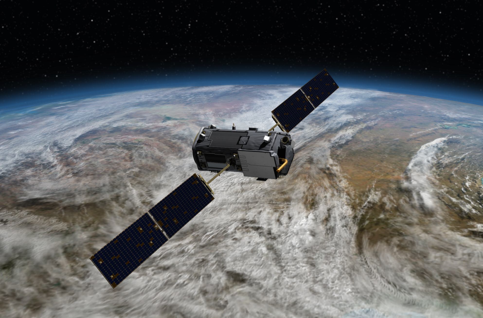
Artist's conception of NASA's Orbiting Carbon Observatory, which will examine carbon dioxide in the atmosphere (and its effect on climate change) after an expected launch in July 2014. Credit: NASA

How badly will climate change affect our planet? Different models tell us different things, and that’s partly because we need more precise information about the factors that warm the world. How much is sea level rising? What are the levels of carbon dioxide in the atmosphere? All of these things must be known.

NASA expects to launch five Earth science missions this year, which is the biggest roster in more than a decade. They’ll track rainfall, seek water hiding in soil, and examine carbon dioxide and ocean winds around the world. Here’s a quick rundown of the busy launch schedule:

Global Precipitation Measurement (GPM) Core Observatory (Feb. 27): This will be the first of a series of satellites to look at snow and rain from space. “This new information will help answer questions about our planet’s life-sustaining water cycle, and improve water resource management and weather forecasting,” NASA stated. This joint spacecraft with the Japanese Aerospace Exploration Agency (JAXA) will launch from Japan’s Tanegashima Space Center on a H-IIA rocket. GPM was built at NASA’s Goddard Space Flight Center in Maryland.

ISS-RapidScat (June 6): This sensor will sit on the International Space Station and monitor ocean winds (including storms and hurricanes). What’s interesting about this mission is its use of old parts, NASA points out, as well as the decision to mount it on a station rather than take the more expensive route of making it a separate satellite. The probe will launch on a SpaceX Dragon spacecraft (aboard a SpaceX Falcon 9 rocket) from Florida’s Cape Canaveral Air Force Station as part of a regular commercial resupply flight.

Artist's conception of how ISS-RapidScat will work. Credit: NASA/JPL-Caltech/Johnson Space Center
Artist’s conception of how ISS-RapidScat will work. Credit: NASA/JPL-Caltech/Johnson Space Center

Orbiting Carbon Observatory (OCO)-2 (July): NASA plans to take a second crack at this type of satellite after the OCO launch failure in 2009. The satellite will seek out carbon dioxide to better understand where it is emitted (in both natural and artificial processes) and how it moves through the water, air and land. This will launch from California’s Vandenberg Air Force Base on a Delta II rocket. OCO-2 will be managed by NASA’s Jet Propulsion Laboratory in California.

Cloud-Aerosol Transport System (CATS) (Sept. 12): This technology demonstration project will use lasers, in three wavelengths, to examine tiny particles borne into the atmosphere from phenomena such as pollution, smoke, dust and volcanoes. “These aerosol particles pose human health risks at ground level and influence global climate through their impact on cloud cover and solar radiation in Earth’s atmosphere,” NASA stated. This will also leave Earth aboard a SpaceX resupply flight from Cape Canaveral.

Soil Moisture Active Passive (SMAP) mission (November): Will check out the moisture level of soil, with the aim of refining “predictions of agricultural productivity, weather and climate,” NASA stated. Also managed by JPL, this satellite will spend its time in an almost-polar “sun-synchronous” orbit that keeps the sun’s illumination below constant during SMAP’s turns around the Earth. SMAP will launch from Vandenberg on a Delta II rocket.

Source: NASA

Latest Data Shows Global Climate Continues Warming Trend

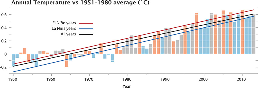
Chart of the temperature anomalies for 1950-2013, also showing the phase of the El Niñ0-La Niña cycle. (Image Credit: NASA/GSFC/Earth Observatory, NASA/GISS)

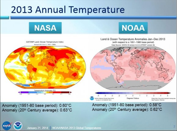
The latest statistics are in from 2013 and both NASA’s and NOAA’s measurements of global temperatures show Earth continued to experience temperatures warmer than those measured several decades ago.

NASA scientists say 2013 tied with 2009 and 2006 for the seventh warmest year since 1880, continuing a long-term trend of rising global temperatures, while NOAA – which uses a different method of analyzing temperature data – said that 2013 tied with 2003 as 4th-warmest year globally since 1880.

“The long-term trends are very clear, and they’re not going to disappear,” said climatologist Gavin Schmidt from NASA’s Goddard Institute for Space Studies (GISS). “It isn’t an error in our calculations.”

Land and ocean global temperatures in 2013 from both NASA and NOAA. Via NASA.

NASA data shows that since 1950, average temperatures have increased 1.1°F to an average of 58.3° in 2013.

NOAA data shows the average temperature across global land and ocean surfaces was 1.12 degrees above the 20th-century average. This is the 37th consecutive year that the annual temperature was above the long-term average.

This coincides with another recent study that showed the so-called “pause” in global warming is not happening, and that the temperatures over the past 15 years are still on the rise.

Both NASA and NOAA scientists say the increase in greenhouse gas levels continue to drive the temperature increase.

Additionally, with the exception of 1998, the 10 warmest years in the 134-year record all have occurred since 2000, with 2010 and 2005 ranking as the warmest years on record.

NASA says the average temperature in 2013 was 58.3 degrees Fahrenheit (14.6 Celsius), which is 1.1 F (0.6 C) warmer than the mid-20th century baseline. The average global temperature has risen about 1.4 degrees F (0.8 C) since 1880, according to the new analysis. Exact rankings for individual years are sensitive to data inputs and analysis methods.

“Long-term trends in surface temperatures are unusual and 2013 adds to the evidence for ongoing climate change,” GISS climatologist Gavin Schmidt said. “While one year or one season can be affected by random weather events, this analysis shows the necessity for continued, long-term monitoring.”

Scientists emphasize that weather patterns always will cause fluctuations in average temperatures from year to year, but the continued increases in greenhouse gas levels in Earth’s atmosphere are driving a long-term rise in global temperatures. Each successive year will not necessarily be warmer than the year before, but with the current level of greenhouse gas emissions, scientists expect each successive decade to be warmer than the previous.

More from NASA:

Carbon dioxide is a greenhouse gas that traps heat and plays a major role in controlling changes to Earth’s climate. It occurs naturally and also is emitted by the burning of fossil fuels for energy. Driven by increasing man-made emissions, the level of carbon dioxide in Earth’s atmosphere presently is higher than at any time in the last 800,000 years.

The carbon dioxide level in the atmosphere was about 285 parts per million in 1880, the first year in the GISS temperature record. By 1960, the atmospheric carbon dioxide concentration, measured at the National Oceanic and Atmospheric Administration’s (NOAA) Mauna Loa Observatory in Hawaii, was about 315 parts per million. This measurement peaked last year at more than 400 parts per million.

While the world experienced relatively warm temperatures in 2013, the continental United States experienced the 42nd warmest year on record, according to GISS analysis. For some other countries, such as Australia, 2013 was the hottest year on record.

The temperature analysis produced at GISS is compiled from weather data from more than 1,000 meteorological stations around the world, satellite observations of sea-surface temperature, and Antarctic research station measurements, taking into account station history and urban heat island effects. Software is used to calculate the difference between surface temperature in a given month and the average temperature for the same place from 1951 to 1980. This three-decade period functions as a baseline for the analysis. It has been 38 years since the recording of a year of cooler than average temperatures.

The GISS temperature record is one of several global temperature analyses, along with those produced by the Met Office Hadley Centre in the United Kingdom and NOAA’s National Climatic Data Center in Asheville, N.C. These three primary records use slightly different methods, but overall, their trends show close agreement.

You can read NASA’s press release here, and NOAA’s here. Here is a link to a presentation of the data released today from Gavin Schmidt of NASA and Tom Karl, director of NOAA’s Climatic Data Center.

Editor’s note: First quote from Gavin Schmidt is from Jacob Ward on Twitter.

China’s Yutu Moon Rover and Chang’e-3 Lander – Gallery of New Images & 1st Earth Portrait

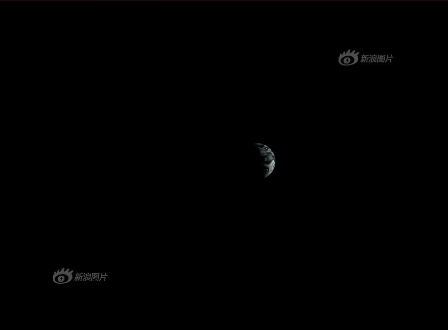
The Earth from the Moon – by Chang’e-3 on Christmas Day Lander camera snapped this image on Christmas Day 2013. Credit: Chinese Academy of Sciences

The Earth from the Moon – by Chang’e-3 on Christmas Day
Lander camera snapped this image on Christmas Day 2013. Credit: Chinese Academy of Sciences[/caption]

Nearly a month after the stunningly successful soft landing on the Moon by China’s first lunar mission on Dec. 14, 2013, the Chinese Academy of Sciences has at last released far higher quality digital imagery snapped by the Chang’e-3 lander and Yutu moon rover.

This release of improved images is long overdue.

And perhaps the best news of all involves a belated Christmas present to humanity – the publication of never before seen and absolutely stunning images of the Earth from the Moon captured by the lander on Christmas Day 2013.

We haven’t seen the Earth from the Moon’s surface in 4 decades – not since the 1970’s.

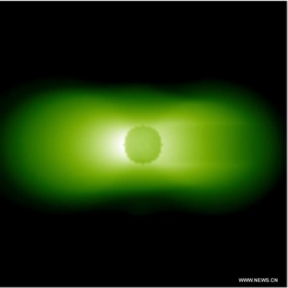
Photo taken by the extreme ultraviolet camera on Dec. 16, 2013 shows the observation of the Earth's plasmasphere by the Chang’e-3 lander. Credit: Chinese Academy of Sciences
Photo taken by the extreme ultraviolet camera on Dec. 16, 2013 shows the observation of the Earth’s plasmasphere by the Chang’e-3 lander. Credit: Chinese Academy of Sciences

Until now, most of the Chang’e-3 mission images we’ve seen have essentially been rather low resolution pictures of pictures – that is screenshots or photos taken of the imagery that has been flashed onto large projection screens at the Beijing Aerospace Control Center, and then distributed by Chinese government media outlets.

So they have been degraded several times over.

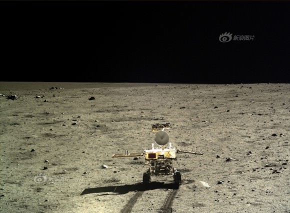
Portrait photo of Yutu moon rover taken by camera on the Chang'e-3 moon lander on Dec. 15, 2013 shortly after rolling all 6 wheels onto lunar surface.  Credit: Chinese Academy of Sciences
Portrait photo of Yutu moon rover taken by camera on the Chang’e-3 moon lander on Dec. 15, 2013 shortly after rolling all 6 wheels onto lunar surface. Credit: Chinese Academy of Sciences

I’ve collected a gallery of the new Chang’e-3 lunar photos here for all to enjoy – see above and below.

The gallery includes photos taken during the final moments of the descent and landing on Dec. 14, 2013, as well as portraits and 360 degree moonscape panoramas taken by both spacecraft after Yutu rolled its wheels onto the loose lunar soil 7 hours later on Dec. 15, and the fabulous new images of Earth in visible and UV light.

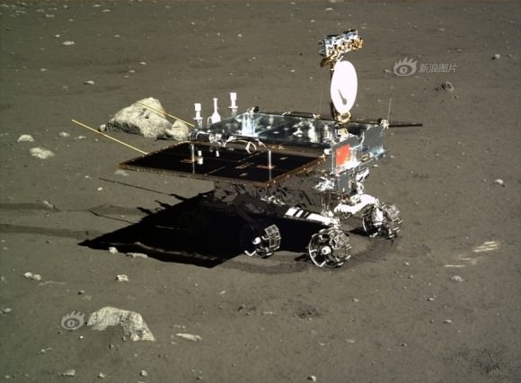
Yutu moon rover imaged by camera on the Chang'e-3 moon lander on Dec. 16, 2013. Credit: Chinese Academy of Sciences
Yutu moon rover imaged by camera on the Chang’e-3 moon lander on Dec. 16, 2013. Credit: Chinese Academy of Sciences

Yutu and the lander are about to awaken from their self induced slumber which began at Christmas time to coincide with the dawn of the the utterly frigid two week long lunar night.

Temperatures plunged to below minus 180 degrees Celsius.

They went to sleep to conserve energy since there is no sunlight to generate power with the solar arrays.

Yutu portrait taken by the Chang’e-3 lander on Dec. 22, 2013.  China’s 1st Moon rover ‘Yutu’ embarks on thrilling adventure marking humanity’s first lunar surface visit in nearly four decades.  Credit: Chinese Academy of Sciences
Yutu portrait taken by the Chang’e-3 lander on Dec. 22, 2013. China’s 1st Moon rover ‘Yutu’ embarks on thrilling adventure marking humanity’s first lunar surface visit in nearly four decades. Credit: Chinese Academy of Sciences

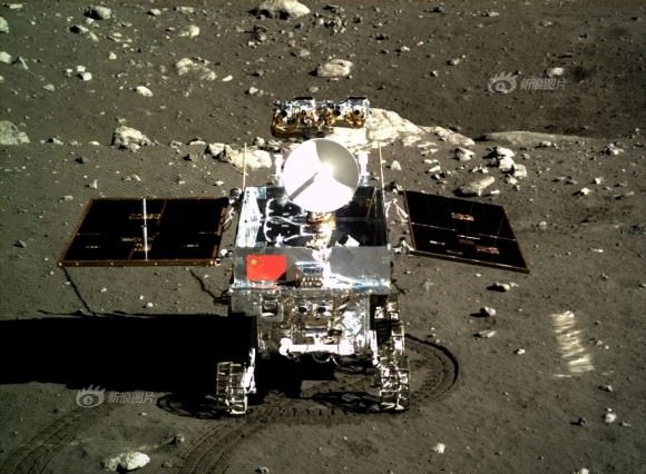
After driving off the lander, Yutu – which means ‘Jade Rabbit’ – drove in a semicircle around the lander and headed south.

Jade Rabbit stopped at 5 designated places.

The pair of Chinese spacecraft then snapped images of one another at each location. Some of those images were included in this new batch.

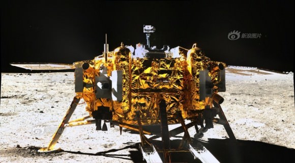
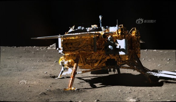
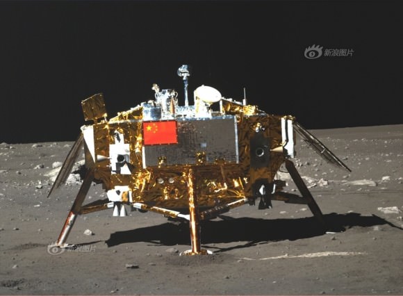
So you can see the lander from 3 different perspectives collected here:

1st Photo of Chang'e-3 moon lander taken by the panoramic camera on the Yutu moon rover after it drove all 6 wheels onto the lunar surface on Dec. 15, 2013. Credit: CNSA
1st Photo of Chang’e-3 moon lander taken by the panoramic camera on the Yutu moon rover after it drove all 6 wheels onto the lunar surface on Dec. 15, 2013. Credit: Chinese Academy of Sciences
Side view Chang'e-3 moon lander in this image taken by the panoramic camera on the Yutu moon rover as it drove in a semicircle around the lander heading south. Credit: Chinese Academy of Sciences
Side view Chang’e-3 moon lander in this image taken by the panoramic camera on the Yutu moon rover as it drove in a semicircle around the lander heading south. Credit: Chinese Academy of Sciences
Photo of Chang'e-3 moon lander emblazoned with Chinese national flag taken by the panoramic camera on the Yutu moon rover on Dec. 22, 2013. Credit: CNSA
Photo of Chang’e-3 moon lander emblazoned with Chinese national flag taken by the panoramic camera on the Yutu moon rover on Dec. 22, 2013 during 5th and final stop as it drove in a semicircle around the lander heading south. Yutu is looking north, lander looking south. Credit: Chinese Academy of Sciences

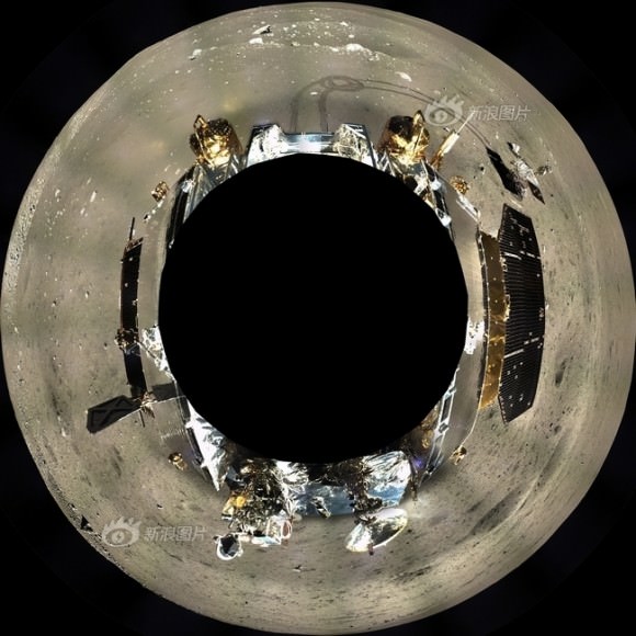
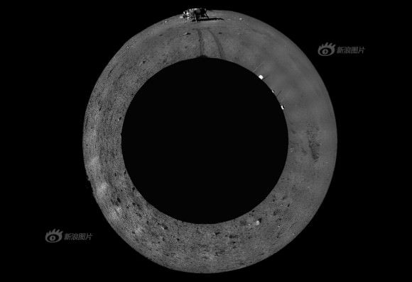
Here’s a pair of very cool 360 degree panoramas – taken by each spacecraft and showing the other.

This digitally-combined polar panorama shows a 360 degree color view of the moonscape around the Chang’e-3 lander after the Yutu moon rover drove onto the lunar surface leaving visible tracks behind.  Images were taken from Dec. 17 to Dec. 18, 2013.  Credit: Chinese Academy of Sciences
This digitally-combined polar panorama shows a 360 degree color view of the moonscape around the Chang’e-3 lander after the Yutu moon rover drove onto the lunar surface leaving visible tracks behind. Images were taken from Dec. 17 to Dec. 18, 2013. Credit: Chinese Academy of Sciences
This digitally-combined polar panorama shows a 360 degree black and white view of the moonscape around the Yutu moon rover after it drove off the Chang’e-3 lander at top and left visible tracks behind.  Images were taken on Dec. 23, 2013.  Credit: Chinese Academy of Sciences
This digitally-combined polar panorama shows a 360 degree black and white view of the moonscape around the Yutu moon rover after it drove off the Chang’e-3 lander at top and left visible tracks behind. Images were taken on Dec. 23, 2013. Credit: Chinese Academy of Sciences
1st panorama around Chang’e-3 landing site after China’s Yutu rover drove onto the Moon’s surface on Dec. 15, 2013. The images were taken by Chang’e-3 lander following Dec. 14 touchdown. Panoramic view was created from screen shots of a news video assembled into a mosaic. Credit: CNSA/CCTV/screenshot mosaics & processing by Marco Di Lorenzo/Ken Kremer

Finally here’s imagery taken during the landing sequence by the descent imager in the final minutes before touchdown at Mare Imbrium, nearby the Bay of Rainbows, or Sinus Iridum region.

It is located in the upper left portion of the moon as seen from Earth. You can easily see the landing site with your own eyes.

And be sure to check my earlier story with an eye popping astronauts eye view video combining all the descent imagery – here.

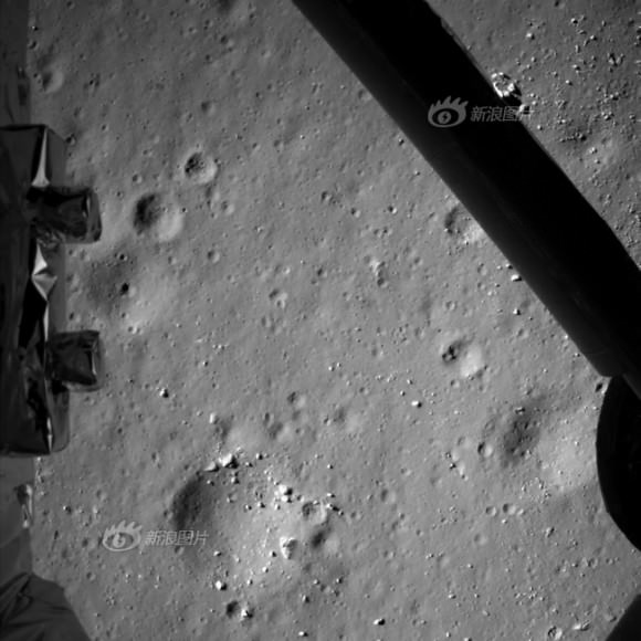
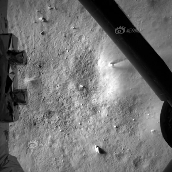
Photo taken by the descent imaging camera on Dec. 14, 2013 shows lunar landscape during Chang'e-3 lunar probe's landing at an altitude of 99 meters.  Credit: Chinese Academy of Sciences
Photo taken by the descent imaging camera on Dec. 14, 2013 shows lunar landscape during Chang’e-3 lunar probe’s landing at an altitude of 99 meters. Credit: Chinese Academy of Sciences
Photo taken by the descent imaging camera on Dec. 14, 2013 shows lunar landscape during Chang'e-3 lunar probe's landing at an altitude of 7.9 kilometers.  Credit: Chinese Academy of Sciences
Photo taken by the descent imaging camera on Dec. 14, 2013 shows lunar landscape during Chang’e-3 lunar probe’s landing at an altitude of 7.9 meters. Credit: Chinese Academy of Sciences

The landmark Chang’e-3 mission marks the first time that China has sent a spacecraft to touchdown on the surface of an extraterrestrial body.

China is only the 3rd country in the world to successfully soft land a spacecraft on Earth’s nearest neighbor after the United States and the Soviet Union.

Stay tuned here for Ken’s continuing Chang’e-3, Orbital Sciences, SpaceX, commercial space, LADEE, Mars and more news.

Ken Kremer

Satellite Image of the “Polar Vortex” Over the US

This image was captured by NOAA's GOES-East satellite on January 6, 2014 at 1601 UTC/11:01 a.m. EST. A frontal system that brought rain to the coast is draped from north to south along the U.S. East Coast. Behind the front lies the clearer skies bitter cold air associated with the Polar Vortex.

If you live in the north and eastern part of the US, you’re probably experiencing some frigid weather. You’re probably also hearing people talk about something called a “polar vortex.”

Just what is a polar vortex and why is it making the temperatures so cold?

This image was captured by NOAA’s GOES-East satellite on Jan. 6, 2014, at 11:01 a.m. EST (1601 UTC). A frontal system that brought rain and snow to the US East coast is seen draped from north to south, and behind the front lies the clearer skies bitter cold air associated with the polar vortex. Also visible in the image is snow on the ground in Minnesota, Wisconsin, Illinois, Indiana, Ohio, Michigan, Iowa and Missouri. The clouds over Texas are associated with a low pressure system centered over western Oklahoma that is part of the cold front connected to the movement of the polar vortex.

NASA explains that the polar vortex is a “whirling and persistent large area of low pressure, found typically over both North and South poles.”

Weather reports say the northern polar vortex was pushing southward over western Wisconsin and eastern Minnesota on Monday, Jan. 6, 2014, and was bringing frigid temperatures to half of the continental United States. It is expected to move northward back over Canada toward the end of the week.

More about the polar vortex:

Both the northern and southern polar vortexes are located in the middle and upper troposphere (lowest level of the atmosphere) and the stratosphere (next level up in the atmosphere). The polar vortex is a winter phenomenon. It develops and strengthens in its respective hemispheres’ winters as the sun sets over the polar region and temperatures cool. They weaken in the summer. In the Northern Hemisphere, they circulate in a counterclockwise direction, so the vortex sitting over western Wisconsin is sweeping in cold Arctic air around it.

Source: NASA

Spacewalkers Battle Camera Glitch, Pull Back For Another Day

Russian cosmonauts Fyodor Yurchikhin and Alexander Misurkin attempted to install UrtheCast cameras on the space station on Dec. 27, 2013, but the cameras did not send telemetry as expected. At the time, the cause of the problem was not known. The Expedition 38 astronauts were instructed to bring the cameras back inside for more analysis. Credit: Rick Mastracchio (Twitter)

Customers eager to watch live, high-definition images of Earth may have to wait a bit longer. Two Russian spacewalkers were unable to get two UrtheCast cameras to function despite spending eight hours and seven minutes outside yesterday (Dec. 27) — the longest spacewalk in Russian history.

The cause of the problem is not known. Oleg Kotov and Sergey Ryazanskiy followed all the steps as instructed, but controllers did not see telemetry or data flowing from the cameras as expected. The spacewalkers tried unplugging and replugging cables and other steps to fix the problem, but were eventually told to take some pictures of the equipment and then bring the cameras back inside for more analysis.

“So it appears we have seen an unsuccessful attempt at bringing those two cameras to life,”said Rob Navias, NASA’s Mission Control commentator, in live remarks published on CBS.

“The exact cause of the problem is not known at this point. The Russian flight control team will spend some time, obviously, analyzing the data and trying to understand from the analysis of these photographs whether or not the problem lies in the electrical connectors themselves or in the cameras, which of course would be a more significant issue.”

In remarks on Twitter, UrtheCast said it was preparing an official statement to release. ” ‘Tis the nature of space tech,” the British Columbia-based company said in response to a comment talking about the challenges of doing high-tech work in space. The company also made a comment to Reuters saying there was a problem with camera connectivity.

NASA astronaut Mike Hopkins during a spacewalk Dec. 24, 2013 to replace a malfunctioning ammonia pump on the International Space Station. He and fellow Expedition 38 astronaut Rick Mastracchio took two spacewalks to perform the repair job. Credit: NASA

UrtheCast plans to use the two cameras to broadcast live views of the Earth to paying customers (particularly government and private agencies), while also serving as an educational platform for young students. The company is working directly with Russian aerospace giant RSC Energia and has no agreement with NASA for the work, according to this past Universe Today report.

The longest spacewalk in history took place on March 11, 2001 and took eight hours, 56 minutes. NASA astronauts Jim Voss and Susan Helms were doing work on the International Space Station during the record-setting jaunt.

This was the third spacewalk in a week on station. The other two were performed by Rick Mastracchio and Mike Hopkins, who replaced an ammonia pump needed to keep one of the station’s two cooling loops functioning. Experiments are gradually coming back online, NASA said, after the equipment spent two weeks in a forced shutdown.

See the Apollo 8 “Earthrise” in a Whole New Way

Earthrise - Apollo 8
Earthrise - as seen from Apollo 8. Credit: NASA.

One of the most famous images from the history of spaceflight is the picture taken by the crew of Apollo 8 of the “Earthrise” — the first color picture of taken of Earth as it became visible as the spacecraft came from behind the farside of the Moon. The photo was taken 45 years ago on December 24, 1968. It’s been called one of the most influential environmental photographs ever taken, and is one of the most-published pictures ever. As the photographer of this photo, astronaut Bill Anders has said, “We came all this way to discover the Moon. And what we really did discover is Earth.”

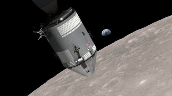
The NASA Goddard Scientific Visualization Studio has now released a new video that is a re-creation of that first Earthrise. The video is based on detailed analysis of Apollo 8 photography, including vertical stereo photos that were being taken at the same time as the Earthrise photos, combined with recent topographic models from the Lunar Reconnaissance Orbiter.

“In the video,” space historian Andrew Chaikin — who narrates the new video — told Universe Today, “we see the Moon’s surface, generated from LRO data, exactly as it appeared to the astronauts through the different windows of the spacecraft. We also hear the astronauts’ voices as captured by the spacecraft’s onboard voice recorder, synchronized with the visual. The video reveals new details about this historic event and the resulting color photograph, which became an icon of the 20th century.”

Enjoy this wonderful new video, which explains how this historic image was taken. The visualization shows how Apollo 8 Commander Frank Borman and crew members Anders and James Lovell worked together to photograph the stunning scene as their spacecraft orbited the Moon in 1968. The video allows anyone to virtually ride with the astronauts and experience the awe they felt at the vista in front of them.

The “Earthrise” photo is the cover photo of TIME’s Great Images of the 20th Century, and is the central photo on the cover of LIFE’s 100 Photographs That Changed the World.

“Earthrise had a profound impact on our attitudes toward our home planet, quickly becoming an icon of the environmental movement,” said Ernie Wright, who lead the video project with the SVS.

You can read more details of how the video was put together in this NASA press release.

A computer-generated visualization of the Apollo 8 spacecraft in orbit around the moon, with Earth rising over the horizon. Image Credit:  Ernie Wright/NASA Goddard Scientific Visualization Studio
A computer-generated visualization of the Apollo 8 spacecraft in orbit around the moon, with Earth rising over the horizon.
Image Credit:
Ernie Wright/NASA Goddard Scientific Visualization Studio