Super-Typhoon Haiyan Causes Catastrophic Death & Destruction – Space Images from NASA, ISRO, Roscosmos & ISS

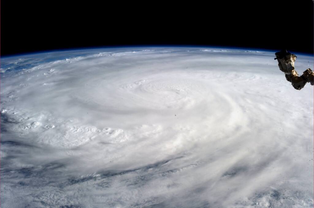
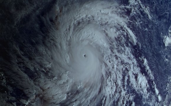
Super Typhoon Haiyan over the Philippines on November 9, 2013 as imaged from Earth orbit by NASA Astronaut Karen Nyberg aboard the International Space Station. Credit: NASA/Karen Nyberg

Super Typhoon Haiyan over the Philippines on November 9, 2013 as imaged from Earth orbit by NASA Astronaut Karen Nyberg aboard the International Space Station.Category 5 killer storm Haiyan stretches across the entire photo from about 250 miles (400 kilometer) altitude. Credit: NASA/Karen Nyberg
See more Super Typhoon Haiyan imagery and video below
[/caption]

NASA GODDARD SPACE FLIGHT CENTER, MARYLAND – Super Typhoon Haiyan smashed into the island nation of the Philippines, Friday, Nov. 8, with maximum sustained winds estimated at exceeding 195 MPH (315 kilometer per hour) by the U.S. Navy Joint Typhoon Warning Center – leaving an enormous region of catastrophic death and destruction in its terrible wake.

The Red Cross estimates over 1200 deaths so far. The final toll could be significantly higher. Local media reports today say bodies of men, women and children are now washing on shore.

The enormous scale of Super Typhoon Haiyan can be vividly seen in space imagery captured by NASA, ISRO and Russian satellites – as well as astronaut Karen Nyberg flying overhead on board the International Space Station (ISS); collected here.

As Super-Typhoon Haiyan moved over the central Philippines on Nov. 8 at 05:10 UTC/12:10 a.m. EDT, the MODIS instrument aboard NASA's Aqua satellite captured this visible image.   Credit: NASA Goddard MODIS Rapid Response Team
As Super-Typhoon Haiyan moved over the central Philippines on Nov. 8 at 05:10 UTC/12:10 a.m. EDT, the MODIS instrument aboard NASA’s Aqua satellite captured this visible image. Credit: NASA Goddard MODIS Rapid Response Team

Super Typhoon Haiyan is reported to be the largest and most powerful storm ever to make landfall in recorded human history.

Haiyan is classified as a Category 5 monster storm on the U.S. Saffir-Simpson scale.

It struck the central Philippines municipality of Guiuan at the southern tip of the province of Eastern Samar early Friday morning Nov. 8 at 20:45 UTC (4:45 am local time).

As Haiyan hit the central Philippines, NASA says wind gusts exceeded 235 mph (379 kilometers per hour).

The high resolution imagery and precise measurements provided by the worlds constellation of Earth observing space satellites (including NASA, Roscosmos, ISRO, ESA, JAXA) are absolutely essential to tracking killer storms and providing significant advance warning to evacuate residents in affected areas to help minimize the death toll and damage.

More than 800,000 people were evacuated. The storm surge caused waves exceeding 30 feet (10 meters), mudslides and flash flooding.

NASA’s Tropical Rainfall Measuring Mission (TRMM) satellite captured visible, microwave and infrared data on the storm just as it was crossing the island of Leyte in the central Philippines, reports NASA – see image below.

NASA's TRMM satellite data on Nov. 8 at 00:19 UTC showed Haiyan had a well-defined eye surrounded by a symmetric area of moderate rain (green ring with a blue center) with several rainbands wrapping in from the south (green arcs) while crossing the island of Leyte in the central Philippines.  Credit:  NASA/SSAI, Hal Pierce
NASA’s TRMM satellite data on Nov. 8 at 00:19 UTC showed Haiyan had a well-defined eye surrounded by a symmetric area of moderate rain (green ring with a blue center) with several rainbands wrapping in from the south (green arcs) while crossing the island of Leyte in the central Philippines. Credit: NASA/SSAI, Hal Pierce

TRMM data from rain rates are measured by the TRMM Precipitation Radar (PR) and TRMM Microwave Imager (TMI) and combined with infrared (IR) data from the TRMM Visible Infrared Scanner (VIRS) by science teams working at NASA’s Goddard Space Flight Center in Greenbelt, Md.

Coincidentally NASA Goddard has just completed assembly of the next generation weather satellite Global Precipitation Measurement (GPM) observatory that replaces TRMM – and where I inspected the GPM satellite inside the Goddard clean room on Friday.

“GPM is a direct follow-up to NASA’s currently orbiting TRMM satellite,” Art Azarbarzin, GPM project manager, told Universe Today during my exclusive clean room inspection of the huge GPM satellite.
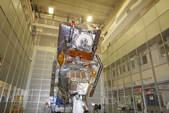
NASA’s next generation Global Precipation Managemnet Measurement (GPM) observatory inside the clean room at NASA Goddard Space Flight Center. GPM is slated to launch In February 2014 and will provide global measurements of rain and snow every 3 hours - as a direct follow-up to NASA’s currently orbiting TRMM satellite; reaching the end of its usable lifetime. Credit: Ken Kremer/kenkremer.com
NASA’s next generation Global Precipitation Measurement (GPM) observatory inside the clean room at NASA Goddard Space Flight Center. GPM is slated to launch In February 2014 and will provide global measurements of rain and snow every 3 hours – as a direct follow-up to NASA’s currently orbiting TRMM satellite; reaching the end of its usable lifetime.
Credit: Ken Kremer/kenkremer.com

“TRMM is reaching the end of its usable lifetime. GPM launches in February 2014 and we hope it has some overlap with observations from TRMM.”

“The Global Precipitation Measurement (GPM) observatory will provide high resolution global measurements of rain and snow every 3 hours,” Dalia Kirschbaum, GPM research scientist, told me at Goddard.

GPM is equipped with advanced, higher resolution radar instruments. It is vital to continuing the TRMM measurements and will help provide improved forecasts and advance warning of extreme super storms like Hurricane Sandy and Super Typhoon Haiyan, Azarbarzin and Kirschbaum explained.

Video Caption: Super Typhoon Haiyan imaged on Nov 6 – 8, 2013 by the Russian Elektro-L satellite operating in geostationary orbit. Credit: Roscosmos via Vitaliy Egorov

The full magnitude of Haiyan’s destruction is just starting to be assessed as rescue teams reach the devastated areas where winds wantonly ripped apart homes, farms, factories, buildings and structures of every imaginable type vital to everyday human existence.

Typhoon Haiyan is moving westward and is expected to forcefully strike central Vietnam in a day or two. Mass evacuations are underway at this time
Ken Kremer

SuperTyphoon Haiyan imaged by the Russian Elektro-L satellite operating in geostationary orbit. Credit: Roscosmos via Vitaliy Egorov
Super Typhoon Haiyan imaged by the Russian Elektro-L satellite operating in geostationary orbit. Credit: Roscosmos via Vitaliy Egorov
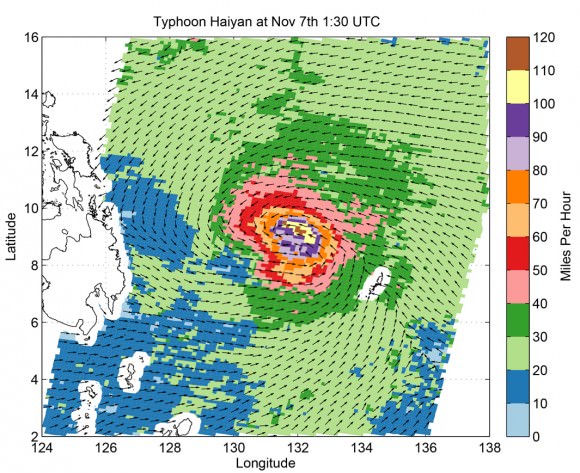
Super Typhoon Haiyan's ocean surface winds were measured by the OSCAT radar scatterometer on the Indian Space Research Organization's (ISRO) OceanSAT-2 satellite at 5:30 p.m. PST on Nov. 6. The colors indicate wind speed and arrows indicate wind direction. Credit: ISRO/NASA/JPL-Caltech
Super Typhoon Haiyan’s ocean surface winds were measured by the OSCAT radar scatterometer on the Indian Space Research Organization’s (ISRO) OceanSAT-2 satellite at 5:30 p.m. PST on Nov. 6. The colors indicate wind speed and arrows indicate wind direction. Credit: ISRO/NASA/JPL-Caltech

A Hybrid Solar Eclipse Seen From Earth… and Space

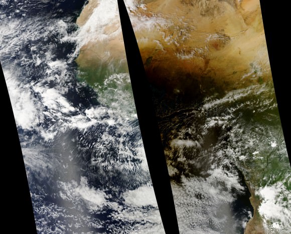
The Elektro-L satellite's view of how the Nov. 3, 2013 solar eclipse effected Earth. Blackness from the eclipse covers Africa. Credit: Elektro-L/Vitaliy EgorovVitaliy Egorov.

The final eclipse for 2013 was a grand event, witnessed across the Atlantic and the heart of Africa this past Sunday. Like so many other photographers along the North American east coast, we were at the ready to greet the partially eclipsed Sun at dawn. And as the shadow of the Moon touched down, teams on land, air and sea were ready to meet with the fleeting umbra as it raced eastward towards sunset over the Horn of Africa region.

But a fleet of spacecraft were also on hand to witness the rare spectacle as well. Turned earthward and sunward, these spacecraft documented not only the passage of the Moon’s shadow over the Earth, but recorded multiple partial solar eclipses from orbit as well.

The first view comes from the Roscosmos Electro-L satellite based in a geostationary orbit over the Indian Ocean:

Electro-L had captured such a view before, during the annular eclipse over Australia earlier this year in May. Roscosmos increased the frame capture rate of Electro-L to twice its usual speed for the sequence. As you watch the Earth pass from a waning gibbous to crescent phase, you can just see the umbra, or central shadow of the Moon, slide into view and come into contact with the sunset terminator over eastern Africa. You can also see the cloud cover that marks the dust storms that plagued eclipse-chasers based around the Lake Turkana region in Kenya.

One of the first public pictures of the umbra of the Moon as seen from space was taken from the Mir space station during a total solar eclipse in 1999. To our knowledge, such a feat has yet to be duplicated aboard the International Space Station. The phase angle of the ISS’s orbit during the eclipse was nearly perpendicular to the Sun-Moon-Earth syzygy, and unfavorable for this particular eclipse.

Thanks to the Russian journalist Vitaliy Egorov for bringing the Electro-L eclipse sequence to the attention of Universe Today!

Next up is a sequence of images from NASA’s Aqua satellite:

Sunday's eclipse and the Moon's umbra as seen from the Aqua satellite. (Credit: NASA/GSFC/Jeff Schmaltz/MODIS Land Rapid Response Team).
Sunday’s eclipse and the Moon’s umbra off of the west coast of Africa as seen from the Aqua satellite. (Credit: NASA/GSFC/Jeff Schmaltz/MODIS Land Rapid Response Team).

Launched in 2002, Aqua is part of the “A-train” (as in “Afternoon”) constellation of Earth-observing satellites. Perched in a low-Earth Sun-synchronous orbit, Aqua caught sight of the umbra of the Moon at around 14:45 UT on Sunday, November 3rd as it raced to make first landfall over the nation of Gabon and awaiting eclipse chasers.

Some Sun observing spacecraft caught sight of the eclipse as well. The European Space Agency’s Proba-2 nabbed three partial solar eclipses from its vantage point in low Earth orbit:

PROBA-2 used its SWAP imager to grab the sequences. Orbiting the Earth once every 99 minutes or 14.5 time a day, these “orbital eclipses” are quick, lasting about 10 minutes each in duration.

Finally, EUMETSAT’s MeteoSat-10 meteorological satellite based in a geostationary orbit over Africa captured an outstanding sequence, showing nearly the entire trek of the umbra across the entire path of the eclipse:

The sequence runs from 7:30 to 18:30 UT on November 3rd. Note how the video shows the shadow fade in and sharpen as the eclipse touches down off of the US East Coast and intensifies from an annular to total along the first 15 seconds of its track, only to speed up and flatten towards sunset over Africa. And all in six seconds!

And back here on Earth, we couldn’t resist stitching together the bounty from our own minor eclipse expedition for a stop-motion view of the partially eclipsed Sun rising over the Vehicle Assembly Building at the Kennedy Space Center in Florida:

We’d like to also mention a photo that isn’t a “solar eclipse seen from space…” Y’know the one, which shows the Earth, the Moon’s shadow, and a totally-eclipsed Sun, against a star dappled Milky Way. We won’t dignify it with a link. This has already been debunked by Bad Astronomer himself Phil Plait, but the bogus pic now seems to make its rounds across ye’ ole Web now during every eclipse. Seriously? Do we all crave “link juice” that bad? There are lots of real awesome eclipse photos out there, from Earth & beyond! Please, do your part to tell that well meaning friend/coworker/relative/stranger on Twitter that this “ultimate eclipse photo…” isn’t.

How rare are hybrid solar eclipses? Well, the next solar eclipse that is both annular and total along its track occurs over southeast Asia on April 20th, 2023. It’s interesting to note that this past weekend’s eclipse may have been the first sunrise solar eclipse over the VAB since it was built in 1966. Eclipses in the same 18 years and 11 days- long saros cycle repeat, but move about 120 degrees westward. Thus, follow an eclipse cycle through a “triple saros”— known as an “Exeligmos,” an ultimate scrabble word if you can land it on a triple word score! —and an eclipse’s geometry will roughly line back up over a 54 year 33 day long span. Saros 143 produced a an eclipse crossing a similar path on October 2nd, 1959 (before the VAB was built!) and will repeat its Atlantic sunrise performance on December 6th, 2067! Let’s see, by then I’ll be…

Antarctic Sea Ice Takes Over More Of The Ocean Than Ever Before

Antarctica's sea ice on Sept. 22, 2013. Scientists say there was more ice on the ocean then than in any time in recorded satellite history. Data came from the Advanced Microwave Scanning Radiometer 2 (AMSR2) sensor on Japan’s Global Change Observation Mission 1st-Water (GCOM-W1) satellite. You can see the land in dark gray and ice shelves in light gray. The yellow line represents the average distribution of sea ice between 1981 and 2000. Credit: NASA/Jesse Allen, using data from the Advanced Microwave Scanning Radiometer 2 (AMSR2) sensor on the Global Change Observation Mission 1st-Water (GCOM-W1) satellite.

Antarctica’s sea ice is creeping further out in the ocean! New data from a Japanese satellite shows that sea ice surrounding the southern continent in late September reached out over 7.51 million square miles (19.47 million square kilometers).

The extent — a slight increase over 2012’s record of 7.50 million square miles (19.44 million square km) — is the largest recorded instance of Antarctica sea ice since satellite records began, NASA said. Data was recorded using the Advanced Microwave Scanning Radiometer 2 (AMSR2) sensor on the Global Change Observation Mission 1st-Water (GCOM-W1) satellite.

“While researchers continue to study the forces driving the growth in sea ice extent, it is well understood that multiple factors—including the geography of Antarctica, the region’s winds, as well as air and ocean temperatures—all affect the ice,” NASA stated.

Update — see below for a more detailed description of why this is an important clue that climate change IS happening.

“Geography and winds are thought to be especially important. Unlike the Arctic, where sea ice is confined in a basin, Antarctica is a continent surrounded by open ocean. Since its sea ice is unconfined, it is particularly sensitive to changes in the winds. As noted by the National Snow and Ice Data Center, some research has suggested that changes in Antarctic sea ice are caused in part by a strengthening of the westerly winds that flow unhindered in a circle above the Southern Ocean.”

For those thinking that increased sea ice means we can relax about climate change, this humorous video explains the difference between land ice (glaciers) and sea ice (which is generated from snow, rainfall and fresh water). It’s definitely worth four minutes of your time. The part about sea ice starts around 2:45.

UPDATE: Just to clarify:

Here’s what the graphic says: “The water around Antarctica is more fresh than it has been in previous years because of increased snow and rainfall as well as in increased contribution of fresh water from melting land ice. This fresh cold water is less dense than the warmer, saltier water below. Previously, that warm salty water would rise, melting the sea ice. But now, bcaus of the lighter fresh water on top, there is less mixing of the ocean’s layer and the surface stays cooler longer. “

And so, there is increased fresh water because of the melting land ice – due to climate change. There is a fundamental difference between sea ice and land ice. Antarctic land ice is the ice which has accumulated over thousands of years on the Antarctica landmass through snowfall. Antarctic sea ice is entirely different as it is ice which forms in salt water during the winter and almost entirely melts again in the summer.

Importantly, when land ice melts and flows into the oceans global sea levels rise on average; when sea ice melts sea levels do not change measurably but other parts of the climate system are affected, like increased absorption of solar energy by the darker oceans.

See this article on SkepticalScience for additional information.

Source: NASA Earth Observatory

NASA’s Juno Spacecraft Returns 1st Flyby images of Earth while Sailing On to Jupiter

Juno swoops over Argentina This reconstructed day side image of Earth is one of the 1st snapshots transmitted back home by NASA’s Jupiter-bound Juno spacecraft during its speed boosting flyby on Oct. 9, 2013. It was taken by the probes Junocam imager and methane filter at 12:06:30 PDT and an exposure time of 3.2 milliseconds. Juno was flying over South America and the southern Atlantic Ocean. The coastline of Argentina is visible at top right. Credit: NASA/JPL/SwRI/MSSS/Ken Kremer

Following the speed boosting slingshot of Earth on Wednesday, Oct. 9, that sent NASA’s Juno orbiter hurtling towards Jupiter, the probe has successfully transmitted back data and the very first flyby images despite unexpectedly going into ‘safe mode’ during the critical maneuver.

Juno is transmitting telemetry today,” spokesman Guy Webster, of NASA’s Jet Propulsion Lab (JPL), told me in a phone interview late today (Oct. 10), as Juno continues sailing on its 2.8 Billion kilometer (1.7 Billion mile) outbound trek to the Jovian system.

The new images of Earth captured by the Junocam imager serves as tangible proof that Juno is communicating.

“Juno is still in safe mode today (Oct. 10),” Webster told Universe Today.

“Teams at mission control at JPL and Lockheed Martin are actively working to bring Juno out of safe mode. And that could still require a few days,” Webster explained.

Lockheed Martin is the prime contractor for Juno.

The initial raw images of Earth snapped by the craft’s Junocam imager were received by ground stations late today.

See above a day light image mosaic which I reconstructed and realigned based on the original raw image (see below) taken with the camera’s methane filter on Oct. 9 at 12:06:30 PDT (3:06:30 PM EST). Juno was to be flying over South America and the southern Atlantic Ocean.

This day side raw image of Earth is one of the 1st snapshots transmitted back home today by NASA’s Juno spacecraft during its speed boosting flyby on Oct. 9, 2013. It was taken by the probes Junocam imager and methane filter at 12:06:30 PDT and an exposure time of 3.2 ms. Credit: NASA/JPL/SwRI/MSSS
This day side raw image of Earth is one of the 1st snapshots transmitted back home today by NASA’s Juno spacecraft during its speed boosting flyby on Oct. 9, 2013. It was taken by the probes Junocam imager and methane filter at 12:06:30 PDT and an exposure time of 3.2 milliseconds. Juno was due to be flying over South America and the southern Atlantic Ocean. Credit: NASA/JPL/SwRI/MSSS

Juno performed a crucial swingby of Earth on Wednesday that accelerated the probe by 16330 MPH to enable it to arrive in orbit around Jupiter on July 4, 2016.

However the gravity assist maneuver did not go entirely as planned.

Shortly after Wednesday’s flyby, Juno Project manager Rick Nybakken, of JPL, told me in a phone interview that Juno had entered safe mode but that the probe was “power positive and we have full command ability.”

“After Juno passed the period of Earth flyby closest approach at 12:21 PM PST [3:21 PM EDT] and we established communications 25 minutes later, we were in safe mode,” Nybakken explained.

The safe mode was triggered while Juno was in an eclipse mode, the only eclipse it will experience during its entire mission.

The Earth flyby did accomplish its objective by placing the $1.1 Billion Juno spacecraft exactly on course for Jupiter as intended.

“We are on our way to Jupiter as planned!”

“None of this affected our trajectory or the gravity assist maneuver – which is what the Earth flyby is,” Nybakken stated.

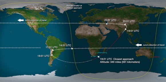
Juno’s closest approach was over South Africa at about 561 kilometers (349 miles).

Juno’s flight track above Earth during Oct. 9, 2013 flyby. Credit: NASA/JPL

During the flyby, the science team also planned to observe Earth using most of Juno’s nine science instruments since the slingshot also serves as a key test of the spacecraft systems and the flight operations teams.

Juno also was to capture an unprecedented new movie of the Earth/Moon system.

Many more images were snapped and should be transmitted in coming days that eventually will show a beautiful view of the Earth and Moon from space.

“During the earth flyby we have most of our instruments on and will obtain a unique movie of the Earth Moon system on our approach, Juno principal investigator Scott Bolton told me. Bolton is from the Southwest Research Institute (SwRI), San Antonio, Texas.

“We will also calibrate instuments and measure earth’s magnetosphere, obtain closeup images of the Earth and the Moon in UV [ultraviolet] and IR [infrared],” Bolton explained to Universe Today.

Juno is approaching the Earth from deep space, from the sunlit side.

“Juno will take never-before-seen images of the Earth-moon system, giving us a chance to see what we look like from Mars or Jupiter’” says Bolton.

Here is a description of Junocam from the developer – Malin Space Science Systems

“Like previous MSSS cameras (e.g., Mars Reconnaissance Orbiter’s Mars Color Imager) Junocam is a “pushframe” imager. The detector has multiple filter strips, each with a different bandpass, bonded directly to its photoactive surface. Each strip extends the entire width of the detector, but only a fraction of its height; Junocam’s filter strips are 1600 pixels wide and about 155 rows high. The filter strips are scanned across the target by spacecraft rotation. At the nominal spin rate of 2 RPM, frames are acquired about every 400 milliseconds. Junocam has four filters: three visible (red/green/blue) and a narrowband “methane” filter centered at about 890 nm.”

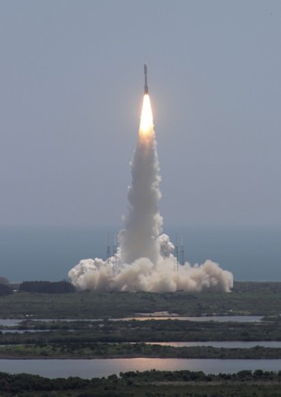
Juno soars skyward to Jupiter on Aug. 5, 2011 from launch pad 41 at Cape Canaveral Air Force Station at 12:25 p.m. EDT. View from the VAB roof. Credit: Ken Kremer/kenkremer.com
Juno launched atop an Atlas V rocket two years ago from Cape Canaveral Air Force Station, FL, on Aug. 5, 2011 on a journey to discover the genesis of Jupiter hidden deep inside the planet’s interior.

During a one year long science mission – entailing 33 orbits lasting 11 days each – the probe will plunge to within about 3000 miles of the turbulent cloud tops and collect unprecedented new data that will unveil the hidden inner secrets of Jupiter’s origin and evolution.

NBC News has also featured this Juno story – here

Read more about Juno’s flyby in my articles – here and here

Stay tuned here for continuing Juno, LADEE, MAVEN and more up-to-date NASA news.

Ken Kremer

NASA’s Juno probe Gets Gravity Speed Boost during Earth Flyby But Enters ‘Safe Mode’

The first color reconstruction of the Moon by Adam Hurcewicz

Developing story – NASA’s Juno-bound Jupiter orbiter successfully blazed past Earth this afternoon (Oct. 9) and gained its huge and critical gravity assisted speed boost that’s absolutely essential to reach the Jovian system in 2016.

However, Juno’s project manager Rick Nybakken told me moments ago that the Juno spacecraft unexpectedly entered ‘safe mode’ during the fly by maneuver and the mission teams are assessing the situation.

But the very good news is “Juno is power positive at this time. And we have full command ability,” said Nybakken in an exclusive phone interview with me.

“After Juno passed the period of Earth flyby closest approach at 12:21 PM PST [3:21 PM EDT] and we established communications 25 minutes later, we were in safe mode,” Nybakken told me. Nybakken is the Juno mission project manager at NASA’s Jet Propulsion Lab in Pasadena, CA.

Furthermore, the Earth flyby did place the $1.1 Billion Juno spacecraft exactly on course for Jupiter as intended.

“We are on our way to Jupiter as planned!”

“None of this affected our trajectory or the gravity assist maneuver – which is what the Earth flyby is.”

Juno’s closest approach was over South Africa at about 500 kilometers (350 miles).

“Juno hit the target corridor within 2 km of the aim point,” Nybakken elaborated to Universe Today.

Juno needs the 16,330 mph velocity boost from the Earth swingby because the Atlas V launcher was not powerful enough to hurtle the 8000 pound (3267 kg) craft fast enough on a direct path to Jupiter.

And the team is in full radio contact with the probe. Safe mode is a designated protective state.

“Prior to the eclipse, which was a few minutes earlier than closest approach, the spacecraft was ‘nominal’. When we came out of the eclipse Juno was in safe mode,” Nybakken stated.

“We are going through safe mode diagnostics steps right now.”

“We have established full uplink and downlink. And we have full command ability of the spacecraft.”

First JunoCam image of the day! Taken at 11:07 UTC when Juno was 206,000 Kilometers from the Moon.

Speed boosting slingshots have been used on numerous planetary missions in the past

The spacecraft’s power situation and health is as good as can be expected.

“Juno is power positive at this time and sun pointed and stable. So we are very pleased about that,” Nybakken explained.
I asked if Juno had ever entered ‘safe mode’ before?

“We have never been in safe mode before. We are in a safe, stable state.”

“We are investigating this,” said Nybakken.

Credit: NASA/JPL
Credit: NASA/JPL

Today’s (Oct. 9) Earth flyby is the only time the spacecraft experiences an eclipse period during Juno’s entire five year and 1.7 Billion mile (2.8 Billion km) trek to Jupiter, the largest planet in our solar system.

When it finally arrives at Jupiter on July 4, 2016, Juno will become the first polar orbiting spacecraft at the gas giant.

NASA’s Juno spacecraft blasted off atop an Atlas V rocket two years ago from Cape Canaveral Air Force Station, FL, on Aug. 5, 2011 on a journey to discover the genesis of Jupiter hidden deep inside the planet’s interior.

Juno soars skyward to Jupiter on Aug. 5, 2013 from launch pad 41 at Cape Canaveral Air Force Station at 12:25 p.m. EDT. View from the VAB roof. Credit: Ken Kremer/kenkremer.com
Juno soars skyward to Jupiter on Aug. 5, 2011 from launch pad 41 at Cape Canaveral Air Force Station at 12:25 p.m. EDT. View from the VAB roof. Credit: Ken Kremer/kenkremer.com
The science team had also hoped to use the on board JunoCam imager to make a cool and unprecedented movie of Earth as it approached from the sunlit side – showing the passage as though you were a visitor from outer space.

I had an inkling that something might be amiss this afternoon when no images of Earth appeared on the Juno mission website.

So I asked the status.

“We don’t know yet if any images of Earth were collected. We hope to know soon.”

Juno flew past the Moon before the gravity assist slingshot with Earth. And it did manage to successfully capture several lunar images. See the images herein.

Read more about Juno in my flyby preview story – here.

Note: Due to the continuing chaos resulting from the US government partial shutdown caused by gridlocked politico’s in Washington DC, NASA public affairs remains shut down and is issuing no official announcements on virtually anything related to NASA! This pertains to Juno’s flyby, LADEE’s lunar arrival on Oct. 6, MAVEN’s upcoming launch in November, Cygnus at the ISS, and more!

Stay tuned here for continuing Juno, LADEE, MAVEN and more up-to-date NASA news.

Ken Kremer

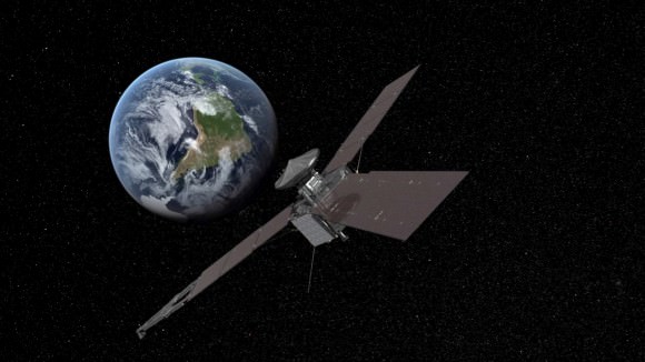
NASA’s Juno Jupiter-bound space probe will fly by Earth for essential speed boost on Oct 9, 2013. Credit: NASA/JPL

Juno Careening to Earth for Critical Flyby Boost and Cool Movie Making on Oct. 9 – Watch SLOOH Live

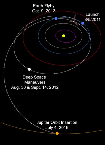
Trajectory Map of Juno’s Earth Flyby on Oct. 9, 2013. The Earth gravity assist is required to accelerate Juno’s arrival at Jupiter on July 4, 2016 and will captured unprecedented movie of Earth/Moon system. Credit: NASA/JPL

Trajectory Map of Juno’s Earth Flyby on Oct. 9, 2013
The Earth gravity assist is required to accelerate Juno’s arrival at Jupiter on July 4, 2016 and will capture an unprecedented movie of the Earth/Moon system. Credit: NASA/JPL
Details on how to watch via Slooh – see below [/caption]

NASA’s solar powered Jupiter-bound Juno orbiter is careening towards Earth for an absolutely critical gravity assisted fly by speed boost while capturing an unprecedented movie view of the Earth/Moon system – on its ultimate quest to unveiling Jupiter’s genesis!

“Juno will flyby Earth on October 9 to get a gravity boost and increase its speed in orbit around the Sun so that it can reach Jupiter on July 4, 2016,” Juno chief scientist Dr. Scott Bolton told Universe Today in an exclusive new Juno mission update – as the clock is ticking to zero hour. “The closest approach is over South Africa.”

All this ‘high frontier’ action comes amidst the utterly chaotic US government partial shutdown, that threatened the launch of the MAVEN Mars orbiter, has halted activity on many other NASA projects and stopped public announcements of the safe arrival of NASA’s LADEE lunar orbiter on Oct. 6, Juno’s flyby and virtually everything else related to NASA!

Bolton confirmed that the shutdown fortunately hasn’t altered or killed Juno’s flyby objectives. And ops teams at prime contractor Lockheed Martin have rehearsed and all set.

And some more good news is that Slooh will track the Juno Earth Flyby “LIVE” – for those hoping to follow along. Complete details below!

“The shutdown hasn’t affected our operations or plans, Bolton told me. Bolton is Juno’s principal investigator from the Southwest Research Institute (SwRI), San Antonio, Texas.

“Juno is 100% healthy.”

“But NASA is unable to participate in our public affairs and press activities,” Bolton elaborated.

NASA’s Juno Jupiter-bound space probe will fly by Earth for essential speed boost on Oct 9, 2013. Credit: NASA/JPL

97% of NASA’s employees are furloughed – including public affairs – due to the legal requirements of the shutdown!

Credit: NASA/JPL
Credit: NASA/JPL
Juno will also capture an unprecedented new movie of the Earth/Moon system.

A full up science investigation of our Home Planet by Juno is planned, that will also serve as a key test of the spacecraft and its bevy of state of the art instruments.

“During the earth flyby we have most of our instruments on and will obtain a unique movie of the Earth Moon system on our approach.

“We will also calibrate instuments and measure earth’s magnetosphere, obtain closeup images of the Earth and the Moon in UV [ultraviolet] and IR [infrared],” Bolton explained to Universe Today.

The flyby will accelerate the spacecraft’s velocity by 16,330 mph.

Where is the best view of Juno’s flyby, I asked?

“The closest approach is over South Africa and is about 500 kilometers [350 miles],” Bolton replied.

The time of closest approach is 3:21 p.m. EDT (12:21 PDT / 19:21 UTC) on Oct. 9, 2013

Watch this mission produced video about Juno and the Earth flyby:

Video caption: On Oct. 9, 2013, NASA’s Jupiter-bound Juno spacecraft is making a quick pass to get a gravity boost from the mother planet. Dr. Scott Bolton of Southwest Research Institute® is the Juno mission principal investigator, leading an international science team seeking to answer some fundamental questions about the gas giant and, in turn, about the processes that led to formation of our solar system.

NASA’s Juno spacecraft blasted off atop an Atlas V rocket two years ago from Cape Canaveral Air Force Station, FL, on Aug. 5, 2011 to begin a 2.8 billion kilometer science trek to discover the genesis of Jupiter hidden deep inside the planet’s interior.

Juno is on a 5 year and 1.7 Billion mile (2.8 Billion km) trek to the largest planet in our solar system. When it arrives at Jupiter on July 4, 2016, Juno will become the first polar orbiting spacecraft at the gas giant.

Juno’s flight track above Earth during Oct. 9, 2013 flyby. Credit: NASA/JPL

During a one year science mission – entailing 33 orbits lasting 11 days each – the probe will plunge to within about 3000 miles of the turbulent cloud tops and collect unprecedented new data that will unveil the hidden inner secrets of Jupiter’s genesis and evolution.

The goal is to find out more about the planets origins, interior structure and atmosphere, observe the aurora, map the intense magnetic field and investigate the existence of a solid planetary core

Why does Juno need a speed boost from Earth?

“A direct mission to Jupiter would have required about 50 percent more fuel than we loaded,” said Tim Gasparrini, Juno program manager for Lockheed Martin Space Systems, in a statement.

“Had we not chosen to do the flyby, the mission would have required a bigger launch vehicle, a larger spacecraft and would have been more expensive.”

Juno soars skyward to Jupiter on Aug. 5, 2011 from launch pad 41 at Cape Canaveral Air Force Station at 12:25 p.m. EDT. View from the VAB roof. Credit: Ken Kremer/kenkremer.com

Viewers near Cape Town, South Africa will have the best opportunity to view the spacecraft traveling across the sky.

Juno itself will most likely not be visible to the unaided eye, but binoculars or a small telescope with a wide field should provide an opportunity to view, according to a Slooh statement.

Slooh will track Juno live on October 9th, 2013.

Check here for international starting times: http://goo.gl/7ducFs – and for the Slooh broadcast hosted by Paul Cox.

Viewers can view the event live on Slooh.com using their computer or mobile device, or by downloading the free Slooh iPad app in the iTunes store. Questions can be asked during the broadcast via Twitter by using the hashtag #nasajuno -says Slooh.

Amidst the government shutdown, Juno prime contractor Lockheed Martin is working diligently to ensure the mission success.

Because there are NO 2nd chances!

“The team is 100 percent focused on executing the Earth flyby successfully,” said Gasparrini.

“We’ve spent a lot of time looking at possible off-nominal conditions. In the presence of a fault, the spacecraft will stay healthy and will perform as planned.”

Stay tuned here for continuing Juno, LADEE, MAVEN and more up-to-date NASA news.

And be sure to check back here for my post-flyby update.

What’s not at all clear is whether Juno will detect any signs of ‘intelligent life’ in Washington D.C.!

Ken Kremer

…………….

Learn more about Juno, LADEE, MAVEN, Curiosity, Mars rovers, Cygnus, Antares, SpaceX, Orion, the Gov’t shutdown and more at Ken’s upcoming presentations

Oct 8: “NASA’s Historic LADEE Lunar & Antares/Cygnus ISS Rocket Launches from Virginia”& “Curiosity, MAVEN, Juno and Orion updates”; Princeton University, Amateur Astronomers Assoc of Princeton (AAAP), Princeton, NJ, 8 PM

Awesome Photo: Aurora, Airglow, City Lights and Shining Stars

Photo taken by ESA astronaut Luca Parmitano on Sept. 5, 2013 (ESA/NASA)

Italian astronaut Luca Parmitano shares a lot of fantastic photos taken from his privileged position 260 miles up aboard the Space Station, orbiting the planet 16 times a day. This is his latest, a stunning view of nighttime city lights spread out beneath a glowing dome of ghostly airglow and shimmering aurorae, with a backdrop of brightly shining stars. The dark silhouette of a solar array is in the foreground at right.

And in case you were wondering, yes, astronauts certainly can see stars while in space. A lot of them, in fact. (Except up there, they don’t twinkle… but they’re no less beautiful!)

“Every time we look into the sky and we admire the same stars, we share the same experience with all those who still know how to dream.”

– Luca Parmitano

Luca Parmitano is the first of ESA’s new generation of astronauts to fly into space. The current mission, Volare, is ESA’s fifth long-duration Space Station mission. During his six-month-long stay aboard the ISS, Luca has been conducting research for ESA and international partners as well as taken many photographs of our planet, sharing them on Twitter, Flickr, and the Volare mission blog.

See this and more photos taken by Luca on the Volare Flickr page here.

Image credit: ESA/NASA

Could The U.S. Government Shutdown Hammer Earth and Mars Missions?

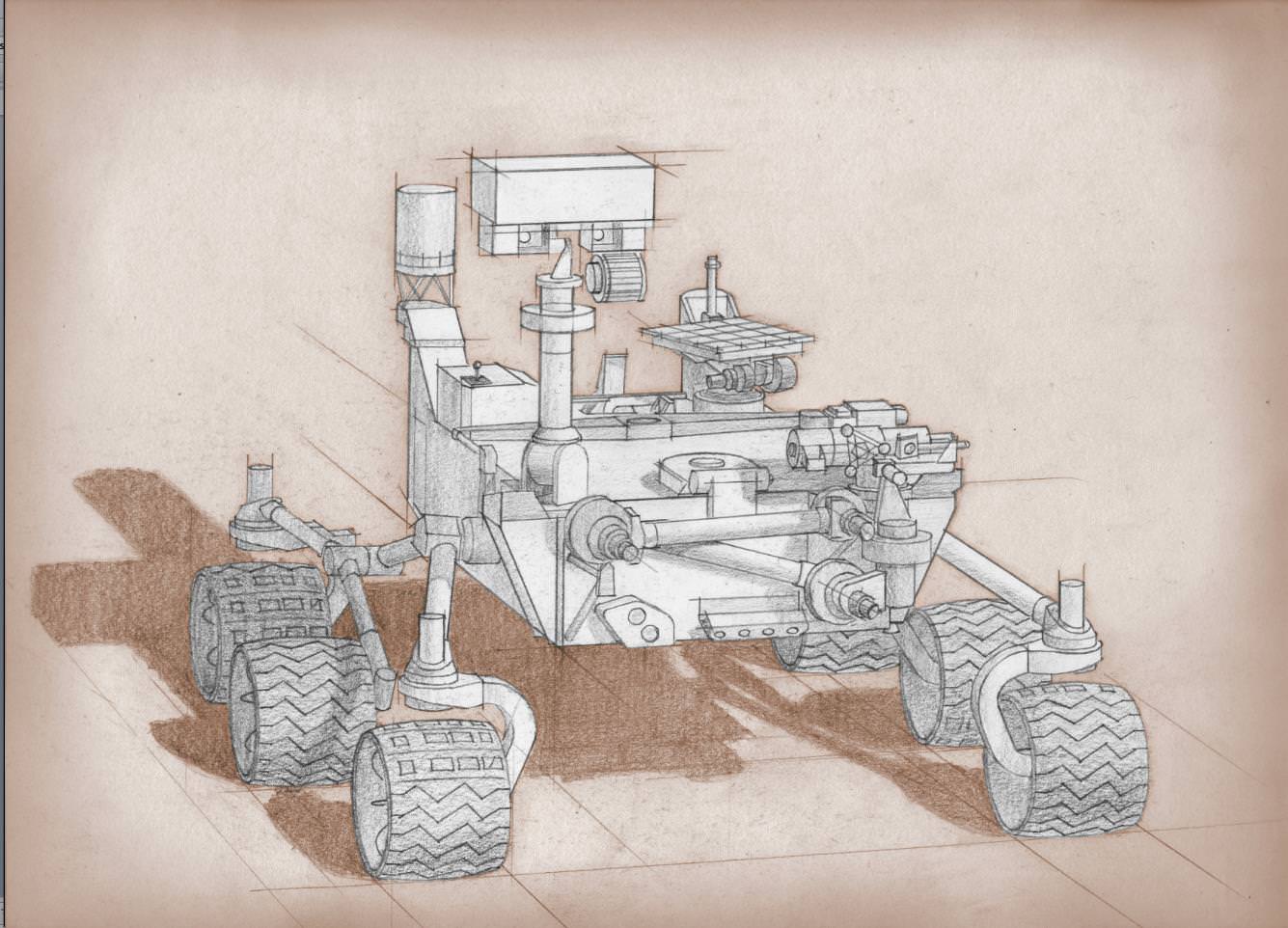
Artist's conception of the Mars 2020 rover. Credit: NASA

As Day 2 of the United States government shutdown continues, some short-term effects are already in evidence when it comes to Earth and space.

Most of the NASA and National Oceanic and Atmospheric Administration (NOAA) websites are offline. Social media updates are silent. At NASA, 97% of agency employees are off work and media reports indicate that 55% of NOAA’s employees are furloughed.

If the shutdown lasts for very long, however, long-term programs could feel the pain. This includes a couple of Mars missions NASA is developing, as well as Earth-based climate research and satellite observation from NOAA.

Mars 2020

A twin rover to Mars Curiosity, called Mars 2020 for now, is expected to leave for the Red Planet in 2020 and do investigations into past life and habitability. Planning is still in the early stages, but an announcement of opportunity for science investigators was supposed to happen on Oct. 8. Notices of intent were due Oct. 15.

“The preproposal conference, scheduled for 10/8, may be rescheduled and the due date for NOIs (currently 10/15) could be delayed, if the government is still shut down closer to those dates,” NASA officials wrote in an update before the shutdown on Monday.

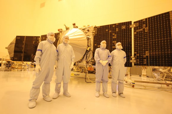
MAVEN team members, including chief scientist Bruce Jakosky (2nd from left)  pose with spacecraft inside the cleanroom at the Kennedy Space Center on Sept. 27, 2013. Credit: Ken Kremer/kenkremer.com
MAVEN team members, including chief scientist Bruce Jakosky (2nd from left) pose with spacecraft inside the cleanroom at the Kennedy Space Center on Sept. 27, 2013. Credit: Ken Kremer/kenkremer.com

MAVEN

As widely reported yesterday, the next Mars orbiter from NASA is expected to lift off from Earth on Nov. 18. Now, however, preparatory work has ceased and there is some concern from team members that it will miss the launch window, which extends into December. At worst, this means MAVEN’s launch could be delayed until 2016, when the next opportunity opens.

“The hardware is being safed, meaning that it will be put into a known, stable, and safe state,” Bruce Jakosky, MAVEN’s principal investigator, told Universe Today‘s Ken Kremer yesterday. “We’ll turn back on when told that we can. We have some margin days built into our schedule.”

NOAA

As with NASA, NOAA is keeping up with mission-critical activities — which in their case, includes weather forecasting. Long-term climate research, however, is reportedly being shelved.

“For example, Harold Brooks, a top tornado researcher who works at the National Severe Storms Laboratory in Norman, Okla., reported his furlough notice on Facebook on Tuesday,” Climate Central wrote on Oct. 1. “Much of the staff at NOAA’s Earth Systems Research Lab and the Geophysical Fluid Dynamics Laboratory, except for positions related to maintaining computing resources, have also been furloughed. Those two labs are heavily involved in NOAA’s climate research programs.”

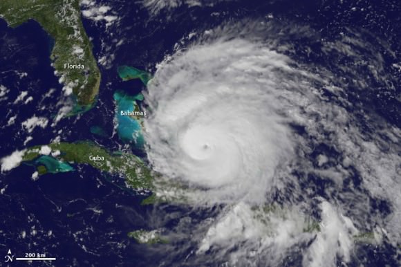
A view of Hurricane Irene taken by the GOES satellite at 2:55 p.m. Eastern Daylight Time on August 24, 2011. Credit: NASA

Observers are also worried that a lengthy shutdown could push back the time when new weather satellites become available. There have been multiple reports about a “weather satellite gap” coming in the United States as many of NOAA’s geostationary and polar-orbiting satellites are nearing the end of their expected lives. The Subcommittees on Oversight and Environment held hearings into this issue in September.

What’s still online?

These are some of the programs that are still happening at NASA and NOAA:

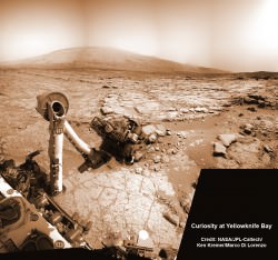
NASA’s Curiosity rover reaches out in ‘handshake’ like gesture with dramatic scenery of Mount Sharp in the background. This mosaic of images was snapped by Curiosity on Sol 262 (May 2, 2013) and shows her flexing the robotic arm. Two drill holes are visible on the surface bedrock below the robotic arm’s turret. Credit: NASA/JPL-Caltech/Ken Kremer-(kenkremer.com)/Marco Di Lorenzo

NASA:

  • Bare-bones management on programs such as the International Space Station and several robotic missions that are already in operation (such as the Lunar Atmosphere and Dust Environment Explorer (LADEE).
  • Certain missions are in critical phases that could be hurt if work stops, such as the James Webb Space Telescope, which is undergoing cryogenic testing on some of its instruments.
  • Several missions run out of the Jet Propulsion Laboratory and Applied Physics Laboratory are still running as usual, according to the Planetary Society, as these receive contract money from NASA; this means Mars Curiosity is still working, for example.
  • The Mars Reconnaissance Orbiter’s HiRISE camera is still snapping pictures, its Twitter account reported, which is positive given that it was intended to snap shots of Comet ISON during its closest approach to Mars yesterday.
  • The decades-long Landsat Earth observation program is still operating, according to The Atlantic, with data being sent back to Earth as usual. The difference is this information won’t be packaged as usual until government operations restart.

NOAA (all information according to this Department of Commerce document):

  • The Office of Oceanic and Atmospheric Research will keep 73 employees on board “to ensure continuity of crucial long-term historical climate records, and real-time regular research to support ongoing weather and air quality prediction services,” NOAA said.
  • 184 employees will stay with the Environmental Satellite and Data Information Service for command and control of several satellites for NOAA and the Department of Defense.
  • 474 employees will remain with the National Marine Fisheries Service. 174 are funded in another form besides appropriations. The others are a mix of law enforcement, fisheries management and property protection officials.
  • 490 employees are with the Office of Marine and Aviation Operations for observational data collection related to weather forecasting.
  • 173 employees are with the National Ocean Service. 17 are funded outside of appropriations, while the 156 remaining “are required to protect against imminent and significant threats to life and property by supporting safe maritime commerce in U.S. waters, including real-time water level data for ships entering U.S. ports, critical nautical chart updates, and accurate position information,” NOAA stated. Some are also monitoring marine health aspects such as algal blooms.
  • There are 19 IT-related employees and 20 employees providing support services.
  • The large bulk of employees still at work, 3,935 people, are with the National Weather Service to keep up weather forecasting.

There’s no word yet on when government employees could go back to work. Congress representatives are jousting over the implementation of a spending bill to keep the money flowing to government departments. One big issue: whether to include the Affordable Care Act, sometimes dubbed Obamacare, in the bill.

Another deadline is looming, too. Treasury Secretary Jack Lew has warned repeatedly that on Oct. 17, if the debt ceiling is not raised, the United States government may default on some financial obligations.

Doubly Historic Day for Private Space: Cygnus docks at Station & Next Gen Falcon 9 Soars

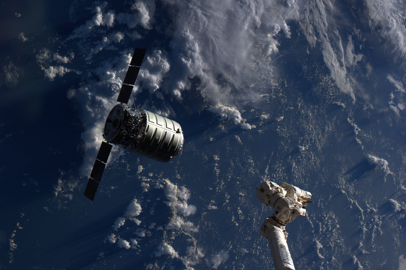
The Cygnus cargo spacecraft is just a few feet away from the International Space Station's Canadarm2 during rendezvous and berthing on Sept 29, 2013. Credit: NASA

The Cygnus cargo spacecraft is just a few feet away from the International Space Station’s Canadarm2 during rendezvous and berthing on Sept 29, 2013. Credit: NASA
Updated – See Falcon 9 launch video below[/caption]

Today (Sept. 29) was a doubly historic day for private spaceflight! And a boon to NASA as well!

Early this morning the Orbital Sciences Cygnus commercial cargo ship docked at the International Space Station (ISS) speeding along some 250 miles (400 km) overhead in low Earth orbit.

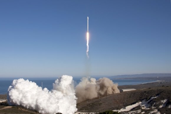
Barely a few hours later the Next Generation commercial SpaceX Falcon 9 rocket soared to space on a demonstration test flight from the California coast carrying a Canadian satellite to an elliptical earth orbit.

These missions involved the dramatic maiden flights for both Cygnus and the upgraded Falcon 9.

And both were high stakes endeavors, with literally billions of dollars and the future of commercial spaceflight, as well as the ISS, on the line. Their significance cannot be overstated!

Falcon 9 lifts off from SpaceX’s pad at Vandenberg on Sept 29, 2013, carrying Canada's CASSIOPE satellite to orbit. Credit: SpaceX
Falcon 9 lifts off from SpaceX’s pad at Vandenberg on Sept 29, 2013, carrying Canada’s CASSIOPE satellite to orbit. Credit: SpaceX

Both Cygnus and Falcon 9 were developed with seed money from NASA in a pair of public-private partnerships between NASA and Orbital Sciences and SpaceX under NASA’s COTS commercial transportation initiative aimed at fostering the development of America’s private space industry to deliver critical and essential supplies to the ISS.

The powerful new Falcon 9 will also be used to send cargo to the ISS.

America completely lost its capability to send humans and cargo to the ISS when NASA’s space shuttles were retired in 2011. Orbital Sciences and SpaceX were awarded NASA contracts worth over $3 Billion to restore the unmanned cargo resupply capability over 20 flights totally.

The Cygnus spacecraft put on a spectacular space ballet – and was no worse for the wear after its docking was delayed a week due to an easily fixed communications glitch.

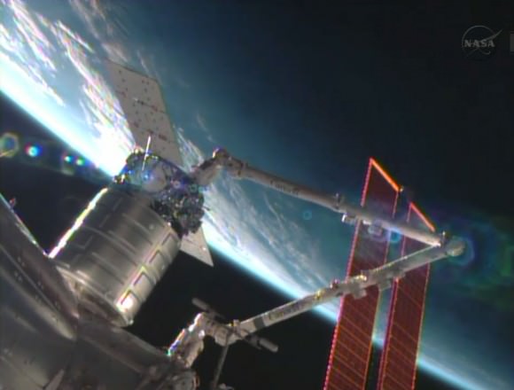
The Cygnus commercial resupply craft is installed by the Canadarm2 to the Harmony node. Credit: NASA TV
The Cygnus commercial resupply craft is installed by the Canadarm2 to the Harmony node.
Credit: NASA TV

Cygnus is a privately developed resupply vessel built by Orbital Sciences Corp and Thales Alenia Space that is a crucial railroad to orbit for keeping the massive orbital lab complex well stocked with everyday essentials and science experiments that are the purpose of the ISS.

Cygnus was grappled in free drift by Expedition 37 space station astronauts Luca Parmitano and Karen Nyberg at about 7 a.m. EDT Sunday morning.

The pair were working at two robotics work stations from inside the Cupola and Destiny modules. They used the stations 57 foot long Canadarm2 to snare Cygnus at a distance of about 30 feet (10 meters). They gradually motioned the arm closer.

Running a bit ahead of schedule they successfully berthed Cygnus at the earth facing port of the Harmony module by about 8:44 a.m. EDT.

Cygnus was launched to orbit on its inaugural flight on Sept. 18 atop Orbital’s commercial Antares rocket from NASA’s Wallops Flight Facility on the Eastern shore of Virginia.

Sept. 22 had been the initially targeted station docking date for this demonstration mission.

Hatches to Cygnus will be opened on Monday, Sept. 30 after completing leak checks.

“Today, with the successful berthing of the Orbital Sciences Cygnus cargo module to the ISS, we have expanded America’s capability for reliably transporting cargo to low-Earth orbit, “ said NASA Admisistrator Charles Bolden in a statement.

“It is an historic milestone as this second commercial partner’s demonstration mission reaches the ISS, and I congratulate Orbital Sciences and the NASA team that worked alongside them to make it happen.”

“Orbital joins SpaceX in fulfilling the promise of American innovation to maintain America’s leadership in space. As commercial partners demonstrate their new systems for reaching the Station, we at NASA continue to focus on the technologies to reach an asteroid and Mars,” said Bolden.

Cygnus delivers about 1,300 pounds (589 kilograms) of cargo, including food, clothing, water, science experiments, spare parts and gear to the Expedition 37 crew.

The upgraded SpaceX Falcon 9 blasted off from Space Launch Complex 4 at Vandenberg Air Force Base in California at 9 a.m. PDT (12 p.m. EDT).

Here’s a video of the launch:

It successfully deployed Canada’s 1,060 pound (481 kg) Cascade, Smallsat, and Ionospheric Polar Explorer (CASSIOPE) weather satellite and several additional small satellites.

This powerful new version of the Falcon 9 dubbed v1.1 is powered by a cluster of nine of the new Merlin 1D engines that are about 50% more powerful compared to the standard Merlin 1C engines and can therefore boost a much heavier cargo load to the ISS and beyond.

The next generation Falcon 9 is a monster. It’s much taller than a standard Falcon 9 – some 22 stories vs. 13.

It could launch from Cape Canaveral as early as this Fall.

Ken Kremer

…………….

Learn more about Cygnus, Antares, SpaceX, Curiosity, Mars rovers, MAVEN, Orion, LADEE and more at Ken’s upcoming presentations

Oct 3: “Curiosity, MAVEN and the Search for Life on Mars – (3-D)”, STAR Astronomy Club, Brookdale Community College & Monmouth Museum, Lincroft, NJ, 8 PM

Oct 8: NASA’s Historic LADEE Lunar & Antares/Cygnus ISS Rocket Launches from Virginia”; Princeton University, Amateur Astronomers Assoc of Princeton (AAAP), Princeton, NJ, 8 PM

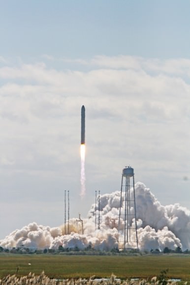
Antares rocket lifts off at 10:58 a.m. EDT Sept 18 with commercial Cygnus cargo resupply ship bound for the International Space Station (ISS) from Mid-Atlantic Regional Spaceport Pad-0A at NASA’s Wallops Flight Facility in Virginia.  Credit: Ken Kremer (kenkremer.com)
Antares rocket lifts off at 10:58 a.m. EDT Sept 18 with commercial Cygnus cargo resupply ship bound for the International Space Station (ISS) from Mid-Atlantic Regional Spaceport Pad-0A at NASA’s Wallops Flight Facility in Virginia. Credit: Ken Kremer (kenkremer.com)
Antares and Cygnus streak to space and the ISS from NASA Wallops on Sept. 18, 2013.  Credit: Ken Kremer (kenkremer.com)
Antares and Cygnus streak to space and the ISS from NASA Wallops on Sept. 18, 2013. Credit: Ken Kremer (kenkremer.com)

Pakistan’s “Earthquake Island” Seen From Space

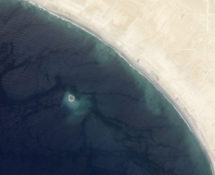
Mud island off the coast of Gwadar imaged by NASA's EO-1 satellite on Sept. 26, 2013

On the afternoon of Tuesday September 24, 2013, a 7.7-magnitude earthquake struck Balochistan province in southern Pakistan, causing widespread destruction across several districts during more than 2 minutes of powerful tremors and shaking. Sadly at least 400 people were killed (some reports say 600) and over 100,000 have been left homeless. But a weirder — if much less tragic — effect of the quake that was soon reported worldwide was the sudden appearance of a new island off the coast, a mound of mud and bubbling methane seeps rising nearly 20 meters (70 feet) from the ocean surface.

The image above, taken by NASA’s Earth Observing-1 satellite, shows the newly-formed mud island a kilometer (0.6 miles) off the Gwadar coast.

According to an article by the Pakistani news site Dawn.com, the 250-by-100-foot-long pile of mud and rocks is leaking flammable gases.

“Our team found bubbles rising from the surface of the island which caught fire when a match was lit and we forbade our team to start any flame,” said Mohammad Danish, a marine biologist from Pakistan’s National Institute of Oceanography. “It is methane gas.”

Aerial photo of the Gwadar mud volcano (National Institute of Oceanography, Pakistan)

Pakistan’s many earthquakes are the result of collisions between the Indian, Arabian, and Eurasian tectonic plates. These sorts of mud volcanoes are not particularly unusual after large quakes there… it just so happened that this one occurred near a populated coast and in relatively shallow water. (Source)

(In fact two days later another mud island was spotted off the coast of the nearby coastal town of Ormara.)

The mud volcano, which is being called “Zalzala Jazeera” (earthquake island) is not expected to last long. Wave action will eventually sweep the sediment away over the course of several months. (Dawn.com.)

Unfortunately earthquake relief efforts in the remote Taliban-dominated region are being hampered by militant activity.

Image source: NASA Earth Observatory