Space Debris: A Tale of Two Satellites

Artist's concept of a GOES spacecraft in orbit. (Credit: NOAA.gov).

It’s sometimes tough being a satellite in Earth orbit these days.

An interesting commentary came our way recently via NASA’s Orbital Debris Program Office’s Orbital Debris Quarterly News. The article, entitled High-Speed Particle Impacts Suspected in Two Spacecraft Anomalies, highlights a growing trend in the local space environment.

The tale begins with GOES 13 located in geostationary orbit over longitude 75° West. Launched on May 24th, 2006 atop a Delta IV rocket, GOES 13 is an integral part of the U.S. National Oceanic and Atmospheric Administration (NOAA’s) Geostationary Operational Environmental Satellite network.

The problems began when GOES-13 began to suffer an “attitude disturbance of unknown origin” on May 22nd of this year, causing it to drift about two degrees per hour off of its required nadir (the opposite of zenith) pointing.

The anomaly was similar to a problem encountered by the NOAA 17 spacecraft on November 20th, 2005. At the time, the anomaly was suspected to be due to a micrometeoroid impact. The Leonid meteors, which peak right around the middle of November, were a chief suspect. However, NOAA 17 suffered a second failure 18 days later, which was later traced down to a hydrazine leak from its errant thrusters.

GOES-13 has weathered hard times before.  Back in December of 2006, GOES-13’s Solar X-Ray Imager suffered damage after being struck by a solar flare shortly after initial deployment.   GOES-13 also began returning degraded imagery in September 2012, forcing it into backup status for Hurricane Sandy.

GOES-13 was restored to functionality last month. Current thinking is that the satellite was struck by a micrometeorite. No major meteor showers were active at the time.

Loss of a GOES satellite would place a definite strain on our weather monitoring and Earth observing capability. Begun with the launch of GOES-1 in 1975, currently six GOES satellites are in operation, including one used to relay data for PeaceSat (GOES-7) and one used as a communications relay for the South Pole research station (GOES-3).

The GOES program cost NOAA billions in cost overruns to execute. The next GOES launch is GOES-R scheduled in 2015.

But the universe seems to love coincidences.
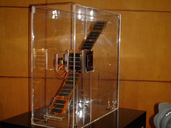
NEE-01 Pegaso before deployment. (Credit:
NEE-01 Pegaso before deployment. (Credit: Wikimedia Commons image in the Public Domain).

Less than 26 hours after the GOES 13 anomaly, Ecuador’s first satellite, NEE-01 Pegaso began to have difficulties keeping a stable attitude. The event happened shortly after passage near an old Soviet rocket booster (NORAD designation 1986-058B) which launched Kosmos 1768 on August 2nd, 1986. The U.S. Joint Space Operations Center had warned the fledgling Ecuadorian Space Agency that conjunction was imminent, but of course, there’s not much that could’ve been done to save the tiny CubeSat.

Although the main mass passed Pegaso at a safe distance, current thinking is that the discarded booster may have left a cloud of debris in its wake. Researchers have tracked small “debris clouds” around objects it orbit before- the collision of Iridium 33 and the defunct Kosmos 2251 on February 10th, 2009 left a ring of debris in its wake, and the Chinese anti-satellite test carried out on January 11th, 2007 showered low-Earth orbit with debris for years to come.

The loss represents a blow to Ecuador and their first bid to become a space-faring nation. Launched less than a month prior atop a Long March 2D rocket, Pegaso was a small 10 centimetre nanosatellite equipped with solar panels and dual infrared and visible Earth imaging systems.

A translation from the Ecuadorian Space Agencies site states that;

 “The NEE-01 survived the crash and remains in orbit; however it has entered uncontrolled rotation due to the event.

 Due to this rotation, (the satellite) cannot point its antenna correctly and stably to the Earth station and although still transmitting and running, the signal cannot be decoded. The Ecuadorian Civilian Space Agency is working tirelessly to stabilize the NEE-01 and recover the use of their signal.

The PEGASUS aired for 7 days your signal to the world via EarthCam, millions could see the Earth seen from space in real time, many for the first time, the files in those 7 days have been published after transmission.”

Ecuador plans to launch another CubeSat, NEE 02 Krysaor later in 2013. A carrier has not yet been named.

While both events suffered by the GOES-13 and NEE-01 Pegaso satellites were unrelated, they underscore problems with space junk and space environmental hazards that are occurring with a higher frequency.

Gabbard diagram displaying a sample disintegration of a Long March 4 booster in 2000. (Credit: the NASA Orbital Debris Office).

Such is the modern hazardous environment of low Earth orbit that new satellites must face. With a growing amount of debris, impact threats are becoming more common. The International Space Station must perform frequent debris avoidance maneuvers to avoid hazards, and more than once, the crew has waited out a pass in their Soyuz escape modules should immediate evacuation become necessary.  Punctures from micro-meteoroids or space junk have even been seen recently on the ISS solar panel arrays.

Plans are on the drawing board to deal with space junk, involving everything from “space nets” to lasers and even more exotic ideas. Probably the most immediate solution that can be implemented is to assure new payloads have a way to “self-terminate” via de-orbit at the end of their life span.  Solar sail technologies, such as NanoSailD2 launched in 2010 have already demonstrated this capability.

Expect reentries also pick up as we approach the peak of solar cycle #24 at the end of 2013 and the beginning of 2014. Increased solar activity energizes the upper atmosphere and creates increased drag on low Earth satellites.

It’s a brave new world “up there,” and hazards, both natural and man-made, are something that space faring nations will have to come to terms with.

-Read and subscribe to the latest edition of NASA’s Orbital Debris Quarterly News for free here.


A Heat Wave So Big You Can See It From Space

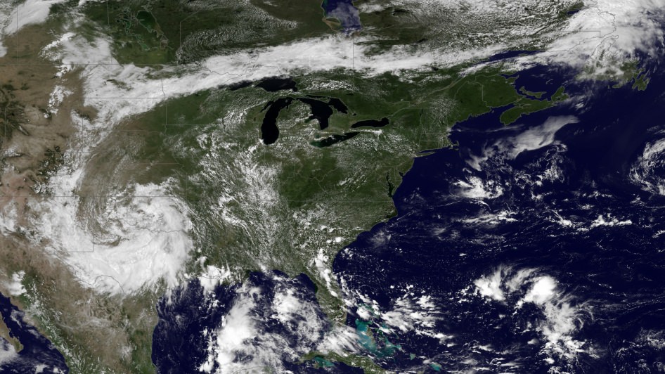
Image taken by NOAA's GOES East satellite at 12:45 p.m. EDT on July 15, 2013. (NOAA/NASA GOES Project)

Hot enough for ya? If you live anywhere on the eastern half of the United States (like me) you’ve probably been sweating it out over the past several days in what certainly feels like the warmest week yet for the season. The cause of the oppressive weather? A large mid-level ridge centered over the Ohio Valley — large enough to be easily visible from space.

The image above was taken by the GOES East satellite at 12:45 p.m. EDT on July 15. The clear area over Ohio shows the center of the system, which has been driving temperatures up into the 90s for much of the eastern U.S. and is expected to expand into the plains by mid-week. Along with increased humidity, heat index values will exceed 100 ºF and even approach 110 ºF on Friday.

From the NASA Image of the Day page:

A very anomalous weather pattern is in place over the U.S. for mid-July. Trapped between an upper level ridge centered over the Ohio Valley and the closed upper level low over the Texas/Oklahoma border, atypical hot, muggy air is stifling a broad swath of the eastern U.S. The closed low is expected to drift west toward New Mexico bringing heavy, localized rain to some areas and temperatures running 10-20 degrees below mid-July averages. Across the east, temperatures will warm well into the 90s and stay there through the week. (NOAA)

Rendering of a GOES satellite (NOAA)

As of the time of this writing heat advisories are in place in many parts of Michigan, southern Minnesota, and southern New England, and excessive heat warnings are active in eastern Pennsylvania and west central New Jersey. (Source)

Click here for summer heat safety tips.

Meanwhile, a closed low — seen above as a large, moisture-laden spiraling cloud system — is moving west across Texas and New Mexico, and is expected to bring lower-than-average temperatures along with heavy rains and flash flooding.

Keep up to date with weather alerts for your area at the NOAA’s National Weather Service site here, and see the latest GOES satellite images here.

Image Credit: NOAA/NASA GOES Project

At an altitude of 22,336 miles, the geosynchronous GOES satellites continuously provide observations of 60 percent of the Earth including the continental United States, providing weather monitoring and forecast operations as well as a continuous and reliable stream of environmental information and severe weather warnings.

NASA’s Independence Day Fireworks from Wallops Investigates Earth’s Global Daytime Dynamo Current

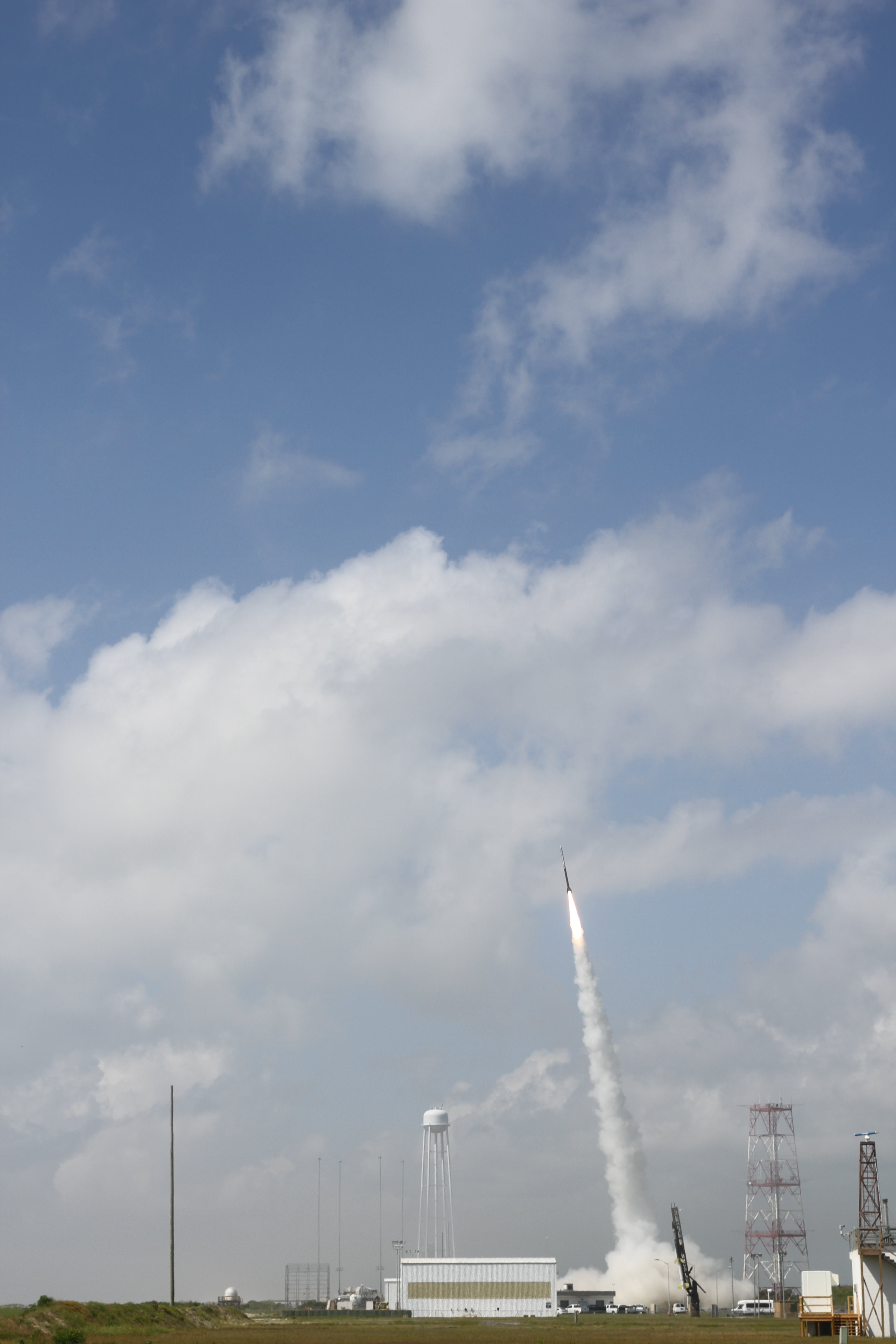
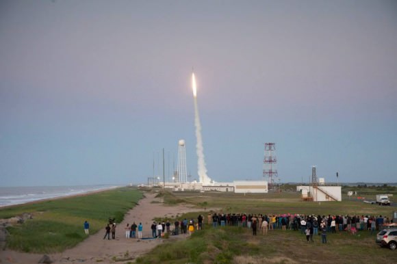
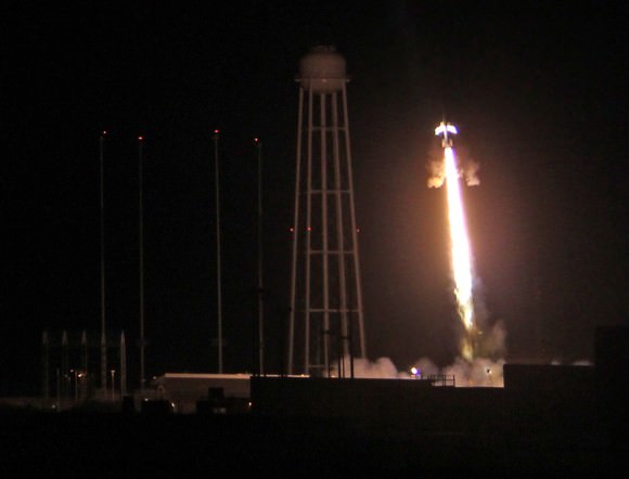
July 4 Morning Fireworks from NASA. A NASA Black Brant V Sounding Rocket launches in support of the Daytime Dynamo Mission on July 4, 2013 from NASA Wallops Flight Facility, VA, Credit NASA/J. Eggers

July 4 Morning Fireworks from NASA!
A NASA Black Brant V Sounding Rocket launches in support of the Daytime Dynamo Mission on July 4, 2013 from NASA Wallops Flight Facility, VA. Credit: NASA/J. Eggers[/caption]

WALLOPS ISLAND, VA – Today, July 4, NASA celebrated America’s Independence Day with a spectacular fireworks display of a dynamic duo of sounding rockets – blasting off barely 15 seconds apart this morning from the agencies NASA Wallops Island facility on the Eastern Shore of Virginia on a science experiment to study the ionosphere.

The goal of the two rocket salvo was an in depth investigation of the electrical currents in Earth’s ionosphere – called the Daytime Dynamo.

The Dynamo electrical current sweeps through the ionosphere, a layer of charged particles that extends from about 30 to 600 miles above Earth.

Disruptions in the ionosphere can scramble radio wave signals for critical communications and navigations transmissions that can impact our every day lives.

The launches suffered multiple delays over the past 2 weeks due to weather, winds, errant boats and unacceptable science conditions in the upper atmosphere.

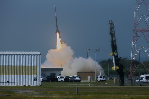
A Black Brant V launches first in support of Daytime Dynamo. Terroer improved Orion (at right) followed 15 seconds later from NASA Wallops on July 4, 2013. Credit:  NASA/P. Black
A Black Brant V launches first in support of Daytime Dynamo. Terroer improved Orion (at right) followed 15 seconds later from NASA Wallops on July 4, 2013. Credit: NASA/P. Black

At last, the Fourth of July was the irresistible charm.

The liftoff times were 10:31:25 a.m. for the Black Brant V and 10:31:40 a.m. (EDT) for the Terrier-Improved Orion.

The experiment involved launching two suborbital rockets and also dispatching a NASA King Air airplane to collect a stream of airborne science measurements.

Daytime Dynamo is a joint project between NASA and the Japanese Space Agency, or Japan Aerospace Exploration Agency, or JAXA, said Robert Pfaff to Universe Today in an exclusive interview inside Mission Control at Wallops. Pfaff is the principle investigator for the Dynamo sounding rocket at NASA’s Goddard Space Flight Center in Greenbelt, Md.

“The dynamo changes during the day and varies with the season,” Pfaff told me.

But they only have one chance to launch. So the science team has to pick the best time to meet the science objectives.

“We would launch every month if we could and had the funding, in order to even more fully characterize the Dynamo.”

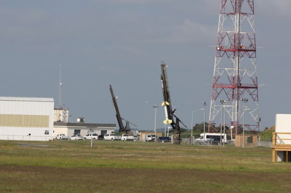
Two rocket salvo comprising a Black Brant V (left) and a Terrier-Improved Orion (right) sit ready to launch as part of the Daytime Dynamo mission in this panoramic view from NASA Wallops Flight Facility at Virginia’s Eastern Shore.  Credit:  Ken Kremer
Two rocket salvo comprising a Black Brant V (left) and a Terrier-Improved Orion (right) sit ready to launch as part of the Daytime Dynamo mission in this panoramic view from NASA Wallops Flight Facility at Virginia’s Eastern Shore. Credit: Ken Kremer/kenkremer.com

The 35 foot tall single-stage Black Brant V launched first. It carried a 600 pound payload to collect the baseline data to characterize the neutral and charged ionospheric particles as it blasted skyward.

The 33 foot tall two-stage Terrier-Improved Orion took off just 15 seconds later in the wake of the exhaust of the Black Brant V.

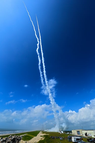
Exhaust trails from Black Brant V and a Terrier-Improved Orion launched in support of Daytime Dynamo mission on July 4, 2013. Credit: NASA P. Black
Exhaust trails from Black Brant V and a Terrier-Improved Orion launched in support of Daytime Dynamo mission on July 4, 2013. Credit: NASA/P. Black

The Terrier-Improved Orion successfully deployed a lengthy trail of lithium gas from a pressurized canister that created a chemical tracer to track how the upper atmospheric winds vary with altitude. These winds are believed to be the drivers of the dynamo currents.

Both rockets fly for about five minutes to an altitude of some 100 miles up in the ionosphere. They both splashed down in the ocean after about 15 minutes.

NASA’s King Air aircraft was essential to the mission. I toured the airplane on the Wallops runway for an up-close look inside. It is outfitted with a bank of precisely aimed analytical instruments peering through the aircraft windows to capture the critical science data – see my photos herein.

“The King Air launches about an hour before the scheduled liftoff time,” Pfaff told me.

“It uses special cameras and filters to collect visible and infrared spectroscopic data from the lithium tracer to characterize the daytime dynamo.”

The science instruments are newly developed technology to make the daytime measurements of the lithium tracer and were jointly created by NASA, JAXA and scientists at Clemson University.

“Everything worked as planned,” Pfaff announced from Wallops Mission Control soon after the magnificent Fourth of July fireworks show this morning.

Ken Kremer

Black Brant V (left) and a Terrier-Improved Orion (right) rockets sit on launch pads as part of the Daytime Dynamo mission in this up close  view from NASA Wallops Flight Facility at Virginia’s Eastern Shore.  Credit: Ken Kremer/kenkremer.com
Black Brant V (left) and Terrier-Improved Orion (right) rockets sit on launch pads as part of the Daytime Dynamo mission in this up close view from NASA Wallops Flight Facility at Virginia’s Eastern Shore. Credit: Ken Kremer/kenkremer.com
Inside cabin view of NASA King Air aircraft outfitted with science instrument mounts to support a of cameras to capture visible and infrared spectroscopic measurements in support of Daytime Dynamic launches on July 4, 2013.  Credit: Ken Kremer/kenkremer.com
Inside cabin view of NASA King Air aircraft outfitted with science instrument mounts to support a bank of cameras to capture visible and infrared spectroscopic measurements in support of Daytime Dynamic launches on July 4, 2013. Credit: Ken Kremer/kenkremer.com
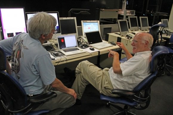
Robert Pfaff (right), Science Principle Investigator and Ken Kremer of Universe Today (left) discuss NASA’s Daytime Dynamo mission inside NASA Wallop’s Mission Control.  Credit: Ken Kremer/kenkremer.com
Robert Pfaff (right), Science Principle Investigator and Ken Kremer of Universe Today (left) discuss NASA’s Daytime Dynamo mission inside NASA Wallop’s Mission Control. Credit: Ken Kremer/kenkremer.com

NASA’s Daytime Dynamo Experiment Deploys Lithium to Study Global Ionospheric Communications Disruptions

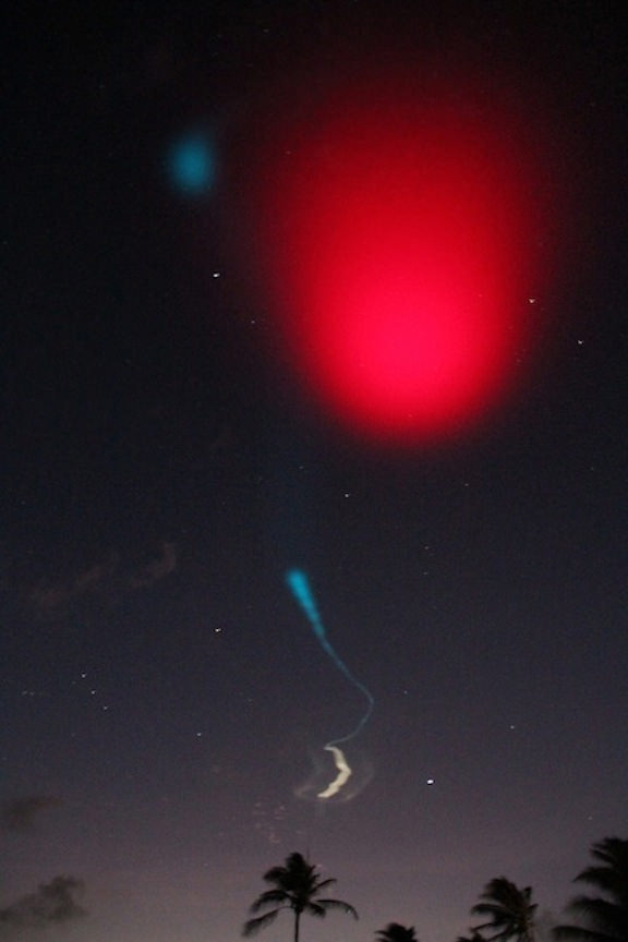
On June 24, 2013 a pair of daytime sounding rockets will launch from NASA Wallops Flight Facility (WFF) and deploy a chemical trail like the one deployed here from a sounding rocket at night. The chemical trail will help researchers track wind movement to determine how it affects the movement of charged particles in the atmosphere. All the colors in the sky shown here, the white and blue streaks, and the larger red blob overhead, are from the chemical trails. Credit: NASA

On June 24, 2013 a pair of daytime sounding rockets will launch from NASA Wallops Flight Facility (WFF) and deploy a chemical trail like the one deployed here from a sounding rocket at night. The chemical trail will help researchers track wind movement to determine how it affects the movement of charged particles in the atmosphere. All the colors in the sky shown here, the white and blue streaks, and the larger red blob overhead, are from the chemical trails. Credit: NASA
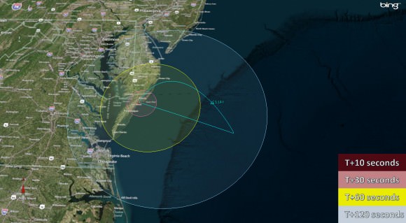
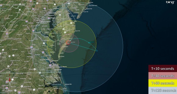
See Rocket Visibility Maps below[/caption]

NASA WALLOPS, VA – Science and space aficionados are in for rare treat on June 24 when NASA launches a two-rocket salvo from the NASA Wallops Flight Facility, Va. on a mission to study how charged particles in the ionosphere can disrupt communication signals that impact our day to day lives.

It’s a joint project between NASA and the Japanese Space Agency, or Japan Aerospace Exploration Agency, or JAXA.

The suborbital sounding rockets will blast off merely 15 seconds apart from a beach-side launch complex directly on Virginia’s Eastern shore on a science mission named the Daytime Dynamo.

An electric current called the dynamo, illustrated here, sweeps through Earth’s upper atmosphere. A sounding rocket called Dynamo will launch in the summer of 2013 to study the current, which can disrupt Earth’s communication and navigation signals. Credit: USGS
An electric current called the dynamo, illustrated here, sweeps through Earth’s upper atmosphere.A pair of sounding rockets called Dynamo will launch on June 24, to study the current, which can disrupt Earth’s communication and navigation signals. Credit: USGS
Lithium gas will be deployed from one of the rockets to create a chemical trail that can be used to track upper atmospheric winds that drive the dynamo currents.

The goal is to study the global electrical current called the dynamo, which sweeps through the ionosphere, a layer of charged particles that extends from about 30 to 600 miles above Earth.

Why should you care?

Because disruptions in the ionosphere can scramble radio wave signals for communications and navigations transmissions from senders to receivers – and that can impact our every day lives.

The experiment involves launching a duo of suborbital rockets and also dispatching an airplane to collect airborne science measurements.

Mission control and the science team will have their hands full coordinating the near simultaneous liftoffs of two different rockets with two different payloads while watching the weather to make sure its optimal to collect the right kind of data that will answer the research proposal.

A single-stage Black Brant V will launch first. The 35 foot long rocket will carry a 600 pound payload to collect the baseline data to characterize the neutral and charged particles as it swiftly travels through the ionosphere.

Visibility map for Black Brant V rocket launch on June 24 at 9:30 a.m.  Credit: NASA Wallops
Visibility map for Black Brant V rocket launch on June 24 at 9:30 a.m. Credit: NASA Wallops

A two-stage Terrier-Improved Orion blasts off just 15 seconds later. The 33 foot long rocket carries a canister of lithium gas. It will shoot out a long trail of lithium gas that creates a chemical trail that will be tracked to determine how the upper atmospheric wind varies with altitude. These winds are believed to be the drivers of the dynamo currents.

Visibility map for Terrier-Improved Orion rocket launch on June 24 at 9:30 a.m.  Credit: NASA Wallops
Visibility map for Terrier-Improved Orion rocket launch on June 24 at 9:30 a.m. Credit: NASA Wallops

Both rockets will fly for about five minutes to an altitude of some 100 miles up in the ionosphere.

Since its daytime the lithium trails will be very hard to discern with the naked eye. That’s why NASA is also using a uniquely equipped NASA King Air airplane outfitted with cameras with special new filters optimized to detect the lithium gas and how it is moved by the winds that generate the global electrical current.

The new technology to make the daytime measurements was jointly developed by NASA, JAXA and scientists at Clemson University.

RockOn 2013 University student payload blasts off on June 20,2013 atop a NASA Terrier-Improved Orion suborbital rocket from NASA Wallops at Virginia’s eastern shore. Credit: NASA/Chris Perry

Sounding rockets are better suited to conduct these studies of the ionosphere compared to orbiting satellites which fly to high.

“The manner in which neutral and ionized gases interact is a fundamental part of nature,” said Robert Pfaff, the principle investigator for the Dynamo sounding rocket at NASA’s Goddard Space Flight Center in Greenbelt, Md.

“There could very well be a dynamo on other planets. Jupiter, Saturn, Uranus and Neptune are all huge planets with huge atmospheres and huge magnetic fields. They could be setting up dynamo currents galore.”

The launch window opens at 9:30 a.m. and extends until 11:30 a.m. Back up opportunities are available on June 25 and from June 28 to July 8.

The rockets will be visible to residents in the Wallops region – and also beyond to the US East Coast from parts of North Carolina to New Jersey.

The NASA Wallops Visitor Center will open at 8 a.m. on launch day for viewing the launches.

Live coverage of the June 24 launch is available via NASA Wallops UStream beginning at 8:30 a.m. at: http://www.ustream.tv/channel/nasa-tv-wallops

I will be onsite at Wallops for Universe Today.

And don’t forget to “Send Your Name to Mars” aboard NASA’s MAVEN orbiter- details here. Deadline: July 1, 2013. Launch: Nov. 18, 2013

Ken Kremer

…………….
Learn more about Earth, Mars, Curiosity, Opportunity, MAVEN, LADEE, Sounding rockets and NASA missions at Ken’s upcoming presentation

June 23: “Send your Name to Mars on MAVEN” and “CIBER Astro Sat, LADEE Lunar & Antares Rocket Launches from Virginia”; Rodeway Inn, Chincoteague, VA, 8 PM

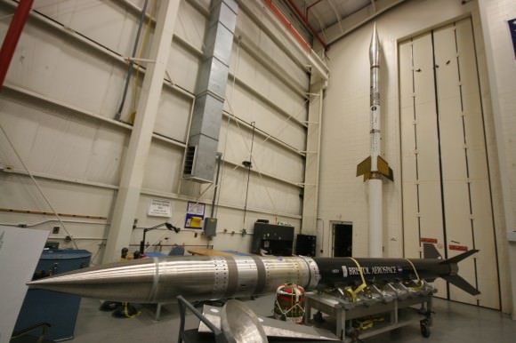
Show here are the two types of sounding rockets that will launch on June 24, 2013 from NASA Wallops Island, VA., on the Daytime Dynamo mission. Black Brant V rocket is horizontal. Terrier-Improved Orion rocket is vertical. Credit: Ken Kremer
Show here are the two types of sounding rockets that will launch on June 24, 2013 from NASA Wallops Island, VA., on the Daytime Dynamo mission. Black Brant V rocket is horizontal. Terrier-Improved Orion rocket is vertical. Credit: Ken Kremer – kenkremer.com
Night time launch of NASA Black Brant XII suborbital rocket at 11:05 p.m. EDT on June 5, 2013 from the NASA Wallops Flight Facility carrying the CIBER astronomy payload. Credit: Ken Kremer- kenkremer.com

Is This What a Mars Outpost Will Look Like from Orbit?

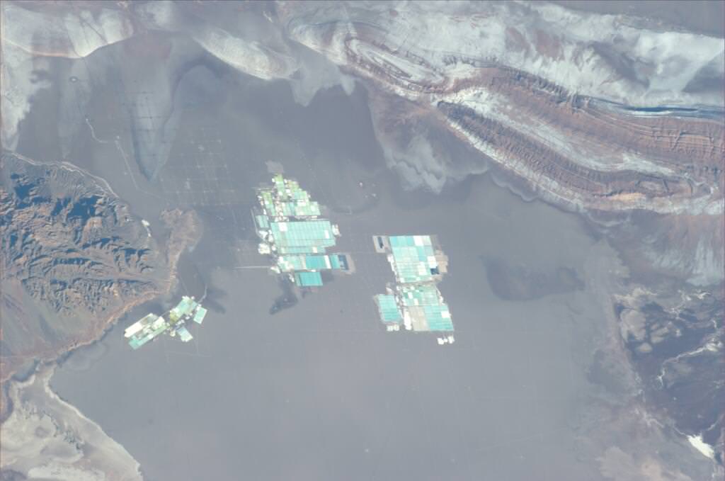
Image taken by Italian astronaut Luca Parmitano from the International Space Station, who said, 'Maybe one day our settlements on Mars will look like this." Credit: NASA/ASI

This sure looks like a futuristic settlement on the Red Planet, as Italian astronaut Luca Parmitano pondered on Twitter yesterday when he shared this image taken from the International Space Station, saying, “Maybe one day our settlements on Mars will look like this.”

But what is this facility — which must be huge and looks to be out in the middle of absolutely nowhere? A secret new branch at Area 51? A mock-up of a base from the “Legion of Space” sci-fi books?

It’s actually one of the world’s largest lithium salt production facilities, located in the “lithium triangle” of Argentina, Chile and Bolivia, high in the Atacama desert in Chile. Below is an aerial view:

An aerial view of the brine pools and processing areas of the Soquimich lithium mine on the Atacama salt flat, the largest lithium deposit currently in production, in the Atacama desert of northern Chile, on Jan. 10, 2013. Credit: Ivan Alvarado / Reuters.

You can read a great article here (with more great images) about the lithium mining operations, enabling all your electronic gizmos to be powered.

How Can You See a Satellite View of Your House?

How to See Your House From Space

This is an article from our archive, but we’ve updated it with this spiffy video.

Every now and then I go looking for a free aerial view of my home. It’s amazing what’s available through the internet now, totally free. Thanks to commercial Earth observation satellites, and internet tools that make these photos accessible through the internet, it’s easy to see your house from space.

In our modern space age, there are more than 8,000 satellites currently orbiting the Earth. The vast majority of these are relaying data to and from the Earth, and many are equipped with high power cameras. Just look up into the sky any night, and you’re sure to see satellite after satellite passing overhead. But what are some ways you can get access to these satellite and aerial images of your house?

Western Hemisphere of Earth

Satellite Images of the Whole Earth
If you want to go way out and just see a satellite image of the entire planet, there are some solutions for you: weather satellites. For example, NOAA’s Geostationary Operational Environmental Satellites (GOES) release images of an entire hemisphere of planet Earth every 3 hours. From these images you can see major weather patterns affecting parts of the Earth. But you really can’t see any specific spot on Earth with any detail.

What is really cool about these satellite views is that they’re live. The weather systems you’re seeing in those images are happening on the planet right now.

If you don’t want a live view, and really just want to see a beautiful view of the Earth’s hemisphere, check out these images produced by NASA. Here’s a composite photograph that shows the Earth’s Western Hemisphere, and here’s a view of the Earth’s Eastern Hemisphere.

There were also some amazing new satellite images of the Earth released from the European Space Agency’s 3rd generation Meteosat spacecraft.

Zoom in. Let’s see Satellite Pictures of Houses
If those whole Earth pictures don’t give you enough detail, let’s zoom in, and see some pictures of houses from space. The best tool on the market, in my opinion, is the service from Google Maps. All you need is a web browser and a connection to the internet. When you first start up, Google Maps displays a satellite view of North America. You can then zoom in, or pan the camera around to see any location on Earth. You can also type in the address of the location that you want to see. Once you do that, you’ll get a free satellite view of your house. You can save the image or print it off.


View Larger Map

Another cool tool from Google is Google Earth. You can access by going to http://earth.google.com. The main difference between Google Maps and Google Earth is that you have to download and install Earth on your local computer (they have a version for PCs, Mac, Linux, and even the iPhone). Once you’ve downloaded and installed Google Earth, you can see a 3-dimensional view of Earth that you can zoom in and out and spin around. You can type in your address and get a view of your house from above. I actually like the printing function of Google Earth better, since it’s using your printer directly, and not going through the web browser.

And if you really hate using products from Google, no problem. There are similar services from Yahoo and Microsoft. Microsoft’s mapping service used to be called MSN Maps, and now it’s been changed to Bing Maps with their new identity. The Yahoo service is called Yahoo Maps, and it’s very similar to Google Maps. The two services do have some big differences, though, and there’s a cool application that lets you see the two of them side-by-side. I used it for my home and found that Google Maps has better resolution maps for my city.


Where Do All these Pictures Come From?
Google Maps and the other internet mapping services are really just customers for the satellite services that actually take these photographs from space. There are a few major services on the market, including GeoEye. GeoEye’s main competitors include DigitalGlobe and Spot Image.

Each company has a fleet of Earth observation satellites, with a capability of resolving features on the surface of the Earth as small as about 45 cm (18 inches). In other words, an object 45 centimeters across would appear as a single pixel in their photographs.

Private earth observation satellites:

  • GeoEye – 5 satellites: IKONOS, OrbView-2, OrbView-3, GeoEye-1, GeoEye-2 (in 2013).
  • DigitalGlobe – 4 satellites: Early Bird 1, Quickbird, WorldView-1, Worldview-2
  • Spot Image – 2 satellites: Spot 4, Spot 5

Each of these services allow customers to purchase satellite imagery directly, but I’ll warn you, the prices are extremely high: hundreds or even thousands of dollars for satellite imagery. You typically can’t buy directly from the satellite company itself, but through their international partners.It’s better to stick to the free sources.

Are These Live Satellite Views?
When you look at these amazing views of your house from space, you might wonder if this is live. If you walk outside and look up, will you be able to see yourself from space? Unfortunately, no. All of the free satellite images you’re accessing were captured by various spacecraft over the last couple of years.

You can actually get a pretty good sense of when the picture was taken by the image of your property. For example, in the photo of my house from space, I can see a car that I sold a couple of years ago. Obviously, this image isn’t live, it’s at least a couple of years old – even a decade old in some cases. A live satellite view of your house, is still a few years off.

There are some services which will give you a live view of Earth from space. For example, you can access a live broadcast from NASA’s International Space Station. About 40% of the time, if you follow this link you can see a live view of Earth from the space station. Another service called Urthecast will be attaching a high definition camera to the International Space Station in 2013 to broadcast a live view of Earth from space.


Streaming video by Ustream

Swath of Destruction from Deadly Oklahoma Tornado Visible from Space

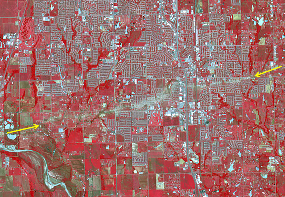
The track of the tornado that struck Moore, Oklahoma on May 20, 2013 is visible from space in this false color image taken on June 2, 2013 by the Advanced Spaceborne Thermal Emission and Reflection Radiometer (ASTER) on NASA’s Terra satellite.

The tornado that devastated the region around Moore and Newcastle, Oklahoma on May 20, 2013 has been determined to be an EF-5 tornado, the most severe on the enhanced Fujita scale, and has been called one of the most powerful and destructive tornadoes ever recorded. In this new image taken by the Advanced Spaceborne Thermal Emission and Reflection Radiometer (ASTER) on NASA’s Terra satellite, the scar of destruction on the Oklahoma landscape is clearly visible from space. In this false-color infrared image, red highlights vegetation, and the tornado track appears as a beige strip running west to east across this image; the color reveals the lack of vegetation in the wake of the storm.

According to the National Weather Service, the tornado was on the ground for 39 minutes, ripping across 17 miles (27 kilometers) from 4.4 miles west of Newcastle to 4.8 miles east of Moore. At its peak, the funnel cloud was 1.3 miles (2.1 kilometers) wide and wind speeds reached 210 miles (340 km) per hour. The storm killed at least 24 people, injured 377, and affected nearly 33,000 in some way.

In this image, infrared, red, and green wavelengths of light have been combined to better distinguish between water, vegetation, bare ground, and human developments. Water is blue. Buildings and paved surfaces are blue-gray.

You can also see an interactive satellite map from Google and Digital Globe, showing detail of every building that was damaged or destroyed. Satellite data like this are helping to assist in the recovery and rebuilding of the area. Satellite imagery can provide a systematic approach to aiding, monitoring and evaluating the process.

Source: NASA Earth Observatory

Stunning View of Earth and Orbital Sunset from the Space Station

An orbital sunset puts Earth in a unique light, as seen from the International Space Station. Credit: NASA, via astronaut Karen Nyberg.

This is just a gorgeous shot of our home planet from the International Space Station, shared by astronaut Karen Nyberg via Twitter. While many pictures of Earth from space show a bright view of our planet, this view of the world plunging into darkness provides a unique, not-often-seen view. If a picture can be this beautiful, imagine what must look like in person.

Nyberg is sharing her experiences via Twitter and also — I believe she is the first astronaut sharing on Pinterest. She describes herself as “Aspiring quilter, crafter, artist” (perfect for the Pinterest crowd) in addition to being an astronaut by day, and said she hopes to do some crafting in space if she has any spare time. Nyberg has a special board for “Hair in Space” (which includes both bald pates and gravity defying hair,) hoping to inspire the younger generation of women to get interested in space exploration. “When girls see pictures of ponytails, don’t you think it stirs something inside them that says, that could be ME up there!” Nyberg writes.

Here’s How You Can Download The Earth In High-Resolution

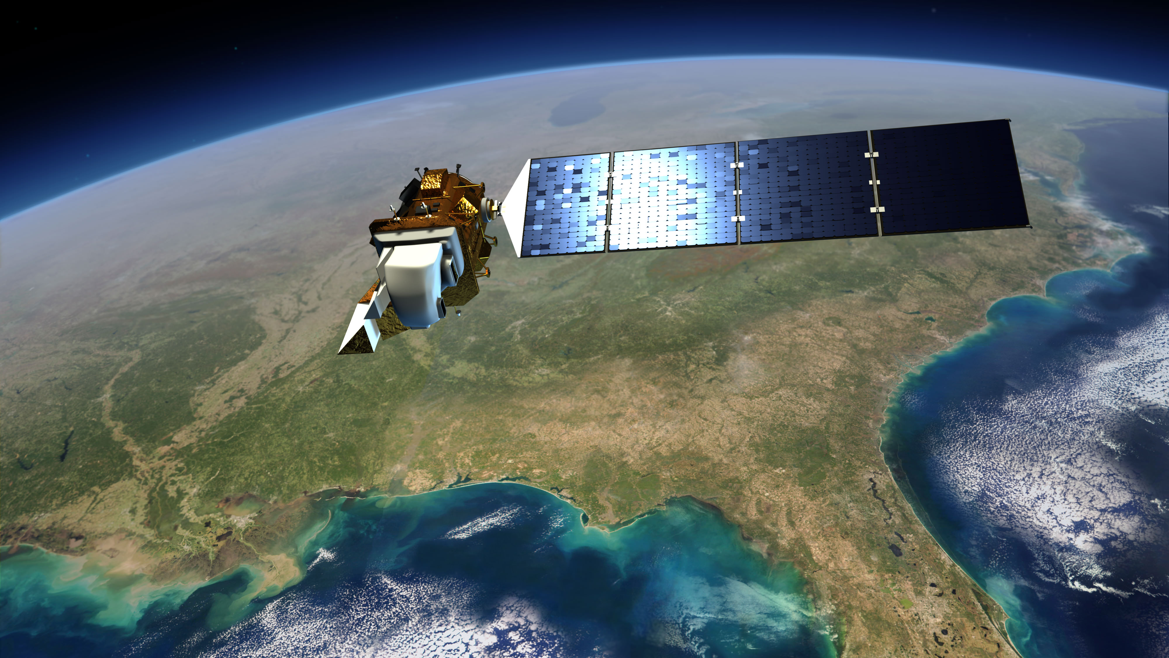
Artist's conception of Landsat 8 (renamed from Landsat Data Continuity Mission). Credit: NASA/ Goddard/Conceptual Image Lab

Landsat 8 officially opened its eyes to Earth yesterday (May 30). Officials are promising the clearest views yet of the four-decade-old Landsat program, and luckily for people who love amazing Earth views, the images Landsat produces are free.

Before talking a bit about Landsat 8, here’s one way you can find the images: go to this website of raw Landsat data from the United States Geological Survey. In the menu tab “Collection”, go down to “Landsat Archive” and select “Landsat 8 OLI.” Then click a location on the map to see if it’s taken a picture of a spot you’re interested in.

Once you’ve selected it, hit “Add Scene”, then click on the scene list at the bottom right of the screen to download the product. (We’d strongly advise consulting the tutorial on that website for more help. You need to register as a user to download the high-resolution images.)

There isn’t much to see there yet, but over the next few months there should be a wealth of pictures to choose from. More spots where Landsat 8 data will appear are listed on this USGS page.

You may better recall Landsat 8 as the Landsat Data Continuity Mission. Launched on Feb. 11, it was first under the operational control of NASA as the agency put the satellite through its paces — placing it into the proper orbit (it circles in a near-polar orbit) and taking some test images of the planet, for example.

Now that the satellite is ready, the USGS has operational control and will add that to more than 40 years of data collected under the Landsat program. The aim, we assure you, is not just for pretty pictures.

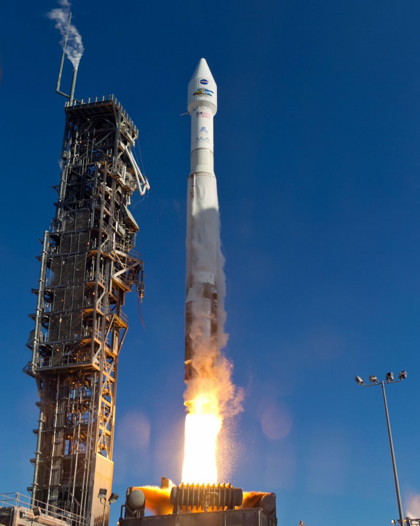
An  Atlas-V rocket with the Landsat Data Continuity Mission (LDCM) spacecraft onboard is seen as it launches on Monday, Feb. 11, 2013 at Vandenberg Air Force Base, California. Credit: NASA
An Atlas-V rocket with the Landsat Data Continuity Mission (LDCM) spacecraft onboard is seen as it launches on Monday, Feb. 11, 2013 at Vandenberg Air Force Base, California. Credit: NASA

Long Earth observation programs show changes in the land over time. We can see cities grow, observe forests shrink or deserts expand in response to human activity or climate change, and also gauge the impact of natural disasters. In the past, Landsat pictures have been used to map the impact of the Mount St. Helen’s eruption of 1980, and to respond to oil gas fires set in Kuwait during the Gulf War of 1991.

These are heavyweight satellites. The truck-sized Landsat 8 weighs 4,566 lbs (2,071 kg) fully loaded with fuel, excluding the weight of the instruments. Its operational land imager can take pictures in nine spectral bands, which is important because certain types of vegetation or land features show up better in different light spectra. (One application is to monitor the health of certain kind of plants in farmer fields, for example.) It also has two thermal infrared sensor bands that will show the heat signature of Earthly features.

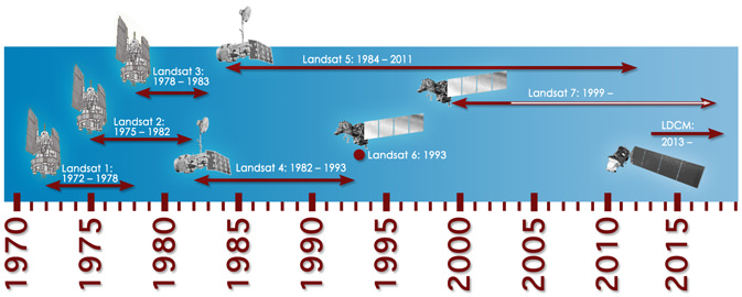
For Landsat, officials needed to launch this satellite because its predecessor (Landsat 7)’s operational lifetime is in overtime. Should the satellite have failed before Landsat 8 arrived, 41 years of continuous Earth observations under the same program would have ceased.

Landsat 8 will circle the globe 14 times daily, will repeat its ground track every 16 days, and is expected to do this for at least five years. Check out this USGS feature story for more on how it will contribute to Earth observation.

Timeline showing lifespans of the Landsat satellites. Credit: NASA

Astonishing Hi-Resolution Satellite Views of the Destruction from the Moore, Oklahoma Tornado

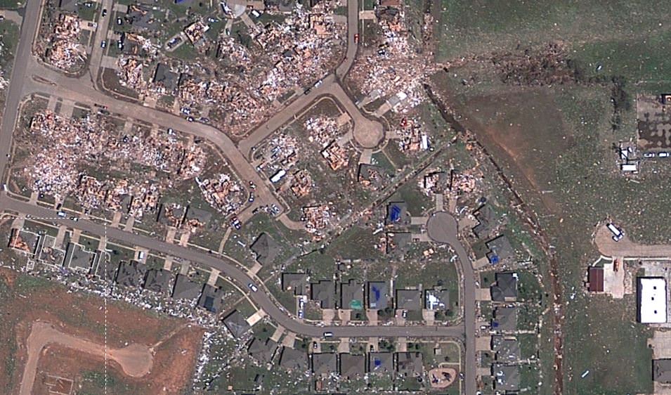
Sceenshot of a satellite view from Google/Digital Globe of the destruction in Moore, Oklahoma after the May 20, 2013 tornado. Click image to have access to an interactive, zoomable version via NPR.

A new satellite map from Google and Digital Globe shows just-released satellite imagery of the damage from the tornado that struck the area of Moore, Oklahoma on May 20, 2013. It’s been called one of the most powerful and destructive tornadoes ever recorded — determined to be an EF5 tornado, the strongest rating for a tornado — and the destruction is heartbreaking. In the screenshot above, you can see how some houses were left undamaged, while others were completely destroyed.

Click on the image above to have access to an interactive map that shows hi-resolution views of the damage, providing details of where the buildings and houses once were. NPR put this map together, using satellite data from Digital Globe, along with property data from City of Oklahoma City, City of Moore, and Cleveland County. Satellite data like this are helping to assist the recovery and rescue teams on the ground.

In the immediate aftermath of a natural catastrophe such as this tornado, the priority is searching for survivors and saving lives.

But longer term recovery — including the rebuilding of infrastructure and amenities such as schools and hospitals — can take decades, and satellite imagery can provide a systematic approach to aiding, monitoring and evaluating this process.

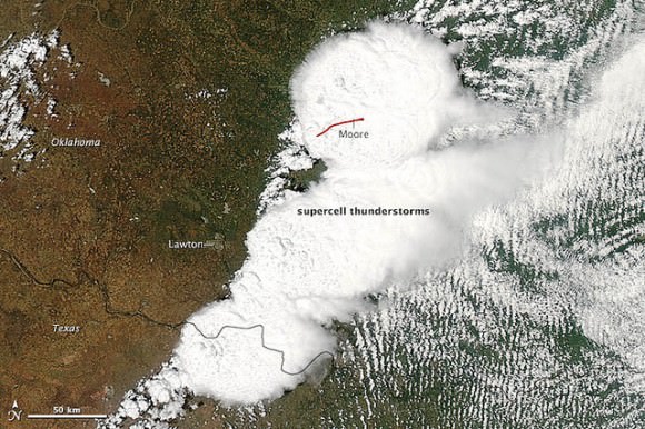
Satellite view of the destructive tornado that passed just south of Oklahoma City. The Moderate Resolution Imaging Spectroradiometer (MODIS) on NASA’s Aqua satellite acquired this image of the storm at 2:40 p.m. local time (19:40 UTC) on May 20, 2013. Credit: NASA image courtesy Jeff Schmaltz, LANCE/EOSDIS MODIS Rapid Response Team at NASA GSFC.

See more satellite views from NASA of the storm and aftermath on NASA Goddard’s Flickr page for this tornado.

The Take Part website has a list of organizations that are providing support for the recovery and care of the people affected, if you would like to contribute.