The Top 5 “Earth as Art” Images, Thanks to Landsat

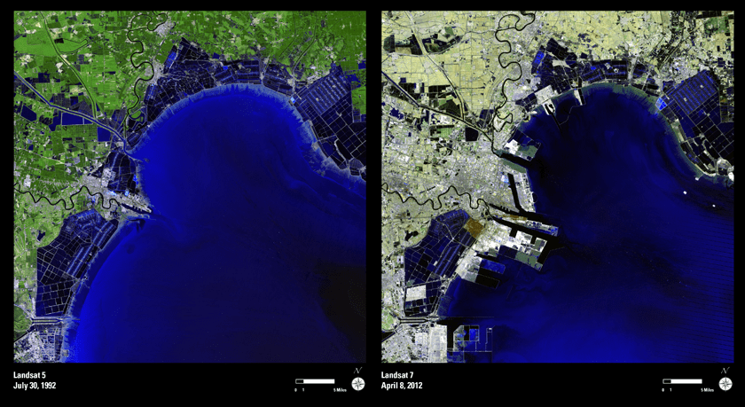
NASA’s first Earth-observing Landsat satellite launched from Vandenberg Air Force Base on July 23, 1972, and to celebrate the 40th anniversary of the program they asked the public to vote on their favorite images of the planet from the Landsat Earth as Art gallery. After over 14,000 votes, these were chosen as the top 5 favorites. Happy 40th anniversary, Landsat!

Landsat images from space are not merely pictures. They contain many layers of data collected at different points along the visible and invisible light spectrum. A single Landsat scene taken from 400 miles above Earth can accurately detail the condition of hundreds of thousands of acres of grassland, agricultural crops or forests.

“Landsat has given us a critical perspective on our planet over the long term and will continue to help us understand the big picture of Earth and its changes from space,” said NASA Administrator Charles Bolden. “With this view we are better prepared to take action on the ground and be better stewards of our home.”

In cooperation with the U.S. Geological Survey (USGS), a science agency of the Interior Department, NASA launched six of the seven Landsat satellites. The resulting archive of Earth observations forms a comprehensive record of human and natural land changes.
“The first 40 years of the Landsat program have delivered the most consistent and reliable record of Earth’s changing landscape.”

– Michael Freilich, director of NASA’s Earth Science Division

“Over four decades, data from the Landsat series of satellites have become a vital reference worldwide for advancing our understanding of the science of the land,” said Interior Department Secretary Ken Salazar. “The 40-year Landsat archive forms an indelible and objective register of America’s natural heritage and thus it has become part of this department’s legacy to the American people.”

The next satellite in the series, the Landsat Data Continuity Mission (LDCM) is scheduled to launch on February 11, 2013.

(Source: NASA/GSFC)

Find out more about the ongoing Landsat mission here, and see recent visualizations from Landsat on the USGS site here.

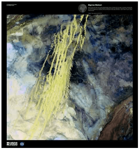
Video: NASA/GSFC. Inset image: Industrial growth in Binhai New Area, China.  Sub-feature: Erg Iguidi, an area of ever-shifting sand dunes extending from Algeria into Mauritania in northwestern Africa, one of the chosen top 5 Earth as Art images. NASA/GSFC/USGS.

Brazilian Band Soars to New Heights with a NASA-Inspired Video


Popular Brazilian rock band Fresno recently released a new video for their new song, “Infinito”, and it really rises above the rest — literally!

It’s a story of four guys who take their childhood dream of launching a package up into space and, after years apart, come back together to make it a reality. Along the way we get to see some great views from a camera that the band members actually sent up to the edge of space via weather balloon — an accomplishment that came with its fair share of challenges.

Fresno lead member Lucas Silveira shared some behind-the-scenes info with Universe Today. “We wasted two cameras. One of them landed on a military base — exactly in the middle of a mine field — and the other simply disappeared… completely lost due to the lack of cellular signal on the landing spot.”

And even on a successful third try there were some technical difficulties.

“In our third attempt we used a different balloon, with more capacity, and it managed to fly for over 3.5 hours… but our camera only survived for around 2.5 hours. So we had to send a smaller balloon just to capture the ‘popping up’ moment, and added it to the ‘main balloon ride’ on post production.”

Still, the results — a dizzying view of Earth from 35 km up — are well worth it, and the story is an inspiring one… inspired, in fact, by NASA.

“I wrote this song after watching a video by NASA in which they zoom out from the Himalayas to the edge of the universe, showing the areas that still yet to be mapped. We are so infinitely small in the middle of all this greatness, and suddenly our problems get as tiny in our heads as our lucky existence here. It’s about searching for better days, creating a better future through proactivity and not letting others letting you down.”

When you soar that high it’s hard to feel let down.

Video courtesy of Fresno. Technical and launch assistance provided by ACRUX Aerospace Technologies. Band photo by Gustavo Vara.

Wildfire Smoke is Visible Even at Night from Space

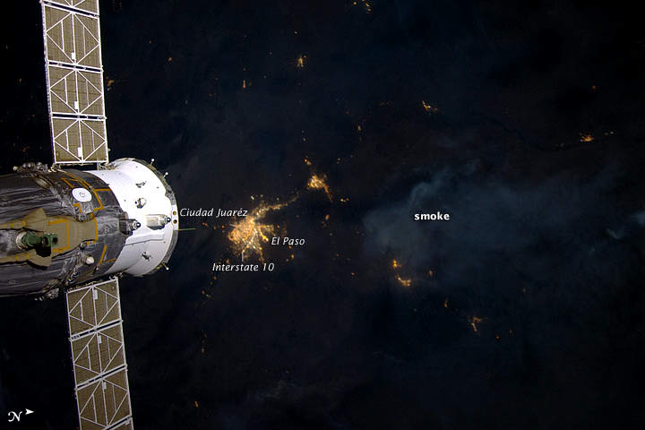
The Whitewater-Baldy fire is the largest wildfire in New Mexico’s history and has charred more than 465 square miles of the Gila National Forest since it started back on May 16, 2012 after several lightning strikes in the area. This wildfire produced so much smoke that it was visible even at night to the astronaut photographers on the International Space Station. This image was taken on June 2, 2012 by the crew of Expedition 31 on the ISS, with a Nikon D3S digital camera. A Russian spacecraft docked to the station is visible on the left side of the image.

Credit: NASA Earth Observatory website.

Powerful “Derecho” Storms as Seen from Space

The powerful windstorms that swept across the US last week was captured by several different satellites. This type of storm, called a derecho, moved from Illinois to the Mid-Atlantic states on June 29, and the movie from NOAA’s GOES-13 satellite shows the storms’ sudden expansion and speed. The storms left a more than 1,000-km (700-mile) trail of destruction across the Midwest and mid-Atlantic, cutting power to millions and killing thirteen people.

A derecho (pronounced “deh-REY-cho”) is not your average, ordinary local summer thunderstorm. These are widespread, long-lived but rare wind storms that are usually associated with a band of rapidly moving showers or thunderstorms. Damage from a derecho is usually in one direction along a relatively straight track. By definition an event is classified a derecho if the wind damage swath extends more than 400 km (240 miles) and includes wind gusts of at least 93 km/h (58 mph) or greater along most of its length.

These storms occur in the United States during the late spring and summer, with more than three quarters occurring between April and August.

The movie begins on June 28 at 15:15 UTC (11:15 a.m. EDT) and ends on June 30, 2012 at 16:01 UTC (12:01 p.m. EDT). In the animation, the derecho’s clouds appear as a line in the upper Midwest on June 29 at 14:32. By 16:02 UTC, they appear as a rounded area south of Lake Michigan. By 21:32, the area of the derecho’s clouds were near Lake Erie and over Ohio expanding as the system track southeast. By 06:30 UTC, the size appears to have almost doubled as the derecho moves over West Virginia, Maryland, Pennsylvania and Virginia. At 02:32 UTC on June 30 (10:32 p.m. EDT), the Derecho was over the mid-Atlantic bringing a 160 km (100 mile) line of severe storms and wind gusts as high as 144 km/h (90 mph) to the region.

“It is interesting how the process is a self-sustaining process that is fed by a combination of atmospheric factors that all have to be in place at the same time,” said Joe Witte, a meteorologist in Climate Change Communication at George Mason University, Va. and a consultant to NASA. “That is why they are relatively rare: not all the elements line up that often.”

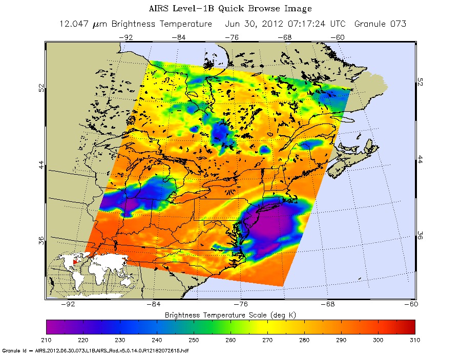
NASA’s Aqua satellite flew over the derecho on June 29 and June 30, using the Atmospheric Infrared Sounder instrument (AIRS) onboard to capture infrared imagery of the event, as seen above.

“The AIRS infrared image shows the high near-surface atmospheric temperatures blanketing the South and Midwestern U.S., approaching 98 degrees Fahrenheit,” said Ed Olsen of the AIRS Team at NASA’s Jet Propulsion Laboratory.

The AIRS images for June 30 show areas of intense convection centered off the New Jersey coast and another, less intense, system over Iowa-Indiana-Ohio. The area off the New Jersey coast is no longer a rapidly moving linear front. The near-surface atmospheric temperatures over the South and Midwest had decreased by 10 to 15 Fahrenheit in most areas,” Olsen said.

NASA’s Suomi National Polar-orbiting Partnership satellite (NPP) captured night-time images on June 28 and June 30, that reflected the massive blackouts that occurred after the derecho swept through the mid-Atlantic states. You can see the comparison images here at NASA’s Earth Observatory website.

The mechanics of a derecho go like this: The downburst mentioned by Witte, above, occurs when cold air in the upper atmosphere is cooled more by the evaporation of some of the rain and melting of the frozen precipitation pushed up into the high levels of the towering cumulonimbus (thunderclouds). That cold air becomes much denser than the surrounding air and literally falls to the ground, accelerating like any other falling body.

“The huge blob of very cold air from the upper atmosphere has a higher forward wind speed since it is high in the atmosphere,” Witte said. “This gives the ‘blob’ great forward momentum. Add that speed to the falling speed and the result is a very powerful forward moving surface wind.”

The process of a derecho can become self-sustaining as hot and humid air is forced upward by the gust front and develops more (reinforcing) towering clouds. If there is a rear low level jet stream, there is nothing to stop the repeating process.

You can find out more information about derechos at this NOAA page.

Source: NASA

Smoking Wildfires Seen From Space

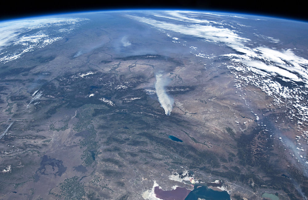
Wildfires continue to rage across the western United States, burning forests and property alike, and even the most remote have sent up enormous plumes of smoke that are plainly visible to astronauts aboard the Space Station.

The photo above was taken by an Expedition 31 crew member on June 27, showing thick smoke drifting northeast from the Fontenelle fire currently burning in Wyoming. More plumes can be seen to the north.

Utah’s Great Salt Lake can be seen at the bottom right of the image. Its two-tone coloration is due to different species of algae that live in the lake, which is split by the physical barrier of a railroad causeway.

You can watch a video of the wildfires in the west taken from the ISS here, and see more “fire and smoke” news and images from space here.

Image: NASA

Pacific Glory

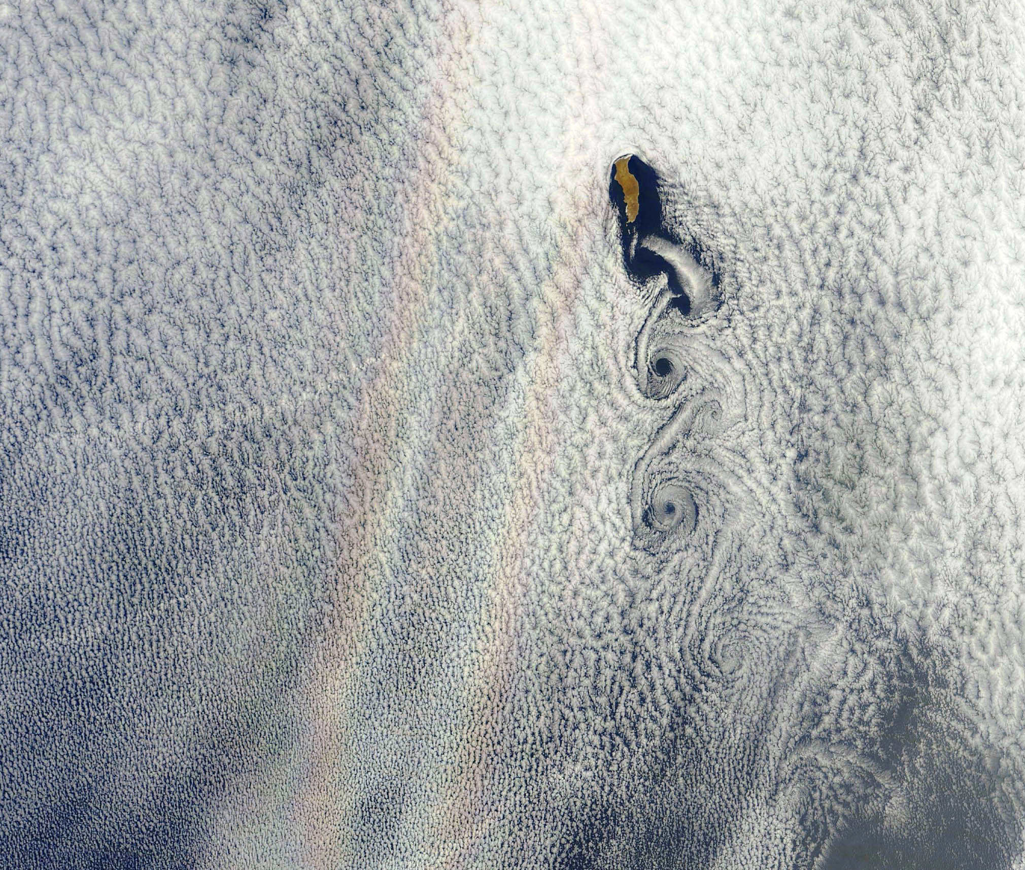
An optical phenomenon known as a “glory” is seen over a cloud-covered Pacific Ocean in this image from NASA’s Aqua satellite, acquired on June 20, 2012. Although the colors may make it look like a rainbow, the process behind its formation is somewhat different.

As vortices spiral off the leeward side of Guadalupe Island, off the western coast of Baja California, a shimmering spectrum of colors highlights a glory just west of the island. Glories are created when light from the Sun reflects back toward an observer off water droplets within clouds or fog. They are often seen from airplanes as a bright ring of light encircling a silhouetted shadow of the aircraft below, but are also visible from the ground and, sometimes, even from space.

From the NASA Earth Observatory website:

Although glories may look similar to rainbows, the way light is scattered to produce them is different. Rainbows are formed by refraction and reflection; glories are formed by backward diffraction. The most vivid glories form when an observer looks down on thin clouds with droplets that are between 10 and 30 microns in diameter. The brightest and most colorful glories also form when droplets are roughly the same size.

From the ground or an airplane, glories appear as circular rings of color. The space shuttle Columbia observed a circular glory from space in 2003. In the image above, however, the glory does not appear circular. That’s because MODIS scans the Earth’s surface in swaths perpendicular to the path followed by the satellite. And since the swaths show horizontal cross sections through the rings of the glory, the glory here appears as two elongated bands of color that run parallel to the path of the satellite, rather than a full circle.

Glories always appear around the spot directly opposite the Sun, from the perspective of the viewer. This spot is called the anti-solar point. To visualize this, imagine a line connecting the Sun, a viewer, and the spot where the glory appears. In this case, the anti-solar point falls about halfway between the two colored lines of the glory.

Click here to download the full-size image.

NASA image courtesy Jeff Schmaltz, LANCE MODIS Rapid Response. Read more here.

Tropical Storm Debby Douses the Gulf

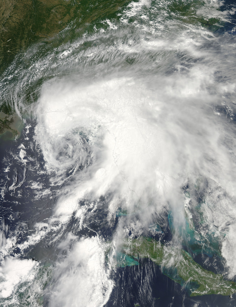
Satellite image of tropical storm "Debby" over the Gulf

The eastern Gulf of Mexico is getting lashed by tropical storm Debby, which whipped up tornado-spawning winds and dumped inches of rain across much of Florida, Mississippi, Alabama and southern Georgia over the weekend. NASA’s Aqua satellite acquired this image on June 23, just after the depression strengthened to full tropical storm status.

Born over the warm, moist air of the Gulf off the coast of Mississippi on Saturday afternoon, Debby quickly strengthened to storm status with sustained winds currently reported at over 60 mph. Slow-moving at a 6 mph crawl to the northeast, Debby continues to drench the Gulf state coasts with inches of rain — up to 10 to 20 inches projected for some areas. Major flooding has already become a problem and reports of tornadoes have been coming in since Sunday afternoon.

Debby will likely become a hurricane at some point, although her future path is still not entirely known.

Launched on May 4, 2002, NASA’s Aqua satellite specializes in keeping track of the movement of water around the planet in all its various forms. Find out more about the Aqua mission here.

Image: NASA/GSFC/Jeff Schmaltz/MODIS Land Rapid Response Team

Huge Wildfires Burn on Opposite Sides of the Planet

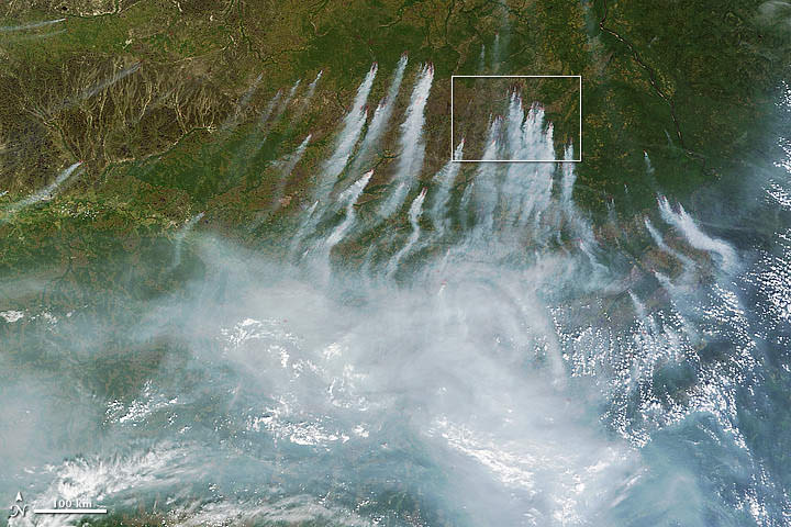
The latest views of Earth from NASA’s Aqua and Terra satellites are looking a bit hazy from wildfires burning in wilderness areas of the United States and Siberia.

The above image acquired July 18 from the Moderate Resolution Imaging Spectroradiometer, or MODIS, aboard the Terra satellite, shows a whopping 198 wildfires burning across Siberia. You can view more of this huge fire at NASA’s Earth Observatory website. The fires have charred an area of more than 83 square kilometers. Some of the fires were started by people who lost control of agricultural fires but some fires were started by lightning.

High Park Fire from NASA's Aqua MODIS
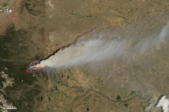
Another NASA earth-observing satellite, Aqua, has taken dramatic images of the High Park Fire just west of Fort Collins, Colorado and the Whitewater-Baldy Complex Fire in southwestern New Mexico. The High Park Fire has grown to more than 235 square kilometers, burning 180 structures and leading to the death of one person. It has become one of the most destructive and largest fires in Colorado history. Thankfully, the

Besides measuring the smoke plume and fire extent, much can be learned using satellite images of wildfires. Types of vegetation can affect the type and color of smoke emitted by the wildfire. Grassland fires tend to burn quickly and give off carbon-rich black smoke. Forest fires where moisture is higher give off thicker smoke; a combination of organic rich ash and water vapor, that ranges in color from brown to bright white.

Pyrocumulus cloud from High Park Fire, ColoradoOn the plus side for weather buffs, each of the fires have produced rare pyrocumulus, or fire clouds. Wildfires and volcanos can produce these dramatic clouds as intense heating causes the air to rise. As the rising air cools, water vapor in the ash cloud condenses just like a normal cloud. The ash particles provide nuclei for water to condense. Sometimes this moisture will fall back on the fire as rain. Dave Lipson, a meteorologist with the National Oceanic and Atmospheric Administration told the Denver Post that calm and clear weather along Colorado’s Front Range made the towering pyrocumulus cloud look especially menacing Tuesday. Tuesday afternoon, the lone fire cloud could be seen from 40 miles away from Denver.

Lead image caption: NASA image courtesy Jeff Schmaltz, LANCE MODIS Rapid Response. Instrument: Terra – MODIS

Second image caption: High Park Fire, Colorado from NASA’s Aqua MODIS

Third image caption: Looking north near Boulder, Colorado at the pyrocumulus cloud produced from the High Park Fire. Photo: John Williams

Blue Marble 2012: The Arctic Edition

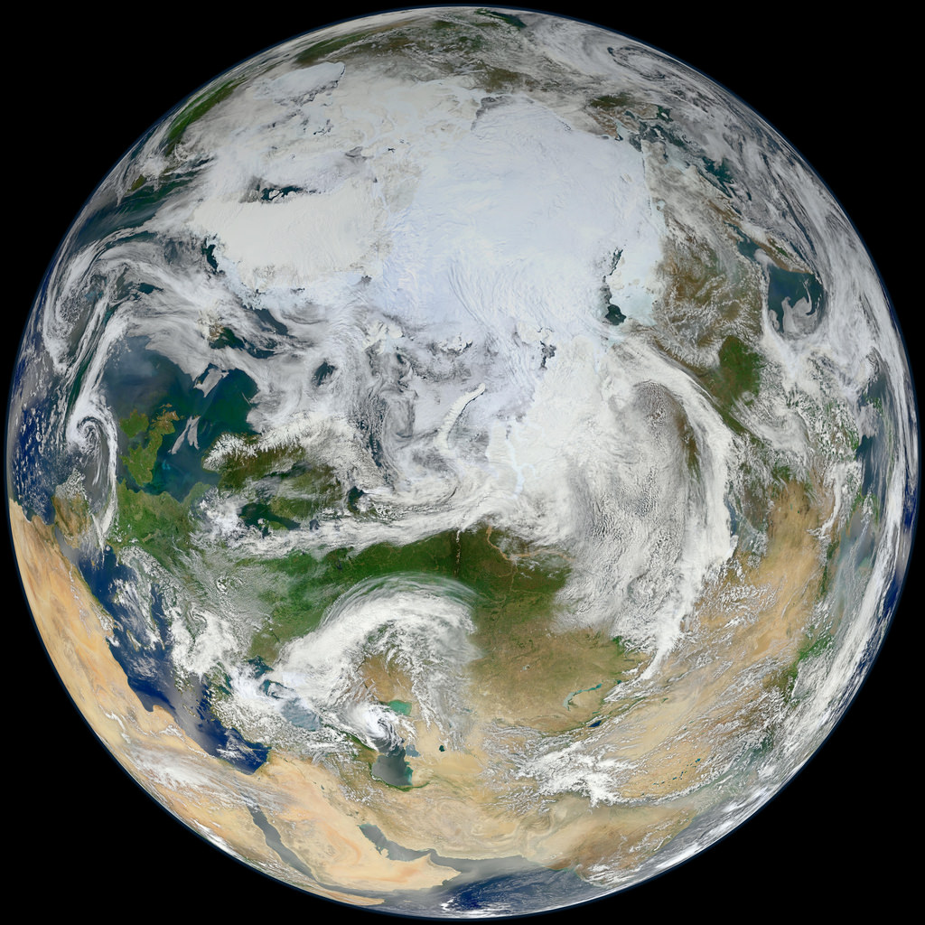
This latest portrait of Earth from NASA’s Suomi NPP satellite puts the icy Arctic in the center, showing the ice and clouds that cover our planet’s northern pole. The image you see here was created from data acquired during fifteen orbits of Earth.

In January of this year Suomi NPP images of Earth were used to create an amazing “Blue Marble” image that spread like wildfire across the internet, becoming one of the latest “definitive” images of our planet. Subsequent images have been released by the team at Goddard Space Flight Center, each revealing a different perspective of Earth.

See a full-sized version of the image above here.

NASA launched the National Polar-orbiting Operational Environmental Satellite System Preparatory Project (or NPP) on October 28, 2011 from Vandenberg Air Force Base. On Jan. 24, NPP was renamed Suomi National Polar-orbiting Partnership, or Suomi NPP, in honor of the late Verner E. Suomi. It’s the first satellite designed to collect data to improve short-term weather forecasts and increase understanding of long-term climate change.

Suomi NPP orbits the Earth about 14 times each day and observes nearly the entire surface of the planet.

Image credit: NASA/GSFC/Suomi NPP


There’s a Hole in the Sky!

A vast hole in the cloud cover seen over the southern Pacific

[/caption]

Well, not the sky exactly, but definitely in the clouds!

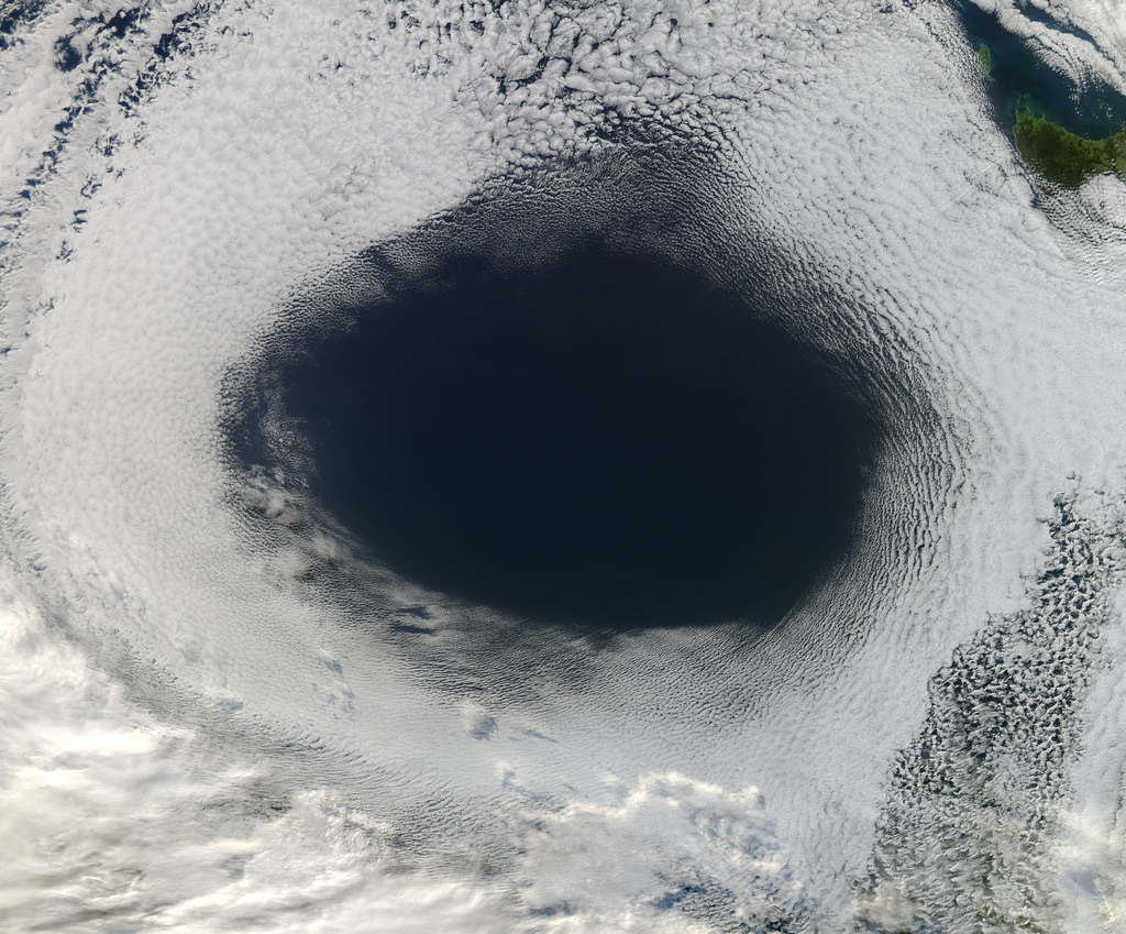
This image, acquired by NASA’s Aqua satellite on June 5, shows an enormous oval hole in the clouds above the southern Pacific Ocean, approximately 500 miles (800 km) off the southwestern coast of Tasmania. The hole itself is several hundred miles across, and is the result of high pressure air in the upper atmosphere.

According to Rob Gutro of NASA’s Goddard Space Flight Center, “This is a good visible example of how upper-level atmospheric features affect the lower atmosphere, because the cloud hole is right under the center of a strong area of high pressure. High pressure forces air down to the surface blocking cloud formation. In addition, the altocumulus clouds are rotating counter-clockwise around the hole, which in the southern hemisphere indicates high pressure.”

The northwestern tip of Tasmania and King Island can be seen in the upper right of the image.

The Aqua mission is a part of the NASA-centered international Earth Observing System (EOS). Launched on May 4, 2002, Aqua has six Earth-observing instruments on board, collecting a variety of global data sets about the Earth’s water cycle. Read more about Aqua here.