Unexpected Find: ‘Rainforest’ of Phytoplankton Growth in the Arctic Ocean

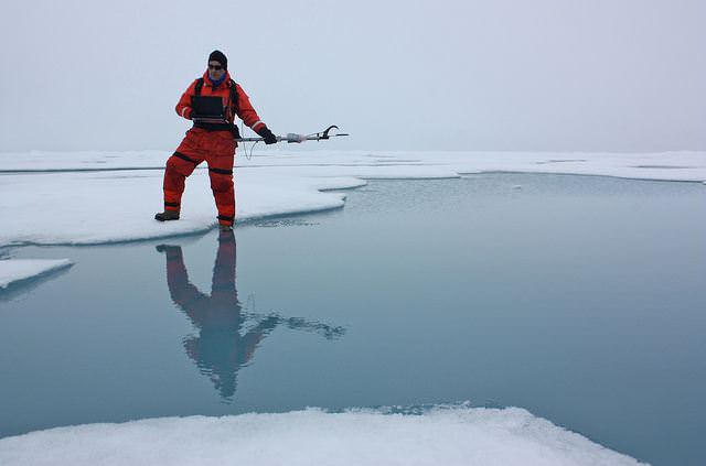
Don Perovich, part of the ICESCAPE mission used a spectroradiometer to measure the amount of sunlight reflected from the surface of ice and melt ponds in the Chukchi Sea. Credit: NASA/Kathryn Hansen

[/caption]

Imagine finding a rainforest in the middle of a desert. That is how NASA scientists are equating a new biological discovery in Arctic Ocean. Microscopic plants called phytoplankton are actively growing under the thinning Arctic ice. In fact, the scientists say the phytoplankton growth in the Arctic may now be richer than any other ocean region on Earth. The finding reveals a new consequence of the Arctic’s warming climate, and gives researchers an important clue to understanding the impacts of a changing climate and environment on the Arctic Ocean and its ecology.

“If someone had asked me before the expedition whether we would see under-ice blooms, I would have told them it was impossible,” said Kevin Arrigo of Stanford University, leader of the ICESCAPE mission and lead author of the new study. “This discovery was a complete surprise.”

ICESCAPE, stand for Impacts of Climate on EcoSystems and Chemistry of the Arctic Pacific Environment and in 2010 and 2011, scientists explored Arctic waters in the Beaufort and Chukchi seas along Alaska’s western and northern coasts onboard a U.S. Coast Guard icebreaker. The researchers drilled down through three-foot thick sea ice to study impacts of environmental variability and change in the Arctic on the ocean biology, ecology and biogeochemistry.

The researchers found the phytoplankton were extremely active, doubling in number more than once a day. Conversely, blooms in open waters grow at a much slower rate, doubling in two to three days. These growth rates are among the highest ever measured for polar waters.

Phytoplankton were thought to grow in the Arctic Ocean only after sea ice had retreated for the summer.

In July of 2011 the researchers observed blooms beneath the ice that extended from the sea-ice edge to 72 miles into the ice pack. Ocean current data revealed that these blooms developed under the ice and had not drifted there from open water, where phytoplankton concentrations can be high.

Previously, it was thought that sea ice blocked most sunlight needed for phytoplankton growth. Scientists now think that the thinning Arctic ice is allowing sunlight to reach the waters under the sea ice, spurring plant blooms where they had never been observed. The findings were published today in the journal Science.

Phytoplankton is the base of the marine food chain and they consume large amounts of carbon dioxide. Scientists will have to reassess the amount of carbon dioxide entering the Arctic Ocean through biological activity if the under-ice blooms turn out to be common.

“At this point we don’t know whether these rich phytoplankton blooms have been happening in the Arctic for a long time and we just haven’t observed them before,” Arrigo said. “These blooms could become more widespread in the future, however, if the Arctic sea ice cover continues to thin.”

The discovery of these previously unknown under-ice blooms also has implications for the broader Arctic ecosystem, including migratory species such as whales and birds. Phytoplankton are eaten by small ocean animals, which are eaten by larger fish and ocean animals. A change in the timeline of the blooms can cause disruptions for larger animals that feed either on phytoplankton or on the creatures that eat these microorganisms.

“It could make it harder and harder for migratory species to time their life cycles to be in the Arctic when the bloom is at its peak,” Arrigo said. “If their food supply is coming earlier, they might be missing the boat.”

The scientists said the discovery also may have major implications for the global carbon cycle and the ocean’s energy balance, and they may need to revise their understanding of the ecology of the Arctic and the region’s role in the Earth system.

You can see more images from the ICESCAPE expedition on NASA Goddard’s Flickr page.

The team’s paper: K.R. Arrigo et al. Massive phytoplankton blooms under Arctic sea ice. Science. doi:10.1126/science.1215065.

Source: NASA

SpaceX Dragon Spies Earth

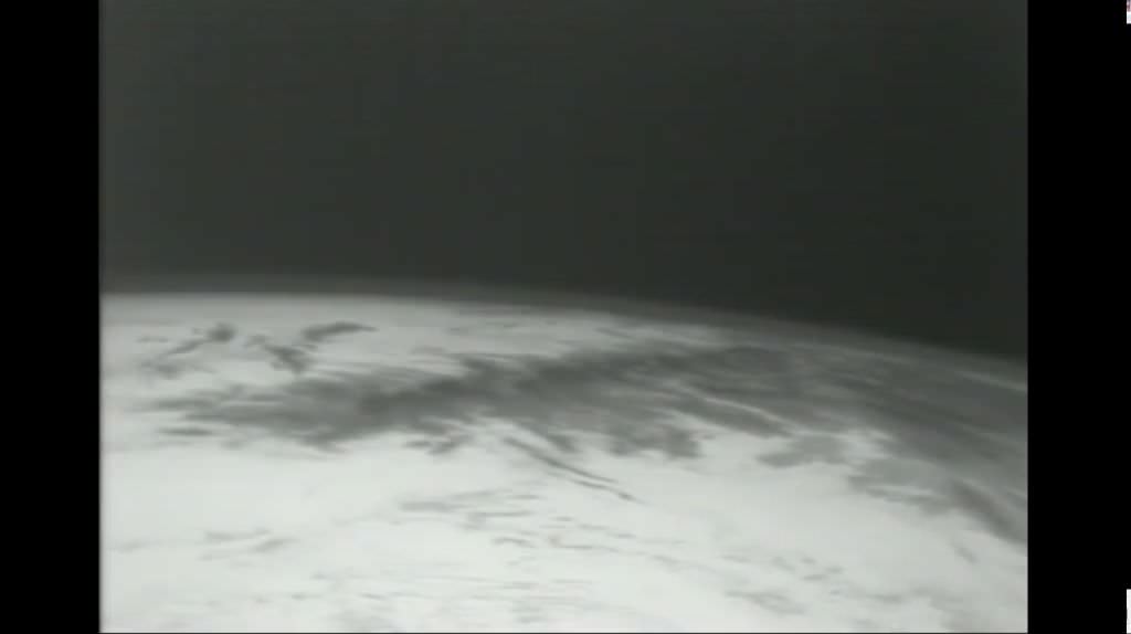
The Earth from SpaceX Dragon cargo vehicle after May 22, 2012 balastoff. Credit: SpaceX

[/caption]

All systems are functioning nominally aboard the Earth orbiting Dragon cargo carrier launched yesterday, May 22, atop the SpaceX Falcon 9 rocket from Cape Canaveral, Florida.

SpaceX has released the picture above of the Earth as seen by a thermal imager that Dragon will use in its upcoming approach to the International Space Station.

The Falcon 9/Dragon duo thundered to space at 3:44 a.m. on May 22 from Space Launch Complex-40 at Cape Canaveral Air Force Station on a historic mission to be the first private spacecraft to dock at the International Space Station (ISS).

Docking is expected on Friday morning May 25 after an intricate series of maneuvering tests are conducted to prove that the Dragon spacecraft can safely approach and dock at the ISS.

Dragon is loaded with about 1200 pounds of supplies on a test flight aimed at showing it can partially replace the cargo carrying duties of the now retired NASA space shuttles.

Watch NASA TV for live docking coverage

Read my launch article here

Ken Kremer

The Other End of an Eclipse

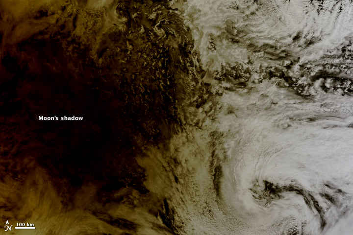
The Moon's shadow falling over the Pacific on May 20, 2012

[/caption]

As the annular eclipse on May 20 sent skywatchers around the globe gazing upwards to see the Sun get darkened by the Moon’s silhouette, NASA’s Terra satellite caught the other side of the event: the Moon’s shadow striking the Earth!

Cast across 240,000 miles of space, the lunar shadow darkened a circular swatch 300 km (185 miles) wide over the northern Pacific Ocean in this image, acquired by the Earth-observing Terra satellite’s Moderate Resolution Imaging Spectroradiometer (MODIS) at 20:30 UT on Sunday, May 20.

From the NASA Earth Observatory site:

Where the Moon passed in front of the Sun, Earth’s surface appeared black (left half of image). Around the margins of the shadow, our planet’s surface appeared yellowish brown. The shadow cast by an eclipse consists of two parts, the completely shadowed umbra and the partially shadowed penumbra.

The eclipse was first visible over eastern Asia and moved across the globe, later becoming visible on the west coast of the US. Known as an annular eclipse, even in totality there was a bright ring of Sun visible around the Moon — a result of the Moon’s elliptical orbit. The effect was dramatic, and was captured in some amazing photos from viewers around the world (as well as by a few above the world!)

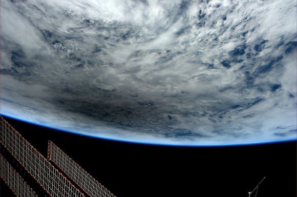
Looking at Earth during the Annular Solar Eclipse of May 20, 2012, photographed by Don Pettit from the International Space Station at 23:36 GMT. (NASA)

Although there were a few images being circulated online of the “eclipse” that were not actual photos, be assured that these are the real deal.

And the next eclipse event? That will occur on November 13 of this year, when a total eclipse will be visible from Australia, the South Pacific and South America. Watch an animation of the Nov. 13 eclipse visibility here.

Top image: NASA/Jeff Schmaltz, LANCE MODIS Rapid Response.

Watch How Life Recovers from Devastation

If a portion of Earth underwent a major cataclysm, how long would it take for life to recover? The 1980 eruption of Mount St. Helens is giving scientists an unprecedented opportunity to witness a recovery from devastation, as the eruption leveled the surrounding forest, blasted away hundreds of meters of the mountain’s summit, and claimed 57 human lives. Landsat satellites have tracked the what has happened on the mountain, and how the forest was reclaimed — all on its own. This video shows a timelapse of the recovery, with annual images from 1979-2011 from the Landsat satellites, which acquired the images seen here between 1979 and 2011.
Continue reading “Watch How Life Recovers from Devastation”

Stunning Timelapse of Planet Earth from Elektro-L

We’ve shared the images and a previous timelapse of Earth’s northern hemisphere, but now here’s a breath-taking timelapse of the entire blue (and green!) marble as seen from Russia’s Elektro-L weather-forecasting satellite, orbiting at a geostationary height of about 36,000 km (22,300 miles). This new video was created by James Drake using some of the largest whole disk images of our planet, as each image is 121 megapixels, and the resolution is 1 kilometer per pixel. The satellite’s wide-angle Multichannel Scanning Unit (MSU) takes images every 15-30 minutes, showing the same viewpoint of Earth across progressive times of the day and the images are in four different wavelengths of light — three visible, and one infrared.

It’s a beautiful view of home.
Continue reading “Stunning Timelapse of Planet Earth from Elektro-L”

The End Of Envisat

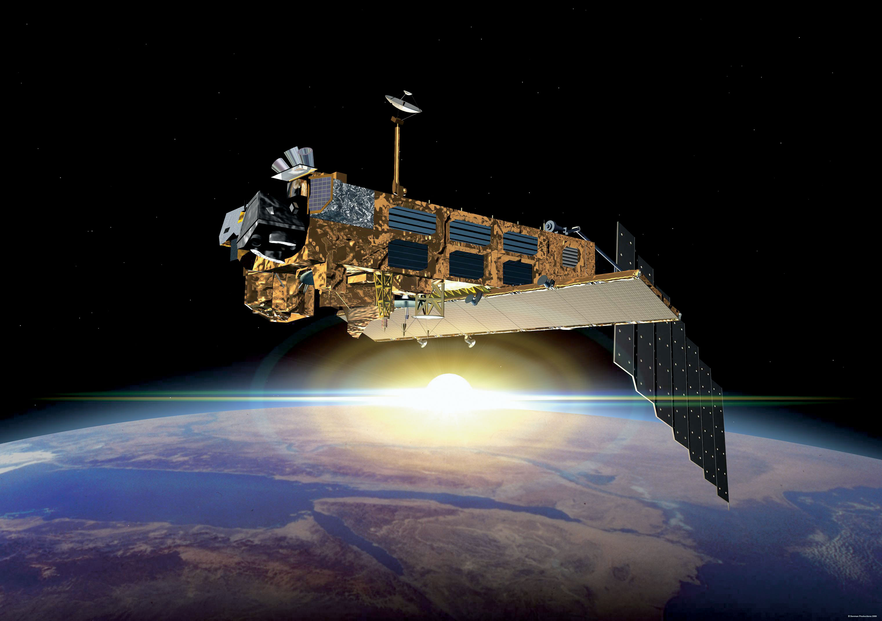
After ten years in orbit Envisat's mission has been declared over. (ESA)

[/caption]

Well, it’s official. After ten years of groundbreaking observation of our planet, ESA has declared the end of the Envisat mission after losing contact with the satellite on April 8, 2012. All attempts to re-establish communication with Envisat have so far been unsuccessful, and although recovery teams will continue to determine the cause of signal loss and try to regain a signal over the next several weeks, the mission — and the satellite — have been retired.

Having performed twice as long as originally planned, the hardworking Envisat has definitely earned its rest.

On April 8, the European Space Agency lost communication with the Earth-observation satellite, preventing reception of data as it passed over the Kiruna station in Sweden. Although later confirmed that the satellite is still in orbit, the recovery team has not been able to re-establish contact.

It’s thought that a loss of a power regulator could be blocking telemetry and telecommands from reaching Envisat, or else the satellite may have experienced a short-circuit and attempted to go into “safe mode” but experienced difficulties during the transition, leaving it in an unknown state.

Read: Is This the Last Image From Envisat?

ESA states that the chances of ever regaining communication with Envisat are extremely low.

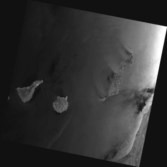
While we had reported before on the last image received before falling silent, the image below is actually the final image from Envisat, an X-band image of the Canary Islands.

The final image from Envisat, acquired on April 8, 2012. (ESA/Edisoft)

During its lifetime, Envisat completed 50,000 orbits of Earth and returned over a thousand terabytes of data, containing invaluable measurements of our planet’s surface and atmosphere that were used in more than 2500 science publications.

The video below gives a fitting eulogy for a satellite that’s definitely overachieved and over-performed, giving us a decade of crucial observations of our world from orbit.

Read more on the ESA news release here.

From Russia With Love: A Singularly Stunning Image of Earth

Full-disk image of Earth from Russia's Elektro-L satellite. (NTs OMZ)

[/caption]

Unlike most satellite images of Earth, this one was not assembled from multiple swath scans or digitally projected onto a globe model — it’s the full disk of our planet in captured as a single, enormous 121 megapixel image, acquired by Russia’s Elektro-L weather-forecasting satellite.

Like NASA’s GOES satellites, Elektro-L is parked in a geostationary orbit approximately 36,000 km (22,300 miles) above our planet. Unlike NASA’s satellites, however, Elektro-L captures images in near-infrared as well as visible wavelengths, providing detail about not only cloud movement but also vegetation variations. Its wide-angle Multichannel Scanning Unit (MSU) takes images every 15-30 minutes, showing the same viewpoint of Earth across progressive times of the day.

At a resolution of 0.62 miles per pixel, full-size Elektro-L images are some of the most detailed images of Earth acquired by a weather satellite.

Download the full-size image here (100+ megabytes).

Elektro-L diagram. © 2009 Anatoly Zak

Launched aboard a Zenit rocket on January 20, 2011, Elektro-L was the first major spacecraft to be developed in post-Soviet Russia. Parked over Earth at 76 degrees east longitude, Elektro-L provides local and global weather forecasting and analysis of ocean conditions, as well as “space weather” monitoring — measurements of solar radiation and how it interacts with Earth’s magnetic field. Its initial lifespan is projected to be ten years.

A second Elektro-L satellite is anticipated to launch in 2013.

Image credit: Russian Federal Space Agency / Research Center for Earth Operative Monitoring (NTS OMZ). See more images and video from Elektro-L on James Drake’s Planet Earth here. (Tip of the geostationary hat to Jesus Diaz at Gizmodo.)

Chaos and Education at 120,000 feet for Camilla the Rubber Chicken

The helium balloon pops at the apex of the flight on March 10, 2012. Credit: Earth to Sky-Bishop CA

[/caption]

In my travels, I’ve had the pleasure of regularly meeting up with Camilla the Rubber Chicken, the social media maven and mascot for NASA’s Solar Dynamics Observatory. But lately I’ve been seeing here virtually everywhere — on television, splashed across all sorts of websites, and even in my local newspaper. What Camilla does is try to capture the imagination of students and get them interested in space and science. With her latest adventures she’s done just that, and now captured the attention of people all around the world, too.

What did she do? She flew to the stratosphere — about 36,000 meters (120,000 ft) up — on a helium balloon right into the throes of one of the most intense solar radiation storms since 2003.

“I am still glowing,” Camilla joked.

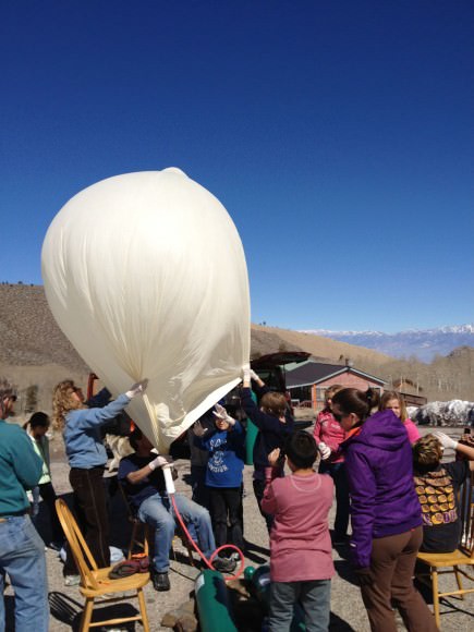
Inflating Camilla's ride. Image courtesy Bishop Union High School.

Students from Bishop Union High School’s Earth to Sky group spearheaded the flights, as Camilla actually flew twice — once on March 3 before the radiation storm and again on March 10 while the storm was in full swing. This would give the students a basis for comparison of the radiation environment.

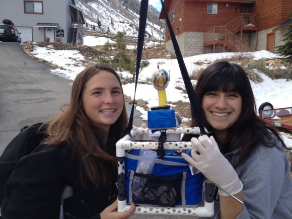
On board with Camilla was a payload of four cameras, a cryogenic thermometer two GPS trackers, radiation detectors, Seven insects and two-dozen sunflower seeds (fittingly, the variety known as “Sunspot” — Helianthus annuus) all inside a modified department store lunchbox.

“We equipped Camilla with sensors to measure the radiation,” says Sam Johnson, 16, of Bishop Union High School’s Earth to Sky student group. “At the apex of our flight, the payload was above 99 percent of Earth’s atmosphere.”

Camilla made it back in one piece, but unfortunately, the insects died.

“This story is really about STEM (science, technology, engineering and math) and about these kids from Bishop, California who have worked really hard in developing the mission, planning it, and then executing it,” Camilla told Universe Today. “They had to overcome set-backs, review their processes, come up with better solutions and implement them. For them it was a great hands-on learning experience and they are and can be proud of their accomplishments.”

NASA knows that these kinds of programs, where kids can get involved in hands-on research, are very important for introducing and keeping students interested in STEM subjects, important areas of study for future NASA scientists and engineers.

“As you know, I not only want to educate about our Sun and space weather, but I want to inspire and show kids (and adults) how much fun science and engineering really is,” Camilla said via email. “Team SDO’s goal has always been to encourage more girls into STEM careers and seeing that this team had several girls on the team was just the most rewarding.”

Students prepare Camilla for her ride into the stratosphere. Image courtesy Bishop Union High School.

The video of the balloon popping and part of Camilla’s flight:

During the two-and-a-half-hour flights, Camilla spent approximately 90 minutes in the stratosphere where temperatures ( -40 to -60 C, -40 to -76 F) and air pressures (1 percent sea level) are akin to those on the planet Mars. The balloon popped, as planned, at an altitude of about 40 km (25 miles) and Camilla parachuted safely back to Earth. The entire payload was recovered intact from a landing site in the Inyo Mountains.

The fifth grade students who assisted with the flight have planted the sunflower seeds to see if radiated seeds produce flowers any different from seeds that stayed behind on Earth. They also pinned the corpses of the insects to a black “Foamboard of Death,” a rare collection of bugs that have been to the edge of space.

Meanwhile, Camilla’s radiation badges have been sent to a commercial laboratory for analysis.

The students say they are looking forward to the data and perhaps sending Camilla back for more.

“I truly believe that text books will always be around,” Camilla said, “but real-life hands-on projects like these are wonderful, and will become more popular.”

Here’s a video of an X-class flare from sunspot AR1429, which unleashed more than 50 solar flares during the first two weeks of March:

Read more about Camilla’s adventures, or our previous article, How a Rubber Chicken is Spreading the Word About NASA’s Space Missions and Science.

View from Orbit of a Huge White Sands Dust Storm

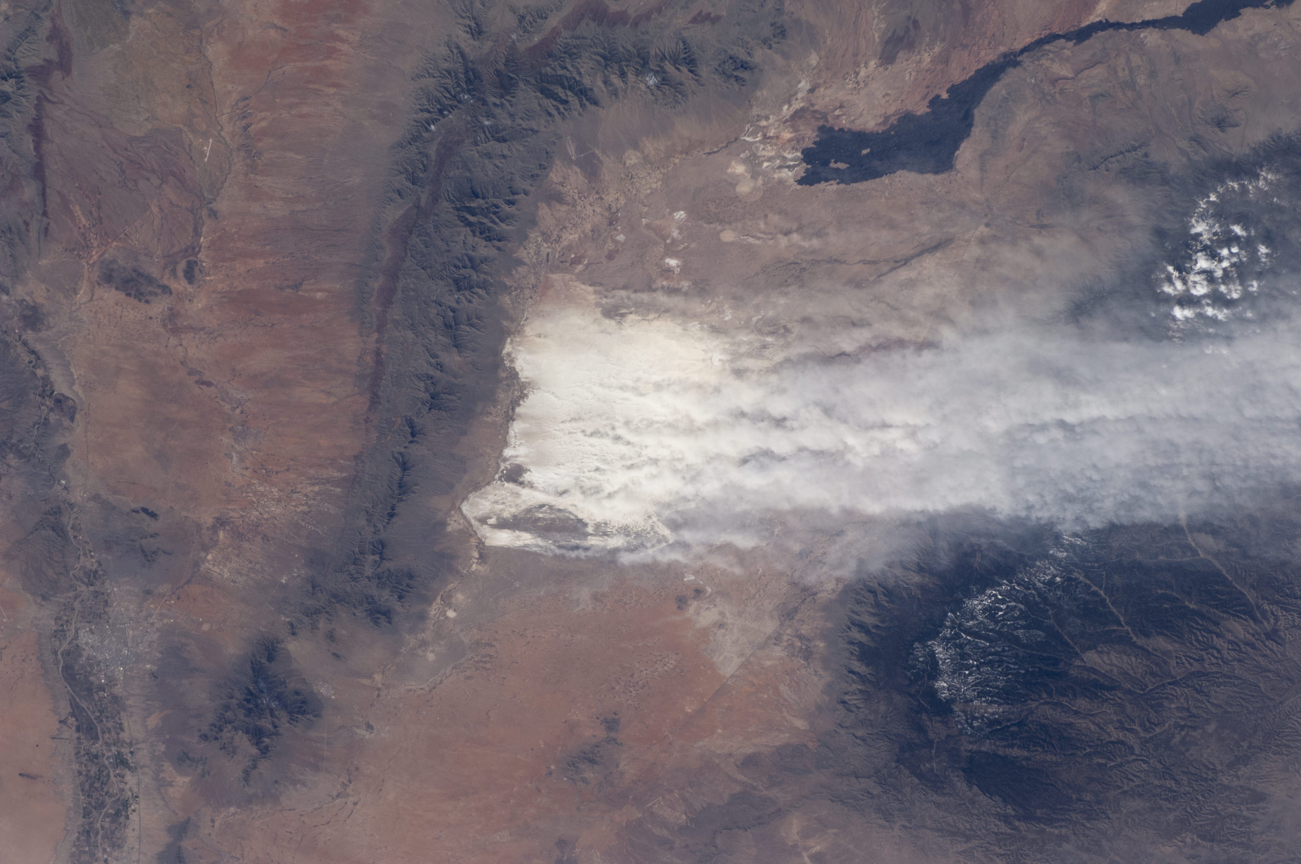
Driven by southwesterly winter winds, dust from the White Sands dune field in New Mexico rises thousands of feet from the valley floor and drifts over the snowy peaks of the Sacramento Mountains. Credit: NASA

[/caption]

It’s clear from this image of why a region in New Mexico, USA is called ‘White Sands.’ The dust plumes in this photograph taken by an astronaut on board the International Space Station show a dust storm in the White Sands National Monument. But this is a huge dust storm. The white dust plumes stretch across more than 120 kilometers (74 miles).

Caused by winds that channel the dust through a low point in the mountains, the vigorous winds are lifting dust particles from the valley floor to more than 1200 meters over the mountains. The Moderate Resolution Imaging Spectroradiometer (MODIS) on NASA’s Aqua satellite also captured a wider, regional view of the same storm on the same day.

The sand dunes of this national monument are white because they are composed of gypsum, a relatively rare dune-forming mineral. The dunes’ brilliance, especially contrasted against the nearby dark mountain slopes, makes them easily identifiable to orbiting astronauts. The white speck of the dunes was even visible to the Apollo astronaut crews looking back at Earth on the way to the Moon.

Source: NASA Earth Observatory

Antarctica’s Ice Being Eaten Away From Below

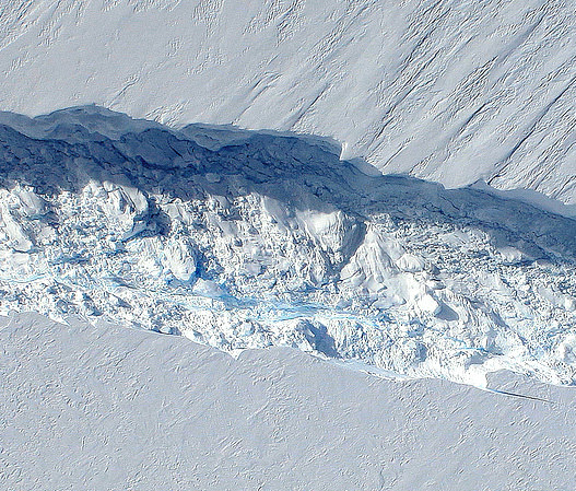
The 820-foot-wide crack in Antarctica's Pine Island Glacier, seen from DC-8 during Operation IceBridge (Credit: NASA/DMS)


Data collected from a NASA ice-watching satellite reveal that the vast ice shelves extending from the shores of  western Antarctica are being eaten away from underneath by ocean currents, which have been growing warmer even faster than the air above.

The animation above shows the circulation of ocean currents around the western Antarctic ice shelves. The shelf thickness is indicated by the color; red is thicker (greater than 550 meters), while blue is thinner (less than 200 meters).

Launched in January 2003, NASA’s ICESat (Ice, Cloud and land Elevation Satellite) studied the changing mass and thickness of Antarctica’s ice from its location in polar orbit. An international research team used over 4.5 million surface height measurements collected by ICESat’s GLAS (Geoscience Laser Altimeter System) instrument from Oct. 2005 to 2008. They concluded that 20 of the 54 shelves studied — nearly half — were losing thickness from underneath.

[/caption]

Most of the melting ice shelves are located in west Antarctica, where the flow of inland glaciers to the sea has also been accelerating — an effect that can be compounded by thinning ice shelves which, when grounded to the offshore seabed, serve as dams to hold glaciers back.

Melting of ice by ocean currents can occur even when air temperature remains cold, maintaining a steady process of ice loss — and eventually increased sea level rise.

“We can lose an awful lot of ice to the sea without ever having summers warm enough to make the snow on top of the glaciers melt,” said Hamish Pritchard of the British Antarctic Survey in Cambridge and the study’s lead author . “The oceans can do all the work from below.”

The study also found that Antarctica’s winds are shifting in response to climate change.

“This has affected the strength and direction of ocean currents,” Pritchard said. “As a result warm water is funnelled beneath the floating ice. These studies and our new results suggest Antarctica’s glaciers are responding rapidly to a changing climate.”

ICESat completed operations in 2010 and was decommissioned in August of that year. Its successor ICESat-2 is anticipated to launch in 2016.

Read more on NASA’s news release here.

Animation credit: NASA/Goddard CGI Lab