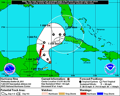
Hurricane Rina's location and forecasted path as of 7 am CDT on Oct 26, 2011. Credit: NOAA
“It’s a big one!” said International Space Station commander Mike Fossum as the space station flew over Hurricane Rina at 2:39 p.m. EDT on Oct. 25, 2011. External cameras on the ISS captured these views as the station flew 248 miles over the Caribbean Sea east of Belize.
Rina’s maximum sustained winds remained steady at about 110 mph early Wednesday, said the U.S. National Hurricane Center in Miami, making it a Category 2 storm. Forecasters predict it will strengthen to a major hurricane as it nears the Mexican coast Wednesday night before rolling over the island of Cozumel, then along the coast to Cancun.
See a map of the Hurricane’s projected path below.
The late season hurricane, which continues to intensify, was located 300 miles east-southeast of Chetumal, Mexico, barely moving west-northwest at a glacial three miles an hour. Hurricane warnings have been issued for the Yucatan from north of Punta Gruesa, Mexico, to Cancun.
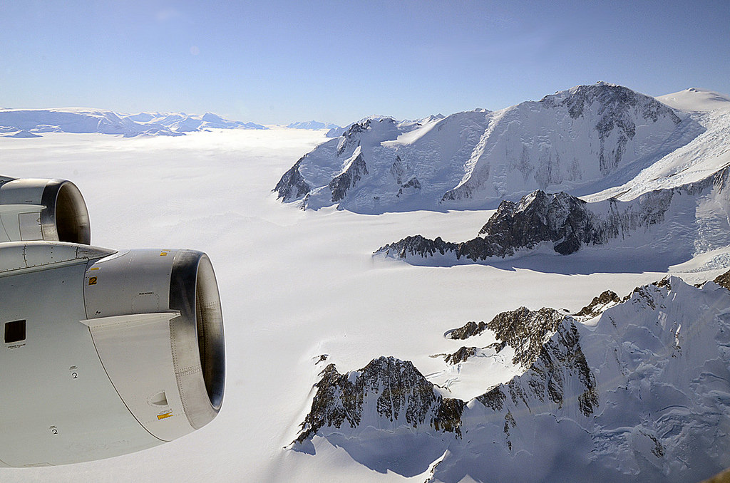
Ice-coated mountaintops of Alexander Island, one of the largest islands off Antarctica. Credit: Michael Studinger/NASA.
[/caption]
Views from the window of NASA’s DC-8 reveal sweeping expanses of ice and rock as part of the ongoing 2011 Operation IceBridge survey of Antarctica’s ice cover.
Now in its third season, Operation IceBridge is a six-year-long mission to study the dynamics of the Antarctic and Arctic ice sheets. It’s the largest ever aerial survey of the polar ice and will yield valuable data on the state of Earth’s vast reservoirs of frozen water, including the land and sea underneath and how they are being affected by today’s rapidly changing climate.
The ridges of the Shackleton Range cast shadows onto Antarctica's ice. Credit: Michael Studinger/NASA.
Researchers – like Michael Studinger, who took the incredible photos seen here – fly over Greenland during the months of March through May and over Antarctica in October and November. NASA’s instrument-laden DC-8 flies over these remote locations at a low altitude of about 1,500 feet, often with little or no advance weather data.
98 percent of Antarctica is covered with ice. Information obtained by Operation IceBridge will be combined with satellite data to create the most accurate models possible of Antarctic ice loss and how it will affect future sea level rise.
Mountains piled with snow and ice rise above the clouds on Alexander Island. Credit: Michael Studinger/NASA.
This season’s Antarctic IceBridge campaign features NASA’s DC-8, at 157 feet long the largest plane in the agency’s airborne research fleet, and will also feature the debut of the Gulfstream V (G-V) operated by the National Science Foundation and National Center for Atmospheric Research.
While the DC-8 flies at low altitudes, the G-V will fly above 30,000 feet to utilize its Land, Vegetation and Ice Sensor (LVIS), which makes detailed topographic studies of the surface.
“With IceBridge, our aim is to understand what the world’s major ice sheets could contribute to sea-level rise. To understand that you have to record how ice sheets and glaciers are changing over time.”
– Michael Studinger, IceBridge project scientist at NASA’s Goddard Space Flight Center in Greenbelt, Md.
The wing of NASA's DC-8 cuts across the frozen expanse of the Brunt Ice Shelf, with its 100-foot-high cliff face. Credit: Michael Studinger/NASA.
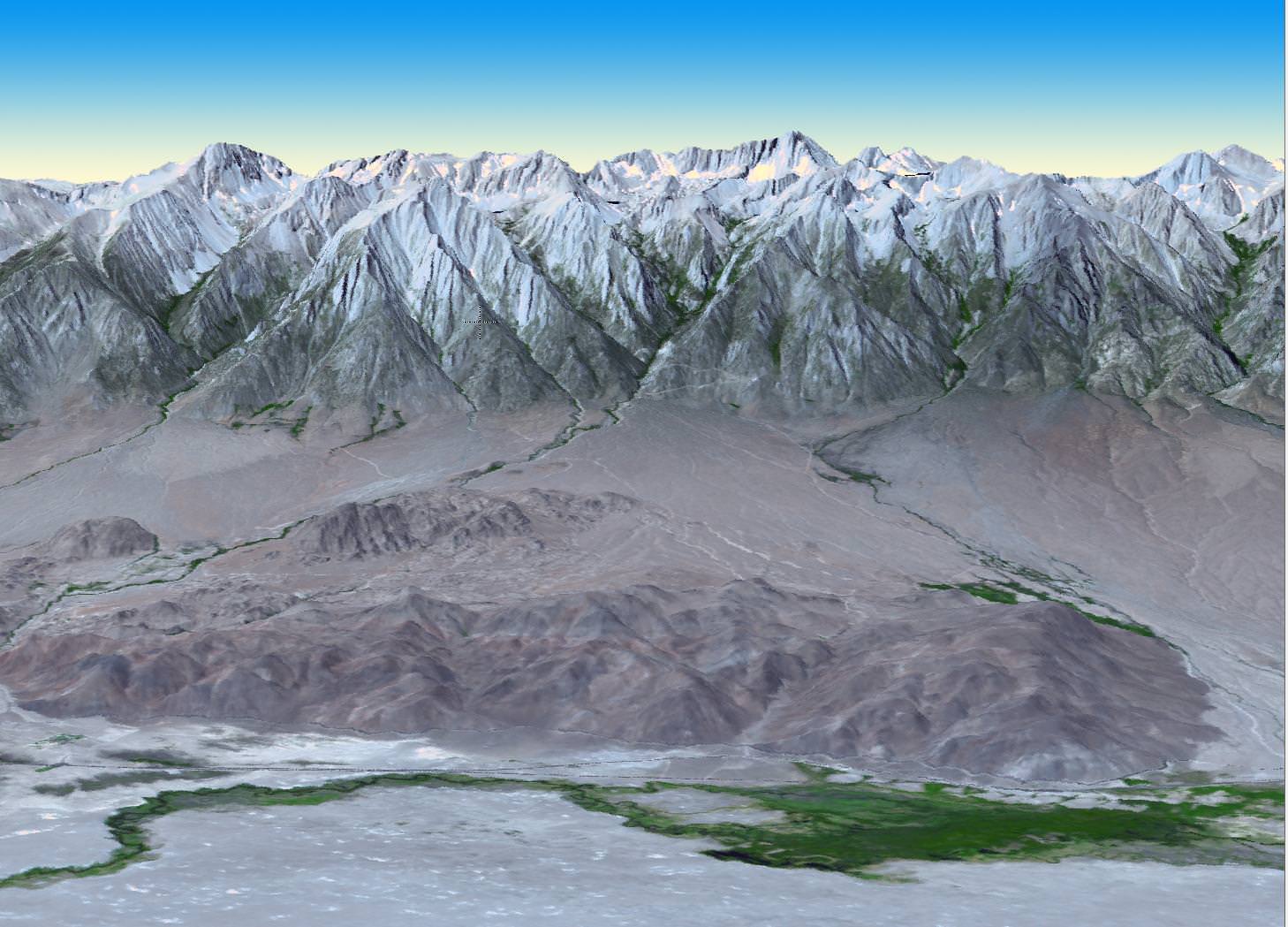
At 4.4 kilometers in elevation, California's Mt. Whitney is the highest point in the continental United States. Image credit: NASA/GSFC/METI/ERSDAC/JAROS, and U.S./Japan ASTER Science Team
[/caption]NASA and Japan recently announced a new and improved digital topographic map of Earth, which was produced with detailed measurements from NASA’s Terra spacecraft.
The new data covers over 99 percent of Earth’s landmass and spans from 83 degrees north latitude to 83 degrees south. Each elevation measurement point in the data is only 30 meters apart.
How were scientists able to improve on previous generations of detailed topographic maps?
The new model, known as a global digital elevation model, was created from images collected by the Japanese Advanced Spaceborne Thermal Emission and Reflection Radiometer, or ASTER, instrument aboard NASA’s Terra spacecraft. To create a “stereo pair” image,scientists can take two slightly offset images and combine them to create a three-dimensional effect of depth.
The previous version of the global digital elevation model was released in June of 2009 by NASA and Japan’s Ministry of Economy, Trade and Industry.
“The ASTER global digital elevation model was already the most complete, consistent global topographic map in the world,” said ASTER program scientist Woody Turner, “With these enhancements, its resolution is in many respects comparable to the U.S. data from NASA’s Shuttle Radar Topography Mission, while covering more of the globe.”
The ASTER team added 260,000 stereo-pair images to improve the previous model, which improved spatial resolution, increased horizontal and vertical accuracy, and provided the ability to identify lakes as small as 1 kilometer in diameter.
“This updated version of the ASTER global digital elevation model provides civilian users with the highest-resolution global topography data available,” said ASTER science team lead Mike Abrams. “These data can be used for a broad range of applications, from planning highways and protecting lands with cultural or environmental significance, to searching for natural resources.”
Arguably one of America's most magnificent national parks is the Grand Canyon in northern Arizona. Image credit: NASA/GSFC/METI/ERSDAC/JAROS, and U.S./Japan ASTER Science Team
Joining together in a collaborative effort, NASA and METI are contributing data for the ASTER topographic map to the Group on Earth Observations, for use in the group’s Global Earth Observation System of Systems. No, the previous statement wasn’t a typo – the “system of systems” is an international effort, which uses shared Earth observation data to help monitor and forecast global environmental changes.
One of five instruments launched on Terra in 1999, ASTER acquires images from visible to thermal infrared wavelengths, with spatial resolutions ranging from about 15 to 90 meters. ASTER’s science team is a joint effort between the United States and Japan.
The ASTER data was validated by NASA, METI, Japan’s Earth Remote Sensing Data Analysis Center (ERSDAC), and the U.S. Geological Survey, with additional support from the U.S. National Geospatial-Intelligence Agency and other collaborators. NASA’s Land Processes Distributed Active Archive Center is handling the distribution of the new ASTER global digital elevation model.
If you’d like to download the ASTER global digital elevation model to study at no cost, you can do so at: https://lpdaac.usgs.gov/ or http://www.ersdac.or.jp/GDEM/E/4.html
To learn more about ASTER, or NASA’s Terra mission, visit: http://asterweb.jpl.nasa.gov/ and http://www.nasa.gov/terra
The Space Shuttle: Celebating Thirty Years Of NASA's First Space Plane is chocked full of great imagery and works to cover each of the shuttle's 135 missions. Photo Credit: Zenith Press
[/caption]
The space shuttle program is over. The orbiters are being decommissioned, stripped of the components that allowed them to travel in space. For those that followed the program, those that wished they did and those with only a passing interest in what the program accomplished a new book has been produced covering the entirety of the thirty years that comprised NASA’s longest human space flight program. The Space Shuttle: Celebrating Thirty Years of NASA’s First Space Plane is written by aerospace author Piers Bizony and weighs in at 300 pages in length.
Bizony is a prolific author who has focused a lot of his work on space flight. Some of the books that he has written include (but definitely are not limited to) include: One Giant Leap: Apollo 11 Remembered, Space 50, The Man Who Ran the Moon: James E. Webb, NASA, and the Secret History of Project Apollo and Island in the Sky: The International Space Station.
Bizony pulls out all the stops in detailing the shuttle era. From thunder and light - to tragedy, the full spectrum of the shuttle program is highlighted here. Photo Credit: NASA
The book contains 900 color images, detailing the entire history of NASA’s fleet of orbiters. From the first launches and the hope that those initial flights were rich in, to the Challenger tragedy and the subsequent realization that the space shuttles would never be what they were intended to be.
The next phase of the book deals with the post-Challenger period and how NASA worked to find a balance with its fleet of orbiters, while at the same time worked to regain the trust of the America public. The path was both hindered and helped by a single payload – the Hubble Space Telescope.
The Space Shuttle: Celebrating Thirty Years of NASA’s First Space Plane - has stunning imagery on every page, allowing the reader to once again view the majesty that the shuttle program provided. Photo Credit: NASA
When the images the orbiting telescope beamed back turned out fuzzy, NASA was a laughing stock. Hubble would become a sensation and NASA redeemed its name after the first servicing mission to Hubble corrected the problem with the telescope’s mirror.
Hubble was not the only telescope or probe that the shuttle placed in the heavens. It would however, be the only one that NASA’s fleet of orbiters would visit during several servicing missions. Besides Hubble the shuttle also sent the Chandra X-Ray telescope, Galileo probe to Jupiter and the Magellan probe to Venus during the course of the program’s history.
It is currently unknown when the U.S. will launch crews into orbit again. Some aerospace experts have even suggested that the shuttles be pulled out of retirement to help fill this gap - but this is highly unlikely to happen. Photo Credit: NASA
NASA was now on course to begin construction of the most ambitious engineering feat in human history – the International Space Station. The Space Shuttle: Celebrating Thirty Years of NASA’s First Space Plane details this period, as well as the tragic loss of the shuttle Columbia in 2003 with great care and attention to detail. Many never-before-seen images are contained within and Bizony uses them to punctuate the history that the space shuttle accomplished with every flight.
With a chance of catastrophic failure estimated by some as being as high as one chance in 53 - the shuttle was a risky endeavor. However, given all of the program's accomplishments - it is not a stretch to say that the shuttle made fact out of last century's science fiction. Photo Credit: NASA
The book also contains a detailed diagram of the orbiter (it is long and therefore was produced as a pull-out section. This element is included near the end and acts as a nice punctuation mark to the stream of imagery contained within.
While it required the combined effort of 16 different nations to make the International Space Station work - the space shuttle made the orbiting laboratory a reality. Photo Credit: NASA
The book is not perfect (but what book is). If one did not know better, upon reading this book one would assume that the Delta Clipper (both DC-X and DC-XA) flew once and upon landing caught fire. DC-X flew eight times – not once. Bizony also describes the lunar element of the Vision for Space Exploration (VSE) as being a repeat of Apollo. Apollo 17 was the longest duration that astronauts roamed the Moon’s surface – they were there for about three days. The VSE called for a permanent crewed presence on the moon.
For those out there that consider themselves “shuttle huggers” this book is simply a must-have. It is perfect to take to autograph shows to be signed by astronauts (as every mission is detailed, it is a simple matter to have crew members sign on the pages that contain their missions). It is also a perfect gift for space aficionados this holiday season. Published by Zenith Press and retailing for $40.00, The Space Shuttle: Celebrating Thirty Years of NASA’s First Space Plane is a welcome addition to your home library.
How will the shuttle be remebered? According to Bizony, given the technological restraints and the numerous accomplishments that the orbiter accomplished - it will be remembered in a positive light. Photo Credit: NASA
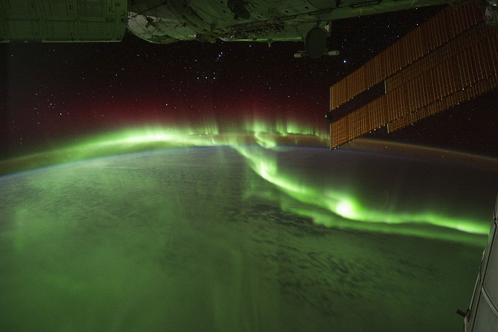
The aurora australis seen from the ISS on September 17, 2011. Credit: NASA.
[/caption]
With all of the activity that’s been occurring on the Sun recently, the aurorae have been exceptionally bright and have created quite a show to viewers – both on Earth as well as above it!
The image above was taken over the southern Indian Ocean by astronauts aboard the International Space Station. The southern lights – a.k.a. aurora australis – glow bright green and red in the upper layers of the atmosphere, creating a dazzling aerial display. (Click here to watch a movie of this.)
Shortly after, fires can be seen on the ground as the ISS passes over Australia:
Wildfires in Australia seen from orbit. Credit: NASA.
Astronauts on the International Space Station (ISS) used a digital camera to capture several hundred photographs of the aurora australis, or “southern lights,” while passing over the Indian Ocean on September 17, 2011. You can see the flowing ribbons and rays below as the ISS passed from south of Madagascar to just north of Australia between 17:22 and 17:45 Universal Time. Solar panels and other sections of the ISS fill some of the upper right side of the photograph.
Auroras are a spectacular sign that our planet is electrically and magnetically connected to the Sun. These light shows are provoked by energy from the Sun and fueled by electrically charged particles trapped in Earth’s magnetic field, or magnetosphere. In this case, the space around Earth was stirred up by an explosion of hot, ionized gas from the Sun — a coronal mass ejection — that left the Sun on September 14, 2011.
In the second image above, and in the last frames of the movie, light from the ground replaces the light show in the sky. Wildfires and perhaps some intentionally set agricultural fires burn on the continent of Australia,with smoke plumes faintly visible in the night sky. A gold and green halo of atmospheric airglow hangs above the horizon in the distance.
______________
Airglow is created by particles in the upper atmosphere that have been charged by UV light from the Sun during the day releasing the energy at night as greenish-yellow visible light.
Fires on the ground, fires in the sky… the stars blazing all around, the Sun in its full glory and a never-ending view of our entire planet… what an incredible place the ISS must be to work in! Absolutely amazing!
And the skies of night were alive with light, with a throbbing, thrilling flame; Amber and rose and violet, opal and gold it came. It swept the sky like a giant scythe, it quivered back to a wedge; Argently bright, it cleft the night with a wavy golden edge.
— “The Ballad of the Northern Lights”, Robert Service
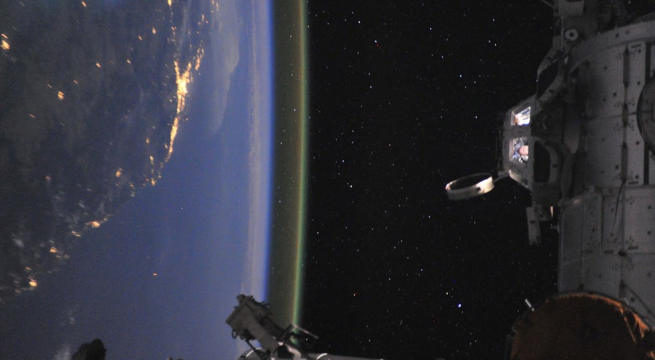
Astronaut Ron Garan in the cupola of the International Space Station off the coast of Australia. Credit: NASA
[/caption]
This has become my new favorite space photo! Look closely into the windows of the Cupola on the International Space Station: That’s astronaut Ron Garan, on September 16, 2011, his last day on board the space station. “That’s me in the cupola of the International Space Station off the coast of Australia taking my last of over 25,000 pics that I still want to share with everyone,” Garan wrote on his Google+ page. Not only are the colors and view spectacular, but this has got to be one of the best destination photos ever — not to mention a priceless keepsake and memento for Garan from his expedition on the ISS.
You can see some of the thousands of images Garan took from space on his Twitpic page.
We’re now in Autumn (in the Northern Hemisphere), the time when the length of day and night are roughly the same. And from here on out, the nights will be getting longer and the days shorter. It’s often difficult to explain to people how the Earth’s tilt defines how much sunlight we get every day, and how it causes the changing seasons. Here’s the easy thing to do. Show this amazing video to anyone, and they’ll totally get it. It’s a full year’s snapshots of Earth taken by NASA’s Meteosat satellite.
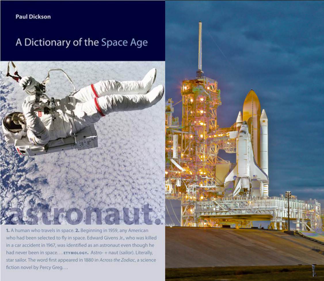
A Dictionary of the Space Age covers most aspects of space flight but is somewhat lacking in detail. Image Credit: John Hopkins University & Alan Walters/awaltersphoto.com
[/caption]
Writing a dictionary is not the same as writing a novel. While it might seem difficult to mess up a dictionary, even one with terminology that is as complicated as that used within the space industry – getting it right can be challenging. For those that follow space flight having such a dictionary can be invaluable. While A Dictionary of the Space Age does meet the basic requirements easily it fails somewhat in terms of its comprehensiveness.
When normal folks, even space enthusiasts watch launches and other space-related events (EVAs, dockings, landings and such) there are so many acronyms and jargon thrown about – that it is extremely hard to follow. With A Dictionary of the Space Age on hand, one can simply thumb through and find out exactly what is being said, making it both easier to follow along and making the endeavor being witnessed far more inclusive. That is as long if you are only looking for the most general of terms. The book is far from complete – but given the complex nature of the topic – this might not have been possible.
Crewed, unmanned, military space efforts and satellites – all have key terms addressed within the pages of this book.
The book is published by The Johns Hopkins University Press and was compiled and written by aerospace expert Paul Dickson. One can purchase the book on the secondary market (Amazon.com) for around $12 (new for around $25). The dictionary also has a Kindle edition which is available for $37.76. Dickson’s previous works on space flight is Sputnik: The Shock of the Century.
Weighing in at 288 pages, the book briefly covers the primary terms used within the space community. In short, if you are interested in learning more about space flight – or wish to do so – this is a good book for you.
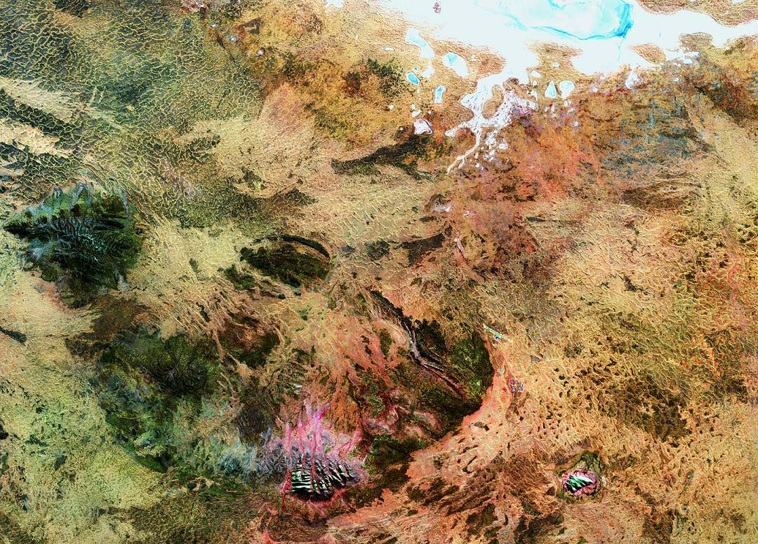
Is this a close-up of what’s in that long forgotten plastic container you found on the back shelf of your refrigerator? No. It’s a Landsat 5 image of some of the most sacred areas in the Australian Outback. Let’s learn what they are…
The big picture is the Amadeus Basin – a sprawling area which covers much of the southern quarter of the Northern Territory and extends about 150 km into Western Australia. At the top of the image, you’ll see the salty Lake Amadeus. But looks here can be deceiving. Most of the time it isn’t a lake by traditional standards… it’s a huge salt deposit that awaits rainfall to become fluid.
The “bumps” at the center of the bottom of the image is Kata Tjuta, with its tallest peak being Mount Olga. Here the Pitjantjatjara Dreamtime legends begin, with nighttime ceremonies not revealed to outsiders. These legends are very beautiful and the formations echo their sentiments. Forty kilometres east of Kata Tjuta (and to the right) is one of the oldest formations on Earth – Ayers Rock – known to the Aboriginals as Uluru.
Ayers Rock by Joe Brimacombe
Formed some 500 million years ago when an ocean still covered the area, Uluru is thought of as the center of creation… not hard to imagine given that its singularity rises 1,142 feet above the desert and the base is an amazing 5 miles around. Ayers Rock consists of cave-covered walls with deep runnels caused by perpetual erosion. Aboriginal legend has it that the blood-red Uluru arose from the ocean in protest of war.
Perhaps a legend we’d all do well to listen to, eh?
Original Image: ESA – Observing Earth. Many thanks to the incomparable Joe Brimacombe for the use of his Ayers Rock image. Be sure to visit Joe’s Ayers Rock Area photo pages!
Frank Culbertson was the Commander of Expedition 3 on the International Space Station when the attacks of 9/11 took place. Photo Credit: NASA.gov
[/caption]
A decade ago, the 9/11 attacks killed close to three thousand people and with the chaos that ensued many more were left wondering what was going on, whether-or-not their loved ones were still alive – or what was coming next. One man in particular was more isolated than the rest of his fellow citizens on that horrific day – he was forced to watch, some 240 miles above the face of the planet – as his nation came under attack.
Frank Culbertson Jr. was the Expedition 3 Commander on the International Space Station when Islamic radicals slammed two planes into the World Trade Center in New York City and a third into the Pentagon in Washington D.C. A fourth hijacked plane, whose target was believed to be the Capitol Building in Washington D.C., was prevented from reaching its destination by passengers. The terrorists on board crashed that plane, United 93, near Shanksville, Pennsylvania.
“I think like most Americans, at first I did not know what was happening – I just knew that it was bad,” said Culbertson referring to the attacks. “It was very painful; it was like seeing a wound in the side of your country, your family and your friends.”
Frank Culbertson was like most Amercans on 9/11 shocked, horrified - and more than anyone else in the world - isolated. Photo Credit: NASA.gov
Culbertson’s crew mates, both Russian, were Soyuz Commander Vladimir Deshurov and Flight Engineer Mikhail Tyurin. They offered all the support they could. Tyurin went so far as to prepare Culbertson’s favorite Borscht dinner that evening. Both of them also gave him time, time to understand and come to terms with what had happened. Russian ground controllers also worked to be supportive of Culbertson during this period. Russia’s TsUP worked to uplink information to Culbertson with whatever information they could when U.S. assets were unable to do so.
Age-wise, the ISS was still a somewhat new enterprise at the time, it had only hosted a crew for about a year – but it was already showing that people from different nations, some of whom had been hostile to one another just a short time before – could work together.
Culbertson initially was not comfortable with expressing his thoughts and feelings about 9/11. With time however; he has shared some of his thoughts regarding that day. Through it all, Culbertson has decided to focus not on anger – but hope.
Culbertson's crew mates, both Russian, did whatever they could to support Culbertson as he watched the events of 9/11 unfold from orbit. Photo Credit: NASA
“I met a veteran at Williamsburg and once he found out what I did – he looked at me and said that what is happening on the International Space Station is one of the best things that we (the U.S.) were doing, we have to work internationally to find peaceful ways to solve our problems. It’s men and women like that, the young people that are in harm’s way working to prevent events like 9/11 from taking place – that are the real heroes.”
Culbertson found even more hope when he talked to the children who were close to the attacks when they occurred.
“I had the privilege of talking to a school that was just a couple blocks away from Ground Zero and meet those kids and teachers in person. They were close to Ground Zero – but they were optimistic about the future – and as they are our future – I think we are in good hands.”