Scientists Have Been Underestimating the Asteroid That Created the Biggest Known Crater on Earth

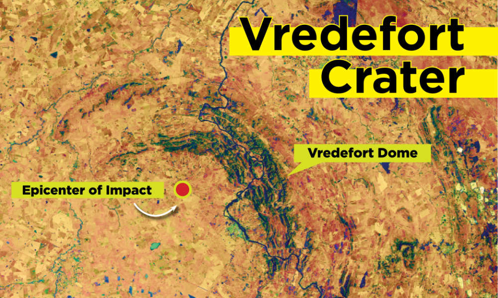
South Africa's Vredefort Crater is Earth's largest impact crater. New Research clarifies the power of the impact and its catastrophic effects. Image Credit: NASA Earth Observatory image by Lauren Dauphin / University of Rochester illustration by Julia Joshpe

Ancient impacts played a powerful role in Earth’s complex history. On other Solar System bodies like the Moon or Mercury, the impact history is preserved on their surfaces because there’s nothing to erase it. But Earth’s geologic activity has erased the evidence of impact craters over time, with some help from erosion.

Earth’s complex history has elevated its status among its Solar System siblings and created a world that’s rippling with life. Ancient giant impacts have played a role in that history, bringing catastrophe and disruption and irrevocably changing the course of events. Deciphering the role these giant impacts played is difficult since the evidence is missing or severely degraded. So how do scientists approach this problem?

One crater at a time.

Continue reading “Scientists Have Been Underestimating the Asteroid That Created the Biggest Known Crater on Earth”
The Tonga Eruption Produced a 90-Meter Tsunami

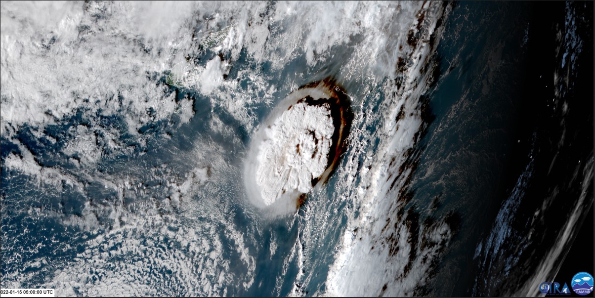
The Tonga Hunga volcanic eruption sent a tsunami across the Pacific. Air pressure disturbances from the tsunami distorted GPS signals. GOES imagery courtesy NOAA,NESDIS.
The Tonga Hunga volcanic eruption as seen by a GOES satellite. Credit: NOAA,NESDIS.

The gigantic underwater Tonga volcano eruption event captured the world’s attention in January of this year. People from around the world marveled at the satellite imagery of this awesome demonstration of nature’s destructive capability. But only now are we learning that the volcano triggered something else – a tsunami wave up to 90m tall, nine times higher than the tsunamis generated by earthquakes. 

Continue reading “The Tonga Eruption Produced a 90-Meter Tsunami”

This is What a Robotic Explorer Might See When it Reaches Europa’s Oceans

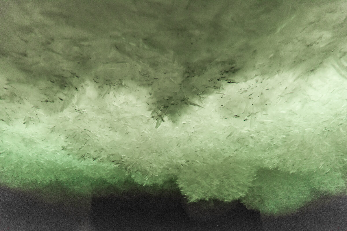
Mounds of snow-like ice under an ice shelf. ©Helen Glazer, 2015 from the project Walking in Antarctica.

For decades, evidence has been mounting that beneath the icy crust of Jupiter’s moon Europa, a vast ocean exists that could possibly host microbial life. As scientists prepare to send the Europa Clipper mission to orbit the Jupiter system, they are trying to learn more about the subsurface ocean and the ice that encompasses the moon.

One way to study Europa is to look at similar environments here on Earth. Scientists say that conditions found under Earth’s Antarctic ice shelf provides an analog to Europa’s subsurface ocean and can help them determine how the moon’s ice shell accretes and grows.

A new study published in the journal Astrobiology looked at a unique phenomenon in the Antarctic ocean called underwater snow. This is where ice floats upwards onto the bottom of the ice shelf and attaches in fluffy-looking mounds. This helps to replenish the ice shelf. The study infers that the same phenomenon is likely true for Jupiter’s moon, and may play a role in building and replenishing its exterior ice shell.

Continue reading “This is What a Robotic Explorer Might See When it Reaches Europa’s Oceans”

Would We Have Continents Without Asteroid Impacts?

continents
An impact between a Mars-sized protoplanet and early Earth is the most widely-accepted origin of the Moon. Did smaller impacts seed the formation of continents? (NASA/JPL-Caltech)

Early Earth was a wild and wooly place. In its first billion years, during a period called the Archean, our planet was still hot from its formation. Essentially, the surface was lava for millions of years. Asteroids bombarded the planet, and the place was still recovering from the impact that formed the Moon. Oceans were beginning to form as the surface solidified and water outgassed from the rock. The earliest atmosphere was actually rock vapor, followed quickly by the growth of a largely hot carbon dioxide and water vapor blanket. Earth was just starting land masses that later became continents. For decades, geologists have asked: what started continental formation?

Continue reading “Would We Have Continents Without Asteroid Impacts?”

Earth’s Magnetic Field Almost Completely Collapsed 550 Million Years Ago

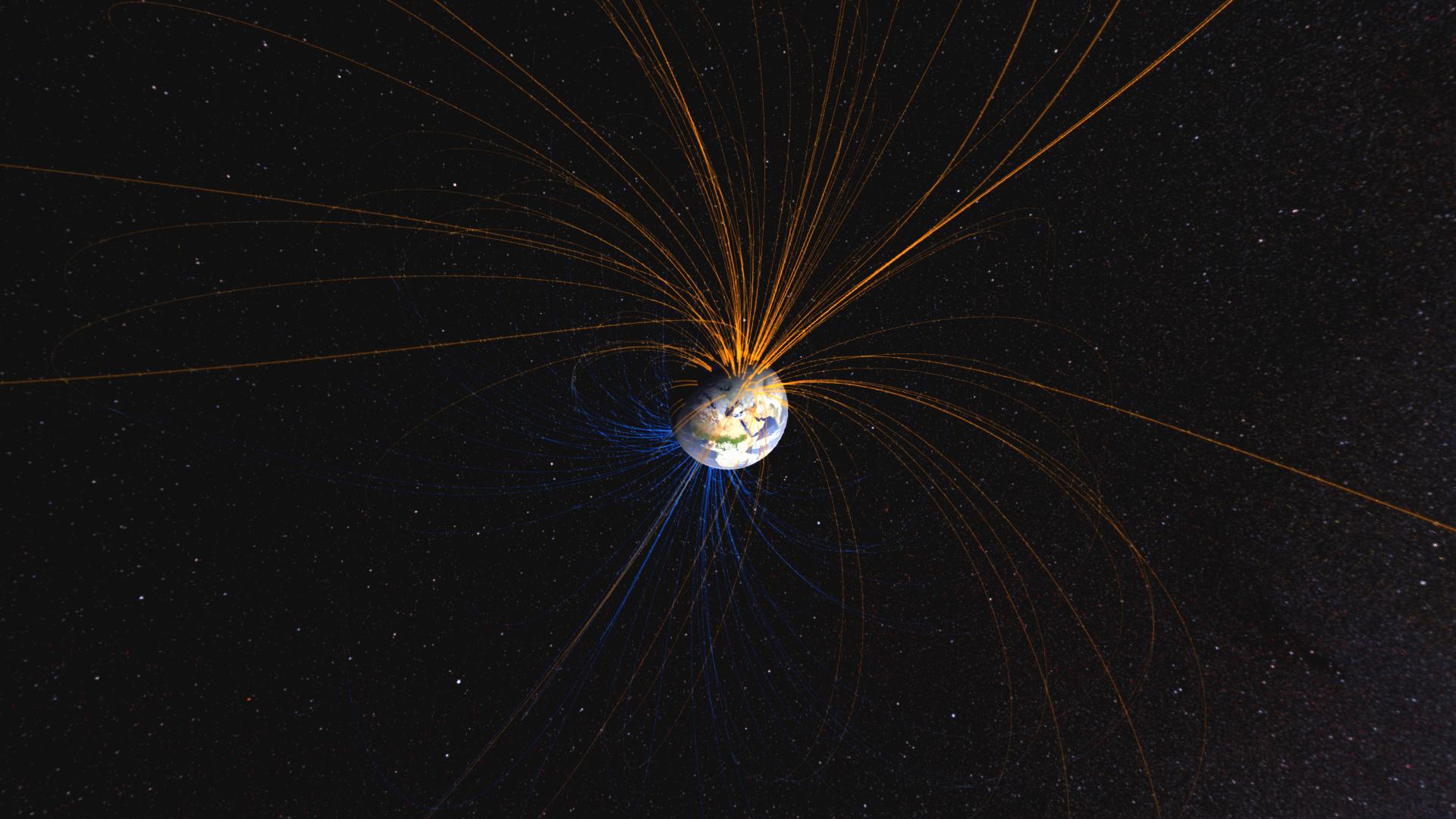
Visual simulation of the Earth's magnetic field. Credit: NASA Goddard Space Flight Center

More than half a billion years ago, Earth experienced an almost-complete collapse of its magnetic field. It began in the early Cambrian period. Then, after a period of about 15 million years, the field began to grow again. The cause of that collapse and the bounceback of the field was a mystery. Then, a group of geologists studied rocks from Oklahoma that were created during that time. Magnetic markers in the rocks’ minerals pointed toward an event that began some 550 million years ago. That was before the introduction of multicellular life on our planet.

Continue reading “Earth’s Magnetic Field Almost Completely Collapsed 550 Million Years Ago”

A New Instrument is Going to the ISS to Study the Climate Impact of Dust in Earth’s Upper Atmosphere

People often seem surprised when they learn that NASA doesn’t just look out to the other planets, stars, and galaxies. It’s also an agency that studies our own home planet—from space! And why not? Earth is part of the solar system, too. So, to that end, there’s a new Earth studies mission called EMIT on its way to the International Space Station. It’s designed to track dust as it moves from one place to another on our planet through through our atmosphere.

The official name of the mission is the Earth Surface Mineral Dust Source Investigation (EMIT, for short). It will use a high-tech imaging spectrometer to study dust around the globe over the next year.

A dust plume stretches over the eastern Mediterranean, shrouding parts of Greece, Turkey, and Cyprus. The June 2020 image has been cropped and enhanced to improve contrast, and lens artifacts have been removed. NASA’s EMIT mission will help scientists better understand how airborne dust affects climate. Credits: NASA
A dust plume stretches over the eastern Mediterranean, shrouding parts of Greece, Turkey, and Cyprus. The June 2020 image has been cropped and enhanced to improve contrast, and lens artifacts have been removed. NASA’s EMIT mission will help scientists better understand how airborne dust affects climate. Credit: NASA
Continue reading “A New Instrument is Going to the ISS to Study the Climate Impact of Dust in Earth’s Upper Atmosphere”

The Rapid Changes We’re Seeing With the Earth’s Magnetic Field Don’t Mean the Poles are About to Flip. This is Normal

An illustration of Earth's magnetic field. Image Credit: ESA/ATG medialab

One of the most interesting discoveries about Earth in the past few decades concerns the Earth’s magnetic poles. Paleomagnetic records show that the poles have flipped places 183 times in the last 83 million years. That’s about every 450,000 years on average, though there were ten million years between flips in at least two cases.

The Earth’s magnetic field is experiencing some rapid changes right now, but scientists say that has no relation to pole flipping.

Continue reading “The Rapid Changes We’re Seeing With the Earth’s Magnetic Field Don’t Mean the Poles are About to Flip. This is Normal”

Antarctica Lost an Ice Shelf, but Gained an Island

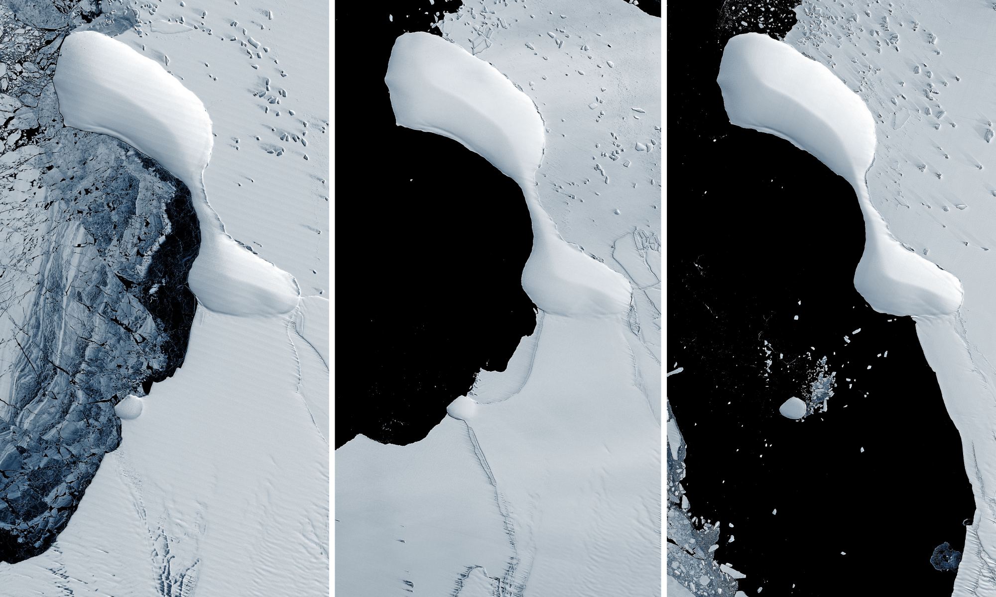
The eastern coast of Antarctica has lost most of the Glenzer and Conger ice shelves, as seen in these satellite images taken between November 15, 1989 - January 9, 2022. Credit: NASA GSFC/UMBC JCET.

Collapsing ice shelves on the eastern coast of Antarctica has revealed something never seen before: a landform that might be an island. But this is not the first newly revealed island off the Antarctic coast. A series of islands have appeared as the ice shelves along the continent’s coastline has disintegrated over the past few years.

Continue reading “Antarctica Lost an Ice Shelf, but Gained an Island”

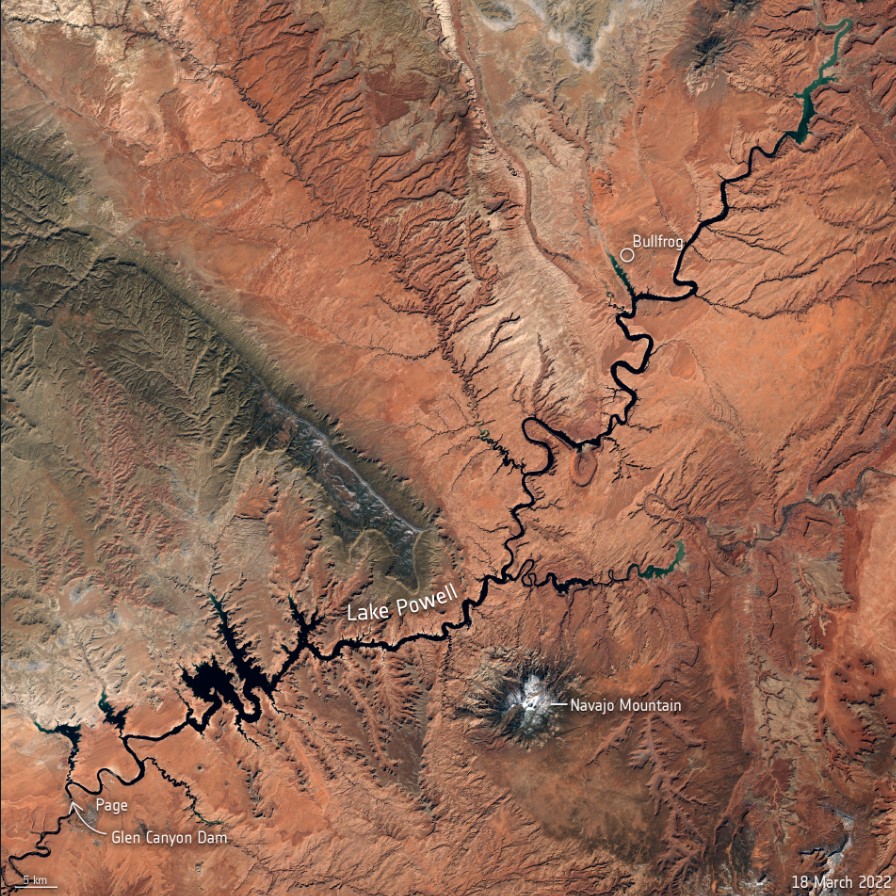
Because of Extreme Drought, Lake Powell is Barely a Lake Anymore

This Copernicus Sentinel-2 image allows us a wider view of Lake Powell and its dwindling water levels amidst the climate crisis. Contains modified Copernicus Sentinel data (2022), processed by ESA.

The two largest reservoirs in the United States are now at their lowest levels since they were first created. After several decades of drought – with the past two years classified as intense drought in the US Southwest — both Lake Powell and Lake Mead are shrinking. Recent satellite images show just how dramatic the changes have been, due to the ongoing the climate crisis..

Continue reading “Because of Extreme Drought, Lake Powell is Barely a Lake Anymore”

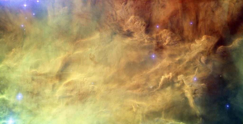
Primordial Helium, Left Over From the Big Bang, is Leaking Out of the Earth

The center of Lagoon Nebula, captured by the Hubble Telescope. Nebulae are the primary sources of helium-3, and the amount of He-3 leaking from the Earth’s core suggests the planet formed inside the solar nebula, according to a new study in the AGU journal Geochemistry, Geophysics, Geosystems. Credit: NASA, ESA

Something ancient and primordial lurks in Earth’s core. Helium 3 (3He) was created in the first minutes after the Big Bang, and some of it found its way through time and space to take up residence in Earth’s deepest regions. How do we know this?

Scientists can measure it as it slowly escapes.

Continue reading “Primordial Helium, Left Over From the Big Bang, is Leaking Out of the Earth”