Countdown to Earth Hour 2008…

earthhour_wideweb__470x4410.thumbnail.jpg

Do you remember last year when Sydney, Australia made the news by turning their lights out for one hour to show their concern about global warming? Besides being concerned about the effects, especially for my children and grandchildren, as an astronomer I support anything which helps reduce light pollution, even if it’s just for an hour. Beyond extinguishing the lights for 60 minutes at 8pm March 29, 2008, there are lots of things you can do to make Earth Hour 2008 an even greater success. Let’s take a look.

2.2 million people and 2100 Sydney businesses turned off their lights for one hour – Earth Hour – March 29, 2008. According to their information, the greenhouse reduction achieved in the Sydney CBD during Earth Hour was sustained for a year, it would be equivalent to taking 48,616 cars off the road for a year. This year many major global cities are joining Earth Hour in 2008, and they’re are turning a symbolic event into a global movement.

Start showing your support by visiting our own Universe Today Earth Hour page and signing up on the UT page. You’ll see your name appear as an Earth Hour / Universe Today participant! Tell a friend. Better still, tell all your friends, and your family, and your workmates. Just email them with a link to this website. We may or may not make an impact, but it won’t be because we didn’t try. You can also organize your own Earth Hour activities as well and you’ll find packets and information on how to involve your community at the Earth Hour Website.

If you think this is going to be big, then you’re right. Created to take a stand against the greatest threat our planet has ever faced, Earth Hour uses the simple action of turning off the lights for one hour to deliver a powerful message about the need for action on global warming. This simple act has captured the hearts and minds of people all over the world. As a result, at 8pm March 29, 2008 millions of people in the world’s major capitol cities like Aalborg, Aarhus, Adelaide, Atlanta, Bangkok, Brisbane, Canberra, Chicago, Christchurch, Copenhagen, Dublin, Manila, Melbourne, Montreal, Odense, Ottawa, Perth, Phoenix, San Francisco, Suva and Lautoka, Sydney, Tel Aviv, Toronto and Vancouver will be participating as well.

At last count, over 172,000 individuals and nearly 12,000 businesses/organizations have agreed to support Earth Hour. Just who in the astronomy world would do that? In the United States alone you’ll find such great organizations Adler Planetarium, Arizona Science Center, Oceanside Photo and Telescope, StarPals, and The Chicago Astronomer just to name a few. You’d be amazed at the number of schools, universities, restaurants, motels, airlines and others that will be participating.

Sign up now… And let the Universe Today voice be heard!

Gravity Waves in the Atmosphere can Energize Tornados (Video)

Gravity waves are global events. Much like the ripples on a massive pond, these large-scale waves can propagate from an atmospheric disturbance over thousands of miles. These waves are maintained by the gravitational force of Earth pulling down and the buoyancy of the atmosphere pushing up. Until now it has been hard to link atmospheric gravity waves with other atmospheric phenomena, but new research suggests that gravity waves passing over storms can spin up highly dangerous and damaging tornados… Suddenly gravity waves become very important and may help to forecast where and when tornados may strike…

In a nutshell, meteorologist Tim Coleman of the National Space Science and Technology Center in Huntsville (Alabama) sums up what gravity waves are:

They are similar to waves on the surface of the ocean, but they roll through the air instead of the water. Gravity is what keeps them going. If you push water up and then it plops back down, it creates waves. It’s the same with air.” – Coleman

A large number of things may cause gravity waves (not to be confused with gravitational waves, the ripples in space-time), including intense disturbances caused by storm systems, a sudden change in jet stream location or wind shear. The strong oscillation will then travel for hundreds or even thousands of miles.

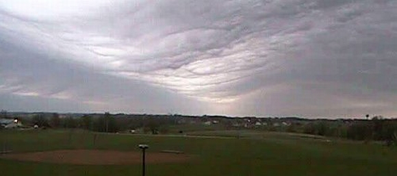
Still from a movie of a gravity wave passing over Tama, Iowa in 2006 (credit: Iowa Environmental Mesonet Webcam)

See a gravity wave in action over Iowa…

Far from gravity waves being a mild curiosity, it seems that they have a large part to play with other atmospheric dynamics down here on the ground.

Tim Coleman and colleagues have found that the passage of gravity waves over the top of storms could intensify or even create tornados. It is all down to the angular momentum of the spinning storm. When storms are large, they slowly rotate. If for some reason they shrink in scale, the spin will increase (imagine an ice-skater spinning on the ice with her arms outstretched, as she brings her arms in, she spins faster). This is the fundamental rule of angular momentum conservation, as the size of a storm contracts, the faster it spins. Ultimately, if the conditions are right, intense tornados can be generated, a huge amount of angular momentum in a tiny volume.

Now gravity waves are believed to have a part to play. As they pass over a storm, the pressure of the overlying gravity wave propagation will compress the storm. As this occurs, a vast amount of angular momentum is forced into a smaller volume. The seeding of baby tornados is therefore possible. Gravity waves also come in sets; one wave will follow another, each periodically compressing the storm, intensifying tornado generation.

So keep your eyes peeled for incoming gravity waves during a storm… tornados may spin to life…

Source: NASA

Plans for a “Doomsday Ark” on the Moon are in the Works

350px-lunar_base_concept_drawing_s78_23252.thumbnail.jpg

Let’s say something terrible happens to your computer, like it crashes or you drop it. All of those movies you bought online are toast, as is your address book and most of your work. It’s always a good idea to have a backup somewhere else, right?

Having a backup of your computer is handy, but having a backup of the entire progress of human civilization is even more practical. If a major catastrophic event like nuclear war or an asteroid strike wipes out most of the humans on the planet, it would be helpful for the survivors to have a record of all the accomplishments we’ve made in the past few thousands of years to help rebuild and repopulate the Earth.

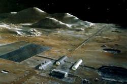
The closest off-world place to store such a structure and ensure its safety would be the Moon. The construction of such a “doomsday ark” was presented last month by William Burrough and Jim Burke at a symposium on “Space Solutions to Earth’s Global Challenges” at the International Space University in Strasbourg, France.

There are already gene banks – stores of plant seeds – around the world, one of which is the Svalbard Global Seed Vault, which officially opened last month. But having a backup inside your computer doesn’t help if you drop it in a lake, so taking such an important operation off the Earth would make it that much more likely to survive any major catastrophes.

The ark would contain hard disks that store the genetic information of humans, plants and animals, as well as information on necessary or helpful processes for survival such as smelting metal, planting crops and building houses. Like the seed vaults, the ark could be expanded to include actual seeds, plants and frozen genetic material, which would aid in the re-population of these species given that a spacecraft could be launched to retrieve them.

After being constructed underneath the surface of the Moon to protect it from the radiation from the Sun and the extreme temperatures of the Moon’s surface, the vault could be set to automatically transmit the information to the Earth in case of disaster. Outposts containing a receiver and supplies necessary for survival would be installed across our planet to aid in rebuilding and the reception of information. The databank would transmit in a variety of different languages to ensure that the survivors could actually read the sent instructions.

To start, the ark would be tended by robots, but a future base on the Moon might allow it to be maintained and improved by human beings (an even better safeguard against humanity being wiped out).The scientists think it would be possible to place such an ark on the Moon before 2020. This basic archive would have a 30-year lifespan, and could be followed up with a more complete archive by the year 2035.

Source: Telegraph.co.uk

Discovery of the Earth’s Inner, Inner Core

coreb_b.thumbnail.jpg

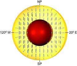
The traditional view of the Earth’s interior has the crust (where we live), the upper and inner mantle, the outer core, and the inner core; wrapped around each other like layers of an onion. But now textbooks will need to be revised. It turns out there’s an inner, inner core.

The core of Earth is known to have an inner core of solid iron about 2,400 km (1,500 miles). Wrapped around that is a fluid outer core that reaches 7,000 km across (4,300 miles). As the solid core rotates inside the fluid core, it generates the magnetic field that helps us navigate, and protects the planet from harmful radiation and the effects of the solar wind.

Geologists from the University of Illinois at Urbana-Chamaign have been probing the interior of the planet, trying to get a better sense of its structure. And that’s harder than it sounds. You can’t just look down through thousands of km of solid rock.

There were using the natural waves that pass through the Earth after earthquakes shake on the surface. The waves are bent and reflected as they pass through the various layers inside the planet.

The team was specifically studying how the waves were affected as they passed through the solid inner core and were surprised to see that it wasn’t a uniform sphere of iron.

Instead, the seismic waves clearly showed that there’s an additional layer at a diameter of 1,180 km (733 miles), which makes this less than half the diameter of the inner core.

This is the Earth’s inner, inner core.

So what is it? Here’s what the lead scientists, Xiaodong Song had to say:

“Our results suggest the outer inner core is composed of iron crystals of a single phase with different degrees of preferred alignment along Earth’s spin axis,” Sun said. “The inner inner core may be composed of a different phase of crystalline iron or have a different pattern of alignment.”

It’s still iron, just not in the same crystalline structure. Perhaps its time to give the layers new names, inner inner core doesn’t quite work for me.

Original Source: University of Illinois News Release

Earth and Moon, As Seen From Mars

This picture was released a couple of days ago, but since it’s so special, it deserves a post on Universe Today. And besides, everyone secretly likes to look at pictures of themselves. And this is a picture of us: it’s the Earth and the moon, as seen from Mars. From the Mars Reconnaissance Orbiter, to be exact, and it was taken by the HiRISE Instrument on board, the High Resolution Imaging Science Experiment. That’s the same camera that gave us the images of the avalanche on Mars, so the capabilities of this instrument are quite spectacular. This image was snapped back in October 2007, from a distance of 142 million kilometers, and if you look closely, you can make out a few features on Earth.

The west coast outline of South America is at lower right on Earth, although the clouds are the dominant features. In fact, the clouds were so bright, compared with the Moon, that they almost completely saturated the filters on the HiRISE camera. The people working on HiRISE say this image required a fair amount of processing to make a such a nice-looking picture. Yes, I agree, we are looking quite nice.

The phase angle is 98 degrees, which means that less than half of the disks of the Earth and Moon have direct illumination from the sun; that’s the reason we only see about half of each object. The scientists working on HiRISE say they would be able to image the Earth and moon when they are fully illuminated, but only when they are on the opposite side of the sun from Mars. However, then the distance would be much greater and the image would show less detail.

At this distance, this HiRISE image has a scale of 142 km/pixel, giving the Earth diameter about 90 pixels and the Moon diameter 24 pixels.

And now, back to the target that HiRISE was originally designed for: Mars. Here’s a very colorful (and false color) image that highlights the different minerals in Nili Fossae on Mars, one of the potential landing sites for the Mars Science Laboratory rover. From the CRISM instrument, the on-board spectrometer, scientists can discern that this area on Mars contains iron and magnesium, minerals that also contain water.
Nili Fossae on Mars.  Image Credit: NASA/JPL/University of Arizona

Original News Source: HiRISE Web page

Solar Variability Most Likely Not the Cause of Global Warming

sun.thumbnail.jpg

The gradual increase in global temperatures is getting harder and harder to pin on the Sun and its energy output variability. The Sun has a variation in how much energy it outputs but this variability is only about one tenth of one percent. The pattern of atmospheric heating since the 1960s is showing an increase with the increase in human activity (industry, transportation, power generation) and neither are showing signs of slowing down…

At the American Association for the Advancement of Science (AAAS) meeting in Boston, many talks are focusing on climate change and the human impact on the Earth. Experts in solar science, climate modeling, and atmospheric science are exploring the issues surrounding what the main culprit behind the rapid rate of change in global temperatures could be. The sole energy input into the Earths atmosphere comes from the Sun; so many scientists have looked toward our star for the answers. The Sun does vary its output of energy (historically, this is obvious during long periods of solar inactivity, such as the Maunder Minimum in the 1600’s where hardly any sunspots were observed on the Sun – this reduction in activity has been linked to the “Little Ice Age” experienced during this time), but generally speaking, the net energy increase or decrease is very small.

The link between solar variability and global warming has taken another blow from analysis of historical samples of sediment containing radioactive carbon-14 and a beryllium isotope. Quantities of carbon-14 and beryllium-10 reflect solar activity as they are greatly affected by solar magnetic field strength. The Sun’s magnetic field is directly related to solar activity (and therefore sunspot population). These radioactive isotopes are created by the impact of cosmic rays in the Earths atmosphere, and should the solar magnetic field be strong (i.e. during periods of high activity), cosmic rays will be blocked, reducing the quantity of isotopes in the sediment.

However, results from this analysis appear inconclusive and no strong link can be found in favour of increased solar activity during periods of atmospheric heating.

Linking any atmospheric phenomenon with solar variability is a difficult task. Attempts to connect monsoons with the 11-year solar cycle for instance have failed in 150 years of trying. It would seem that, for now at least, any connection between increased solar energy output and global warming is tenuous at best.

Casper M. Ammann, climate modeler at the National Center for Atmospheric Research in Boulder, Colorado, points out that global temperatures are rising at a historic rate, and there remains no link between solar variability and global warming. He states that global warming has “nothing to do with changes in solar activity. It’s greenhouse gases. It’s not the sun that is causing this [climate] trend.”

Perhaps the only answer is to drastically cut back our dependence on fossil fuels to slow the rate of carbon dioxide production. Even if the Sun should decide to become inactive, as there appears to be very little relationship between solar output and global warming, we will not be able to escape the greenhouse gases heating up our climate.

Source: Physorg.com

What Would Happen if a Small Black Hole Hit the Earth?

We can all guess what would happen should a massive black hole drift into our solar system… there wouldn’t be much left once the intense gravitational pull consumes the planets and starts sucking away at our Sun. But what if the black hole is small, perhaps a left over remnant from the Big Bang, passing unnoticed through our neighborhood, having no observable impact on local space? What if this small singularity falls in the path of Earths orbit and hits our planet? This strange event has been pondered by theoretical physicists, understanding how a small black hole could be detected as it punches a neat hole though the Earth…

Primordial black holes (PBHs) are a predicted product of the Big Bang. Due to the massive energy generated at the beginning of our Universe, countless black holes are thought to have been created. However, small black holes are not expected to live very long. As black holes are theorized to radiate energy, they will also lose mass (according to Stephen Hawking’s theory, Hawking Radiation), small black holes will therefore fizz out of existence very rapidly. In a well known 1975 publication by Hawking, he estimates the minimum size a black hole must be to survive until present day. The PBH would have to be at least 1012kg (that’s 1,000,000,000,000 kg) in mass when it is created. 1012kg is actually quite small in cosmic standards – Earth has a mass of 6×1024kg – so we are talking about the size of a small mountain.

So, picture the scene. The Earth (any planet for that matter) is happily orbiting the Sun. A small primordial black hole just happens to be passing through our solar system, and across Earths orbit. We are all aware of how a rocky body such as a Near Earth Asteroid would affect the Earth if it hit us, but what would happen if a small Near Earth Black Hole hit us? Theoretical physicists from the Budker Institute of Nuclear Physics in Russia, and the INTEGRAL Science Data Center in Switzerland, have been pondering this same question, and in a new paper they calculate how we might observe the event should it happen (just in case we didn’t know we had hit something!).

PBHs falling into stars or planets have been thought of before. As previously reviewed in the Universe Today, some observations of the planets and stars could be attributed to small black holes getting trapped inside the gravitational well of the body. This might explain the unusual temperatures observed in Saturn and Jupiter, they are hotter than they should be, the extra heat might be produced by interactions with a PBH hiding inside. If trapped within a star, a PBH might take energy from the nuclear reactions in the core, perhaps bringing on a premature supernova. But what if the PBH is travelling very fast and hits the Earth? This is what this research focuses on.

I’d expect some catastrophic, energetic event as a primordial black hole hits the Earth. After all, it’s a black hole! But the results from this paper are a bit of an anti-climax, but cool all the same.

By calculating where the energy from the collision may come from, the researchers can estimate what effect the collision may have. The two main sources of energy will be from the PBH actually hitting Earth material (kinetic) and from black hole radiation. Assuming we have more likelihood of hitting a micro-black hole (i.e. much, much smaller than a black hole from a collapsed star) originating from the beginning of the Universe, it is going to be tiny. Using Hawking’s 1012kg black hole as an example, a black hole of this size will have a radius of 1.5×10⁻¹⁵ meters… that’s approximately the size of a proton!

This may be one tiny black hole, but it packs quite a punch. But is it measurable? PBHs are theorized to zip straight through matter as if it wasn’t there, but it will leave a mark. As the tiny entity flies through the Earth at a supersonic velocity, it will pump out radiation in the form of electrons and positrons. The total energy created by a PBH roughly equals the energy produced by the detonation of one tonne of TNT, but this energy is the total energy it deposits along its path through the Earths diameter, not the energy it produces on impact. So don’t expect a magnificent explosion, we’d be lucky to see a spark as it hits the ground.

Any hopes of detecting such a small black hole impact are slim, as the seismic waves generated would be negligible. In fact, the only evidence of a black hole of this size passing through the planet will be the radiation damage along the microscopic tunnel passing from one side of the Earth to the other. As boldly stated by the Russian/Swiss team:

It creates a long tube of heavily radiative damaged material, which should stay recognizable for geological time.” – Khriplovich, Pomeransky, Produit and Ruban, from the paper: “Can one detect passage of small black hole through the Earth?

As this research focuses on a tiny, primordial black hole, it would be interesting to investigate the effects of a larger black hole would have on impact – perhaps one with the mass of the Earth and the radius of a golf ball…?

Source paper: arXiv

Human Damage to World Oceans Mapped, 40% “Strongly Impacted”

oceanmap_article.thumbnail.jpg

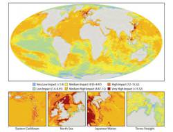
If we needed any more proof that we as a race are damaging the worlds oceans, for the first time, our impact has been mapped by new study to be published in Science. It makes for uncomfortable viewing. Taking 17 known types of human impact on marine ecosystems, this new research suggests that only 4% of the oceans are relatively untouched, whilst 40% are strongly impacted by human activity. The most impacted marine ecosystems include the North Sea, the South and East China Seas, the Caribbean, the Mediterranean, the Red Sea, the Gulf, the Bering Sea, the East coast of North America and in much of the western Pacific.

The new, high-resolution map of predominantly yellow regions and red dots could be mistaken for a global temperature map. However, this map is the first of its kind, mapping damaging human activity in the worlds oceans. At first glance it is obvious that most of the oceans have been affected in some way by the continued onslaught of human activity, with only the Polar Regions holding some of the most pristine and untouched seas. These are about the only portions of the map where the reach of human activity cannot grasp, but as global warming increases, the protective ice-sheets are likely to reveal more sea for humankind to exploit.

This new research was released today at the AAAS Annual Meeting and will be published in the February 15th issue of Science. The scientists behind this study are attending a special three day seminar on “Managing Threats to Marine Ecosystems”. Although this work highlights the concerns about damage to our oceans, it may also aid future efforts to preserve areas of low human impact and will help us identify the worst affected regions.

Whether one is interested in protecting ocean wilderness, assessing which human activities have the greatest impact, or prioritizing which ecosystem types need management intervention, our results provide a strong framework for doing so.” – Kimberly Selkoe of the National Center for Ecological Analysis and Synthesis (NCEAS) in Santa Barbara, CA and the University of Hawaii.

The map was created by dividing the Earths oceans into a grid of 1km×1km squares. The 17 contributing human factors were identified (including fishing, coastal development, fertiliser runoff and pollution from shipping traffic) and the extent at which each grid-point was influenced by each contributing factor was calculated. An “impact score” was then allocated at each location to rate how 20 different types of ecosystem are affected by each factor. It was found that an astonishingly high 41% of the oceans had medium-high to high impact ratings. 0.5% had very high impact ratings, representing 2.2 million square km (850,000 square miles).

Although these results may seem grim, it is the first chance scientists have had to evaluate the worst affected oceans, and many appear upbeat about managing the oceans better, preserving what is left of our pristine seas.

Our results show that when these and other individual impacts are summed up, the big picture looks much worse than I imagine most people expected. It was certainly a surprise to me. […] With targeted efforts to protect the chunks of the ocean that remain relatively pristine, we have a good chance of preserving these areas in good condition.” – Ben Halpern, assistant research scientist at the University of California, Santa Barbara, research leader. “

Source: AAAS, Guardian Online

Could Nitrogen Pollution Give Tropical Flora a Much Needed Boost?

greenplants.thumbnail.jpg

Global warming and subsequent climate change is directly linked with human activity on our planet. The greenhouse effect is amplified by our need for energy, burning fossil fuels and pumping vast quantities of CO2 into our atmosphere. To make things worse, the plants that form the Earth’s “lungs” in the tropics are being destroyed on a massive scale, so less carbon dioxide can be scrubbed from the air. However, it’s not all bad news. Industry and agriculture also generate large amounts of excess nitrogen pollution and scientists now believe that this nitrogen (a main ingredient for fertilizer) may help to increase tropical plant growth by up to 20%…

From our high school classes, we all know that green plants, through photosynthesis, absorb atmospheric carbon dioxide. It is essential for plants to flourish. By far the largest absorbers of carbon dioxide are the tropical rainforests in the Amazon basin, central Africa and southern Asia. They are often referred to as the “lungs” of Earth, as they absorb much of the atmospheric CO2 and provide balance to the carbon budget of our climate. If this resource is removed through wholesale deforestation, more CO2 collects in the atmosphere and global warming is amplified by the increase of this greenhouse gas.

However, help may be at hand. Taking the results from over 100 previously published studies, David LeBauer and Kathleen Treseder from the University of California Irvine, believe they have found a trend that suggests a strong link between nitrogen pollution and increased plant growth in tropical regions. Increased plant growth is a welcomed consequence of human activity, as faster plant growth means more plants to absorb more CO2. Although deforestation is a global catastrophe (much of the ancient forests will never recover and a vast proportion of plant and animal species are now extinct), the new research published in Ecology may influence future climate change models.

We hope our results will improve global change forecasts.” – David LeBauer, UCI graduate student researcher of Earth system science and lead author of the study.

Nitrogen pollution comes in many forms, the most obvious being from agricultural activity (fertilizer) polluting water supplies and industrial burning emitting nitrogen into the air. What’s more, nitrogen pollution is on the increase, especially in developing countries.

Nitrogen pollution has often been ignored as a possible growth agent in the tropics, as other fertilizing elements are in short supply (typically, if one element is low, no matter how high the other element is, it will have little or no effect on plant growth). Phosphorus for example, is low in tropical regions, but according to the new research, this doesn’t seem to factor and plant growth is increased by 20% regardless.

LeBauer adds: “What is clear is that we need to consider how nitrogen pollution interacts with carbon dioxide pollution. Our study is a step toward understanding the far-reaching effects of nitrogen pollution and how it may change our climate…” It may only be a step, but at least it’s a positive one.

Source: Physorg.com

Earth’s climate will slip past “tipping point” within 100 years

glacier_greenland_or.thumbnail.jpg

Nine key geographical factors have been highlighted as Earth’s critical climate controllers most at risk of slipping past their “tipping points”. This means that once damage reaches a certain point, there can be no recovery; the damage will continue in a downward spiral, amplifying global warming and environmental damage on historic scales. And as if climate news couldn’t get any worse, one such tipping point is only a year away… 

You can’t move these days for articles about climate change, global warming and environmental disasters. All this talk about impending doom and gloom can often lull you into a detached reverie thinking “what the hell can I do about it anyway?” Although sometimes the outlook seems hopeless, scientists are stepping up a gear to understand what is happening and why humans are having such an impact on our world. In the quest to understand the effects we are having on the planet, new research has drawn up a list of nine key factors and processes likely to change the Earth’s climate most dramatically. It is hoped that once we understand how these processes work, and how long we have until the point of no return, action could be taken to allow the climate to heal.

Prof. Tim Lenton from the University of East Anglia, UK, has identified when the tipping points are likely to occur for the nine key geological factors, and the next one is most likely going to be the collapse of the Indian summer monsoon, which is variable at best. The list is as follows (plus predicted time to tipping point):

  • Arctic sea-ice melt (approx 10 years)
  • Greenland ice sheet decay (more than 300 years)
  • West Antarctic ice sheet decay (more than 300 years)
  • Atlantic thermohaline circulation collapse (approx 100 years)
  • El Nino Southern Oscillation increase (approx 100 years)
  • Indian summer monsoon collapse (approx 1 year)
  • Sahara/Sahel greening and West African monsoon disruption (approx 10 years)
  • Amazon rainforest dieback (approx 50 years)
  • Boreal Forest dieback (approx 50 years)

Many of the factors seem obvious. The melting of the Arctic ice for instance will cause a global rise in sea levels and a loss of ice cover causing Earth’s albedo to decrease (reflectivity decreases), amplifying the greenhouse effect. Also, El Nino in the South Pacific will occur more often, causing rapid and extreme changes in the large-scale weather structure; hurricanes, flooding, droughts and unseasonal shifts in the jet stream will become more and more common.

Some of the factors are perhaps less obvious. For instance, the collapse of the Atlantic thermohaline circulation would have a counter-intuitive effect on the north Atlantic, actually cooling the waters around Europe, North America and the Arctic. The thermohaline drives the circulation of the oceans, so should the Atlantic thermohaline collapse, water from the equator will stop drifting north, providing the warmth at such high latitudes. This effect is unlikely to slow the melting of the Arctic ice-sheets, but it will have devastating effects on biodiversity in the region.

Society must not be lulled into a false sense of security by smooth projections of global change […] Our findings suggest that a variety of tipping elements could reach their critical point within this century under human-induced climate change. The greatest threats are tipping of the Arctic sea-ice and the Greenland ice sheet, and at least five other elements could surprise us by exhibiting a nearby tipping point.” – Prof Lenton

Although worrying, many of the tipping point projections could be averted should strong action be taken by the international community and individuals alike – after all, we can all contribute in some way.

Source: Telegraph.co.uk