What Is an Earthquake?

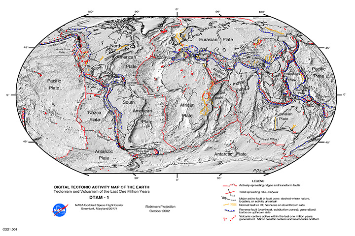
The "Global Tectonic and Volcanic Activity of the Last One Million Years" map. Credit: NASA/DTAM

For people who live on or near an active fault line – such as the San Andreas Fault in California, the Median Tectonic Line in Japan, or the Sunda Megathrust of southeast Asia – earthquakes are a regular part of life. Oftentimes, they can take the form of minor tremors that come and go without causing much damage.

But at other times, they are cataclysmic, causing widespread destruction and death tolls in the thousands or more. But what exactly is an earthquake? What geological forces lead to this destructive force? Where do they typically happen, and how many different types are there? And most importantly, how can we be better prepared for them?

Definition:

An earthquake is defined as a perceptible tremor in the surface of the Earth, which is caused by seismic waves resulting from the sudden release of energy in the Earth’s crust. Sometimes, they are detected because of the transfer of this energy to structures, causing noticeable shaking and noise. At other times, they can be violent enough to throw people and level entire cities.
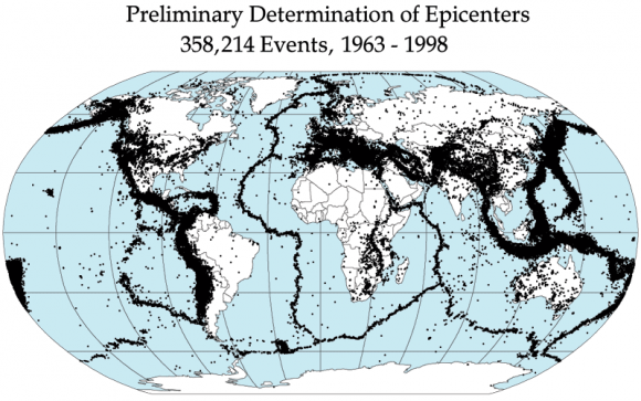
Global earthquake epicenters, 1963–1998. Credit: NASA/DTAM

Generally, the term is used to describe any seismic event that generates seismic waves. An earthquake’s point of initial rupture is called its focus or hypocenter, while the point on the Earth directly above it (i.e. the most immediately-effected area) is called the epicenter.

Causes:

The structure of the Earth’s crust, which is divided into several “tectonic plates”, is responsible for most earthquakes. These plates are constantly in motion due to convection in the Earth’s semi-viscous upper mantle. Over time, these plates will separate and crash into each other, creating visible boundaries called faults.

When plates collide, they remain locked until enough pressure builds that one of them is forced under the other (a process known as subduction). This process occurs over the course of millions of years, and occasionally results in a serious release of energy, frictional heating and cracking along the fault lines (aka. an earthquake).

The energy waves that result are divided into two categories  – surface waves and body waves. Surface waves are so-named because they are the energy that reaches the surface of the Earth, while body waves refer to the energy that remains within the planet’s interior.

The Earth's Tectonic Plates. Credit: msnucleus.org
Map of the Earth’s Tectonic Plates. Credit: msnucleus.org

It is estimated that only 10% or less of an earthquake’s total energy is radiated as seismic energy, while the rest is used to power the fracture growth or is converted into friction heat. However, what reaches the surface triggers all of the effects that we humans associate with earthquakes – i.e. tremors that vary in duration and intensity.

Occasionally, earthquakes can happen away from fault lines. These are due to some plate boundaries being located in regions of continental lithosphere, where deformation is spread out over a much larger area than the plate boundary. Under these conditions, earthquakes are related to strains developed within the broader zone of deformation.

Earthquakes within a plate (called “intraplate earthquakes”) can also happen as a result of internal stress fields, which are caused by interaction with neighboring plates, as well as sedimentary loading or unloading.

Aside from naturally occurring earthquakes (aka. tectonic earthquakes) that occur along tectonic plate lines (fault lines), there are also those that fall under the heading of “human-made earthquakes”. These are all the result of human activity, which is most often the result of nuclear testing.

A 23 kiloton tower shot called BADGER, fired on April 18, 1953 at the Nevada Test Site, as part of the Operation Upshot–Knothole nuclear test series. Credit: NNSA
Earthquakes can also be caused by human-made factors, such as nuclear testing. Credit: NNSA

This type of earthquake can been felt all from considerable distance after the detonation of a nuclear weapon. There is very little actual data that is readily available on this type of earthquake, but, compared to tectonic activity, it can be easily predicted and controlled.

Measurements:

Scientists measure earthquakes using seismometers, which measures sound waves through the Earth’s crust. There is also a method of measuring the intensity of an earthquake. It is known as the Richter Scale, which grades earthquakes from 1 to 10 based on their intensity.

Although there is no upper limit to the scale, most people set ten as the upper limit because no earthquakes equal to or greater than ten have been recorded. Scientist hypothesize that level 10 earthquakes were probably more common in prehistoric times, especially as the result of meteor impacts.

Effects of Earthquakes:

Earthquakes can happen on land or at sea, and can therefore trigger other natural disasters. In the case of those that take place on land, displacement of the ground is often the result, which can cause landslides or even volcanoes. When they take place at sea, the displacement of the seabed often results, causing a tsunami.
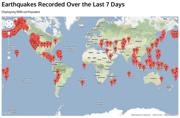
Map of major earthquakes around the world. Credit: USGS / Google Maps / AJAX / SODA
Map of earthquakes around the world in a seven day period. Credit: USGS / Google Maps / AJAX / SODA

Even though major earthquakes do not happen that often, they can cause substantial damage. In addition to the aforementioned natural disasters they can cause, earthquakes can also trigger fires when gas or electrical lines are damaged and floods when dams are destroyed.

Some of the most devastating earthquakes in history include the 1556 Shaanxi earthquake, which occurred on January 1556 in China. This quake resulted in widespread destruction of housing in the region – most of the housing being dwellings carved directly out of the silt stone mountain – and led to over 830,000 deaths.

The 1976 Tangshan earthquake, which took place in north-eastern China, was the deadliest of the 20th century, leading to he deaths of between 240,000 and 655,000 people. The 1960 Chilean earthquake is the largest earthquake that has been measured on a seismograph, reaching 9.5 magnitude on May 22nd, 1960.

And then there was the 2004 Indian Ocean earthquake, a seismic event that also triggered a massive tsunami that caused devastation throughout southeast Asia. This quake reached 9.1 – 9.3 on the Richter Scale, struck coastal communities with waves measuring up to 30 meters (100 ft) high, and caused the deaths of 230,000 people in 14 countries.
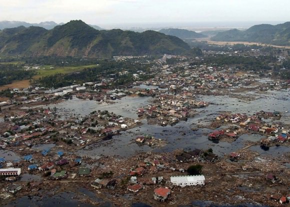
 A village near the coast of Sumatra that was devastated by the 2004 Tsunami. Credit: US Navy
A village near the coast of Sumatra that was devastated by the 2004 Tsunami. Credit: Wikipedia Commons/US Navy

Warning Systems:

More than 3 million earthquakes occur each year, which works out to about 8,000 earthquakes each day. Most of these occur in specific regions, mainly because they usually happen along the borders of tectonic plates. Despite being difficult to predict (except where human agency is the cause) some early warning methods have been devised.

For instance, using seismological data obtained in well-understood fault regions, earthquakes can be reasonably predicted weeks or months in advance. Regional notifications are also used whenever earthquakes are in progress, but before the shocks have struck, allowing people time to seek shelter in time.

Much like volcanoes, tornadoes, and debris flows, earthquakes are a force of nature that is not to be taken lightly. While they are a regular feature of our planet’s geological activity, they have had a considerable impact on human societies. And just like the eruption that buried Pompeii or the Great Flood, they are remembered long after they strike!

We have written many interesting articles about earthquakes here at Universe Today. Here’s Famous Earthquakes, What Causes Earthquakes?, What are Earthquake Fault Lines?, What are the Different Types of Earthquakes? and The Sun Doesn’t Cause Earthquakes,

For more information, you should check out earthquakes and how earthquakes work.

Astronomy Cast has an episode on the subject – Episode 51: Earth

Sources:

Antares ‘Return to Flight’ Blastoff Soars to Stellar Success

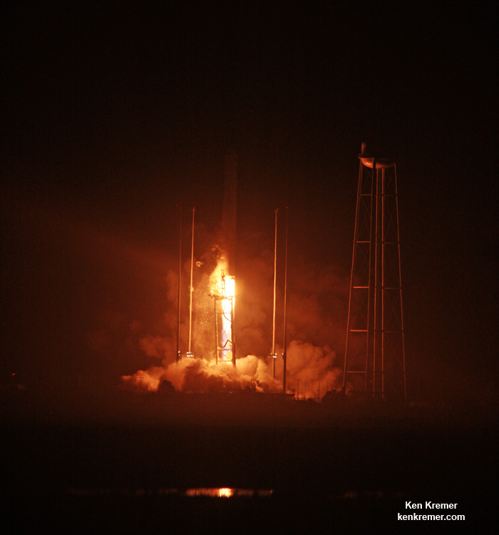
The Orbital ATK Antares rocket topped with the Cygnus cargo spacecraft launches from Pad-0A, Monday, Oct. 17, 2016 at NASA’s Wallops Flight Facility in Virginia. Orbital ATK’s sixth contracted cargo resupply mission with NASA to the International Space Station. Credit: Ken Kremer/kenkremer

NASA WALLOPS FLIGHT FACILITY, VA – The ‘Return to Flight’ blastoff of Orbital ATK’s upgraded Antares rocket soared to a stellar success this evening, Oct. 17, on a space station bound mission to stock the orbiting outpost with two and a half tons of science and supplies.

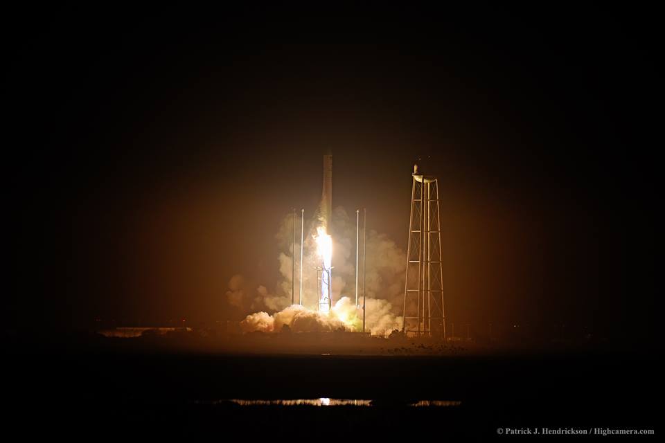
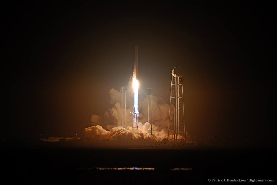
The re-engined Orbital ATK Antares/Cygnus OA-5 mission lifted off at 7:45 p.m. EDT, tonight from the Mid-Atlantic Regional Spaceport pad 0A at NASA’s Wallops Flight Facility on Virginia’s picturesque Eastern shore spewing about 1.2 million pounds of liftoff thrust and brilliantly lighting up the evening skies in every direction.

Sporting a pair of more powerful new RD-181 engines, Antares roared off the launch pad somewhat more swiftly than the previous launches and consequently reached its preliminary orbit about one minute earlier.

Cygnus separated from the second stage as planned about 9 minutes after liftoff. The launch marked the first nighttime liftoff of Antares.

“It’s great to see launches to the International Space Station happening again from the Virginia coast – and it shows what can be accomplish with a close partnership of federal and state agencies, along with the U.S. industry, all working together,” said NASA Administrator Charles Bolden.

“I am incredibly proud of what you have all done,” said Bolden in post launch remarks to the launch team at Wallops Launch Control Center. “Thank you for all your hard work.”

Antares launch on Oct. 17, 2016 from NASA's Wallops Flight Facility in Virginia. Credit: © Patrick J. Hendrickson / Highcamera.com
Antares launch on Oct. 17, 2016 from NASA’s Wallops Flight Facility in Virginia. Credit: © Patrick J. Hendrickson / Highcamera.com

This was the first Antares launch in two years following the rockets catastrophic failure just moments after liftoff on Oct. 28, 2014, which doomed the Orb-3 resupply mission to the space station – as witnessed by this author.

The weather was absolutely perfect at 100% GO by launch time and consequently was visible to millions of East Coast residents from the Carolinas to Maine as well as inland regions.

Visibility was aided by cloudless evening skies that afforded a spectacular long distance view of the engine firings for both the first and second stages, as the rocket accelerated to orbit in a southeastwardly direction before arcing over towards the African continent.

The power producing and life giving solar arrays were deployed and unfurled about two hours after liftoff, finished at about 9:40 p.m.

Cygnus is loaded with over 5,100 pounds of science investigations, food, supplies and hardware for the space station and its crew.

Antares launch on Oct. 17, 2016 from NASA's Wallops Flight Facility in Virginia. Credit: © Patrick J. Hendrickson / Highcamera.com
Antares launch on Oct. 17, 2016 from NASA’s Wallops Flight Facility in Virginia. Credit: © Patrick J. Hendrickson / Highcamera.com

After Cygnus arrives at the ISS on Sunday, Oct. 23, Expedition 49 Flight Engineers Takuya Onishi of the Japan Aerospace Exploration Agency and Kate Rubins of NASA will grapple the spacecraft with the space station’s 57 foot long Canadian-built robotic arm. It will take hold of the Cygnus,

Ground controllers will then command the station’s arm to rotate and install it on the bottom of the station’s earth facing Unity module.

The Cygnus spacecraft will spend about five weeks attached to the space station. Cygnus will remain at the space station until November, when the spacecraft will depart the station and begin a fire experiment dubbed Saffire-II.

The 14 story tall commercial Antares rocket launched for the first time in the upgraded 230 configuration – powered by a pair of the new Russian-built RD-181 first stage engines.

For the OA-5 mission, the Cygnus advanced maneuvering spacecraft was loaded with approximately 2,425 kg (5,346 lb.) of supplies and science experiments for the International Space Station (ISS). The cargo was packed inside 56 cargo bags of multiple sizes.

The experiments will support dozens of new and existing investigations as the space station crews of Expeditions 49 and 50 contribute to about 250 science and research studies.

Among the science payloads aboard the Cygnus OA-5 mission is the Saffire II payload experiment to study combustion behavior in microgravity. Data from this exp,eriment will be downloaded via telemetry. In addition, a NanoRack deployer will release Spire Cubesats used for weather forecasting. These secondary payload operations will be conducted after Cygnus departs the space station.

Here is the Cygnus payload manifest:

Payloads:
• Spacecraft Fire Experiment-II (Saffire-II)
• Fast Neuron Spectrometer
• ACM and Experiment Tray
• SLMMD
Cargo:
• ISS Experiment Hardware
• EVA Equipment– EMU Repair Kit– EVA Supplies
• Emergency Equipment
• Photo/TV and Computer Resources– Computer – iPad Air 2
– Laptop – T61P and Connectors – Camera – Nikon D4
• ISS Hardware and Spare ORUs – Cupola Scratch Panes
– Water ORU
• Food, Crew Supplies and Crew Provisions
• Flight Crew Equipment
• Cargo Environment SensorsAdditional payload details can be found at www.nasa.gov/iss-science.

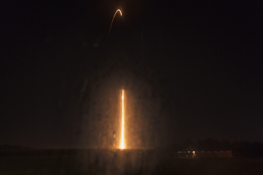
Streak shot of Orbital ATK Antares rocket carrying Cygnus supply ship soars to orbit on Oct. 17, 2016  from Pad-0A at NASA’s Wallops Flight Facility in Virginia.  Credit: Ken Kremer/kenkremer
Streak shot of Orbital ATK Antares rocket carrying Cygnus supply ship soars to orbit on Oct. 17, 2016 from Pad-0A at NASA’s Wallops Flight Facility in Virginia. Credit: Ken Kremer/kenkremer

The Cygnus spacecraft for the OA-5 mission is named the S.S. Alan G. Poindexter in honor of former astronaut and Naval Aviator Captain Alan Poindexter.

Under the Commercial Resupply Services (CRS) contract with NASA, Orbital ATK will deliver approximately 28,700 kilograms of cargo to the space station. OA-5 is the sixth of these missions.

Watch for Ken’s continuing Antares/Cygnus mission and launch reporting. He is reporting from on site at NASA’s Wallops Flight Facility, VA during the launch campaign.

Stay tuned here for Ken’s continuing Earth and Planetary science and human spaceflight news.

Ken Kremer

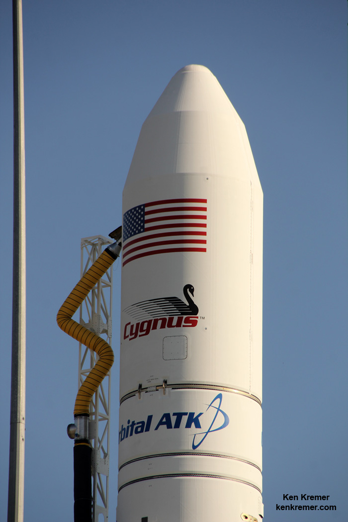
Cygnus cargo spacecraft atop Orbital ATK Antares rocket on Pad-0A prior to blastoff on Oct. 17, 2016 from NASA’s Wallops Flight Facility in Virginia on Orbital ATK’s sixth contracted cargo resupply mission with NASA to the International Space Station. Credit: Ken Kremer/kenkremer

The Orbital ATK Antares rocket, with the Cygnus OA-5 spacecraft onboard, is raised into the vertical position on launch Pad-0A for planned launch on Oct. 17, 2016, at NASA's Wallops Flight Facility in Virginia. Credit: Ken Kremer/kenkremer
The Orbital ATK Antares rocket, with the Cygnus OA-5 spacecraft onboard, is raised into the vertical position on launch Pad-0A for planned launch on Oct. 17, 2016, at NASA’s Wallops Flight Facility in Virginia. Credit: Ken Kremer/kenkremer
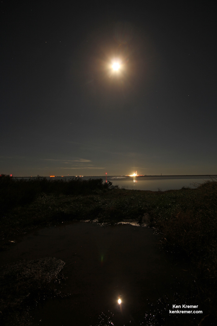
2 Moons and Antares on the launch pad on the evening of Oct. 15, 2016 at NASA's Wallops Flight Facility in Virginia in this water reflection shot.  Liftoff of the OA-5 mission to the ISS is planned for Oct. 17, 2016. Credit: Ken Kremer/kenkremer
2 Moons and Antares on the launch pad on the evening of Oct. 15, 2016 at NASA’s Wallops Flight Facility in Virginia in this water reflection shot. Liftoff of the OA-5 mission to the ISS is planned for Oct. 17, 2016. Credit: Ken Kremer/kenkremer

Antares Return to Flight Set for Magnificent Monday Night Launch – Watch Live

The Orbital ATK Antares rocket, with the Cygnus OA-5 spacecraft onboard, is raised into the vertical position on launch Pad-0A for planned launch on Oct. 17, 2016, at NASA's Wallops Flight Facility in Virginia. Credit: Ken Kremer/kenkremer
The Orbital ATK Antares rocket, with the Cygnus OA-5 spacecraft onboard, is raised into the vertical position on launch Pad-0A for planned launch on Oct. 17, 2016, at NASA’s Wallops Flight Facility in Virginia. Credit: Ken Kremer/kenkremer

NASA WALLOPS FLIGHT FACILITY, VA – The ‘Return to Flight’ blastoff of Orbital ATK’s upgraded Antares rocket will have to wait one more day to come to fruition with a magnificent Monday night launch – after a technical scrub was called this afternoon, Oct. 16, at NASA’s Virginia launch base due to a faulty cable.

The launch potentially offers a thrilling skyshow to millions of US East Coast spectators if all goes well.

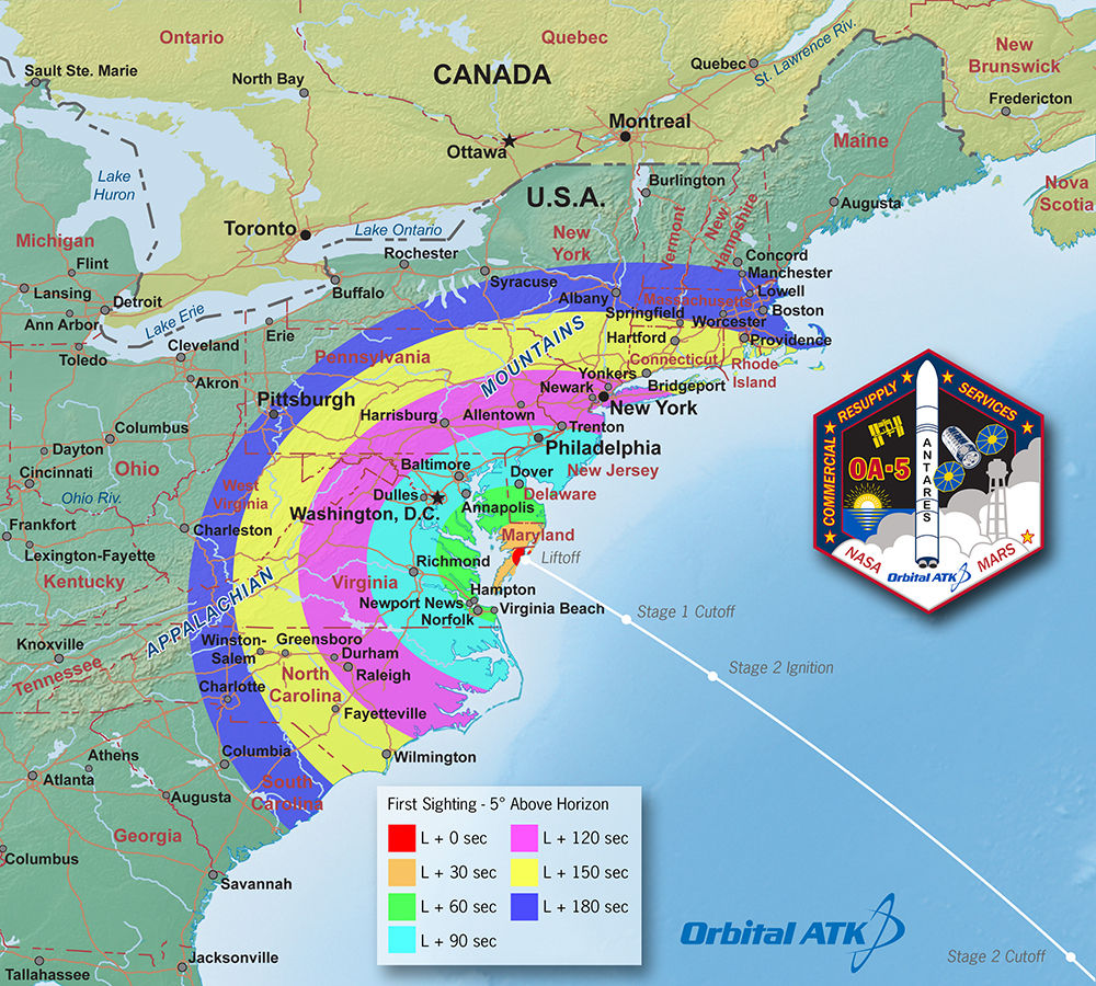
Antares Launch Viewing Map. This “first-sight” map indicates potential to see Orbital ATK’s Antares rocket in the minutes following its launch on the OA-5 mission to the ISS on October 16, 2016. Credit: Orbital ATK

Despite picture perfect Fall weather, technical gremlins intervened to halt Sunday nights planned commercial cargo mission for NASA carrying 2.5 tons of science and supplies bound for the International Space Station (ISS).

The launch of the Orbital ATK CRS-5 mission is now scheduled for October 17 at 7:40 p.m. EDT, from the Mid-Atlantic Regional Spaceport pad 0A at NASA’s Wallops Flight Facility on Virginia’s picturesque Eastern shore.

You can watch the launch live on NASA TV as well as the agency’s website beginning at 6:30 p.m. EDT Oct 17.

Mondays liftoff is slated to take place approximately 23 minutes earlier then Sunday’s hoped for time of 8:03 p.m. EDT in order to match the moment when the orbital plane of the station passes on NASA Wallops.

The weather outlook on Monday remains extremely favorable with a 95 percent chance of acceptable conditions at launch time.

A nearly full moon has risen over Antares the past few days at the launch pad.

2 Moons and Antares on the launch pad on the evening of Oct. 15, 2016 at NASA's Wallops Flight Facility in Virginia in this water reflection shot.  Liftoff of the OA-5 mission to the ISS is planned for Oct. 17, 2016. Credit: Ken Kremer/kenkremer
2 Moons and Antares on the launch pad on the evening of Oct. 15, 2016 at NASA’s Wallops Flight Facility in Virginia in this water reflection shot. Liftoff of the OA-5 mission to the ISS is planned for Oct. 17, 2016. Credit: Ken Kremer/kenkremer

Announcement of the launch scrub of the mission – also known as OA-5 – came just as the six hour countdown was set to begin after engineers discovered the bad cable.

“Today’s launch of Orbital ATK’s Antares rocket is postponed 24 hours due to a ground support equipment (GSE) cable that did not perform as expected during the pre-launch check out,” officials at NASA Wallops said.

The faulty cable was a component of the rocket’s hold down system at the pad, Orbital ATK officials told Universe Today after the scrub was announced.

Technicians have spares on hand and are working now to replace the cable in time to permit a Monday evening launch.

“We have spares on hand and rework procedures are in process. The Antares and Cygnus teams are not currently working any technical issues with the rocket or the spacecraft.”

Besides the cable the rocket is apparently in perfect shape.

“The Antares and Cygnus teams are not currently working any technical issues with the rocket or the spacecraft.”

Antares launches have been on hold for two years after it was grounded following its catastrophic failure just moments after liftoff on Oct. 28, 2014 that doomed the Orb-3 resupply mission to the space station – as witnessed by this author.

Orbital ATK’s Antares commercial rocket had to be overhauled with the completely new RD-181 first stage engines- fueled by LOX/kerosene – following the destruction of the Antares rocket and Cygnus supply ship two years ago.

The 14 story tall commercial Antares rocket also will launch for the first time in the upgraded 230 configuration – powered by new Russian-built first stage engines designed and manufactured by Energomesh.

The 133-foot-tall (40-meter) Antares was rolled out to pad 0A on Thursday, Oct. 13 – three days prior to Sunday’s intended launch date. It was raised to the vertical launch position on Friday.

The Orbital ATK Antares rocket, with the Cygnus OA-5 spacecraft onboard, is raised into the vertical position on launch Pad-0A for planned launch on Oct. 17, 2016, at NASA's Wallops Flight Facility in Virginia. Credit: Ken Kremer/kenkremer
The Orbital ATK Antares rocket, with the Cygnus OA-5 spacecraft onboard, is raised into the vertical position on launch Pad-0A for planned launch on Oct. 17, 2016, at NASA’s Wallops Flight Facility in Virginia. Credit: Ken Kremer/kenkremer

The two stage Antares will carry the Orbital OA-5 Cygnus cargo freighter to orbit on a flight bound for the ISS and its multinational crew of astronauts and cosmonauts.

The launch marks the first nighttime liftoff of the Antares – and it could be visible up and down the eastern seaboard if weather and atmospheric conditions cooperate to provide a spectacular viewing opportunity to the most populated region in North America.

The Cygnus spacecraft for the OA-5 mission is named the S.S. Alan G. Poindexter in honor of former astronaut and Naval Aviator Captain Alan Poindexter.

Under the Commercial Resupply Services (CRS) contract with NASA, Orbital ATK will deliver approximately 28,700 kilograms of cargo to the space station. OA-5 is the sixth of these missions.

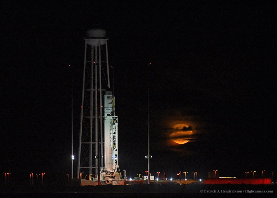
Antares and the Moon at the pad at NASA's Wallops Flight Facility in Virginia as seen from a boat off shore in the Atlantic Ocean on Oct. 15, 2016. Credit: © Patrick J. Hendrickson / Highcamera.com
Antares and the Moon at the pad at NASA’s Wallops Flight Facility in Virginia as seen from a boat off shore in the Atlantic Ocean on Oct. 15, 2016. Credit: © Patrick J. Hendrickson / Highcamera.com

Watch for Ken’s continuing Antares/Cygnus mission and launch reporting. He will be reporting from on site at NASA’s Wallops Flight Facility, VA during the launch campaign.

Stay tuned here for Ken’s continuing Earth and Planetary science and human spaceflight news.

Ken Kremer

What is the Wettest Place on Earth?

Countries by average annual precipitation. Credit: Wikipedia Commons/Atila Kagan

Those who live along the “wet coast” – which is what people living in Puget Sound or the lower mainland of British Columbia and Vancouver Island affectionately call their home – might think that they live in the wettest place on Earth. Then again, people living in the Amazon rain forest might think that there lush and beautiful home is the dampest place in the world.

But in truth, all these places come up dry (pun intended!) compared to the one place that has held the title for wettest point on Earth many times in its history. And that place is none other than Mawsynram, India, which experiences an annual average rainfall of 12 meters. And yet, this curious region in northwestern part of the Indian subcontinent is an exercise in extremes, either drowning in rainwater, or starving for it.

Annual Rainfall:

When it comes to describing locations on planet Earth in terms of “wet”, some clarifications are needed. What we are talking about is average annual precipitation – i.e. rainfall, snow, drizzle, fog, etc. – measured in mm (or inches). This is necessary because otherwise, the “wettest” place on Earth would be the Mariana Trench, which has over 10,000 meters (36,000 feet) of water on top of it.

Cherrapunji, one of the wettest places on Earth. Credit: Public Domain

Also, based on rainfall. the wettest place on Earth has been known to change from time to time. In recent years, that title has gone to the town of Mawsynram, a village located in the East Khasi Hills district of northeastern, India. With an average annual rainfall of 11,872 millimetres (467.4 in), it is arguably the wettest place on Earth.

However, it is often in competition with the neighboring town of Cherrapunjee, which is located just 15 km (9.3 mi) to the west of Mawsynram in the East Khasi Hills district in northeastern India. The city’s yearly rainfall average stands at 11,777 millimetres (463.7 in), so it too has held the title.

The reason for these town experiencing so much precipitation has to do with the local climate. Situated within a subtropical highland climate zone, it experiences a lengthy and powerful monsoon season. In once instance, the monsoon season lasted for 2 years straight with no reported break in the rain!

Surprisingly, the high rainfall is a result of the region’s elevation and not the monsoon season alone. Huge amounts of warm air condense and fall as rain when they encounter the Khasi Hills. The topography of the region forces the very moist clouds up and down, forcing them to empty their accumulated water over the region.

Seven Sisters' falls, located in the East Khasi Hills district. Credit: Wikipedia Commons/Rishav999
Seven Sisters’ falls, located in the East Khasi Hills district. Credit: Wikipedia Commons/Rishav999

Other Locations:

Beyond northeastern India, there are several other locations on the planet that experience over 10 meters (32.8 feet) of annual precipitation. For instance, the town of Tutunendo, Colombia, experiences an average of 11,770 mm (463.38 in) of annual rainfall. The area actually experiences two rainy seasons a year, so precipitation is pretty much the norm.

Next up, there is Mount Waialeale, a shield volcano located on the island of Kaua’i on the Hawaiian Islands. As the the second highest point on the island, its name literally means “rippling water” (or “overflowing water”), and for good reason! This mountain has had an average of 11,500 mm (452 in) of rainfall since 1912.

However, in 1982, its summit experienced 17,300 mm (683 in), making it the wettest place on Earth in that year. And between 1978-2007, Big Bog – a spot in Haleakala National Park on the island of Maui, Hawaii – experienced an average of 10,300 mm (404 in) of rainfall, putting it in the top ten.

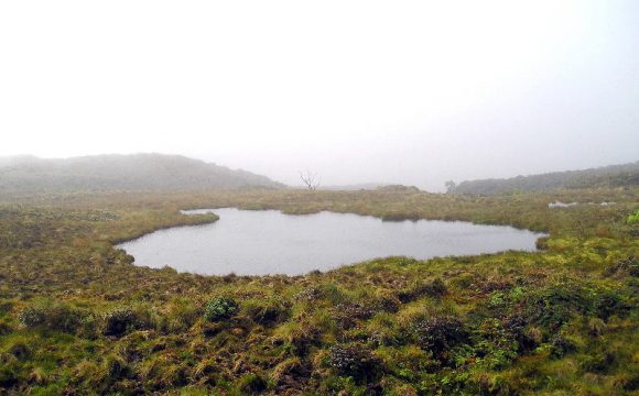
Wai?ale?ale (or 'Rippling Waters') Lake
Waialeale (or ‘Rippling Waters’) Lake, located atop Mount Waialeale on the island of Kaua’i, Hawaii. Credit: Wikipedia Commons/Volcantrek8

As already noted, the “wettest place on Earth” changes over time. This should come as no surprise, considering that weather patterns have been known to shift, not only in the course of an average year, but also over the course of centuries and millennia.

Nevertheless, those places that experience over 10 meters of precipitation are generally found within the tropical regions of the world, places known for experiencing intense and prolonged rainy seasons, and where lush tropical rainforests have existed for thousands of years. Here is a recent list of the top 10 locations.

But with anthropogenic climate change becoming a growing factor in planetary weather systems, this too could be subject to change. In the coming decades, and centuries, who’s to say where the most precipitation will fall on planet Earth?

We have written many interesting articles about rainfall and precipitation here at Universe Today. Here’s What are Tornadoes?, What is Tornado Alley?, Where do Hurricanes Occur?, What is a Warm Front?, and How Does Fog Form?

For more information, check out the US Geological Survey’s page on Precipitation: The Water Cycle and NASA’s Global Precipitation Measurement page.

Astronomy Cast also has an episode on the subject – Episode 226: Weather

Sources:

SpaceX’s Space Coast Launch Facilities Escape Hurricane Matthew’s Wrath, May Resume Launches this Year

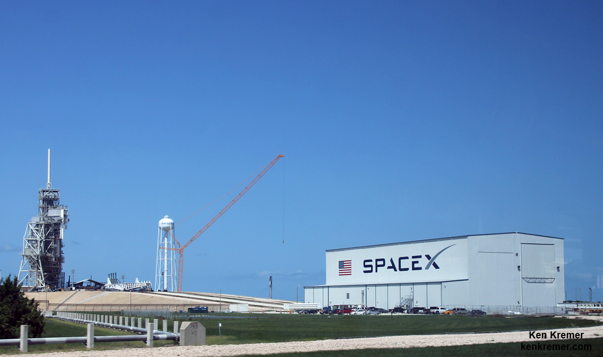
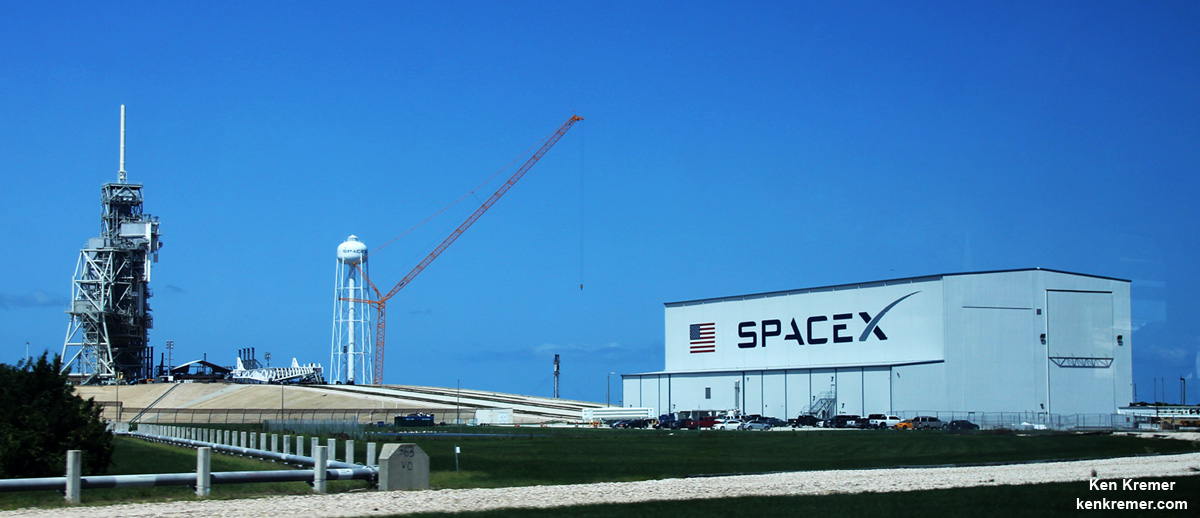
SpaceX is renovating Launch Complex 39A at the Kennedy Space Center for launches of the Falcon Heavy and human rated Falcon 9. Credit: Ken Kremer/kenkremer.com
SpaceX is renovating Launch Complex 39A at the Kennedy Space Center for launches of the Falcon Heavy and human rated Falcon 9.  Credit: Ken Kremer/kenkremer.com
SpaceX is renovating Launch Complex 39A at the Kennedy Space Center for launches of the Falcon Heavy and human rated Falcon 9. Credit: Ken Kremer/kenkremer.com

SpaceX’s key launch facilities on the Florida Space Coast escaped the wrath of Hurricane Matthew’s 100 mph wind gusts late last week, suffering only some exterior damage to the satellite processing building, a company spokesman confirmed to Universe Today.

Furthermore, the aerospace firm still hopes to resume launches of their Falcon 9 rocket before the end of this year following September’s rocket explosion, according to remarks made by SpaceX President Gwynne Shotwell over the weekend.

“Hurricane Matthew caused some damage to the exterior of SpaceX’s payload processing facility [PPF] at Space Launch Complex-40 at Cape Canaveral Air Force Station,” SpaceX spokesman John Taylor told Universe Today.

The payload processing facility (PPF) is the facility where the satellites and payloads are processed to prepare them for flight and launches on the firm’s commercial Falcon 9 rockets.

Some exterior panels were apparently blown out by the storm.

The looming threat of a direct hit by the Category 4 storm Hurricane Matthew on Friday, Oct. 7, on Cape Canaveral and the Kennedy Space Center (KSC) forced the closure of both facilities before the storm hit. They remained closed over the weekend except to emergency personal.

The deadly storm also caused some minor damage to the Kennedy Space Center and USAF facilities on the base.

Meanwhile competitor ULA also told me their facilities suffered only minor damage.

However the base closure will likely result in a few days launch delay of the ULA Atlas V rocket carrying the NASA/NOAA GOES-R weather satellite to geostationary orbit, which had been slated for Nov. 4.

The PPF is located on Cape Canaveral Air Force Station, a few miles south of the Falcon 9 launch pad at Space Launch Complex-40 (SLC-40).

The PPF is inside the former USAF Solid Motor Assembly Building (SMAB) used for the now retired Titan IV rockets.

Fortunately, SpaceX has another back-up facility at pad 40 where technicians and engineers can work to prepare the rocket payload for flight.

“The company has a ready and fully capable back-up for processing payloads at its SLC-40 hangar annex building,” Taylor elaborated.

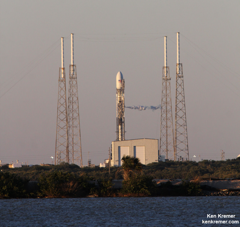
SpaceX Falcon 9 rocket venting prior to launch scrub for SES-9 communications satellite on Feb. 26, 2016 from Pad 40 at Cape Canaveral, FL. Credit: Ken Kremer/kenkremer.com
SpaceX Falcon 9 rocket on pad 40 with backup processing hanger visible, prior to launch of SES-9 communications satellite in March 2016 at Cape Canaveral Air Force Station, FL. Credit: Ken Kremer/kenkremer.com

And except for the minor damage to the PPF facility where payloads are processed, SpaceX says there was no other damage to infrastructure at pad 40 or to Launch Complex 39A at the Kennedy Space Center.

“There was no damage the company’s facilities at Pad 39A at Kennedy Space Center,” Taylor told me.

SpaceX Falcon 9 rocket moments after catastrophic explosion destroys the rocket and Amos-6 Israeli satellite payload at launch pad 40 at Cape Canaveral Air Force Station, FL,  on Sept. 1, 2016.  A static hot fire test was planned ahead of scheduled launch on Sept. 3, 2016. Credit: USLaunchReport
SpaceX Falcon 9 rocket moments after catastrophic explosion destroys the rocket and Amos-6 Israeli satellite payload at launch pad 40 at Cape Canaveral Air Force Station, FL, on Sept. 1, 2016. A static hot fire test was planned ahead of scheduled launch on Sept. 3, 2016. Credit: USLaunchReport

However SLC-40 is not operational at this time, since it was heavily damaged during the Sept. 1 launch pad disaster when a Falcon 9 topped with the Israeli Amos-9 comsat exploded on the launch pad during a routine prelaunch fueling operation and a planned first stage static fire engine test.

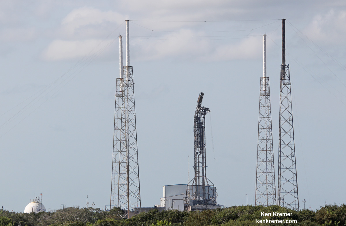
Mangled SpaceX Falcon 9 strongback with dangling cables (at right) as seen on Sept. 7 after prelaunch explosion destroyed the rocket and AMOS-6 payload at Space Launch Complex-40 at Cape Canaveral Air Force Station, FL on Sept. 1, 2016 . Credit: Ken Kremer/kenkremer.com
Mangled SpaceX Falcon 9 strongback with dangling cables (at right) as seen on Sept. 7 after prelaunch explosion destroyed the rocket and AMOS-6 payload at Space Launch Complex-40 at Cape Canaveral Air Force Station, FL on Sept. 1, 2016. Credit: Ken Kremer/kenkremer.com

As SpaceX was launching Falcon 9 rockets from pad 40, they have been simultaneously renovating and refurbishing NASA’s former shuttle launch pad at Launch Complex 39A at the Kennedy Space Center (KSC) which they leased from NASA.

SpaceX plans to start launching their new Falcon Heavy booster from pad 39A in 2017 as well as human rated launches of the Falcon 9 with the Crew Dragon to the ISS.

However, following the pad 40 disaster, SpaceX announced plans to press pad 39A into service for commercial Falcon 9 satellite launches as well.

SpaceX President Gwynne Shotwell recently said that the company hoped to resume launches in November while they search for a root cause to the pad 40 catastrophe – as I reported here.

Speaking at the annual meeting of the National Academy of Engineering in Washington, D.C. on Oct. 9 Shotwell indicated that investigators are making progress to determine the cause of the mishap.

“We’re homing in on what happened,” she said, according to a story by Space News. “I think it’s going to point not to a vehicle issue or an engineering design issue but more of a business process issue.”

Space News said that she did not elaborate further.

Stay tuned here for Ken’s continuing Earth and Planetary science and human spaceflight news.

Ken Kremer

Launch of GOES-R Transformational Weather Satellite Likely Delayed by Hurricane Matthew

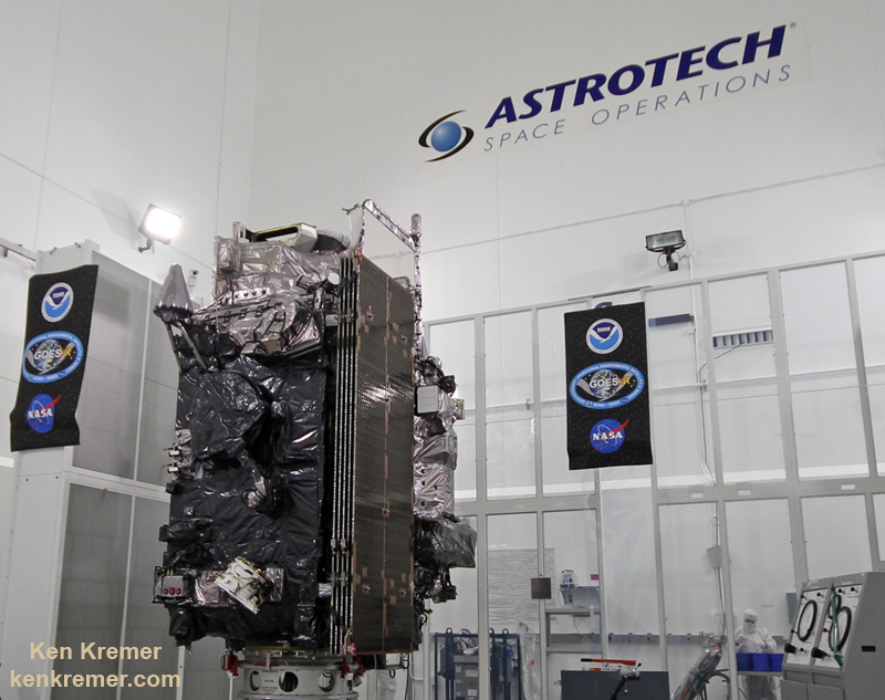
The NASA/NOAA GOES-R (Geostationary Operational Environmental Satellite - R Series) being processed at Astrotech Space Operations, in Titusville, FL, in advance of launch on a ULA Atlas V on Nov. 19, 2016. GOES-R will be America’s most advanced weather satellite. Credit: Ken Kremer/kenkremer.com
The NASA/NOAA GOES-R (Geostationary Operational Environmental Satellite - R Series) being processed at Astrotech Space Operations, in Titusville, FL, in advance of the planned launch on a ULS Atlas V on Nov 4, 2016.  GOES-R will be America’s most advanced weather satellite. Credit: Ken Kremer/kenkremer.com
The NASA/NOAA GOES-R (Geostationary Operational Environmental Satellite – R Series) being processed at Astrotech Space Operations, in Titusville, FL, in advance of the planned launch on a ULA Atlas V likely delayed from Nov 4, 2016 by Hurricane Matthew. GOES-R will be America’s most advanced weather satellite. Credit: Ken Kremer/kenkremer.com

Next month’s launch of GOES-R – a new and advanced transformational weather satellite that will vastly enhance the quality, speed and accuracy of weather forecasting – will likely be delayed a few days due to lingering storm related effects of deadly Hurricane Matthew on launch preparations at Cape Canaveral Air Force Station and the Kennedy Space Center (KSC), Universe Today confirmed with launch provider United Launch Alliance (ULA).

“The GOES-R launch will likely be delayed due to Hurricane Matthew,” ULA spokeswoman Lyn Chassagne told Universe Today.

Liftoff of the NASA/NOAA GOES-R (Geostationary Operational Environmental Satellite – R Series) weather satellite atop a United Launch Alliance (ULA) Atlas V rocket had been scheduled for Nov. 4 at 5:40 p.m. from Space Launch Complex 41 (SLC-41) on Cape Canaveral Air Force Station.

GOES-R is the first in a new series of American’s most powerful and most advanced next generation weather observation satellites.

It’s ironic that awful weather is impacting the launch of this critical weather satellite.

It’s not known how long any postponement would be – perhaps only a few days since preliminary indications are that the base suffered only minor damage and there are no reports of major damage.

“Our teams are still doing a damage assessment. So we don’t have a status about all of our infrastructure yet,” Chassagne told me.

“A preliminary assessment shows that we have some minor damage to a few of our facilities. We had no rockets on the pads. So there is no damage to hardware.”

Damage assessment teams are evaluating the launch pad and launch facilities in detail right now.

“Since we still have emergency response teams in assessing, we don’t know how long the delay will be until we get those assessments.”

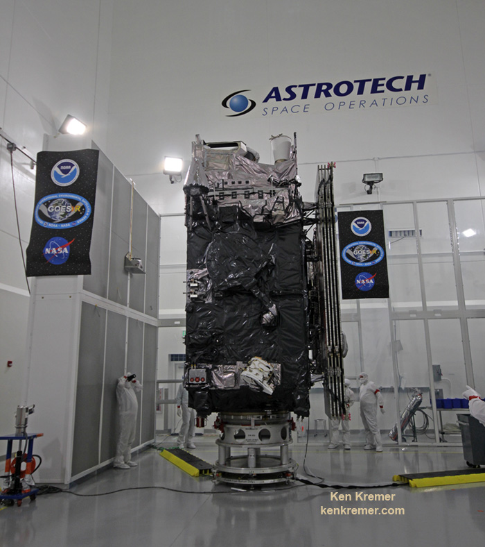
The NASA/NOAA GOES-R (Geostationary Operational Environmental Satellite - R Series) being processed at Astrotech Space Operations, in Titusville, FL, in advance of the planned launch on a ULA Atlas V likely delayed from Nov 4, 2016 by Hurricane Matthew.  GOES-R will be America’s most advanced weather satellite. Credit: Ken Kremer/kenkremer.com
The NASA/NOAA GOES-R (Geostationary Operational Environmental Satellite – R Series) being processed at Astrotech Space Operations, in Titusville, FL, in advance of the planned launch on a ULA Atlas V likely delayed from Nov 4, 2016 by Hurricane Matthew. GOES-R will be America’s most advanced weather satellite. Credit: Ken Kremer/kenkremer.com

The looming threat of a direct hit on Cape Canaveral and KSC from the Category 4 storm Hurricane Matthew on Friday, Oct. 7, forced the closure of both facilities before the storm hit. They remained closed this weekend except to emergency personal.

“Got in today to assess. Light to moderate damage to our facilities. No damage to any flight assets,” tweeted ULA CEO Tory Bruno.

The base closures therefore also forced a halt to launch preparations at the Cape and pad 41.

The storm grazed by the Kennedy Space Center (KSC), Cape Canaveral Air Force Station (CCAFS) and the major population centers along the Florida Space Coast with wind gusts up to 107 mph – rather than making a direct impact as feared.

“Hurricane Matthew passed Cape Canaveral and Kennedy Space Center …. with sustained winds of 90 mph with gusts to 107 mph,” on Friday, NASA officials reported.

The storm passed “the space center about 26 miles off the tip of Cape Canaveral.”

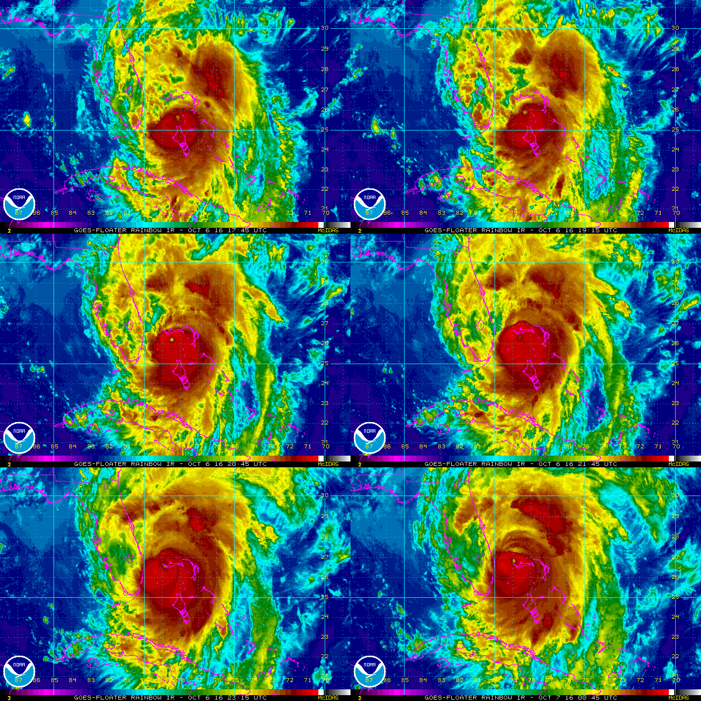
Cat 4 Hurricane Matthew track during the late evening of 6 Oct 2016.  Credit: NASA/NOAA
Cat 4 Hurricane Matthew track during the late evening of 6 Oct 2016. Credit: NASA/NOAA

The launch ULA facilities are now being thoroughly inspected before any launch preparation can proceed.

The satellite is in the final stages of preparation at the Astrotech Space Operations Facility in Titusville, FL as I recently observed during an up close visit in the High Bay cleanroom.

Check out this amazing rooftop video showing the high winds pummeling Titusville during Hurricane Matthew just a few miles away from Astrotech and the GOES-R satellite – from my space colleague Jeff Seibert.

Video caption: Before we bailed out on Thursday afternoon, I clamped one of my launch pad remote cameras to the power service post on our roof. Wind is blocked a lot by trees but none fell on the house. The highest recorded wind speed was 51mph at 7:30AM on Oct. 7, 2016. The minimum barometric pressure was 28.79″ from 8:20 – 9 AM. We got 5.9″ of rain. The ridge line faces due east. We never lost power. Credit: Jeff Seibert

Lockheed Martin is the prime contractor for GOES-R.

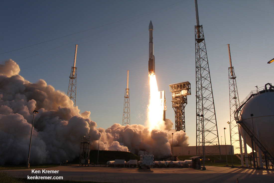
United Launch Alliance Atlas V rocket lifts off from Space Launch Complex 41 at Cape Canaveral Air Force Station carrying NASA’s Origins, Spectral Interpretation, Resource Identification, Security-Regolith Explorer, or OSIRIS-REx spacecraft on the first U.S. mission to sample an asteroid, retrieve at least two ounces of surface material and return it to Earth for study.  Liftoff was at 7:05 p.m. EDT on September 8, 2016 in this remote camera view taken from inside the launch pad perimeter.  Note the newly install crew access arm and white room for astronaut flights atop Atlas starting in early 2018.   Credit: Ken Kremer/kenkremer.com
United Launch Alliance Atlas V rocket lifts off from Space Launch Complex 41 at Cape Canaveral Air Force Station carrying NASA’s Origins, Spectral Interpretation, Resource Identification, Security-Regolith Explorer, or OSIRIS-REx spacecraft on the first U.S. mission to sample an asteroid on September 8, 2016. GOES-R launch on an Atlas V planned for Nov. 4 is likely delayed due to Hurricane Matthew. Credit: Ken Kremer/kenkremer.com

Whenever it does launch, GOES-R will blast off on a ULA Atlas V in the very powerful 541 configuration, augmented by four solid rocket booster on the first stage.

It will be launched to a Geostationary orbit some 22,300 miles above Earth.

But ULA has not yet begun assembling the Atlas V booster inside the Vertical Integration Facility (VIF) at SLC-41 due to the storm.

Because of Hurricane Matthew, the first stage arrival had to be postponed. The second stage is already in port at the Delta operations center and being integrated.

“The first stage booster is not yet at the Cape,” Chassagne confirmed.

However, conditions at the Cape have improved sufficiently for the US Air Force to clear its shipment into port, as of this evening.

“We just cleared CCAFS to be able to accept a booster for the GOES-R launch–how appropriate that GOES is a weather satellite!” wrote Brig. Gen. Wayne Monteith, commander of the Air Force’s 45th Space Wing at Patrick Air Force Base, in a Facebook update late today, Oct. 9.

“We are returning to full mission capability and our status as the World’s Premier Gateway to Space.”

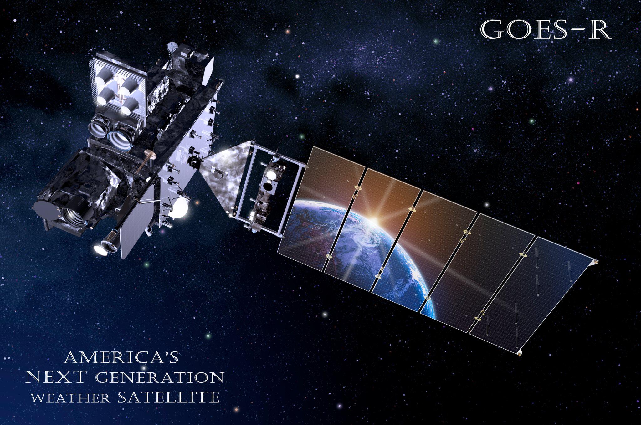
Artists concept for  NASA/NOAA GOES-R (Geostationary Operational Environmental Satellite - R Series) advanced weather satellite in Earth orbit. Credit: NASA/NOAA
Artists concept for NASA/NOAA GOES-R (Geostationary Operational Environmental Satellite – R Series) advanced weather satellite in Earth orbit. Credit: NASA/NOAA

Stay tuned here for Ken’s continuing Earth and Planetary science and human spaceflight news.

Ken Kremer

GOES-R logo.  Credit: NASA/NOAA
GOES-R logo. Credit: NASA/NOAA

Hurricane Matthew Grazes Kennedy Space Center and Cape Canaveral

Aerial view of the Vehicle Assembly Building (VAB) at NASA’s Kennedy Space Center (KSC) on Oct. 8, 2016 by damage assessment and recovery team surveying the damage at KSC the day after Hurricane Matthew passed by Cape Canaveral on Oct. 7, 2016 packing sustained winds of 90 mph with gusts to 107 mph. Credit: NASA/Cory Huston
Aerial view of the Vehicle Assembly Building (VAB) at NASA’s Kennedy Space Center (KSC) on Oct. 8, 2016 by damage assessment and recovery team surveying the damage at KSC the day after Hurricane Matthew passed by Cape Canaveral on Oct. 7, 2016 packing sustained winds of 90 mph with gusts to 107 mph.  Credit: NASA/Cory Huston
Aerial view of the Vehicle Assembly Building (VAB) at NASA’s Kennedy Space Center (KSC) on Oct. 8, 2016 by damage assessment and recovery team surveying the damage at KSC the day after Hurricane Matthew passed by Cape Canaveral on Oct. 7, 2016 packing sustained winds of 90 mph with gusts to 107 mph. Credit: NASA/Cory Huston

The Kennedy Space Center (KSC), Cape Canaveral Air Force Station (CCAFS) and the major population centers along the Florida Space Coast were spared from major damage to infrastructure, homes and business after the deadly Cat 4 Hurricane Matthew grazed the region with 107 mph winds rather than making a direct impact as feared.

Although some of the base and Space Coast coastal and residential areas did suffer significant destruction most were very lucky to have escaped the hurricanes onslaught in relatively good shape, when it stayed at sea rather than making the forecast direct hit.

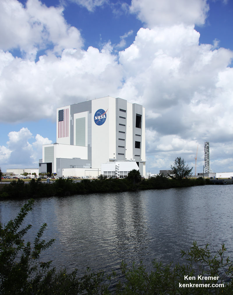
KSC’s iconic 525 foot tall Vehicle Assembly Building (VAB), the Complex 39 launch pads and the active launch pads at CCAFS are all standing and intact – as damage evaluations are currently underway by damage assessment and recovery teams from NASA and the US Air Force.

As Hurricane Matthew approached from the south Friday morning Oct. 7 along Florida’s Atlantic coastline, it wobbled east and west, until it finally veered ever so slightly some 5 miles to the East – thus saving much of the Space Coast launch facilities and hundreds of thousands of home and businesses from catastrophic damage from the expected winds and storm surges.

“Hurricane Matthew passed Cape Canaveral and Kennedy Space Center …. with sustained winds of 90 mph with gusts to 107 mph,” on Friday, NASA officials reported.

The storm passed “the space center about 26 miles off the tip of Cape Canaveral.”

Cat 4 Hurricane Matthew track during the late evening of 6 Oct 2016.  Credit: NASA/NOAA
Cat 4 Hurricane Matthew track during the late evening of 6 Oct 2016. Credit: NASA/NOAA

KSC and CCAFS did suffer some damage to buildings, downed power lines and some flooding and remains closed.

The Damage Assessment and Recovery Teams have entered the facilities today, Oct. 8, and are surveying the areas right now to learn the extent of the damage and report on when they can reopen for normal operations.

“After the initial inspection flight Saturday morning, it was determined that the center received some isolated roof damage, damaged support buildings, a few downed power lines, and limited water intrusion,” NASA reported late today.

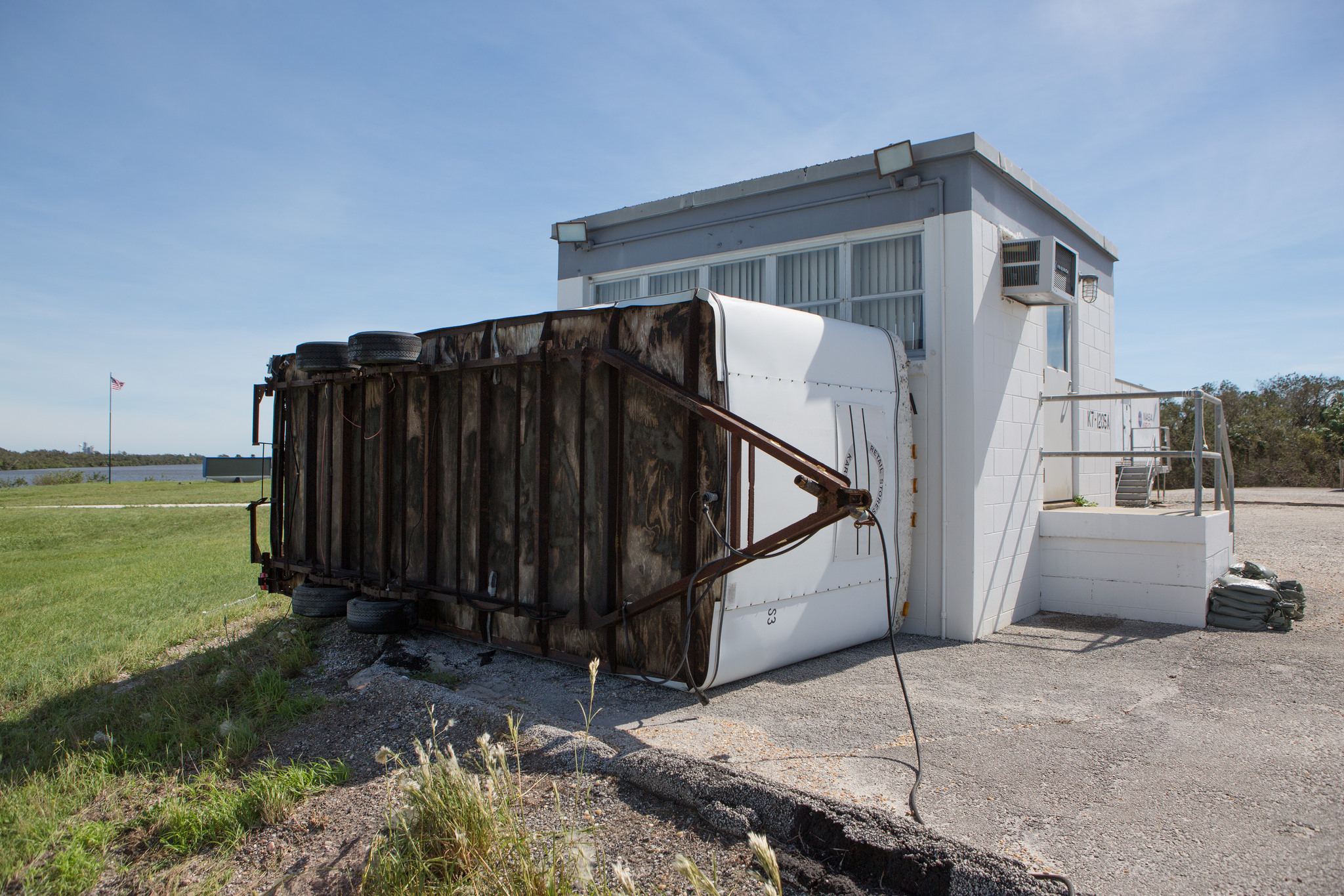
Hurricane force wind from Hurricane Matthew throw a concession stand up against the Spaceflight Now building at the LC 39 Press Site at the Kennedy Space Center in Florida on Oct. 7, 2016.  Credit: NASA/Cory Huston
Hurricane force wind from Hurricane Matthew throw a concession stand up against the Spaceflight Now building at the LC 39 Press Site at the Kennedy Space Center in Florida on Oct. 7, 2016. Credit: NASA/Cory Huston

Inspection teams are methodically going from building to building this weekend to assess Matthew’s impact.

“Since safety is our utmost concern, teams of inspectors are going from building-to-building assessing damage.”

It will take time to determine when the center can resume operations.

“Due to the complexity of this effort, teams need time to thoroughly inspect all buildings and roads prior to opening the Kennedy Space Center for regular business operations.”

Not until after a full inspection of the center will a list of damaged buildings and equipment be available. The next update will be available no earlier than Sunday afternoon.

A “ride-out team” of 116 remained at KSC and at work inside the emergency operations center in the Launch Control Center located adjacent to the VAB during the entire Hurricane period.

View of the Vehicle Assembly Building (VAB), Launch Control Center and Mobile Launcher from the KSC Launch Complex 39 Press Site.   NASA is upgrading the VAB with new platforms to assemble and launch  NASA’s Space Launch System rocket at the Kennedy Space Center in Florida.  Credit: Ken Kremer/kenkremer.com
View of the Vehicle Assembly Building (VAB), Launch Control Center and Mobile Launcher from the KSC Launch Complex 39 Press Site. NASA is upgrading the VAB with new platforms to assemble and launch NASA’s Space Launch System rocket at the Kennedy Space Center in Florida. Credit: Ken Kremer/kenkremer.com

It took until Friday afternoon for winds to drop below 40 knots start preliminary damage assessments.

“KSC is now in a “Weather Safe” condition as of 2 p.m. Friday. While there is damage to numerous facilities at KSC, it consists largely roof damage, window damage, water intrusion, damage to modular buildings and to building siding.”

Teams are also assessing the CCAFS launch pads, buildings and infrastructure. Some buildings suffered severe damage.

“We have survived a catastrophic event that could have easily been cataclysmic. It is only by grace and a slight turn in Matthew’s path that our base and our barrier island homes were not destroyed or covered in seven feet of water,” wrote Brig. Gen. Wayne Monteith, commander of the Air Force’s 45th Space Wing at Patrick Air Force Base, in a Facebook update.

“There is a lot of debris throughout the base.”

“We are still experiencing deficiencies in critical infrastructure, consistent power, emergency services, communications and hazardous material inspections that make portions of our base uninhabitable or potentially dangerous.”

Severely damaged building on Cape Canaveral Air Force Station.  Credit: 45th Space Wing
Severely damaged building on Cape Canaveral Air Force Station. Credit: 45th Space Wing

Of particular importance is Space Launch Complex 41 (SLC-41) where the next scheduled liftoff is slated for Nov. 4.

The launch involves America’s newest and most advanced weather satellite on Nov 4. It’s named GOES-R and was slated for blastoff from Cape Canaveral Air Force Station pad 41 atop a United Launch Alliance (ULA) Atlas V rocket.

The launch facilities will have to be thoroughly inspected before the launch can proceed.

The satellite is in the final stages of preparation at the Astrotech Space Operations Facility in Titusville, FL as I recently observed during an up close visit in the High Bay cleanroom.

The NASA/NOAA GOES-R (Geostationary Operational Environmental Satellite - R Series) being processed at Astrotech Space Operations, in Titusville, FL, in advance of the planned launch on a ULS Atlas V on Nov 4, 2016.  GOES-R will be America’s most advanced weather satellite. Credit: Ken Kremer/kenkremer.com
The NASA/NOAA GOES-R (Geostationary Operational Environmental Satellite – R Series) being processed at Astrotech Space Operations, in Titusville, FL, in advance of the planned launch on a ULA Atlas V on Nov 4, 2016. GOES-R will be America’s most advanced weather satellite. Credit: Ken Kremer/kenkremer.com

The major Space Coast cities in Brevard county suffered much less damage then feared, although some 500,000 residents lost power.

Local government officials allowed most causeway bridges to the barrier islands to be reopened by Friday evening, several local colleagues told me.

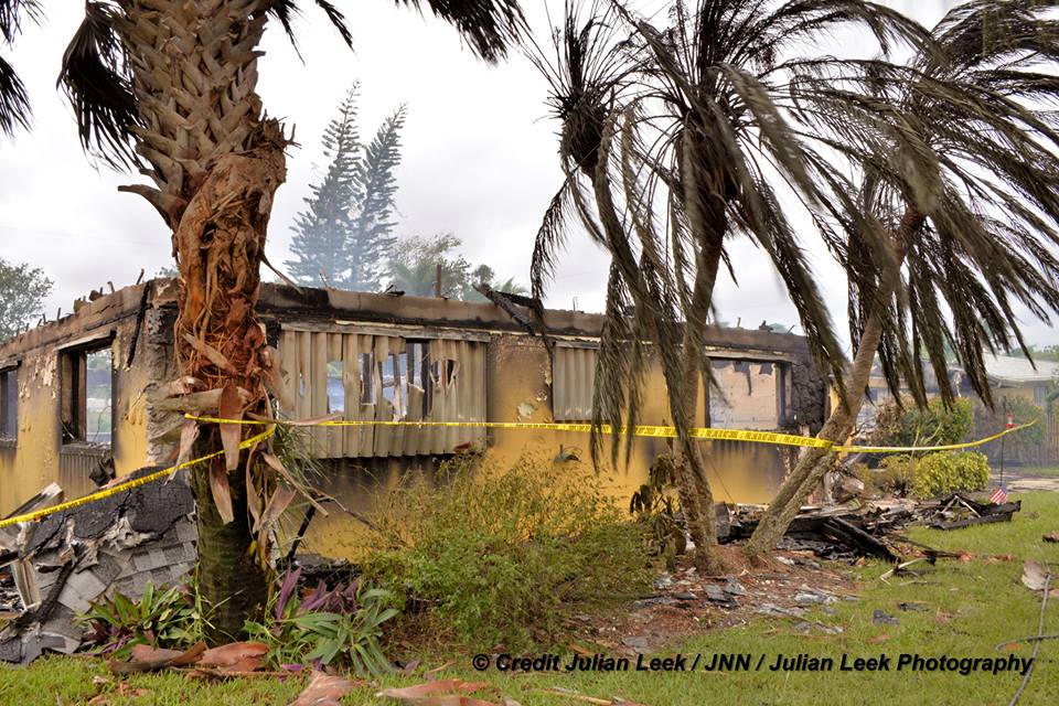
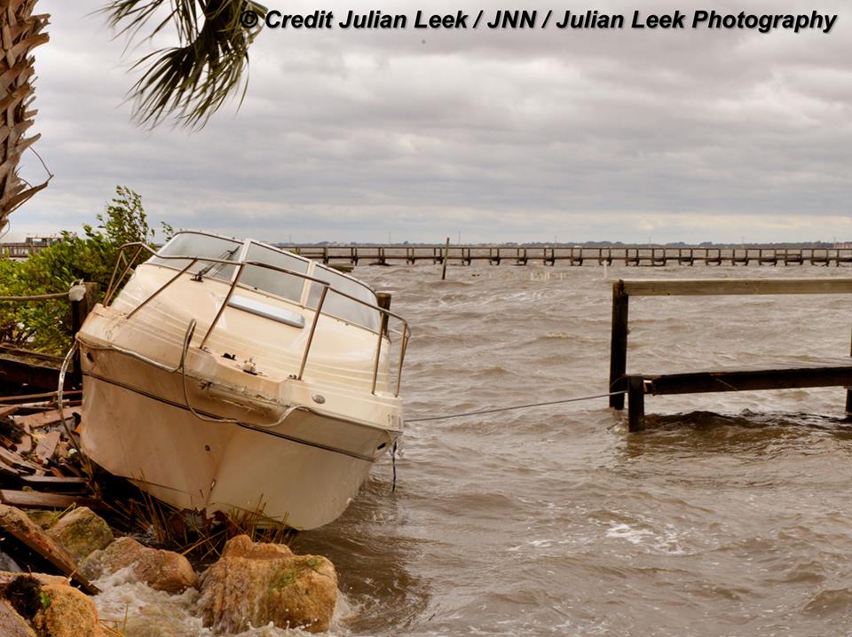
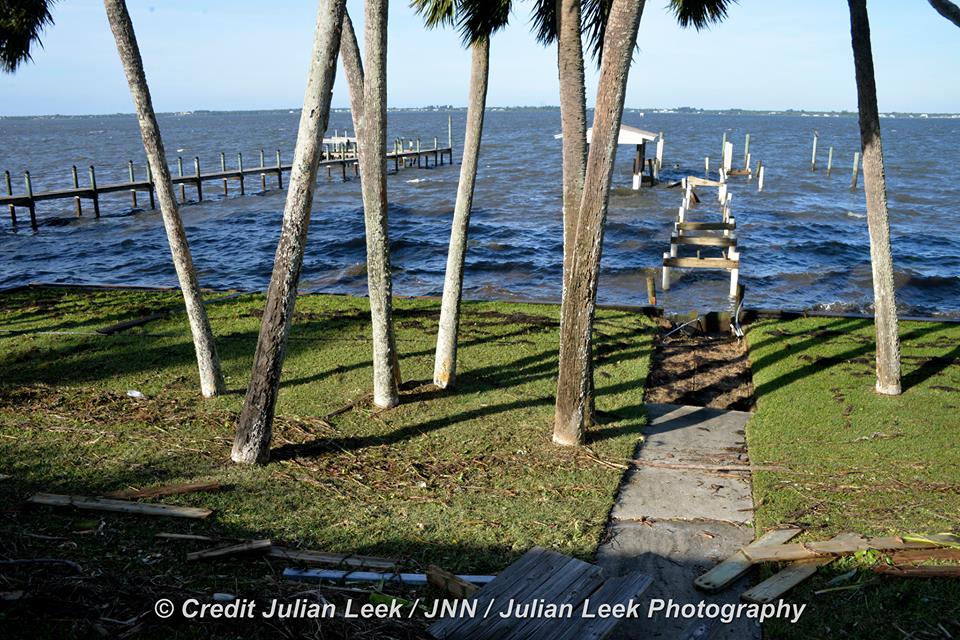
Here’s some images of damage to the coastal piers, town and a destroyed house from the Melbourne Beach and Satellite Beach areas from my space colleague Julian Leek.

Home destroyed by fire in Satellite Beach. Credit: Julian Leek
Local damage in South Melbourne Beach. Credit: Julian Leek

Stay tuned here for Ken’s continuing Earth and Planetary science and human spaceflight news.

Ken Kremer

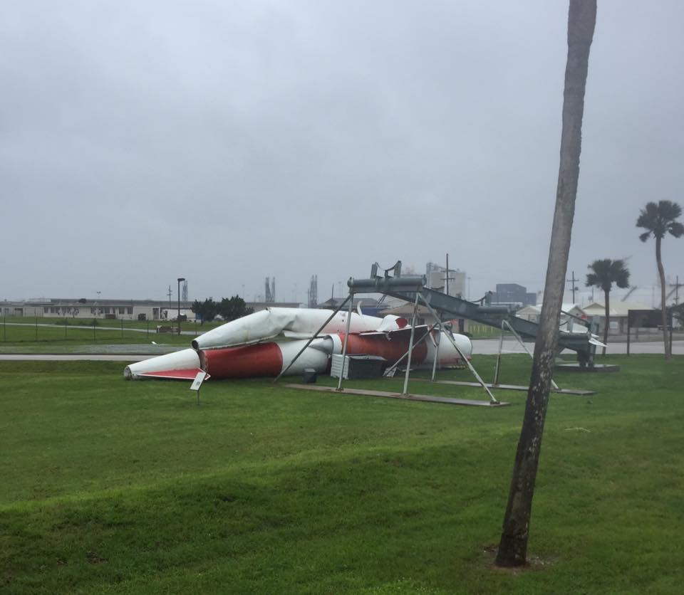
Navaho missile on display at the CCAFS south gate suffered severe damage from Hurricane Matthew and crumpled to the ground.  Credit: 45th Space Wing
Navaho missile on display at the CCAFS south gate suffered severe damage from Hurricane Matthew and crumpled to the ground. Credit: 45th Space Wing
Local damage in South Melbourne Beach. Credit: Julian Leek

Imminent Impact of Deadly Cat 4 Hurricane Matthew Forces Closure of Kennedy Space Center and Mass Coastal Evacuations

Cat 4 Hurricane Matthew track during the late evening of 6 Oct 2016. Credit: NASA/NOAA
Cat 4 Hurricane Matthew track during the late evening of 6 Oct 2016.  Credit: NASA/NOAA
Cat 4 Hurricane Matthew track during the late evening of 6 Oct 2016. Credit: NASA/NOAA

The imminent impact of the already deadly Category 4 Hurricane Matthew along the Florida Space Coast tonight, Thursday, October 6, has forced the closure of NASA’s Kennedy Space Center (KSC) and mass evacuations along the US East coast from Florida, to Georgia to the Carolinas.

“Hurricane Matthew, currently an extremely dangerous Category 4 storm on the Saffir-Simpson Hurricane Wind Scale, continues to bear down on the southeastern United States,” says NASA in an update today.

NASA has closed KSC for today and tomorrow, at a minimum and the center has entered HurrCon 1 status.

“Under the current storm track, peak winds are forecast to be 125 mph sustained with gusts to 150 mph, however a shift in the track even slightly could improve the wind forecast somewhat,” wrote NASA’s Brian Dunbar.

“The Kennedy Space Center is closed today, Oct. 6, and Friday for Hurricane Matthew. Kennedy Space Center is now in HurrCon 1 status, meaning a hurricane is imminent.”

The Kennedy Space Center on Florida’s Space Coast is home to the iconic Vehicle Assembly Building (VAB) – the most well known building at NASA – as well as Launch Complex’s 39 A and B which launched American astronauts to Moon and thereafter Space Shuttles for three decades.

The launch pads sit precariously close to the Atlantic Ocean shoreline – just a few hundred yards (meters) away!

View of the VAB and Mobile Launcher from the KSC Launch Complex 39 Press Site.   NASA is upgrading the VAB with new platforms to assemble and launch  NASA’s Space Launch System rocket at the Kennedy Space Center in Florida.  Credit: Ken Kremer/kenkremer.com
View of the VAB and Mobile Launcher from the KSC Launch Complex 39 Press Site. NASA is upgrading the VAB with new platforms to assemble and launch NASA’s Space Launch System rocket at the Kennedy Space Center in Florida. Credit: Ken Kremer/kenkremer.com

“Across the spaceport, essential personnel are preparing facilities for the storm’s arrival,” according to George Diller, NASA Kennedy Space Center Public Affairs Officer.

“Hurricane Matthew is expected to make its closest approach to the Cape Canaveral/Kennedy area overnight Thursday and into Friday morning, bringing with it the potential for heavy rain, storm surge and hurricane-force winds.”

The last time a major Hurricane impacted near KSC and the Space Coast was in 2004. The VAB suffered some outside damage.

The Kennedy Space Center Visitor Complex is also closed on Thursday, October 6 and Friday, October 7.

Hurricane Matthew is bearing down on the US East Coast right now at Florida’s Peninsula and is tracking north.

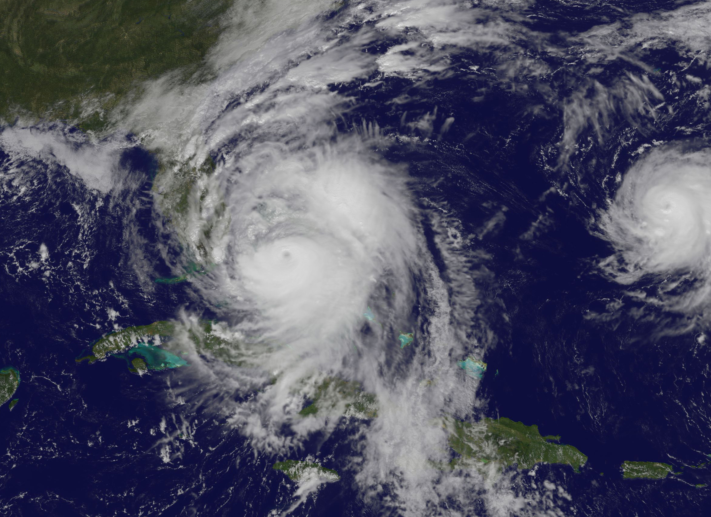
This visible image on Oct. 6 at 1:00 p.m. EDT from NOAA's GOES-East satellite shows Hurricane Matthew as it regained Category 4 Hurricane Status.  Credits: NASA/NOAA GOES Project
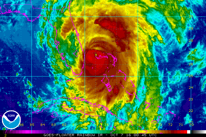
This visible image on Oct. 6 at 1:00 p.m. EDT from NOAA’s GOES-East satellite shows Hurricane Matthew as it regained Category 4 Hurricane Status. Credits: NASA/NOAA GOES Project
Herein is the latest satellite imagery from NASA and NOAA of this evening.

Mass evacuations have been ordered and States of Emergencies declared by the Governors of Florida, Georgia and North and South Carolina.

The high winds, storm surge of potentially 5 to 11 feet, drenching rains and extensive flooding is expected to cause massive damage and devastation to homes, businesses and infrastructure.

Cat 4 Hurricane Matthew track during the late evening of 6 Oct 2016.  Credit: NASA/NOAA
Cat 4 Hurricane Matthew track during the late evening of 6 Oct 2016. Credit: NASA/NOAA

Hundreds of thousands of folks have left their home over the past 2 days. Many gas stations are dry and grocery store shelves emptied.

Matthew will cause a wide swath of destruction and potentially deaths along hundreds of miles of US shoreline and inland areas as the massive storm hugs the coast like none before in recorded history.

Furthermore, hundreds of thousands of folks are expected to lose power as well, for days and perhaps weeks.

Hundreds of deaths and massive destruction in Haiti, Cuba and elsewhere in the Caribbean can already be blamed on Hurricane Matthew – a storm like none other and by far the worst since Superstorm Sandy and Hurricane Katrina.

After the storm passes KSC will evaluate all its facilities.

“Once the storm has passed, center facilities and infrastructure will be assessed and employees will be cleared to return when it is safe to do so,” Diller.

Indeed NASA was preparing to launch America’s newest and most advanced weather satellite on Nov 4. It’s named GOES-R and was slated for blastoff from Cape Canaveral Air Force Station atop a ULA Atlas V on Nov. 4.

The launch facilities will have to be thoroughly inspected before the launch can proceed.

The satellite is in the final stages of preparation at the Astrotech Space Operations Facility in Titusville, FL as I recently observed during an up close visit in the High Bay cleanroom.

Titusville and Astrotech could suffer a direct hit from Matthew. But the satellite has been secured.

The NASA/NOAA GOES-R (Geostationary Operational Environmental Satellite - R Series) being processed at Astrotech Space Operations, in Titusville, FL, in advance of the planned launch on a ULS Atlas V on Nov 4, 2016.  GOES-R will be America’s most advanced weather satellite. Credit: Ken Kremer/kenkremer.com
The NASA/NOAA GOES-R (Geostationary Operational Environmental Satellite – R Series) being processed at Astrotech Space Operations, in Titusville, FL, in advance of the planned launch on a ULS Atlas V on Nov 4, 2016. GOES-R will be America’s most advanced weather satellite. Credit: Ken Kremer/kenkremer.com

Here is the latest Advisory from the National Hurricane Center (NHC) as of 8 PM EDT Oct 6.

At 800 PM EDT (0000 UTC), the eye of Hurricane Matthew was located over the western end of Grand Bahama Island near latitude 26.6 North, longitude 78.9 West. The hurricane is moving toward the northwest near 13 mph (20 km/h), and this general motion is expected to continue tonight with a turn toward the north-northwest early Friday. On the forecast track, the eye of Matthew should move away from Grand Bahama Island during the next few hours, and move close to or over the east coast of the Florida peninsula through Friday night.

Reports from a NOAA Hurricane Hunter aircraft indicate that maximum sustained winds are now near 130 mph (210 km/h) with higher gusts. Matthew is a category 4 hurricane on the Saffir-Simpson Hurricane Wind Scale. Some fluctuations in intensity are likely while the hurricane moves toward the coast of Florida.

Hurricane-force winds extend outward up to 60 miles (95 km) from the center and tropical-storm-force winds extend outward up to 185 miles (295 km). Settlement Point in the Bahamas recently reported a sustained wind of 79 mph (128 km/h) with a gust of 105 mph (169 km/hr). The Lake Worth Pier near Palm Beach, Florida, recently reported a sustained wind of 46 mph (74 km/h) and a wind gust of 60 mph (96 km/h).

The minimum central pressure estimated from NOAA Hurricane Hunter data is 939 mb (27.73 inches).

…….

The latest weather briefing indicates that “tropical storm force winds beginning at Cape Canaveral tonight at midnight with hurricane force winds starting at about 6 a.m.

A hurricane ride-out crew of 116 has arrived at KSC this evening to prepare for Matthew.

“All facilities at Kennedy Space Center and Cape Canaveral Air Force Station have been secured.”

SpaceX is currently renovating and refurbishing pad 39A to launch their commercial Falcon 9 and Falcon Heavy rockets as well the Crew Dragon with astronauts on mission to the ISS.

The eye of the storm is barreling towards KSC at this moment. Stay tuned for the outcome.

SpaceX is renovating Launch Complex 39A at the Kennedy Space Center for launches of the Falcon Heavy and human rated Falcon 9.  Credit: Ken Kremer/kenkremer.com
SpaceX is renovating Launch Complex 39A at the Kennedy Space Center for launches of the Falcon Heavy and human rated Falcon 9. Credit: Ken Kremer/kenkremer.com

Stay tuned here for Ken’s continuing Earth and Planetary science and human spaceflight news.

Ken Kremer

Celebrate International Observe the Moon Night on Saturday, Oct. 8 2016!

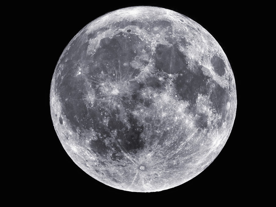
A full moon captured July 18, 2008. Credit: NASA/Sean Smith

2016savethedate-300x201

This Saturday, October 8, 2016, is International Observe the Moon Night (InOMN), an annual worldwide public event that encourages observation, appreciation, and understanding of our Moon and its connection to NASA planetary science and exploration. InOMN is sponsored by NASA’s Lunar Reconnaissance Orbiter, NASA’s Solar System Exploration Research Virtual Institute (SSERVI), and the Lunar and Planetary Institute.

LROC WAC image of the Moon. Credit: NASA/LRO

Everyone on Earth is invited to join the celebration by hosting or attending an InOMN event — and uniting on one day each year to look at and learn about the Moon together. We encourage you to go to InOMN events near you, such as at your local planetariums or museums, or to go out and observe the moon yourself! You can find events near you at the InOMN site. You can also follow the InOMN Twitter feed to see what everyone is doing to celebrate!

800px-MoonMappers-LogoWithLRO

Our friends over at CosmoQuest are proud to be partners in this celebration of Earth’s natural satellite. There you can “Observe the Moon” all year long by taking part in lunar-themed activities, such as our Moon Mappers citizen science program, where you’ll get to look at some of the most detailed images taken by the LRO, and help our scientists study the moon and it’s surface. This excellent program is available free of charge, no matter the weather, time of day or your location – you get the best views of the Moon ever!

youngmoonmapper

Take some photos of your activities, whether outdoors observing or indoors mapping craters, and share them online at the CosmoQuest Twitter and Facebook feeds using the hashtag #observethemoon, and CosmoQuest will repost their favorites!

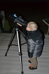
leif looking at the moon

Here are just a few of the media celebrations that have already been posted for InOMN!

One of CosmoQuest’s partners, the Astronomical Society of the Pacific, has a great document here celebrating recent lunar discoveries.

The Moon and More” is a music video starring musicians Javier Colon (Season 1 winner of NBC’s “The Voice”), and Matt Cusson in collaboration with NASA’s Goddard Space Flight Center and the Lunar Reconnaissance Orbiter (LRO) mission.
Credits: NASA’s Goddard Space Flight Center/David Ladd, producer

Satellite Views Show Hurricane Matthew Moving Towards U.S.

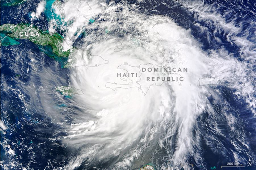
On October 4, 2016, Hurricane Matthew made landfall on southwestern Haiti as a category-4 storm—the strongest storm to hit the Caribbean nation in more than 50 years. Just hours after landfall, the Moderate Resolution Imaging Spectroradiometer (MODIS) on NASA’s Terra satellite acquired this natural-color image. At the time, Matthew had top sustained winds of about 230 kilometers (145 miles) per hour. Credit: NASA Earth Observatory image by Joshua Stevens

As Hurricane Matthew approaches the east coast of Florida, the evacuation of hundreds of thousands of people is taking place in Florida and South Carolina. Forecasters say the conditions appear to be favorable for the storm to restrengthen after it caused major damage to western Haiti and eastern Cuba. Matthew is now heading toward Florida, bringing with it the potential for heavy rain, storm surges and hurricane-force winds. The expected maximum sustained winds could be 130 mph (210 km/hr), and it could be the strongest hurricane to hit the region in 11 years

The National Hurricane Center said “Matthew is moving toward the northwest near 12 mph (19 kph), and this motion is expected to continue during the next 24 to 48 hours. On this track, Matthew will be moving across the Bahamas through Thursday, and is expected to be very near the east coast of Florida by Thursday evening, Oct. 6.”

The image above was taken by NASA’s Terra satellite on October 4, 2016, showing the hurricane over the eastern tip of Cuba and the eastern-most extent over Puerto Rico. Reports say it was the strongest storm to hit the Caribbean nation in more than 50 years.

Cameras on board the International Space Station captured these views of Hurricane Matthew today (October 5) as the now Category 3 storm moved to the north of Cuba:

NASA’s Kennedy Space Center released a statement that they closed at 1 p.m. today due to the approach of the hurricane, with essential personnel preparing facilities for the storm’s arrival.

Stu Ostro, a senior meteorologist at The Weather Channel, tweeted a satellite image of the hurricane, which has gone viral, which some say shows a face with a fiery eye, teeth and a sinister smile.

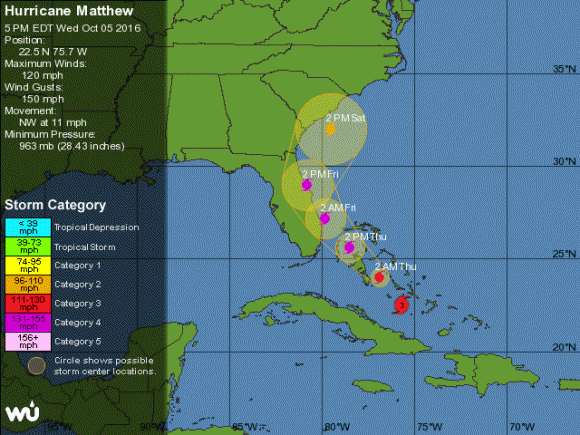
WeatherUnderground is tracking the storm and as of 6:00 pm ET on October 5, this was the projected path of the storm. You can click the image (or this link) to get the current tracking data on WeatherUnderground.

Projected path for Hurricane Matthew as of October 5, 2016. Click for updated map on WeatherUnderground.com.

This animation of NOAA’s GOES-East satellite imagery from Oct. 3 to Oct. 5 shows Hurricane Matthew make landfall on Oct. 4 in western Haiti and move toward the Bahamas on Oct. 5.

NOAA said tropical storm or hurricane conditions could affect South Carolina and North Carolina later this week or this weekend, even if the center of Matthew remains offshore, adding that “it is too soon to determine what, if any, land areas might be directly affected by Matthew next week. At a minimum, dangerous beach and boating conditions are
likely along much of the U.S. east coast during the next several days.”

For additional information see:
NASA’s page on Hurricane Matthew
NASA’s Earth Observatory website
National Hurricane Center