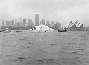
As an April Fool’s joke in 1978, Australian businessman Dick Smith claimed he was towing an iceberg from Antarctica to Sydney Harbour. He used a barge covered with white plastic and fire extinguisher foam in effort to convince those who gathered at the harbor to see it. Apparently, however, the idea is not such a joke after all. A team of engineers from France have studied the concept, did a simulation and found that icebergs floating around in the ocean could be tethered and towed to places that are experiencing a severe drought and water shortages.
The idea originally was conceived in the 1970’s by an graduate student named Georges Mougin, who even received some funds from a Saudi prince to test the idea, but not much came of it.
According to an article on PhysOrg, the French engineers looked into the idea and concluded that towing an iceberg from, for example, the waters around Newfoundland to the Canary Islands off the northwest coast of Africa, could be done, and would take just under five months when towed by a tugboat outfitted with a kite sail, traveling at about one knot.
The cost would be almost ten million dollars, however.
According to a simulated test, the iceberg would lose only 38 percent of its seven ton mass during the trip, if it was fitted with an insulated skirt.
Apparently Mougin is encouraged by the results and now at age 86 is trying to raise money for an actual iceberg-tow.
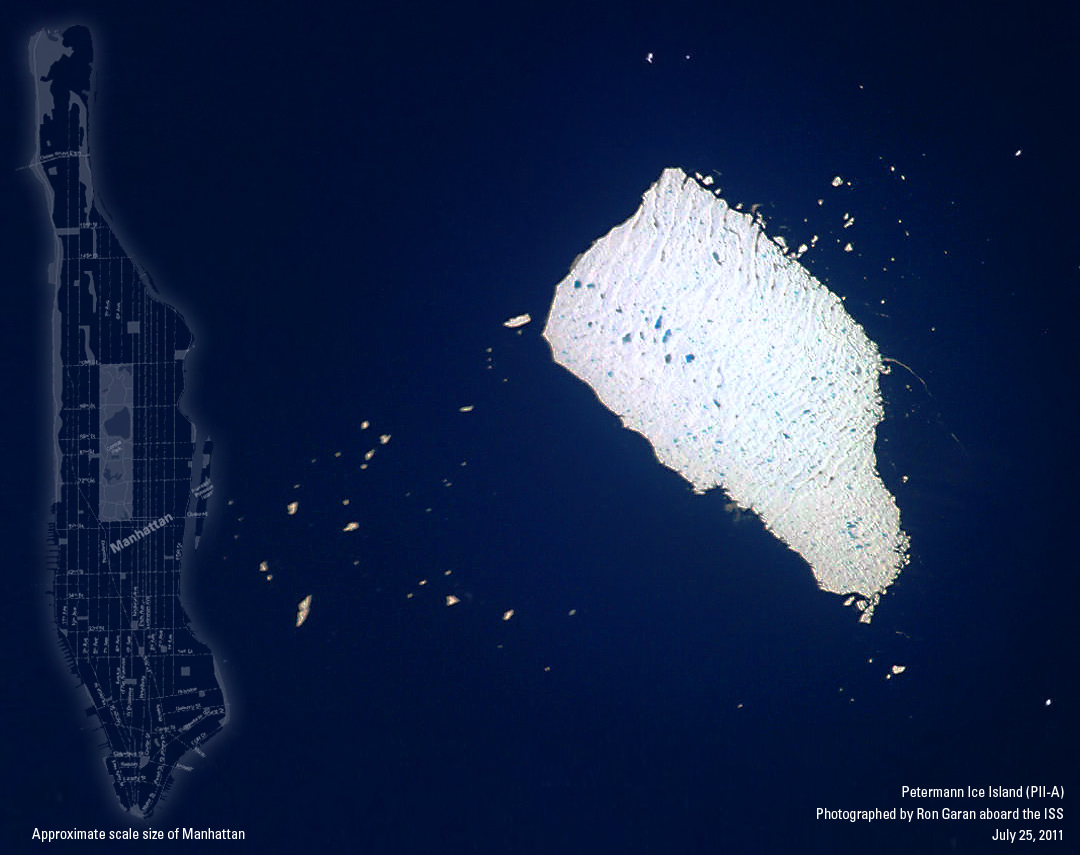
Taken by NASA astronaut and Expedition 27 flight engineer Ron Garan, this image shows the Petermann Ice Island (PII-A) currently adrift off the coast of Labrador. The island is a chunk of ice that broke off the Petermann Glacier in Greenland in August of 2010 and has been moving slowly southward ever since. It is currently about 21 square miles (55 square km) in size – nearly the same area as Manhattan!
Garan’s original photo was posted to his Twitter feed earlier today… I cropped the full-size version, rotated it so that south is down and edited it to bring out surface details in the island. Ridges in its surface can be seen as well as many bright blue meltwater ponds.
Overlaid on the left side is an approximate scale size of Manhattan. This thing is BIG!
PII-A is currently drifting toward Newfoundland but is unlikely to reach land… its base will run against the sea floor long before that. But it has been reported to be posing a problem for ships and offshore oil rigs. (Read more about PII-A on NASA’s Earth Observatory site here.)
When he’s not performing other duties aboard the Space Station, Ron Garan posts photos of Earth from orbit on his Twitter feed (@Astro_Ron) and also on his website FragileOasis.org, thereby sharing his unique and privileged perspective on our world. Founded by Garan, Fragile Oasis is a site that supports and publicizes many global projects supporting humanitarian and environmental missions. Visit, become a member, and you too can “learn, act, and make a difference.” After all, who better than an astronaut would know how much our world is connected, and how fragile it really is!
Image credit: NASA / Ron Garan. Edited by Jason Major.
PS: If you want an idea of how something like this would look like up close, check out this video below taken from a ship near one of the smaller pieces of the ice island!
_______________________
Jason Major is a graphic designer, photo enthusiast and space blogger. Visit his website Lights in the Dark and follow him on Twitter @JPMajor or on Facebook for the most up-to-date astronomy awesomeness!
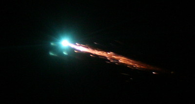
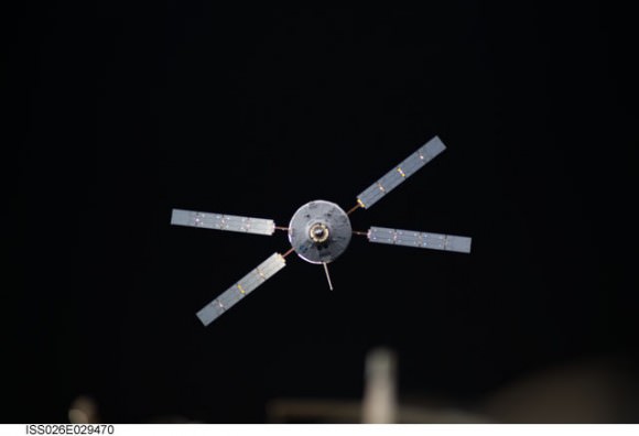
The Johannes Kepler ATV (Automated Transfer Vehicle) has undocked from the International Space station and will re- enter Earth’s atmosphere on June 21st ending its mission in fiery destruction.
The ATV has been docked with the ISS since February, where it delivered supplies, acted as a giant waste disposal and boosted the orbit of the International Space Station with its engines.
The X-wing ATV delivered approximately 7 tonnes of supplies to the station and will be leaving with 1,200kg of waste bags, including unwanted hardware.
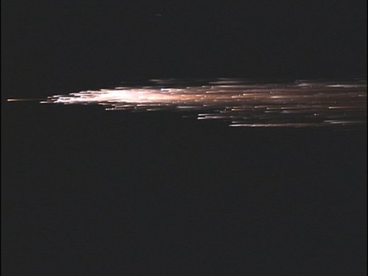
On June 21st at 17:07 GMT the craft will fire its engines and begin its suicide mission, tumbling and burning up as a bright manmade fireball over the Pacific Ocean. Any leftover debris will strike the surface of the Pacific ocean at 20:50 GMT.
During the ATV’s re-entry and destruction there will be a prototype onboard flight recorder (Black Box) transmitting data to Iridium satellites, as some aspects of a controlled destructive entry are still not well known.
ESA says that this area is used for controlled reentries of spacecraft because it is uninhabited and outside shipping lanes and airplane routes. Extensive analysis by ESA specialists will ensure that the trajectory stays within safe limits.
There still are some chances to see the ISS and Johannes Kepler ATV passing over tonight, but if you in a location where you can see the south Pacific skies starting at about 20:00 GMT, keep an eye out for a glorious manmade fireball.
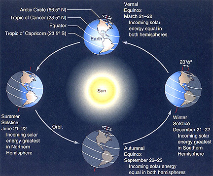
June 21st, 2011 is Summer Solstice – the longest day of the year.
This is the time when the Sun is at its highest or most northerly point in the sky in the Northern Hemisphere and when we receive the most hours of daylight. If you live in the Southern Hemisphere it is the reverse, so you will be having “Winter Solstice.”
Also known as “Midsummer” the Summer Solstice gets its name from the Latin for sol (sun) and sistere (to stand still). The Sun reaches its most Northerly point and momentarily stands still before starting its journey South in the sky again until it reaches its most Southerly point “Winter Solstice”, before repeating the cycle. This is basically how we get our seasons.
It’s not actually the Sun that moves North or South over the seasons although it may appear so. It’s the Earths axial tilt that causes the Sun to change position in the sky as the Earth orbits the Sun throughout the year.
Summer Solstice/ Midsummer is steeped in ancient folklore especially in Northern Europe with the most famous place directly related to it being Stonehenge, where the sun has been worshiped for thousands of years.
The Sun reaches its most Northerly point in the sky at 17:16 UTC momentarily and from that point forward starts to make its way South. This means the days will get shorter and shorter until Winter Solstice in December.
The Coalition for Space Exploration, a collective of many prominent, established aerospace firms has released the second part of its “Think Outside the Circle” campaign that highlights the positive influence of space exploration on our everyday lives. Continue reading “How Space Flight Keeps Us ‘Closer and Safer’”
Soon you may see an eerie spectacle on clear summer nights if you are located at latitudes between 50° and 70° north and south of the equator: Noctilucent Clouds.
These ghostly apparitions are a delight to see and are quite rare. It is incredibly difficult to predict exactly when they will appear, but we do know they should begin to appear soon.
The season for Noctilucent Clouds (Noctilucent = Latin for “Night Shining”) starts early June and continues into late July. They are seen just after dusk, or before dawn and an apparition can last around an hour.
These mysterious clouds, with their bizarre tenuous wispy shapes reminiscent of ripples in sand or the changing surface of a pool of water, spread like a glowing web across the northern sky. Colours can range from brilliant whites, with tinges of blue, pink and orange.
Formed by tiny ice crystals, they are the highest clouds in the Earth’s atmosphere, located in the mesosphere at altitudes of around 76 to 85 kilometers (47 to 53 miles) almost at the edge of space.
They are normally too faint to be seen, and are visible only when illuminated by sunlight from below the horizon, while the lower layers of the atmosphere are in the Earth’s shadow. Noctilucent clouds are not fully understood and are a recently discovered meteorological phenomenon, only being recorded for about 120 years.
Noctilucent clouds can only form under very restrictive conditions, and their occurrence can be used as a guide to changes in the upper atmosphere. Since their relatively recent classification, the occurrence of noctilucent clouds appears to be increasing in frequency, brightness and extent.
There is evidence that the relatively recent appearance of noctilucent clouds and their gradual increase, may be linked to climate change. Another recent theory is that some of these bright displays come from particulates and water vapour in the atmosphere left over from Space Shuttle launches.
How can you see them? Over the next couple of months look north during dusk and dawn and try and spot this mysterious and elusive phenomenon. They are best seen when the sun is between 6 and 16 degrees below the horizon, and seem to occur more frequently in the Northern hemisphere than the Southern.
KENNEDY SPACE CENTER – 50 Years ago this week, Alan B. Shepard became the first American to be launched into space. Shepard blasted off on May 5, 1961 from Cape Canaveral, Florida. NASA and the US Postal Service honored Shepard’s historic achievement today (May 4) at an Official First-Day-of-Issue dedication ceremony at NASA’s Kennedy Space Center in Florida.
Alan Shepard was one of the seven Project Mercury astronauts – who will be collectively known for all eternity as – “The Original 7”.
The US Postal Service simultaneously released two new 44 cent Forever Stamps at today’s commemoration, which bookend two historic space achievements – Shepard’s inaugural manned spaceflight aboard the Mercury capsule and NASA’s unmanned MESSENGER mission which recently became the first probe from Earth to achieve orbit about the Planet Mercury.
Fellow Mercury Astronaut Scott Carpenter attended the ceremony and unveiled the stamps along with Steve Masse, United States Postal Service Vice President of Finance at the Rocket Garden at the KSC Visitor Complex.
“Today we celebrate the 50th anniversary of many, many important issues, among them is the first steps from the home planet that were taken by the family of man,” said Carpenter.
Although Shepards suborbital flight aboard the one man “Freedom 7” Mercury capsule lasted barely 15½ minutes, the flight ignited America’s Moon landing effort and propelled American Astronaut Neil Armstrong to become the first human to set foot on the moon on July 20, 1969 during the Apollo 11 mission – one of the crowning technological achievements of the 20th Century.
The success of “Freedom 7” emboldened President John F. Kennedy to declare that America “should commit itself to achieving the goal, before this decade is out, of landing a man on the moon and returning him safely to the Earth,” just three weeks later on May 20.
“That was largely a response to Alan’s success,” Carpenter told the crowd of assembled officials, journalists and visitors. Also on hand for the stamp dedication was Shepard’s daughter Laura Shepard Churchly; Charles Bolden, NASA Administrator and former shuttle astronaut; Bob Cabana, KSC Director and former shuttle astronaut; and Jim Adams, NASA deputy director, Planetary Science.
“A decision was made not to put 44 cents on the stamp, but it is forever,” Carpenter emphasized. “It is appropriate to the time we should honor and remember Alan B Shepard and Freedom 7.”
Shepard’s tiny capsule measured just six feet by six feet, reached a maximum speed of 5,100 MPH, roughly eight times the speed of sound, and a zenith of 116 miles above the Earth. Freedom 7 was bolted atop a Redstone rocket that generated only 78,000 pounds of thrust, followed a ballistic arc and landed 300 miles down range in the ocean.
“These stamps, which will go out by the millions across this country, are a testament to the thousands of NASA men and women who shared dreams of human spaceflight and enlarging our knowledge of the universe,” said Bolden.
Shepard’s flight and MESSENGER both blasted off from launch pads quite close to one another at Cape Canaveral Air Force Station which is adjacent to the Kennedy Space Center.
On Thursday May 5, watch for my on site coverage of NASA’s special ceremony marking the 50th Anniversary of Shepard’s milestone “Freedom 7” mission – and an interview with Scott Carpenter.
Shepard’s mission came barely three weeks after Cosmonaut Yuri Gagarin became the first human to orbit the Earth. The bold flights of these brave Cosmonauts and Astronauts – backed by a few insightful political leaders – began the Era of Human Spaceflight. As the shuttle program winds to a close, the future of US Human Spaceflight is very uncertain.
Read my related articles about Yuri Gagarin and the 50th Anniversary of Human Spaceflight:
Grab your red/cyan 3-D glasses and take a look at these marvelous new anaglyphs created by Nathanial Burton-Bradford from the latest data from GOCE satellite, showing Earth’s gravity field – or geoid. The geoid is essentially a map of the shape our world would be its surface were covered by water and if gravity were the only thing shaping this global ocean’s surface. These exaggerated views (the surface in the images of the geoid is amplified by a factor 7,000) show the most accurate model of how gravity varies across the planet. Nathanial was able to obtain high-resolution video from Dr. Rune Floberghagen of the GOCE team from which he extracted appropriate frames in order to construct hi-res anaglyph images of numerous longitudes across the globe.
In our previous article about GOCE (Gravity Field and Steady-State Ocean Circulation Explorer), we showed the entire globe and how it looks like a spinning potato. Nathanial’s anaglyphs show close-ups of various parts of the globe. Above is Australia and Asia. Take a trip around the GOCE geoid 3-D world below. Remember, use the red/cyan 3-D glasses to get the full effect!
50 Years ago, the dream of human spaceflight opened with the courageous blastoff of Cosmonaut Yuri Gagarin inside the Vostok 1 spacecraft on April 12, 1961. Gagarin was the first person to orbit the Earth. Less than a month later on May 5. 1961, Astronaut Alan Shepard bravely set forth on America’s first human spaceflight – Freedom 7.
Barely three weeks afterward on May 25, 1961, these momentous events of the early Space Age led directly to Project Apollo and the historic announcement by President Kennedy that the United States “would land a man on the moon” by the end of the 1960’s.
In honor of Yuri Gagarin, NASA’s Opportunity Mars Rover explored a small and highly eroded crater dubbed “Vostok Crater” in 2005 during its journey in the Meridian Planum region on the Martian surface. Along the edge of the crater, researchers commanded Opportunity to use the Rock Abrasion Tool (RAT), to drill into a rock dubbed “Gagarin” on Sols 401 and 402 in March 2005.
Opportunity landed on Mars on Jan. 24, 2004 for a planned 90 sol mission. By the time that Opportunity arrived at Vostok Crater, she had already lasted more than 4 times longer than expected and found that water existed on ancient Mars.
Opportunity is still alive today on Sol 2571, more than 28 times beyond its design lifetime !
Scientists are using the data gathered from “Gagarin Rock” and other locations explored by Opportunity to help elucidate the history of the past flow of liquid water on the red planet and determine whether the wet environmental conditions could ever have supported martian microbial life – past or present.
“The 50th anniversary of mankind’s first fledgling foray into the cosmos should serve as an important reminder of the spirit of adventure and exploration that has propelled mankind throughout history,” said Mars rover science team member James Rice of NASA Goddard Space Flight Center, Greenbelt, Md, in a statement. “We are a species of explorers; it is encoded into our very DNA.”
“Half a century ago Yuri Gagarin was lofted into a totally unknown, remote and hostile environment and in doing so opened up a new limitless frontier of possibilities for mankind,” Rice added. “A mere 23 days later another brave human, Alan Shepard, climbed aboard a rocket and ventured into the starry abyss. Their courage and vision continue to inspire and lead us into the unknown. Hopefully, one day in the not too distant future it will lead humanity on a voyage to Mars.”
Many people, including myself, were inspired by the Space Race to become scientists and engineers and hope that continues for the next generation of students today.
Read more about Yuri Gagarin and Opportunity in my related stories:
In the past, massive ozone loss over Antarctica has grabbed the headlines. But this year, measurements by several different sources show record levels of stratospheric ozone loss over the Arctic. Scientists say the main reason for the record ozone loss this year is that unusually cold stratospheric temperatures, which have endured later into the season than usual. Scientists say the unusual loss is not catastrophic, but something that needs to be monitored.
The World Meteorological Organization cautioned that people who live in northerly latitudes could get sunburned easier, noting that ozone-depleted air masses extended from the north pole to southern Scandinavia.
The record low temperatures were caused by unusually strong winds, known as the polar vortex, which isolated the atmospheric mass over the North Pole and prevented it from mixing with air in the mid-latitudes.
This has allowed for the formation of polar stratospheric clouds, and the catalytic chemical destruction of ozone molecules occurs on the surface of these clouds which form at 18-25 kilometers height when temperatures drop below -78 C.
[/caption]
This created conditions similar to those that occur every southern hemisphere winter over the Antarctic.
Measurements by ESA’s Envisat satellite, the Ozone Monitoring Instrument (OMI) on NASA’s Aura satellite, and France’s MetOp satellite, as well as observations made since January from the ground and from balloons show all show that 40% of ozone molecules have been destroyed over the Arctic.
Ozone is a protective atmospheric layer found at around 25 km altitude that acts as a sunlight filter shielding life on Earth from harmful ultraviolet rays, which can increase the risk of skin cancer and cataracts in humans and harm marine life.
Stratospheric temperatures in the Arctic usually do vary widely from winter to winter. Last year, temperatures and ozone above the Arctic were very high. The last unusually low stratospheric temperatures over the North Pole were recorded in 1997.
“This depletion is not necessarily a big surprise,” said Paul Newman, an atmospheric scientist and ozone expert at NASA’s Goddard Space Flight Center. “The ozone layer remains vulnerable to large depletions because total stratospheric chlorine levels are still high, in spite of the regulation of ozone-depleting substances by the Montreal Protocol. Chlorine levels are declining slowly because ozone-depleting substances have extremely long lifetimes.”
Ozone “holes” do not form consistently over the North Pole like they do in Antarctica. “Last winter, we had very high lower stratospheric temperatures and ozone levels were very high; this year is just the opposite,” Newman said. “The real question is: Why is this year so dynamically quiet and cold in the stratosphere? That’s a big question with no good answer.”
Scientists will be watching in coming months for possible increases in the intensity of ultraviolet radiation (UV) in the Arctic and mid-latitudes, since ozone is Earth’s natural sunscreen. “We need to wait and see if this will actually happen,” Newman said. “It’s something to look at but it is not catastrophic.”
Scientists are also investigating why the 2011 and 1997 Arctic winters were so cold and whether these random events are statistically linked to global climate change. “In a changing climate, it is expected that on average stratospheric temperatures cool, which means more chemical ozone depletion will occur,” said Mark Weber from the University of Bremen.
Experts say that on a global scale, the ozone layer is still on a long-term course for recovery. But for decades to come, there remains a risk of major ozone losses on yearly or regional scales.