European, Chinese Satellites Watch Solar Storms Pummel Earth

Scientists have long understood that satellites are at risk from bombardment by solar storms. Now, they’ve gotten a closer look at how the storms are punishing Earth’s magnetosphere, leaving satellites exposed.

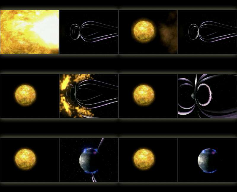
The movie above, and the solar flare video below, were released by the European Space Agency today, along with descriptions of two solar eruptions spotted using ESA’s four Cluster satellites and the two Chinese/ESA Double Star satellites. 

High-energy (X-3) solar flare on 13 December 2006. Credit: ESA/NASA/SOHO

Under normal solar conditions, satellites orbit within the magnetosphere — the protective magnetic bubble carved out by Earth’s magnetic field. But when solar activity increases, the picture changes significantly: the magnetosphere gets compressed and particles get energized, exposing satellites to higher doses of radiation that can perturb signal reception.

Scientists have found that extreme solar activity drastically compresses the magnetosphere and modifies the composition of ions in the near-Earth environment. They are now challenged to model how these changes affect orbiting satellites, including the GPS system.

During two extreme solar explosions, or solar flares, on January 21, 2005 and December 13, 2006, the Cluster constellation and the two Double Star satellites were favorably positioned to observe the events on a large scale. 

During both events, the velocity of positively charged particles in the solar wind was found to be higher than 900 km (559 miles) per second, more than twice their normal speed. In addition, the density of charged particles around Earth was recorded at five times higher than normal. The measurements taken in January 2005 also showed a drastic change in ion composition. 

The second explosion in December 2006 released extremely powerful high-energy X-rays followed by a huge amount of mass from the solar atmosphere (called a coronal mass ejection). During the event, GPS signal reception on ground was lost. 

Typical nose-like ion structures in near-Earth space were washed out as energetic particles were injected into the magnetosphere. These nose-like structures, that had formed earlier in the ‘ring current’ in the equatorial region near Earth, were detected simultaneously on opposite sides of Earth. Measurements of the ring current showed that its strength had increased. 

These factors together caused the magnetosphere to be compressed. Data show that the ‘nose’ of the dayside magnetopause (the outer boundary of the magnetosphere), usually located about 60,000 km (40,000 miles) from Earth, was only 25,000 km (15,000 miles) away.

About five hours after the coronal mass ejection hit Earth’s magnetosphere, a Double Star satellite observed penetrating solar energetic particles on the night side. These particles are hazardous to astronauts as well as satellites.

“With these detailed observations, we’ll be able to plug in data and better estimate what happens to the inner magnetosphere and near-Earth space during such explosions on the Sun,” said Iannis Dandouras, principal investigator of the Cluster Ion Spectrometer and lead author on a paper about the findings. 

“Looking at such a large-scale physical phenomena with a single satellite is akin to predicting the impact of a tsunami with a single buoy,” added Matt Taylor, ESA’s Project Scientist for Cluster and Double Star. “With Cluster and Double Star we have monitored both sides of Earth simultaneously, and obtained valuable in-situ data.”

The results appear in the February 2009) issue of Advances in Space Research. The abstract is available here.

Source: ESA

Submit Your Questions for Scott Parazynski and Keith Cowing

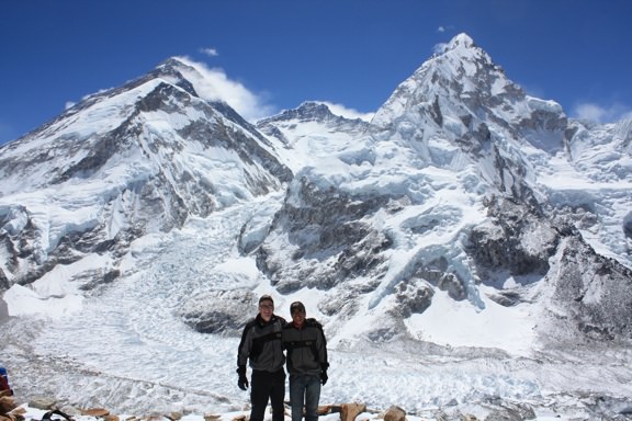
Scott and Danru on Pumor RI with Everest Behind Them. Credit: OnOrbit.com

[/caption]
Former astronaut Scott Parazynski is making an attempt to climb Mt. Everest, and has been sharing his adventures via Twitter, and his blog on OnOrbit.com. As we reported in in our article about Parazynski in March, he wants to share his experiences with as many people as possible. Earlier today, his “media sherpa,” Keith Cowing from NASA Watch.com joined Parazynski at base camp and both Cowing and Parazynski have agreed to take questions from readers of Universe Today and answer them during their time on Mt. Everest. Parazynski has been blogging and Twittering during his preparations for the climb, and he even wants to Twitter from the summit. “I want to tell the story of exploration here on Earth and the corollaries it has with space exploration,” Parazynski told Universe Today before he left for Kathmandu, Nepal. “The intent is to share the story with as many people as we can, particularly young people.”

So submit your questions in the comments section and we’ll relay them on. Questions can be about mountain climbing or space exploration.

For more information about check out Scott’s Twitter feed, and the OnOrbit blog, and you can even track Parazynski with his SPOT GPS locator system — which is kind of interesting to look at, as you can see how he has been going up and down the mountain the past couple of weeks to acclimate his body to higher elevation.

Despite Global Warming, Wildfire Frequency Does Not Increase

An Alaskan wildfire engulfs woodland (John McColgan/BLM Alaska Fire Service)

[/caption]

As global average temperatures rise, it is widely believed the frequency of wildfires will increase. However, this may not be the case. According to analysis of sediment from lake beds in Northern Alaska, the frequency of wildfires didn’t relate to changes in temperature variation over the last few thousand years. This is strange, surely a warmer climate will dry out vegetation faster, creating more fuel for fires to ignite and spread? Apparently not, there appears to be a far more potent controlling factor at play…

In Southern California, the temperatures easily hit 95°F (35°C) today and I noticed the entire neighbourhood pumping a small reservoir’s-worth of water into their manicured lawns (creating an impressive river down the street). Our garden looks a little dry in comparison, I refuse to turn the sprinklers on until we really need it (for now, the hose will do). Summer appears to have arrived early, making me slightly nervous; the wildfires that blighted this region over the the last few years are sure to return. To make matters worse, we had a surprisingly wet winter, helping the spring growth of vegetation. It may be nice and green now, but all I see is surplus firewood.

However, as the last few thousand years have shown us, no matter how hot it gets, the frequency of wildfires may actually decrease.

Using samples from sediment cores at the bottom of Alaskan lakes, climatologist Philip Higuera of Montana State University has discovered it could be the type of vegetation that grows in response to temperature increases that affects the frequency of subsequent wildfires. There is little indication to suggest the frequency of wildfires increased as global average temperatures increased over the past 15,000 years. This might be counter-intuitive, but it would appear nature has an automatic fire-retardation mechanism.

Climate is only one control of fire regimes, and if you only considered climate when predicting fire under climate-change scenarios, you would have a good chance of being wrong,” Higuera says. “You wouldn’t be wrong if vegetation didn’t change, but the greater the probability that vegetation will change, the more important it becomes when predicting future fire regimes.”

Using radiocarbon dating techniques, Higuera’s team were able to accurately date the different layers in the metre-long sediment samples. From there, they analysed the charcoal deposits, therefore deriving the wildfire frequency in North Alaska woodlands. In addition, they analysed pollen content to understand what species of plant were predominant over the past 15,000 years. Then, using known climate data for the same period, the researchers were able to correlate the fire frequency with plant species and then relate the whole lot with trends in climate change. The results are very interesting.

One of the key discoveries was that climate change a was less important factor than vegetation changes when related to frequency of wildfires. According to sediment samples over the millennia, despite very dry periods in climate history, wildfire frequency decreases sharply. It appears that during periods of temperature increases, vegetation species change from flammable shrubs to fire-resistant deciduous trees.

Climate affects vegetation, vegetation affects fire, and both fire and vegetation respond to climate change,” Higuera adds. “Most importantly, our work emphasizes the need to consider the multiple drivers of fire regimes when anticipating their response to climate change.”

Although we may not escape the clutches of wildfires in Southern California this year, the last 15,000 years have shown us that this may gradually change as vegetation adapts to hotter conditions, becoming more fire-resistant…

Source: Physorg.com

Where is the Most Remote Location on Earth?

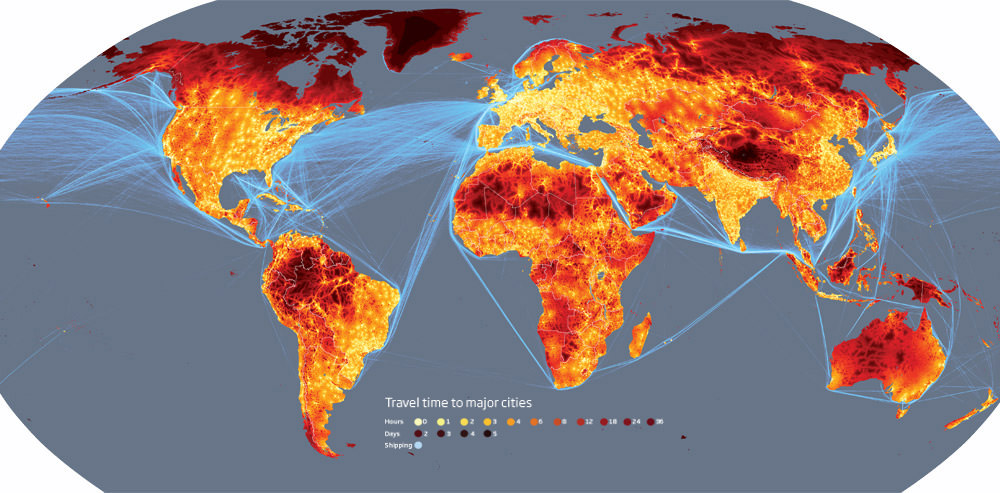
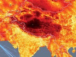
A heat map of travel-times to nearest city

[/caption]

According to a new study, less than 10% of the world’s land is more than 48 hours of travel from the nearest city. This doesn’t include air travel, it is ground-travel only (i.e. on foot, train, car, boat, bike, horse, donkey). So no matter where you are in the world, there’s a good chance you can get to somewhere substantially populated within two days. At face-value, this might not seem very important, but when you look at the maps, you see many wilderness locations aren’t quite as remote as we once thought they were. The Amazon Rainforest for example is surprisingly well connected (rivers are quite useful in that respect), and the remote deserts of Africa have a pretty efficient road network.

So, where is the most remote location on Earth? How long would it take to get there?

I can happily say that for 5 months I lived in one of the most remote places in the world. The Norwegian archipelago of Svalbard in the High Arctic turns out to be a very extreme place even if you put the polar bears and -30°C temperatures to one side. No matter how hard you try, it would take 2-3 days by boat to travel from Longyearbyen (on the main island of Spitsbergen) to the Norwegian mainland city of Tromsø. Unfortunately, the number of places around the globe that can boast this are rapidly shrinking.

The fact is, the travel time of any point from the nearest settlement of over 50,000 people using only ground-travel is decreasing rapidly. Transportation infrastructures are spreading and population density is increasing, meaning more people are making bigger cities closer together.

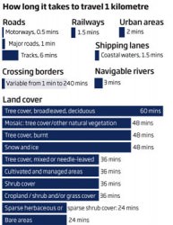
Travel times as used by the researchers
A new set of maps created by researchers at the European Commission’s Joint Research Centre in Ispra, Italy, and the World Bank illustrates just how “connected” our world has become and it also highlights the dwindling number of “true” wildernesses.

Based on a computer model that calculates the journey time to the nearest city of 50,000+ people taking only land or water. The variables included in this complex model are types of terrain, road, rail and river network access, altitude, terrain steepness and obstacles (such as border crossings). The key conclusions the researchers gained are that less than 10% of the planet’s landmass is more than 48 hours ground-travel away from the nearest city. The Amazon, for example, only has 20% of its landmass more than 2 days away from the nearest Brazilian city (owed primarily to its vast network of rivers).

The most striking maps include the plotting of the busiest waterways (the English Channel, Mediterranean and South China Seas are the most crowded) and the scope of the world’s road network. In fact, it is little wonder the international community is worried about the increasing numbers of Somalian pirate attacks; another very busy shipping lane is sandwiched between Somalia and Yemen (the key route from the Indian Ocean to the Mediterranean).

The most remot point on the entire planet: 34.7°N 85.7°E - the Tibeten plateau
The most remote point on the entire planet: 34.7°N 85.7°E - the Tibetan plateau
So where is the most remote place on Earth? The Tibetan plateau (pictured left). From 34.7°N 85.7°E, it would take three whole weeks to travel to the cities of Lhasa or Korla. If you were to take this trip, expect to walk for 20 days and drive by car for one day. Partly due to the rough terrain and 5200 metres in altitude, Tibet will probably remain the most extreme place on Earth for some time to come.

It is hoped these maps will serve as a baseline for future studies, showing how nations deal with population growth, how nature is being eroded and possibly providing some insight as to how to manage the planet a little better than we are at present…

View all the maps »

Source: New Scientist

A Day for Earth, but a Whole Week for Dark Skies

[/caption]

Wednesday is Earth Day, but all week — Monday, April 20 through Saturday, April 26 — is National Dark Sky Week in America, when people are asked to dim the lights to see more stars.

If enough people participate, backyard and professional astronomers might be treated with a week of darker, starrier skies. The bigger idea is to raise awareness about sensible lighting practices, so skies might get a little bit darker all the time. And not just for astronomy buffs. Besides aesthetics, evidence is mounting that light pollution could have far-reaching effects for the environment and even public health.

milky-way
360-degree panoramic picture of the Milky Way as seen from Death Valley. Credit: Dan Duriscoe, National Park Service.

Jennifer Barlow, founder of the event, said the only way National Dark Sky Week can succeed is if more people participate every year. “No reduction in light pollution can be made unless a significant number of people turn off their lights,” she said.

Besides turning out the lights, the participating groups are encouraging people to attend star parties, visit local observatories, or “dust off the old telescope from the attic,” Barlow said.

Year-round, the International Dark Sky Association encourages people to shield lights, or use fixtures that focus light downward instead of up into the sky. Reducing extraneous light, especially at ball fields, is a major step in the right direction. And certain types of lighting — like low-pressure sodium — are better than others.

Flagstaff, Arizona became the world’s first International Dark-Sky City in 2001, owing to the presence of several important observatories — it’s the home of Lowell Observatory and the U.S. Naval Observatory — along with the dedicated efforts of a handful of astronomers. The city government and the vast majority of businesses have readily complied with responsible lighting codes to protect views of the night sky for residents and astronomers alike. 

The skies are noticeably dark over Flagstaff; the stars are rich at night. The Grand Canyon is even more impressive, especially on the north side. The views after dark are as stunning and magical as those during  the day.

But even those skies aren’t as good as they could be, because light pollution from cities up to 200 miles away — including Las Vegas and Phoenix — is gradually creeping in. Chad Moore, a dark skies advocate who works for the National Park Service in Denver, has spent nearly a decade documenting the skies over 55 of the nation’s parks, which are usually the best places to see stars.

Parts of rare parks — Capitol Reef, Great Basin and Big Bend among them — boast truly dark skies, he said.

Moore pointed out there are reasons besides beauty to rein in light pollution: “In the last 10 years there has been a revolution in our understanding of animal habitat and what animals require,” he said. “There are links between artificial light and cancer in humans. There’s a lot we didn’t know about.”

Second photo caption: 360-degree panoramic picture of the Milky Way as seen from Death Valley. Credit: Dan Duriscoe, National Park Service.

For more information:

National Dark Sky Week 
International Dark-Sky Association
IYA Dark Skies Awareness
Starlight Initiative
World Night in Defense of Starlight
American Astronomical Society
Astronomical League
NASA IYA site


Major Utility Company Makes Agreement for Space Based Solar Power

Solar Collecting Satellite. Image courtesy of Mafic Studios.

[/caption]
One of the largest utility companies in the US has decided to look towards space to find more power. Pacific Gas and Electric (PG&E) in California announced a proposed agreement with startup company Solaren Corporation to provide 200 mega watts of space based solar power (SBSP) starting in 2016. PG&E is now seeking approval from California state regulators for permission to sign this agreement. While PG&E is not making any financial investment at this time, the announcement shows that SBSP is being taken seriously as a viable energy source. PG&E and the two other California utilities are required by the state to source 20 percent of their power from renewable sources by 2010 and 30 percent by 2017. None are producing the required amount so far.

Solaren Corporation is a small, 8-year-old company based in California whose executives have experience working for Boeing and Lockheed Martin. According to PG&E’s website, Solaren says it plans to generate the power using solar panels in earth orbit, then convert it to radio frequency energy for transmission to a receiving station in California. From there, the energy will be converted to electricity and fed into PG&E’s power grid

The proposed agreement is for the delivery of 200MW starting in 2016 for 15 years.

Earlier this year Universe Today interviewed Peter Sage from Space Energy, another SBSP company. Sage said in a statement released today that this announcement is a
“huge step forward for both Solaren and Space Energy as it highlights to the investment community that utility firms are willing to recognize Space-Based Solar Power as a credible and viable source of energy.” Sage added that while the 200 mega watts Solaren is planning to provide represents only 20% of the planned capacity of one of Space Energy’s satellites, it successfully validates the overall business case for SBSP within the larger energy industry.

The U.S. Department of Energy and NASA began seriously studying the concept of solar power satellites in the 1970s, again in the 1990’s and in 2007, a major study by the Defense Department’s National Security Space Office gave the concept another boost, concluding that “there is enormous potential for energy security, economic development, improved environmental stewardship … and overall national security for those nations who construct and possess a SBSP capability.”

It seems like a win-win situation for PG&E. They told their customers, “If Solaren succeeds, PG&E’s customers have a great opportunity to benefit from affordable clean energy. There is no risk to PG&E customers; PG&E has contracted only to pay for power that Solaren delivers.”

PG&E has 5.1 million electric customer accounts and 4.2 million natural-gas customer accounts in Northern and Central California.

Sources: Space Energy press release, PG&E website

Without Nickel, Life on Earth Could Finally Breathe

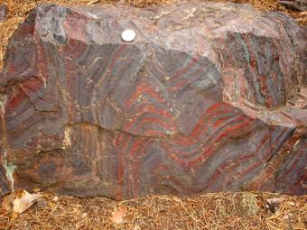
Caption: Banded iron formations like this from northern Michigan contain evidence of a drop in dissolved nickel in ancient oceans. Credit: Carnegie Institution for Science

[/caption]
Researchers have long puzzled over why oxygen flourished in Earth’s atmosphere starting around 2.4 billion years.

Called the “Great Oxidation Event,” the transition “irreversibly changed surface environments on Earth and ultimately made advanced life possible,” said Dominic Papineau of the Carnegie Institution’s Geophysical Laboratory.

Now, Papineau has co-authored a new study in the journal Nature,  which reveals new clues to the mystery in ancient sedimentary rocks.

The research team, led by Kurt Konhauser of the University of Alberta in Edmonton, analyzed the trace element composition of sedimentary rocks known as banded-iron formations, or BIFs, from dozens of different localities around the world, ranging in age from 3,800 to 550 million years. Banded iron formations are unique, water-laid deposits often found in extremely old rock strata that formed before the atmosphere or oceans contained abundant oxygen. As their name implies, they are made of alternating bands of iron and silicate minerals.

They also contain minor amounts of nickel and other trace elements. And the history of nickel, the researchers think, may reveal a secret to the origin of modern life.

Nickel exists in today’s oceans in trace amounts, but was up to 400 times more abundant in the Earth’s primordial oceans. Methane-producing microorganisms, called methanogens, thrive in such environments, and the methane they released to the atmosphere might have prevented the buildup of oxygen gas, which would have reacted with the methane to produce carbon dioxide and water.

A drop in nickel concentration would have led to a “nickel famine” for the methanogens, who rely on nickel-based enzymes for key metabolic processes. Algae and other organisms that release oxygen during photosynthesis use different enzymes, and so would have been less affected by the nickel famine. As a result, atmospheric methane would have declined, and the conditions for the rise of oxygen would have been set in place.

The researchers found that nickel levels in the BIFs began dropping around 2.7 billion years ago and by 2.5 billion years ago was about half its earlier value.

“The timing fits very well. The drop in nickel could have set the stage for the Great Oxidation Event,” Papineau said. “And from what we know about living methanogens, lower levels of nickel would have severely cut back methane production.”

As for why nickel dropped in the first place, the researchers point to geology. During earlier phases of the Earth’s history, while its mantle was extremely hot, lavas from volcanic eruptions would have been relatively high in nickel. Erosion would have washed the nickel into the sea, keeping levels high. But as the mantle cooled, and the chemistry of lavas changed, volcanoes spewed out less nickel, and less would have found its way to the sea.

“The nickel connection was not something anyone had considered before,” Papineau said. “It’s just a trace element in seawater, but our study indicates that it may have had a huge impact on the Earth’s environment and on the history of life.”

Source: Carnegie Institution for Science, via Eurekalert.

Was the Tunguska Fireball a Comet Chemical Bomb?

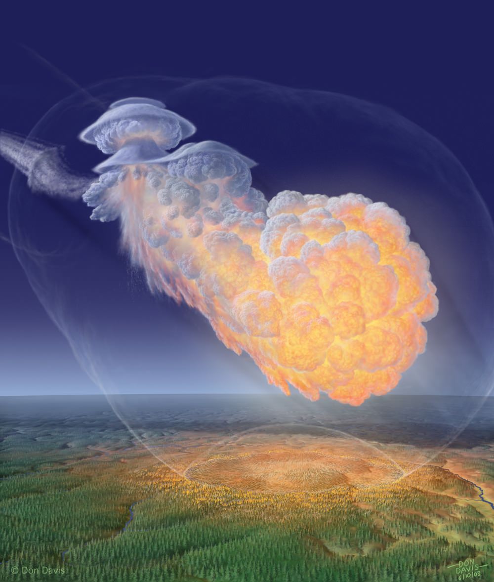
It was an energetic event that occurred over Tunguska, but what caused it? (Don Davis)

[/caption]Over a century ago, on June 30th, 1908 a huge explosion detonated over an unpopulated region of Russia called Tunguska. It is probably one of the most enduring mysteries of this planet. What could cause such a huge explosion in the atmosphere, with the energy of a thousand Hiroshima atomic bombs, flattening a forest the area of Luxembourg and yet leaving no crater? It is little wonder that the Tunguska event has become great material for science fiction writers; how could such a huge blast, that shook the Earth’s magnetic field and lit up the Northern Hemisphere skies for three days leave no crater and just a bunch of flattened, scorched trees?

Although there are many theories as to how the Tunguska event may have unfolded, scientists are still divided over what kind of object could have hit the Earth from space. Now a Russian scientist believes he has uncovered the best answer yet. The Earth was glanced by a large comet, that skipped off the upper atmosphere, dropping a chunk of comet material as it did so. As the comet chunk heated up as it dropped through the atmosphere, the material, packed with volatile chemicals, exploded as the biggest chemical explosion mankind had ever seen…

12,000 years ago, a large object smashed into North America, causing global destruction. Dust and ash was released into the atmosphere, triggering global cooling and possibly causing the extinction of a number of large mammals around this time. The Tunguska event was of a similar energy to that catastrophic impact, but fortunately for us, Tunguska had a benign effect on the world. It simply exploded high in the atmosphere, flattened a region of Russia and vaporized.

Significantly, the energy of the chemical explosion is substantially lower than the kinetic energy of the body,” says Edward Drobyshevski of the Russian Academy of Sciences in St Petersburg, who has published his research into the Tunguska event. The fact that the Tunguska explosion energy is lower than what is expected of the kinetic energy of an object that hit the Earth from space is key to his work. Drobyshevski therefore concludes that the event must have been caused not by an asteroid or whole comet, it was actually caused by a fragment of comet material that fell off as the main cometary body skipped off the Earth’s upper atmosphere. This means that the Earth was hit on a tangent and the fragment dropped comparatively slowly toward the surface.

Sounds reasonable so far, but how did the fragment explode? Using our new understanding as to what chemicals comets contain, Drobyshevski surmises the fragment was rich in hydrogen peroxide. This is where the magic happened. The explosion was not due to a rapid release of kinetic energy, it was in fact a hydrogen peroxide bomb. As the fragment descended, it heated up. As the reactive chemicals in the material got hot, they explosively disassociated to form oxygen and water, ripping the fragment apart. The Tunguska event was therefore a huge chemical bomb and not a “regular” comet-hits-Earth impact.

An interesting study. Not content with dropping asteroids on our planet, the Universe has started throwing hydrogen peroxide explosives at us too. Whatever next?

Source: The Physics arXiv Blog

Countdown to Earth Hour 2009…


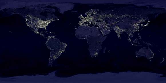
There’s less than 24 hours left before Earth Hour 2009 will begin. While you may hotly debate whether or not turning out your lights for one hour can impact our global climate – it’s not about what actually happens to our planet during that hour, but about showing you care. 3,900 cities and towns in 84 countries around the world will be shutting down the lights at 8:30 pm local time in one of the biggest events in history. Even if you don’t care, take the time to read just a little bit more… Where will you be when the lights go out?

According the latest Earth Hour bulletin: “More than 300 cities and towns in the U.S. representing 43 states and the District of Columbia are going dark as part of the largest global climate event in history. Before the rooster crows in most American cities on Saturday morning, lights will already have gone dark in cities like Christchurch, Sydney and Brisbane. By breakfast time on the U.S. East Coast, the cities of Beijing, Kuala Lumpur, Jakarta, Singapore and Manila will be celebrating the arrival of the largest global climate event in history. Just before lunchtime in America, the lights will be dimming in Mumbai, Amman and Dubai. And by early afternoon in New York, it will be lights out in Paris, Istanbul, London and Copenhagen.”

Can you imagine places that you would never dream of going dark participating in such an event? During Earth Hour you’ll find The European Union Headquarters in Brussels, St. Peter’s Basilica in Vatican City, Bird’s Nest Olympic Stadium in Beijing, Washington, D.C, The Pyramids in Egypt, the Acropolis in Athens, the Broadway Theater District, the Space Needle in Seattle, and the Chrysler Building will all go dark for Earth Hour.

Read the Earth Hour Mission: “For the first time in history, people of all ages, nationalities, race and background have the opportunity to use their light switch as their vote – Switching off your lights is a vote for Earth, or leaving them on is a vote for global warming. WWF are urging the world to VOTE EARTH and reach the target of 1 billion votes, which will be presented to world leaders at the Global Climate Change Conference in Copenhagen 2009.

This meeting will determine official government policies to take action against global warming, which will replace the Kyoto Protocol. It is the chance for the people of the world to make their voice heard. We all have a vote, and every single vote counts. Together we can take control of the future of our planet, for future generations.”

VOTE EARTH by simply switching off your lights for one hour, and join the world for Earth Hour – Saturday, March 28, 8:30-9:30pm.

With much love to all of those who took the time to care and spread the word. Special thanks to Kim B. for all of her hard work in promoting Earth Hour!

Redoubt Re-ignites

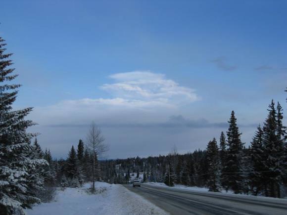
An ash cloud looms in the distance near Kachemak Bay Bluffs. Credit: Steve Baird, AVO

[/caption]
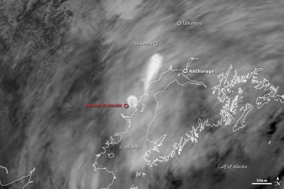
Alaska’s Mount Redoubt erupted twice Thursday morning, creating a 12-mile-high cloud of ash. The Alaska Volcano Observatory reported the first eruption came about 8:30 a.m., sending an ash cloud more than 9,100 meters (30,000) feet in the air. A second eruption came about an hour later, and blasted ash 20,000 meters (65,000 feet) high. After the second eruption, mud flows called lahars near the base of the volcano ran into the nearby Drift River. The National Weather Service also issued a flash flood warning for regions surrounding the Drift River, as eruptions can cause snow and ice to melt, causing the river to swell with melt water. The ash is predicted to drift as far as Anchorage, which lies about 160 km (100 miles) northeast of the volcano.

Redoubt ash plume. NASA images created by Jesse Allen, using data provided courtesy of the MODIS Rapid Response team

The volcano erupted with five smaller blasts on Monday, but had been relatively quiet for the past two days. Since the earlier eruptions occurred during the night, satellite images were not available during the peak times of eruptions, but scientists are hoping satellites were able to capture the latest eruptions in action.

Airlines have canceled flights around the area, as ash poses a significant threat to aircraft engines. Some regions surrounding Mount Redoubt have been evacuated.

Geologists with the U.S. Geological Survey have said a lot of snow and ice remains on the mountain, increasing the danger from mud flows that already have downed hundreds of trees and carved a huge gouge out of a glacier.

AVO, NASA Earth Observatory, Yahoo News