The Northern and Southern Lights – What is an Aurora?

An aurora seen over the South Pole, from the ISS. Credit: Doug Wheelock, NASA.

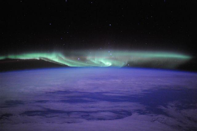
For many people around the world the ability to see the Aurora Borealis or Aurora Australis is a rare treat. Unless you live north of 60° latitude (or south of -60°), or who have made the trip to tip of Chile or the Arctic Circle at least once in their lives, these fantastic light shows are something you’ve likely only read about or seen a video of.

But on occasion, the “northern” and “southern lights” have reached beyond the Arctic and Antarctic Circles and dazzled people with their stunning luminescence. But what exactly are they? To put it simply, auroras are natural light displays that take place in the night sky, particularly in the Polar Regions, and which are the result of interaction in the ionosphere between the sun’s rays and Earth’s magnetic field.

Description:

Basically, solar wind is periodically launched by the sun which contains clouds of plasma, charged particles that include electrons and positive ions. When they reach the Earth, they interact with the Earth’s magnetic field, which excites oxygen and nitrogen in the Earth’s upper atmosphere. During this process, ionized nitrogen atoms regain an electron, and oxygen and nitrogen atoms return from an excited state to ground state.

High-speed particles from the Sun, mostly electrons, strike oxygen and nitrogen atoms in Earth's upper atmosphere. Credit: NASA
High-speed particles from the Sun, mostly electrons, strike oxygen and nitrogen atoms in Earth’s upper atmosphere. Credit: NASA

Excitation energy is lost by the emission of a photon of light, or by collision with another atom or molecule. Different gases produce different colors of light – light emissions coming from oxygen atoms as they interact with solar radiation appear green or brownish-red, while the interaction of nitrogen atoms cause light to be emitted that appears blue or red.

This dancing display of colors is what gives the Aurora its renowned beauty and sense of mystery. In northern latitudes, the effect is known as the Aurora Borealis, named after the Roman Goddess of the dawn (Aurora) and the Greek name for the north wind (Boreas). It was the French scientist Pierre Gassendi who gave them this name after first seeing them in 1621.

In the southern latitudes, it is known as Aurora Australis, Australis being the Latin word for “of the south”. Auroras seen near the magnetic pole may be high overhead, but from farther away, they illuminate the northern horizon as a greenish glow or sometimes a faint red. The auroras are usually best seen in the Arctic and Antarctic because that is the location of the poles of the Earth’s magnetic field.

The South Pole Telescope under the aurora australis (southern lights). Photo by Keith Vanderlinde
The South Pole Telescope under the aurora australis (southern lights). Credit: Keith Vanderlinde

Names and Cultural Significance:

The northern lights have had a number of names throughout history and a great deal of significance to a number of cultures. The Cree call this phenomenon the “Dance of the Spirits”, believing that the effect signaled the return of their ancestors.

To the Inuit, it was believed that the spirits were those of animals. Some even believed that as the auroras danced closer to those who were watching them, that they would be enveloped and taken away to the heavens. In Europe, in the Middle Ages, the auroras were commonly believed to be a sign from God.

According to the Norwegian chronicle Konungs Skuggsjá (ca. 1230 CE), the first encounter of the norðrljós (Old Norse for “northern light”) amongst the Norsemen came from Vikings returning from Greenland. The chronicler gives three possible explanations for this phenomena, which included the ocean being surrounded by vast fires, that the sun flares reached around the world to its night side, or that the glaciers could store energy so that they eventually glowed a fluorescent color.

Auroras on Other Planets:

However, Earth is not the only planet in the Solar System that experiences this phenomena. They have been spotted on other Solar planets, and are most visible closer to the poles due to the longer periods of darkness and the magnetic field.

Saturn Aurora
Image of Saturn’s aurora taken by the Huddle Space Telescope and seen in ultraviolet wavelengths. Credit: ESA/NASA/Hubble

For example. the Hubble Space Telescope has observed auroras on both Jupiter and Saturn – both of which have magnetic fields much stronger than Earth’s and extensive radiation belts. Uranus and Neptune have also been observed to have auroras which, same as Earth, appear to be powered by solar wind.

Auroras also have been observed on the surfaces of Io, Europa, and Ganymede using the Hubble Space Telescope, not to mention Venus and Mars. Because Venus has no planetary magnetic field, Venusian auroras appear as bright and diffuse patches of varying shape and intensity, sometimes distributed across the full planetary disc.

An aurora was also detected on Mars on August 14th, 2004, by the SPICAM instrument aboard Mars Express. This aurora was located at Terra Cimmeria, in the region of 177° East, 52° South, and was estimated to be quite sizable – 30 km across and 8 km high (18.5 miles across and 5 miles high).

Mars has magnetized rocks in its crust that create localized, patchy magnetic fields (left). In the illustration at right, we see how those fields extend into space above the rocks. At their tops, auroras can form. Credit: NASA

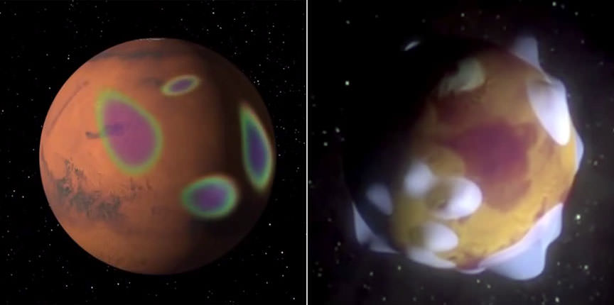
Though Mars has little magnetosphere to speak of, scientists determined that the region of the emissions corresponded to an area where the strongest magnetic field is localized on the planet. This they concluded by analyzing a map of crustal magnetic anomalies compiled with data from Mars Global Surveyor.

More recently, an aurora was observed on Mars by the MAVEN mission, which captured images of the event on March 17th, 2015, just a day after an aurora was observed here on Earth. Nicknamed Mars’ “Christmas lights”, they were observed across the planet’s mid-northern latitudes and (owing to the lack of oxygen and nitrogen in Mars’ atmosphere) were likely a faint glow compared to Earth’s more vibrant display.

In short, it seems that auroras are destined to happen wherever solar winds and magnetic fields coincide. But somehow, knowing this does not make them any less impressive, or diminish the power they have to inspire wonder and amazement in all those that behold them.

We have written many articles about Aurorae here at Universe Today. Here’s What is the Aurora Borealis?, What is the Aurora Australis?, What Causes an Aurora?, Your Guide to When, Where, and How to see the Aurora Borealis, Northern and Southern Lights are Siblings, not Twins.

and See the Latest Jaw-Dropping Aurora Views from the ISS.

If you’d like more info on the aurora, check out Space Weather Center, and here’s a link to some amazing Aurora Borealis pictures taken from Alaska.

We’ve also recorded an episode of Astronomy Cast all about Aurora. Listen here, Episode 163: Auroras.

Sources:

What Is the Coriolis Effect

Coriolis Effect
Coriolis Effect

[/caption]

The Coriolis effect is one of those terms that you hear used from time to time, but it never seems to get fully explained, so you are left wondering ‘what is the Coriolis effect?’ The Coriolis effect is the apparent curvature of global winds, ocean currents, and everything else that moves freely across the Earth’s surface. The curvature is due to the rotation of the Earth on its axis. The effect was discovered by the nineteenth century French engineer Gaspard C. Coriolis. He used mathematical formulas to explain that the path of any object set in motion above a rotating surface will curve in relation to objects on that surface.

If not for the Earth’s rotation, global winds would blow in straight north-south lines. What actually happens is that global winds blow diagonally. The Coriolis effect influences wind direction around the world in this way: in the Northern Hemisphere it curves winds to the right; in the Southern Hemisphere it curves them left. The exception is with low pressure systems. In these systems there is a balance between the Coriolis effect and the pressure gradient force and the winds flow in reverse.

Satellites appear to follow curved paths when plotted on world maps because the Earth is a sphere and the shortest distance between two points on a sphere is not a straight line. Two-dimensional maps distort a three-dimensional surface in some way. The distortion increases with closer to the poles. In the northern hemisphere a satellite’s orbit using the shortest possible route will appear to follow a path north of the straight line from beginning to end, and then curve back toward the equator. This occurs because the latitudes, which are projected as straight horizontal lines on most world maps, are in fact circles on the surface of a sphere, which get smaller as they get closer to the pole. This happens simply because the Earth is a sphere and would be true if the Earth didn’t rotate. The Coriolis effect is of course also present, but its effect on the plotted path is much smaller, but increases in importance when calculating a trajectory or end destination. The effect becomes very important when you need to plot trajectories for missiles or artillery fire.

To sum up ‘what is the Coriolis effect’, it is an important meteorological force that is used to predict the path of storms and explains why a projectile will not hit a target at a great distance if the Earth’s rotation is not accounted for.

We have written many articles about Coriolis Effect for Universe Today. Here’s an article about the hurricane, and here’s an article about the Earth’s rotation.

If you’d like more info on Coriolis Effect, check out NASA’s Solar System Exploration Guide on Earth. And here’s a link to NASA’s Earth Observatory.

We’ve also recorded an episode of Astronomy Cast all about planet Earth. Listen here, Episode 51: Earth.

Sources:
University of Oregon
Wikipedia
NASA

What is the Bakken Formation?

The extent of the Bakken Formation, a subsurface formation within the Williston Basin. Credit:

There has certainly been a lot of talk over the past few decades about this thing known as the “energy crisis”. In essence, we’re being told that fossil fuels are running low, that we need to start thinking green and about alternative fuels and renewable resources.

However, there’s also been a lot of discussion about places like Alberta Tar Sands and other North American oil deposits, and how these might meet our energy needs for the foreseeable future. One such deposit is the Bakken Formation, a rock unit occupying about 520,000 km² (200773 square miles) of the Williston Basin, which sits beneath parts of Saskatchewan, Manitoba, Montana, and North Dakota.

On the geologic timescale, the rock formation is believed to date from the late Devonian to Early Mississippian age – from roughly 416 to 360 million years ago. It was discovered in 1953 by a geologist named J.W. Nordquist and named after Henry Bakken, owner of the Montana farm where Nordquist first drilled.

Schematic north-south cross section showing the Bakken and adjacent formations in 2013. Credit: USGS

This rock formation consists of three members or strata: the lower shale, middle dolomite, and upper shale. Oil was first discovered there in 1951, but pumping it met with difficulties. This is due to the fact that the oil itself is principally found in the middle dolomite member – roughly 3.2 km (two miles) below the surface – where it is trapped in layers of non-porous shale, making the process both difficult and expensive.

While it was postulated as early as 1974 that the Bakken could contain vast amounts of petroleum, it wasn’t until Denver-based geologist Leigh Price did a field assessment for the U.S. Geological Survey (USGS) in 1995 that official estimates were made. Price estimated in 1999 that the Bakken Formation contained between 271 and 503 billion barrels of petroleum.

Impressive, yes? Well, keep in mind that the percentage of this oil that could actually be extracted is debatable. In 1994, estimates ranged from as low as 1% to Price’s estimate of 50%. A more recent report filed in 2008 by the USGS placed the amount at between 3.0 to 4.3 billion barrels (680,000,000 m3), with a mean of 3.65 billion.

Number of Bakken and Three Forks wells in the US as of 2013. Credit: energy.usgs.gov

By 2011, a senior manager at Continental Resources Inc. (CLR) raised that estimate to an overall at 24 billion barrels, claiming that the “Bakken play in the Williston basin could become the world’s largest discovery in the last 30–40 years”.

But reports issued by both the USGS and the state of North Dakota in April 2013 were more conservative, estimating that up to 7.4 billion barrels of oil could be recovered from the Bakken and Three Forks formations using current technology.

Still, this represents a significant increase from the estimates made back in 1995. Horizontal well and hydraulic fracturing technology have helped, adding about 70 million barrels of production in 7 years in Montana and North Dakota. By 2007, Saskatchewan was also experiencing a boom, producing five million barrels in that year, which was up 278,540 barrels in 2004.

Consistent with the US’ policy of achieving “energy independence”, analyst expect that an additional $16 billion will be spent to further develop the Bakken fields in 2015. The large increase in tight oil production is one of the reasons behind the price drop in late 2014, and keeping prices low is always politically popular.

North Dakota oil production. Credit: eia.gov
The North Dakota “oil boom”, represented by the state’s production per month and year. Credit: eia.gov

As more wells are brought online, production will continue to increase in places like North Dakota. While the rate of production per well appears to have peaked at 145 barrels a day since June of 2010, the number of wells has also doubled in the region between then and December of 2011.

The increase in oil and natural gas extraction has also had a profound increase on the economy of North Dakota. In addition to leading a reduction in unemployment, it has given the state a billion-dollar budget surplus and a GDP that is 29% above the national average. However, there has also been the resulting rise in pollution and the strain that industrialization and a population surge has put on the states’ water supply.

Will any of this solve the “energy crisis”? Hard to say. Because of the highly variable nature of shale reservoirs and shale drilling, and the fact that per-well rates seem to have peaked, it seems unlikely that total Bakken production will grow much further or affect the imports of foreign oil.

And given how the price of alternatives like solar, wind, geothermal and tidal energy are dropping all the time, one can expect that a fossil fuel-economy will become something of a fossil itself someday!

We have written many articles about the Bakken Formation for Universe Today. Here’s an article about Alternative Energy Sources, and here’s an article about harvesting solar power from space.

If you’d like more info on the Bakken Formation, check out the U.S. Geological Survey Homepage. And here’s a link to NASA’s Earth Observatory.

We’ve also recorded an episode of Astronomy Cast all about planet Earth. Listen here, Episode 51: Earth.

Sources:
http://en.wikipedia.org/wiki/Bakken_Formation – cite_note-usgs.gov-3
http://www.cbc.ca/money/story/2008/05/23/f-langton-bakken.html
http://www.theoildrum.com/node/3868
http://www.thestar.com/Business/article/414164

What is an Avalanche?

A powder snow avalanche in the Himalayas near Mount Everest. Credit: Wikipeida Commons/ Ilan Adler

Have you ever noticed how the snow packs on a car windshield after a heavy snowfall? While the temperature is cold, the snow sticks to the surface and doesn’t slide off. After temperatures warm up a little, however, the snow will slide down the front of the windshield, often in small slabs. This is an avalanche on a miniature scale.

On the other hand, a mountain avalanche in North America might release 229,365 cubic meters (300,000 cubic yards) of snow. That’s the equivalent of 20 football fields filled 10 feet deep with snow. However, such large avalanches are often naturally released. They are primarily composed of flowing snow but given their power, they are also capable of carrying rocks, trees, and other forms of debris with them.

In mountainous terrain avalanches are among the most serious objective hazards to life and property, with their destructive capability resulting from their potential to carry an enormous mass of snow rapidly over large distances.

Classification:

Avalanches are classified based on their form and structure, which are also known as “morphological characteristics”. Some of the characteristics include the type of snow involved, the nature of what caused the structural failure, the sliding surface, the propagation mechanism of the failure, the trigger of the avalanche, the slope angle, direction, and elevation.

Loose snow avalanches (far left) and slab avalanches (near center) near Mount Shuksan in the North Cascades mountains. Credit: wikipedia
Loose snow avalanches (far left) and slab avalanches (near center) near Mount Shuksan in the North Cascades mountains. Credit: Thermodynamic/Wikipedia Commons

All avalanches are rated by either their destructive potential or the mass they carry. While this varies depending on the geographical region – – all share certain common characteristics, ranging from small slides (or sluffs) that pose a low risk to massive slides that come that pose a significant risk.

An avalanche has three main parts: the starting zone, the avalanche track, and the runout zone. The starting zone is the most volatile area of a slope, where unstable snow can fracture from the surrounding snowcover and begin to slide. The avalanche track is the path or channel that an avalanche follows as it goes downhill. The runout zone is where the snow and debris finally come to a stop.

Causes:

Several factors may affect the likelihood of an avalanche, including weather, temperature, slope steepness, slope orientation (whether the slope is facing north or south), wind direction, terrain, vegetation, and general snowpack conditions. However, weather remains the most likely factor in triggering an avalanche.

During the day, as temperatures increase in a mountainous region, the likelihood of an avalanche increases. Regardless of the time of year, an avalanches will only occur when the stress on the snow exceeds the strength either within the snow itself or at the contact point where the snow pack meets the ground or the rock surface.

An avalanche east of Revelstoke in 2010 Credit: Canadian Avalanche Center
An avalanche east of the town of Revelstoke, BC, in 2010 Credit: Canadian Avalanche Center

Although avalanches can occur on any slope given the right conditions, in North America certain times of the year and certain locations are naturally more dangerous than others. Wintertime, particularly from December to April, is when most avalanches will occur with the highest number of fatalities occurs in January, February and March, when the snowfall amounts are highest in most mountain areas.

Deaths Caused by Avalanches:

In the United States, 514 avalanche fatalities have been reported in 15 states from 1950 to 1997. In the 2002–2003 season there were 54 recorded incidents in North America involving 151 people.

In Canada’s mountainous province of British Columbia, a total of 192 avalanche-related deaths were reported between January 1st, 1996 and March 17th, 2014 – an average of roughly ten deaths per year. During the winter of 2014, avalanche concerns also forced the closure of the Trans-Canada highway on a number of occasions.

Avalanches on Other Planets:

Not too surprisingly, Earth is not the only planet in the Solar System to experience avalanches. Wherever their is mountainous terrain and water ice, which is not uncommon, there is the likelihood that material will come loose and cause a cascading slide to take place.

On February 19th, 2008, NASA’s Mars Reconnaissance Orbiter captured the first ever image of active avalanches taking place the Red Planet. The avalanche occurred near the north pole, where water ice exists in abundance, and was captured by the MRO’s HiRISE (High Resolution Imaging Experiment) camera completely by accident.

Images taken by the MRO's HiRISE camera show at least four Martian avalanches, or debris falls, taking place near the north pole. Credit: NASA/JPL
Images taken by the MRO’s HiRISE camera show at least four Martian avalanches, or debris falls, taking place near the north pole. Credit: NASA/JPL

The images showed material – likely to include fine-grained ice dust and possibly large blocks – detaching from a towering cliff and cascading to the gentler slops below. The occurrence of the avalanches was spectacularly revealed by the accompanying clouds of fine material (visible in the photographs) that continue to settle out of the air.

The largest cloud (shown in the upper images) was about 180 meters (590 feet) across and extended about 190 meters (625 feet) from the base of the steep cliff. Shadows to the lower left of each cloud illustrate further that these are three dimensional features hanging in the air in front of the cliff face, and not markings on the ground.

The photo was unprecedented because it allowed NASA scientists to get a glimpse of a dramatic change on the Martian surface while it was happening. Despite seeing countless pictures that have detailed the planet’s geological features, most appear to have remained unchanged for several million years. It also showed that terrestrial events like avalanches are not confined to planet Earth.

We have written many articles about the avalanche for Universe Today. Here’s an article about the Mars avalanche predicted by geologists, and here’s an article about the volcanic tuff.

If you’d like more info on avalanche, check out NASA Science News: Avalanche on Mars. And here’s a link to the American Avalanche Association Homepage.

We’ve also recorded an episode of Astronomy Cast all about planet Earth. Listen here, Episode 51: Earth.

Sources:

Equator

GOES-8 Satellite Image Captures Earth

[/caption]

An equator is an imaginary line that runs around the surface of a planet, perpendicular to the sphere’s axis of rotation. Of course, the one we’re most interested in is the Earth’s equator. Regions north of the equator are called the Northern Hemisphere, and then south of the equator is the Southern Hemisphere.

Here on Earth, the equator has a length of 40,008.6 kilometers, and its latitude is 0°. And if you can stand on the equator, you’ll see the Sun rise in the East and travel overhead through the day, and then set in the West; on the March and September equinox, the rays from the Sun fall straight down. This is also the spot with the quickest sunrise and sunset times, since the Sun moves exactly perpendicular to the horizon, rising straight up, without moving at an angle to the horizon.

Because the Earth is rotating, turning once a day on its axis, the Earth’s equator bulges out further from the center than from the poles. The Earth isn’t a sphere, but it’s actually an oblate spheroid. The equatorial diameter of the Earth is actually 43 kilometers greater than the polar diameter.

Since it’s the region of Earth that receives the most sunlight, the climate near the equator is hot – it’s summer all the time. People who live near the equator will generally distinguish between a long hot dry season and a long hot wet season. Some of the countries with the equator include Gabon, Congo, Uganda, Kenya, Somalia, Indonesia, Ecuador, Columbia, and Brazil.

The equator is the best place to launch a spacecraft on Earth. That’s because the rotational speed of the planet adds to the launch velocity of a rocket. Rockets launched from the equator can launch with less fuel, or carry more mass into orbit with the same amount of fuel. This is why the Guiana Space Centre is located in Kourou, French Guiana. And this is also why the Sea Launch platform travels from Los Angeles down to the equator before launching rockets.

We have written many articles about the Equator for Universe Today. Here’s an article about the temperature of the Earth, and here’s an article about the circumference of the Earth.

If you’d like more info on Equator, check out NASA’s Article about Latitude and Longitude. And here’s a link to NASA’s Earth Observatory.

We’ve also recorded an episode of Astronomy Cast all about planet Earth. Listen here, Episode 51: Earth.

Source: Wikipedia

Bedrock

Soil Layers Image Credit: Discovery

[/caption]

As you probably know, the Earth is comprised of layers. At the center of the Earth is the molten metal core, surrounded by the rocky mantle and then the outer crust. This outer crust is mostly comprised of rock, with a thin layer of soil, sand and loose material on top of it. The point where the rock is still a solid mass is called the bedrock. In many situations, the bedrock layer is many meters down, but in places where there’s erosion, the bedrock can be exposed to the air, so you can study it.

Geologists use bedrock as a kind of book, to study the history of a region of the Earth. The kind of rock that was deposited, or how it has been weathered tells geologists a lot about what processes happened to create this area. They can see how the bedrock was tilted through plate tectonics, or the chemical constituents of the lava that formed the original rock, or what kinds of process occurred in the area since the rock originally formed.

The depth of the bedrock changes from place to place on Earth. In some regions, the bedrock is right at the surface, exposed to air. In other places, it might be hundreds of meters deep, beneath loose sediments and broken rock. A large chunk of rock at the surface, detached from the bedrock is known as float. Sometimes it’s difficult for geologists to know if they’re actually looking at the bedrock or a piece of float. Bedrock can be made of all the 3 types of rocks: sedimentary, igneous, and metamorphic.

Bedrock is extruded from the Earth through volcanic events, and can last for hundreds of millions or even billions of years. In certain kinds of fault lines, one tectonic plate travels underneath another – the bedrock is returned to the interior of the Earth.

We have written many articles about the bedrock for Universe Today. Here’s an article about the exposed bedrock on Mars, and here’s an article about the regolith.

If you’d like more info on the Bedrock, check out the Soil Forming Factors, and here’s a link to the U.S. Geological Survey Homepage.

We’ve also recorded an entire episode of Astronomy Cast all about Plate Tectonics. Listen here, Episode 142: Plate Tectonics.

Source:
http://en.wikipedia.org/wiki/Bedrock

Ballistic Trajectory

The flight trajectory for the HEAT rocket. Credit: Copenhagen Suborbitals.

[/caption]

Imagine you throw a ball as hard as you can. The ball flies through the air and lands some distance away. The harder you’re able to throw the ball, the further away it will land. When you throw the ball, it follows a ballistic trajectory, from where it takes off, to where it lands; its path is defined by the speed of its launch and the force of gravity pulling it down (and a little bit of atmospheric drag).

Now take this analogy further. Imagine you could throw the ball so hard that it flew all the way around the Earth and hit you on the back of the head. If you could throw the ball a little harder, it would go into orbit, continuously falling back to Earth, but with enough velocity to continue going around the planet. This speed is about 28,000 km/hour – it’s pretty hard to throw a ball that hard.

The first spacecraft were launched in a ballistic, or sub-orbital trajectory. They reached space, 100 km above the surface of the Earth, but they didn’t have enough energy to go into a true orbital trajectory. For example, the recently built SpaceShipOne doesn’t have any horizontal velocity. It travels straight up at a speed of about 1 km/s. Compare this to a low-Earth orbit escape velocity of 7.7 km/s. If a spacecraft is going to cover some horizontal distance, it needs have a maximum speed somewhere in between.

Spacecraft with a higher speed will travel along a ballistic trajectory. For example, the V2 rockets launched by Germany during World War II reached space and traveled about 330 km. Their maximum speed was 1.6 km/s. In intercontinental ballistic missile travels much faster, reaching a speed of 7 km/s and an altitude of 1200 km. Future intercontinental passenger flights might follow a similar trajectory.

We have written many articles about trajectory for Universe Today. Here’s an article about the Bolide, and here’s an article about the lunar orbit.

If you’d like more info on Trajectory, check out an article about Trajectories and Orbit, and here’s a link to Reduced Gravity Trajectory Page.

We’ve also recorded an entire episode of Astronomy Cast all about Gravity. Listen here, Episode 102: Gravity.

Absorption Spectroscopy

Absorptivity
Absorption Spectrum by the Hubble Space Telescope

[/caption]

In terms of physics, absorption is defined as the way that energy from photons is taken up by matter, and transformed into other forms of energy, like heat. All of the light in the electromagnetic spectrum is made up of photons at different energy levels. Radio waves are photons with lower amounts of energy, and gamma rays are photons with very high levels of energy. When a photon strikes matter, it can either be reflected or absorbed by the material. And if it is absorbed, the energy of the photon is transformed into heat.

The absorbance of an object is a measure of what percentage of the electromagnetic radiation it’s likely to absorb. Transparent or reflective objects absorb much less than opaque, black objects.

This concept is very important to astronomers, who are able to measure which wavelengths of light are being absorbed by an object or cloud of gas, to get an idea of what it’s made of. When you put the light from a star through a prism, you get a spectrum of the light coming from that star. But in some spectra, there are blank lines, gaps where no photons of a specific wavelength are being emitted. This means that some intervening object is absorbing all of the photons of this wavelength.

For example, imagine looking at how the light from a star passes through a planet’s atmosphere which is rich in sodium. This sodium will absorb photons at a specific wavelength, creating gaps in the spectrum from the light of the star. By comparing these gaps to the absorption line pattern of known gasses, astronomers can work out what’s in the planet’s atmosphere. This general method is used in many ways by astronomers to learn what distant objects are made out of.

The opposite of absorption is emission. This is where different elements will release photons when they’re heated. Different elements will release photons at different levels of energy, and their colors on the electromagnetic spectrum help astronomers discover what elements the object is made out of. When iron is heated, it releases photons in a very specific pattern, different from the pattern released by oxygen.

Both the absorption and emission serve as a fingerprint to help astronomers understand what the Universe is made out of.

We have written many articles about Absorption Spectroscopy for Universe Today. Here’s an article about amateur spectroscopy, and here’s an article about the light spectrum.

If you’d like more info on Absorption Spectroscopy, check out the Principles of Spectroscopy, and the Infrared Spectroscopy Page.

We’ve also recorded an episode of Astronomy Cast all about the Hubble Space Telescope. Listen here, Episode 88: The Hubble Space Telescope.

Source:
Wikipedia

What are Magnets Made Of

Magnet
Magnet

[/caption]

Magnets are the unsung heroes of the Modern Age. However most people don’t really understand what are magnets made of and how they even work. The issue is that we just know that magnets attract iron and nickel. However, magnets have a very interesting origin and can be seen as a physical manifestation of the electromagnetic force.

All magnets are made of a group of metals called the ferromagnetic metals. These are metals such as nickel and iron. Each of these metals have the special property of being able to be magnetized uniformly. When we ask how a magnet works we are simply asking how the object we call a magnet exerts it’s magnetic field. The answer is actually quite interesting.

In every material there are several small magnetic fields called domains. Most of the times these domains are independent of each other and face different directions. However, a strong magnetic field can arrange the domains of any ferromagnetic metal so that they align to make a larger and stronger magnetic field. This is how most magnets are made.

The major difference among magnets is whether they are permanent or temporary. Temporary magnets lose their larger magnetic field over time as the domains return to their original positions. The most common way that magnets are produced is by heating them to their Curie temperature or beyond. The Curie temperature is the temperature at which a ferromagnetic metals gains magnetic properties. Heating a ferromagnetic material to its given temperature will make it magnetic for a while. While heating it beyond this point can make the magnetism permanent. Ferromagnetic materials can also be categorized into soft and hard metals. Soft metals loses their magnetic field over time after being magnetized while hard metals are likely candidates for becoming permanent magnets.

Not all magnets are manmade. Some magnets occur naturally in nature such as lodestone. This mineral was used in ancient times to make the first compasses. However, magnets have other uses. With the discovery of the relation between magnetism and electricity, magnets are now a major part of every electric motor and turbine in existence. Magnets have also been used in storing computer data. There is now a type of drive called a solid state drive that allows data to still be saved more efficiently on computers.

We have written many articles about magnets for Universe Today. Here’s an article about the Earth’s magnetic field, and here’s an article about the bar magnet.

If you’d like more info on Magnets, check out NASA’s Discussion on Magnets, and here’s a link to an article about Magnetic Fields.

We’ve also recorded an entire episode of Astronomy Cast all about Magnetism. Listen here, Episode 42: Magnetism Everywhere.

Sources:
NASA
Wikipedia

What Are Gamma Rays

Fermi mapped GeV-gamma-ray emission regions (magenta) in the W44 supernova remnant. The features clearly align with filaments detectable in other wavelengths. This composite merges X-ray data (blue) from the Germany/U.S./UK ROSAT mission, infrared (red) from NASA’s Spitzer Space Telescope, and radio (orange) from the Very Large Array near Socorro, N.M. Credit: NASA/DOE/Fermi LAT Collaboration, NASA/ROSAT, NASA/JPL-Caltech, and NRAO/AUI

[/caption]

In the universe there are kinds of energy and different ways it manifests itself. One common form is radiation. Radiation is the wave energy produced by electromagnetic forces. There are different kinds and their strength can be divided into three categories. There are alpha rays, beta rays, and finally gamma rays. Essentially each example is high energy particles traveling in a straight line. However, there are limits for level. Alpha rays are the weakest and can be blocked by human skin and gamma rays are the strongest and only dense elements like lead can block them.

So what are gamma rays? Gamma rays are the strongest from of radiation. This is what makes nuclear radiation so dangerous. This high energy form of radiation can damage human tissue and cause mutations. In circumstances where gamma radiation is plentiful most life forms would be killed within a short amount of time.

Gamma rays differ from alpha and beta waves in their composition. Alpha and beta rays are composed of discrete subatomic particles. This is part of the reason why these rays are more easily deflected by less dense matter. Gamma rays are on a whole different level. They are pure energy and radiation so only the most dense kind of matter can deflect it.

Gamma rays can be found practically anywhere in the universe. The best example is celestial bodies like the sun, pulsars, and white dwarfs. Each of these are massive sources energy burning off hydrogen in massive nuclear reactions. This produces massive amounts of radiation in the form of rays. Outside of the Earth’s protective atmosphere the radiation manifests itself in cosmic rays. Cosmic rays carry tremendous amounts of energy but what makes them pack such a punch are the gamma rays that they are made up of.

The most interesting characteristic of gamma rays is that they don’t have a uniform energy level. In some cases the energy levels vary so much you can have gamma rays that meet every criterion for the term but in the end have less energy than an x ray from a X ray machine at the hospital. The energy of the gamma ray largely depends on the source and production of the radiation.

In the end Gamma rays are one the many interesting energy phenomena in our universe and scientist are constantly looking to learn more about them and gain a better understanding of their properties.

We have written many articles about Gamma Ray for Universe Today. Here’s an article about Gamma Rays, and here are the Top Ten Gamma Ray Sources from the Fermi Telescope.

If you’d like more info on Gamma Rays, check out the NASA Official Fermi Website. And here’s a link to NASA’s Article on Gamma Rays.

We’ve also recorded an episode of Astronomy Cast all about planet Earth. Listen here, Episode 136: Gamma Ray Astronomy.