This photomosic shows NASA’s Curiosity departing at last for Mount Sharp- her main science destination. Note the wheel tracks on the Red Planet’s surface. The navcam camera images were taken on July 4, 2013 (Sol 324). Credit: NASA/JPL-Caltech/Ken Kremer (kenkremer.com)/Marco Di Lorenzo
NASA’s Curiosity rover has at last begun her epic trek to the layered slopes of mysterious Mount Sharp – the mission’s primary destination which looms supreme inside the Gale Crater landing site.
Scientists expect to discover signatures of the chemical ingredients that potentially are markers for a Martian habitable zone, while climbing up Mount Sharp.
On July 4 (Sol 324), the six wheeled robot started driving away from the Glenelg and Yellowknife Bay areas where she has worked more than half a year investigating the alien terrain and drilling into Martian rocks for the first time in history.
“We have started the long traverse to the base of Mt. Sharp (Aeolis Mons), the long-term goal of the mission!” announced science team member Ken Herkenhoff of the USGS.
So far the NASA rover already driven more than 190 feet (58 meters) over two excursions on July 4 and 7, away from her last science campaign at the Shaler outcrop of cross-bedded, sedimentary outcrops. Another drive is planned today.
Billions of years of Mars geologic history are preserved in the sedimentary layers of Mount Sharp- including the ancient time period when the Red Planet was far wetter and warmer than today, and thus more hospitable to the origin of life.
Billion-Pixel View From Curiosity at Rocknest, Raw Color. This full-circle view combined nearly 900 images taken by NASA’s Curiosity Mars rover, generating a panorama with 1.3 billion pixels in the full-resolution version. The view is centered toward the south, with north at both ends. It shows Curiosity at the “Rocknest” site where the rover scooped up samples of windblown dust and sand. Curiosity used three cameras to take the component images on several different days between Oct. 5 and Nov. 16, 2012. Credit: NASA/JPL-Caltech/MSSS
The huge mountain rises about 3.4 miles (5.5 km) from the center of Gale Crater. Its taller than Mount Ranier in Washington State.
The overland journey could take nearly a year or even longer into 2014 to arrive at the base of Mount Sharp, depending on what the 1 ton behemoth sees along the way.
And the scientists are eager to make as many discoveries as possible.
“The mission is discovery driven,” says John Grotznger of the California Institute of Technology in Pasadena, Calif., who leads NASA’s Curiosity Mars Science Laboratory mission. “We will go to where the science takes us.”
This is a cropped, reduced version of panorama from NASA’s Mars rover Curiosity with 1.3 billion pixels in the full-resolution version see full panorama above. It shows Curiosity at the “Rocknest” site where the rover scooped up samples of windblown dust and sand. Curiosity used three cameras to take the component images on several different days between Oct. 5 and Nov. 16, 2012. Viewers can explore this image with pan and zoom controls at http://mars.nasa.gov/bp1/. Credit: NASA/JPL-Caltech/MSSS
NASA chose Gale Crater as the landing site specifically to dispatch Curiosity to investigate the sedimentary layers of Mount Sharp because in surveys from Mars orbit it exhibited signatures of clay minerals that form in neutral water and that could possibly support the origin and evolution of simple Martian life forms, past or present.
“We have a real desire to get to Mount Sharp because there we see variations in the mineralogy as we go up from the base to higher levels and a change in the record of the environment,” explained Joy Crisp of JPL, Curiosity’s deputy project scientist.
“If we pass something amazing and compelling we might turn around and drive back,” Crisp added.
“The challenge for the science team will be to identify the most important targets along the way, and to study them without delaying drive progress too much,” notes Herkenoff.
Mount Sharp lies about 5 miles (8 kilometers) distant – as the Martian crow flies.
And Curiosity must also pass through a potentially treacherous dune field to get there.
“We are looking for the best path though,” said Curiosity Project Manager Jim Erickson of NASA’s Jet Propulsion Laboratory, Pasadena, Calif. at a recent media briefing.
Fisheye view of Mount Sharp from the hazcam camera on July 6, 2013 (Sol 326). Credit: NASA/JPL-Caltech
11 months ago on Aug. 6 , 2012, Curiosity made an unprecedented pinpoint touchdown inside Gale Crater using the never before used Sky crane descent thrusters.
Long before even arriving at destination Mount Sharp, Curiosity has already successfully accomplished the key science objective of the mission when she discovered that liquid water flowed at this spot on Mars, it possesses the key chemical ingredients required for life and was habitable in the past.
Drill samples from the ‘John Klein’ outcrop at Yellowknife Bay analyzed by Curiosity’s pair of onboard chemistry labs – SAM & Chemin – revealed that this location contains clay minerals required to support microbial life forms.
“We have found a habitable environment [at John Klein] which is so benign and supportive of life that probably if this water was around, and you had been on the planet, you would have been able to drink it,” said Grotzinger.
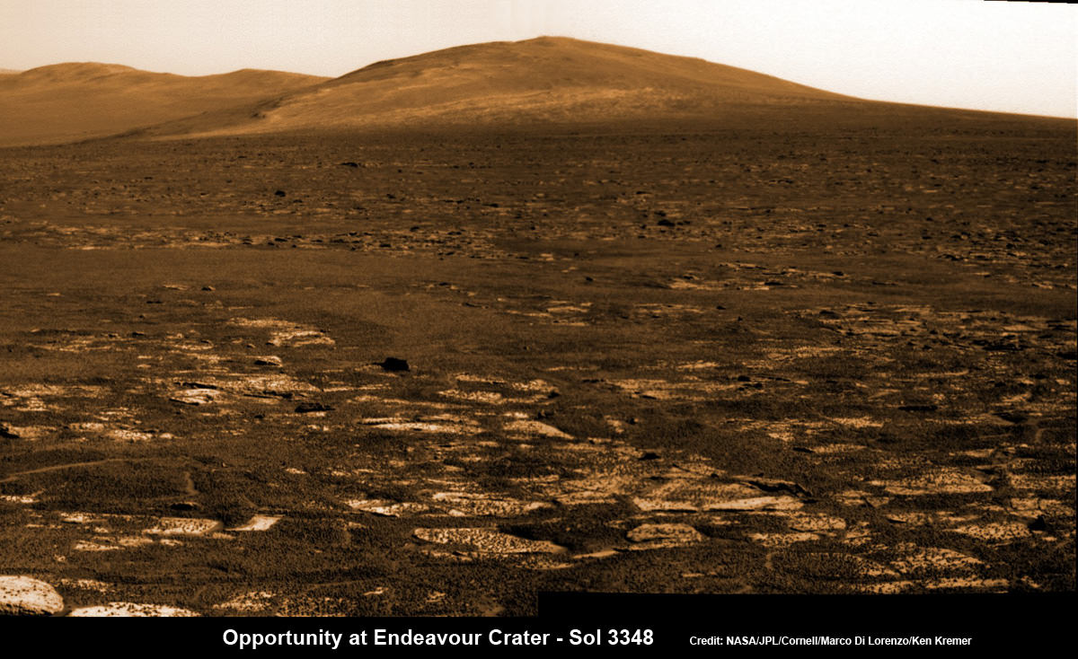
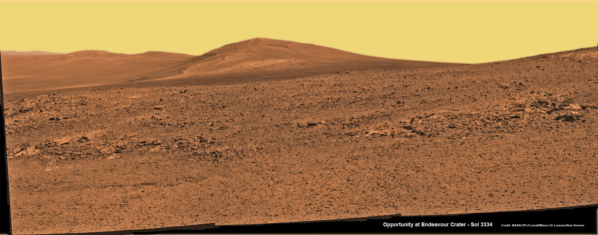
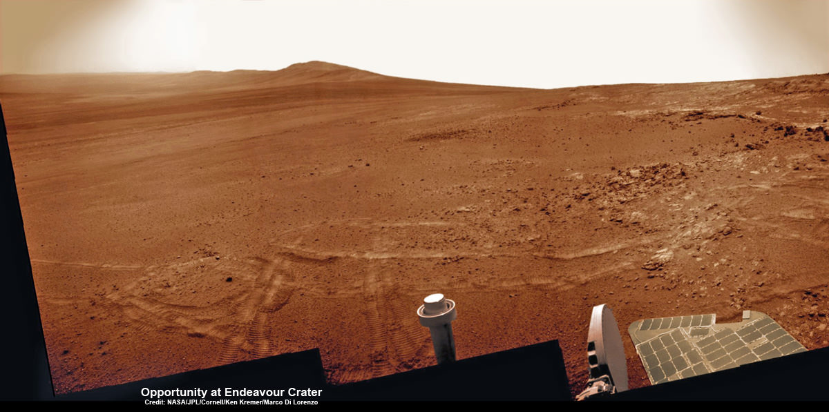
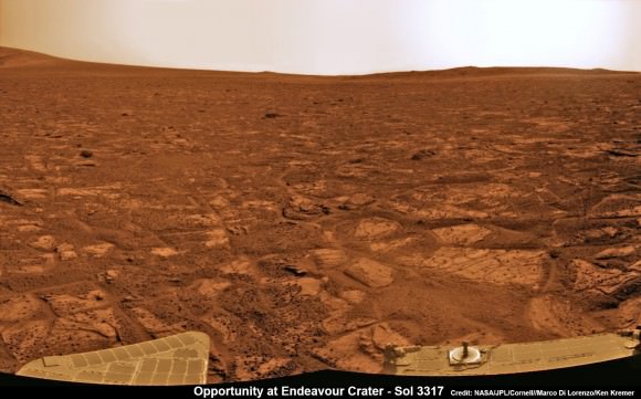
Opportunity rover’s view across Botany Bay to Solander Point - her next destination - as NASA celebrates 10 Years since blastoff for Mars on July 7, 2003. The rover will climb up Solander Point because it which may harbor clay minerals indicative of a past Martian habitable environment. This pancam mosaic was assembled from raw images taken on Sol 3348 (June 24, 2013. Credit: NASA/JPL/Cornell/ASU/Marco Di Lorenzo/Ken Kremer (kenkremer.com)
Opportunity rover’s view across Botany Bay to Solander Point – her next destination – as NASA celebrates 10 Years since blastoff for Mars on July 7, 2003. The rover will climb up Solander Point because it which may harbor clay minerals indicative of a past Martian habitable environment. This pancam mosaic was assembled from raw images taken on Sol 3348 (June 24, 2013.
Credit: NASA/JPL/Cornell/ASU/Marco Di Lorenzo/Ken Kremer (kenkremer.com)[/caption]
Today, NASA’sOpportunity rover marks a magical moment celebrating 10 years since launching to Mars on July 7, 2003 and with her impending Mountain destination filling the camera’s eye view.
The now legendary robot has vastly exceeded everyone’s expectations. Back in 2003 the science team promised us a mere 90 day ‘warranty’ following the suspenseful airbag landing on Jan. 24, 2004 at Meridiani Planum.
Today is Martian Day (or Sol) 3360. That amounts to a life expectancy and exploration ‘bonus’ of more than 37 times beyond the design lifetime.
Launch of NASA’s 2nd Mars Exploration Rover, Opportunity, aboard a Delta II Heavy rocket to Mars on July 7, 2003 at 11:18 p.m. EDT from Pad 17-B at Cape Canaveral Air Force Station, Fla. Credit: NASA
Opportunity’s twin sister Spirit blasted off three weeks earlier in June 2003 and continued functioning until 2010.
“I never thought we’d achieve nine months!” Principal Investigator Prof. Steve Squyres of Cornell University told me recently on the occasion of the rovers 9th anniversary on Mars in January 2013.
As you read this, the now decade old rover Opportunity is blazing a trail toward’s the oldest geological deposits she has ever explored – at a place called Solander Point, a raised ridge along the eroded rim of huge Endeavour Crater.
Opportunity has surpassed the halfway point in the traverse from the rim segment she has explored the past 22 months at ‘Cape York’ to her next rim segment destination at Solander.
From tip to tip, Cape York and Solander Point lie 1.2-mile (2-kilometer) apart along the western rim of Endeavour Crater. Both are raised portions of 14-mile-wide (22-kilometer-wide) Endeavour.
The rover has less than half a mile (800 meters) to go to finish the Martian dash from one rim segment to the next across an area called ‘Botany Bay’.
This view from July 2, 2013 (Sol 3355) shows the terrain that NASA’s Mars Exploration Rover Opportunity is crossing in a flat area called “Botany Bay” on the way toward “Solander Point,” which is visible on the horizon. Credit: NASA/JPL-Caltech
“We are making very good progress crossing ‘Botany Bay,’ said John Callas of NASA’s Jet Propulsion Laboratory, Pasadena, Calif., who is project manager for the mission now entering its 2nd decade.
The flat terrain of fractured, light-toned bedrock is devoid of treacherous dunes and is easy to drive across, almost like a highway, which simplifies the daily planning by the rovers Earthly handlers.
“The surface that Opportunity is driving across in Botany Bay is polygonally fractured outcrop that is remarkably good for driving,” said Brad Joliff, an Opportunity science team member and long-term planner at Washington University in St. Louis. “The plates of outcrop, like a tiled mosaic pavement, have a thin covering of soil, not enough to form the wind-blown ripples we’ve had to deal with during some other long treks. The outcrop plates are light-toned, and the cracks between them are filled with dark, basaltic soil and our old friends the ‘blueberries.”
The “blueberries” are hematite-rich, erosion-resistant concretions about the size of BB’s that Opportunity discovered when she first opened her eyes at her Eagle crater landing site. During the multi year crater hopping tour that ensued, the rover continued finding patches of blueberries all the way to Endeavour crater.
1st color panorama taken by Opportunity after landing inside Eagle Crater on Jan. 24, 2004. Credit: NASA/JPL/Cornell
Opportunity is expected to arrive at Solander’s foothills sometime in August – before the onset of the next southern hemisphere Martian winter, her 6th altogether.
Opportunity will scale Solander to continue the science quest in search of additional evidence of habitable environments with the chemical ingredients necessary to sustain Martian microbial life.
“Right now the rover team is discussing the best way to approach and drive up Solander,” Ray Arvidson told Universe Today. Arvidson is the mission’s deputy principal scientific investigator from Washington University in St. Louis, Mo.
‘Solander Point’ offers roughly about a 10 times taller stack of geological layering compared to ‘Cape York.’
Solander also offers north facing slopes where Opportunity’s solar wings can more effectively soak up the sun’s rays to generate life giving electrical power.
The robot remains in excellent health.
The total driving distance exceeds 23 miles (37 kilometers). She has snapped over 181,000 images.
Meanwhile on the opposite side of Mars at Gale Crater, Opportunity’s younger sister rover Curiosity also discovered a habitable environment originating from a time when the Red Planet was far warmer and wetter billions of years ago.
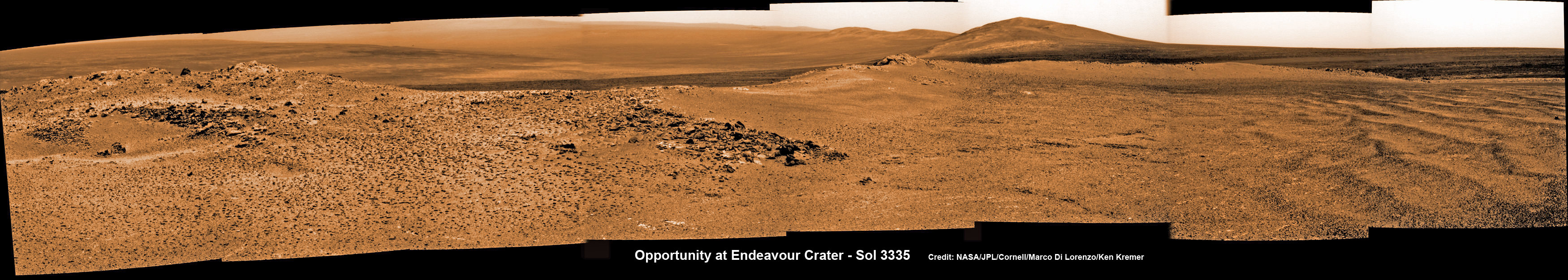
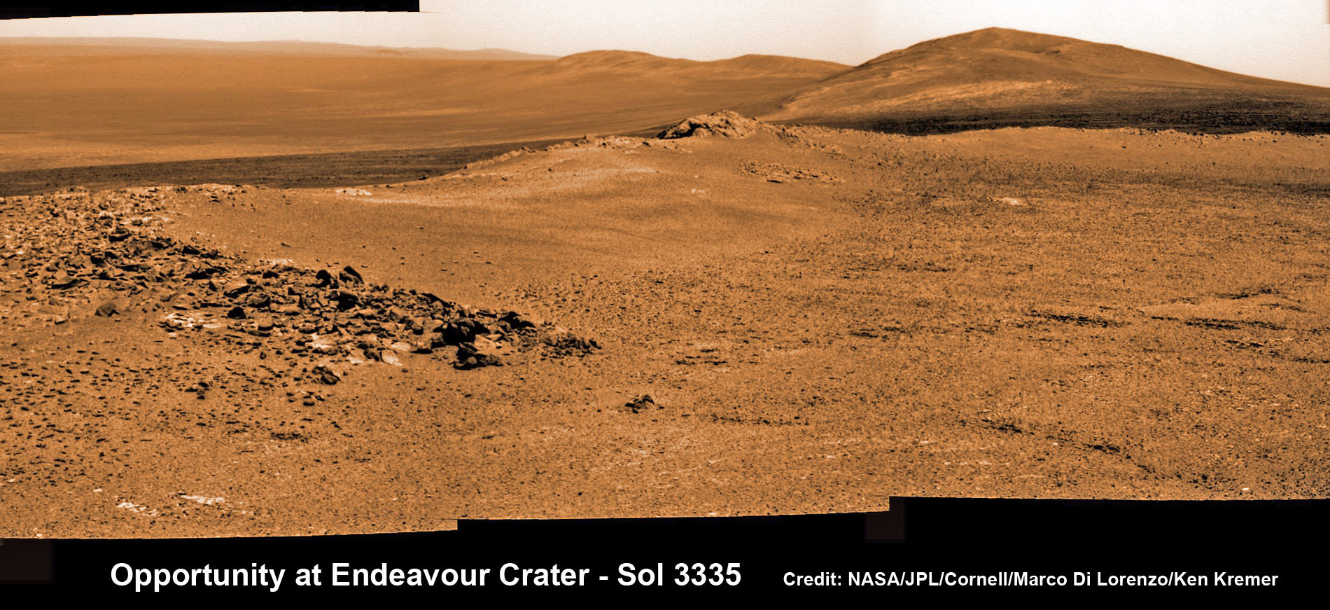
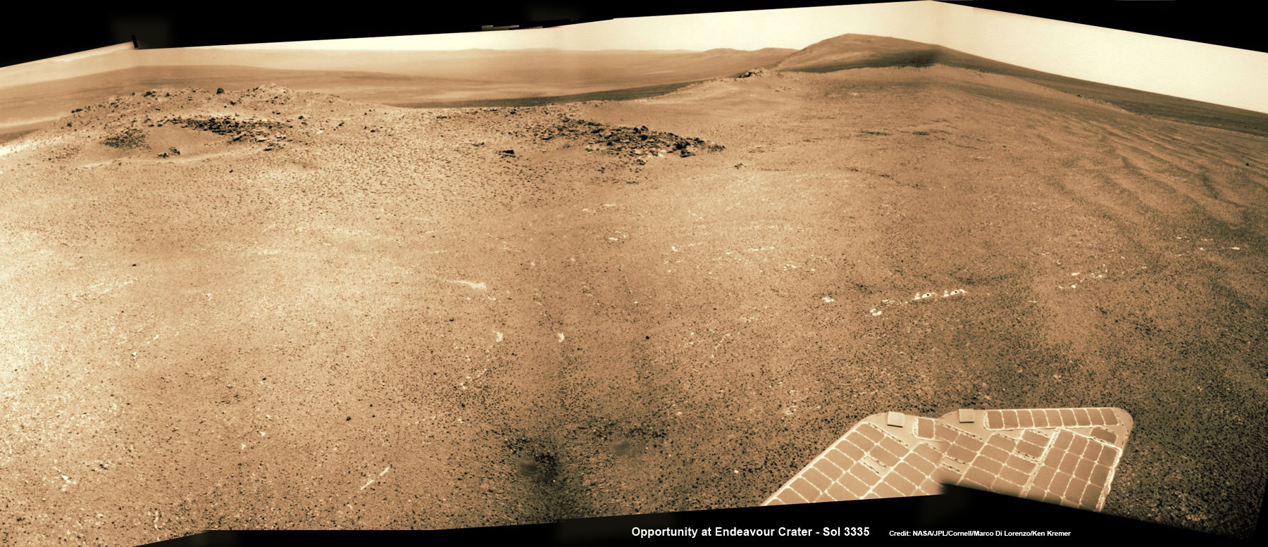
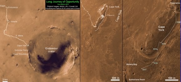
Opportunity captures spectacular panoramic view ahead to her upcoming mountain climbing goal, the raised rim of “Solander Point” at right, located along the western edge of Endeavour Crater. It may harbor clay minerals indicative of a habitable zone. The rise at left is “Nobbys Head” which the rover just passed on its southward drive to Solander Point from Cape York. This pancam photo mosaic was taken on Sol 3335, June 11, 2013 shows vast expanse of the central crater mound and distant Endeavour crater rim. Credit: NASA/JPL/Cornell/ASU/Marco Di Lorenzo/Ken Kremer (kenkremer.com) Traverse Map for NASA’s Opportunity rover from 2004 to 2013
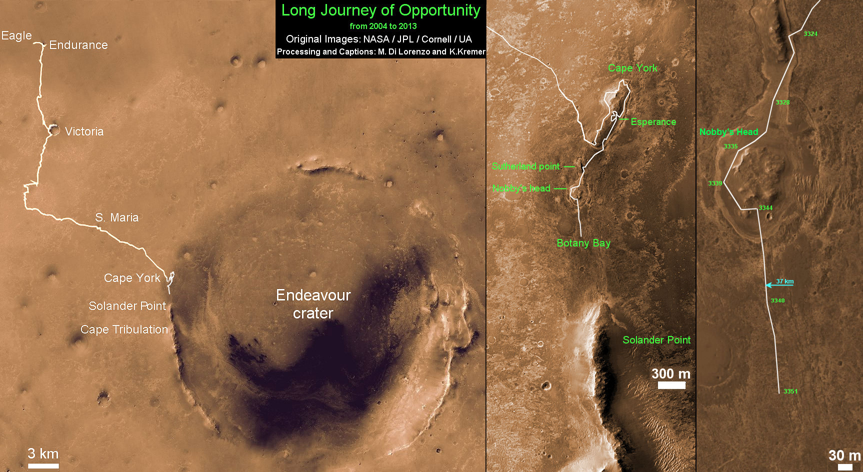
This map shows the entire path the rover has driven during more than 9 years and over 3360 Sols, or Martian days, since landing inside Eagle Crater on Jan 24, 2004 to current location heading south to Solander Point from Cape York ridge at the western rim of Endeavour Crater. Credit: NASA/JPL/Cornell/ASU/Marco Di Lorenzo/Ken Kremer
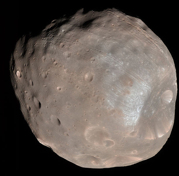
Mars moon Phobos rising in the night time Martian sky shortly after sunset in this image from a movie taken by NASA's Mars rover Curiosity on Sol 317, June 28, 2013. The apparent ring is an imaging artifact The Credit: NASA/JPL-Caltech See the complete ‘Phobos Rising’ movie below
Mars moon Phobos (above, center) rising in the night time Martian sky shortly after sunset in this still image from a movie taken by NASA’s Mars rover Curiosity on Sol 317, June 28, 2013. The apparent ring is an imaging artifact. Credit: NASA/JPL-Caltech See the complete ‘Phobos Rising’ movie below [/caption]
Every once in a while when the time is just right and no one is looking, Curiosity’s Earthly handlers allow her some night time Martian delights.
In this case a pair of rising and setting celestial events bookend another magnificent week in humankinds exploration of the Red Planet – courtesy of NASA.
This past week NASA’s Curiosity rover captured esthetically stunning imagery of Phobos rising and Our Sun setting on Mars.
Phobos is the larger of Mars pair of tiny moons. The other being Diemos.
On June 28, (Sol 317) Curiosity aimed her navigation camera straight overhead to captured a breathtaking series of 86 images as Phobos was ascending in the alien evening sky shortly after sunset.
NASA combined these raw images taken over about 27 minutes into a short movie clip, sped up from real time.
Video Caption: ‘Phobos Rising’ – This movie clip shows Phobos, the larger of the two moons of Mars, passing overhead, as observed by NASA’s Mars rover Curiosity in a series of images centered straight overhead starting shortly after sunset. Phobos first appears near the lower center of the view and moves toward the top of the view. The images were taken on June 28, 2013. The apparent ring is an imaging artifact. Credit: NASA/JPL-Caltech
The pockmarked and potato shaped moon measures about 26.8 × 22.4 × 18.4 kilometers.
Phobos orbits barely some 6,000 km (3,700 mi) above the Martian surface. One day far in the future, it will crash and burn.
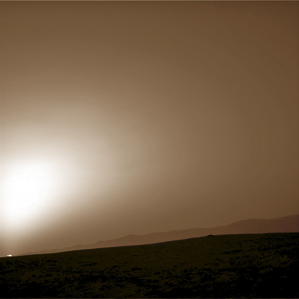
On June 22, Curiosity snapped an evocative series of Martian sunset photos as Sol set behind the eroded rim of Gale Crater – see below.
In the 2030’s, Humans may visit Phobos first before setting foot on the much more technically challenging Red Planet.
Sunset at Gale Crater
Martian sunset vista at Gale crater rim snapped by Curiosity on Sol 312, June 22, 2013. Colorized navcam image. Credit: NASA/JPL-Caltech/Ken Kremer/Marco Di LorenzoPhobos from NASA’s Mars Reconnaissance Orbiter on March 23, 2008. Credit: NASA
Opportunity rover captures spectacular view ahead to her upcoming mountain climbing goal, the raised rim of “Solander Point” at right, located along the western edge of Endeavour Crater. It may harbor clay minerals indicative of a habitable zone. This pancam photo mosaic was taken on Sol 3335, June 11, 2013. Credit: NASA/JPL/Cornell/ASU/Marco Di Lorenzo/Ken Kremer (kenkremer.com) See full panoramic scene below
Opportunity rover captures spectacular view ahead to her upcoming mountain climbing goal, the raised rim of “Solander Point” at right, located along the western edge of Endeavour Crater. It may harbor clay minerals indicative of a habitable zone. This pancam photo mosaic was taken on Sol 3335, June 11, 2013. Credit: NASA/JPL/Cornell/ASU/Marco Di Lorenzo/Ken Kremer (kenkremer.com)
See full panoramic scene – below Your last chance to “Send Your Name to Mars aboard NASA’s MAVEN orbiter” – below[/caption]
NASA’s nearly decade old Opportunity Mars rover is sailing swiftly on a southerly course towards her first true mountain climbing destination – named “Solander Point” – in search of further evidence of habitable environments with the chemical ingredients necessary to sustain Martian life forms.
At Solander Point, researchers have already spotted deep stacks of ancient rocks transformed by flowing liquid water eons ago. It is located along the western rim of huge Endeavour Crater.
“Right now the rover team is discussing the best way to approach and drive up Solander,” Ray Arvidson told Universe Today. Arvidson is the mission’s deputy principal scientific investigator from Washington University in St. Louis, Mo.
Solander Point may harbor clay minerals in the rock stacks indicative of a past Martian habitable zone.
“One idea is to drive part way up Solander from the west side of the rim, turn left and then drive down the steeper north facing slopes with the stratographic sections,” Arvidson told me.
“That way we don’t have to drive up the relatively steeper slopes. The rover can drive up rocky surfaces inclined about 12 to 15 degrees.”
“We want to go through the stratographic sections on the north facing sections.”
Solander Point mosaic captured by high resolution pancam camera on Sol 3334, June 10, 2013. Opportunity will scale Solander after arriving in August 2013 in search of chemical ingredients to sustain Martian microbes Credit: NASA/JPL/Cornell/ASU/Marco Di Lorenzo/Ken Kremer (kenkremer.com)
The science team hopes that by scaling Solander, Opportunity will build on her recent historic discovery of a habitable environment at a rock called “Esperance” that possesses a cache of phyllosilicate clay minerals.
These aluminum rich clay minerals typically form in neutral, drinkable water that is not extremely acidic or basic and therefore could support a path to potential Martian microbes.
“Esperance ranks as one of my personal Top 5 discoveries of the mission,” said Steve Squyres of Cornell University, Ithaca, N.Y., principal investigator for NASA’s rover mission at a recent media briefing.
‘Esperance’ Target Examined by Opportunity in May 2013. The pale rock called “Esperance,” has a high concentration of clay minerals formed in near neutral water indcating a spot favorable for life. Credit: NASA/JPL-Caltech/Cornell Univ./Arizona State Univ.
Using high resolution CRISM spectral data collected from Mars orbit, the rover was specifically directed to Esperance, Arvidson explained. The rock was found about a kilometer back on Matijevic Hill at ‘Cape York’, a rather low hilly segment of the western rim of giant Endeavour crater which spans 14 miles (22 km) across.
‘Solander Point’ offers roughly about a 10 times taller stack of geological layering compared to ‘Cape York.’ Both areas are raised segments of the western rim of Endeavour Crater.
The team is working now to obtain the same type of high resolution spectral evidence for phyllosilicate clay minerals at Solander as they had at Cape York to aid in targeting Opportunity to the most promising outcrops, Arvidson explained.
Opportunity is snapping ever more spectacular imagery of Solander Point and the eroded rim of Endeavour Crater as she approaches closer every passing Sol, or Martian Day. See our original photo mosaics herein by Marco Di Lorenzo and Ken Kremer.
Opportunity captures spectacular panoramic view ahead to her upcoming mountain climbing goal, the raised rim of “Solander Point” at right, located along the western edge of Endeavour Crater. It may harbor clay minerals indicative of a habitable zone. The rise at left is “Nobbys Head” which the rover just passed on its southward drive to Solander Point from Cape York. This pancam photo mosaic was taken on Sol 3335, June 11, 2013 shows vast expanse of the central crater mound and distant Endeavour crater rim.
Credit: NASA/JPL/Cornell/ASU/Marco Di Lorenzo/Ken Kremer (kenkremer.com)
The long lived robot arrived at the edge of Endeavour crater in mid-2011 and will spend her remaining life driving around the scientifically rich crater rim segments.
On June 21, 2013, Opportunity marked five Martian years on Mars since landing on Jan 24, 2004 with a mere 90 day (Sol) ‘warranty’.
This week Opportunity’s total driving distance exceeded 23 miles (37 kilometers).
The solar powered robot remains in excellent health and the life giving solar arrays are producing plenty of electrical power at the moment.
Solander Point also offers northerly tilled slopes that will maximize the power generation during Opportunity’s upcoming 6th Martian winter .
The rover handlers want Opportunity to reach Solander’s slopes by August, before winter’s onset.
As ot today (tosol) Opportunity has trekked about halfway from Cape York to Solander Point – tip to tip.
On the opposite side of Mars at Gale Crater, Opportunity’s younger sister rover Curiosity also discovered clay minerals and a habitable environment originating from a time when the Red Planet was far warmer and wetter billions of years ago.
And this is your last chance to “Send Your Name to Mars” aboard NASA’s MAVEN orbiter- details here. Deadline: July 1, 2013. Launch: Nov. 18, 2013
Wide angle view of Endeavour Crater showing Solander Point and Cape Tribulation in this photo mosaic captured by navcam camera on Sol 3335, June 11, 2013. Opportunity will scale Solander after arriving in August 2013 in search of chemical ingredients to sustain Martian microbes. Credit: NASA/JPL/Cornell/Marco Di Lorenzo/Ken Kremer (kenkremer.com)Traverse Map for NASA’s Opportunity rover from 2004 to 2013. This map shows the entire path the rover has driven during more than 9 years and over 3351 Sols, or Martian days, since landing inside Eagle Crater on Jan 24, 2004 to current location heading south to Solander Point from Cape York ridge at the western rim of Endeavour Crater. Credit: NASA/JPL/Cornell/ASU/Marco Di Lorenzo/Ken Kremer
This is a cropped, reduced version of panorama from NASA's Mars rover Curiosity with 1.3 billion pixels in the full-resolution version see full panorama below. It shows Curiosity at the "Rocknest" site where the rover scooped up samples of windblown dust and sand. Curiosity used three cameras to take the component images on several different days between Oct. 5 and Nov. 16, 2012. Viewers can explore this image with pan and zoom controls at http://mars.nasa.gov/bp1/. Credit: NASA/JPL-Caltech/MSSS
This is a cropped, reduced version of panorama from NASA’s Mars rover Curiosity with 1.3 billion pixels in the full-resolution version. See full panorama below. It shows Curiosity at the “Rocknest” site where the rover scooped up samples of windblown dust and sand. Curiosity used three cameras to take the component images on several different days between Oct. 5 and Nov. 16, 2012. Viewers can explore this image with pan and zoom controls at http://mars.nasa.gov/bp1/. Credit: NASA/JPL-Caltech/MSSS Updated with link to interactive Gigapan version
[/caption]
NASA’s newly produced and absolutely spectacular panorama from the Curiosity mega rover offers armchair explorers back on Earth a mammoth 1.3 billion pixels worth of Mars in all its colorful glory.
And everyone can move back and forth around the interactive panorama and zoom in – with special embedded tools- to your hearts delight in exquisite detail at the ‘Rocknest’ site where the rover spent her first extended science stay in late 2012.
This extra special Rocknest panorama is the first NASA- produced view comprising more than a billion pixels from the surface of the Red Planet.
It offers a full 360 degree panoramic view around the rover encompassing breathtaking vistas of Mount Sharp and the eerie rim of Gale Crater, some 20 miles distant.
Mount Sharp rises 3.4 miles (5.5 km) high and is the target destination. The team hopes Curiosity will arrive at the base of Mount Sharp perhaps late this year or early in 2014.
The ‘Rocknest’ scene was assembled from nearly 900 raw images snapped by three different cameras among the 17 total that Curiosity uses as she trundles across the crater floor in search of the ingredients of life.
Billion-Pixel View From Curiosity at Rocknest, Raw Color. This full-circle, reduced view combined nearly 900 images taken by NASA’s Curiosity Mars rover, generating a panorama with 1.3 billion pixels in the full-resolution version. The view is centered toward the south, with north at both ends. It shows Curiosity at the “Rocknest” site where the rover scooped up samples of windblown dust and sand. Curiosity used three cameras to take the component images on several different days between Oct. 5 and Nov. 16, 2012. Credit: NASA/JPL-Caltech/MSSS
The panorama was created by Bob Deen of the Multi-Mission Image Processing Laboratory at NASA’s Jet Propulsion Laboratory, Pasadena, Calif, where the mission is managed on a daily basis.
“It gives a sense of place and really shows off the cameras’ capabilities,” said Deen in a statement. “You can see the context and also zoom in to see very fine details.”
Check here for the full, billion pixel interactive cylindrical and panoramic viewers
“Rocknest” was a windblown ripple of sand dunes that Curiosity drove to after departing from the touchdown site at ‘Bradbury Landing’ and thoroughly investigated in October and November 2012.
It was at ‘Rocknest’ where the six wheeled rover famously deployed her robotic arm to scoop into the Martian dirt for the very first time and then delivered those first grains to the duo of analytical chemistry labs inside her belly that lie at the heart of Curiosity’s science mission.
Deen assembled the color product using 850 raw images from the 100 mm telephoto camera of Curiosity’s Mast Camera instrument, supplemented with 21 more from the Mastcam’s wider-angle 34 mm camera.
In order to take in the rover itself, the view also included 25 black-and-white raw images from the Navigation Camera on the Mast.
All the images were taken between Oct. 5 and Nov. 16, 2012 while the rover was stationary at Rocknest.
And check this link to a new NASA JPL Curiosity gallery on the GigaPan website – here
Because the images were captured over many days and at different times of day, the lighting and atmospheric clarity varies – especially in distant views to the crater rim.
Since landing on August 6, 2012, Curiosity has already accomplished her primary goal of finding a habitable zone at Gale Crater with an environment that could once of supported Martian microbial life – at the current worksite at ‘Yellowknife Bay.’
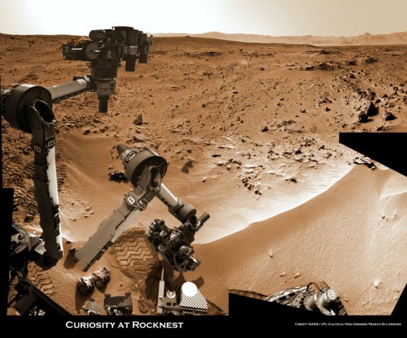
Time lapse context view of Curiosity maneuvering her robotic arm to conduct close- up examination of windblown ‘Rocknest’ ripple site. Curiosity inspects “bootlike” wheel scuff mark with the APXS (Alpha Particle X-Ray Spectrometer) and MAHLI (Mars Hand Lens Imager) instruments positioned on the rotatable turret at the arm’s terminus. Mosaic stitched from Navcam images on Sols 57 & 58 shows the arm in action just prior to 1st sample scooping here. Eroded rim of Gale Crater rim is visible on the horizon. Credit: NASA/JPL-Caltech/Ken Kremer (kenkremer.com)/Marco Di Lorenzo
The 1 ton robot is equipped with 10 state-of-the-art science instruments with research capabilities that far surpass any prior landed mission and is in the middle of the 2-year primary mission to the Red Planet.
Meanwhile, Curiosity’s older sister rover Opportunity has also discovered clay minerals and a habitable zone on the opposite side of the Red Planet – details here.
And don’t forget to “Send Your Name to Mars” aboard NASA’s MAVEN orbiter- details here. Deadline: July 1, 2013
…………….
Learn more about Mars, Curiosity, Opportunity, MAVEN, LADEE and NASA missions at Ken’s upcoming lecture presentations
June 23: “Send your Name to Mars on MAVEN” and “CIBER Astro Sat, LADEE Lunar & Antares Rocket Launches from Virginia”; Rodeway Inn, Chincoteague, VA, 8 PM
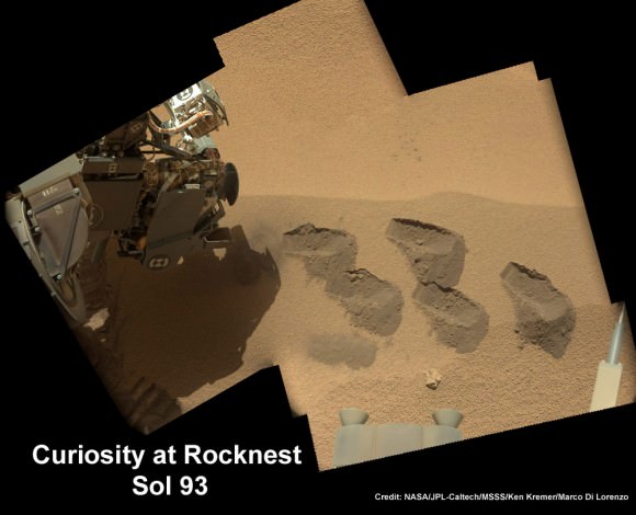
Curiosity scooped 5 times into Martian soil at Rocknest windblown ripple and delivered samples to the SAM chemistry instrument for analysis. This color mosaic was stitched together from hi-res color images taken by the robots 34 mm Mastcam camera on Sols 93 and 74. Credit: NASA / JPL-Caltech /MSSS/Ken Kremer (kenkremer.com)/Marco Di Lorenzo
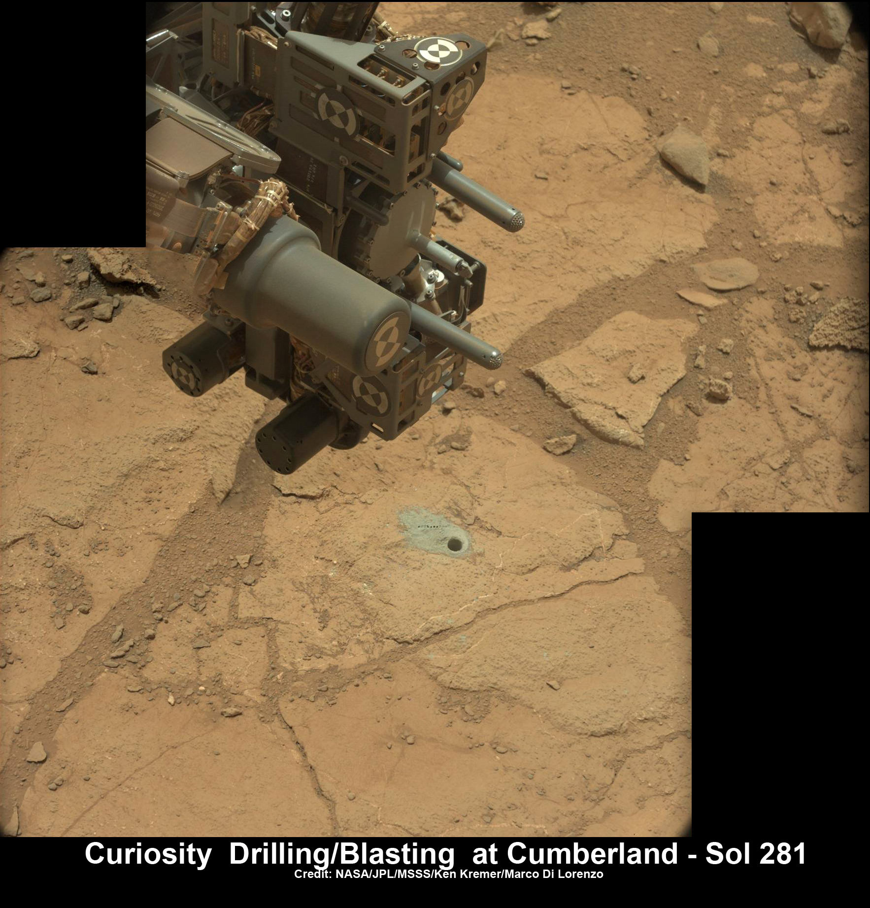
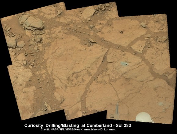
Curiosity’s hi tech ‘hand’ and percussion drill hovers above 2nd bore hole at Cumberland mudstone rock after penetrating laser blasting to unlock secrets of ancient flow of Martian water. Photo mosaic assembled from high resolution Mastcam images on May 21, 2013, Sol 281. Credit: NASA/JPL-Caltech/MSSS/Ken Kremer (kenkremer.com)/Marco Di Lorenzo
Ten months after her breathtaking touchdown on the Red Planet, NASA’s Curiosity rover is nearly set to embark on an epic drive like no other in space history to the slopes of mysterious Mount Sharp – looming supreme inside Gale Crater and the primary mission objective.
But not before the robot completes a few last critical science tasks to more fully illuminate the potential for the origin of Martian microbes in the habitable zone discovered at the work-site of her first penetrations into Mars water altered surface.
The rover science team has chosen a trio of final targets to investigate around the shallow basin of Yellowknife Bay, that resembles a dried out lakebed, where Curiosity has toiled for the past six months, drilled twice into the mudstone outcrops at ‘John Klein’ and ‘Cumberland’ and repeatedly fired her powerful science laser.
Curiosity will revisit a pair of intriguing outcrops named ‘Point Lake’ and ‘Shaler’ that the rover briefly investigated before arriving at ‘John Klein’, said Joy Crisp of JPL, Curiosity’s deputy project scientist, at a media briefing.
“Shaler might be a river deposit. Point Lake might be volcanic or sedimentary. A closer look at them could give us better understanding of how the rocks we sampled with the drill fit into the history of how the environment changed.”
Curiosity will employ nearly all her science instruments to study the outcrops – except the drill.
“It’s highly unlikely to drill at ‘Point Lake’ and ‘Shaler’ because we want to get driving,” Crisp told Universe Today.
“We might drill somewhere along the way to Mount Sharp depending on whether we find something compelling.”
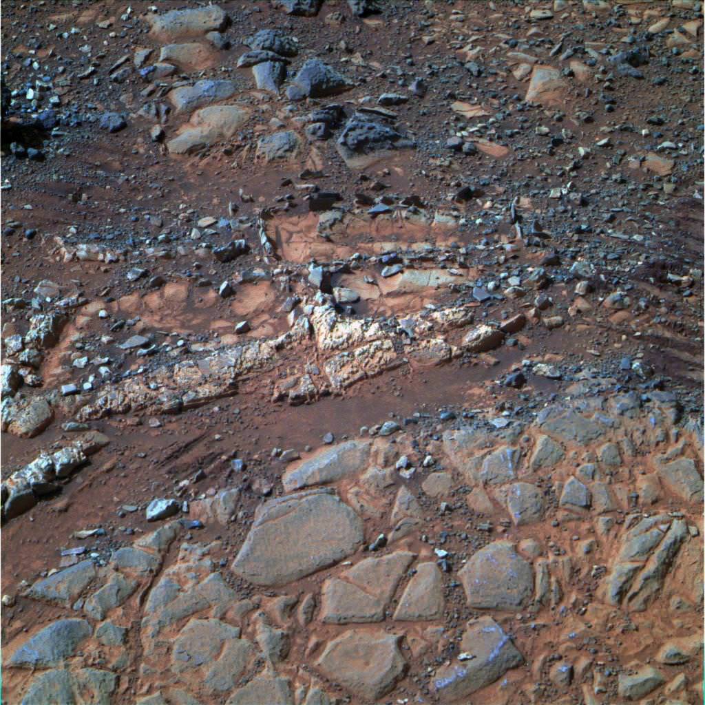
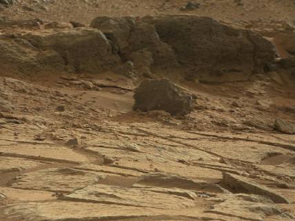
‘Point Lake’ Outcrop in Gale Crater. A priority target for a closer look byCuriosity before the rover departs the “Glenelg” area east of its landing site. The pitted outcrop called “Point Lake” is about 7 feet (2 meters) wide and 20 inches (50 centimeters) high. A closer inspection may yield information about whether it is a volcanic or sedimentary deposit. Credit: NASA/JPL-Caltech/MSSS
Researchers will also use the DAN (Dynamic Albedo of Neutrons) instrument to look for traces of mineral bound water – in the form of hydrogen – at the boundary between bedrock areas of mudstone and sandstone.
Thereafter, Curiosity’s handlers will command the 1 ton behemoth to begin the drive to the lower reaches of Mount Sharp which lies about 6 miles (10 kilometers) distant – as the Martian crow flies.
Mount Sharp rises about 3.4 miles (5.5 km) from the center of Gale Crater. It’s taller than Mount Ranier in Washington State.
Billions of years of Mars geologic history are preserved in the sedimentary layers of Mount Sharp – along with potential signatures of the chemical ingredients of life.
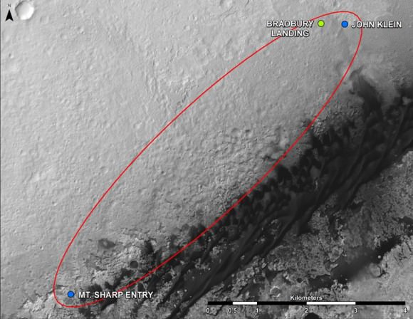
Curiosity Route Map From ‘Glenelg’ to Mount Sharp.
This map shows where NASA’s Mars rover Curiosity landed in August 2012 at “Bradbury Landing”; the area where the rover worked from November 2012 through May 2013 at and near the “John Klein” target rock in the “Glenelg” area; and the mission’s next major destination, the entry point to the base of Mount Sharp. Credit: NASA/JPL-Caltech/Univ. of Arizona
“The drive will start in a few weeks,” said Curiosity Project Manager Jim Erickson of NASA’s Jet Propulsion Laboratory, Pasadena, Calif. at the briefing.
But the team will be on the lookout for targets of opportunity along the way.
“We are on a mission of exploration. If we come across scientifically interesting areas, we are going to stop and examine them before continuing the journey,” Erikson added.
“If we pass something amazing and compelling we might turn around and drive back,” Crisp added.
It could take nearly a year to arrive at Mount Sharp. And Curiosity must pass through a potentially treacherous dune field to get there – see NASA JPL route map above.
“We are looking for the best path though,” said Erickson.
NASA chose Gale as the landing site specifically to dispatch Curiosity to investigate the sedimentary layers of Mount Sharp because it exhibited signatures of clay minerals that form in neutral water and that could possibly support the origin and evolution of simple Martian life forms, past or present.
“We have a real desire to get to Mount Sharp because there we see variations in the mineralogy as we go up from the base to higher levels and a change in the record of the environment,” said Crisp.
Analysis of the initial gray colored, powdery ‘John Klein’ sample by Curiosity’s pair of onboard chemistry labs – SAM & Chemin – revealed that this location on Mars was habitable in the past and possesses the key chemical ingredients – such as clay minerals – required to support microbial life forms- thereby successfully accomplishing the key science objective of the mission and making a historic discovery long before even arriving at destination Mount Sharp.
Besides the science measurements, researchers also learned lot about how to operate the complex drilling and sample delivery mechanisms much more efficiently for the second drilled rock sample.
The sieved and pulverized Cumberland sample was delivered in about a quarter of the time compared to the John Klein sample – accomplished at a deliberately measured and cautious pace.
Context view of Curiosity’s 2nd drill site at Cumberland rock on the floor of Yellowknife Bay basin showing ancient water altered rocks where the rover found environmental conditions favorable for microbial life. Mastcam images on May 23, 2013, Sol 283. Credit: NASA/JPL-Caltech/MSSS/Ken Kremer (kenkremer.com)/Marco Di Lorenzo
Analysis of the “Cumberland” powder is currently in progress. The goal is to determine how it compares chemically and to confirm the results found at ‘John Klein.’
“No results from Cumberland are available yet,” said Crisp.
The robot used the powerful million watt ChemCam laser to blast into the Cumberland drill hole and gray tailings scattered on the surface to glean as much insight and measurements of the chemical composition and transformation by water as possible before departing.
Curiosity has just arrived at “Point Lake’. Stay tuned for my next Curiosity story.
Meanwhile, Curiosity’s older sister rover Opportunity has likewise discovered clay minerals and a habitable zone on the opposite side of the Red Planet – details here.
And don’t forget to “Send Your Name to Mars” aboard NASA’s MAVEN orbiter- details here. Deadline: July 1, 2013
Learn more about Mars, Curiosity, Opportunity, MAVEN, LADEE and NASA missions at Ken’s upcoming lecture presentations
June 23: “Send your Name to Mars on MAVEN” and “CIBER Astro Sat, LADEE Lunar & Antares Rocket Launches from Virginia”; Rodeway Inn, Chincoteague, VA, 8 PM
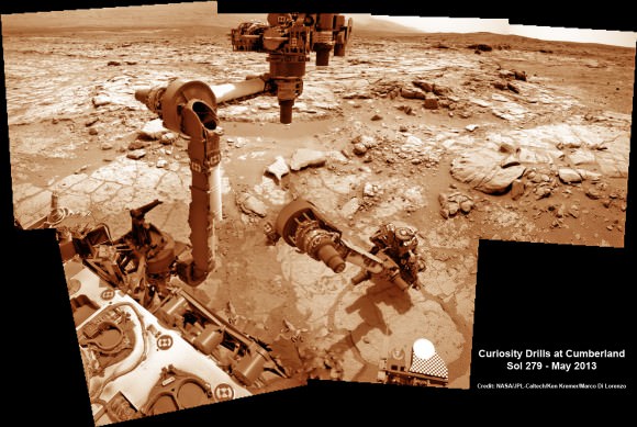
This time lapse mosaic shows Curiosity moving her robotic arm to drill into her 2nd rockt target named “Cumberland” to collect powdery material on May 19, 2013 (Sol 279) for analysis by her onboard chemistry labs; SAM & Chemin. The photomosaic was stitched from raw images captured by the navcam cameras on May 14 & May 19 (Sols 274 & 279). Credit: NASA/JPL-Caltech/Ken Kremer/Marco Di Lorenzo
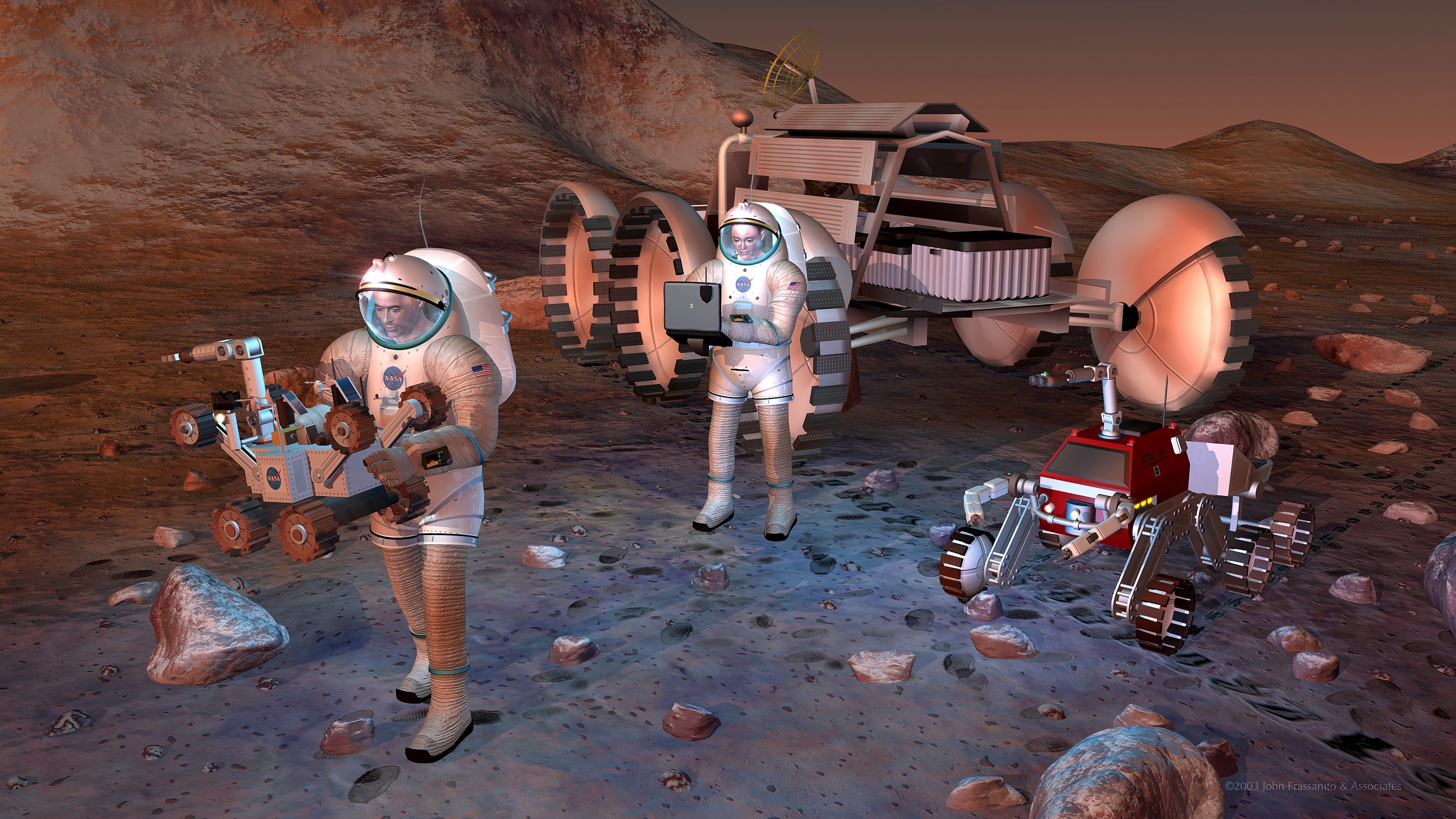
NASA astronauts exploring Mars on future missions starting perhaps in the 2030’s will require protection from long term exposure to the cancer causing space radiation environment. Credit: NASA.
New measurements of the energetic space radiation environment present in interplanetary space taken by NASA’s Curiosity rover confirm what has long been suspected – that lengthy years long voyages by astronauts to deep space destinations like Mars will expose the crews to high levels of radiation that – left unchecked – would be harmful to their health and increase their chances of developing fatal cancers.
Although the data confirm what scientists had suspected, it’s equally important to state that the space radiation data are not ‘show stoppers” for human deep space voyages to the Red Planet and other destinations because there are a multitude of counter measures- like increased shielding and more powerful propulsion – that NASA and the world’s space agencies can and must implement to reduce and mitigate the dangerous health effects of radiation on human travelers.
The new radiation data was released at a NASA media briefing on May 30 and published in the journal Science on May 31.
Indeed the new measurements collected by Curiosity’s Radiation Assessment Detector (RAD) instrument during her 253-day, 560-million- kilometer journey enroute to the Red Planet in 2011 and 2012 will provide important insights to allow NASA to start designing systems for safely conducting future human missions to Mars.
“NASA wants to send astronauts to Mars in the 2030’s,” Chris Moore, NASA’s deputy director of Advanced Exploration Systems NASA HQ, said to reporters at the media briefing.
“The Human Spaceflight and Planetary Science Divisions at NASA are working together to get the data needed for human astronauts. RAD is perfect to collect the data for that,” said Moore.
The RAD data indicate that astronauts would be exposed to radiation levels that would exceed the career limit levels set by NASA during a more than year long voyage to Mars and back using current propulsion systems, said Eddie Semones, spaceflight radiation health officer at the Johnson Space Center.
This graph compares the radiation dose equivalent for several types of experiences, including a calculation for a trip from Earth to Mars based on measurements made by the Radiation Assessment Detector (RAD) instrument shielded inside NASA’s Mars Science Laboratory spacecraft during the flight from Earth to Mars in 2011 and 2012. The data show that during a typical 6 month cruise to Mars the astronaut crews would be exposed to more than 3 times the typical 6 month exposure of astronauts aboard the ISS. The scale is logarithmic; each labeled value is 10 times greater than the next lowest one. The “dose equivalent” units are millisieverts. Credit: NASA/JPL-Caltech/SwRI
NASA’s Humans to Mars planning follows initiatives outlined by President Obama.
“As this nation strives to reach an asteroid and Mars in our lifetimes, we’re working to solve every puzzle nature poses to keep astronauts safe so they can explore the unknown and return home,” said William Gerstenmaier, NASA’s associate administrator for human exploration and operations in Washington, in a statement.
The International Space Station already in low Earth orbit and the Orion crew capsule under development will serve as very useful platforms to conduct real life experiments on resolving the health risks posed by long term exposure to space radiation.
“We learn more about the human body’s ability to adapt to space every day aboard the International Space Station, said Gerstenmaier. “As we build the Orion spacecraft and Space Launch System rocket to carry and shelter us in deep space, we’ll continue to make the advances we need in life sciences to reduce risks for our explorers. Curiosity’s RAD instrument is giving us critical data we need so that we humans, like the rover, can dare mighty things to reach the Red Planet.”
RAD was the first instrument to collect radiation measurements during the cruise phase to the Red Planet. It is mounted on the top deck of the Curiosity rover.
“Although RAD’s objective is to characterize the radiation environment on the surface of Mars, it’s also good for the cruise phase,” Don Hassler, RAD Principal Investigator at the Southwest Research Institute (SWRI) told reporters.
“Since Orion and MSL are similar sized RAD is ideal for collecting the data.”
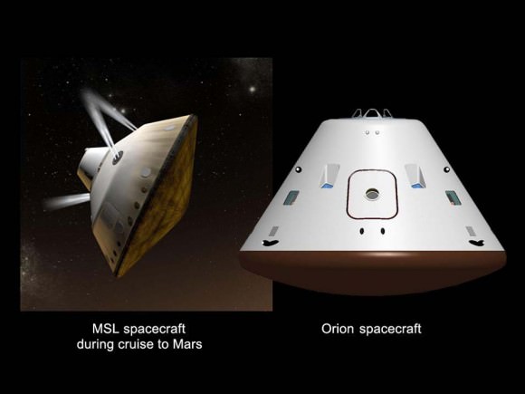
Mars Cruise Vehicles. This graphic shows a comparison of NASA’s Mars Science Laboratory (MSL) cruise capsule and NASA’s Orion spacecraft, which is being built now at NASA’s Johnson Space Center and will one day send astronauts to Mars. The rover Curiosity is tucked inside of the Mars Science Laboratory cruise vehicle like human beings would be tucked inside Orion. MSL are Orion are similar in size. Credit: NASA/JPL-Caltech/JSC
Hassler explained that RAD measures two types of radiation that pose health risks to astronauts. First, the steady stream of low dose galactic cosmic rays (GCRs), and second the short-term and unpredictable exposures to solar energetic particles (SEPs) arising from solar flares and coronal mass ejections (CME’s).
Radiation exposure is known to increase a person’s risk of suffering fatal cancer.
Exposure is measured in units of Sievert (Sv) or milliSievert (one one-thousandth Sv). Being exposed to a dose of 1 Sievert (Sv) over time results in a five percent increased risk of developing cancer.
NASA’s current regulations limit the potential for increased cancer risk to 3 percent for astronauts currently working on the ISS in low-Earth orbit.
RAD determined that the Curiosity rover was exposed to an average of 1.8 milliSieverts per day during the 8.5 month cruise to Mars, due mostly to Galactic Cosmic Rays, said Cary Zeitlin, SWRI Principal Scientist for MSL,at the briefing. “Solar particles only accounted for about 3 to 5 percent of that.”
During a typical 6 month cruise to Mars the astronaut crews would be exposed to 330 millisieverts. That is more than 3 times the typical 6 month exposure of astronauts aboard the ISS which amounts to about 100 millisieverts. See graphic above.
“The 360 day interplanetary round trip exposure would be 660 millisieverts based on chemical propulsion methods,” Zeitlin told Universe Today. “A 500 day mission would increase that to 900 millisieverts.”
By comparison, the average annual exposure for a typical person in the US from all radiation sources is less than 10 millisieverts.
The Earth’s magnetic field provides partial radiation shielding for the ISS astronauts living in low-Earth orbit.
“In terms of accumulated dose, it’s like getting a whole-body CT scan once every five or six days,” says Zeitlin.
And that round trip dose of 660 millisieverts doesn’t even include the astronauts surface stay on Mars – which would significantly raise the total exposure count. But luckily for the crew the surface radiation is less.
“The radiation environment on the surface of Mars is about half that in deep space since its modified by the atmosphere,” Hassler told Universe Today. “We will publish the surface data in a few months.”
NASA will need to decide whether to reassess the acceptable career limits for astronauts exposure to radiation from galactic cosmic rays and solar particle events during long duration deep space journeys.
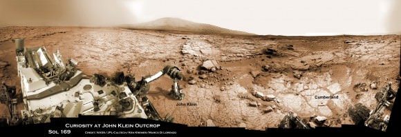
Panoramic view of Yellowknife Bay basin back dropped by Mount Sharp shows the location of the first two drill sites – John Klein & Cumberland – targeted by NASA’s Curiosity Mars rover and the RAD radiation detector which took the first deep space measurements of harmful space radiation during the cruise phase to Mars in 2011 and 2012 . Curiosity accomplished historic 1st drilling into Martian rock at John Klein outcrop on Feb 8, 2013 (Sol 182) near where the robotic arm is touching the surface. This week the rover scooted about 9 feet to the right to Cumberland (right of center) for 2nd drill campaign on May 19, 2013 (Sol 279). Credit: NASA/JPL-Caltech/Ken Kremer – kenkremer.com/Marco Di Lorenzo
And don’t forget to “Send Your Name to Mars” aboard NASA’s MAVEN orbiter- details here. Deadline: July 1, 2013
…………….
Learn more about Conjunctions, Mars, Curiosity, Opportunity, MAVEN, LADEE and NASA missions at Ken’s upcoming lecture presentations
June 4: “Send your Name to Mars on MAVEN” and “CIBER Astro Sat, LADEE Lunar & Antares Rocket Launches from Virginia”; Rodeway Inn, Chincoteague, VA, 8:30 PM
Sources of Ionizing Radiation in Interplanetary Space. The Radiation Assessment Detector (RAD) on NASA’s Curiosity Mars rover monitors high-energy atomic and subatomic particles coming from the sun, distant supernovae and other sources. The two types of radiation are known as Galactic Cosmic Rays and Solar Energetic Particles. RAD measured the flux of this energetic-particle radiation while shielded inside the Mars Science Laboratory spacecraft on the flight delivering Curiosity from Earth to Mars, and continues to monitor the flux on the surface of Mars. Credit: NASA/JPL-Caltech/SwRI
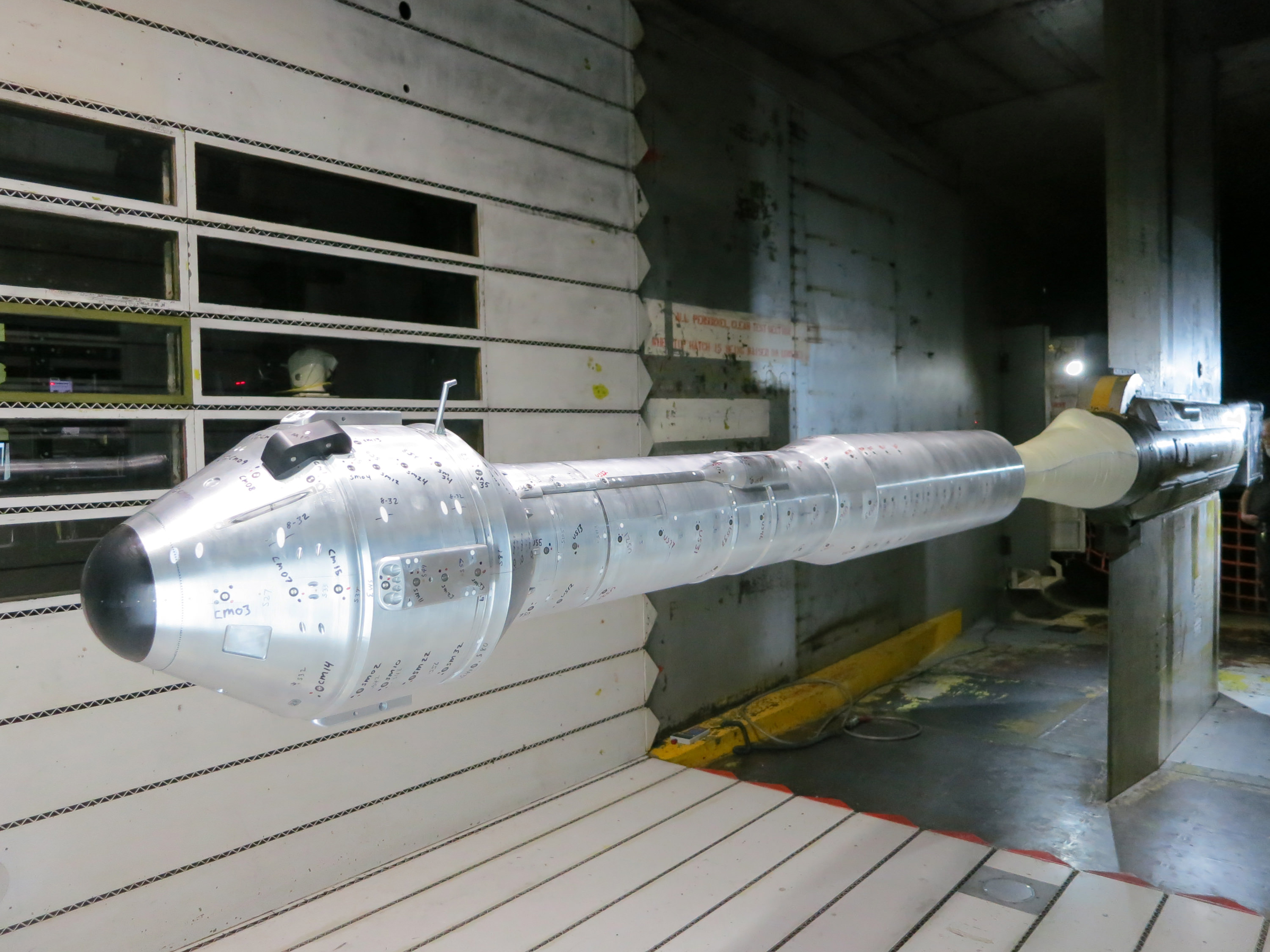
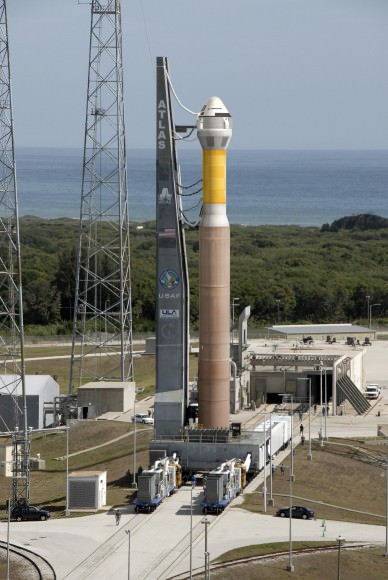
Shown is the integrated CST-100 crew capsule and Atlas V launcher model at NASA's Ames Research Center. The model is a 7 percent model of the Boeing CST-100 spacecraft, launch vehicle adaptor and launch vehicle. Credit: Boeing
The next time that American astronauts launch to space from American soil it will surely be aboard one of the new commercially built “space taxis” currently under development by a trio of American aerospace firms – Boeing, SpaceX and Sierra Nevada Corp – enabled by seed money from NASA’s Commercial Crew Program (CCP).
Boeing has moved considerably closer towards regaining America’s lost capability to launch humans to space when the firm’s privately built CST-100 crew capsule achieved two key new milestones on the path to blastoff from Florida’s Space Coast.
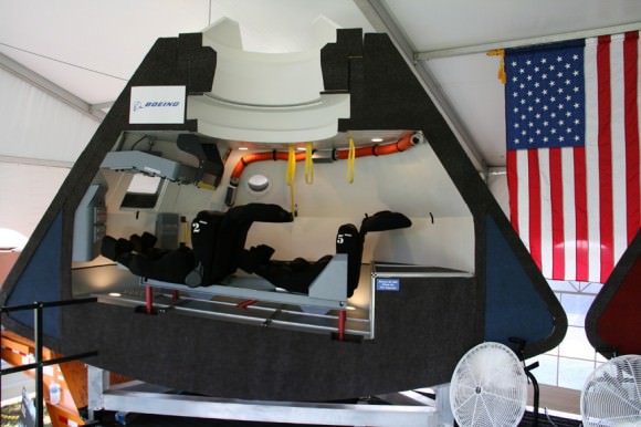
The CST-100 capsule is designed to carry a crew of up to 7 astronauts on missions to low-Earth orbit (LEO) and the International Space Station (ISS) around the middle of this decade.
Boeing CST-100 crew vehicle docks at the ISS. Credit: Boeing
Boeing’s crew transporter will fly to space atop the venerable Atlas V rocket built by United Launch Alliance (ULA) from Launch Complex 41 on Cape Canaveral Air Force Station in Florida.
The Boeing and ULA teams recently completed the first wind tunnel tests of a 7 percent scale model of the integrated capsule and Atlas V rocket (photo above) as well as thrust tests of the modified Centaur upper stage.
The work is being done under the auspices of NASA’s Commercial Crew Integrated Capability (CCiCap) initiative, intended to make commercial human spaceflight services available for both US government and commercial customers, such as the proposed Bigelow Aerospace mini space station.
Boeing CST-100 capsule mock-up, interior view. Credit: Ken Kremer – kenkremer.com
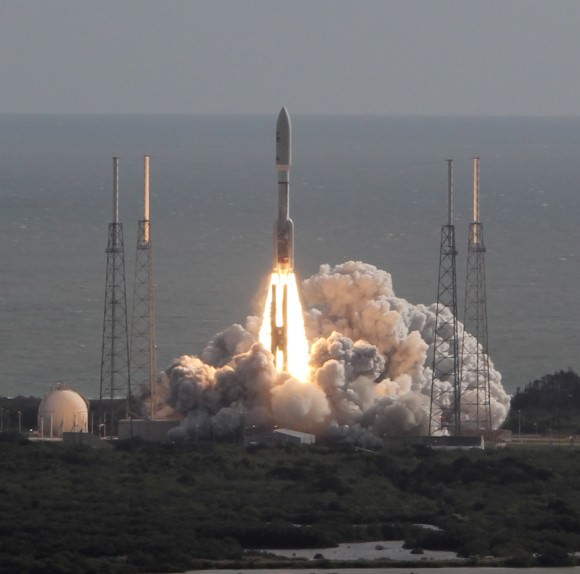
Since its maiden liftoff in 2002, the ULA Atlas V rocket has flawlessly launched numerous multi-billion dollar NASA planetary science missions like the CuriosityMars rover, Juno Jupiter orbiter and New Horizons mission to Pluto as well as a plethora of top secret Air Force spy satellites.
But the two stage Atlas V has never before been used to launch humans to space – therefore necessitating rigorous testing and upgrades to qualify the entire vehicle and both stages to meet stringent human rating requirements.
“The Centaur has a long and storied past of launching the agency’s most successful spacecraft to other worlds,” said Ed Mango, NASA’s CCP manager at the agency’s Kennedy Space Center in Florida. “Because it has never been used for human spaceflight before, these tests are critical to ensuring a smooth and safe performance for the crew members who will be riding atop the human-rated Atlas V.”
The combined scale model CST-100 capsule and complete Atlas V rocket were evaluated for two months of testing this spring inside an 11- foot diameter transonic wind tunnel at NASA’s Ames Research Center in Moffett Field, Calif.
“The CST-100 and Atlas V, connected with the launch vehicle adaptor, performed exactly as expected and confirmed our expectations of how they will perform together in flight,” said John Mulholland, Boeing vice president and program manager for Commercial Programs.
Testing of the Centaur stage centered on characterizing the flow of liquid oxygen from the oxygen tank through the liquid oxygen-feed duct line into the pair of RL-10 engines where the propellant is mixed with liquid hydrogen and burned to create thrust to propel the CST-100 into orbit.
Boeing is aiming for an initial three day manned orbital test flight of the CST-100 during 2016, says Mulholland.
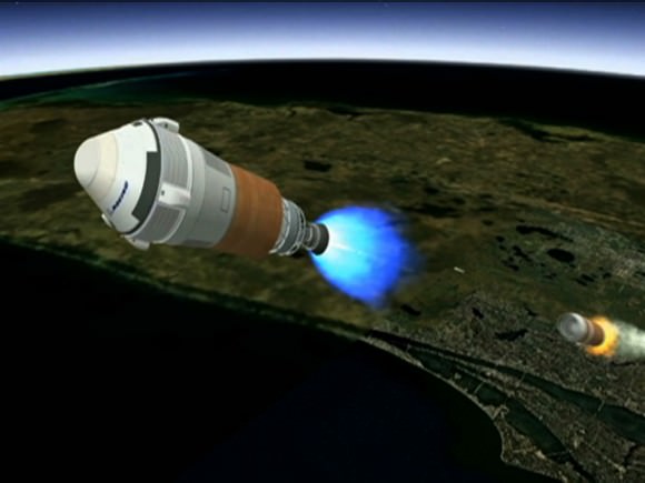
Artist’s concept shows Boeing’s CST-100 spacecraft separating from the first stage of its launch vehicle, a United Launch Alliance Atlas V rocket, following liftoff from Cape Canaveral Air Force Station in Florida. Credit: Boeing
But that date is dependent on funding from NASA and could easily be delayed by the ongoing sequester which has slashed NASA’s and all Federal budgets.
Chris Ferguson, the commander of the final shuttle flight (STS-135) by Atlantis, is leading Boeing’s flight test effort.
Boeing has leased one of NASA’s Orbiter Processing Facility hangers (OPF-3) at the Kennedy Space Center (KSC) for the manufacturing and assembly of its CST-100 spacecraft.
Mulholland told me previously that Boeing will ‘cut metal’ soon. “Our first piece of flight design hardware will be delivered to KSC and OPF-3 around mid 2013.”
NASA’s CCP program is fostering the development of the CST-100 as well as the SpaceX Dragon and Sierra Nevada Dream Chaser to replace the crew capability of NASA’s space shuttle orbiters.
The Atlas V will also serve as the launcher for the Sierra Nevada Dream Chaser space taxi.
Since the forced retirement of NASA’s shuttle fleet in 2011, US and partner astronauts have been 100% reliant on the Russians to hitch a ride to the ISS aboard the Soyuz capsules – at a price tag exceeding $60 Million per seat.
Simultaneously on a parallel track NASA is developing the Orion crew capsule and SLS heavy lift booster to send humans to the Moon and deep space destinations including Asteroids and Mars.
And don’t forget to “Send Your Name to Mars” aboard NASA’s MAVEN orbiter- details here. Deadline: July 1, 2013
…………….
Learn more about Conjunctions, Mars, Curiosity, Opportunity, MAVEN, LADEE and NASA missions at Ken’s upcoming lecture presentations:
June 4: “Send your Name to Mars” and “CIBER Astro Sat, LADEE Lunar & Antares ISS Rocket Launches from Virginia”; Rodeway Inn, Chincoteague, VA, 8:30 PM
NASA’s Curiosity Mars Science Laboratory (MSL) rover blasts off for Mars atop a stunningly beautiful Atlas V rocket on Nov. 26, 2011 at 10:02 a.m. EST from Cape Canaveral, Florida. United Launch Alliance (ULA) is now upgrading the Atlas V to launch humans aboard the Boeing CST-100 and Sierra Nevada Dream Chaser space taxis. Credit: Ken Kremer – kenkremer.comThe CST-100 spacecraft awaits liftoff aboard an Atlas V launch vehicle in this artist’s concept. Credit: Boeing
Opportunity established a new American driving record for a vehicle on another world on May 15, 2013 (Sol 3309) and made history by driving ahead from this point at Cape York. This navcam mosaic shows the view forward to her next destinations of Solander Point and Cape Tribulation along the lengthy rim of huge Endeavour crater spanning 14 miles (22 km) in diameter. Opportunity discovered clay minerals at Cape York and stands as the most favorable location for Martian biology discovered during her entire nearly 10 year long mission to Mars. Credit: NASA/JPL/Cornell/Kenneth Kremer/Marco Di Lorenzo
NASA’s Opportunity Mars rover discovered clay minerals at Cape York ridge along the rim of Endeavour crater – seen in this photo mosaic – which stands as the most favorable location for Martian biology discovered during her entire nearly 10 year long mission to Mars. Opportunity also established a new American driving record for a vehicle on another world on May 15, 2013 (Sol 3309) and made history by driving ahead from this point at Cape York. This navcam photo mosaic shows the view forward to her next destinations of Solander Point and Cape Tribulation along the lengthy rim of huge Endeavour crater spanning 14 miles (22 km) in diameter.
Credit: NASA/JPL/Cornell/Ken Kremer (kenkremer.com)/Marco Di Lorenzo Updated: Illustrated below with a collection of imagery, mosaics and route maps[/caption]
Now nearly a decade into her planned 3 month only expedition to Mars, NASA’s longest living rover Opportunity, struck gold and has just discovered the strongest evidence to date for an environment favorable to ancient Martian biology – and she has set sail hunting for a motherlode of new clues amongst fabulous looking terrain!!
Barely two weeks ago in mid-May 2013, Opportunity’s analysis of a new rock target named “Esperance” confirmed that it is composed of a “clay that had been intensely altered by relatively neutral pH water – representing the most favorable conditions for biology that Opportunity has yet seen in the rock histories it has encountered,” NASA said in a statement.
The finding of a fractured rock loaded with clay minerals and ravaged by flowing liquid water in which life could have thrived amounts to a scientific home run for the golf cart sized rover!
“Water that moved through fractures during this rock’s history would have provided more favorable conditions for biology than any other wet environment recorded in rocks Opportunity has seen,” said the mission’s principal investigator Prof. Steve Squyres of Cornell University, Ithaca, N.Y.
Opportunity accomplished the ground breaking new discovery by exposing the interior of Esperance with her still functioning Rock Abrasion Tool (RAT) and examining a pristine patch using the microscopic camera and X-Ray spectrometer on the end of her 3 foot long robotic arm.
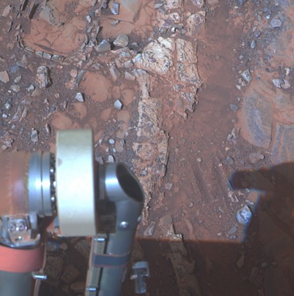
The pale rock in the upper center of this image, about the size of a human forearm, includes a target called “Esperance,” which was inspected by NASA’s Mars Exploration Rover Opportunity. Data from the rover’s alpha particle X-ray spectrometer (APXS) indicate that Esperance’s composition is higher in aluminum and silica, and lower in calcium and iron, than other rocks Opportunity has examined in more than nine years on Mars. Preliminary interpretation points to clay mineral content due to intensive alteration by water. Credit: NASA/JPL-Caltech/Cornell/Arizona State Univ
The robot made the discovery at the conclusion of a 20 month long science expedition circling around a low ridge called “Cape York” – which she has just departed on a southerly heading trekking around the eroded rim of the huge crater named “Endeavour.”
“Esperance was so important, we committed several weeks to getting this one measurement of it, even though we knew the clock was ticking.”
Esperance stems from a time when the Red Planet was far warmer and wetter billions of years ago.
“What’s so special about Esperance is that there was enough water not only for reactions that produced clay minerals, but also enough to flush out ions set loose by those reactions, so that Opportunity can clearly see the alteration,” said Scott McLennan of the State University of New York, Stony Brook, a long-term planner for Opportunity’s science team.
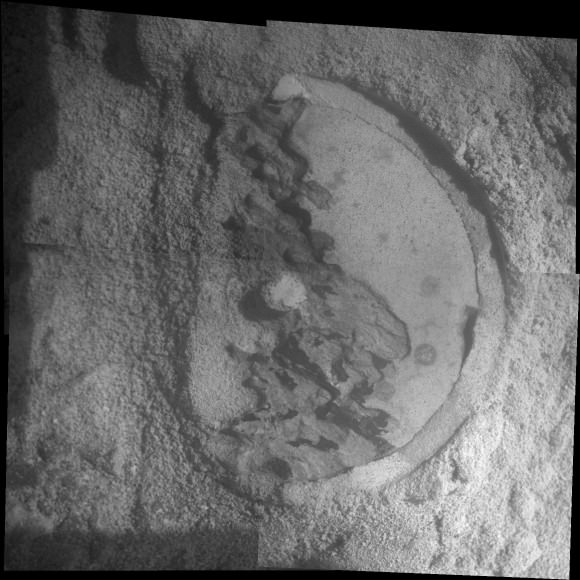
Close-Up of ‘Esperance’ After Abrasion by Opportunity This mosaic of four frames shot by the microscopic imager on the robotic arm of NASA’s Mars Exploration Rover Opportunity shows a rock target called “Esperance” after some of the rock’s surface had been removed by Opportunity’s rock abrasion tool, or RAT. The component images were taken on Sol 3305 on Mars (May 11, 2013). The area shown is about 2.4 inches (6 centimeters) across. Credit: NASA/JPL-Caltech/Cornell/USGS
Esperance is unlike any rock previously investigated by Opportunity; containing far more aluminum and silica which is indicative of clay minerals and lower levels of calcium and iron.
Most, but not all of the rocks inspected to date by Opportunity were formed in an environment of highly acidic water that is extremely harsh to most life forms.
Clay minerals typically form in potentially drinkable, neutral water that is not extremely acidic or basic.
Previously at Cape York, Opportunity had found another outcrop containing a small amount of clay minerals formed by exposure to water called “Whitewater Lake.”
“There appears to have been extensive, but weak, alteration of Whitewater Lake, but intense alteration of Esperance along fractures that provided conduits for fluid flow,” said Squyres.
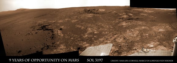
Opportunity rover discovered phyllosilicate clay minerals and calcium sulfate veins at the bright outcrops of ‘Whitewater Lake’, at right, imaged by the Navcam camera on Sol 3197 (Jan. 20, 2013, coinciding with her 9th anniversary on Mars. “Copper Cliff” is the dark outcrop, at top center. Darker “Kirkwood” outcrop, at left, is site of mysterious “newberries” concretions. This panoramic view was snapped from ‘Matijevic Hill’ on Cape York ridge at Endeavour Crater. Credit: NASA/JPL-Caltech/Cornell/Marco Di Lorenzo/Ken Kremer
Cape York is a hilly segment of the rim of Endeavour crater which spans 14 miles (22 km) across – where the robot arrived in mid-2011 and will spend her remaining life.
Opportunity has now set sail for her next crater rim destination named “Solander Point”, an area about 1.4 miles (2.2 kilometers) away – due south from “Cape York.”
“Our next destination will be Solander Point,” Squyres told Universe Today.
Along the way, Opportunity will soon cross “Botany Bay” and “Sutherland Point”, last seen when Opportunity first arrived at Cape York.
Eventually she will continue further south to a rim segment named ‘Cape Tribulation’ which holds huge caches of clay minerals.
The rover must arrive at “Solander Point” before the onset of her 6th Martian winter so that she can be advantageously tilted along north facing slopes to soak up the maximum amount of sun by her power generating solar wings. She might pull up around August.
On the other side of Mars, Opportunity’s new sister rover Curiosity also recently discovered clay minerals on the floor of her landing site inside Gale Crater.
Curiosity found the clay minerals – and a habitat that could support life – after analyzing powdery drill tailings from the Yellowknife Bay basin worksite with her on board state-of-the-art chemistry labs.
Just a week ago on May 15 (Sol 3309), Opportunity broke through the 40 year old American distance driving record set back in December 1972 by Apollo 17 astronauts Eugene Cernan and Harrison Schmitt.
But she is not sitting still resting on her laurels!
This past week the robots handlers’ back on Earth put the pedal to the metal and pushed her forward another quarter mile during 5 additional drives over 7 Sols, or Martian days. Thus her total odometry since landing on 24 January 2004 now stands at 22.45 miles (36.14 kilometers).
Opportunity will blast through the world record milestone of 23 miles (37 kilometers) held by the Lunokhod 2 lunar rover (from the Soviet Union), somewhere along the path to “Solander Point” in the coming months.
Opportunity captures the eerie Martian scenery looking south across Botany Bay from the southern tip of Cape York to her next destination – Solander Point, about 1 mile (1.6 km) away. This navcam photo mosaic was taken on Sol 3317, May 23, 2013. Credit: NASA/JPL/Cornell//Marco Di Lorenzo/Ken Kremer (kenkremer.com)
Endeavour Crater features terrain with older rocks than previously inspected and unlike anything studied before by Opportunity. It’s a place no one ever dared dream of reaching prior to Opportunity’s launch in the summer of 2003 and landing on the Meridiani Planum region in 2004.
Signatures of clay minerals, or phyllosilicates, were detected at several spots at Endeavour’s western rim by observations from the Compact Reconnaissance Imaging Spectrometer for Mars (CRISM) aboard NASA’s Mars Reconnaissance Orbiter (MRO).
“The motherlode of clay minerals is on Cape Tribulation. The exposure extends all the way to the top, mainly on the inboard side,” says Ray Arvidson, the rover’s deputy principal investigator at Washington University in St. Louis.
Stay tuned for the continuing breathtaking adventures of NASA’s sister rovers Opportunity and Curiosity!
And don’t forget to “Send Your Name to Mars” aboard NASA’s MAVEN orbiter- details here. Deadline: July 1, 2013
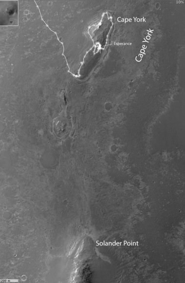
Traverse Map for NASA’s Opportunity rover from 2004 to 2013 to Record Setting Drive on May 15. This map shows the entire path the rover has driven during more than 9 years and over 3318 Sols, or Martian days, since landing inside Eagle Crater on Jan 24, 2004 to current location heading south to Solander Point from Cape York ridge at the western rim of Endeavour Crater. On May 15, 2013 Opportunity drove 263 feet (80 meters) southward – achieving a total traverse distance on Mars of 22.22 miles (35.76 kilometers) – and broke the driving record by any NASA vehicle that was previously held by the astronaut-driven Apollo 17 Lunar Rover in 1972. Credit: NASA/JPL/Cornell/ASU/Marco Di Lorenzo/Ken KremerOpportunity Heads Toward Next Destination, ‘Solander Point’ -This map of a portion of the western rim of Endeavour Crater on Mars shows the area where NASA’s Mars Exploration Rover Opportunity worked for 20 months, “Cape York,” in relation to the area where the rover team plans for Opportunity to spend its sixth Martian winter, “Solander Point.” Credit: NASA/JPL-Caltech/Univ. of Arizona
This time lapse mosaic shows Curiosity moving her robotic arm to drill into her 2nd rockt target named “Cumberland” to collect powdery material on May 19, 2013 (Sol 279) for analysis by her onboard chemistry labs; SAM & Chemin. The photomosaic was stitched from raw images captured by the navcam cameras on May 14 & May 19 (Sols 274 & 279). Credit: NASA/JPL-Caltech/Ken Kremer/Marco Di Lorenzo
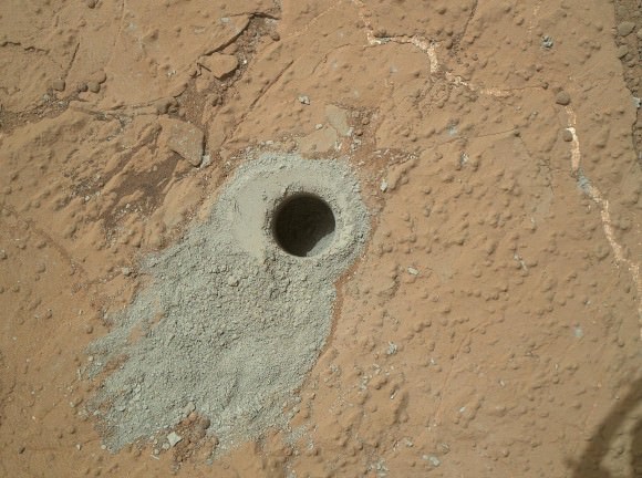
NASA’s Curiosity rover has just successfully bored inside ancient rocks on Mars for only the 2nd time since her nail biting landing in August 2012 inside Gale Crater as she searches for the ingredients of life.
On Sunday, May 20, the rover drilled about 2.6 inches (6.6 centimeters) deep into a target named “Cumberland” to collect powdery samples from the rock’s interior that hold the secrets to the history of water and habitability on the Red Planet.
“Cumberland” is literally just a stone’s throw away from the first drill target named “John Klein” where Curiosity bored the historic first drill hole on an alien world three months ago in February.
NASA’s Mars rover Curiosity drilled into this rock target, “Cumberland,” during the 279th Martian day, or sol, of the rover’s work on Mars (May 19, 2013) and collected a powdered sample of material from the rock’s interior. Analysis of the Cumberland sample using laboratory instruments inside Curiosity will check results from “John Klein,” the first rock on Mars from which a sample was ever collected and analyzed. The two rocks have similar appearance and lie about nine feet (2.75 meters) apart. Image Credit: NASA/JPL-Caltech/MSSS
Analysis of the gray colored, powdery “John Klein” sample by Curiosity’s pair of onboard chemistry labs – SAM & Chemin – revealed that this location on Mars was habitable in the past and possesses the key chemical ingredients required to support microbial life forms – thereby successfully accomplishing the key science objective of the mission and making a historic discovery.
The Cumberland powder will be fed into SAM and Chemin shortly through a trio of inlet ports on the rover deck.
‘Cumberland’ lies about nine feet (2.75 meters) west of ‘John Klein’. Both targets are inside the shallow depression named ‘Yellowknife Bay’ where Curiosity has been exploring since late 2012.
The six wheeled NASA robot arrived at Cumberland just last week on May 14 (Sol 274) after a pair of short drives.
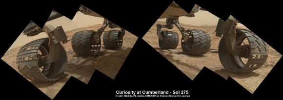
6 Wheels on Mars at “Cumberland” drill target is shown in this photo mosaic of Curiosity’s underbelly snapped on May 15, 2013 (Sol 275) after the rover drove about 9 feet (2.75 m) from the John Klein outcrop inside Yellowknife Bay. Credit: NASA/JPL-Caltech/Ken Kremer/Marco Di Lorenzo
The science team directed Curiosity to drill into ‘Cumberland’ to determine if it possesses the same ingredients found at “John Klein” and whether the habitable environment here is widespread and how long it existed in Mars’ history.
“We’ll drill another hole [at Cumberland] to confirm what we found in the John Klein hole,” said John Grotzinger to Universe Today. Grotzinger, of the California Institute of Technology in Pasadena, Calif., leads NASA’s Curiosity Mars Science Laboratory mission.
“The favorable conditions included the key elemental ingredients for life, an energy gradient that could be exploited by microbes, and water that was not harshly acidic or briny,” NASA said in a statement.
Panoramic view of Yellowknife Bay basin back dropped by Mount Sharp shows the location of the first two drill sites – John Klein & Cumberland – targeted by NASA’s Curiosity Mars rover. Curiosity accomplished historic 1st drilling into Martian rock at John Klein outcrop on Feb 8, 2013 (Sol 182) near where the robotic arm is touching the surface. This week the rover scooted about 9 feet to the right to Cumberland (right of center) for 2nd drill campaign on May 19, 2013 (Sol 279). Credit: NASA/JPL-Caltech/Ken Kremer/Marco Di Lorenzo
‘Cumberland’ and ‘John Klein’ are patches of flat-lying bedrock shot through with pale colored hydrated mineral veins composed of calcium sulfate and featuring a bumpy surface texture inside the ‘Yellowknife Bay’ basin that resembles a dried out lake bed.
“We have found a habitable environment [at John Klein] which is so benign and supportive of life that probably if this water was around, and you had been on the planet, you would have been able to drink it,” said Grotzinger.
Curiosity will remain at Cumberland for several weeks to fully characterize the area and then continue exploring several additional outcrops in and around Yellowknife Bay.
“After that we’re likely to begin the trek to Mt. Sharp, though we’ll stop quickly to look at a few outcrops that we passed by on the way into Yellowknife Bay,” Grotzinger told me.
One stop is likely to include the ‘Shaler’ outcrop of cross-bedding that was briefly inspected on the way in.
Thereafter the 1 ton rover will resume her epic trek to the lower reaches of mysterious Mount Sharp, the 3.5 mile (5.5 km) high layered mountain that dominates her landing site and is the ultimate driving goal inside Gale Crater.
And don’t forget to “Send Your Name to Mars” aboard NASA’s MAVEN orbiter- details here. Deadline: July 1, 2013
Video Caption: This JPL video shows the complicated choreography to get drill samples to Curiosity’s science instruments after completing 2nd drill campaign at “Cumberland.”


