First Interplanetary CubeSats to Launch on NASA’s 2016 InSight Mars Lander

NASA's two small MarCO CubeSats will be flying past Mars in 2016 just as NASA's next Mars lander, InSight, is descending to land on the surface. MarCO, for Mars Cube One, will provide an experimental communications relay to inform Earth quickly about the landing. Credits: NASA/JPL-Caltech

NASA’s two small MarCO CubeSats will be flying past Mars in 2016 just as NASA’s next Mars lander, InSight, is descending to land on the surface. MarCO, for Mars Cube One, will provide an experimental communications relay to inform Earth quickly about the landing. Credits: NASA/JPL-Caltech
See fly by and cubesat spacecraft graphics and photos below[/caption]

CubeSats are taking the next great leap for science – departing Earth and heading soon for the fourth rock from the Sun.

For the first time, two tiny CubeSat probes will launch into deep space in early 2016 on their first interplanetary expedition – aiming for the Red Planet as part of an experimental technology relay demonstration project aiding NASA’s next Mission to Mars; the InSight lander.

NASA announced the pair of briefcase-sized CubeSats, called Mars Cube One or MarCO, as a late and new addition to the InSight mission, that could substantially enhance communications options on future Mars missions. They were designed and built by NASA’s Jet Propulsion Laboratory (JPL), Pasadena, California.

InSight, which stands for Interior Exploration Using Seismic Investigations, Geodesy and Heat Transport, is a stationary lander. It will join NASA’s surface science exploration fleet currently comprising of the Curiosity and Opportunity missions which by contrast are mobile rovers.

InSight is the first mission to understand the interior structure of the Red Planet. Its purpose is to elucidate the nature of the Martian core, measure heat flow and sense for “Marsquakes.”

The full-scale mock-up of NASA's MarCO CubeSat held by Farah Alibay, a systems engineer for the technology demonstration, is dwarfed by the one-half-scale model of NASA's Mars Reconnaissance Orbiter behind her.  Credits: NASA/JPL-Caltech
The full-scale mock-up of NASA’s MarCO CubeSat held by Farah Alibay, a systems engineer for the technology demonstration, is dwarfed by the one-half-scale model of NASA’s Mars Reconnaissance Orbiter behind her. Credits: NASA/JPL-Caltech

Because of their small size – roughly 4 inches (10 centimeters) square) – and simplicity using off-the-shelf components, they are a favored platform for university students and others seeking low cost access to space – such as the Planetary Society’s recently successful Light Sail solar sailing cubesat demonstration launched in May. Six units are combined together to create MarCO.

Over the past few years many hundreds of cubesats have already been deployed in Earth orbit – including many dozens from the International Space Station (ISS) – but these will be the first going far beyond our Home Planet.

Data relayed by MarCO at 8 kbps in real time could reveal InSight’s fate on the Martian surface within minutes to mission controllers back on Earth, rather than waiting for a potentially prolonged period of agonizing nail-biting lasting an hour or more.

The two probes, known as MarCO-A and MarCO-B, will operate during InSight’s highly complex entry, descent and landing (EDL) operations as it descends through the thin Martian atmosphere. Their function is merely to quickly relay landing data. But the cubesats will have no impact on the ultimate success of the mission. They will intentionally sail by but not land on Mars.

“MarCO is an experimental capability that has been added to the InSight mission, but is not needed for mission success,” said Jim Green, director of NASA’s planetary science division at the agency’s headquarters in Washington, in a statement.

The MarCO Cubesats will serve as a test bed for a revolutionary communications mode that seeks to quickly relay data back to Earth about the status of InSight – in real time – as it plummets down to the Red Planet for the “Seven Minutes of Terror” that hopefully climaxes with a soft landing.

The MarCO duo will fly by past Mars at a planned distance and altitude of about 3,500 kilometers as InSight descends towards the surface during EDL operations. They will rapidly retransmit signals coming from the lander in real time, directly back to NASA’s huge Deep Space Network (DSN) receiving dish antennas back on Earth.

 MarCO cubesats fly by trajectory for rapid communications relay as NASA’s InSight spacecraft lands on Mars in September 2016. Credit: NASA/JPL-Caltech

MarCO cubesats fly by trajectory for rapid communications relay as NASA’s InSight spacecraft lands on Mars in September 2016. Credit: NASA/JPL-Caltech

For this flight, six cubesats will be joined together to provide the additional capability required for the journey to Mars and to accomplish their communications task.

The six-unit MarCO CubeSat has a stowed size of about 14.4 inches (36.6 centimeters) by 9.5 inches (24.3 centimeters) by 4.6 inches (11.8 centimeters) and weighs 14 kilograms.

The solar powered probes will be outfitted with UHF and X-band communications gear as well as propulsion, guidance and more.

The overall cost to design, build, launch and operate MarCO-A and MarCO-B is approximately $13 million, a NASA spokesperson told Universe Today.

InSight and MarCO are slated to blastoff together on March 4, 2016 atop a United Launch Alliance Atlas V rocket from Vandenberg Air Force Base, California.

After launch, both MarCO CubeSats will separate from the Atlas V booster and travel along their own trajectories to the Red Planet.

“MarCO will fly independently to Mars,” says Green.

They will be navigated independently from InSight. They will all reach Mars at approximately the same time for InSight’s landing slated for Sept. 28, 2016.

MarCO’s two solar panels and two radio antennas will unfurl after being released from the Atlas booster. The high-gain, X-band antenna is a flat panel engineered to direct radio waves the way a parabolic dish antenna does,” according to a NASA description.

The softball-size radio “provides both UHF (receive only) and X-band (receive and transmit) functions capable of immediately relaying information received over UHF.”

MarCO cubesat graphic annotated to show dimensions, instruments, physical characteristics and capabilities.  Credit: NASA/JPL-Caltech
MarCO cubesat graphic annotated to show dimensions, instruments, physical characteristics and capabilities. Credit: NASA/JPL-Caltech

During EDL, InSight will transmit landing data via UHF radio to the MarCO cubesats sailing past Mars as well as to NASA’s Mars Reconnaissance Orbiter (MRO) soaring overhead.

MarCO will assist InSight by receiving the lander information transmitted in the UHF radio band and then immediately forward EDL information to Earth using the X-band radio. By contrast, MRO cannot simultaneously receive information over one band while transmitting on another, thus delaying confirmation of a successful landing possibly by an hour or more.

Engineers for NASA's MarCO technology demonstration display a full-scale mechanical mock-up of the small craft in development as part of NASA's next mission to Mars. Mechanical engineer Joel Steinkraus and systems engineer Farah Alibay are on the team at NASA's Jet Propulsion Laboratory, Pasadena, California, preparing twin MarCO (Mars Cube One) CubeSats for a March 2016 launch.  Credit: NASA/JPL-Caltech
Engineers for NASA’s MarCO technology demonstration display a full-scale mechanical mock-up of the small craft in development as part of NASA’s next mission to Mars. Mechanical engineer Joel Steinkraus and systems engineer Farah Alibay are on the team at NASA’s Jet Propulsion Laboratory, Pasadena, California, preparing twin MarCO (Mars Cube One) CubeSats for a March 2016 launch. Credit: NASA/JPL-Caltech

“Ultimately, if the MarCO demonstration mission succeeds, it could allow for a “bring-your-own” communications relay option for use by future Mars missions in the critical few minutes between Martian atmospheric entry and touchdown,” say NASA officials.

It’s also very beneficial and critical to the success of future missions to have a stream of data following the progress of past missions so that lessons can be learned and applied, whatever the outcome.

“By verifying CubeSats are a viable technology for interplanetary missions, and feasible on a short development timeline, this technology demonstration could lead to many other applications to explore and study our solar system,” says NASA.

InSight will smash into the Martian atmosphere at high speeds of approximately 13,000 mph in September 2016 and then decelerate within a few minutes for landing via a heat shield, retro rocket and parachute assisted touchdown on the plains at flat-lying terrain at “Elysium Planitia,” some four degrees north of Mars’ equator, and a bit north of the Curiosity rover.

As I reported in recently here, InSight has now been assembled into its flight configuration and begun a comprehensive series of rigorous environmental stress tests that will pave the path to launch in 2016 on a mission to unlock the riddles of the Martian core.

The countdown clock is ticking relentlessly towards liftoff in less than nine months time in March 2016.

NASA's InSight Mars lander spacecraft in a Lockheed Martin clean room near Denver. As part of a series of deployment tests, the spacecraft was commanded to deploy its solar arrays in the clean room to test and verify the exact process that it will use on the surface of Mars.  Credits: NASA/JPL-Caltech/Lockheed Martin
NASA’s InSight Mars lander spacecraft in a Lockheed Martin clean room near Denver. As part of a series of deployment tests, the spacecraft was commanded to deploy its solar arrays in the clean room to test and verify the exact process that it will use on the surface of Mars. Credits: NASA/JPL-Caltech/Lockheed Martin

Stay tuned here for Ken’s continuing Earth and planetary science and human spaceflight news.

Ken Kremer

Dawn Does Dramatic Fly Over of Ceres, Enters Lower Mapping Orbit: Video

This image of Ceres was taken by NASA's Dawn spacecraft on May 7, 2015, from a distance of 8,400 miles (13,600 kilometers). Credit: NASA/JPL-Caltech/UCLA/MPS/DLR/IDA

Video caption: This new video animation of Ceres was created from images taken by NASA’s Dawn spacecraft at altitudes of 8,400 miles (13,600 kilometers) and 3,200 miles (5,100 kilometers) away. Vertical dimension has been exaggerated by a factor of two and a star field added. Credit: NASA/JPL-Caltech/UCLA/MPS/DLR/IDA

Scientists leading NASA’s Dawn mission to dwarf planet Ceres have just released a brand new animated video showing a dramatic fly over of the heavily cratered world featuring its mysterious bright spots whose exact origin and nature remain elusive.

Meanwhile, the venerable probe has just successfully entered its new and lower mapping orbit on June 3 from which researchers hope to glean hordes of new data to unravel the secrets of the bright spots and unlock the nature of Ceres origin and evolution.

Pockmarked Ceres is an alien world unlike any other in our solar system.

“Dawn completed the maneuvering to reach its second mapping orbit and stopped ion-thrusting on schedule. Since May 9, the spacecraft has reduced its orbital altitude from 8,400 miles (13,600 kilometers) to 2,700 miles (4,400 kilometers),” reported Marc Rayman, Dawn Chief Engineer/ Mission Director of NASA’s Jet Propulsion Laboratory, Pasadena, California.

“As Dawn flew 2,700 miles (4,400 kilometers) over Ceres’ north pole on June 5 that marked the beginning of the new mapping phase, and Dawn began taking photos and making other measurements on schedule.”

Each orbit of Dawn around Ceres at this second science mapping orbit lasts 3.1 days.

The new video was created by the research team based on observations of Ceres that were taken from Dawn’s initial mapping orbit, at an altitude of 8,400 miles (13,600 kilometers), as well as the most recent navigational images taken from 3,200 miles (5,100 kilometers), according to NASA.

It is based on data from over 80 images captured by Dawn’s framing cameras which were provided The German Aerospace Center (DLR) and Max Planck Institute for Solar System Research in Göttingen, Germany.

The images were used to provide a three-dimensional video view. The vertical dimension is exaggerated by a factor of two in the video.

“We used a three-dimensional terrain model that we had produced based on the images acquired so far,” said Dawn team member Ralf Jaumann of the German Aerospace Center (DLR), in Berlin.

“They will become increasingly detailed as the mission progresses — with each additional orbit bringing us closer to the surface.”

Imagery of the mysterious bright spots show them to seemingly be sheets of many spots of water ice, and not just single huge patches. The famous duo of ice spots are located inside the middle of a 57 miles (92 kilometers) wide crater situated in Ceres northern hemisphere.

Dawn is an international science mission managed by NASA’s Jet Propulsion Laboratory, Pasadena, California. The trio of science instruments are from the US, Germany and Italy.

The framing camera was provided by the Max Planck Institute for Solar System Research, Göttingen, Germany and the German Aerospace Center (DLR).

This view of Ceres was taken by Dawn spacecraft on May 23 and shows finer detail becoming visible on the dwarf planet. The spacecraft snapped the image at a distance of 3,200 miles (5,100 kilometers) with a resolution of 1,600 feet (480 meters) per pixel. Credit: NASA/JPL-Caltech/UCLA/MPS/DLR/IDA

Dawn will spend most if June at this second mapping orbit before firing up the ion engines and spiraling yet lower for a mission expected to last until at least June 2016.

Stay tuned here for Ken’s continuing Earth and planetary science and human spaceflight news.

Ken Kremer

Dawn’s spiral descent from its first mapping orbit (RC3) to its second (survey). The two mapping orbits are shown in green. The color of Dawn’s trajectory progresses through the spectrum from blue, when it began ion-thrusting on May 9, to red, when ion-thrusting concludes on June 3. The red dashed sections show where Dawn is coasting, mostly for telecommunications. The first two coast periods include OpNav 8 and 9. Image credit: NASA/JPL-Caltech

Rosetta Discovery of Surprise Molecular Breakup Mechanism in Comet Coma Alters Perceptions

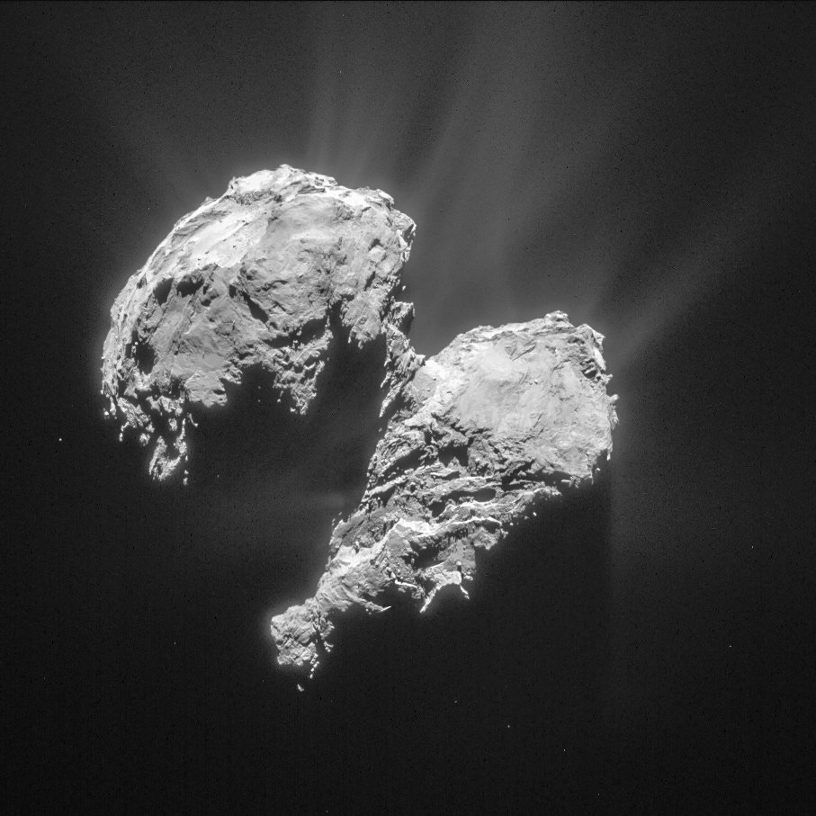
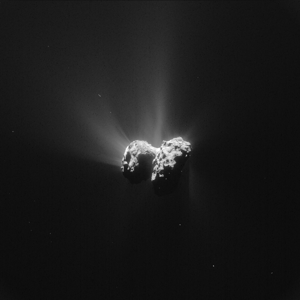
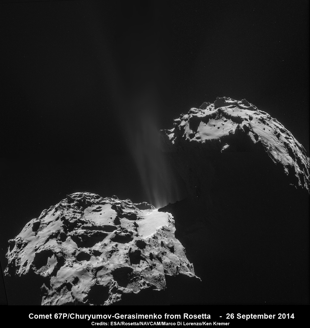
This single frame Rosetta navigation camera image was taken from a distance of 77.8 km from the centre of Comet 67P/Churyumov-Gerasimenko on 22 March 2015. The image has a resolution of 6.6 m/pixel and measures 6 x 6 km. The image is cropped and processed to bring out the details of the comet’s activity. Credit: ESA/Rosetta/NAVCAM – CC BY-SA IGO 3.0

A NASA science instrument flying aboard the European Space Agency’s (ESA) Rosetta spacecraft has made a very surprising discovery – namely that the molecular breakup mechanism of “water and carbon dioxide molecules spewing from the comet’s surface” into the atmosphere of comet 67P/Churyumov-Gerasimenko is caused by “electrons close to the surface.”

The surprising results relating to the emission of the comet coma came from measurements gathered by the probes NASA funded Alice instrument and is causing scientists to completely rethink what we know about the wandering bodies, according to the instruments science team.

“The discovery we’re reporting is quite unexpected,” said Alan Stern, principal investigator for the Alice instrument at the Southwest Research Institute (SwRI) in Boulder, Colorado, in a statement.

“It shows us the value of going to comets to observe them up close, since this discovery simply could not have been made from Earth or Earth orbit with any existing or planned observatory. And, it is fundamentally transforming our knowledge of comets.”

A paper reporting the Alice findings has been accepted for publication by the journal Astronomy and Astrophysics, according to statements from NASA and ESA.

Alice is a spectrograph that focuses on sensing the far-ultraviolet wavelength band and is the first instrument of its kind to operate at a comet.

Until now it had been thought that photons from the sun were responsible for causing the molecular breakup, said the team.

The carbon dioxide and water are being released from the nucleus and the excitation breakup occurs barely half a mile above the comet’s nucleus.

“Analysis of the relative intensities of observed atomic emissions allowed the Alice science team to determine the instrument was directly observing the “parent” molecules of water and carbon dioxide that were being broken up by electrons in the immediate vicinity, about six-tenths of a mile (one kilometer) from the comet’s nucleus.”

The excitation mechanism is detailed in the graphic below.

Rosetta’s continued close study of Comet 67P/Churyumov-Gerasimenko has revealed an unexpected process at work close to the comet nucleus that causes the rapid breakup of water and carbon dioxide molecules.   Credits: ESA/ATG medialab; ESA/Rosetta/MPS for OSIRIS Team MPS/UPD/LAM/IAA/SSO/INTA/UPM/DASP/IDA; ESA/Rosetta/NavCam – CC BY-SA IGO 3.0
Rosetta’s continued close study of Comet 67P/Churyumov-Gerasimenko has revealed an unexpected process at work close to the comet nucleus that causes the rapid breakup of water and carbon dioxide molecules. Credits: ESA/ATG medialab; ESA/Rosetta/MPS for OSIRIS Team MPS/UPD/LAM/IAA/SSO/INTA/UPM/DASP/IDA; ESA/Rosetta/NavCam – CC BY-SA IGO 3.0

“The spatial variation of the emissions along the slit indicates that the excitation occurs within a few hundred meters of the surface and the gas and dust production are correlated,” according to the Astronomy and Astrophysics journal paper.

The data shows that the water and CO2 molecules break up via a two-step process.

“First, an ultraviolet photon from the Sun hits a water molecule in the comet’s coma and ionises it, knocking out an energetic electron. This electron then hits another water molecule in the coma, breaking it apart into two hydrogen atoms and one oxygen, and energising them in the process. These atoms then emit ultraviolet light that is detected at characteristic wavelengths by Alice.”

“Similarly, it is the impact of an electron with a carbon dioxide molecule that results in its break-up into atoms and the observed carbon emissions.”

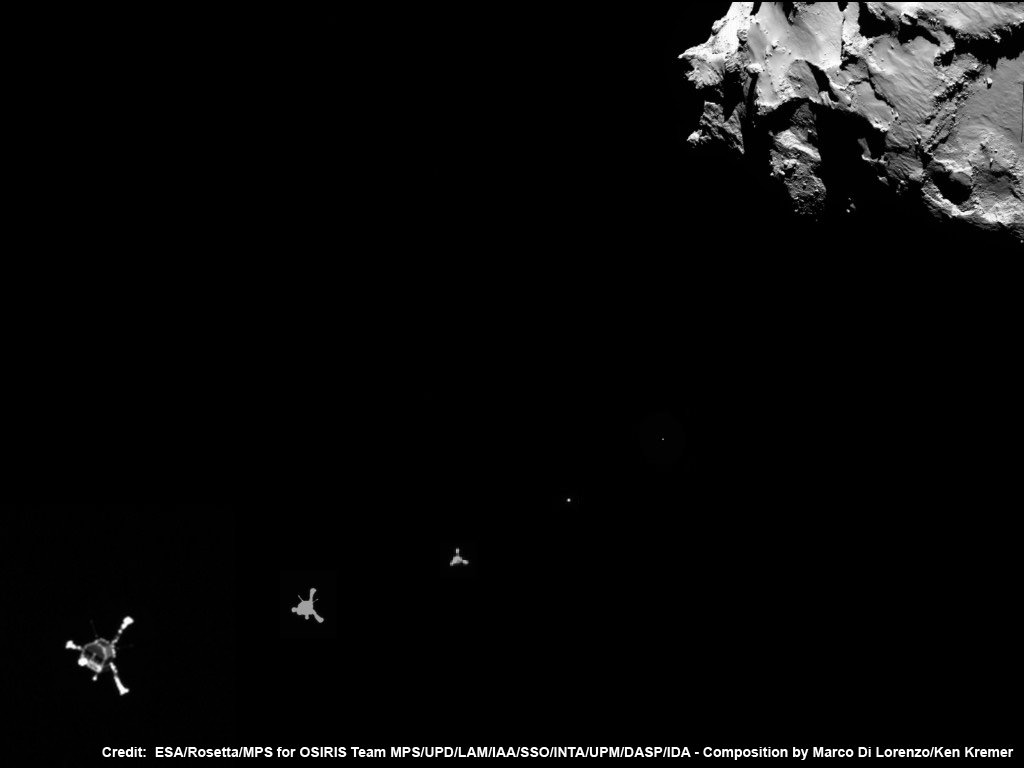
After a decade long chase of over 6.4 billion kilometers (4 Billion miles), ESA’s Rosetta spacecraft arrived at the pockmarked Comet 67P/Churyumov-Gerasimenko on Aug. 6, 2014 for history’s first ever attempt to orbit a comet for long term study.
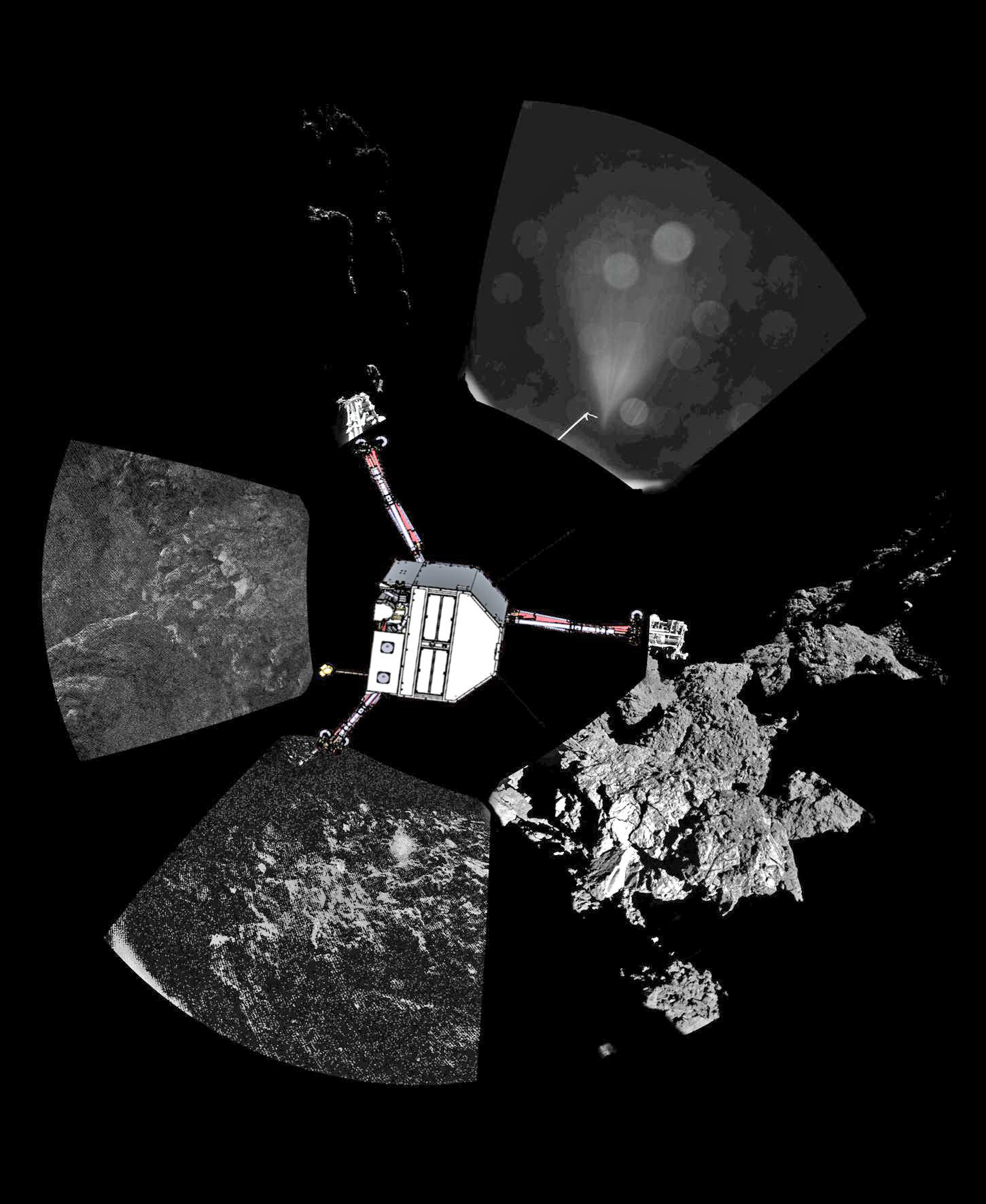
Since then, Rosetta deployed the Philae landing craft to accomplish history’s first ever touchdown on a comets nucleus. It has also orbited the comet for over 10 months of up close observation, coming at times to as close as 8 kilometers. It is equipped with a suite 11 instruments to analyze every facet of the comet’s nature and environment.

Comet 67P is still becoming more and more active as it orbits closer and closer to the sun over the next two months. The pair reach perihelion on August 13, 2015 at a distance of 186 million km from the Sun, between the orbits of Earth and Mars.

Alice works by examining light emitted from the comet to understand the chemistry of the comet’s atmosphere, or coma and determine the chemical composition with the far-ultraviolet spectrograph.

According to the measurements from Alice, the water and carbon dioxide in the comet’s atmospheric coma originate from plumes erupting from its surface.

“It is similar to those that the Hubble Space Telescope discovered on Jupiter’s moon Europa, with the exception that the electrons at the comet are produced by solar radiation, while the electrons at Europa come from Jupiter’s magnetosphere,” said Paul Feldman, an Alice co-investigator from the Johns Hopkins University in Baltimore, Maryland, in a statement.

Jets of gas and dust are blasting from the active neck of comet 67P/Churyumov-Gerasimenko in this photo mosaic assembled from four images taken on 26 September 2014 by the European Space Agency’s Rosetta spacecraft at a distance of 26.3 kilometers (16 miles) from the center of the comet. Credit: ESA/Rosetta/NAVCAM/Marco Di Lorenzo/Ken Kremer/kenkremer.com
Rosetta discovered an unexpected process at comet nucleus that causes the rapid breakup of water and carbon dioxide molecules. Jets of gas and dust are blasting from the active neck of comet 67P/Churyumov-Gerasimenko in this photo mosaic assembled from four images taken on 26 September 2014 by the European Space Agency’s Rosetta spacecraft at a distance of 26.3 kilometers (16 miles) from the center of the comet. Credit: ESA/Rosetta/NAVCAM/Marco Di Lorenzo/Ken Kremer/kenkremer.com

Other instruments aboard Rosetta including MIRO, ROSINA and VIRTIS, which study relative abundances of coma constituents, corroborate the Alice findings.

“These early results from Alice demonstrate how important it is to study a comet at different wavelengths and with different techniques, in order to probe various aspects of the comet environment,” says ESA’s Rosetta project scientist Matt Taylor, in a statement.

“We’re actively watching how the comet evolves as it moves closer to the Sun along its orbit towards perihelion in August, seeing how the plumes become more active due to solar heating, and studying the effects of the comet’s interaction with the solar wind.”

Stay tuned here for Ken’s continuing Earth and planetary science and human spaceflight news.

Ken Kremer

The Martian Curiosity Looks Back on 1000 Sols of Exploration on the Red Planet

NASA’s Martian Curiosity rover looks backs to 1000 Sols of science and exploration on the surface of the Red Planet. Robot wheel tracks lead back through valley dunes. Gale Crater rim seen in the distant hazy background. Sol 997 (May 28, 2015) navcam camera raw images stitched and colorized. Credit: NASA/JPL-Caltech/ Marco Di Lorenzo/Ken Kremer/kenkremer.com Featured on APOD on June 13, 2015

Looking back 1000 Sols on the Red Planet
NASA’s Martian Curiosity rover looks backs to 1000 Sols of science and exploration on the surface of the Red Planet. Robot wheel tracks lead back through valley dunes. Gale Crater rim seen in the distant hazy background. Sol 997 (May 28, 2015) navcam camera raw images stitched and colorized. Credit: NASA/JPL-Caltech/ Marco Di Lorenzo/Ken Kremer/kenkremer.com
Featured on APOD on June 13, 2015
Story updated[/caption]

The Martian Curiosity celebrates 1000 Sols on Mars!

Marking the occasion with utter glee, the car sized robot snapped a cool mosaic view (above) looking back to 1000 Sols of high impact exploration and discovery on the Red Planet, showing her wheel tracks leading back through valley dunes from the foothills of humongous Mount Sharp and across the alien surface floor and out to the distant rim of the Gale Crater landing site she descended to nearly three years ago in August 2012.

“A thousand thanks to the best team a rover could have. Celebrating 1,000 sols. Here’s to the Martian days ahead!” the robot tweeted.

But at 1K sols she’s not content to just bask in the Martian sunshine during the history making event. Rather, she is as always hard at work, reaching out with the high tech robotic arm and inspecting intriguing rock outcrops spread out all around her.

Check out Curiosity’s current workspace, looking back and hard at work in our new photo mosaics herein created by the imaging team of Marco Di Lorenzo and Ken Kremer. They are also featured at NBC News – here – and Alive Space Images (in Italian) – here and here.

Curiosity rover at work for 1000 Sols on Mars.  This composite multi sol photo mosaic shows outstretched robotic arm inspecting intriguing rock outcrops.   The APXS spectrometer is investigating a target called ‘Ronan’ on the Stimson overlying outcrop.   Navcam camera raw images taken from sols 997 to 1000 are stitched and colorized.  Credit: NASA/JPL/Ken Kremer/kenkremer.com/Marco Di Lorenzo
Curiosity rover at work for 1000 Sols on Mars
This composite multi sol photo mosaic shows outstretched robotic arm inspecting intriguing rock outcrops. The APXS spectrometer is investigating a target called ‘Ronan’ on the Stimson overlying outcrop. Navcam camera raw images taken from sols 997 to 1000 are stitched and colorized. Credit: NASA/JPL/Ken Kremer/kenkremer.com/Marco Di Lorenzo

The raw images for the look back mosaic were taken after she arrived at her current location on Martian Sol 997, or Earth’s Day May 28, 2015.

The Curiosity Mars Science Laboratory (MSL) rover officially celebrated 1000 Martian Sols on May 31, 2015 since she safely touched down on the crater floor on August 5, 2012 following the nail-biting and unprecedented sky crane maneuver that delivered her with pinpoint precision to a landing site nearby Mount Sharp.

“An MSL landmark day. We have reached 1000 sols on Mars. Looking back the remarkable thing is how few serious problems there have been,” says team member Professor John Bridges of the University of Leicester, England, in an update.

Exploring the sedimentary layers of Mount Sharp, which towers 3.4 miles (5.5 kilometers) into the Martian sky, form the primary destination and goal of her scientific expedition.

The six wheeled robot and her team of handlers back on Earth, are eeking out every last drop of science before she and all of Earth’s entire Martian invasion fleet enter solar conjunction, when Mars is behind the sun and little or no communications will be possible for most of the month of June. Activities will be limited per safety protocols.

“However, there is one issue even Curiosity can’t avoid – Conjunction. For much of June, Mars will be obscured from Earth by the Sun. Few science operations,” explains Bridges.

Curiosity rover rolls across Mars at the foothills of Mount Sharp, seen in the background, in this mosaic of images taken on April 11, 2015 (Sol 952).  Navcam camera raw images stitched and colorized. Credit:  NASA/JPL-Caltech/ Marco Di Lorenzo/Ken Kremer/kenkremer.com
Curiosity rover rolls across Mars at the foothills of Mount Sharp, seen in the background, in this mosaic of images taken on April 11, 2015 (Sol 952). Navcam camera raw images stitched and colorized. Credit: NASA/JPL-Caltech/ Marco Di Lorenzo/Ken Kremer/kenkremer.com

NASA’s long-lived Opportunity rover labors on the opposite side of Mars.

After a short drive Curiosity arrived at her current location at “Marias Pass” on Sol 997, where she will stay stationary during the conjunction period out of an abundance of caution.

“A short bump on Sol 997 put Curiosity in a great position to investigate a few different rock units in Marias Pass, using the instruments on the rover’s arm,” wrote MSL and USGS mission scientist Ken Herkenhoff in an update.

She also reached within an eyelash of 10.6 kilometers (6.6 mi) of total driving.

“The 2.5 m drive brings our total odometry to 10,599 m,” noted Herkenoff.

Along the way she discovered the chemical ingredient minerals necessary to support life, as well as low levels of some organic molecules and some traces of methane, and and ample evidence for lakes and streams of liquid water.

“Curiosity is now parked for the next few weeks. But we are parked in front of a beautiful outcrop that shows the contact between the underlying Pahrump unit and the overlying Stimson unit.”

Our arm photo mosaic herein shows the seven foot (2 m) long robotic arm and its APXS spectrometer deployed at the target called “Ronan”, which is part of the overlying Stimson outcrop unit.

The rover is also using the ChemCam, MastCam and MAHLI cameras and spectrometers and other instruments to characterize the outcrop and its texture and composition in detail.

The robotic arm will be stowed during the June conjunction period.

Curiosity arrived at the Pahrump Hills at the base of Mount Sharp back in September 2014. Since then she has conducted an intensive investigation of the rocks and a trio of drilling operations to elucidate how this area fits in context with Mount Sharp and the habitable region discovered on the crater floor at Yellowknife Bay back in the spring of 2013.

In recent weeks, Curiosity has been driving up hills with slopes of as much as 21 degrees, higher than ever before, on an exciting journey endeavoring to slowly ascend up to the lower layers of Mount Sharp.

The current Martian outcrop area under investigation is a place where two distinctive geologic types of bedrock meet and where pale rock meets darker overlying rock.

“Such contacts can reveal clues about how the environmental conditions that produced one type of rock were related to the conditions that produced the other,” says NASA.

“The rover science team wants to examine an outcrop that contains the contact between the pale rock unit the mission analyzed lower on Mount Sharp and a darker, bedded rock unit that the mission has not yet examined up close.”

The team is also scouting around for the presence of mineral veins, like those recently discovered at the “Garden City” outcrop, that formed in the past during periods of flowing liquid water that could be favorable for microbial life forms if they ever existed.

Curiosity investigates a beautiful outcrop of scientifically enticing dark and light mineral veins at ”Garden City” outcrop at the base of Mount Sharp at current location on Mars.   This  photo mosaic was stitched  from Mastcam color camera raw images. Credit:  NASA/JPL-Caltech/MSSS/Ken Kremer/kenkremer.com/Marco Di Lorenzo
Curiosity investigates a beautiful outcrop of scientifically enticing dark and light mineral veins at ”Garden City” outcrop at the base of Mount Sharp at current location on Mars. This photo mosaic was stitched from Mastcam color camera raw images. Credit: NASA/JPL-Caltech/MSSS/Ken Kremer/kenkremer.com/Marco Di Lorenzo

Because there’s a plethora of treacherous dunes, the team has had to monitor operations carefully and alter the route on occasion to maintain safe operations.

Curiosity has already accomplished her primary objective of discovering a habitable zone on the Red Planet that contains the minerals necessary to support microbial life in the ancient past when Mars was far wetter and warmer billions of years ago.

This March 6, 2015 (Sol 917), mosaic of images from the Navcam camera on NASA's Curiosity Mars rover shows the position in which the rover held its arm for several days after a transient short circuit triggered onboard fault-protection programming to halt arm activities on Feb. 27, 2015, Sol 911.  The rover team chose to hold the arm in the same position for several days of tests to diagnose the underlying cause of the Sol 911 event.  Navcam camera raw images stitched and colorized. Credit:  NASA/JPL-Caltech/Ken Kremer/kenkremer.com/Marco Di Lorenzo
This March 6, 2015 (Sol 917), mosaic of images from the Navcam camera on NASA’s Curiosity Mars rover shows the position in which the rover held its arm for several days after a transient short circuit triggered onboard fault-protection programming to halt arm activities on Feb. 27, 2015, Sol 911. The rover team chose to hold the arm in the same position for several days of tests to diagnose the underlying cause of the Sol 911 event. Navcam camera raw images stitched and colorized. Credit: NASA/JPL-Caltech/Ken Kremer/kenkremer.com/Marco Di Lorenzo

To date, Curiosity’s odometer totals over 5.1 miles (8.4 kilometers) since landing inside Gale Crater on Mars in August 2012.

As of today, Sol 1001, June 1, 2015, she has taken over 246,000 amazing images.

Stay tuned here for Ken’s continuing Earth and planetary science and human spaceflight news.

Ken Kremer

NASA’s Journey to Mars Ramps Up with InSight, Key Tests Pave Path to 2016 Lander Launch

NASA's InSight Mars lander spacecraft in a Lockheed Martin clean room near Denver. As part of a series of deployment tests, the spacecraft was commanded to deploy its solar arrays in the clean room to test and verify the exact process that it will use on the surface of Mars. Credits: NASA/JPL-Caltech/Lockheed Martin

NASA’s ‘Journey to Mars’ is ramping up significantly with ‘InSight’ – as the agency’s next Red Planet lander has now been assembled into its flight configuration and begun a comprehensive series of rigorous and critical environmental stress tests that will pave the path to launch in 2016 on a mission to unlock the riddles of the Martian core.

The countdown clock is ticking relentlessly and in less than nine months time, NASA’s InSight Mars lander is slated to blastoff in March 2016.

InSight, which stands for Interior Exploration Using Seismic Investigations, Geodesy and Heat Transport, is a stationary lander. It will join NASA’s surface science exploration fleet currently comprising of the Curiosity and Opportunity missions which by contrast are mobile rovers.

But before it will even be allowed to get to the launch pad, the Red Planet explorer must first prove its mettle and show that it can operate in and survive the harsh and unforgiving rigors of the space environment via a battery of prelaunch tests. That’s an absolute requirement in order for it to successfully carry out its unprecedented mission to investigate Mars deep interior structure.

InSight’s purpose is to elucidate the nature of the Martian core, measure heat flow and sense for “Marsquakes.” These completely new research findings will radically advance our understanding of the early history of all rocky planets, including Earth and could reveal how they formed and evolved.

“Today, our robotic scientific explorers are paving the way, making great progress on the journey to Mars,” said Jim Green, director of NASA’s Planetary Science Division at the agency’s headquarters in Washington, in a statement.

“Together, humans and robotics will pioneer Mars and the solar system.”

The science deck of NASA's InSight lander is being turned over in this April 29, 2015, photo from InSight assembly and testing operations inside a clean room at Lockheed Martin Space Systems, Denver.  The large circular component on the deck is the protective covering to be placed over InSight's seismometer after the seismometer is placed directly onto the Martian ground.   Credits: NASA/JPL-Caltech/Lockheed Martin
The science deck of NASA’s InSight lander is being turned over in this April 29, 2015, photo from InSight assembly and testing operations inside a clean room at Lockheed Martin Space Systems, Denver. The large circular component on the deck is the protective covering to be placed over InSight’s seismometer after the seismometer is placed directly onto the Martian ground. Credits: NASA/JPL-Caltech/Lockheed Martin

The launch window for InSight opens on March 4 and runs through March 30, 2016.

InSight will launch atop a United Launch Alliance (ULA) Atlas V rocket from Vandenberg Air Force Base, California.

InSight counts as NASA’s first ever interplanetary mission to launch from California.

The car sized probe will touch down near the Martian equator about six months later in the fall of 2016.

The prime contractor for InSight is Lockheed Martin Space Systems in Denver, Co and the engineering and technical team recently finished assembling the lander into its final configuration.

So now the time has begun to start the shakedown that literally involve “shaking and baking and zapping” the spacecraft to prove its ready and able to meet the March 2016 launch deadline.

During the next seven months of environmental testing at Lockheed’s Denver facility, “the lander will be exposed to extreme temperatures, vacuum conditions of nearly zero air pressure simulating interplanetary space, and a battery of other tests.”

“The assembly of InSight went very well and now it’s time to see how it performs,” said Stu Spath, InSight program manager at Lockheed Martin Space Systems, Denver, in a statement.

“The environmental testing regimen is designed to wring out any issues with the spacecraft so we can resolve them while it’s here on Earth. This phase takes nearly as long as assembly, but we want to make sure we deliver a vehicle to NASA that will perform as expected in extreme environments.”

The first test involves “a thermal vacuum test in the spacecraft’s “cruise” configuration, which will be used during its seven-month journey to Mars. In the cruise configuration, the lander is stowed inside an aeroshell capsule and the spacecraft’s cruise stage – for power, communications, course corrections and other functions on the way to Mars — is fastened to the capsule.”

After the vacuum test, InSight will be subjected to a series of tests simulating the vibrations of launch, separation and deployment shock, as well as checking for electronic interference between different parts of the spacecraft and compatibility testing.

Finally, a second thermal vacuum test will expose the probe “to the temperatures and atmospheric pressures it will experience as it operates on the Martian surface.”

The $425 million InSight mission is expected to operate for about two years on the Martian surface.

Artist rendition of NASA’s Mars InSight (Interior exploration using Seismic Investigations, Geodesy and Heat Transport) Lander. InSight is based on the proven Phoenix Mars spacecraft and lander design with state-of-the-art avionics from the Mars Reconnaissance Orbiter (MRO) and Gravity Recovery and Interior Laboratory (GRAIL) missions. Credit: JPL/NASA

InSight is an international science mission and a near duplicate of NASA’s successful Phoenix Mars landing spacecraft, Bruce Banerdt, InSight Principal Investigator of NASA’s Jet Propulsion Laboratory (JPL), Pasadena, California, told Universe Today.

“InSight is essentially built from scratch, but nearly build-to-print from the Phoenix design,” Banerdt, of NASA’s Jet Propulsion Laboratory (JPL) in Pasadena , Calif, told me. The team can keep costs down by re-using the blueprints pioneered by Phoenix instead of creating an entirely new spacecraft.

3 Footpads of Phoenix Mars Lander atop Martian Ice.  NASA’s Mars InSight spacecraft design is based on the successful 2008 Phoenix lander. This mosaic shows Phoenix touchdown atop Martian ice.  Phoenix thrusters blasted away Martian soil and exposed water ice.  InSight carries instruments to peer deep into the Red Planet and investigate the nature and size of the mysterious Martian core.  Credit: Ken Kremer/kenkremer.com/Marco Di Lorenzo/NASA/JPL/UA/Max Planck Institute
3 Footpads of Phoenix Mars Lander atop Martian Ice. NASA’s Mars InSight spacecraft design is based on the successful 2008 Phoenix lander. This mosaic shows Phoenix touchdown atop Martian ice. Phoenix thrusters blasted away Martian soil and exposed water ice. InSight carries instruments to peer deep into the Red Planet and investigate the nature and size of the mysterious Martian core. Credit: Ken Kremer/kenkremer.com/Marco Di Lorenzo/NASA/JPL/UA/Max Planck Institute

It is funded by NASA’s Discovery Program as well as several European national space agency’s and countries. Germany and France are providing InSight’s two main science instruments; HP3 and SEIS through the Deutsches Zentrum für Luft- und Raumfahrt. or German Aerospace Center (DLR) and the Centre National d’Etudes Spatiales (CNES).

“The seismometer (SEIS, stands for Seismic Experiment for Interior Structure) is from France (built by CNES and IPGP) and the heat flow probe (HP3, stands for Heat Flow and Physical Properties Probe) is from Germany (built by DLR),” Banerdt explained.

SEIS and HP3 are stationed on the lander deck. They will each be picked up and deployed by a robotic arm similar to that flown on Phoenix with some modifications.

Stay tuned here for Ken’s continuing Earth and planetary science and human spaceflight news.

Ken Kremer

Opportunity Rover Team Honors Pioneering Lindbergh Flight at Mars Mountaintop Crater

Martian Reminder of a Pioneering Flight. Names related to the first solo nonstop flight across the Atlantic have been informally assigned to a crater NASA's Opportunity Mars rover is studying. This false-color view of the "Spirit of St. Louis Crater" and the "Lindbergh Mound" inside it comes from Opportunity's panoramic camera. Image Credit: NASA/JPL-Caltech/Cornell Univ./Arizona State Univ.

Martian Reminder of a Pioneering Flight. Names related to the first solo nonstop flight across the Atlantic have been informally assigned to a crater NASA’s Opportunity Mars rover is studying. This false-color view of the “Spirit of St. Louis Crater” and the “Lindbergh Mound” inside it comes from Opportunity’s panoramic camera. Image Credit: NASA/JPL-Caltech/Cornell Univ./Arizona State Univ.
See additional Opportunity photo mosaics below [/caption]

The science team leading NASA’s long-lived Opportunity rover mission is honoring the pioneering solo nonstop trans-Atlantic flight of aviator Charles Lindbergh by assigning key features of the Mars mountain top crater area the rover is now exploring with names related to the historic flight.

Opportunity is now studying an elongated crater called “Spirit of St. Louis” and an unparalleled rock spire within the crater called “Lindbergh Mound” which are named in honor of Lindbergh himself and his plane – the Spirit of Saint Louis.

“Spirit of Saint Louis” crater is quite special in many ways related not just to history but also to science and exploration – that very reasons behind Lindbergh’s flight and Opportunity’s astounding mission to the Red Planet.

The team is ecstatic that the 11 year old rover Opportunity has reached “Spirit of St. Louis Crater” because its serves as the gateway to the alien terrain of “Marathon Valley” holding caches of water altered minerals that formed under environmental conditions conducive to support Martian microbial life forms, if they ever existed.

The crater, rock spire and several features in and near it are shown in several recent panoramic mosaics, above and below, created by the rover team and separately by the image processing team of Ken Kremer and Marco Di Lorenzo.

Opportunity’s view (annotated) on the day the NASA rover exceeded the distance of a marathon on the surface of Mars on March 24, 2015, Sol 3968 with features named in honor of Charles Lindbergh’s historic solo flight across the Atlantic Ocean in 1927. Rover stands at Spirit of Saint Louis Crater near mountaintop at Marathon Valley overlook and Martian cliffs at Endeavour crater holding deposits of water altered clay minerals.  This navcam camera photo mosaic was assembled from images taken on Sol 3968 (March 24, 2015) and colorized.  Credit: NASA/JPL/Cornell/Marco Di Lorenzo/Ken Kremer/kenkremer.com
Opportunity’s view (annotated) on the day the NASA rover exceeded the distance of a marathon on the surface of Mars on March 24, 2015, Sol 3968 with features named in honor of Charles Lindbergh’s historic solo flight across the Atlantic Ocean in 1927. Rover stands at Spirit of Saint Louis Crater near mountaintop at Marathon Valley overlook and Martian cliffs at Endeavour crater holding deposits of water altered clay minerals. This navcam camera photo mosaic was assembled from images taken on Sol 3968 (March 24, 2015) and colorized. Credit: NASA/JPL/Cornell/Marco Di Lorenzo/Ken Kremer/kenkremer.com

Marathon Valley and Spirit of St. Louis Crater are located just a few hundred meters south of a Mars mountain summit at a majestic spot called Cape Tribulation. It lies along a marvelous ridgeline along the western rim of Endeavour crater, which spans some 22 kilometers (14 miles) in diameter.

“What’s the connection between St. Louis and the Spirit of St. Louis? Lindbergh flew from New York to Paris, but he named his aircraft for the St. Louis citizens who purchased it for him,” says Prof. Ray Arvidson, the rover Deputy Principal Investigator of Washington University in St. Louis.

The raw images for the mosaics were taken in March and April 2015 using the robots mast mounted pancam and navcam cameras. The mosaics are shown in false color and colorized versions, annotated and unannotated.

Charles Lindbergh embarked in May 1927 on his history making flight from New York to Paris in the airplane he named Spirit of St. Louis, the first solo nonstop flight across the Atlantic.

Opportunity at Spirit of Saint Louis crater scanning into Marathon Valley and Endeavour crater from current location on Mars in April 2015 in this photo mosaic.  The crater, featuring an odd mound of rocks now named Lingbergh Mound, is the gateway to Marathon Valley and exposures of water altered clay minerals.  This navcam camera photo mosaic was assembled from images taken on Sol 3987 (April 12, 2015) and colorized.  Credit: NASA/JPL/Cornell/ Ken Kremer/kenkremer.com/Marco Di Lorenzo
Opportunity at Spirit of Saint Louis crater scanning into Marathon Valley and Endeavour crater from current location on Mars in April 2015 in this photo mosaic. The crater, featuring an odd mound of rocks now named Lingbergh Mound, is the gateway to Marathon Valley and exposures of water altered clay minerals. This navcam camera photo mosaic was assembled from images taken on Sol 3987 (April 12, 2015) and colorized. Credit: NASA/JPL/Cornell/ Ken Kremer/kenkremer.com/Marco Di Lorenzo

The shallow Spirit of St. Louis Crater is about 110 feet (34 meters) long and about 80 feet (24 meters) wide, with a floor slightly darker than surrounding terrain, says NASA.

Lindbergh Mound dominates the crater measuring about 7 to 10 feet (2 to 3 meters) tall, rising higher than the crater’s rim.

The annotations also include features named to recognize the financial backing for the flight from St. Louis residents including Harold M. Bixby and Harry M. Knight. The plane’s designer was Donald A. Hall.

Opportunity arrives at Spirit of Saint Louis crater and peers into Marathon Valley and Endeavour crater from current location on Mars as of April 3, 2015 in this photo mosaic.  The crater, featuring an odd mound of rocks now named Lingbergh Mound,  is the gateway to Marathon Valley and exposures of water altered clay minerals.  This pancam camera photo mosaic was assembled from images taken on Sol 3973 (March 29, 2015) and colorized.  Credit: NASA/JPL/Cornell/ Ken Kremer/kenkremer.com/Marco Di Lorenzo
Opportunity arrives at Spirit of Saint Louis crater and peers into Marathon Valley and Endeavour crater from current location on Mars as of April 3, 2015 in this photo mosaic. The crater, featuring an odd mound of rocks now named Lingbergh Mound, is the gateway to Marathon Valley and exposures of water altered clay minerals. This pancam camera photo mosaic was assembled from images taken on Sol 3973 (March 29, 2015) and colorized. Credit: NASA/JPL/Cornell/ Ken Kremer/kenkremer.com/Marco Di Lorenzo

Among other features named are Roosevelt Field, the spot on New York’s Long Island from which Lindbergh took off, and Marathon Monument, where the rover completed a her first marathon distance runners drive on Mars. The team picked a distinctive outcrop, Marathon Monument, to mark the finish line, said NASA officials.

“The science team for the rover picks crater names from a list of “vessels of exploration,” including ships of sail and spacecraft as well as aircraft. As long as the rover remains in the crater, names for interesting features will drawn from a list of names related to this famous flight,” according to a NASA statement.

Stay tuned here for Ken’s continuing Earth and planetary science and human spaceflight news.

Ken Kremer

11 Year Traverse Map for NASA’s Opportunity rover from 2004 to 2015. This map shows the entire path the rover has driven during 11 years and three months and a marathon runners distance on Mars for over 4000 Sols, or Martian days, since landing inside Eagle Crater on Jan 24, 2004 -to current location just past the Cape Tribulation summit at the western rim of Endeavour Crater at Marathon Valley. Rover surpassed Marathon distance on Sol 3968 and marked 11th Martian anniversary on Sol 3911. Opportunity discovered clay minerals at Esperance – indicative of a habitable zone - and is searching for more on the road ahead at Marathon Valley.  Credit: NASA/JPL/Cornell/ASU/Marco Di Lorenzo/Ken Kremer – kenkremer.com
11 Year Traverse Map for NASA’s Opportunity rover from 2004 to 2015. This map shows the entire path the rover has driven during 11 years and three months and a marathon runners distance on Mars for over 4000 Sols, or Martian days, since landing inside Eagle Crater on Jan 24, 2004 -to current location just past the Cape Tribulation summit at the western rim of Endeavour Crater at Marathon Valley. Rover surpassed Marathon distance on Sol 3968 and marked 11th Martian anniversary on Sol 3911. Opportunity discovered clay minerals at Esperance – indicative of a habitable zone – and is searching for more on the road ahead at Marathon Valley. Credit: NASA/JPL/Cornell/ASU/Marco Di Lorenzo/Ken Kremer – kenkremer.com

100,000 Galaxies, and No Obvious Signs of Life

This is a false-color image of the mid-infrared emission from the Great Galaxy in Andromeda, as seen by Nasa's WISE space telescope. The orange color represents emission from the heat of stars forming in the galaxy's spiral arms. The G-HAT team used images such as these to search 100,000 nearby galaxies for unusually large amounts of this mid-infrared emission that might arise from alien civilizations. Credit: NASA/JPL-Caltech/WISE Team

Beam us up, Scotty. There’s no signs of intelligent life out there. At least, no obvious signs, according to a recent survey performed by researchers at Penn State University. After reviewing data taken by the NASA Wide-field Infrared Survey Explorer (WISE) space telescope of over 100,000 galaxies, there appears to be little evidence that advanced, spacefaring civilizations exist in any of them.

First deployed in 2009, the WISE mission has been able to identify thousands of asteroids in our solar system and previously undiscovered star clusters in our galaxy. However, Jason T. Wright, an assistant professor of astronomy and astrophysics at the Center for Exoplanets and Habitable Worlds at Penn State University, conceived of and initiated a new field of research – using the infrared data to assist in the search for signs of extra-terrestrial civilizations.

And while their first look did not yield much in the way of results, it is an exciting new area of research and provides some very useful information on one of the greatest questions ever asked: are we alone in the universe?

“The idea behind our research is that, if an entire galaxy had been colonized by an advanced spacefaring civilization, the energy produced by that civilization’s technologies would be detectable in mid-infrared wavelengths,” said Wright, “exactly the radiation that the WISE satellite was designed to detect for other astronomical purposes.”

This logic is in keeping with the theories of Russian astronomer Nikolai Kardashev and theoretical physicist Freeman Dyson. In 1964, Kardashev proposed that a civilization’s level of technological advancement could be measured based on the amount of energy that civilization is able to utilize.

Freemon Dyson theorized that eventually, a civilization would be able to build a megastructure around its star to capture all its energy. Credit: SentientDevelopments.com
Freemon Dyson theorized that eventually, a civilization would be able to enclose its star with a megastructure that would to capture and utilize its energy. Credit: sentientdevelopments.com

To characterize the level of extra-terrestrial development, Kardashev developed a three category system – Type I, II, and III civilizations –  known as the “Kardashev Scale”. A Type I civilization uses all available resources on its home planet, while a Type II is able to harness all the energy of its star. Type III civilizations are those that are advanced enough to harness the energy of their entire galaxy.

Similarly, Dyson proposed in 1960 that advanced alien civilizations beyond Earth could be detected by the telltale evidence of their mid-infrared emissions. Believing that a sufficiently advanced civilization would be able to enclose their parent star, he believed it would be possible to search for extraterrestrials by looking for large objects radiating in the infrared range of the electromagnetic spectrum.

These thoughts were expressed in a short paper submitted to the journal Science, entitled “Search for Artificial Stellar Sources of Infrared Radiation“. In it, Dyson proposed that an advanced species would use artificial structures – now referred to as “Dyson Spheres” (though he used the term “shell” in his paper) – to intercept electromagnetic radiation with wavelengths from visible light downwards and radiating waste heat outwards as infrared radiation.

“Whether an advanced spacefaring civilization uses the large amounts of energy from its galaxy’s stars to power computers, space flight, communication, or something we can’t yet imagine, fundamental thermodynamics tells us that this energy must be radiated away as heat in the mid-infrared wavelengths,” said Wright. “This same basic physics causes your computer to radiate heat while it is turned on.”

Wide-field Infrared Survey Explorer, or WISE, will scan the entire sky in infrared light, picking up the glow of hundreds of millions of objects and producing millions of images
The Wide-field Infrared Survey Explorer (WISE) scans the entire sky in infrared light, picking up the glow of hundreds of millions of objects and producing millions of images. Credit: NASA/JPL-Caltech

However, it was not until space-based telescopes like WISE were deployed that it became possible to make sensitive measurements of this radiation. WISE is one of three infrared missions currently in space, the other two being NASA’s Spitzer Space Telescope and the Herschel Space Observatory – a European Space Agency mission with important NASA participation.

WISE is different from these missions in that it surveys the entire sky and is designed to cast a net wide enough to catch all sorts of previously unseen cosmic interests. And there are few things more interesting than the prospect of advanced alien civilizations!

To search for them, Roger Griffith – a postbaccalaureate researcher at Penn State and the lead author of the paper – and colleagues scoured the entries in the WISE satellites database looking for evidence of a galaxy that was emitting too much mid-infrared radiation. He and his team then individually examined and categorized 100,000 of the most promising galaxy images.

And while they didn’t find any obvious signs of a Type II civilization or Dyson Spheres in any of them, they did find around 50 candidates that showed unusually high levels of mid-infrared radiation. The next step will be to confirm whether or not these signs are due to natural astronomical processes, or could be an indication of a highly advanced civilization tapping their parent star for energy.

WISE will find the most luminous galaxies in the universe -- incredibly energetic objects bursting with new stars. The infrared telescope can see the glow of dust that shrouds these galaxies, hiding them from visible-light telescopes. An example of a dusty, luminous galaxy is shown here in this infrared portrait of the "Cigar" galaxy taken by NASA's Spitzer Space Telescope. Dust is color-coded red, and starlight blue. Credit: NASA/JPL-Caltech/Steward Observatory
WISE will take images of the most luminous galaxies in the universe, such as the “Cigar” galaxy shown here – taken by NASA’s Spitzer Space Telescope. Credit: NASA/JPL-Caltech/Steward Observatory

In any case, the team’s findings were quite interesting and broke new ground in what is sure to be an ongoing area of research. The only previous study, according to the G-HAT team, surveyed only about 100 galaxies, and was unable to examine them in the infrared to see how much heat they emitted. What’s more, the research may help shed some light on the burning questions about the very existence of intelligent, extra-terrestrial life in our universe.

“Our results mean that, out of the 100,000 galaxies that WISE could see in sufficient detail, none of them is widely populated by an alien civilization using most of the starlight in its galaxy for its own purposes,” said Wright. “That’s interesting because these galaxies are billions of years old, which should have been plenty of time for them to have been filled with alien civilizations, if they exist. Either they don’t exist, or they don’t yet use enough energy for us to recognize them.”

Alas, it seems we are no closer to resolving the Fermi Paradox. But for the first time, it seems that investigations into the matter are moving beyond theoretical arguments. And given time, and further refinements in our detection methods, who knows what we might find lurking out there? The universe is very, very big place, after all.

The research team’s first research paper about their Glimpsing Heat from Alien Technologies Survey (G-HAT) survey appeared in the Astrophysical Journal Supplement Series on April 15, 2015.

Further Reading: Astrophysical Journal via EurekAlert, JPL-NASA

Dragon Snared by Stations ‘Star Trek’ Crewmate, Delivers Science for 1 Year Mission

Flight Engineer Samantha Cristoforetti of the European Space Agency in Star Trek uniform as SpaceX Dragon arrives at the International Space Station on April 17, 2015. Credit: NASA

KENNEDY SPACE CENTER, FL – Following the flawless blastoff of the SpaceX Falcon 9 booster and Dragon cargo ship on Tuesday, April 14, the resupply vessel arrived at the International Space Station today, April 17, and was successful snared by the outposts resident ‘Star Trek’ crewmate, Expedition 43 Flight Engineer Samantha Cristoforetti of the European Space Agency, donning her futuristic outfit from the famed TV show near and dear to space fans throughout the known galaxy!

Cristoforetti grappled the SpaceX Dragon freighter with the station’s robotic arm at 6:55 a.m. EDT, with the able assistance of fellow crewmate and Expedition 43 Commander Terry Virts of NASA.

Dragon is hauling critical supplies to the six astronauts and cosmonauts serving aboard, that now includes the first ever ‘One-Year Mission’ crew comprising NASA’s Scott Kelly and Russia’s Mikhail Kornienko.

Cristoforetti and Virts were manipulating the 57.7-foot-long (17-meter-long) Canadian-built robotic arm while working inside the stations seven windowed domed Cupola, that reminds many of Darth Vader’s lair in ‘Star Wars’ lore.

Success! @SpaceX #Dragon is attached to deliver 2 tons of science & supplies for @Space_Station crew. #ISScargo

The SpaceX Dragon blasted off atop a Falcon 9 booster from Space Launch Complex 40 at Cape Canaveral Air Force Station in Florida on April 14, 2015 at 4:10 p.m. EDT (2010:41 GMT) on the CRS-6 (Commercial Resupply Services-6) mission bound for the space station.

The Dragon cargo spacecraft was berthed to the Earth facing port of Harmony module of the International Space Station at 9:29 a.m. EDT.

The entire multihour grappling and berthing operations were carried live on NASA TV, for much of the morning and everything went smoothly.

The crew plans to open the hatch between Dragon and the station on Saturday.

The SpaceX Dragon space freighter is in the grips of the Canadarm2 robotic arm. Credit: NASA TV

Overall CRS-6 is the sixth SpaceX commercial resupply services mission and the seventh trip by a Dragon spacecraft to the station since 2012.

Dragon is loaded with more than 4,300 pounds of supplies, science experiments, and technology demonstrations, including critical materials to support about 40 of more than 250 science and research investigations during the station’s Expeditions 43 and 44.

Among the research investigations are a fresh batch of 20 rodents for the Rodent Research Habitat, and experiments on osteoporosis to counteract bone deterioration in microgravity, astronaut vision loss, protein crystal growth, and synthetic muscle for prosthetics and robotics.

An Espresso machine is also aboard to enhance station morale during the daily grind some 250 miles above Earth.

Following the April 14 launch, SpaceX made a nearly successful soft landing of the first stage on an ocean floating platform in the Atlantic Ocean. Read my story – here.

Read Ken’s earlier onsite coverage of the CRS-6 launch from the Kennedy Space Center and Cape Canaveral Air Force Station.

SpaceX Falcon 9 and Dragon blastoff from Space Launch Complex 40 at Cape Canaveral Air Force Station in Florida on April 14, 2015 at 4:10 p.m. EDT  on the CRS-6 mission to the International Space Station. Credit: Ken Kremer/kenkremer.com
SpaceX Falcon 9 and Dragon blastoff from Space Launch Complex 40 at Cape Canaveral Air Force Station in Florida on April 14, 2015 at 4:10 p.m. EDT on the CRS-6 mission to the International Space Station. Credit: Ken Kremer/kenkremer.com

Stay tuned here for Ken’s continuing Earth and planetary science and human spaceflight news.

Ken Kremer

………….

Learn more about SpaceX, Mars rovers, Orion, Antares, MMS, NASA missions and more at Ken’s upcoming outreach events:

Apr 18/19: “Curiosity explores Mars” and “NASA Human Spaceflight programs” – NEAF (NorthEast Astronomy Forum), 9 AM to 5 PM, Suffern, NY, Rockland Community College and Rockland Astronomy Club

Watch @AstroSamantha move #Canadarm2 into place to capture the @SpaceX #Dragon. Credit: NASA

Helicopter Drones on Mars

Mars helicopter drone
A small drone helicopter currently being developed by engineers at NASA's Jet Propulsion Laboratory could serve as a reconnaissance scout for future Mars rovers, greatly enhancing their effectiveness. Credit NASA JPL

NASA’s Jet Propulsion Laboratory recently announced that it is developing a small drone helicopter to scout the way for future Mars rovers. Why would Mars rovers need such a robotic guide? The answer is that driving on Mars is really hard.

Here on Earth, robots exploring volcanic rims, or assisting rescuers, can be driven by remote control, with a joystick. This is because radio signals reach the robot from its control center almost instantly. Driving on the moon isn’t much harder. Radio signals traveling at the speed of light take about two and half seconds to make the round trip to the moon and back. This delay isn’t long enough to seriously interfere with remote control driving. In the 1970’s Soviet controllers drove the Lunokhod moon rovers this way, successfully exploring more than 40 km of lunar terrain.

Driving on Mars is much harder, because it is so much further away. Depending on its position with respect to Earth, signals can take between 8 and 42 minutes for the round trip. Pre-programmed instructions must be sent to the rover, which it then executes on its own. Each Martian drive takes hours of careful planning. Stereo images taken by the rover’s navigation cameras are carefully scrutinized by engineers. Images from spacecraft orbiting Mars sometimes provide additional information.

A rover can be programmed either to simply execute a list of driving commands sent from Earth, or it can use images taken by its navigation cameras and processed by its on-board computers to measure speed and detect obstacles or hazards by itself. It can even plot its own safe path to a specified goal. Drives based on instructions from the ground are the fastest.

The Mars Exploration Rovers Spirit and Opportunity could drive up to 124 meters in an hour this way. This corresponds to about the length of an American football field. But this mode was also the least safe.

When the rover actively guides itself with its cameras, progress is safer, but much slower because of all the image processing needed. It may progress by as little as 10 meters an hour, which is about the distance from the goal line to the 10 yard line on an American football field. This method must be used whenever the rover doesn’t have a clear view of the route ahead, which is often the case due to rough and hilly terrain.

As of early 2015, the farthest Curiosity has driven in a single day is 144 meters. Opportunity’s longest daily drive was 224 meters, a distance the length of two American football fields.

If ground controllers could get a better view of the path ahead, they could devise instructions allowing a future rover to safely drive much further in a day.

That’s where the idea of a drone helicopter comes in. The helicopter could fly out ahead of the rover every day. Images made from its aerial vantage point would be invaluable to ground controllers for identifying points of scientific interest, and planning driving routes to get there.

Flying a helicopter on Mars poses special challenges. One advantage is that Martian gravity is only 38% as strong as that of Earth, so that the helicopter wouldn’t need to generate as much lift as one of the same mass on Earth. A helicopter’s propeller blades generate lift by pushing air downward. This is harder to do on Mars than on Earth, because the Martian atmosphere is on hundred times thinner. To displace enough air, the propeller blades would need to spin very quickly, or to be very large.

The copter must be capable of flying on its own, using prior instructions, maintaining stable flight along a pre-specified route. It must land and take off repeatedly in rocky Martian terrain. Finally it must be capable of surviving the harsh conditions of Mars, where the temperature plummets to 100 degrees Fahrenheit or lower every night.

The JPL engineers designed a copter with a mass of 1 kilogram; a tiny fraction of the 900 kg mass of the Curiosity rover. Its propeller blades span 1.1 meters from blade tip to blade tip, and are capable of spinning at 3400 rotations per minute. The body is about the size of a tissue box.

The copter is solar powered, with a disk of solar cells gathering enough power every day to power a flight of two to three minutes and to heat the vehicle at night. It can fly about half a kilometer in that time, gathering images for transmission to ground control as it goes. Engineers expect that the reconnaissance that the drone copter gathers will be invaluable in planning a rover’s drives, tripling the distance that can be traveled in a day.

References and further reading:
Thanks to Mark Maimone of NASA Jet Propulsion Laboratory for information about the daily driving distances of Curiosity and Opportunity.

J.J. Biesiadecki, P. C. Leger, and M.W. Maimone (2007), ‘tradeoffs between directed and autonomous driving on the Mars exploration rovers’, The International Journal of Robotics Research, 26(1), 91-104

E. Howell, Opportunity Mars rover treks past 41 kilometers towards ‘Marathon Valley’, Universe Today, Dec. 2014.

T. Reyes, An incredible journey, Mars Curiosity rover reaches base of Mount Sharp. Universe Today, Sept. 2014.

Helicopter could be ‘scout’ for Mars rovers. NASA Jet Propulsion Laboratory Press release. January 22, 2015.

Crazy Engineering: The Mars helicopter. NASA Jet Propulsion Laboratory video.

Curiosity- Mars Science Laboratory, NASA.

Mars- Future rover plans. NASA

No, a Dinosaur Skull Hasn’t Been Found on Mars: Why We See Familiar Looking Objects on the Red Planet

The dinosaur on Mars, the Face in Cydonia, the rat, the human skull, the Smiley face, the prehistoric vertebrae and the conglomerate rock. Something is amiss in this montage and shouldn't be included. (Photo Credits: NASA/JPL)

What is up with the fossils on Mars? Found – a dinosaur skull on Mars? Discovered – a rat, squirrel or gerbil on Mars? In background of images from Curiosity, vertebrae from some extinct Martian species? And the human skull, half buried in photos from Opportunity Rover. All the images are made of stone from the ancient past and this is also what is called Pareidolia. They are figments of our imaginations, and driven by our interest to be there – on Mars – and to know that we are not alone. Altogether, they make a multitude of web pages and threads across the internet.

Is she or isn’t she, a face on the red planet Mars? Discovered in the thousands of photos transmitted to Earth by the Viking orbiter in the 1970s, the arrival of Mars Global Surveyor included Mars Orbiter Camera (MOC) which revealed details that put to rest the face of Cydonia. Actually, it is alive and well for many. (Photo Credits: NASA/JPL- Viking/MGS, GIF – Judy Schmidt)

Rock-hounds and Martian paleontologists, if only amateur or retired, have found a bounty of fascinating rocks nestled among the rocks on Mars. There are impressive web sites dedicated to each’s eureka moment, dissemination among enthusiasts and presentation for discussion.

At left, MSL's Curiosity landed not far from a sight hard to leave - Yellow Knife including sight "John Klein". Inset: this authors speculative thought - mud chips? At right, is Mars enthusiasts' Bone on Mars. (Photo Credits: NASA/JPL, Wikimedia)
At left, MSL’s Curiosity landed not far from a sight hard to leave – Yellow Knife including sight “John Klein”. Inset: this authors speculative thought – mud chips? At right, is Mars enthusiasts’ Bone on Mars. (Photo Credits: NASA/JPL, Wikimedia)

NASA scientists have sent the most advanced robotic vehicles to the surface of Mars, to the most fascinating and diverse areas that are presently reachable with our technology and landing skills. The results have been astounding scientifially but also in terms of mysteries and fascination with the strange, alien formations. Some clearly not unlike our own and others that must be fossil remnants from a bygone era – so it seems.

Be sure to explore, through the hyperlinks, many NASA, NASA affiliates’ and third party websites – embedded throughout this article. Also, links to specific websites are listed at the end of the article.

The Dinosaur skull on Mars is actually dated from Martian Sol 297 (June 7, 2013). The imager used to return this and an historic array of landscapes, close-ups and selfies is the Mars Hand Lens Imager (MAHLI). MSL Curiosity includes the NAVCAM, cameras for navigation, HAZCAM, MASTCAM,and MARDI cameras. Together, the array of images is historic and overwhelming raising more questions than answers including speculative and imaginative "discoveries." (Photo Credit: NASA/JPL)
The Dinosaur skull on Mars is actually dated from Martian Sol 297 (June 7, 2013). The imager used to return this was the MASTCAM and an historic array of landscapes, close-ups and selfies has been produced by the Mars Hand Lens Imager (MAHLI). Other MSL Curiosity cameras are the NAVCAM, cameras for navigation, HAZCAM and MARDI camera. The array of images is historic and overwhelming raising more questions than answers including speculative and imaginative “discoveries.” (Photo Credit: NASA/JPL)

The centerpiece of recent interest is the dinosaur skull protruding from the Martian regolith, teeth still embedded, sparkling efferdent white. There are no sockets for these teeth. Dinosaur dentures gave this senior citizen a few extra good years. The jaw line of the skull has no joint or connection point with the skull. So our minds make up the deficits, fill in the blanks and we agree with others and convince ourselves that this is a fossilized skull. Who knows how this animal could have evolved differently.

But evolve it did – within our minds. Referencing online dictionaries [ref], “Pareidolia is the imagined perception of a pattern (or meaning) where it does not actually exist, as in considering the moon to have human features.” I must admit that I do not seek out these “discoveries” on Mars but I enjoy looking at them and there are many scientists at JPL that have the same bent. Mars never fails to deliver and caters to everyone, but when skulls and fossils are seen, it is actually us catering to the everyday images and wishes we hold in our minds.

No one is left out of the imagery returned from the array of NASA's Martian assets in orbit.  Mars exhibits an incredible display of wind swept sand dunes (center photo). (Photo Credits: NASA, Paramount Pictures)
No one is left out of the imagery returned from the array of NASA’s Martian assets in orbit. Mars exhibits an incredible display of wind swept sand dunes (center photo). (Photo Credits: NASA, Paramount Pictures)

The “Rat on Mars” (main figure, top center) is actually quite anatomically complete and hunkered down, having taken its final gasps of air, eons ago, as some cataclysmic event tore the final vestiges of Earth-like atmosphere off the surface. It died where it once roamed and foraged for … nuts and berries? Surprisingly, no nuts have been found. Blueberries – yes – they are plentiful on Mars and could have been an excellent nutritional source for rats; high in iron and possibly like their Earthly counterpart, high in anti-oxidants.

The Blueberries of Mars are actually concretions of iron rich minerals from water - ground or standing pools - created over thousands of years during periodic epochs of wet climates on Mars. (Photo Credits: NASA/JPL/Cornell)
The Blueberries of Mars are actually concretions of iron rich minerals from water – ground or standing pools – created over thousands of years during periodic epochs of wet climates on Mars. (Photo Credits: NASA/JPL/Cornell)

The blueberries were popularized by Dr. Steve Squyres, the project scientist of the Mars Exploration Rover (MER) mission. Discovered in Eagle crater and across Meridiani Planum, “Blueberries” are spherules of concretions of iron rich minerals from water. It is a prime chapter in the follow-the-water story of Mars. And not far from the definition of Pareidolia, Eagle Crater refers to the incredible set of landing bounces that sent “Oppy” inside its capsule, surrounded by airbags on a hole-in-one landing into that little crater.

When the global dust storm cleared, Mariner 9's fist landfall was the tip of Olympus Mons, 90,000 feet above its base. Two decades later, Mars Global Surveyors laser altimeter data was used to computer generate this image. At left are sand dunes near the north pole were photographed in 2008 by the Mars Reconnaissance Orbiter Camera (MROC). The sand dunes challenge scientists' understanding of Mars' geology and meterology while fueling speculation that such features are plants or trees on Mars. (Photo Credit: NASA/JPL)
When the global dust storm cleared, Mariner 9’s first landfall was the tip of Olympus Mons, 90,000 feet above its base. Two decades later, Mars Global Surveyors laser altimeter data was used to computer generate this image(NASA Solar System Exploration page). At left are sand dunes near the north pole photographed in 2008 (APOD) by the Mars Reconnaissance Orbiter HiRISE camera. The sand dunes challenge scientists’ understanding of Mars’ geology and meterology while fueling speculation that such features are plants or trees on Mars. (Photo Credit: NASA/JPL)

Next, is the face of Mars of the Cydonia region (Images of Cydonia, Mars, NSSDC). As seen in the morphed images, above, the lower resolution Viking orbiter images presented Mars-o-philes clear evidence of a lost civilization. Then, Washington handed NASA several years of scant funding for planetary science, and not until Mars Global Surveyor, was the Face of Cydonia photographed again. The Mars Orbiter Camera from the University of Arizona delivered high resolution images that dismissed the notion of a mountain-sized carving. Nonetheless, this region of Mars is truly fascinating geologically and does not disappoint those in search of past civilizations.

At left, drawings by Italian astronomer Giovanni Schiaparelli coinciding with Mars' close opposition with Earth in 1877. At right, the drawings of Percival Lowell who built the fine observatory in Flagstaff to support his interest in Mars and the search for a ninth planet. H.G. Wells published his book "War of the Worlds" in 1897. (Image Credits: Wikipedia)
At left, drawings by Italian astronomer Giovanni Schiaparelli coinciding with Mars’ close opposition with Earth in 1877. At right, the drawings of Percival Lowell who built the fine observatory in Flagstaff to support his interest in Mars and the search for a ninth planet. H.G. Wells published his book “War of the Worlds” in 1897. (Image Credits: Wikipedia)

And long before the face on Mars in Cydonia, there were the canals of Mars. Spotted by the Mars observer Schiaparelli, the astronomer described them as “channels” in his native language of Italian. The translation of the word turned to “Canals” in English which led the World to imagine that an advanced civilization existed on Mars. Imagine if you can for a moment, this world without Internet or TV or radio and even seldom a newspaper to read. When news arrived, people took it verbatim. Canals, civilizations – imagine how imaginations could run with this and all that actually came from it. It turns out that the canals or channels of Mars as seen with the naked eye were optical illusions and a form of Pareidolia.

So, as our imagery from Mars continues to return in ever greater detail and depth, scenes of pareidolia will fall to reason and we are left with understanding. It might seem sterile and clinical but its not. We can continue to enjoy these fascinating rocks – dinosaurs, rats, skulls, human figures – just as we enjoy a good episode of Saturday Night Live. And neither the science or the pareidolia should rob us of our ability to see the shear beauty of Mars, the fourth rock from the Sun.

Having supported Mars Phoenix software development includin the final reviews of the EDL command sequence, I was keen to watch images arrive from the lander. The image was on a office wall entertaining the appearance of a not-so-tasty junk food item on Mars. (Photo Credit: NASA/JPL/Univ. Arizona, Illustration - T.Reyes)
Having supported Mars Phoenix software development including the final reviews of the EDL command sequence, I was keen to watch images arrive from the lander. The image was on an office wall entertaining the appearance of a not-so-tasty junk food item on Mars. (Photo Credit: NASA/JPL/Univ. Arizona, Illustration – T.Reyes)

In the article’s main image, what should not be included is the conglomerate rock on Mars. NASA/JPL scientists and geologists quickly recognized this as another remnant of Martian hydrologics – the flow of water and specifically, the bottom of a stream bed (NASA Rover Finds Old Streambed on Martian Surface). Truly a remarkable discovery and so similar to conglomerate rocks on Earth.

Favorite Images From Mars Rover Curiosity, NASA/JPL

The BeautifulMars Project: Making Mars Speak Human, University of Arizona

MRO HiRISE, High Resolution Imaging Science Experiment, University of Arizona

Nine Planets, Mars, general information and links to many other sites

Mars Phoenix Lander, University of Arizona web site

Mind-Blowing Beauty of Mars’ Dunes: HiRISE Photo, Discovery Channel

Two Sources of Mars Anomaly Imagery and Discussion: One, Two