Water on Mars Was Prolonged, Study Shows

Valley Networks on Mars. Image: NASA

Previous studies of Mars indicated that while water was certainly present on the Red Planet in the ancient past, it may have only been on the surface for a short time, present in short catastrophic floods. However, a new study suggests that ancient features on Mars called valley networks were carved by recurrent floods during a long period when the Martian climate may have been much like that of some arid or semiarid regions on Earth. “Our results argue for liquid water being stable at the surface of Mars for prolonged periods in the past,” said Charles Barnhart, a graduate student in Earth and planetary sciences at the University of California, Santa Cruz. “Precipitation on Mars lasted a long time–it wasn’t a brief interval of massive deluges.”

Scientists estimate that the valley networks on Mars were carved out more than 3.5 billion years ago. Studies based on climate models have suggested that catastrophic events such as asteroid impacts could have created warm, wet conditions on Mars, causing massive deluges and flooding for periods of hundreds to thousands of years.

But using a sophisticated computer model to simulate the processes that formed the valley networks shows that those short period conditions would result in features not seen in the Martian landscape, because water would accumulate inside craters and overflow, carving exit breaches that cut through the crater walls, Barnhart said.

“Our research finds that these catastrophic anomalies would be so humid and wet there would be breaching of the craters, which we don’t see on Mars,” he said. “The precipitation needs to be seasonal or periodic, so that there are periods of evaporation and infiltration. Otherwise the craters overflow.”
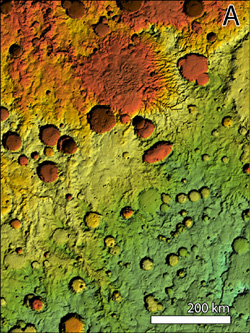
Valley Networks on Mars.  Credit:  NASA
Valley Networks on Mars. Credit: NASA

The researchers used a landform evolution model to simulate how the surface of Mars would evolve under different climate conditions. They ran more than 70 simulations under varied conditions and performed statistical analyses to determine which yielded the best match to the observed topography of martian valleys.

The results suggest that valley networks formed on Mars during a semiarid to arid climate that persisted for tens of thousands to hundreds of thousands of years. Episodic flooding alternated with long dry periods when water could evaporate or soak into the ground. Rainfall may have been seasonal, or wet intervals may have occurred over longer cycles. But conditions that allowed for the presence of liquid water on the surface of Mars must have lasted for at least 10,000 years, Barnhart said.

A paper describing their findings has been accepted for publication in the Journal of Geophysical Research–Planets.

Source: UC Santa Cruz

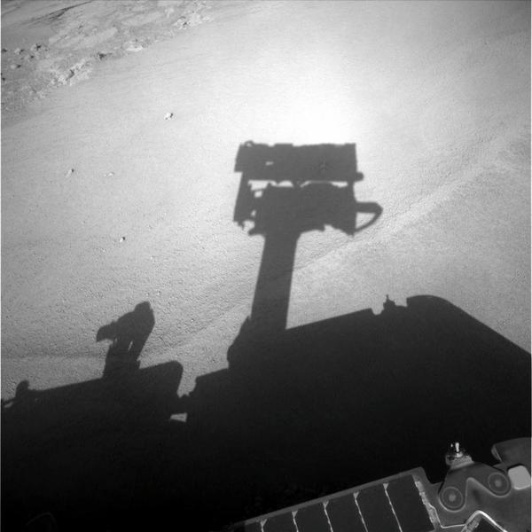
Opportunity Twitters Self Portrait

Opportunity self shadow portrait. Credit: NASA/JPL/Cornell

[/caption]

The Mars Exploration Rovers are now tweeting on Twitter, and Opportunity recently shared what she’s been doing since climbing out of Victoria crater via a shadow self portrait. After seeing a one-time electrical spike on Opportunity’s left front wheel, mission managers decided to have the rover climb out of the crater and get back on level ground. Opportunity is now examining some fist sized rocks, or cobbles, that might be ejecta from far away craters. Spirit, over on the other side of the Red Planet is weathering out the end of the southern hemisphere Martian winter. Another Twitter report from the rovers said that Spirit’s solar array energy is now up slightly from 235 to 245 watt hours. Power levels will have to rise a little more before Spirit can resume exploring actively.

Spirit's southern tilt.  Credit:  NASA/JPL/Cornell
Spirit's southern tilt. Credit: NASA/JPL/Cornell

Spirit has had to park on a north facing tilt in order to gather as much sunlight, and the image above shows the tilt. In the latest rover flight director video report, rover driver Scott Maxwell said the team is keeping an eye on the weather near Spirit’s, location watching for any rise in atmospheric dust. Dust has gathered on the rover’s solar panels, and any additional dust would hamper power levels as well. But so far everything is looking good, and Martian skies were actually clearer this past week.

Both rovers have been operating for more than 1,600 Martian sols, or days on Mars. A sol on Mars in about 40 minutes longer than an Earth day.

Phoenix Probe Says Both Yes and No to Water on Mars

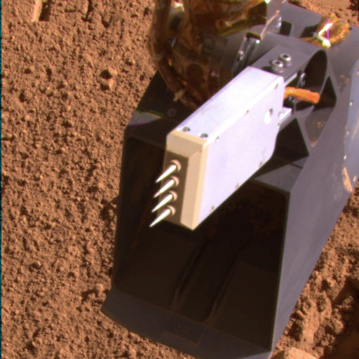
Phoenix's thermal and electroconductivity probe. Credit: NASA/JPL/Caltech/U of AZ

[/caption]

NASA’s Phoenix Mars Lander has a fork-like conductivity probe on it’s robotic arm, and results from the instrument are presenting a bit of a quandary for mission scientists. The thermal and electroconductivity probe has sensed humidity rising and falling in the air the near the lander, but when stuck into the ground, its measurements so far indicate soil that is thoroughly and perplexingly dry. “If you have water vapor in the air, every surface exposed to that air will have water molecules adhere to it that are somewhat mobile, even at temperatures well below freezing,” said Aaron Zent, lead scientist for the probe. While Phoenix has other tools to find clues about whether water ice at the site has melted in the past, the conductivity probe is the main tool for checking for present-day soil moisture.

Preliminary results from the latest insertion of the probe’s four needles into the ground, on Wednesday and Thursday, match results from the three similar insertions in the three months since landing. “All the measurements we’ve made so far are consistent with extremely dry soil,” Zent said. “There are no indications of thin films of moisture, and this is puzzling.”

In below-freezing permafrost terrains on Earth, that thin layer of unfrozen water molecules on soil particles can grow thick enough to support microbial life. One goal for building the conductivity probe and sending it to Mars has been to see whether the permafrost terrain of the Martian arctic has detectable thin films of unfrozen water on soil particles. By gauging how electricity moves through the soil from one prong to another, the probe can detect films of water barely more than one molecule thick.

Three other sets of observations by Phoenix, in addition to the terrestrial permafrost analogy, give reasons for expecting to find thin-film moisture in the soil.

One is the conductivity probe’s own measurements of relative humidity when the probe is held up in the air. “The relative humidity transitions from near zero to near 100 percent with every day-night cycle, which suggests there’s a lot of moisture moving in and out of the soil,” Zent said.

Another is Phoenix’s confirmation of a hard layer containing water-ice about 5 centimeters (2 inches) or so beneath the surface.

Also, handling the site’s soil with the scoop on Phoenix’s robotic arm and observing the disturbed soil show that it has clumping cohesiveness when first scooped up and that this cohesiveness decreases after the scooped soil sits exposed to air for a day or two. One possible explanation for those observations could be thin-film moisture in the ground.

The Phoenix team is laying plans for a variation on the experiment of inserting the conductivity probe into the soil. The four successful insertions so far have all been into an undisturbed soil surface. The planned variation is to scoop away some soil first, so the inserted needles will reach closer to the subsurface ice layer.

“There should be some amount of unfrozen water attached to the surface of soil particles above the ice,” Zent said. “It may be too little to detect, but we haven’t finished looking yet.”

Source: Phoenix News

Phoenix Lander Just Watchin’ the Clouds Go By

Clouds on Mars Movie by Phoenix. Image NASA/JPL-Caltech/University of Arizona/Texas A&M University

[/caption]

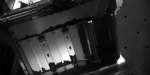
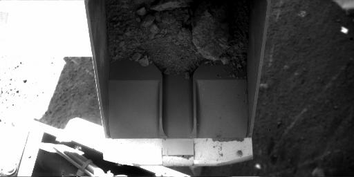
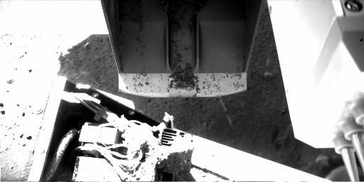
So, what do you do on a holiday? It’s Labor Day here in the U.S., and the Phoenix lander on Mars is just watching the clouds go by across the Martian sky. This movie clip consists of 10 frames taken over a 10 minutes period by the Surface Stereo Imager on the lander. The images were actually taken on Sol 94 (August 29 here on Earth) at 2:52 to 3:02 local time at the Phoenix landing site on Mars northern polar region. Scientists say particles of water-ice make up these clouds, like ice-crystal cirrus clouds on Earth. Ice hazes have been common at the Phoenix site in recent days. But, of course, Phoenix is still hard at work on Mars, and recent images downloaded from the lander show the doors have been opened on another tiny oven on the TEGA (Thermal and Evolved Gas Analyzer), oven #1, to bake another soil sample. Other images of the scoop on the robotic arm shows soil inside on one image, and on a subsequent image, it looks as though the scoop has dumped the sample, perhaps inside the oven, or it may have been a test scoop and dumped out on the ground.


The camera took the cloud images as part of a campaign by the Phoenix team to see clouds and track winds. The view is toward slightly west of due south, so the clouds are moving westward or west-northwestward.

The clouds are a dramatic visualization of the Martian water cycle. The water vapor comes off the north pole during the peak of summer. The northern-Mars summer has just passed its peak water-vapor abundance at the Phoenix site. The atmospheric water is available to form into clouds, fog and frost, such as the lander has been observing recently.

And here are the images from Sol 96 showing the open oven and the scoop with a sample of soil inside.

Oven door #1 has been opened.  Credit:  NASA/JPL/Caltech/U of AZ, Texas A&M
Oven door #1 has been opened.

Scoop with soil sample inside.  Credit:  NASA/JPL/Caltech/U of AZ

Scoop with soil inside, and then dumped.

Scoop looks as though its been dumped.  Credit:NASA/JPL/Caltech/U of AZ

Images are from Sol 96, or August 31, 2008.

Source: Phoenix News site and Gallery

Mars Rover On the Road Again (Gallery)

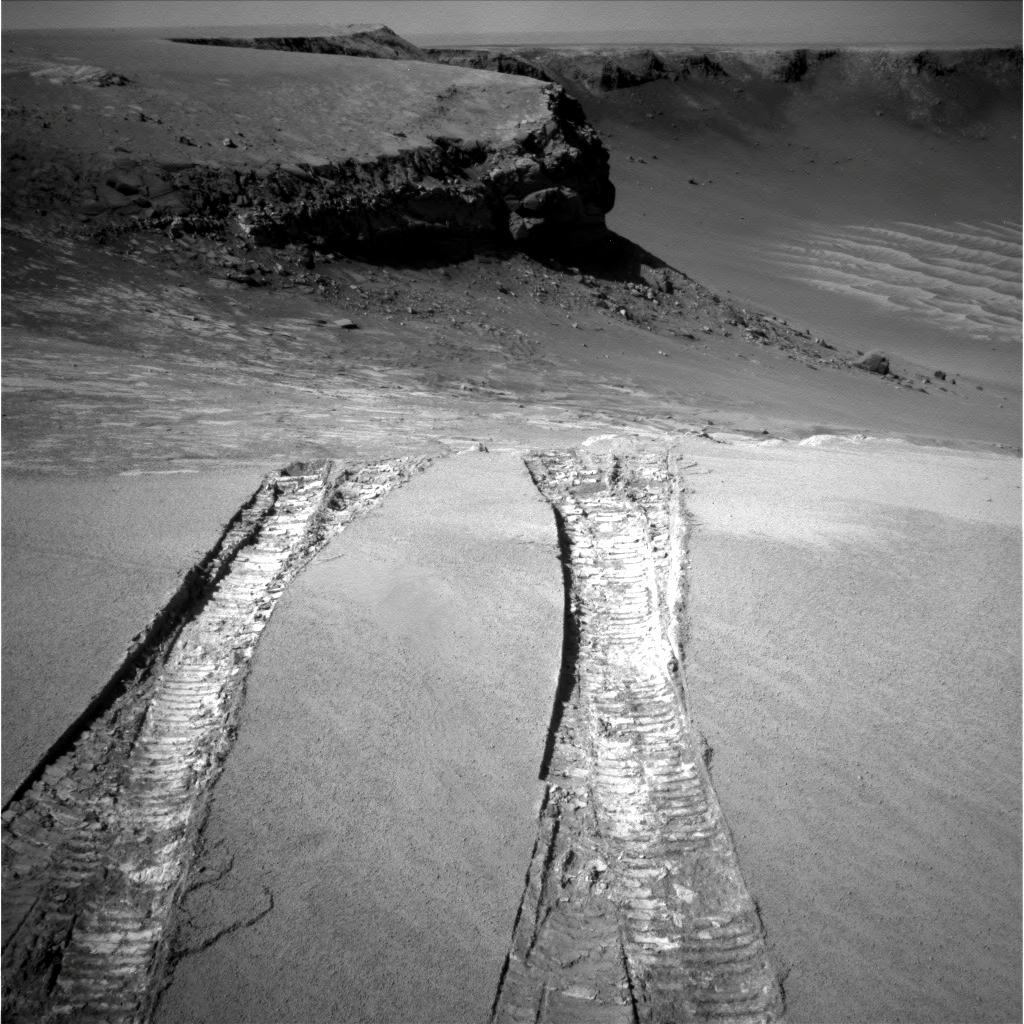
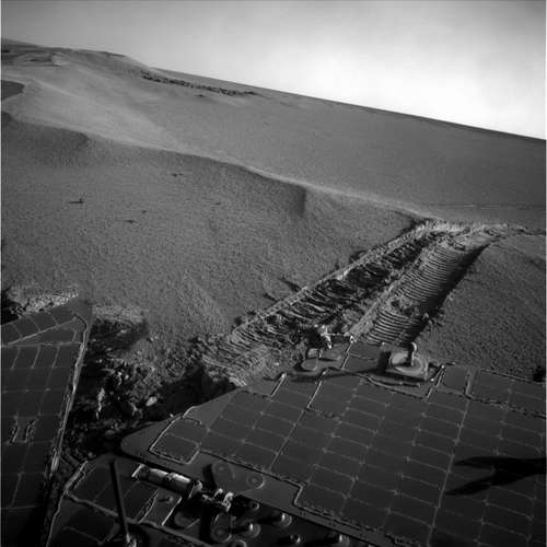
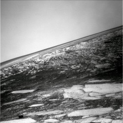
Opportunity looks back at it's climb from Victoria crater. Credit: NASA/JPL

[/caption]

NASA’s Mars Exploration Rover Opportunity has successfully climbed out of the Victoria Crater. “The rover is back on flat ground,” said an engineer who drives it, Paolo Bellutta of JPL. Opportunity used the same path to exit the crater and was used to enter the crater almost a year ago. “We’re headed to the next adventure out on the plains of Meridiani,” said JPL’s John Callas, project manager for Opportunity and its twin rover, Spirit. See more images from Opportunity’s climb….

Opportunity on the way out of Victoria.  Credit:  NASA/JPL
Opportunity on the way out of Victoria. Credit: NASA/JPL

Opportunity used its own entry tracks from nearly a year ago as the path for a drive of 6.8 meters (22 feet) bringing the rover out over the top of the inner slope and through a sand ripple at the lip of Victoria Crater. The exit drive, conducted late Thursday, completed a series of drives covering 50 meters (164 feet) since the rover team decided about a month ago that it had completed its scientific investigations inside the crater.

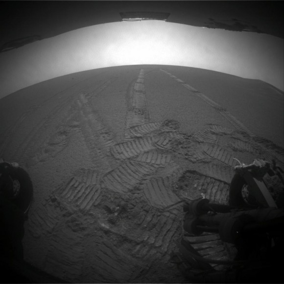
Rear hazcam view outside of crater.  Credit:  NASA/JPL
Rear hazcam view outside of crater. Credit: NASA/JPL

Here, Opportunity is back where she was almost a year ago before heading into the crater. Look closely and try to figure out which tracks are new and which are from a year ago!

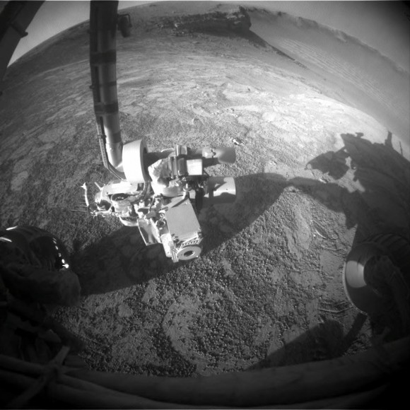
Robotic arm after exit.  Credit:  NASA/JPL
Robotic arm after exit. Credit: NASA/JPL

Opportunity stretches her robotic arm after leaving Victoria crater. See the crater in the background with the “Cape Verde” area (prominent ledge) visible. The crater spans about 800 meters (half a mile) in diameter and reveals rock layers that hold clues to environmental conditions of the area through an extended period when the rocks were formed and altered. The sun is behind this shot, creating shadows from the rover.

New rocks to explore.  Credit:  NASA/JPL
New rocks to explore. Credit: NASA/JPL

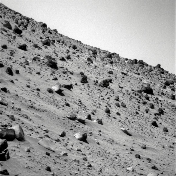
Now that Opportunity has finished exploring Victoria Crater and returned to the surrounding plain, the rover team plans to use tools on the robotic arm in coming months to examine an assortment of cobbles — rocks about fist-size and larger — that may have been thrown from impacts that dug craters too distant for Opportunity to reach.

Source: JPL Press Release,

A Chilly Sunrise on Mars

Sunrise on Mars. Credit: NASA/JPL/Caltech/U of AZ

Via Twitter, the Phoenix lander said, “I saw this beautiful sunrise yestersol. Bittersweet, as it means an end to midnight sun in the Martian arctic.” At Phoenix’s location above Mars arctic circle, the sun doesn’t set during the peak of summer in the northern hemisphere. If you recall, Phoenix took a montage of images of the non-setting sun last month.

But now, the period of maximum solar energy is past. On Sol 86, or the 86th Martian day after Phoenix landed, the sun set fully behind a slight rise to the north for about a half hour. This red-filter image taken by the lander’s Surface Stereo Imager, shows the sun rising on the morning of sol 90, Aug. 25, 2008, the last day of the Phoenix nominal mission.

Color poster from UnmannedSpaceflight.com

The image was taken at 51 minutes past midnight local solar time during the slow sunrise that followed a 75 minute “night.” The skylight in the image is light scattered off atmospheric dust particles and ice crystals.

The folks over at Unmanned Spaceflight created a color poster of the sunrise in honor of Phoenix’s 90th sol on Mars:

Download your very own large or medium size poster.

Phoenix will continue working for another month on Mars, through September 30. It seems there’s many people out there hoping for another short mission extension — for as long as the carbon dioxide ice stays away!

Source: Phoenix News

Hey, What Are Spirit and Opportunity Up to These Days?

Spirit's Bonestell Panorama. Image: NASA/JPL/Cornell

[/caption]

With the Phoenix lander busily working away on Mars and grabbing the recent headlines, we haven’t heard much from the other two robots on the Red Planet, the Mars Exploration Rovers, Spirit and Opportunity. Spirit has been hunkered down, trying to survive the harshest weeks of southern Martian winter. She’s waiting for the sun’s rays to get a little stronger before moving on, but has been taking images of her spot in the Home Plate area of Gusev Crater to create the panorama, shown here. Opportunity is now getting ready to head ’em up and move ’em out of Victoria Crater, where she’s been for nearly a year. So, what’s coming up for the two Energizer Bunny-like, long-lasting rovers?

“Both rovers show signs of aging, but they are both still capable of exciting exploration and scientific discovery,” said JPL’s John Callas, project manager for Spirit and Opportunity.

The team’s plan for future months is to drive Spirit south of Home Plate to an area where the rover last year found some bright, silica-rich soil. This could be possible evidence of effects of hot water.
Click here for an extra large version of Spirit’s panorama.

Opportunity will soon be on to new adventures.

“We’ve done everything we entered Victoria Crater to do and more,” said Bruce Banerdt, of NASA’s Jet Propulsion Laboratory in Pasadena, Calif. Banerdt is project scientist for the two rovers. Opportunity is heading back out to the Red Planet’s surrounding plains and check out some loose cobbles, or rocks that it drove by nearly a year ago before descending into the large Victoria crater to examine exposed ancient rock layers. But now that survey is complete.

Some of the cobbles that the rover will look at are approximately fist-size and larger. They were thrown long distances from impacts on Mars surface, and are interesting in that they might provide information about Mars’ subsurface varying areas.

Image from Opportunity's Pancam from Sol 1628.  Image: NASA/JPL/Cornell
Image from Opportunity's Pancam from Sol 1628. Image: NASA/JPL/Cornell

“Our experience tells us there’s lots of diversity among the cobbles,” said Scott McLennan of the State University of New York, Stony Brook. McLennan is a long-term planning leader for the rover science team. “We want to get a better characterization of them. A statistical sampling from examining more of them will be important for understanding the geology of the area.”

Opportunity entered Victoria Crater on Sept. 11, 2007, after a year of scouting from the rim. Once inside, the rover drove close to the base of a cliff called “Cape Verde,” part of the crater rim, to capture detailed images of a stack of layers 6 meters (20 feet) tall. The information Opportunity has returned about the layers in Victoria suggest the sediments were deposited by wind and then altered by groundwater.

“The patterns broadly resemble what we saw at the smaller craters Opportunity explored earlier,” McLennan said. “By looking deeper into the layering, we are looking farther back in time.” The crater stretches approximately 800 meters (half a mile) in diameter and is deeper than any other seen by Opportunity.

Engineers are programming Opportunity to climb out of the crater at the same place it entered. A spike in electric current drawn by the rover’s left front wheel last month quickly settled discussions about whether to keep trying to edge even closer to the base of Cape Verde on a steep slope. The spike resembled one seen on Spirit when that rover lost the use of its right front wheel in 2006. Opportunity’s six wheels are all still working after 10 times more use than they were designed to perform, but the team took the spike in current as a reminder that one could quit.

“If Opportunity were driving with only five wheels, like Spirit, it probably would never get out of Victoria Crater,” said JPL’s Bill Nelson, a rover mission manager. “We also know from experience with Spirit that if Opportunity were to lose the use of a wheel after it is out on the level ground, mobility should not be a problem.”

Opportunity now drives with its robotic arm out of the stowed position. A shoulder motor has degraded over the years to the point where the rover team chose not to risk having it stop working while the arm is stowed on a hook. If the motor were to stop working with the arm unstowed, the arm would remain usable.

Source: JPL Press Release

Big Brother is Watching Over the Red Planet

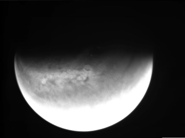
A view of the globe of Mars from orbit (ESA)

[/caption]
We have security cameras watching our daily habits, we watch voyeuristic TV shows of social misfits trapped in a house, we use webcams to transmit our musings on Youtube and we are constantly being monitored by hi-res satellite cameras. What can we possibly survey now? Surely every inch of the planet is under someone’s watchful eye? This planet maybe. By a stroke of luck, ESA scientists have just realised that a surplus camera on board the Mars Express orbiter could be switched back on and used as an interplanetary webcam. Big Brother is now keeping a watchful eye on the Red Planet too

Back in 2003, the Visual Monitoring Camera (VMC) had one task and one task only: keep a watchful eye over the UK’s Beagle 2 Mars lander as it separated from Mars Express and began its descent to the planet’s atmosphere. This fairly “normal” camera was only intended to verify that Beagle 2 had separated and begun on its correct trajectory. According to the only VMC/Beagle 2 image below, separation went as planned as we see the bright lander disk to the left of the image. The problems started later on for the lander as something happened to the robot on re-entry.

Bye bye Beagle 2 - The sole VMC image of the descending lander (ESA)

So, task complete, the VMC was switched off and forgotten about. After all, who needs a comparatively low-tech, glorified webcam orbiting Mars anyhow?

Hold on, an orbital webcam is actually pretty cool!

It would appear ESA scientists thought the same thing, pointing out that the VMC is “an ordinary camera in an extraordinary location.” For three years the VMC had been left dormant, until in 2007 the Mars Express Flight Control Team based at ESA’s European Space Operations Centre (ESOC) in Germany began testing the camera to see if it could be powered up again. The team couldn’t be sure if this little camera would even function as it was designed as a single-use instrument and it had been frozen in deep space for years.

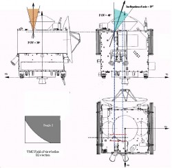
The location of the VMC on Mars Express with Beagle 2 attached (ESA)

But determined to make use of this instrument, the ESOC team were successful at bringing the VMC back online. For the last few months, scientists have been fine tuning the cameras optics to make it better at observing orbital features, and now this “ordinary” camera has been taking some “extraordinary” pictures. Geological features, Mars crescents and the Martian dynamic weather have been captured, making this a great little tool to see Mars from orbit.

Now, the VMC is online and taking pictures of Mars for us to see at home. What’s more ESA is inviting us to help with processing the raw images to come from the “Mars Webcam.”

For more information, see the ESA VMC page.

Please (Again)– Mars Will NOT Look As Big As the Full Moon

Mars. Credit: NASA

[/caption]

I thought this year would be different and finally I could make it through the month of August without receiving a forwarded email from an excited acquaintance, wondering if I knew about this incredible news that will happen only once in a lifetime. The email claims Mars is coming closer to Earth and will look as big as the full moon!

Please, this is a complete falsehood and entirely not true. The email about this “once in a lifetime event” has been circulating like clockwork every August for the past five years and is full of errors. If you don’t believe me, here are Universe Today articles dubunking this erroneous email in 2007, 2006, and 2005. If you don’t believe Fraser, Phil Plait the Bad Astronomer debunks the email here, here , here, and here’s the original one back in 2003. I don’t know if the general public really is so uneducated/gullible/in the dark to fall for this every year, or if the folks who start circulating this email every year are trying to determine how uneducated/gullible/in the dark the world actually is.

This began in August 2003 when Mars actually did make its closest approach to Earth in the past 60,000 years. On August 27th, 2003, Mars was 55,758,006 kilometers (34,646,418 miles) away from Earth. Mars just looked like a bright “star” in the sky, not much different than how it usually looks to the naked eye whenever the two planets are at their closest approach. The view of Mars in a telescope was a little better than usual back in 2003, as the bigger telescopes could see the ice caps a little clearer, and possibly some other features. Someone got some bad information as to how big Mars would look at this closest approach and got excited about this bad information, then sent said bad information out in an email which spread like wildfire through the wonders of email forwarding.

This year in August, Mars is about 360 million kilometers (about 215 million miles) from Earth, not very close at all. Since Mars and the Earth are in different orbits around the Sun, and they each take different amounts of time to go around the sun (Earth 365 days, Mars 687 Earth days) the distance between the two planets grows and shrinks, with the closest approaches occurring about every 26 months. But the distance changes with every approach because of the way celestial mechanics works.

If you still need more info, NASA has a page debunking this email, too. Please, let’s work hard to let everyone know this Mars email is completely wrong so that we don’t have to write this article again next year.

Phoenix Lander: The Digging Continues

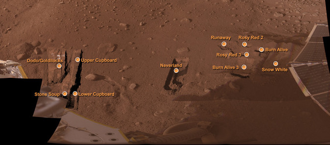
This mosaic of images shows the Phoenix worksite. Credit: NASA/JPL/Caltech/U of Arizona

[/caption]

Scientists and engineers from NASA’s Phoenix Mars Lander continue with digging operations around the lander with the spacecraft’s robotic arm. They are looking for new materials to analyze and are examining the soil and ice subsurface structure. “We expect to use the robotic arm heavily over the next several weeks, delivering samples to our instruments and examining trench floors and walls to continue to search for evidence of lateral and vertical variations in soil and ice structures,” said Ray Arvidson, Phoenix’s “dig czar,” from Washington University in St. Louis. New trenches opened recently and shown in the image here include the “Burn Alive 3” trench in the eastern portion of the arm’s reachable workspace.

The team is excavating one side of this trench down to the ice layer and plans to leave about 1 centimeter (0.4 inch) of soil above the ice on the other side. From this intermediate depth is where scientists hope to test a sample of soil in Phoenix’s Thermal and Evolved Gas Analyzer (TEGA).

Near the western end of the arm’s workspace, the team plans to dig as deep as possible in the “Cupboard” excavation area to study properties of the soil and ice in one of the polygon trough areas. Like on Earth, the polygon patterns form in areas of permafrost that goes through cycles of swelling and shrinking as the ground thaws and refreezes.

A sample from the Cupboard area may be delivered to the lander’s wet chemistry lab, part of the Microscopy, Electrochemistry and Conductivity Analyzer (MECA) to test for the presence of salts. In addition, the robotic arm will try to acquire ice-rich soil from “Upper Cupboard” and observe the material in the arm’s scoop to determine whether the sample sublimates. Melting is an indication of the presence of salt. If the sample melts and leaves behind a salty deposit, “Upper Cupboard” would be the location for the next sample for the wet chemistry lab. If no salts are detected, the team would
continue with plans to use the “Stone Soup” trench for acquiring the next wet chemistry lab sample.

If you’re wondering about the interesting names of the different areas, the team names the areas and trenches to make identification easier (instead of saying something like “that trench in the upper left corner of the image taken on Sol 45.”) The names are chosen from various fairy tales and myths.

A change has taken place for the scientists and engineers working with Phoenix. They are now working on Earth time instead of Mars time. This eliminates the constantly transitioning work period as a Mars sol is about 40 minutes longer than an Earth day. Undoubtedly, this has to make their lives much easier, instead of juggling their Earth life and Mars work every day.

Daily activities are being planned for the spacecraft as the lander performs activities that were sent up the previous day. Digging and documenting are done on alternate days to allow the science team time to analyze data and adjust activities accordingly.

In upcoming sols, the team plans to scrape the “Snow White” trench and experiment with acquiring and holding samples in the shade versus the sun. They want to find out if prolonged exposure to sunlight causes the acquired material to stick to the scoop, as has occurred with previous samples.

Source: Phoenix News site