Mars is Still Geologically Active

Shifting glaciers and exploding volcanoes aren?t confined to Mars? distant past, according two new reports in the journal Nature.

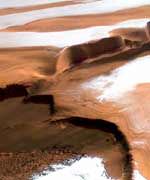
Glaciers moved from the poles to the tropics 350,000 to 4 million years ago, depositing massive amounts of ice at the base of mountains and volcanoes in the eastern Hellas region near the planet?s equator, based on a report by a team of scientists analyzing images from the Mars Express mission. Scientists also studied images of glacial remnants on the western side of Olympus Mons, the largest of the volcano calderas in the solar system. They found additional evidence of recent ice formation and movement on these tropical mountain glaciers, similar to ones on Mount Kilimanjaro in Africa.

In a second report, the international team reveals previously unknown traces of a major eruption of Hecates Tholus less than 350,000 million years ago. In a depression on the volcano, researchers found glacial deposits estimated to be 5 to 24 million years old.

James Head, professor of geological sciences at Brown University and an author on the Nature papers, said the glacial data suggests recent climate change in Mars? 4.6-billion-year history. The team also concludes that Mars is in an ?interglacial? period. As the planet tilts closer to the sun, ice deposited in lower latitudes will vaporize, changing the face of the Red Planet yet again.

Discovery of the explosive eruption of Hecates Tholus provides more evidence of recent Mars rumblings. In December, members of the same research team revealed that calderas on five major Mars volcanoes were repeatedly active as little as 2 million years ago. The volcanoes, scientists speculated, may even be active today.

?Mars is very dynamic,? said Head, lead author of one of the Nature reports. ?We see that the climate change and geological forces that drive evolution on Earth are happening there.?

Head is part of a 33-institution team analyzing images from Mars Express, launched in June 2003 by the European Space Agency. The High Resolution Stereo Camera, or HRSC, on board the orbiter is producing 3-D images of the planet?s surface.

These sharp, panoramic, full-color pictures provided fodder for a third Nature report. In it, the team offers evidence of a frozen body of water, about the size and depth of the North Sea, in southern Elysium.

A plethora of ice and active volcanoes could provide the water and heat needed to sustain basic life forms on Mars. Fresh data from Mars Express ? and the announcement that live bacteria were found in a 30,000-year-old chunk of Alaskan ice ? is fueling discussion about the possibility of past, even present, life on Mars. In a poll taken at a European Space Agency conference last month, 75 percent of scientists believe bacteria once existed on Mars and 25 percent believe it might still survive there.

Head recently traveled to Antarctica to study glaciers, including bacteria that can withstand the continent?s dry, cold conditions. The average temperature on Mars is estimated to be 67 degrees below freezing. Similar temperatures are clocked in Antarctica?s frigid interior.

?We?re now seeing geological characteristics on Mars that could be related to life,? Head said. ?But we?re a long way from knowing that life does indeed exist. The glacial deposits we studied would be accessible for sampling in future space missions. If we had ice to study, we would know a lot more about climate change on Mars and whether life is a possibility there.?

The European Space Agency, the German Aerospace Center and the Freie Universitaet in Berlin built and flew the HRSC and processed data from the camera. The National Aeronautics and Space Administration (NASA) supported Head?s work.

Original Source: Brown University

Problem with Opportunity’s Mineral Finding Tool

Image credit: NASA/JPL
NASA has suspended use of one of the mineral-identifying tools on the Opportunity Mars rover while experts troubleshoot a problem with getting data from the instrument, the robot’s miniature thermal emission spectrometer.

“As always, our first priority is to protect the instrument, so we have turned it off while we plan diagnostic tests,” said Jim Erickson of NASA’s Jet Propulsion Laboratory, Pasadena, Calif., project manager for the Mars Exploration Rover Project. “Opportunity’s other instruments are healthy and providing excellent science, and Spirit’s entire instrument suite is working well and being kept busy by the science team.”

Both Opportunity and Spirit, its twin, have been examining Mars since January 2004, more than four times as long as their successful three-month primary missions. While researchers work to diagnose the spectrometer-data problem and seek the best way to mend it or work around it, Opportunity is continuing its journey and observing a crater called “Vostok.” On the other side of the planet, meanwhile, martian winds have revealed themselves as dust devils in new images from Spirit and caused mixed effects on the rover itself, depositing dust on a camera and removing dust from solar panels.

On March 3 and 4, Opportunity transmitted data sets for 17 successful readings by its miniature thermal emission spectrometer but also reported that eight other attempted readings yielded incomplete data sets. This spectrometer, from high on the rover’s mast, observes rocks and other targets from afar. It measures the infrared radiation they emit in 167 different wavelengths, providing information about the targets’ composition. Two other types of spectrometers, mounted on the rover’s robotic arm, provide additional information about composition when the rover is close enough to touch the target.

Researchers are considering several possible root causes for the spectrometer-data problem. One possibility is malfunctioning of an optical switch that tells a mirror in the instrument when to begin moving. Another is that the mirror is not properly moving at a constant velocity. “If it is the optical switch, we could use a redundant one built into the instrument,” said Dr. Phil Christensen of Arizona State University, Tempe, lead scientist for the miniature thermal emission spectrometers on both rovers. He added that, if the root cause cannot be remedied, scientists could still get useful data from the instrument in its currently impaired condition.

Even a total loss of the miniature thermal emission spectrometer would not end the rover’s usefulness. In fact, NASA took a calculated risk by disabling this instrument on Opportunity 10 months ago, though the current problem appears unrelated to potential damage anticipated then. At that time, rover operators began using a “deep sleep” technique to conserve energy on Opportunity during reduced-sunshine months of Mars’ winter. Turning off power to overnight heaters let the instrument get cold enough to possibly damage its beam-splitter. However, the spectrometer kept working through the coldest months. Christensen said, “What we’re seeing now does not appear to be any problem with the beam-splitter.”

The rover team is not restricting use of Spirit’s miniature thermal emission spectrometer while troubleshooting the problem on Opportunity.

Spirit’s work capabilities grew with a sudden jump in output from solar panels on March 9, which caused the daily power supply to double. In a possibly related development three days earlier, some dust appeared to have blown onto lenses of Spirit’s front hazard-avoidance camera, enough for slight mottling in images from both the left and right eyes of the stereo camera, but not enough to affect the usefulness of the camera. Mottling in left-eye images cleared markedly the same day the power increased. Team members speculated that Spirit’s power boost, like similar ones on Opportunity in October, resulted from wind removing some accumulated dust from solar panels. Spirit captured pictures of dust-lofting whirlwinds on March 10, adding evidence for windy local conditions. Images the next day showed solar panels cleaned of most of their dust buildup.

Opportunity’s rear hazard-avoidance camera picked up some dust contamination three months ago. The dust on it has not affected operations and has neither decreased nor increased perceptibly since first noticed. No dust has contaminated lenses of the navigation cameras or panoramic cameras on either rover. From all cameras combined, the rovers have returned more than 72,000 images. Images and other geological data from Spirit and Opportunity are successfully providing unprecedented evidence about wet environmental conditions in Mars’ past.

JPL, a division of the California Institute of Technology in Pasadena, has managed NASA’s Mars Exploration Rover project since it began in 2000. Images and additional information about the rovers and their discoveries are available on the Internet at http://www.nasa.gov/vision/universe/solarsystem/mer_main.html and http://marsrovers.jpl.nasa.gov.

Original Source: NASA/JPL News Release

Rover Sees a Dust Devil on Mars

Mars is often enveloped by planet-wide dust storms – their biting winds choke the air and scour the arid surface. Tornado-like dust devils dance across the planet so frequently that their numerous tracks crisscross each other, tracing convoluted designs in the red soil. Martian dust includes magnetic, composite particles, with a mean size of one micron–the equivalent to powdered cement or flour in consistency. This size range is about five percent the width of a human hair.

By comparison to how a dust devil in Arizona might stir up uncultivated farmland, the scale on Mars is much more daunting. “These martian dust devils dwarf the five-to-10 meter terrestrial ones, can be greater than 500 meters in diameter and several thousand meters high. The track patterns are known to change from season to season, so these huge dust pipes must be a large factor in transporting dust and could be responsible for eroding landforms,” said Peter Smith of the University of Arizona (Tucson)

Mars has only a faint atmosphere [less than one percent of terrestrial pressures], yet offers up its history of dust devils as swirling tracks in a remarkable landscape of wind-swept and carved terrain. These tiny twisters tend to appear in the middle afternoon on Mars, when solar heating is maximum and when warm air rises and collides with other pressure fronts to cause circulation.

In his first press conference after the Spirit rover landed, the principal investigator for the rover’s science package, Cornell’s Steven Squyres, described one instance his team has been discussing: the intriguing possibility that at Gusev, over their mission, the rover’s camera may actually be able to animate a dust devil in action.

Squyres informally proposed a mini-series of frames, or twister movie which with some meterological luck, might offer a rare example of surface weather on another planet.

“At the Pathfinder site during its 83 sol mission, approximately thirty dust devils were either sensed by the pressure drop as they passed over the lander, or were imaged by the Pathfinder camera,” says Smith. “Based on these observations, one might expect to see several dust devils per hour from an active site on Mars between 10 am and 3 pm. Few, if any dust devils will be present at other times. Dust devils typically form during late spring and summer and can be found at all latitudes. Exactly, how their population density varies around the planet is currently unknown.”

In addition to Pathfinder’s run-in with a dust devil, previous missions to Mars have run into very dusty days. For instance, there was a dust storm covering the Viking Lander I (VL-1) site on Martian day (1742) or sol 1742 (1 Martian year=669 Earth days). In 1971, Mariner 9 and 2 USSR missions all arrived during a dust storm.

“Rovers and other robots must be carefully designed to withstand the sandblasting that they will endure from dust devils,” said Smith. “Bearing surfaces and solar panels must be protected and dust accumulation on solar panels will lower their efficiency.”

Actual mini-tornadoes of this magnetic dust, or dust devils, have been caught in the act by orbital cameras are highlighted by images below. These miniature tornadoes can span about 10 to 100 meters wide with 20- to 60-mile-per-hour (32- to 96-km/hr) winds swirling around a heated column of rising air. One might expect to see several dust devils per hour from an active site on Mars between 10 am and 3 pm, when rising afternoon air is hottest.

Original Source: Astrobiology Magazine

Opportunity Breaks Driving Records

On three consecutive days, NASA’s Mars Exploration Rover Opportunity accomplished unprecedented feats of martian motion, covering more total ground in that period than either Opportunity or its twin, Spirit, did in their first 70 days on Mars.

Spirit, meanwhile, has uncovered soil that is more than half salt, adding to the evidence for Mars’ wet past. The golf-cart-size robots successfully completed their three-month primary missions in April 2004 and are continuing extended mission operations.

Opportunity set a one-day distance record for martian driving, 177.5 meters (582 feet), on Feb. 19. That was the first day of a three-day plan transmitted to the rover as a combined set of weekend instructions. During the preceding week, engineers at NASA’s Jet Propulsion Laboratory had sent Opportunity and Spirit an upgrade of the rovers’ software, onboard intelligence the rovers use for carrying out day-to-day commands.

The new record exceeded a two-week old former best by 13 percent. As on all previous long drives by either rover, the traverse began with “blind” driving, in which the rover followed a route determined in advance by rover planners at JPL using stereo images. That portion lasted an hour and covered most of the day’s distance. Then Opportunity switched to “autonomous” driving for two and a half hours, pausing every 2 meters (6.6 feet) to look ahead for obstacles as it chose its own route ahead.

The next day, Opportunity used its new software to start another drive navigating for itself. “This is the first time either rover has picked up on a second day with continued autonomous driving,” said Dr. Mark Maimone, rover mobility software engineer at JPL. “It’s good to sit back and let the rover do the driving for us.”

Not only did Opportunity avoid obstacles for four hours of driving, it covered more ground than a football field. Opportunity has a favorable power situation, due to relatively clean solar panels and increasing minutes of daylight each day as spring approaches in Mars’ southern hemisphere. This allows several hours of operations daily.

On the third day of the three-day plan, the robotic geologist continued navigating itself and drove even farther, 109 meters (357 feet), pushing the three-day total to 390 meters (nearly a quarter mile). In one long weekend, Opportunity covered a distance equivalent to more than half of the 600 meters that had been part of each rover’s original mission-success criteria during their first three months on Mars.

Opportunity has now driven 3,014 meters (1.87 miles) since landing; Spirit even farther, 4,157 meters (2.58 miles). Opportunity is heading south toward a rugged landscape called “etched terrain,” where it might find exposures of deeper layers of bedrock than it has seen so far. Spirit is climbing “Husband Hill,” with a pause on a ridge overlooking a valley north of the summit to see whether any potential targets below warrant a side trip.

As Spirit struggled up the slope approaching the ridgeline, the rover’s wheels churned up soil that grabbed scientists’ attention. “This was an absolutely serendipitous discovery,” said Dr. Steve Squyres of Cornell University, Ithaca, N.Y., principal investigator for the rovers’ science instruments. “We said, ‘My gosh, that soil looks very bright. Before we go away, we should at least take a taste.”

The bright patch of disturbed soil, dubbed “Paso Robles,” has the highest salt concentration of any rock or soil ever examined on Mars. Combined information gained from inspecting it with Spirit’s three spectrometers and panoramic camera suggests its main ingredient is an iron sulfate salt with water molecules bound into the mineral. The soil patch is also rich in phosphorus, but not otherwise like a high-phosphorus rock, called “Wishstone,” that Spirit examined in December. “We’re still trying to work out what this means, but clearly, with this much salt around, water had a hand here,” Squyres said.

Meanwhile, scientists are re-calibrating data from both rovers’ alpha particle X-ray spectrometers. These instruments are used to assess targets’ elemental composition. The sensor heads for the two instruments were switched before launch. Therefore, data that Opportunity’s spectrometer has collected have been analyzed using calibration files for Spirit’s, and vice-versa. Fortunately, because the sensor heads are nearly identical, the effect on the elemental abundances determined by the instruments was very small. The scientists have taken this opportunity to go back and review the results for the mission so far and re-compute using correct calibration files. “The effect in all cases was less than the uncertainties in results, so none of our science conclusions are affected,” Squyres said.

JPL, a division of the California Institute of Technology in Pasadena, has managed NASA’s Mars Exploration Rover project since it began in 2000. Images and additional information about the rovers and their discoveries are available on the Internet at http://www.nasa.gov/vision/universe/solarsystem/mer_main.html and http://marsrovers.jpl.nasa.gov.

Original Source: NASA/JPL News Release

Mini-Detector Could Find Life on Mars or Anthrax at the Airport

Image credit: ESA
Dr. David Ermer, with his company, Opti-MS Corporation, is currently constructing a miniature Time of Flight Mass Spectrometer that can detect biological signatures at a very high resolution and sensitivity, but yet be small enough to be used for robotic and human applications in space exploration.

Ermer is using an innovative system that he developed at Mississippi State University, and he has received a NASA Small Business Innovation Research (SBIR) award to continue his research to build and test his device.

A mass spectrometer is used to measure molecular weight to determine the structure and elemental composition of a molecule. A high-resolution mass spectrometer can determine masses very precisely, and can be used to detect such things as DNA/RNA fragments, whole proteins and peptides, digested protein fragments, and other biological molecules.

A Time of Flight Mass Spectrometer (TOF-MS) works by measuring the time it takes for ions to travel through a vacuum area of the device known as the flight tube. Time of flight mass spectrometry is based on the fact that for a fixed kinetic energy, the mass and the velocity of the ions are interrelated. “Electric fields are used to give ions a known kinetic energy,” Ermer explained. “If you know the kinetic energy and know the distance the ions travel, and know how long it takes to travel, then you can determine the mass of the ions.”

Ermer’s device uses Matrix Assisted Laser Desorption Ionization, or MALDI, where a laser beam is directed at the sample to be analyzed, and the laser ionizes the molecules which then fly into the flight tube. The time of flight through the tube correlates directly to mass, with lighter molecules having a shorter time of flight than heavier ones.

The analyser and detector of the mass spectrometer are kept in a vacuum to let the ions travel from one end of the instrument to the other without any resistance from colliding with air molecules, which would alter the kinetic energy of the molecule.

A typical sample plate for a TOF-MS can hold between 100-200 samples, and the device can measure the complete mass distribution with one single shot. Therefore, huge amounts of data are created within a very short time interval, with the time of flight for most ions occurring in microseconds.

Ermer’s TOF-MS combines a relatively simple mechanical setup with extremely fast electronic data acquisition, along with the ability to measure very large masses, which is essential in doing biological analysis.

But the most unique aspect of Ermer’s device is its size. The commercial mass spectrometers that are currently available are at least one and a half meters long. That’s a fairly large volume to include on an in-situ scientific vehicle such as the golf car-sized Mars Exploration Rovers or even the larger Mars Science Laboratory Rover scheduled to launch in 2009. Ermer has devised a way to miniaturize a TOF-MS to an amazing 4? inches long. He estimates that his device will have a volume of less than 0.75 liters, a mass of less than 2 kilograms and require less than 5 watts of power.

Ermer used a non-linear optimization technique to create a computer model of a mass spectrometer. There were 13 parameters he input that had to be selected, including the spacing of the different elements in the TOF-MS and the ion acceleration voltages. Using this technique Ermer was able to find some unique solutions for a very short TOF-MS.

“I’m trying to build a Time of Flight Mass Spectrometer that is small enough to actually go in space,” Ermer said. “The main application that NASA is looking at is searching for biological molecules, to find evidence of past life on Mars. They also want to be able to do molecular biology on the space station, although the Mars application has a higher priority. My device should come in under all the requirements that NASA has, as far as the power, size, and weight requirements.”

Ermer also sees potential for his device to be used commercially as well. “What I have is a portable device to measure biological molecules,” he said. “If you were at an airport and found a white powder you’re going to want to know if it is anthrax or chalk dust fairly quickly. So you want a small, fairly cheap, portable device to be able to do that.” In his proposal to NASA, Ermer stated, “The main (commercial) application for miniature TOF-MS is the screening of infectious disease and biological agents. We also believe that the superior performance of our design will allow penetration into the general TOF-MS market.”

Ermer received the $70,000 SBIR award in mid-January, and has already built and tested a larger proof of concept design, which validates the technology that he designed for his TOF-MS. “So far, the tests have gone extremely well,” Ermer said. I have detected molecules up to 13,000 Daltons (Dalton is an alternate name for atomic mass unit, or amu.) The device is operating as designed for masses up to 13,000 Daltons and has mass resolution somewhat better than a full sized device at 13,000 Daltons. We are currently working on detecting mass out to 100,000 Daltons and initial results are promising.”

“Getting the device up and running is probably the biggest hurdle,” Ermer said about the challenges of this project. “A lot of the hard things are done, but the electronics are really difficult. For this device you have to generate high voltage pulses of about 16,000 volts. That was probably the hardest thing we’ve had to do so far.”

The electron multiplier detector is specially designed for miniature time of flight spectrometry by an outside company. Ermer and his own company designed most of the other parts of the device, including the vacuum housing and the laser extractor. Since it’s so small, creating these parts requires very high tolerance machining, which was also done by an outside company.

The NASA SBIR program “provides increased opportunities for small businesses to participate in research and development, to increase employment, and to improve U.S. competitiveness,” according to NASA. Some objectives of the program are to stimulate technological innovation, and to use small businesses to meet federal research and development needs. The program has three phases, with Phase I receiving $70,000 for six months of research to establish feasibility and technical merit. Projects making it to Phase II receive $600,000 for two more years of development, and Phase III provides commercialization of the product.

Ermer is a professor at Mississippi State University. He has been doing research in fields related to mass spectrometry since 1994, and for his PhD thesis at Washington State University, he looked at the energy distributions of ions that are generated in different materials by a laser. For his postdoctoral research at Vanderbilt, he studied the MALDI technique using an Infrared Free Electron Laser. More information about Opti-MS can be found at www.opti-ms.com.

Nancy Atkinson is a freelance writer and NASA Solar System Ambassador. She lives in Illinois.

Frozen Sea of Water Discovered on Mars

The discovery of a frozen sea close to the equator of Mars has brought the possibility of life on Mars one step closer. Open University scientist Dr John Murray is among the scientists who made the discovery from the High Resolution Stereo Camera images on board the Mars Express probe – the first European mission to another planet.

Dr Murray, of the Department of Earth Sciences, said: ?The fact that there have been warm and wet places beneath the surface of Mars since before life began on Earth, and that some are probably still there, means that there is a possibility that primitive micro-organisms survive on Mars today. This mission has changed many of my long-held opinions about Mars ? we now have to go there and check it out?.

The water that formed the sea appears to have originated beneath the surface of Mars, and to have erupted from a series of fractures known as the Cerberus Fossae, from where it flowed down in a catastrophic flood, and collected in a vast area 800 x 900 km about 5 million years ago. It initially averaged 45 metres deep, making it about the same size and depth as the North Sea. It was the pack-ice which formed on the surface of the sea that drew the attention of Mars Express scientists.

The young age of this feature has caused excitement among scientists. Although formed at the time when early hominids on Earth were evolving from apes, this is very young in geological terms, and suggests that vast flooding events, which are known to have occurred from beneath Mars? surface throughout its geological history, are still continuing to happen. The presence of liquid water for thousands of millions of years, even beneath the surface, is a possible habitat in which primitive life may have developed, and might still be surviving now. Clearly this must now be considered as a prime site for future missions looking for life.

The discovery was made by Dr Murray, Jan-Peter Muller (University College London), Gerhard Neukum (Free University, Berlin & Principal Investigator) and a team of international scientists working on the pictures sent back from Mars, and is to appear in the scientific journal Nature.

Mars Express, Europe?s first ever space mission to another planet, entered the orbit of Mars successfully on Christmas Day 2003, and since January 2004 the high resolution stereo camera on board has been taking a massive number of stereo images of the surface from altitudes as low as 270 km, showing details down to 10 metres.

Original Source: Open University News Release (Word Document)

Signs of Underground Life on Mars

NASA researchers believe they’ve found strong evidence that there could be underground life on Mars, huddled around pockets of liquid water. They haven’t found the life directly, but instead have discovered a unique methane signature that matches similar environments here on Earth, such as subsurface areas around Rio Tinto, a red-stained river in Spain. In order to get confirmation, NASA would need to send a spacecraft to Mars capable of drilling into the ground – unfortunately, none are planned currently.

Spirit Finds New Rock Affected by Water

NASA’s Spirit rover found a new class of water-affected rock, while its twin, Opportunity, finished inspecting its own heat shield and set a new martian driving record. The rovers successfully completed their three-month primary missions in April 2004 and are working on extended exploration missions.

“This is probably the most interesting and important rock Spirit has examined,” said Dr. Steve Squyres of Cornell University, Ithaca, N.Y., principal investigator for the rovers. The rock, dubbed “Peace,” is an exposure of bedrock in the Columbia Hills. The rock is in the Gusev Crater, where Spirit landed 13 months ago. “This may be what the bones of this mountain are really made of; it gives us even more compelling evidence for water playing a major role for altering the rocks here,? Squyres added.

Peace contains more sulfate salt than any other rock Spirit has examined. Dr. Ralf Gellert, of Max-Planck-Institut fur Chemie, Mainz, Germany, said, “Usually when we have seen high levels of sulfur in rocks at Gusev, it has been at the very surface. The unusual thing about this rock is that deep inside; the sulfur is still very high. The sulfur enrichment at the surface is correlated with the amount of magnesium, which points to magnesium sulfate.”

Observations by Spirit show the rock contains significant amounts of the minerals olivine, pyroxene and magnetite, all of which are common in some types of volcanic rock. The rock’s texture appears to be sand-size grains coated with a material loosely binding the rock together. Spirit’s rock abrasion tool dug about 1 centimeter (0.4 inch) deep in two hours.

“It looks as if you took volcanic rocks that were ground into little grains, and then formed a layered rock with them cemented together by a substantial quantity of magnesium-sulfate salt,” Squyres said. “Where did the salt come from? We have two working hypotheses we want to check by examining more rocks. It could come from liquid water with magnesium sulfate salt dissolved in it, percolating through the rock, then evaporating and leaving the salt behind. Or it could come from weathering by dilute sulfuric acid reacting with magnesium-rich minerals that were already in the rock. Either case involves water,” he said.

Opportunity used its microscopic imager last week to examine a cross section of the heat shield that protected the spacecraft as it slammed into Mars’ atmosphere. This is the first time experts have been able to examine a heat shield after it entered another planet’s atmosphere. Engineers expect the findings to aid design for future missions.

“We’ve identified each broken piece of the heat shield. We know there’s a lot of data there, but we still need to analyze it,” said Ethiraj Venkatapathy of NASA’s Ames Research Center, Moffett Field, Calif.

Christine Szalai, a spacecraft engineer at NASA’s Jet Propulsion Laboratory (JPL), Pasadena, Calif., said, “We are examining the images to determine the depth of charring in the heat shield material. In the initial look, we didn’t see any surprises. We will be working for the next few months to analyze the performance of the heat shield,” Szalai said.

Since leaving the heat shield, Opportunity has been traveling south to explore new sites. The rover set a single-day martian driving record, covering 154.65 meters (507.4 feet) on Jan. 28. Two days later, it drove even farther, 156.55 meters (513.6 feet). The first 90 meters (295 feet) of each drive was performed in blind-drive mode, following a route planners created from stereo images from the rover and maps created from orbital imagery. The rest was autonomous driving, with the rover choosing its own route to avoid any hazards it perceived in stereo images taken along the way.

“The terrain we’re crossing is so flat we can see a long way ahead,” said JPL rover planner Frank Hartman, who teamed with Jeff Biesiadecki to plot the drive. “Opportunity has paused for some trenching, but in a few days we’ll put the pedal to the metal again.”

For Images and additional information about the rovers on the Internet, visit:

http://www.nasa.gov/vision/universe/solarsystem/mer_main.html

For information about NASA and agency programs on the Internet, visit:

http://www.nasa.gov

Original Source: NASA News Release

Centre of Valles Marineris

This image, taken by the High Resolution Stereo Camera (HRSC) on board ESA?s Mars Express spacecraft, shows the central part of the 4000-kilometre long Valles Marineris canyon on Mars.

The HRSC obtained these images during during orbits 334 and 360 with a resolution of approximately 21 metres per pixel for the earlier orbit and 30 metres per pixel for the latter.

The scene shows an area of approximately 300 by 600 kilometres and was taken from an image mosaic that was created from the two orbit sequences. The image is located between 3? to 13? South, and 284? to 289? East.

Valles Marineris was named after the US Mariner 9 probe, the first spacecraft to image this enormous feature in 1971. Here, the huge canyon which runs east to west is at its widest in the north-south direction.

It remains unclear how this gigantic geological feature, unparalleled in the Solar System, was formed. Tensions in the upper crust of Mars possibly led to cracking of the highlands. Subsequently, blocks of the crust slid down between these tectonic fractures.

The fracturing of Valles Marineris could have occurred thousands of millions of years ago, when the Tharsis bulge (west of Valles Marineris) began to form as the result of volcanic activity and subsequently grew to the dimensions of greater than a thousand kilometres in diameter and more than ten kilometres high. On Earth, such a tectonic process is called ?rifting?, presently occurring on a smaller scale in the Kenya rift in eastern Africa.

The collapse of large parts of the highland is an alternative explanation. For instance, extensive amounts of water ice could have been stored beneath the surface and were then melted as a result of thermal activity, most likely the nearby volcanic Tharsis province.

The water could have travelled towards the northern lowlands, leaving cavities beneath the surface where the ice once existed. The roofs could no longer sustain the load of the overlying rocks, so the area collapsed.

Regardless of how Valles Marineris might have formed, it is clear that once the depressions were formed and the surface was topographically structured, heavy erosion then began shaping the landscape.

Two distinct landforms can be distinguished. On one hand, we see sheer cliffs with prominent edges and ridges. These are erosion features that are typical in arid mountain zones on Earth.

Today, the surface of Mars is bone dry, so wind and gravity are the dominant processes that shape the landscape (this might have been much different in the geological past of the planet when Valles Marineris possibly had flowing water or glaciers winding down its slopes).

In contrast, some gigantic ?hills? (indeed, between 1000 and 2000 metres high) located on the floors of the valleys have a smoother topography and a more sinuous outline. So far, scientists have no definitive explanation for why these different landforms exist.

Below the northern scarp, there are several landslides, where material was transported over a distance of up to 70 kilometres. Also seen in the image there are several structures suggesting flow of material in the past. Therefore, material could have been deposited in the valleys, making the present floor look heterogeneous.

In the centre of the image, there are surface features that appear similar to ice flows. These were previously identified in pictures from the US Viking probes of the 1970s; their origin remains a mystery.

Original Source: ESA News Release

ESA Will Risk Deploying MARSIS

The European Space Agency has given the green light for the MARSIS radar on board its Mars Express spacecraft to be deployed during the first week of May. Assuming that this operation is successful, the radar will finally start the search for subsurface water reservoirs and studies of the Martian ionosphere.

ESA’s decision to deploy MARSIS follows eight months of intensive computer simulations and technical investigations on both sides of the Atlantic. These were to assess possible harmful boom configurations during deployment and to determine any effects on the spacecraft and its scientific instruments.

The three radar booms of MARSIS were initially to have been deployed in April 2004, towards the end of the Mars Express instrument commissioning phase. They consist of a pair of 20-metre hollow cylinders, each 2.5 centimetres in diameter, and a 7-metre boom. No satisfactory ground test of deployment in flight conditions was possible, so that verification of the booms’ performance had to rely on computer simulation. Just prior to their scheduled release, improved computer simulations carried out by the manufacturer, Astro Aerospace (California), revealed the possibility of a whiplash effect before they locked in their final outstretched positions, so that they might hit the spacecraft.

Following advice from NASA?s Jet Propulsion Laboratory (JPL), which contributed the boom system to the Italian-led MARSIS radar instrument, and the Mars Express science team, ESA put an immediate hold on deployment until a complete understanding of the dynamics was obtained. JPL led a comprehensive investigation, including simulations, theoretical studies and tests on representative booms, the latter to assess potential aging of the boom material. European experts, from ESA and the former spacecraft prime contractor, Astrium SAS, France, worked closely with JPL throughout the entire investigation. An independent engineering review board, composed of ESA and industry experts, met in January to evaluate the findings and advise on ?if and when? to proceed with deployment.

The ESA review board, at its final meeting on 25 January, recommended deployment of the MARSIS booms. The rationale for the decision was based on the results of the analyses, which showed the possible impact scenarios, the amount of energy involved, the nature of the materials, and the physical conditions in space. The board concluded that the risk of an impact on the spacecraft could not be ruled out, but that the impact energy would be low and the probability of a severe failure was very small.

One credible failure case is that an antenna boom could become blocked during deployment, either by itself or by the spacecraft. Although means are available to unblock a deployment, in the worst case MARSIS would have to be considered partially or completely lost. However, the analyses have shown that the Mars Express control systems would be able to cope with such a configuration and minimise the consequences for the other scientific instruments.

The ESA board recommended planning the deployment for the week beginning 2 May. However, should the remaining preparations proceed faster than planned, it might be feasible to start deployment during the week beginning 25 April. An early deployment is scientifically desirable, as the evolution of the Mars Express orbit will allow radar measurements of the most interesting scientific regions on Mars to start in May 2005.

If, as expected, the deployment is successful, MARSIS will probe the secrets of Mars?s subsurface at least until 30 November 2005, the nominal end date of Mars Express operations, and beyond if the mission is further extended.

Original Source: ESA News Release