Close View of Phobos

This image, taken by the High Resolution Stereo Camera (HRSC) on board ESA?s Mars Express spacecraft, is Europe?s highest-resolution picture so far of the Martian moon Phobos.

This HRSC image shows new detail that will keep planetary scientists busy for years, working to unravel the mysteries of this moon. The image shows the Mars-facing side of the moon, taken from a distance of less than 200 kilometres with a resolution of about seven metres per pixel during orbit 756.

Images of Phobos as shown here had already been taken at lower resolution in previous orbits (413, 649, 682, 715 and 748). In the coming months, these first pictures will be followed by a series of images taken in subsequent fly-bys.

The Mars Express spacecraft periodically passes near Phobos about one hour before it flies at an altitude of only 270 kilometres above the Martian surface, just above the atmosphere. Within minutes, the orbiting spacecraft turns from its attitude where it points at Mars to train its camera on this little world.

The HRSC provided an unprecedented near-simultaneous group of 10 different images of the surface, enabling the moon’s shape, topography, colour, ?regolith? light-scattering properties, and rotational and orbital states to be determined. The regolith is the small-grained material covering most non-icy planetary bodies, resulting from multiple impacts on the body?s surface.

These images have surpassed all previous images from other missions in continuous coverage of the illuminated surface, not blurred and at the highest resolution. The US Viking Orbiter obtained a few small areas sampled at an even higher resolution of a few metres per pixel, but these were not so sharp due to the close and fast fly-by.

The global ?groove? network is seen in sufficient detail to cover the Mars-facing surface continuously from near the equator up to the north pole with regular spacing between the grooves. It now may be possible to determine whether the grooves existed before the large cratering events, and exist deep within Phobos, or came after the cratering events and were superimposed on them.

Much more detail is seen inside the various-sized craters, showing some with marked albedo variations. Some craters have dark materials near the crater floors, some have regolith that slid down the crater walls, and some have very dark ejecta, possibly some of the darkest material in our Solar System.

This tiny moon is thought to be in a ?death spiral?, slowly orbiting toward the surface of Mars. Here, Phobos was found to be about five kilometres ahead of its predicted orbital position. This could be an indication of an increased orbital speed associated with its secular acceleration, causing the moon to spiral in toward Mars.

Eventually Phobos could be torn apart by Martian gravity and become a short-lived ring around Mars, or even impact on the surface. This orbit will be studied in more detail over the lifetime of the Mars Express.

Original Source: European Space Agency

Rover Toolkits are Still Full

All the scientific tools on NASA’s two Mars Exploration Rovers are still working well, a full 10 months after Spirit’s dramatic landing.

The ones on Spirit are adding fresh evidence about the history of layered bedrock in a hill the rover is climbing.

“Our leading hypothesis is that these rocks originated as volcanic ash that fell from the air or moved in ground-hugging ash flows, and that minerals in them were altered by water,” said Dr. Ray Arvidson of Washington University, St. Louis, deputy principal investigator for the mission.

“This is still a working hypothesis, not a firm conclusion, but all the instruments have contributed clues that fit,” he said. “However, it is important to point out that we have just begun to characterize the textures, mineralogy and chemistry of these layered rocks. Other hypotheses for their origin focus on the role of transport and deposition by water. In fact, it may turn out that volcanism, water and wind have produced the rocks that Spirit is examining. We are just beginning to put together the big picture.”

Both rovers completed three-month primary missions in April. NASA has extended their missions twice because they have remained productive longer than anticipated.

“We’re still making good progress even though Spirit has two types of problems with its wheels,” said Jim Erickson, rover project manager at NASA’s Jet Propulsion Laboratory, Pasadena, Calif. “We are working around those problems successfully, but they might be a sign of things to come, as mechanical parts wear out during our exploration of Mars.”

One question for continuing investigations as Spirit heads for rocks higher in the “Columbia Hills,” is what the environment was like when water altered the minerals. Possibilities include water in the volcanic magma mixture before the ash erupted, surface water transporting the ash while it was still loose after the eruption, and ground water soaking through the rocks that solidified from the accumulated ash.

Some clues for a volcanic-ash origin come from a layered rock dubbed “Uchben.” Researchers pointed Spirit’s microscopic imager at a spot on Uchben scoured with the rock abrasion tool. The images reveal sand-size particles, many of them sharply angular in shape and some quite rounded. The angularity is consistent with transport by an eruption. Particles carried across the surface by wind or water usually tumble together and become more rounded. Uchben’s rounded particles may be volcanic clumps, may be concretions similar to what Opportunity has found, or may be particles tumbled in a water environment.

Evidence for alteration by water comes mainly from identification of minerals and elements in the rocks by the rover’s Moessbauer spectrometer and alpha particle X-ray spectrometer.

The rovers’ principal investigator, Dr. Steve Squyres of Cornell University, Ithaca, N.Y., said, “We have really made headway just in the last several weeks in understanding these rocks. The most likely origin is debris that blasted out of a volcano, was transported by air or water to its present location, and settled out in layers.”

Opportunity, meanwhile, examined a lumpy boulder called “Wopmay” inside “Endurance Crater.” The slope of the ground and loose surface material around the rock prevented Opportunity from getting firm enough footing to use its rock abrasion tool. Evidence from the spectrometers and microscopic imager is consistent with scientists’ earlier hypothesis that rocks near the bottom of the crater were affected by water both before and after the crater formed. The evidence is still not conclusive, Squyres said.

Opportunity is heading toward the base of “Burns Cliff,” a tall exposure of layered rock in the wall of the crater. However, if the rover encounters more of the poor traction found around Wopmay, planners may change course and drive up out of the crater.

JPL, a division of the California Institute of Technology in Pasadena, manages the Mars Exploration Rover project for NASA’s Science Mission Directorate, Washington. Images and additional information about the project are available from JPL at http://marsrovers.jpl.nasa.gov and from Cornell University at http://athena.cornell.edu.

Original Source: NASA/JPL News Release

Tithonium Chasma on Mars

This image, taken by the High Resolution Stereo Camera (HRSC) on board ESA?s Mars Express spacecraft, shows the western end of the Valles Marineris Canyon system on Mars.

The image was taken during orbit 442 with a ground resolution of approximately 52 metres per pixel. The displayed region is located at the beginning of the canyon system at about latitude 7? South and longitude 269? East.

The image shows the western end of the canyons Tithonium Chasma and Ius Chasma, part of the Valles Marineris canyon system, which are up to 5.5 kilometres deep.

The whole canyon system itself is the result of a variety of geological processes. Probably tectonic rifting, water and wind action, volcanism and glacial activity all have played major roles in its formation and evolution.

The canyon floors are covered by a dark, layered material, the so-called ?Interior Layered Deposits?. These deposits are marked by a system of polygonal cracks through which the underlying, lighter-coloured rock can be seen.

The Interior Layered Deposits are still a major topic of research. Parts of the deposits are most probably volcanic, while in other areas a sedimentary origin has been proposed.

The morphology of the valley flanks has been modified by ?slumping? and rockfalls. Slumping is when a substantial part of a mountain, cliff or hill ?breaks away? and slides more or less intact to the bottom of the slope.

Some of the major slumps here are more than thirty kilometres wide. The flanks are often covered to a large extent by their own ?talus?, or rock debris that has fallen from the sides of a cliff or steep slope.

The large, deeply eroded Crater Oudemans in the south of the area (bottom of the image) has a diameter of about 120 kilometres.

Around the central mount of the crater, large plains composed of dark rock can be seen. These plains are covered by lighter sediments, deposited through the action of the wind. Several systems of tectonic faults can be seen in the imaged area.

The most prominent is the system of Valles Marineris itself, running east-west. South of Crater Oudemans, smaller tectonic ?grabens? running from the south-west to the north-east can be seen. To the north of the large canyons, there are more fault systems.

The Valles Marineris region is one of the most studied areas on Mars. The canyon system is one of the major keys to the tectonic and volcanic history of this planet. Research on the sedimentary rocks and the products of erosion can also provide major insights into its climatic evolution.

Due to the stereo capability of the HRSC, the new image data gained can provide new insights into the geology of Mars. This will lead to a new, more precise reconstruction of Martian geological history.

Original Source: ESA News Release

Beagle 2 Just Didn’t Have the Money to Succeed

This inquiry focussed upon the way in which the UK Government supported the Beagle 2 consortium in the development of a lander for the European Space Agency’s (ESA) Mars Express mission and the implications of the project for future Government space policy.

We found that the Government was admirably enthusiastic about this exciting but high risk project. However, it was unable to respond to its relatively sudden emergence to find the guaranteed financial backing that was needed to support the development of a lander against extremely tight time and mass constraints. As a result of this, and the failure of sponsorship income to materialise, the project could not proceed to its development and testing phases as early as it should, with a consequent detrimental impact on its chances of success. We have called for improvements in the Government’s capacity to respond to major financial commitments at short notice.

The decision for the lander to be developed separately from the orbiter has been acknowledged to be wrong. It reduced the scope for flexible and co-ordinated management of the mission. It also contributed to tensions in the relationship between the Beagle 2 consortium, ESA and other contractors, which increased as technical difficulties with the lander created doubts in some quarters at ESA about the viability of the lander. The decision was in line with existing ESA policy. It was also reinforced by a desire on the UK side for the lander to be distinctively British and a reluctance by ESA Member States to take any financial responsibility for a UK-led project. These concerns must be overcome in future, ESA-managed, missions.

We found that oversight of the Beagle 2 project, both by ESA and the UK Government, was lacking. When the project ran into difficulties, both sides belatedly intervened to introduce more certainty to the financial and management arrangements, but failed to ensure that the most important weaknesses in the mission were adequately addressed.

The Beagle 2 project had wider goals than the search for life on Mars. Technologies developed by UK teams have potential uses in other fields, such as medicine. We welcome the emphasis the Government has given to the science in society and educational objectives behind its support for the project, which helped justify the financial commitment made. The Beagle 2 project also placed the UK in a strong position to contribute to future ESA space exploration missions. These benefits should not be wasted. In this context, we welcome the Particle Physics and Astronomy Research Council’s (PPARC) decision to fund early UK participation in ESA’s Aurora space exploration programme. Long term participation will be expensive however. In view of the benefits accruing to the wider scientific community and UK science more generally, we have recommended that the Government does not leave it to PPARC alone to fund future UK involvement.

Original Source: Beagle 2 Failure Report

Rovers Have Returned 50,000 Pictures

Image credit: NASA/JPL
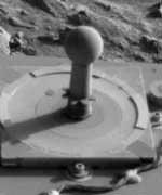
A view of the sundial-like calibration target on NASA’s Mars Exploration Rover Spirit, with a bit of martian terrain in the background, is the 50,000th image from the twin rovers that have been exploring Mars since January.

The images stock a treasury of scientific information on scales from microscopic detail to features on the horizon scores of kilometers or miles away, and even include glimpses of Mars’ moons, Earth and the Sun. They also provide an always-current understanding of the surrounding terrain for use by the team of rover wranglers planning each day’s activities on Mars.

There are now more than twice as many images from the two rovers as from NASA’s three previous Mars surface missions combined: Viking Lander 1, Viking Lander 2 and Mars Pathfinder. “The cameras on Spirit and Opportunity have been reliable, sharp eyes for our adventure of exploring some amazing places on Mars,” said Dr. Justin Maki of NASA’s Jet Propulsion Laboratory, Pasadena, Calif., an imaging scientist on the rover team. “The pictures continue to be stunning. One big difference from earlier Mars surface missions is that the rovers continue to show us new places and new sights.”

All raw images that reach Earth from the rovers are posted online at http://marsrovers.jpl.nasa.gov/gallery/all. Captioned pictures, including the 50,000th image and panoramas assembled from many individual raw images, are posted at http://marsrovers.jpl.nasa.gov/gallery/press/.

Both rovers have successfully completed their three-month primary missions and their first mission extensions. They began second extensions of their missions on Oct. 1.

Counting stereo instruments as separate right and left cameras, each rover carries nine cameras.

The stereo panoramic cameras have taken most of the images. Spirit’s accounts for 35 percent of the all images from the rovers so far; Opportunity’s, 32 percent. Color pictures from these cameras combine individual frames taken through different filters. Mosaic image products stitch together many contiguous frames for a larger view. A single 360-degree color panorama uses more than 100 individual images. Usually when a panoramic camera is used, it takes a series of shots of the calibration target through different filters to aid in accurate interpretation of the other shots it takes. It is no surprise that Spirit’s calibration target happened to be the subject in the 50,000th image, since it has become the single most photographed subject on Mars.

Spirit’s front hazard-avoidance camera (also two cameras for stereo views) has the next highest fraction of the rovers’ image catalog at 9 percent. That signifies the importance of this low-slung camera in Spirit racking up 3.6 kilometers (2.3 miles) of driving so far. Opportunity has driven 1.6 kilometers (1 mile) and its front hazard-avoidance camera has taken 3 percent of all rover images. Totals for the rear hazard- avoidance cameras are about one-fifth of the number from the front cameras on each rover.

Each rover’s stereo navigation camera sits up on the mast with the panoramic camera but takes wider-angle images without filters. Spirit’s navigation camera has taken 7 percent, and Opportunity’s 6 percent, of all rover images.

Some days when Spirit was driving long distances, Opportunity was busy examining bedrock exposures and soil patches with its microscopic imager. That camera on Opportunity has taken 4 percent of all rover images; the one on Spirit, 2 percent. Each spacecraft had a 10th camera on the bottom of its lander, which contained the rover during the descent through Mars’ atmosphere. Those descent cameras each took three images, as planned, during the final minute before impact.

NASA’s Viking Lander 1 returned 3,542 images while it operated for 79 months beginning in 1976. Viking Lander 2 returned 3,043 images while it operated for 43 months, also beginning in 1976. Mars Pathfinder returned 16,635 images from its lander and 628 from its Sojourner rover during 12 weeks of operation in 1997.

JPL, a division of the California Institute of Technology in Pasadena, manages the Mars Exploration Rover project for NASA. Images and additional information about the project are available from JPL at http://marsrovers.jpl.nasa.gov and from Cornell University at http://athena.cornell.edu.

Original Source: NASA/JPL News Release

More Findings About Methane on Mars

A University of Michigan scientist is part of a European Space Agency team that has detected methane gas on Mars, and the findings will be published in the online Web journal Science Express today.

Sushil Atreya, professor and director of the Planetary Science Laboratory in the College of Engineering says the detection of methane is the clearest indicator of the possibility of life on the Red Planet yet.

“Biologically produced methane is one of many possibilities,” Atreya said. “Methane is a potential biomarker, if a planet has methane we begin to think of the possibility of life on the planet. On Earth, methane is almost entirely derived from biological sources.”

Mars resembles Earth more than any other planet in our solar system, and studying its atmosphere gives us a greater understanding of our own.

How the methane got to Mars is the big question, and there are several possible sources, Atreya said. The most exciting scenario is that methanogens?microbes that consume the Martian hydrogen or carbon monoxide for energy and exhale methane?dwell in colonies out of sight beneath the surface of the red planet.

“These are anaerobic so they don’t need oxygen to survive, if they are there,” Atreya said. “If they are there, they would be underground.”

Speculation is tempting, but many more experiments are necessary before drawing any conclusions.

“While it’s tantalizing to think there are living things on Mars, we aren’t in a position to say that is what is causing the methane,” Atreya said.

A comet could have struck the planet, which would leave methane behind, but that only happens once every 60 million years or so, Atreya said. A more likely scenario is hydrothermal process involving chemical interaction between rock and water in aquifers below the Martian permafrost.

The instrument that sniffed out the methane is called a planetary Fourier spectrometer, and it is one of seven instruments on board the Mars Express spacecraft. The spectrometer measures the Sun’s infrared light that has been absorbed, emitted and scattered by the molecules in the Martian atmosphere. Every molecule has a unique spectral property?think of it as an infrared fingerprint?including methane.

The spectrometer detected an average 10 parts per billion by volume (ppbv) of methane on Mars, a small amount compared to the approximately 1700 ppbv on Earth. The methane gas was distributed unevenly over Mars’ surface, which tends to support the theory that an internal, on-site source, rather than a comet, is the source generating the methane, said Atreya.

Mars Express launched in June 2003, and it is the first Western European trip to another planet.

Original Source: University of Michigan News Release

Spirit Steering Problem Returns

A problem that affects the steering on NASA’s Mars Exploration Rover Spirit has recurred after disappearing for nearly two weeks.

Engineers at NASA’s Jet Propulsion Laboratory, Pasadena, Calif., are working to fully understand the intermittent problem and then implement operational work-arounds. Meanwhile, Spirit successfully steered and drove 3.67 meters (12 feet) on Oct. 17.

Rover engineers are also analyzing a positive development on Spirit’s twin, Opportunity: a sustained boost in power generation by Opportunity’s solar panels.

Both rovers have successfully completed their three-month primary missions and their first mission extensions. They began second extensions of their missions on Oct. 1.

Rover engineers refrained from driving Spirit for five days after an Oct. 1 malfunction of a system that prevents wheels from being jostled in unwanted directions while driving. Each of the front and rear wheels of the rover has a motor called a steering actuator. It sets the direction in which the wheel is headed. The steering actuators are different from the motors that make the wheels roll, and hold the wheel in a specific direction while driving. A relay used in turning these steering actuators on and off is the likely cause of the intermittent nature of the anomaly.

The relay operates Spirit’s right-front and left-rear wheels concurrently, and did not operate as commanded on Oct. 1. Subsequent testing showed no trace of the problem, and on Oct. 7, the rover steered successfully and drove about 2 meters (7 feet), putting it in position to examine a layered rock called “Tetl” for several days. However, the anomaly occurred again on Oct. 13, and the problem appeared intermittently in tests later last week.

“We are continuing tests on Spirit and in our testbed here at JPL,” said Jim Erickson, Mars Exploration Rover project manager at JPL. One possible work-around would be to deliberately blow a fuse controlling the relay, disabling the brake action of the steering actuators. The rovers could be operated without that feature. “The only change might be driving in shorter steps when the rover is in rugged terrain,” Erickson said.

Spirit has driven a total of 3,647 meters (2.27 miles) since landing, more than six times the distance set as a goal for the mission. Its current target is a layered rock called “Uchben” in the “Columbia Hills.” Opportunity has driven 1,619 meters (just over a mile). Its latest stop is a lumpy boulder dubbed “Wopmay” inside “Endurance Crater.”

The daily power supply for each rover comes from 1.3 square meters (14 square feet) of solar panels converting sunlight into electricity. Just after the landings in January, the output was about 900 watt-hours per day for each rover — enough to run a 100-watt bulb for nine hours. As anticipated, output gradually declined due to dust buildup and the martian seasonal change with fewer hours of sunlight and a lower angle of the Sun in the sky. By July, Spirit’s daily output had declined to about 400 watt-hours per day. It has been between 400 and 500 watt-hours per day for most of the past two months.

Opportunity, closer to Mars’ equator and with the advantage of a sunward-facing tilt as it explored inside the southern half of a crater, maintained an output level between 500 and 600 watt-hours per day in June, July and August. Since early September, the amount of electricity from Opportunity’s solar panels has increased markedly and unexpectedly, to more than 700 watt-hours per day, a level not seen since the first 10 weeks of the mission.

“We’ve been surprised but pleased to see this increase,” said Erickson, “The team is evaluating ways to determine which of a few different theories is the best explanation.”

Possible explanations under consideration include the action of wind removing some dust from the solar panels or the action of frost causing dust to clump. “We seem to have had several substantial cleanings of the solar panels,” Erickson said.

JPL, a division of the California Institute of Technology in Pasadena, manages the Mars Exploration Rover project for NASA’s Science Mission Directorate, Washington. Additional information about the project is available from JPL at http://marsrovers.jpl.nasa.gov/ and from Cornell University, Ithaca, N.Y., at http://athena.cornell.edu.

Original Source: NASA/JPL News Release

Gmail Invites

I made a mention in yesterday’s newsletter that I had a few Gmail invites left over. You know, this is Google’s competitor to Hotmail and Yahoo that gives you a free email address with one GB of space. It’s still in beta, but I’m really impressed with it so far. I made a small mention down at the bottom, but I was still deluged with email requests for a Gmail invite. I had posted 6 invites in the Universe Today forum, and they were snapped up in a few minutes.

Now, I know there are hundreds of you reading this newsletter with some Gmail invites to spare, so I was wondering if you could help out. Visit the forum, head down to the bottom and post any spare invite links that you have. I’ve posted instructions in the forum on how to do this. Do not email me directly asking for an invite.

Here’s a link to the thread in the forum where everyone is posting their invites. Please help out if you can.

Thanks!

Fraser Cain
Publisher
Universe Today

P.S. The Universe Today forum has nearly 3,000 members now from all around the world. Come, hang out, and chat with other space enthusiasts!

Edge of Huygens Crater

This image, taken by the High Resolution Stereo Camera (HRSC) on board ESA?s Mars Express spacecraft, shows the eastern rim of the Martian impact crater Huygens.

The image was taken during orbit 532 in June 2004 with a ground resolution of approximately 70 metres per pixel. The displayed region is centred around longitude 61? East and latitude 14? South.

Huygens is an impact structure, about 450 kilometres wide, located in the heavily cratered southern highlands of Mars. Crater counts of the rim unit of the impact basin indicate that it is almost 4000 million years old.

This implies that this basin was formed in the early history of the planet and indicates a period of heavy bombardment in roughly the first 500 million years of the planet?s lifetime.

The basin shows an inner ring that has been subsequently filled by sediments transported into the crater.

Thia image showa part of the eastern rim of the crater. The rim is heavily eroded and shows a ?dendritic? pattern. This observation suggests surface water run-off.

Dendritic systems are the most common form of drainage system found on Earth. They consist of a main ?river? valley with tributaries with their own tributaries. From above, they look like a tree or a river delta in reverse.

The valley system is blanketed by dark material, which was either transported by a fluid running through the channels or by wind-driven (?aeolian?) processes. Part of the area has been covered by slightly redder material, which implies a different chemical composition.

Original Source: ESA News Release

Dust Obscured Martian Landscape

This image, taken by the High Resolution Stereo Camera (HRSC) on board ESA?s Mars Express spacecraft, shows a part of the southern highlands of Mars, called Promethei Terra.

The image was taken during orbit 368 in May 2004 with a ground resolution of approximately 14 metres per pixel. The displayed region is centred around longitude 118? East and latitude 42? South.

It shows an area in the Promethei Terra region, east of the Hellas Planitia impact basin. The smooth surface is caused by a layer of dust or volcanic ash that is up to several tens of metres thick.

This layer has covered all landforms, and even young impact craters have lost their contours due to in-fill and collapse of their fragile crater walls. This layer has been removed by the wind at some ridges and crater walls.

Although the image was taken at high resolution and show very fine detail, this covering layer leads to a slightly fuzzy appearance.

The large impact crater in the southern part of the image is 32 kilometres wide and up to 1200 metres deep. The dark crater floor is most likely the result of ?deflation?, the geological term for the lifting and removal of loose material.

The dust removed here has accumulated in the southern part of the crater, forming a thick layer. The numerous dark tracks to the north-western and west are ?dust devil? tracks.

These atmospheric ?eddies?, like tornadoes on Earth, remove the uppermost dust layers which have a slightly different colour to the now-exposed surface. The tracks can be more than 20 kilometres long and contrast prominently with the lighter-coloured surroundings.

Dust devil tracks provide short-lived evidence of the ongoing geological and atmospheric activity on Mars, which consists mainly of the transport of dust by wind.

Another sign for this ?aeolian? (wind-related) activity in the area is the existence of small dune fields that have formed in some of the depressions. They can be seen in the crater in the north and in its surroundings (see close-up).

The dust devils are not limited by geomorphological boundaries: for example, their tracks cross the crater rim. Dust devil tracks can also be seen on the thick dust layer in the southern part of the crater.

Due to the thickness of the dust layer, no darker material is exposed here. The dust devil tracks show two distinct directions of movement: east to west and south-east to north-west.

Original Source: ESA News Release