Opportunity Finds Polished Spheres in its Trench

Image credit: NASA/JPL
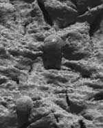
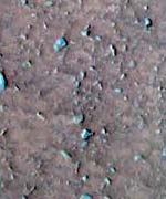
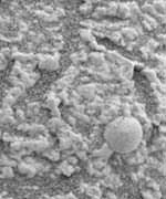
Because the rover Opportunity found spherical granules around its landing site on Mars, researchers put it to work digging a trench to see if they were also beneath the surface. Microscopic imager pictures now show that the granules, millimeters in size and dubbed “blueberries,” also are embedded in the walls of the trench.

And the images show the blueberries are polished and shiny. “We’re not sure what is going on here, but there is some process happening at the subsurface, said Mars rover science team member Albert Yen at a press conference at the Jet Propulsion Laboratory (JPL) in Pasadena today (Feb. 19).

Science team leader Steven Squyres, Cornell professor of astronomy, told the press briefing that he expects the spherical granules to be common over most of the Martian surface. But, he said, “We don’t know what their pedigree is.”

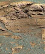
To find out, Opportunity is about to embark on a trip to what he called “a blueberry patch,” a “wonderful finely layered laminated bedrock” dubbed El Capitan, where it’s known there are many of the granules. The exposed bedrock has a gently sloping lower portion and a much steeper upper portion, overhanging in places. The aim is, Squyres said, to “zero in on a place where there are lots of those spherical granules and look in detail with the microscopic imager.” The rover is exploring a crater in an area of Mars called Meridiani Planum.

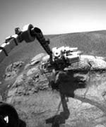
The intention also is to grind away the rocks’ outer layers with the rover’s rock abrasion tool and put the rover’s alpha-praticle X-ray spectrometer (APXS) up against the rock to see if it is sulfur rich all the way through. The rover’s M?ssbauer spectrometer also will be used to see what minerals are present.

There are, said Squyres, basically three questions that Opportunity is trying to answer. First, how were these materials deposited — by air or by water? Second, where did the blueberries embedded in the outrcop come from — were they dropped in from above, or did they grow in place? Third, what is the composition of the outcrop and “What does it tell us or not tell us about the possibility that water was involved in forming the minerals that are in this outcrop?”

The yellow line shows Spirit’s path so far. Click on the image for a high-resolution version (889 x 723 pixels, 360K)
Yen also noted that microscopic imaging of sand-size grains in the trench show they were cemented together. He referred to a theory going back to the Viking mission that water vapor exchanged between the Martian atmosphere and the subsurface could mobilize salts in the upper few centimeters of the surface, depositing a weak cement that could hold granules together. “We are looking for evidence of any salt products that might hold the grains together,” he said.

Possible evidence of salts also was mentioned by Dave Des Marais, a science team member from NASA-Ames Laboratory, in describing the latest data from Opportunity’s twin, Spirit, in Gusev crater on the opposite side of Mars. Spirit has been investigating Laguna Hollow, a depression containing fine grain material. After the rover wiggled its right front wheel and backed up and turned, it was found that some of the material was sticking to the wheel. Des Marais suggested that the stickiness might result from salt or brine. The plan is, he said, to dig a trench and look for evidence of brine moving up to the surface, evaporating and depositing salt at the surface.

Both rovers, it seems, have an abundance of time to carry out their investigations. Squyres noted that both vehicles’ power and thermals systems “are holding up spectacularly well.” And although the mission originally was expected to last about 90 Martian days, or sols, “I will say that I have talked to people at my apartment complex about staying through the summer,” he said.

Original Source: Cornell News Release

Mars Express Image of Kasei Vallis

Image credit: ESA
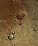
This vertical view shows the mouth of Kasei Vallis, one of the largest outflow channels on Mars.

The image was taken by the High Resolution Stereo Camera (HRSC) onboard Mars Express in orbit 61 from an altitude of 272 km. The resolution is 12 m per pixel. The image centre is located at 29.8? north and 309? east, the image width is 130 km, North is up.

The part of the outflow channel seen in this image has most probably been carved by glaciers or gigantic water-related outflows from terrestrial subglacial lakes. The blackish-bluish colour is related to sediments. The bright streaks oriented NE-SW are related to wind forces.

This image has been selected for release because of the various details which give an insight into the erosional history of the outflow channel. The image also illustrates how difficult it is to achieve near-true colour in images of Mars when atmospheric dust and haze have a major disturbing influence on the scene.

Original Source: ESA News Release

Opportunity Digs Out a Trench

Image credit: NASA/JPL
If you’re a geologist, you always keep a shovel handy. One of the best ways to understand the geologic history of an area is to dig down and examine the layers of material. NASA’s rovers couldn’t bring a shovel to Mars, but they still have a way to get a look down under the surface – they can dig a trench with their wheels.

Engineers perfected a technique here on Earth where the twin Mars Exploration Rovers lock up five of their six wheels and turn the sixth to excavate a trench down into the Martian soil. Depending on the kind of dirt, this “shovel” can get down more than 10 cm, and reveal the deeper layers.

And today, NASA’s Opportunity rover did just that.

The rover used its right front wheel to dig a trench into the soil at an area called Hematite ridge. After the rover completed the operation, engineers were able to confirm that it had scooped out dirt approximately 8 to 10 cm deep and 20 cm wide. The rover’s hazard cameras confirmed that the subsurface soil is much brighter than the dark-red topsoil.

The area was selected because it’s rich in hematite; a mineral on Earth which usually forms in the presence of liquid water (although, it can be created through volcanic processes as well).

With the deeper soil on the surface, the rover can now use its suite of scientific instruments to measure the soil, to help scientists get a better idea of what could have deposited the hematite.

Once Opportunity completes its analysis of the trenched soil, it will make its way to a site called El Capitan, which is part of a rock outcrop on the side of the crater that the rover landed inside.

Why is Mars So Dry?

Image credit: NASA/JPL
The MER rovers Spirit and Opportunity, now traveling on the surface of Mars, are exploring a geography drier than the driest desert on Earth. Despite the polar ice caps and suspected pockets of liquid water beneath the martian surface, the amount of water on Mars is but a teaspoon compared to the vast watery reserves of Earth. Why is Mars so dry?

The inner planets of our solar system – Mars, Earth, Venus and Mercury – formed by the accumulation of small rocks and dust that swirled around the sun in its earliest years. If the Earth and Mars are made of the same stardust, they should have been born with about the same ratio of water.

Many scientists think Mars once was very watery, but lost its oceans due to the low mass of the planet. This, combined with a thin atmosphere, allowed most of the water on Mars to evaporate out into space.

But according to a study by Jonathan Lunine of the Lunar and Planetary Laboratory at the University of Arizona, the Red Planet was dry from the very beginning.

Lunine, writing in the journal Icarus in 2003 with colleagues John Chambers, Alessandro Morbidelli, and Laurie Leshin, says that Mars was originally a planetary embryo. In essence, a planetary embryo is a very large asteroid that can be as massive as Mercury or Mars. This pre-Mars embryo existed in the asteroid belt, which at the time was more widely dispersed in the solar system, spread out between 0.5 to 4 AU from the sun. Today the main asteroid belt is roughly at 2 to 4 AU, located between Mars (1.5 AU) and Jupiter (5.2 AU).

Lunine says that Mars grew to its present size from accumulations of smaller asteroids and comets. He says that the more massive Earth, in comparison, mostly formed from large planetary embryos colliding into each other.

“By chance Mars was not struck by giant asteroids while Earth was – the lucky versus unlucky pedestrian,” says Lunine. “But Mars was struck by much smaller bodies because these are so numerous.”

The Earth currently orbits the sun at 1 AU. Lunine says that planetary embryos in this orbit would not have had much water. Early in the sun’s evolution, during planetary formation, the dusty disk that surrounded the young star was very hot. Water-bearing compounds would not have been able to form in this disk at 1 AU.

Since Mars is further away from the sun than Earth, and closer to the cooler, “moist” regions of the asteroid belt, it would seem logical that Mars would have been born with more water. Yet Lunine says that Mars probably acquired only 6 to 27 percent of an Earth’s ocean (1 Earth ocean =1.5 ?1021 kg).

That’s because some of the planetary embryos that eventually constituted the Earth were saturated with water. While 90 percent of the embryos that formed the Earth were from the 1 AU region, and therefore dry, 10 percent were from 2.5 AU and beyond. Embryos coming from this distance would’ve had large supplies of water. Smaller asteroids coming from this distance would’ve contributed to the Earth’s water supply as well. At most, Lunine says that only 15 percent of Earth’s water came from comets.

Mars, meanwhile, had the bad luck to be born as a single dry rock. Mars eventually received some water late in the formation game, after its core had already formed and it had nearly reached its present mass. According to Lunine’s scenario, Jupiter also gained its present day mass around this time. Jupiter’s gravity then either sucked in nearby asteroids or caused them to scatter outwards. The proto-Mars somehow escaped being shifted by Jupiter’s gravity, but was bombarded by the outward-bound asteroids.

“The impacts of small asteroids and comets constituted a “late veneer” which added water to Mars, in contrast to the picture for Earth where water was added through collisions with Mercury-sized embryos throughout a growth period of some tens of millions of years,” the scientists write.

Although Mars doesn’t form in their computer model, the scientists think that may reflect the chaotic nature of planetary formation, where the directions of planetary embryos and asteroids are unpredictable and many outcomes are possible.

“There is a fair amount of randomness involved in building the terrestrial planets, so ending up with a Mars that did not happen to accrete many water-rich planetesimals is a possible occurrence,” says Alan Boss of the Carnegie Institution of Washington. “This may well help explain the paucity of water on modern-day Mars.”

Such differences in planetary formation also could occur among the inner planets of other solar systems. So far, astronomers know of 104 stars that have planets orbiting them. All of the extrasolar planets found so far are gas giants, but it seems likely that terrestrial planets like Mars and the Earth also could orbit distant stars, even though we do not yet have the technology to detect them.

If some inner terrestrial planets are formed by collisions of several planetary embryos, while others are embryos that only gather up moist comets and asteroids, then planets around these other stars could have very different amounts of water. Lunine suggests that the timing and formation of the gas giant planets in each solar system will play an important role in this process, just as Jupiter has influenced the character of our own solar system.

Lunine currently has a paper in Icarus, with Tom Quinn and Sean Raymond of the University of Washington, on the possible variation in water abundance for terrestrial planets around other stars. In addition, he is carefully watching the data collected by the MER rovers Spirit and Opportunity, as well as the satellites currently orbiting Mars.

“Odyssey, MER, and Mars Express will determine how much water exists at present, hopefully, and provide better constraints on past water abundance,” says Lunine. “I am particularly interested in the MARSIS radar results, and those of its successor – SHARAD.”

MARSIS is a radar device on the Mars Express satellite that can look through the top five kilometers of martian crust to search for layers of water and ice. The Italian space agency is planning to fly a shallow subsurface radar, called SHARAD, on NASA’s Mars Reconnaissance Orbiter to see if water ice is present at depths greater than one meter. While MARSIS has a higher penetration capability, it has much lower resolution than SHARAD will have.

Original Source: Astrobiology Magazine

Interplanetary Network Connects Rovers, Orbiters, Agencies and Earth

Image credit: ESA
A pioneering demonstration of communications between the European Space Agency’s Mars Express orbiter and NASA’s Mars exploration rover, Spirit, has succeeded.

On 6 February, while Mars Express was flying over the area that Spirit is examining, the orbiter transferred commands from Earth to the rover and relayed data from the rover back to Earth.

“This was the first in-orbit communication between ESA and NASA spacecraft, and we have also created the first working international communications network around another planet,” said Rudolf Schmidt, ESA’s Project Manager for Mars Express. “Both are significant achievements, two more ‘firsts’ for Mars Express and the Mars exploration rovers.”

Jennifer Trosper, Spirit Mission Manager at NASA’s Jet Propulsion Laboratory, California, USA, said, “We have an international interplanetary communications network established at Mars.”

ESA and NASA planned this demonstration as part of continuing efforts to cooperate in space.

The commands for the rover were first transferred from Spirit’s operations team at JPL to ESA’s European Space Operations Centre in Darmstadt, Germany, where they were translated into commands for Mars Express. The translated commands were transmitted to Mars Express, which used them to command Spirit. Spirit used its ultra-high-frequency antenna to transmit telemetry information to Mars Express, and the orbiter then relayed the data back to JPL via the European Space Operations Centre.

“This is excellent news,” said JPL’s Richard Horttor, project manager for NASA’s roles in Mars Express. “The communication sessions between Mars Express and Spirit were pristine. Not a single bit of data was missing or added, and there were no duplications.”

This exercise demonstrates the increased flexibility and capabilities of inter-agency cooperation and highlights the close mutual support that is essential when undertaking international space exploration.

More information on the ESA Mars Express mission can be found at http://mars.esa.int

Original Source: ESA News Release

Spirit Sees Rising Pockets of Warm Air

Image credit: Cornell
An instrument on the NASA rover Spirit in Gusev crater on the surface of Mars has detected billows of warm air — called thermals — which rise from the planet’s surface into the thin atmosphere. Thermal changes create wind, and this was the first time these pockets of warm air have been detected on the planet.

“We now can see them (thermals) on Mars and learn how quickly they rise, giving us a better understanding of the wind dynamics there,” said Donald Banfield, Cornell senior research associate in space sciences, at a press briefing today (Feb. 12) at the Jet Propulsion Laboratory in Pasadena, Calif.

Atmospheric science is critical to understanding the complete Martian environment, explained Banfield. Before this mission, planetary scientists had scarce information on the planet’s surface-temperature structure. Satellites orbiting Mars provided temperature information for the upper portions of the planet’s atmosphere. Until now, the temperatures on the surface could not be measured.

Banfield said that wind is sculpting the geological features on Mars. “Wind is the issue. It creates dunes, dust devils and dust storms, and understanding it is important,” he said.

Before the rover Spirit experienced memory malfunctions in January, its Mini-Thermal Emission Spectrometer device, or MiniTES, gathered one eight-minute block of spectral data by staring at the Martian sky. The data, examined by Michael Smith of NASA’s Goddard Space Flight Center and Banfield, showed pockets of warm air rising every few minutes. Both are members of the Mars Exploration Rover mission’s science team.

The MiniTES instrument can read the temperature by analyzing the infrared spectrum in the lower atmosphere. Banfield explained that since the Martian atmosphere is mostly carbon dioxide, the instrument perceives the infrared light wavelength and translates it into temperature.

“We saw warmer and cooler places in the Mars atmosphere,” Banfield told the media. “There were warm blobs and cold blobs passing over the rover.”

As the sun rises each day on Mars, the surface temperature climbs much like on Earth. “There is an upward trend of warm air, convection,” said Banfield. “This is exciting data?this is novel data.”

Meanwhile on the other side of Mars, the rover Opportunity, now at the rock outcrop Stone Mountain on the Meridiani plain, obtained an extreme close-up of round, blueberry-shaped formations in the soil. The spherically shaped formations are about the size of BB pellets and the mission scientists have begun to study them for clues about the soil’s development.

Original Source: Cornell News Release

Search Ends for Beagle 2

Image credit: ESA
Beagle 2, the British-built element of ESA’s Mars Express mission, has failed to communicate since its first radio contact was missed shortly after it was due to land on Mars on Christmas Day. The Beagle 2 Management Board met in London on Friday 6 February and, following an assessment of the situation, declared Beagle 2 lost.

Today, the UK Science Minister Lord Sainsbury and the European Space Agency (ESA) announced that an ESA/UK inquiry would be held into the failure the Beagle 2 lander.

Lord Sainsbury, of the Department of Trade and Industry, said: “I believe such an inquiry will be very useful. The reasons identified by the Inquiry Board will allow the experience gained from Beagle 2 to be used for the benefit of future European planetary exploration missions.”

The ESA Director General, Jean-Jacques Dordain, said : “ESA is a partnership of its Member States and sharing the lessons learnt from good and bad experiences is fundamental in cooperation.”

The Inquiry Board is to be chaired by the ESA Inspector General, Ren? Bonnefoy. The UK deputy chairman will be David Link MBE.

The inquiry will investigate whether it can be established why Beagle 2 may have failed and set out any lessons which can be learnt for future missions. Such inquiries are routine in the event of unsuccessful space missions and this one will help inform future ESA robotic missions, to Mars and other bodies in the solar system.

The Inquiry Board will be set up under normal ESA procedures by the Inspector General. Because the inquiry is into a British-built lander, it will report to Lord Sainsbury as well as to the Director General of ESA.

Its terms of reference are as follows:

1. Technical Issues

* Assess the available data/documentation pertaining to the in-orbit operations, environment and performance characterisation, and to the on-ground tests and analyses during development;
* Identify possible issues and shortcomings in the above and in the approach adopted, which might have contributed to the loss of the mission.

2. Programmatics

* Analyse the programmatic environment (i.e. decision-making processes, level of funding and resources, management and responsibilities, interactions between the various entities) throughout the development phase;
* Identify possible issues and shortcomings which might have contributed to the loss of the mission.

The Board, made up of people with no direct involvement in the Beagle 2 mission, is expected to begin work shortly and report by the end of March 2004.

The key players in the Beagle 2 mission, including Colin Pillinger, the Open University, the University of Leicester, the National Space Science Centre, EADS-Astrium, and BNSC partners have all welcomed the setting up of the Inquiry Board.

Original Source: ESA News Release

Close Examination of Bedrock Reveals More Clues

Image credit: NASA/JPL
Scientists are excited to see new details of layered rocks in Opportunity Ledge. In previous panoramic camera images, geologists saw that some rocks in the outcrop had thin layers, and images sent to Earth on sol 17 (Feb. 10, 2004) now show that the thin layers are not always parallel to each other like lines on notebook paper. Instead, if you look closely at this image from an angle, you will notice that the lines converge and diverge at low angles. These unparallel lines give unparalleled clues that some “moving current” such as volcanic flow, wind, or water formed these rocks. These layers with converging and diverging lines are a significant discovery for scientists who are on route to rigorously test the water hypothesis. The main task for both rovers in coming weeks and months is to explore the areas around their landing sites for evidence in rocks and soils about whether those areas ever had environments that were watery and possibly suitable for sustaining life. This is a cropped image taken by Opportunity’s panoramic camera on sol 16 (Feb. 9, 2004).

JPL, a division of the California Institute of Technology in Pasadena, manages the Mars Exploration Rover project for NASA’s Office of Space Science, Washington, D.C.

Original Source: NASA/JPL

Both Rovers on the Move

Image credit: NASA/JPL
NASA’s Spirit rover has begun making some of its own driving decisions while its twin, Opportunity, is presenting scientists with decisions to make about studying small spheres embedded in bedrock, like berries in a muffin.

Both rovers are on the move. Late Sunday, Spirit drove about 6.4 meters (21 feet), passing right over the rock called “Adirondack,” where it had finished examining the rock’s interior revealed by successfully grinding away the surface. The drive tested the rover’s autonomous navigation ability for the first time on Mars.

“We’ve entered a new phase of the mission,” said Dr. Mark Maimone, rover mobility software engineer at NASA’s Jet Propulsion Laboratory, Pasadena, Calif. When the rover is navigating itself, it gets a command telling it where to end up, and it evaluates the terrain with stereo imaging to choose the best way to get there. It must avoid any obstacles it identifies. This capability is expected to enable longer daily drives than depending on step-by-step navigation commands from Earth. Tonight, Spirit will be commanded to drive farther on a northeastward course toward a crater nicknamed “Bonneville.”

Over the weekend, Spirit drilled the first artificial hole in a rock on Mars. Its rock abrasion tool ground the surface off Adirondack in a patch 45.5 millimeters (1.8 inches) in diameter and 2.65 millimeters (0.1 inch) deep. Examination of the freshly exposed interior with the rover?s microscopic imager and other instruments confirmed that the rock is volcanic basalt.

Opportunity drove about 4 meters (13 feet) today. It moved to a second point in a counterclockwise survey of a rock outcrop called “Opportunity Ledge” along the inner wall of the rover’s landing-site crater. Pictures taken at the first point in that survey reveal gray spherules, or small spheres, within the layered rocks and also loose on the ground nearby.

NASA now knows the location of Opportunity’s landing site crater, which is 22 meters (72 feet) in diameter. Radio signals gave a preliminary location less than an hour after landing, and additional information from communications with NASA’s Mars Odyssey orbiter soon narrowed the estimate, said JPL’s Tim McElrath, deputy chief of the navigation team.

As Opportunity neared the ground, winds changed its course from eastbound to northbound, according to analysis of data recorded during the landing. “It’s as if the crater were attracting us somehow,” said JPL’s Dr. Andrew Johnson, engineer for a system that estimated the spacecraft’s horizontal motion during the landing. The spacecraft bounced 26 times and rolled about 200 meters (about 220 yards) before coming to rest inside the crater, whose outcrop represents a bonanza for geologists on the mission.

JPL geologist Dr. Tim Parker was able to correlate a few features on the horizon above the crater rim with features identified by Mars orbiters, and JPL imaging scientist Dr. Justin Maki identified the spacecraft’s jettisoned backshell and parachute in another Opportunity image showing the outlying plains.

As a clincher, a new image from Mars Global Surveyor’s camera shows the Opportunity lander as a bright feature in the crater. A dark feature near the lander may be the rover. “I won’t know if it’s really the rover until I take another picture after the rover moves,” said Dr. Michael Malin of Malin Space Science Systems, San Diego. He is a member of the rovers’ science team and principal investigator for the camera on Mars Global Surveyor.

Opportunity’s crater is at 1.95 degrees south latitude and 354.47 degrees east longitude, the opposite side of the planet from Spirit’s landing site at 14.57 degrees south latitude and 175.47 degrees east longitude.

The first outcrop rock Opportunity examined up close is finely-layered, buff-colored and in the process of being eroded by windblown sand. “Embedded in it like blueberries in a muffin are these little spherical grains,” said Dr. Steve Squyres of Cornell University, Ithaca, N.Y., principal investigator for the rovers’ scientific instruments. Microscopic images show the gray spheres in various stages of being released from the rock.

“This is wild looking stuff,” Squyres said. “The rock is being eroded away and these spherical grains are dropping out.” The spheres may have formed when molten rock was sprayed into the air by a volcano or a meteor impact. Or, they may be concretions, or accumulated material, formed by minerals coming out of solution as water diffused through rock, he said.

The main task for both rovers in coming weeks and months is to explore the areas around their landing sites for evidence in rocks and soils about whether those areas ever had environments that were watery and possibly suitable for sustaining life.

JPL, a division of the California Institute of Technology in Pasadena, manages the Mars Exploration Rover project for NASA’s Office of Space Science, Washington, D.C. Images and additional information about the project are available from JPL at http://marsrovers.jpl.nasa.gov and from Cornell University at http://athena.cornell.edu.

Original Source: NASA/JPL News Release

Opportunity Gets Rolling

Image credit: NASA/JPL
NASA’s Opportunity rover drove about 3.5 meters (11 feet) early Thursday toward a rock outcrop in the wall of a small crater on Mars, and mission controllers plan to send it the rest of the way to the outcrop late Thursday.

Opportunity’s twin, Spirit, successfully reformatted its flash memory on Wednesday. Flash is a type of rewritable memory used in many electronic devices, such as digital cameras, to retain information even while power is off. Problems with the flash memory interfered with Spirit’s operations from Jan. 22 until this week. Engineers prescribed the reformatting to prevent recurrence of the problem.

On Thursday, Spirit’s main assignment is to brush off an area on the rock nicknamed “Adirondack” to prepare for a dust-free examination of its surface. On Friday, controllers at NASA’s Jet Propulsion Laboratory, Pasadena, Calif., plan to have Spirit grind off a small patch of Adirondack?s outer surface and inspect the rock’s interior. Spirit may start driving over the weekend toward a crater about 250 meters (about 270 yards) to the northeast.

For Opportunity, halfway around Mars from Spirit, controllers changed plans Thursday morning. They postponed a trenching operation until the rover gets to an area of its landing-site crater where the soil has a higher concentration of large- grain hematite. That mineral holds high interest because it usually forms under wet conditions. The main science goal for both rovers is to find geological clues about past environmental conditions at the landing sites, especially about whether conditions were ever watery and possibly suitable for sustaining life.

Instead of trenching, Opportunity will be commanded after it next wakes up to drive about 1.5 meters (about 5 feet) farther, possibly to within arm’s reach of one of the rocks in the exposed outcrop.

Before it began driving on Wednesday, Opportunity finished using its alpha particle X-ray spectrometer for the first time. This spectrometer, which assesses what chemical elements are present, took readings on an area of soil that the rover had previously examined with its microscope.

Each martian day, or “sol,” lasts about 40 minutes longer than an Earth day. Spirit begins its 34rd sol on Mars at 3:22 a.m. Thursday, Pacific Standard Time. Opportunity begins its 14th sol on Mars at 3:43 p.m. Friday, PST.

JPL, a division of the California Institute of Technology in Pasadena, manages the Mars Exploration Rover project for NASA’s Office of Space Science, Washington, D.C. Images and additional information about the project are available from JPL at http://marsrovers.jpl.nasa.gov and from Cornell University, Ithaca, N.Y., at http://athena.cornell.edu.

Original Source: NASA/JPL News Release