Buzz Aldrin Working on Mars Shuttle Plans

Although he was the second human to walk on the moon, astronaut Buzz Aldrin isn’t getting out the space race yet. He’s working on plans to develop a massive shuttle that would travel between the Earth and Mars, transferring people and supplies to and from the Red Planet. The shuttle wouldn’t actually stop at Mars, it would just drop off people and then use gravity to make a return voyage back to Earth to pick up more people. And although the idea sounds way off, Aldrin, and researchers from Purdue University believe something could be developed by 2018.

New Evidence Raises Hopes of Life on Mars

Scientists believe there may be chlorophyll, a substance used by plants to extract energy from sunlight, located near the landing site for the 1997 Mars Pathfinder mission. Scientists analyzed the spectral signature of the area surrounding Pathfinder’s landing site. Although the researchers have stressed that their findings are preliminary, they believe they’ve found two areas that appear to contain chlorophyll – it could be significant, or it just could be a patch of coloured soil.

Odyssey Serves Up Canyon Images

Image credit: NASA

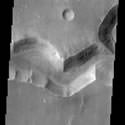
Now in its final orbit, Mars Odyssey is getting to work searching for water on the surface of the planet. The most recent set of images returned are of a network of channels taken by the Thermal Emission Imaging System (THEMIS). The Nirgal Vallis is a channel 500 km long and 6 km wide at this point – astronomers believe that gullies on the side of the channel were formed when water erupted to the surface.

This THEMIS image shows a sinuous valley network channel with sharp bends cutting across the cratered highlands of the southern hemisphere of Mars. The channel is named Nirgal Vallis, which is from the Babylonian word for “Mars”. Nirgal Vallis is a channel with a total length of approximately 500 km. It is approximately 6 km wide in this region. Gullies and alluvial deposits discovered by Mars Global Surveyor are clearly visible on the polar-facing (south) wall and floor of Nirgal Vallis. These gullies appear to emanate from a specific layer in the walls. There is a pronounced sparsity of gullies on the equator-ward facing slopes. The gullies have been proposed to have formed by the subsurface release of water. Patches of dunes are also seen on the channel floor, notably along the edges of the channel floor near the canyon walls. There is still debate within the scientific community as to how valley networks themselves form: surface runoff (rainfall/snowmelt) or headward erosion via groundwater sapping. This image is approximately 22 km wide and 60 km in length; north is toward the top.

Original Source: ASU News Release

First Odyssey Photos Released

It’s only the first few photographs from Mars Odyssey, but scientists are already excited about what the spacecraft has turned up on the surface of Mars. Odyssey, which began mapping the planet last week, has detected significant amounts of hydrogen near the planet’s south pole. Scientists believe this hydrogen is evidence of water ice – and not just surface frost, but a large quantity of frozen water.

Initial science data from NASA’s Mars Odyssey spacecraft, which began its mapping mission last week, portend some tantalizing findings by the newest Martian visitor, including possible identification of significant amounts of frozen water.

“We are delighted with the quality of data we’re seeing,” said Dr. Steve Saunders, Odyssey project scientist at JPL. “We’ll use it to build on what we’ve learned from Mars Global Surveyor and other missions. Now we may actually see water rather than guessing where it is or was. And with the thermal images we are able to examine surface geology from a new perspective.”

“These preliminary Odyssey observations are the ‘tip of the iceberg’ of the science results that are soon to come, so stay tuned,” said Dr. Jim Garvin, lead scientist of the Mars Exploration Program at NASA Headquarters, Washington, D.C.

New images taken by the thermal emission imaging system show the temperature of the surface at a remarkable level of clarity and detail during both the martian day and night. The images can be seen at http://mars.jpl.nasa.gov/odyssey and http://themis.asu.edu/latest . Odyssey’s camera system is studying Mars’ surface mineralogy to reveal geologic history. The thermal infrared images are 30 times sharper than previously available images, and the camera’s visible-light images will fill a gap in resolution between Viking Orbiter and Mars Global Surveyor pictures.

Initial measurements by the gamma ray spectrometer instrument suite show the presence of significant amounts of hydrogen in the south polar region of Mars. The high hydrogen content is most likely due to water ice, though the amount of ice cannot be quantified yet. Further analysis will be conducted to confirm the interpretation. The detection of hydrogen is based both on the intensity of gamma rays emitted by hydrogen, and by the intensity of neutrons that are moderated by hydrogen. The neutron intensity was observed by the high energy neutron detector and the neutron spectrometer. Additional information is available online at http://grs.lpl.arizona.edu/results/presscon1/ .

“The preliminary assessment of the gamma-ray spectrometer data indicates the likely presence of hydrogen in the upper few feet of the martian surface as sampled at spatial scales approximately 400 miles across. Further analysis and another month or so of mapping will permit more quantitative assessment of these observations and allow for a refined interpretation,” said Garvin.

Measurements made by the martian radiation environment experiment during Odyssey’s cruise phase suggest that the daily dose of radiation experienced by astronauts on their way from Earth to Mars would be more than twice the dose endured by astronauts on the International Space Station. Investigators are in the process of troubleshooting the radiation experiment to determine why the instrument stopped communicating and was turned off in August 2001.

The Jet Propulsion Laboratory manages the 2001 Mars Odyssey mission for NASA’s Office of Space Science, Washington, D.C. Investigators at Arizona State University in Tempe, the University of Arizona in Tucson, and NASA’s Johnson Space Center, Houston, operate the science instruments. Additional science partners are located at the Russian Aviation and Space Agency, which provided the high-energy neutron detector, and at Los Alamos National Laboratories, New Mexico, which provided the neutron spectrometer. Lockheed Martin Astronautics, Denver, is the prime contractor for the project, and developed and built the orbiter. Mission operations are conducted jointly from Lockheed Martin and from JPL, a division of the California Institute of Technology in Pasadena.

Original Source: NASA News Release

Martian Floods Could be Recent

Scientists from the University of Arizona believe that water may have erupted onto the surface of Mars as recently as 10 million years ago. As much as 600 cubic kilometres of water (four times the water in Lake Erie) may have poured out of fissures in the Cerberus Plains just north of the Martian equator. The scientists formed their theory after studying images taken of the region by the Mars Global Surveyor spacecraft.

Five New Martian Meteorites Discovered

Scientists believe they’ve found an additional five meteorites that originated from the planet Mars. The new rocks were discovered during recent expeditions to Antarctica and the deserts of the Middle East and Africa ? the best places for discovering the precious objects from space. This brings the total number of known Martian rocks to 24, and will provide researchers with additional specimens to analyze for evidence of past (or current) life on Mars.