2 Days Out from the Red Planet, India’s MOM Probe Test Fires Main Engine for Mars Orbit Insertion

India’s Mars Orbiter Mission (MOM) is closing in on the Red Planet and the Mars Orbit Insertion engine firing when it arrives on September 24, 2014 after its 10 month interplanetary journey. Credit ISRO

Two days out from her history making date with destiny, India’s Mars Orbiter Mission (MOM) successfully completed a crucial test firing of the spacecraft’s main liquid engine to confirm its operational readiness for the critical Mars Orbital Insertion (MOI) engine firing on Wednesday morning Sept. 24 IST (Tuesday evening Sept. 23 EDT).

Engineers at the Indian Space Research Organization (ISRO) which designed and developed MOM successfully fired the probes 440 Newton Liquid Apogee Motor (LAM) earlier today, Sept. 22, 2014, for a duration of 3.968 seconds at 1430 hrs IST (Indian Standard Time), according to today’s announcement from ISRO.

“We had a perfect burn for four seconds as programmed. MOM will now go-ahead with the nominal plan for Mars Orbital Insertion,” said ISRO.
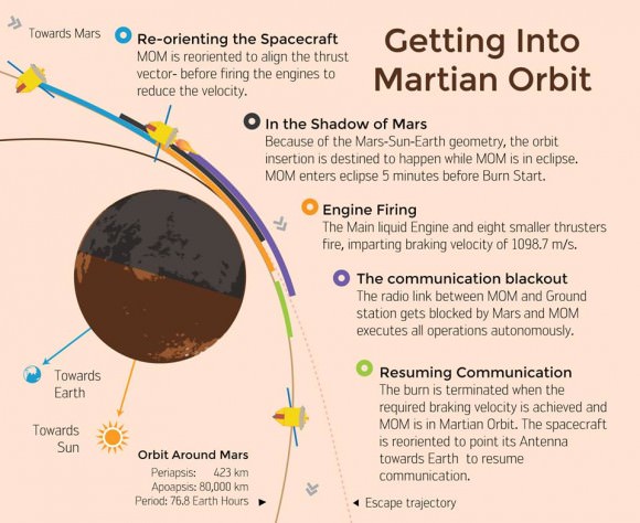
ISRO's Mars Orbiter Mission - The plan of action for Mars Orbit Insertion on September 24. Credit ISRO
ISRO’s Mars Orbiter Mission – The plan of action for Mars Orbit Insertion on September 24. Credit ISRO

MOM counts as India’s first interplanetary voyager and the nation’s first manmade object to orbit the 4th rock from our Sun – if all goes well.

The LAM was last fired over nine months ago on December 01, 2013 to inject MOM into a ten month long interplanetary Trans Mars Trajectory.

Today’s operation verified that LAM is fully operational to perform the do-or-die MOI braking burn on Sept. 24 targeted for 07:17:32 hrs IST (Sept. 23, 9:47:32 p.m. EDT) that will place the probe into a highly elliptical 377 km x 80,000 km orbit around the Red Planet.

You can watch all the action live on ISRO’s website during the streaming webcast starting at 6:45 IST (9:15 p.m. EDT): http://www.isro.org/

The burn was also marks the spacecraft’s final Trajectory Correction Maneuver known as TCM-4 and changed its velocity by 2.18 meters/second.

“The trajectory has been corrected,” said ISRO.

The $69 Million probe is being continuously monitored by the Indian Deep Space Network (IDSN) and NASA JPL’s Deep Space Network (DSN) to maintain its course.
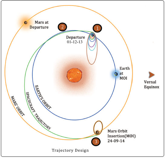
Trans Mars Injection (TMI), carried out on Dec 01, 2013 at 00:49 hrs (IST) has moved the spacecraft in the Mars Transfer Trajectory (MTT). With TMI the Earth orbiting phase of the spacecraft ended and the spacecraft is now on a course to encounter Mars after a journey of about 10 months around the Sun. Credit: ISRO

ISRO space engineers are taking care to precisely navigate MOM to keep it on course during its long heliocentric trajectory from Earth to Mars through a series of in flight Trajectory Correction Maneuvers (TCMs).

The last TCM was successfully performed on June 11 by firing the spacecraft’s 22 Newton thrusters for a duration of 16 seconds. TCM-1 was conducted on December 11, 2013 by firing the 22 Newton Thrusters for 40.5 seconds.

Engineers determined that a TCM planned for August was not needed.

On “D-Day” as ISRO calls it, the LAM and the eight smaller 22 Newton liquid fueled engines are scheduled to fire for a duration of about 24 minutes.

The MOI braking burn will be carried out fully autonomously since MOM will be eclipsed by Mars due to the Sun-Earth-Mars geometry about five minutes prior to initiation of the engine firing.

Round trip radio signals communicating with MOM now take some 21 minutes.

The 1,350 kilogram (2,980 pound) probe has been streaking through space for over ten months.

MOM follows hot on the heels of NASA’s MAVEN spacecraft which successfully achieved Red Planet orbit less than a day ago on Sunday, Sept. 22, 2014.

“We wish a successful MOI for MOM,” said Bruce Jakosky, MAVEN principal investigator with the Laboratory for Atmospheric and Space Physics at the University of Colorado, Boulder (CU/LASP) at MAVEN’s post MOI briefing earlier today.

MOM was launched on Nov. 5, 2013 from India’s spaceport at the Satish Dhawan Space Centre, Sriharikota, atop the nation’s indigenous four stage Polar Satellite Launch Vehicle (PSLV) which placed the probe into its initial Earth parking orbit.

Watch this cool animation showing the interplanetary path of MOM and MAVEN from Earth to Mars sent to me be an appreciative reader – Sankaranarayanan K V:

Although MOM’s main objective is a demonstration of technological capabilities, she will also study the planet’s atmosphere and surface.

The probe is equipped with five indigenous instruments to conduct meaningful science – including a tri-color imager (MCC) and a methane gas sniffer (MSM) to study the Red Planet’s atmosphere, morphology, mineralogy and surface features. Methane on Earth originates from both geological and biological sources – and could be a potential marker for the existence of Martian microbes.

Both MAVEN’s and MOM’s goal is to study the Martian atmosphere , unlock the mysteries of its current atmosphere and determine how, why and when the atmosphere and liquid water was lost – and how this transformed Mars’ climate into its cold, desiccated state of today.

If all goes well, India will join an elite club of only four who have launched probes that successfully investigated the Red Planet from orbit or the surface – following the Soviet Union, the United States and the European Space Agency (ESA).

Stay tuned here for Ken’s continuing MOM, MAVEN, Rosetta, Opportunity, Curiosity, Mars rover and more Earth and planetary science and human spaceflight news.

Ken Kremer

Blastoff of the Indian developed Mars Orbiter Mission (MOM) on Nov. 5, 2013 from the Indian Space Research Organization’s (ISRO) Satish Dhawan Space Centre SHAR, Sriharikota. Credit: ISRO

MAVEN Arrives at Mars! Parks Safely in Orbit

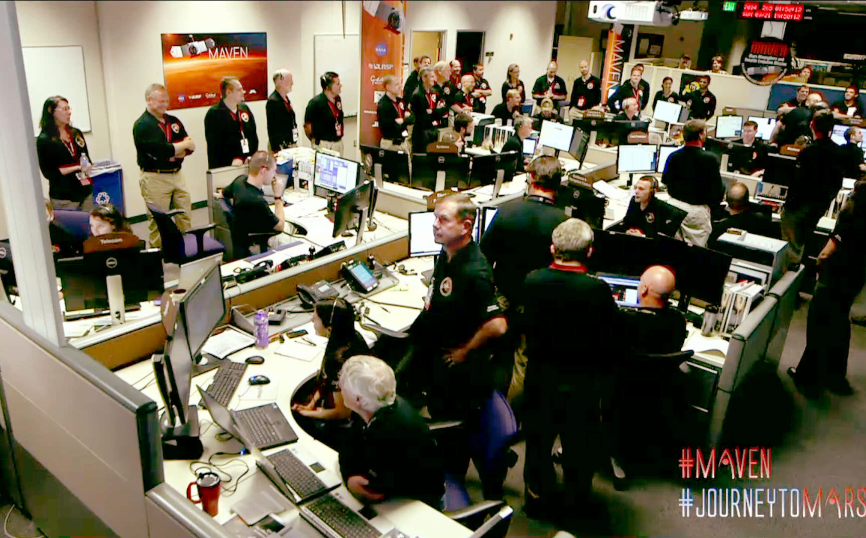
The control room at Lockheed Martin shortly before MAVEN successfully entered Mars orbit tonight September 21, 2014. Credit: NASA-TV

138 million miles and 10 months journey from planet Earth, MAVEN moved into its new home around the planet Mars this evening. Flight controllers at Lockheed Martin Space Systems in Littleton, Colorado anxiously monitored the spacecraft’s progress as onboard computers successfully eased the Mars Atmosphere and Volatile EvolutioN (MAVEN) spacecraft into Mars orbit at 10:24 p.m. Eastern Daylight Time. 

Shortly before orbital insertion, six small thrusters were fired to steady the spacecraft so it would enter orbit in the correct orientation. This was followed by a 33-minute burn to slow it down enough for Mars’ gravity to capture the craft into an elliptical orbit with a period of 35 hours. Because it takes radio signals traveling at the speed of light 12 minutes to cross the gap between Mars and Earth, the entire orbital sequence was executed by onboard computers. There’s no chance to change course or make corrections, so the software has to work flawlessly. It did. The burn, as they said was “nominal”, science-speak for came off without a hitch.

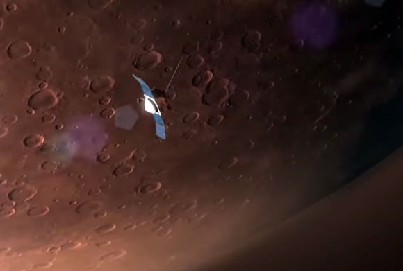
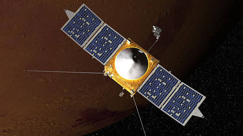
Simulation of MAVEN in Martian orbit. Credit: NASA
Simulation of MAVEN in orbit around Mars. The craft’s unique aerodynamically curved solar panels allow it to dive more deeply into the Martian atmosphere. Credit: NASA

“This was a very big day for MAVEN,” said David Mitchell, MAVEN project manager from NASA’s Goddard Space Flight Center, Greenbelt, Maryland. “We’re very excited to join the constellation of spacecraft in orbit at Mars and on the surface of the Red Planet. Congratulations to the team for a job well done today.”

Over the next six weeks, controllers will test MAVEN’s instruments and shape its orbit into a long ellipse with a period of 4.5 hours and a low point of just 93 miles (150 km), close enough to get a taste of the planet’s upper atmosphere. MAVEN’s one-Earth-year long primary mission will study the composition and structure of Mars’ atmosphere and how it’s affected by the sun and solar wind. At least 2,000 Astronomers want to determine how the planet evolved from a more temperate climate to the current dry, frigid desert.

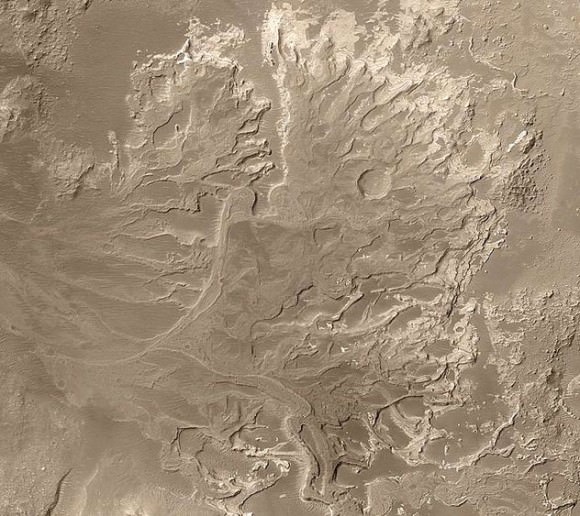
Evidence for ancient water flows on Mars - a delta in Eberswalde Crater. Credit: NASA
Evidence for ancient water flows on Mars – a delta in Eberswalde Crater. Credit: NASA

Vast quantities of water once flowed over the dusty red rocks of Mars as evidenced by ancient riverbeds, outflow channels carved by powerful floods, and rocks rounded by the action of water. For liquid water to flow on its surface without vaporizing straight into space, the planet must have had a much denser atmosphere at one time.

Mars may have been much more like Earth is today 3-4 billion years ago with a thicker atmosphere and water flowing across its surface. Today, it's evolved into dry, cold planet with an atmosphere as thin as Scrooge's gruel. Credit: NASA
Three to four billion years ago, Mars may have been much more like Earth with a thicker atmosphere and water flowing across its surface (left). Over time,  it evolved into a dry, cold planet with an atmosphere too thin to support liquid water. Credit: NASA

Mars’ atmospheric pressure is now less than 1% that of Earth’s. As for the water, what’s left today appears locked up as ice in the polar caps and subsurface ice. So where did it go all the air go? Not into making rocks apparently. On Earth, much of the carbon dioxide from volcanic outgassing in the planet’s youth dissolved in water and combined with rocks to form carbon-bearing rocks called carbonates. So far, carbonates appear to be rare on Mars. Little has been seen from orbit and in situ with the rovers.

Illustration of electrons and protons in the solar wind slamming into and ionizing atoms in Mars upper atmosphere. Once ionized, the atoms may be carried away by the wind. Credit: NASA

During the year-long mission, MAVEN will dip in and out of the atmosphere some 2,000 times or more to measure what and how much Mars is losing to space. Without the protection of a global magnetic field like the Earth’s,  it’s thought that the solar wind eats away at the Martian atmosphere by ionizing (knocking off electrons) its atoms and molecules. Once ionized, the atoms swirl up the magnetic field embedded in the wind and are carried away from the planet.

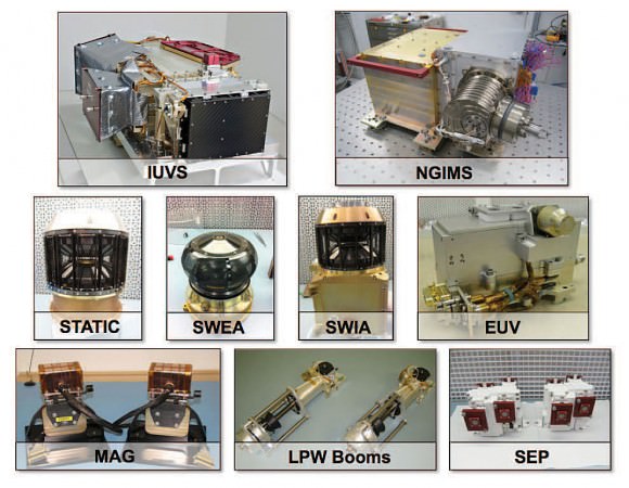
MAVEN’s suite of instruments will provide the measurements essential to understanding the evolution of the Martian atmosphere. (Courtesy LASP/MAVEN)
MAVEN’s suite of instruments will provide the measurements essential to understanding the evolution of the Martian atmosphere. Courtesy LASP/MAVEN

Scientists will coordinate with the Curiosity rover, which can determine the atmospheric makeup at ground level. Although MAVEN won’t be taking pictures, its three packages of instruments will be working daily to fill gaps in the story of how Mars became the Red Planet and we the Blue.

For more on the ongoing progress of MAVEN later tonight and tomorrow, stop by NASA TV online. You can also stay in touch by following the hashtags #MAVEN and #JourneytoMars on social media channels including Twitter, Instagram and Facebook. Twitter updates will be posted throughout on the agency’s official accounts @NASA, @MAVEN2Mars and @NASASocial.

Watch Live as MAVEN Meets Mars!

MAVEN Meets Mars on Sept. 21, 2014. Credit: NASA.

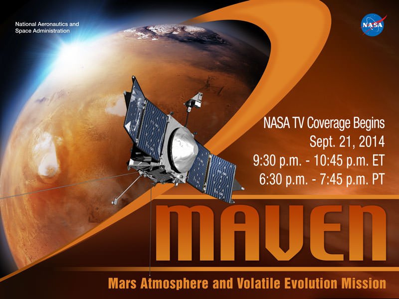
Watch here live, below, for the Mars orbital insertion of the Mars Atmosphere and Volatile Evolution (MAVEN) spacecraft, on Sunday, September 21 (or early Sept. 22 depending on your time zone) from 9:30 to 10:45 p.m. EDT, 01:30 to 02:45 UTC). The NASA TV broadcast feed will originate from the Lockheed Martin Facility in Littleton, Colorado, and will feature live camera views of mission control, interviews with senior NASA officials and mission team members, and mission video footage. The spacecraft’s mission timeline will place the spacecraft in orbit at approximately 9:50 p.m. EDT (01:50 UTC).


Broadcast live streaming video on Ustream

Coverage will wrap up with a post-orbit insertion news conference, targeted for about two hours after orbital insertion begins.

Members of the public are invited to follow the day-long NASA Social event on Sunday by following the hashtags #MAVEN and #JourneytoMars on social media channels including Twitter, Instagram and Facebook. Twitter updates will be posted throughout on the agency’s official accounts @NASA, @MAVEN2Mars and @NASASocial.

MAVEN launched Nov. 18, 2013, from Cape Canaveral Air Force Station in Florida, carrying three instrument packages. It is the first spacecraft dedicated to exploring the upper atmosphere of Mars. The mission’s goal is to determine how the loss of atmospheric gas to space played a role in changing the Martian climate through time.

How NASA’s Next Mars Spacecraft Will Greet The Red Planet On Sunday

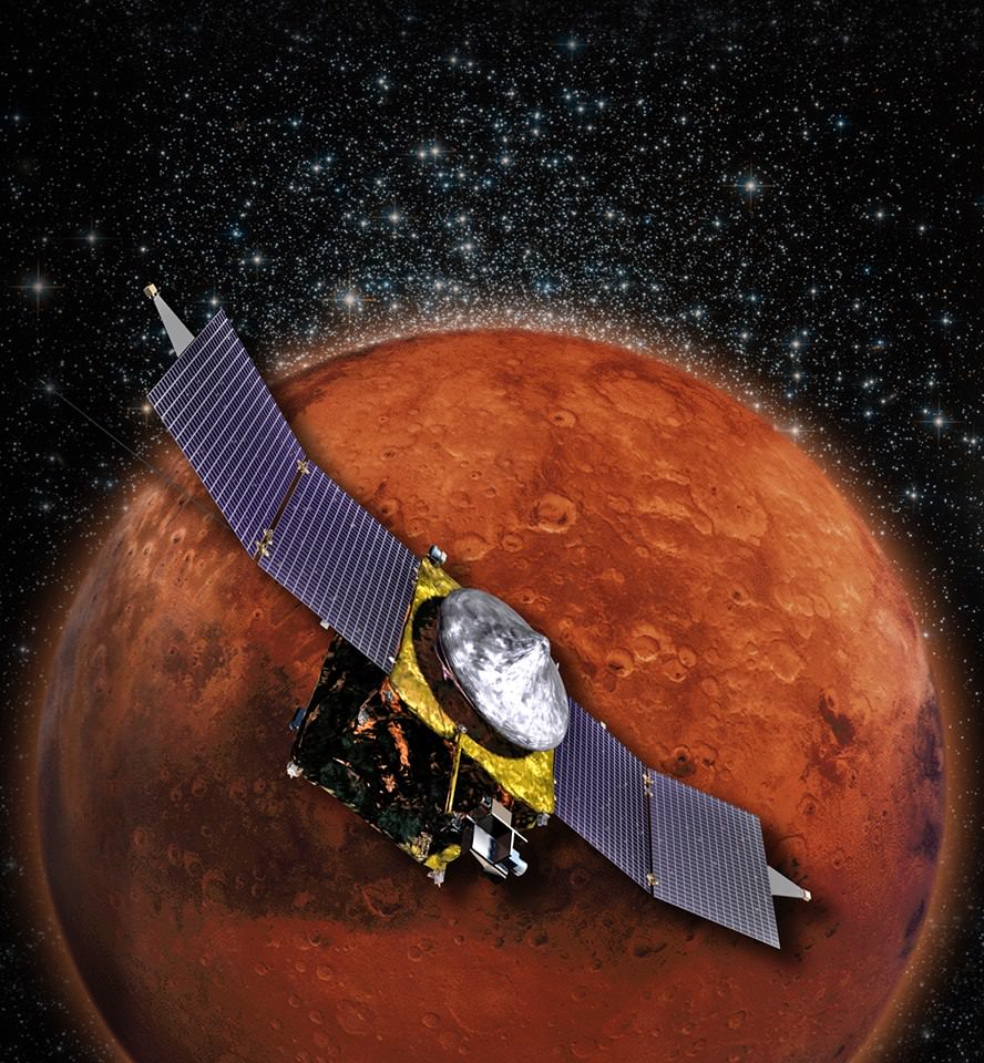
An artist concept of MAVEN in orbit around Mars. (Credit: NASA's Goddard Spaceflight Center).

NASA’s Mars Atmosphere and Volatile Evolution (MAVEN) orbiter is oh-so-close to its destination after a 10-month journey. It’s scheduled to arrive in orbit Sunday (Sept. 21) around 9:50 p.m. EDT (1:50 a.m. UTC) if all goes well, but there are a few things that need to happen, in order, first.

One big obstacle is already out of the way. MAVEN controllers had expected to do final engine burn tweaks to put it on the right trajectory, but the mission is so on-target that it won’t be needed.

“#MAVEN orbit insertion sequence has been activated on the s/c. No additional ground intervention is needed to enter #Mars’ orbit on Sunday,” the official account tweeted yesterday (Sept. 18).

So what does the sequence entail? MAVEN will need to turn on its six thruster engines for a 33-minute braking maneuver to slow it down. This will allow the gravity of Mars to “capture” the spacecraft into an elliptical or oval-shaped orbit.

Should that all go safely, MAVEN still has a lot of work to do before being ready to capture information about the upper atmosphere of the Red Planet. All spacecraft go through a commissioning phase to ensure their instruments are working correctly and that they are in the correct orbit and orientation to do observations.

As such, controllers will spend about six weeks moving MAVEN into a more circular orbit and testing out its instruments. Usually this period is done without interruption, but NASA wants to capture information when Comet Siding Spring comes whizzing by Mars Oct. 19.

Controllers are interested in learning about the comet and its effect on the upper atmosphere, so they will stop the commissioning to make those measurements. MAVEN will also be oriented in such a way that its solar panels are protected as much as possible from the dust, although scientists now believe the risk of strikes is very low.

This graphic depicts the orbit of comet C/2013 A1 Siding Spring as it swings around the sun in 2014. On Oct. 19, 2014 the comet will have a very close pass at Mars. Its nucleus will miss Mars by about 82,000 miles (132,000 kilometers).   Credit: NASA/JPL-Caltech
This graphic depicts the orbit of comet C/2013 A1 Siding Spring as it swings around the sun in 2014. On Oct. 19, 2014 the comet will have a very close pass at Mars. Its nucleus will miss Mars by about 82,000 miles (132,000 kilometers). Credit: NASA/JPL-Caltech

MAVEN is expected to work at Mars for a year, but investigators are hoping it will be for longer so that the atmosphere can be tracked through more of a solar cycle. The Sun’s activity is a major influencer on the atmosphere and the “stripping” of molecules from it over time, which could have thinned Mars’ atmosphere in the ancient past.

The spacecraft will also serve as a backup communications and data relay for the Opportunity and Curiosity rovers on the surface, which might be needed if some of the older NASA Mars spacecraft that fulfill that function experience technical difficulties.

Sandy Ridges Pose A Mystery For Future Martian Beach Vacations

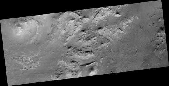
A September 2014 image from the High Resolution Imaging Science Experiment (HiRISE) on the Mars Reconnaissance Orbiter showing transverse aeolian ridges. Credit: NASA/JPL/University of Arizona

What are these thick dune-like features on Mars, and how were they formed? Scientists are still trying to puzzle out these ridges, which you can see above in a more tropical region of the Red Planet called Iapygia, which is south of Syrtis Major. The thick ridges were captured from orbit by the Mars Reconnaissance Orbiter’s High Resolution Imaging Science Experiment (HiRISE), and we’ve included some more intriguing pictures below the jump.

“Called transverse aeolian ridges, or TARs, the features stand up to 6 meters tall and are spaced a few tens of meters apart. They are typically oriented transverse to modern day wind directions, and often found in channels and crater interiors,” read an update on the University of Arizona’s HiRISE blog.

“The physical process that produces these features is still mysterious. Most TARs display no evidence of internal structure, so it is difficult to discern exactly how they were formed.”

A wider view of the Iapygia region on Mars, where transverse aeolian ridges (TARs) -- dune-like features -- were spotted in 2014. PIcture taken by the High Resolution Imaging Science Experiment (HiRISE) on the Mars Reconnaissance Orbiter. Credit: NASA/JPL/University of Arizona
A wider view of the Iapygia region on Mars, where transverse aeolian ridges (TARs) — dune-like features — were spotted in 2014. PIcture taken by the High Resolution Imaging Science Experiment (HiRISE) on the Mars Reconnaissance Orbiter. Credit: NASA/JPL/University of Arizona

This picture from the NASA spacecraft was taken in Iapygia, which is south of Syrtis Major. While scientists say these look similar to TARs in other parts of the Red Planet, the features have layers on the northwest faces and a paucity on the southern side.

Scientists suggest it’s because these TARs may have had wedge-shaped layers, which hints that they would have gotten taller as material was added to the ridges. They hope to do further studies to learn more about how TARs formed in other regions on Mars.

We’ve included other recent releases from the HiRISE catalog below, so enjoy the Martian vistas!

An image of Eridania Basin, a southern region of Mars that once could been a lake or inland sea. Picture taken by the High Resolution Imaging Science Experiment (HiRISE) on the Mars Reconnaissance Orbiter. Credit: NASA/JPL/University of Arizona
Scientists are still puzzling out the nature and formation of these light-toned deposits in the old Vinogradov Crater on Mars. Picture taken by the High Resolution Imaging Science Experiment (HiRISE) on the Mars Reconnaissance Orbiter. Credit: NASA/JPL/University of Arizona
Older lava flows in Daedalia Planum on Mars. Picture taken by the High Resolution Imaging Science Experiment (HiRISE) on the Mars Reconnaissance Orbiter. Credit: NASA/JPL/University of Arizona

Repaired Opportunity Rover Readies For ‘Marathon Valley’ As It Transmits Martian Images

The Opportunity rover is at the west rim of Endeavour Crater on Mars in this image sent on Sol 3,783 in September 2014 -- after a successful Flash memory reset. Credit: NASA/JPL-Caltech/Cornell Univ./Arizona State Univ.

With a newly cleared memory, it’s time for Opportunity to resume the next stage of its long, long Martian drive. The next major goal for the long-lived rover is to go to Marathon Valley, a spot that (in images from orbit) appears to have clay minerals on site. Clay tends to form in the presence of water, so examining the region could provide more information about Mars’ wet, ancient past.

The rover has driven further on Mars than any other human-made machine; as of Sept. 9, it had reached 25.28 miles (40.69 kilometers). But signs of age are showing as the rover moves through its 11th Earth year on Mars.

NASA recently halted science operations for a few days to reformat the rover’s Flash memory, which was causing several reboots. The remote repair worked perfectly and the rover is ready to resume work, NASA said in an update Sept. 12.

Ready to roll: the Opportunity rover's wheels and tracks are visible in this picture taken on Mars on Sol 3,783 in September 2014. Credit: NASA/JPL-Caltech/Cornell Univ./Arizona State Univ.
Ready to roll: the Opportunity rover’s wheels and tracks are visible in this picture taken on Mars on Sol 3,783 in September 2014. Credit: NASA/JPL-Caltech/Cornell Univ./Arizona State Univ.

A NASA planetary senior review panel from early September, which was evaluating the science value of several extended missions, said there are “software and communication issues that afflict the rover” that could affect its ability to send data. (This was written before the memory reformat.)

The major goal of Opportunity’s latest extended mission, the review continued, is to find out what habitability conditions existed on Mars. This includes looking at the water, the geology and the environment.

“This will be achieved by measurements of rocks and soils, as well as atmospheric observations, as it traverses from Murray Ridge to Cape Tribulation,” the report read.

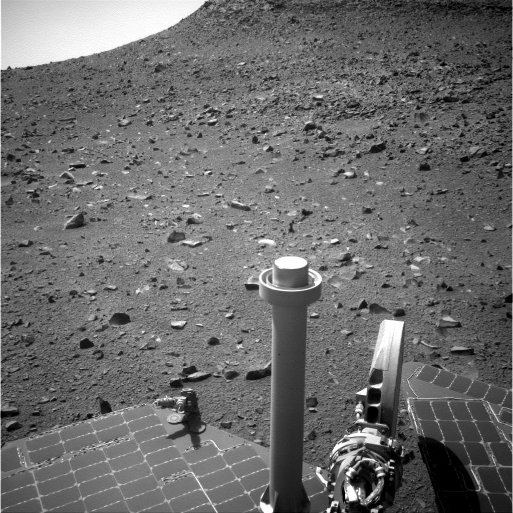
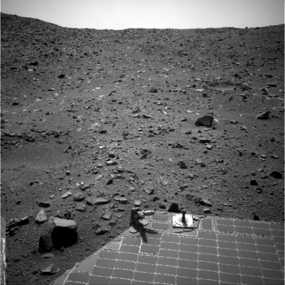
A still from the Opportunity rover's navigation camera taken on Sol 3,783 in September 2014. At bottom is part of the solar panel cells used to power the Martian rover. Credit: NASA/JPL-Caltech/Cornell Univ./Arizona State Univ.
A still from the Opportunity rover’s navigation camera taken on Sol 3,783 in September 2014. At bottom is part of the solar panel cells used to power the Martian rover. Credit: NASA/JPL-Caltech/Cornell Univ./Arizona State Univ.

“This extended mission will focus on the orbitally detected phyllosilicate deposits near Endeavour crater, which are considered to represent deposits from the ancient Noachian period. This would represent the first time that such ancient deposits have been analyzed on the Martian surface.”

The report further cautioned that there is no proof yet that the phyllosilicates (which are sheet salt silicate materials made of silicon and oxygen) are from the Noachian era, which represents geology that is more than 3.5 billion years old (depending on which source you consult). It added, however, that Opportunity is expected to be able to complete the science.

Meanwhile, enjoy these pictures from the rim of Endeavour Crater that Opportunity sent in the past few days.

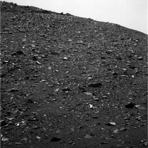
Rocks scattered across the Martian vista in this picture captured by the Opportunity rover on Sol 3,783. Credit: NASA/JPL-Caltech/Cornell Univ./Arizona State Univ.
Two of Opportunity's six wheels are visible in this shot from the rear hazcam on Sol 3,780, taken on Mars in September 2014. Credit: NASA/JPL-Caltech/Cornell Univ./Arizona State Univ.
Two of Opportunity’s six wheels are visible in this shot from the rear hazcam on Sol 3,780, taken on Mars in September 2014. Credit: NASA/JPL-Caltech/Cornell Univ./Arizona State Univ.
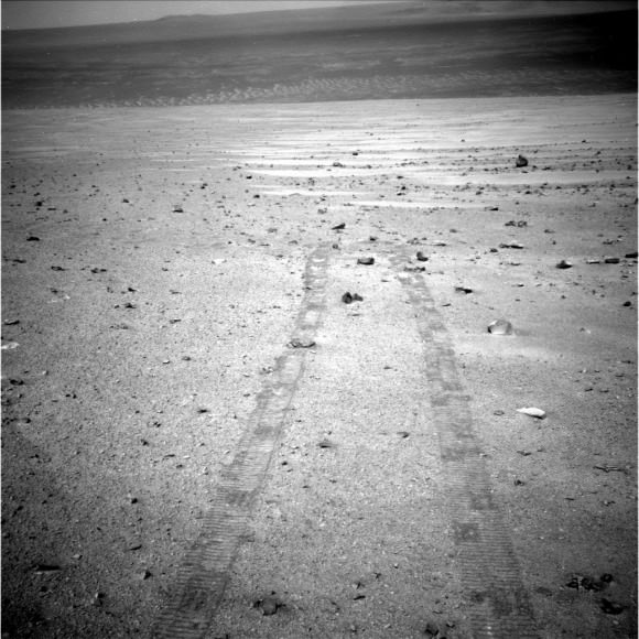
Tracks from Opportunity stretch across this vista taken by the rover on Sol 3,781 in September 2014. Credit: NASA/JPL-Caltech/Cornell Univ./Arizona State Univ.

Martian Ctl-Alt-Del: NASA Resets Opportunity Rover’s Memory, Stopping The Science Hiatus

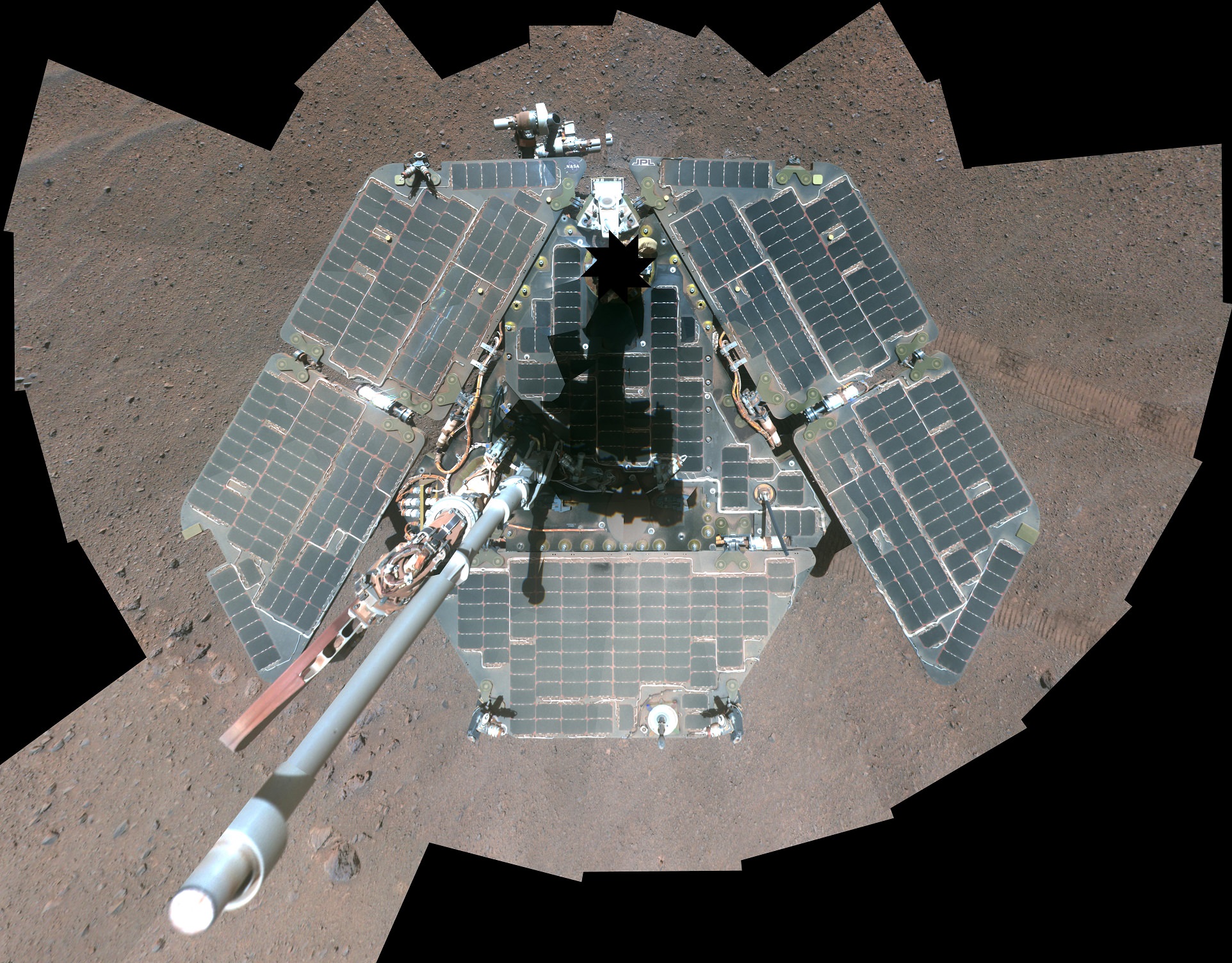
A self-portrait of the Opportunity rover shortly after dust cleared its solar panels in March 2014. Credit: NASA/JPL-Caltech/Cornell Univ./Arizona State Univ.

In fantastic news for the long-running Opportunity mission on Mars, NASA says the rover’s much-needed memory reset worked out perfectly. The rover was unable to perform science or beam pictures back to Earth because portions of its flash memory — which can store information even when the rover is turned off — were beginning to wear out.

The reboot means the rover is soon going to be on the move again as it continues exploring the rim of Endeavour Crater, tacking on nearly a marathon of miles that Opportunity has racked up on Mars since 2004.

“The rover’s Flash file system was successfully reformatted on Sol 3773 (Sept. 4, 2014),” NASA wrote in an update on the Mars Exploration Rover website late last week. “The Flash space available is slightly smaller (<1%) than before the reformat, consistent with the reformatting process flagging some bad cells to avoid.”

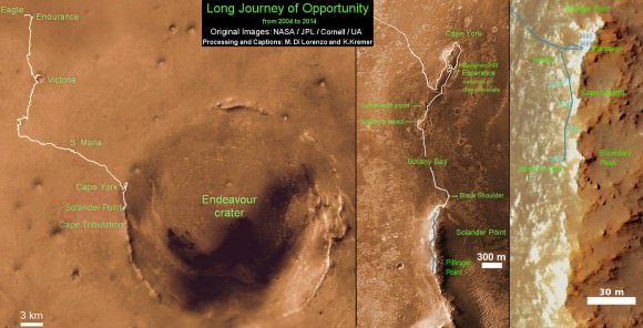
Traverse Map for NASA’s Opportunity rover from 2004 to 2014 - A Decade on Mars.  This map shows the entire path the rover has driven during a decade on Mars and over 3692 Sols, or Martian days, since landing inside Eagle Crater on Jan 24, 2004 to current location along Pillinger Point ridge south of Solander Point summit at the western rim of Endeavour Crater and heading to clay minerals at Cape Tribulation.  Opportunity discovered clay minerals at Esperance - indicative of a habitable zone.  Credit: NASA/JPL/Cornell/ASU/Marco Di Lorenzo/Ken Kremer
Traverse Map for NASA’s Opportunity rover from 2004 to 2014 – A Decade on Mars. This map shows the entire path the rover has driven during a decade on Mars and over 3692 Sols, or Martian days, since landing inside Eagle Crater on Jan 24, 2004 to current location along Pillinger Point ridge south of Solander Point summit at the western rim of Endeavour Crater and heading to clay minerals at Cape Tribulation. Opportunity discovered clay minerals at Esperance – indicative of a habitable zone. Credit: NASA/JPL/Cornell/ASU/Marco Di Lorenzo/Ken Kremer

After performing related activities to the reformat on Sept. 6 and 7, controllers tried to take Opportunity out for a drive. They decided to stop shortly after beginning on Sept. 9 because the visual odometry Opportunity was using wasn’t enough for navigation. The controllers plan to try it again, using different landmarks next time. Current odometer on the rover: 25.28 miles (40.69 kilometers).

Sept. 9 marked the 3,778th Martian day or “sol” that Opportunity has been at work on Mars. The rover was originally designed to last three Earth months on the Martian surface, but is still performing drives and science in its 11th year. (The rover’s twin, Spirit, died in a sand trap after sending its last transmission March 22, 2010.)

Opportunity, however, is facing funding challenges on Earth as NASA and its political stakeholders weigh which of the agency’s long-term missions should continue.

An Incredible Journey, Mars Curiosity Rover Reaches the Base of Mount Sharp

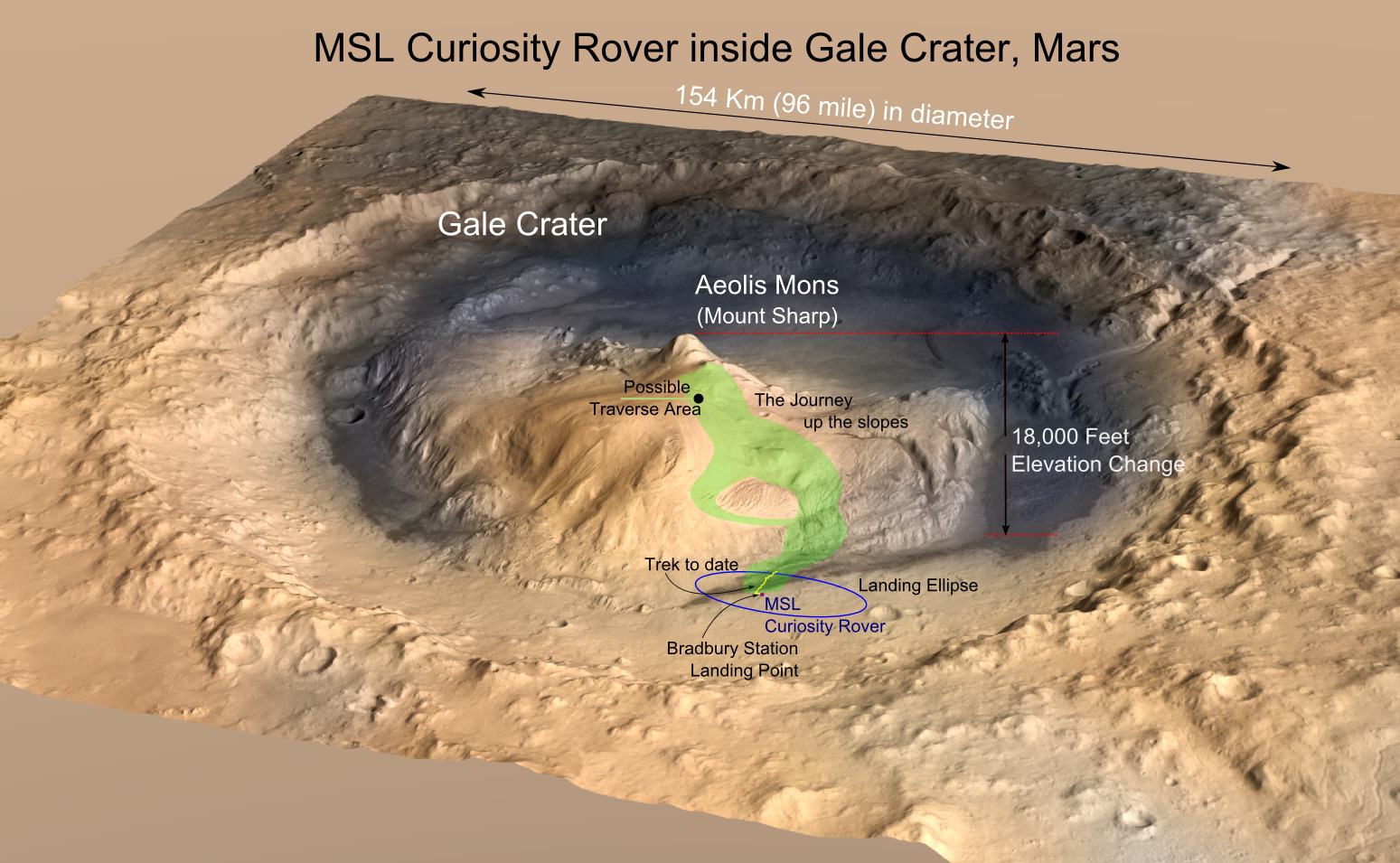
MRO image of Gale Crater illustrating the landing location and trek of the Rover Curiosity. Curiosity's images and data show that the Gale Crater held water for much longer than thought. (Credits: NASA/JPL, illustration, T.Reyes)

Scientists at the Jet Propulsion Laboratory have announced that the Mars Science Lab (MSL), Curiosity Rover, has reached the base of the central peak inside Gale Crater, Aeolis Mons also known as Mount Sharp. Mount Sharp is a prime objective of NASA’s Curiosity journey. The mountain is like a layer cake, holding a chronology of past events, one after the other, stacked upon each other over billions of years. It took two years and one month to reach this present point and what lies ahead is the beginning of an upward trek towards the peak of Mount Sharp, 5500 meters (18,000 feet) above the floor of Gale Crater. However, it is worth a look back and to consider what Mount Sharp represents to the mission.

For over 17 years, NASA robotic spacecraft have maintained a constant presence above or upon the surface of Mars. The Mars Pathfinder mission arrived on July 4, 1997, then quickly followed by Mars Global Surveyor on September 11 and since this time, there has always been at least one active Mars mission.

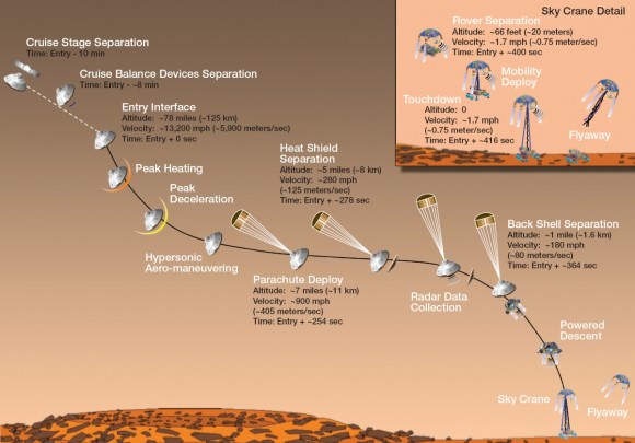
"Seven Minutes of Terror" - the Entry, Descent and Landing (EDL) of the Mars Science Lab (MSL) - Mars Curiosity Rover. (Credit: NASA/JPL)
“Seven Minutes of Terror” – the Entry, Descent and Landing (EDL) of the Mars Science Lab (MSL) – Mars Curiosity Rover. (Credit: NASA/JPL)

On November 26, 2011, the voyage of Mars Curiosity Rover began as a trek across 320 million kilometers (200 million miles) of the inner Solar System and culminated in the coined “Seven Minutes of Terror”. For seven long minutes, the MSL, the Mars Curiosity Rover, plowed straight into the Martian atmosphere – the entry, deployed a parachute – the descent, to slow down to about 320 km/hour (200 mph) then the Sky Crane with Rover under foot was released – the landing. With only seconds before an imminent hard impact, the Sky Crane hit the breaks, firing its rockets, then released Curiosity Rover on a tether. This was the Entry, Descent and Landing (EDL). All the while, it was the computer inside the Rover in control. When the tether was cut, the Sky Crane was forced to switch to a simpler processor within its system to complete a final scuttling of itself a few hundred meters away.

The Sky Crane gently lowered Curiosity to the landing point, christened Bradbury Station after the celebrated science fiction writer, Ray Bradbury, writer of the Martian Chronicles(c.1950), who passed away at age 91, 61 days before the landing on August 5, 2012. (recommended video – R. Bradbury reading “If Only We had been Taller” at the public event marking the arrival of Mariner 9 at Mars, November 12, 1971)


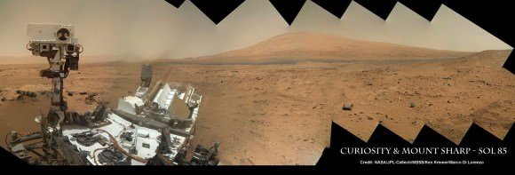
The ultimate Selfie - a self-protrait taken on anoher planet. This is the capability of the Mars Hand Lens Imager (MAHLI) camera, one of 5 instruments on the turret at the end of the 2.1 meter (7 ft), 30 kg (66 lb) Robotic Arm. On numerous occasions, Curiosity has taken self-portraits, many as mosaics. This on is on Sol (Mars day) 85, post landing, showing Curiosity with its destination - Aeolis Mons (Mt. Sharp) in the background. (Credit: NASA/JPL-Caltech/MSSS/Ken Kremer/Marco Di Lorenzo, "Curiosity Celebrates 90 Sols Scooping Mars and Snapping Amazing Self-Portrait with Mount Sharp")
The ultimate Selfie – a self-protrait taken on anoher planet. This is the capability of the Mars Hand Lens Imager (MAHLI) camera, one of 5 instruments on the turret at the end of the 2.1 meter (7 ft), 30 kg (66 lb) Robotic Arm. On numerous occasions, Curiosity has taken self-portraits, many as mosaics. This on is on Sol (Mars day) 85, post landing, showing Curiosity with its destination – Aeolis Mons (Mt. Sharp) in the background. (Credit: NASA/JPL-Caltech/MSSS/Ken Kremer/Marco Di Lorenzo, “Curiosity Celebrates 90 Sols Scooping Mars and Snapping Amazing Self-Portrait with Mount Sharp“)
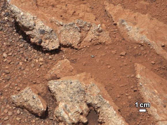
September 27, 2012: A rock outcrop called Link pops out from a Martian surface taken by the 100-millimeter Mast Camera on NASA’s Curiosity Mars rover September 2, 2012. Rounded gravel fragments, or clasts, up to a couple inches (few centimeters) in size are in a matrix of white material. The outcrop characteristics are consistent with a sedimentary conglomerate, or a rock that was formed by the deposition of water and is composed of many smaller rounded rocks cemented together. Scientists enhanced the color in this version to show the Martian scene as it would appear under the lighting conditions we have on Earth, which helps in analyzing the terrain. (NASA/JPL-Caltech/MSSS/Handout/Reuters)
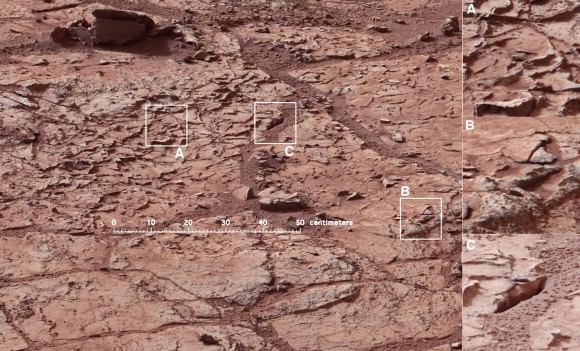
Mars Curiosity at the "John Klein" site on January 10, 2013 (Mars Sol 153). The Mastcam mosaic was taken from 5 meters (16 ft). The area is full of fractures and veins with intervening rock with concretions (small spherical concentrations of minerals). The enlargements show particular areas of interest. (A) Ridge-like veins protruding from the surface. (B) Shows discontinuities in the veins that likely extend beneath the surface. (C) Shows a hole developed in the sand that overlies a fracture, implying infiltration of sand down into the fracture system. To this author, the area around (A) seems like the remnants of dried mud chips or scales one finds in the dry areas of estuaries on Earth. (Credits: NASA/JPL)
Mars Curiosity at the “John Klein” site in Yellow Knife Bay on January 10, 2013 (Mars Sol 153). The Mastcam mosaic was taken from 5 meters (16 ft). The area is full of fractures and veins with intervening rock with concretions (small spherical concentrations of minerals). The enlargements show particular areas of interest. (A) Ridge-like veins protruding from the surface. (B) Shows discontinuities in the veins that likely extend beneath the surface. (C) Shows a hole developed in the sand that overlies a fracture, implying infiltration of sand down into the fracture system. To this author, the area around (A) seems similar to the remnants of dried mud chips or scales one finds in the dry areas of estuaries on Earth. (Credits: NASA/JPL)

What has followed in the last 25 months since the landing is simply staggering. Mars Curiosity Rover, with the most advanced array of instruments and tools ever delivered to a celestial body, has already delivered an immense trove of images and scientific data that is improving and changing our understanding of Mars.

HIRISE images from the orbiting MRO spacecraft are used to show the old and new routes of NASA's Mars Curiosity rover. The new route provides excellent access to many features in the Murray Formation. And it will eventually pass by the Murray Formation's namesake, Murray Buttes, previously considered to be the entry point to Mt. Sharp. (Credit: NASA/JPL-Caltech/Univ. of Arizona)
HIRISE images from the orbiting MRO spacecraft are used to show the old and new routes of NASA’s Mars Curiosity rover. The new route provides excellent access to many features in the Murray Formation. And it will eventually pass by the Murray Formation’s namesake, Murray Buttes, previously considered to be the entry point to Mt. Sharp. (Credit: NASA/JPL-Caltech/Univ. of Arizona)

Curiosity had been making progress towards an entry point to Mount Sharp called Murray Buttes, however, because of challenges that the terrain posed – sand dunes and treacherous rocks, they have chosen to enter at Pahrump Hills. Furthermore, the new entry to the lower slopes of Mount Sharp are considered scientifically more interesting. The boundary between the mountain and the crater-floor deposits is not an exact one but NASA scientists explained the reason for the announcement at this point:

“Both entry points lay along a boundary where the southern base layer of the mountain meets crater-floor deposits washed down from the crater’s northern rim.” The terrain is now primarily material from the mountain from here on upward.

Image taken by the MastCam of Curiosity Rover on August 23, 2012 which shows the buttes representing the base of Mount Sharp, including Murray Buttes. Today, two years later, Mars Curiosity now stands at entry points in the region of the buttes at 6.6 km (direct line distance). In the middle of the image is the boulder-strewn area in which much of Curiosity's wheel damage occurred. At top are the expansive series of sendiments that is the great interest of Mars researchers. (Credit: NASA/JPL)
Image taken by the MastCam of Curiosity Rover on August 23, 2012 which shows the buttes representing the base of Mount Sharp, including Murray Buttes. Today, two years later, Mars Curiosity now stands at entry points in the region of the buttes at 6.6 km (direct line distance). In the middle of the image is the boulder-strewn area in which much of Curiosity’s wheel damage occurred. At top are the expansive series of sendiments that is the great interest of Mars researchers. (Credit: NASA/JPL)

Mount Sharp is anything but the normal central peak of an impact crater. Gale crater at 154 km (96 miles) in diameter is what is called a complex crater. Beyond a certain size, depending on the gravity of the planet, craters will have a central peak. It is similar to the spike of water which is thrust upwards when you drop an object into a pool of water. Like the spike of water, an impact, thrusts regolith upwards and it collapses and coalesces into a central peak. However, with Mount Sharp there is something more. If the peak was nothing but a central impact peak, NASA with Mars Curiosity would not be trekking inside Gale Crater.

As data and analysis has accumulated from not just Mars Curiosity Rover but rather from all the active Mars missions, the models and hypotheses describing the structure and morphology on Mars has become more complex. This model and explanation of how Mount Sharp built up over billions of years uses deposition of ice and dust. Click to enlarge to review the five steps to making a layer cake mountain - Aeolis Mons (Mount Sharp). It is a process which is comparable to how the Martian polar caps formed. Illustration presented by Paul Niles (NASA Johnson Space Center) and Joseph Michalski (Planetary Science Insitute, UK)at the 43rd Lunar and Planetary Science Conference, The Woodlands, Texas)
As data and analysis has accumulated from not just Mars Curiosity Rover but rather from all the active Mars missions, the models and hypotheses describing the structure and morphology on Mars have become more complex. This model and explanation of how Mount Sharp built up over billions of years uses deposition of ice and dust. Click to enlarge and review the five steps to making a layer cake mountain – Mount Sharp. (Credit:  Illustration presented by Paul Niles (NASA Johnson Space Center) and Joseph Michalski (Planetary Science Insitute, UK)at the 43rd Lunar and Planetary Science Conference, The Woodlands, Texas)

Mars scientists believe that Gale crater after its creation was completely filled with sedimentary material from a series of huge floods passing over the surrounding terrain or by dust and ice deposits such as happened at the Martian polar caps. The deposition over 2 billion years left a series sedimentary layers that filled the crater.

Following the deposition of the layers, there was a long period of erosion which has finally led to the condition of the crater today. The erosion by some combination of aeolean (wind) forces and water (additional flooding), scooped out the huge crater, re-exposing most of the original depth. However, covering the original central peak are many sedimentary layers of debris. Gale crater’s original central peak actually remains completely hidden and covered by sedimentation. This is what has attracted scientists with Curiosity to the base of Mount Sharp.

The Mars Trek of NASA's Curiosity Rover from Bradbury Station (landing site) up to Martian Sol 743. The announcement that Curiosity has reached the base of Mt. Sharp is Sol 746. (Credit: NASA/JPL)
The trek of NASA’s Curiosity Rover from Bradbury Station (landing site, Sol 1) up to Martian Sol 743. The announcement that Curiosity had reached the base of Mt. Sharp is Sol 746. On Martian Sol 675, the Rover took its first step beyond its landing ellipse. (Credit: NASA/JPL)

Within the sedimentary layers covering Mount Sharp, there is a sequential record of the events that laid down the layers. Embedded in each of those layers is a record of the environmental conditions on Mars going back over 2 billion years. At the base are the oldest sedimentary layers and as Curiosity climbs the flanks of the mountain, it will step forward in time. The advanced instrumentation residing on and inside Curiosity will be able to analyze each layer for material content and also determine its age. Each layer and its age will reveal information such as how much water was present, whether the water was alkaline or acidic, if there is any organic compounds. The discovery of organic compounds on Mount Sharp could be, well, Earth shaking. There are organic compounds and then there are organic compounds that are linked to life and this search for organics is of very high importance to this mission.

Already, over the two year trek, Curiosity has seen numerous signs of the flow of water and sedimentation. At its first major waypoint, Glenelg, Curiosity stepped into an area called Yellow Knife Bay that showed numerous signs of past water. There were veins of magnesium  salt deposits embedded in the soil, sedimentation and even conglomerate rock such as that found in river beds.

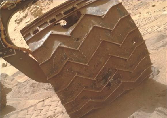
In late 2013, wear and tear accelerated on Curiosity's wheels, the result of crossing boulder-strewn terrain. Clearly signs of punctures, tears and dents are seen in the photo taken by Curiosity performing a self-inspection. While it certainly raised alarm, mission planners remain confident that it can be handled and will not limit the duration of the mission.(Credits: NASA/JPL)
In late 2013, wear and tear accelerated on Curiosity’s wheels, the result of crossing boulder-strewn terrain. Clearly signs of punctures, tears and dents are seen in the photo taken by Curiosity performing a self-inspection. While it certainly raised alarm, mission planners remain confident that it can be handled and will not limit the duration of the mission.(Credits: NASA/JPL)

There is another side to the terrain that Curiosity is traversing. The crater floor, essentially a flood plain has been particularly hard on the mobility system of Curiosity. This is to say that the sharp rocks it continues to encounter under foot are taking a toll on the wheels. Curiosity is now being operated in reverse in order to reduced the impact forces on its wheels.

Furthermore, while scientists are helping to choose the path of the rover, the Curiosity drivers who must assess the field ahead must find paths with fewer sharp rocks in order to slow the damage being done. The Mars Curiosity team is concerned but remain confident that the mobility system will be capable of surviving the ten year life span of the rover’s power supply. So, the momentous occasion is hardly a time to pause and reflect, the trek moves upward, northward to see what the layers on Mount Sharp will reveal.

There are competing hypotheses on how Mount Sharp evolved. Here are two worthy web pages with additional reading.

Crater mound a prize and puzzle for Mars rover“, Eric Hand, August 3, 2012

Big pile in Gale Crater“, R. Burnham, March 30, 2012

For further reading –

NASA’s Mars Curiosity Rover Arrives at Martian Mountain“, September 11, 2014

Recommended gateway to the Mars Curiosity web pages – a Curiosity Slide Show

Recent Universe Today articles on Curiosity: Sept 9,  Sept. 4,  Aug 23, Aug 20, Aug 16

Mars Panorama Shows Off Rocks, Mountains and Curiosity Rover

A portion of a panorama based on pictures taken by the Mars Curiosity rover on Sol 739 in September 2014. Credit: Andrew Bodrov/NASA/JPL-Caltech

Hey, it’s Mars in your browser! Panning around this scene that the Mars Curiosity rover captured earlier this month is the next best thing to being on the Red Planet.

Close by the rover’s is the terrain that proved far more challenging for mission planners than anticipated, and further in the distance you can see mountains — including the ultimate destination for this mission, Mount Sharp (Aeolis Mons).

The panorama, done by Andrew Bodrov, is based on pictures that Curiosity took during Sol 739 of its mission on Mars, which began in August 2012.

The Curiosity mission recently drew the concern of a NASA Senior Review panel, which said that the mission may be moving too fast to Mount Sharp and sacrificing looking carefully at other sites that could preserve signs of habitability.

The rover recently passed over a drilling target due to the nature of the rocks it was looking at, which were loose, unstable and at risk to the rover if they moved in an unpredictable way.

MAVEN Mars Orbiter Ideally Poised to Uniquely Map Comet Siding Spring Composition – Exclusive Interview with Principal Investigator Bruce Jakosky

MAVEN is NASA’s next Mars Orbiter and will investigate how the planet lost most of its atmosphere and water over time. Credit: NASA

MAVEN to conduct up close observations of Comet Siding Spring during Oct. 2014
MAVEN is NASA’s next Mars Orbiter and will investigate how the planet lost most of its atmosphere and water over time. Credit: NASA
Story updated[/caption]

NASA’s MAVEN Mars Orbiter is “ideally” instrumented to uniquely “map the composition of Comet Siding Spring” in great detail when it streaks past the Red Planet during an extremely close flyby on Oct. 19, 2014 – thereby providing a totally “unexpected science opportunity … and a before and after look at Mars atmosphere,” Prof. Bruce Jakosky, MAVEN’s Principal Investigator of CU-Boulder, CO, told Universe Today in an exclusive interview.

The probes state-of-the-art ultraviolet spectrograph will be the key instrument making the one-of-a-kind compositional observations of this Oort cloud comet making its first passage through the inner solar system on its millions year orbital journey.

“MAVEN’s Imaging Ultraviolet Spectrograph (IUVS) is the ideal way to observe the comet coma and tail,” Jakosky explained.

“The IUVS can do spectroscopy that will allow derivation of compositional information.”

“It will do imaging of the entire coma and tail, allowing mapping of composition.”

Comet: Siding Spring. The images above show -- before and after filtering -- comet C/2013 A1, also known as Siding Spring, as captured by Wide Field Camera 3 on NASA's Hubble Space Telescope.  Image Credit: NASA, ESA, and J.-Y. Li (Planetary Science Institute)
Comet: Siding Spring
The images above show — before and after filtering — comet C/2013 A1, also known as Siding Spring, as captured by Wide Field Camera 3 on NASA’s Hubble Space Telescope. Image Credit: NASA, ESA, and J.-Y. Li (Planetary Science Institute)

Moreover the UV spectrometer is the only one of its kind amongst NASA’s trio of Martian orbiters making its investigations completely unique.

“IUVS is the only ultraviolet spectrometer that will be observing the comet close up, and that gives the detailed compositional information,” Jakosky elaborated

And MAVEN, or the Mars Atmosphere and Volatile Evolution, is arriving just in the nick of time to fortuitously capture this fantastically rich data set of a pristine remnant from the solar system’s formation.

The spacecraft reaches Mars in less than 15 days. It will rendezvous with the Red Planet on Sept. 21 after a 10 month interplanetary journey from Earth.

Furthermore, since MAVEN’s purpose is the first ever detailed study of Mars upper atmosphere, it will get a before and after look at atmospheric changes.

“We’ll take advantage of this unexpected science opportunity to make observations both of the comet and of the Mars upper atmosphere before and after the comet passage – to look for any changes,” Jakosky stated.

How do MAVEN’s observations compare to NASA’s other orbiters Mars Odyssey (MO) and Mars Reconnaissance Orbiter (MRO), I asked?

“The data from the other orbiters will be complementary to the data from IUVS.”

“Visible light imaging from the other orbiters provides data on the structure of dust in the coma and tail. And infrared imaging provides information on the dust size distribution.”

IUVS is one of MAVENS’s nine science sensors in three instrument suites targeted to study why and exactly when did Mars undergo the radical climatic transformation.

How long will MAVEN make observations of Comet C/2013 A1 Siding Spring?

“We’ll be using IUVS to look at the comet itself, about 2 days before comet nucleus closest approach.”

“In addition, for about two days before and two days after nucleus closest approach, we’ll be using one of our “canned” sequences to observe the upper atmosphere and solar-wind interactions.”

“This will give us a detailed look at the upper atmosphere both before and after the comet, allowing us to look for differences.”

Describe the risk that Comet Siding Spring poses to MAVEN, and the timing?

“We have the encounter with Comet Siding Spring about 2/3 of the way through the commissioning phase we call transition.”

“We think that the risk to the spacecraft from comet dust is minimal, but we’ll be taking steps to reduce the risk even further so that we can move on toward our science mission.”

“Throughout this entire period, though, spacecraft and instrument health and safety come first.”

This graphic depicts the orbit of comet C/2013 A1 Siding Spring as it swings around the sun in 2014. On Oct. 19, 2014 the comet will have a very close pass at Mars. Its nucleus will miss Mars by about 82,000 miles (132,000 kilometers).   Credit: NASA/JPL-Caltech
This graphic depicts the orbit of comet C/2013 A1 Siding Spring as it swings around the sun in 2014. On Oct. 19, 2014 the comet will have a very close pass at Mars. Its nucleus will miss Mars by about 82,000 miles (132,000 kilometers). Credit: NASA/JPL-Caltech

What’s your overall hope and expectation from the comet encounter?

“Together [with the other orbiters], I’m hoping it will all provide quite a data set!

“From Mars, the comet truly will fill the sky!” Jakosky gushed.

The comet’s nucleus will fly by Mars at a distance of only about 82,000 miles (132,000 kilometers) at 2:28 p.m. ET (18:28 GMT) on Oct. 19, 2014. That’s barely 1/3 the distance from the Earth to the Moon.

What’s the spacecraft status today?

“Everything is on track.”

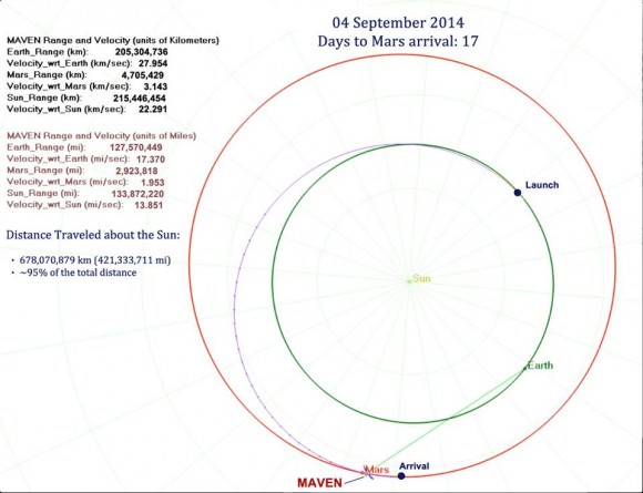
Maven spacecraft trajectory to Mars. Credit: NASA
Maven spacecraft trajectory to Mars on Sept. 4, 2014. Credit: NASA

The $671 Million MAVEN spacecraft’s goal is to study Mars upper atmosphere to explore how the Red Planet lost most of its atmosphere and water over billions of years and the transition from its ancient, water-covered past, to the cold, dry, dusty world that it has become today.

MAVEN soared to space over nine months ago on Nov. 18, 2013 following a flawless blastoff from Cape Canaveral Air Force Station’s Space Launch Complex 41 atop a powerful Atlas V rocket and thus began a 10 month interplanetary voyage from Earth to the Red Planet.

It is streaking to Mars along with ISRO’s MOM orbiter, which arrives a few days later on September 24, 2014.

So far it has traveled 95% of the distance to the Red Planet, amounting to over 678,070,879 km (421,332,902 mi).

As of Sept. 4, MAVEN was 205,304,736 km (127,570,449 miles) from Earth and 4,705,429 km (2,923,818 mi) from Mars. Its Earth-centered velocity is 27.95 km/s (17.37 mi/s or 62,532 mph) and Sun-centered velocity is 22.29 km/s (13.58 mi/s or 48,892 mph) as it moves on its heliocentric arc around the Sun.

One-way light time from MAVEN to Earth is 11 minutes and 24 seconds.

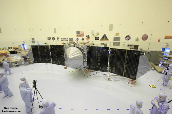
MAVEN is NASA’s next Mars orbiter and launched on Nov. 18, 2014 from Cape Canaveral, Florida. It will study the evolution of the Red Planet’s atmosphere and climate. Universe Today visited MAVEN inside the clean room at the Kennedy Space Center. With solar panels unfurled, this is exactly how MAVEN looks when flying through space and circling Mars and observing Comet Siding Spring. Credit: Ken Kremer/kenkremer.com

Stay tuned here for Ken’s continuing MAVEN, MOM, Rosetta, Opportunity, Curiosity, Mars rover and more Earth and planetary science and human spaceflight news.
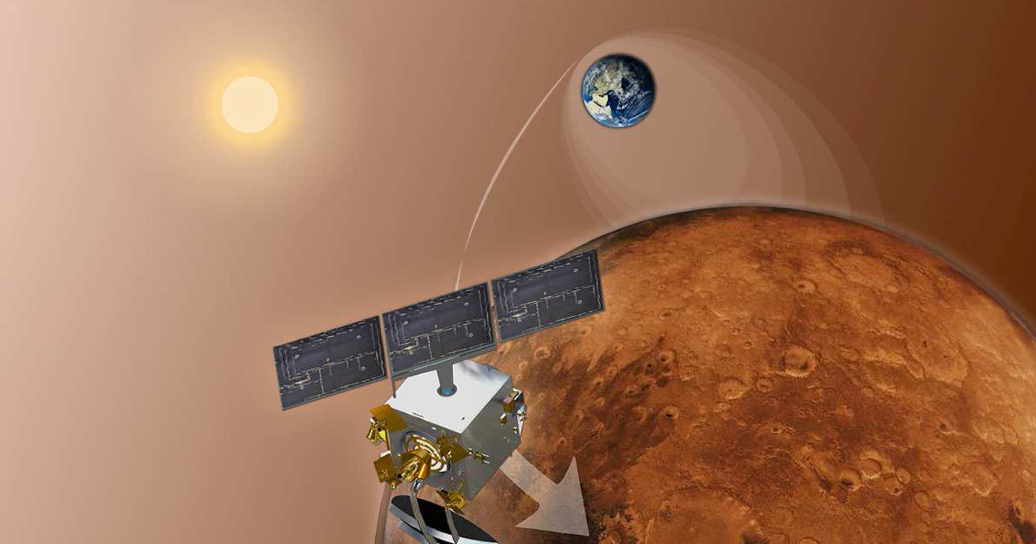
Ken Kremer

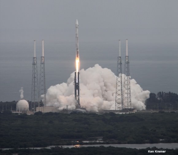
NASA’s Mars bound MAVEN spacecraft launches atop Atlas V booster at 1:28 p.m. EST from Space Launch Complex 41 at Cape Canaveral Air Force Station on Nov. 18, 2013. Image taken from the roof of the Vehicle Assembly Building (VAB) at NASA’s Kennedy Space Center.  Credit: Ken Kremer/kenkremer.com
NASA’s Mars bound MAVEN spacecraft launches atop Atlas V booster at 1:28 p.m. EST from Space Launch Complex 41 at Cape Canaveral Air Force Station on Nov. 18, 2013. Image taken from the roof of the Vehicle Assembly Building (VAB) at NASA’s Kennedy Space Center. Credit: Ken Kremer/kenkremer.com
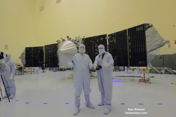
NASA’s MAVEN Mars orbiter, chief scientist Prof. Bruce Jakosky of CU-Boulder and Ken Kremer of Universe Today inside the clean room at the Kennedy Space Center on Sept. 27, 2013. MAVEN launches to Mars on Nov. 18, 2013 from Florida. Credit: Ken Kremer/kenkremer.com
NASA’s MAVEN Mars orbiter, chief scientist Prof. Bruce Jakosky of CU-Boulder and Ken Kremer of Universe Today inside the clean room at the Kennedy Space Center on Sept. 27, 2013. MAVEN launched to Mars on Nov. 18, 2013 from Florida. Credit: Ken Kremer/kenkremer.com