Anticipated Joint Experiment with Chandrayaan-1 and LRO Failed

India Moon Mission
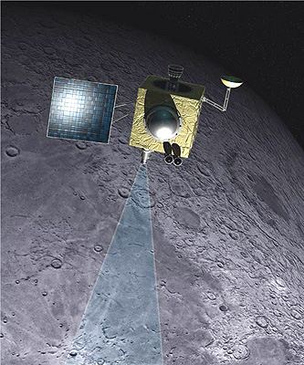
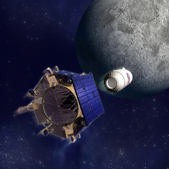
Artist concept of Chandrayaan-1 orbiting the moon. Credit: ISRO

[/caption]
A highly anticipated Bi-static radar experiment to look for possible water ice hiding in polar craters on the Moon failed due to the deterioration and eventual loss of the Chandrayaan-1 lunar orbiter. “Everything worked out as best as could be hoped, except for one thing,” said Paul Spudis, principal investigator for Chandrayaan-1’s radar instrument, Mini-SAR. “It turned out Chandrayaan-1 wasn’t pointed at the Moon when we were taking the data, but we didn’t know that at the time. So, the Bi-static attempt was a failure.” The experiment was attempted on August 20, and one week later the Chandrayaan-1 spacecraft failed completely due to overheating. The Indian Space Research Organization (ISRO) admitted they underestimated the amount of heat radiating from the Moon and didn’t have enough thermal protection on the spacecraft.

Spudis told Universe Today that both Chandrayaan-1 and the Lunar Reconnaissance Orbiter were in the right locations to do the experiment, but Chandrayaan-1 was pointed in the wrong direction. “We didn’t realize it, but the spacecraft was on its last legs at that point. When we commanded it to get into a certain attitude to do the experiment, it just wasn’t in that attitude, and we had no way of knowing it.”

The experiment required tricky maneuvers for both Chandrayaan-1 and LRO. The test was timed to coincide when both spacecraft were only 20 kilometers (12.4 miles) apart over Erlanger Crater near the Moon’s north pole. Chandrayaan-1’s radar was to transmit a signal to be reflected off the interior the crater to be picked up by LRO. Comparing the signal that would have bounced straight back to Chandrayaan-1 with the signal that bounced at a slight angle to LRO would have provided unique information about any water ice that may be present inside the crater.
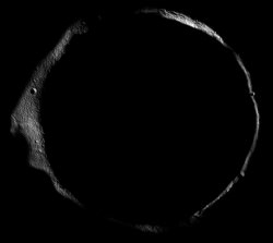
Erlanger crater imaged by LRO. Credit: NASA

Because of the loss of the star trackers earlier this year on Chandrayaan-1, Spudis said they weren’t certain during the test what direction the spacecraft was pointing. “We thought it was oriented in the right attitude, but it turned out it was not. So we didn’t send the radar beam into the crater like we had hoped, so therefore we didn’t get any echoes from it. It is disappointing, but that’s the space biz, that’s the way things go.”

Spudis said the international coordination required for the experiment between ISRO, JPL, NASA and the Applied Physics Lab worked exceptionally well. “Everyone did a great job and gave us great support on it. We came very close and the actual encounter was better than predicted. So everything worked except for the Chandrayaan-1 spacecraft.”

The teams were getting ready to try a repeat of the experiment, during the last weekend in August when Chandrayaan-1 quit communicating. “We were going to have another opportunity where the spacecraft were going to be close together over a different crater on the north pole,” Spudis said, “but then we lost the spacecraft on that Thursday. So that was disappointing. We gave it our best shot, but that’s the way it goes.”

But Spudis said he has his team have been busy focusing on studying and understanding the monostatic data they do have.

“We have some excellent quality data collected from mid- Feb to mid-April of this year,” he said. “We were able to get data from over 90% of both poles. We’re really just getting started analyzing it.”

There are missing pieces of data, especially directly at the poles because the instrument was a side-looking radar. The Mini-SAR always looked off nadir, off to one side of the ground track that is directly below the spacecraft. “So if you are in perfectly polar orbit, you will never image the poles because you are always looking off to the side,” Spudis explained. ” So we have these black zones around the poles. But we do have a lot of coverage around the poles of terrain that is in permanent darkness. We are studying that right now, and In fact, I am in the midst of writing up our first paper, and we’ll have some interesting results from that.”

Dr. Paul Spudis.
Dr. Paul Spudis.

Spudis said the loss of Chandrayaan-1 wasn’t totally unexpected due to the problems the spacecraft had been experiencing, but no one thought it would happen quite this quickly. “It was a little unexpected how rapidly it happened, how soon the end came,” he said. “Because the spacecraft had been having problems, we had been living with the various losses of capabilities, and we just kept soldiering through hoping that everything would work out. The timing was unfortunate.”

In addition the substantial amount of data received from Chandrayaan-1 data, Spudis is also looking to the data that will be coming from LRO. “LRO has a radar instrument that is a more advanced version than the one on Chandrayaan,” he said. “The difference is that there are two frequencies instead of one, and it has two resolutions – a normal resolution similar to India’s version on Chandrayaan-1 one, as well as a zoom version, a hi-res mode, with a factor of 6 or 7 better than the nominal mode.”

Spudis said LRO’s Mini-RF has been turned on during the LRO commissioning and so far it has been used to support the LCROSS impact. “They wanted to look at targets near the south pole, so we took some data for them. That data looks very interesting as well.”

For more information on Spudis’ work, check out his website.

Search for the Mars Polar Lander in New HiRISE Images

11 new HiRISE images are available to help search for the Mars Polar Lander. Credit: NASA/JPL

[/caption]

We had an enthusiastic response to an article we ran in July about searching through images from the HiRISE camera on the Mars Reconnaissance Orbiter to help find the ill-fated Mars Polar Lander. Now, Emily Lakdawalla at the Planetary Society Blog has sent out an alert that a dozen more images are available from the big release of images from HiRISE for additional searches for MPL, including the image above. See this page from the HiRISE site for a links to all the images. On this page, you’ll find an overview of the Mars Polar Lander, its disappearance, the search to find it, and why they want to find it. Emily also has a lengthy post with tips and instructions on how to search for particular objects in the HiRISE images. If you think you have found something of interest, post a comment on this page of the HiRISE Blog, or use this form to contact the HiRISE team. The UnmannedSpaceflight website has a thread discussing the search (serious searchers only).

Ok, phew, I think that’s all the links you’ll need! Let me know if I missed something….

Love Mars? Then This is For You

PDS Montage. Credit: HiRISE

[/caption]

We frequently ooh and aah over the images returned by the HiRISE camera from the Mars Reconnaissance Orbiter, and now there’s gonna be a whole lot of oohing and aahing going on. The HiRISE folks have just released more than 1,500 new observations of Mars for the Planetary Data System archive, showing a wide range of gullies, dunes, craters, geological layering and other features on the Red Planet. Take a gander at some of the highlights:

Colliding Sand Dunes in Aonia Terra.  Credit: NASA/JPL/University of Arizona
Colliding Sand Dunes in Aonia Terra. Credit: NASA/JPL/University of Arizona

This is one of my favorites, “Colliding Sand Dunes in Aonia Terra. See a “movie” of it here.
These images were taken during months of April through early August of this year. The camera team at the University of Arizona releases several featured images each week and periodically releases much larger sets of new images, such as the batch just posted.

See all the new images, available here.

Each full image from HiRISE covers a strip of Martian ground 6 kilometers (3.7 miles) wide, about two to four times that long, showing details as small as 1 meter, or yard, across.

Here’s another favorite; patterns in CO2 ice on Mars:

Patterns in carbon dioxide ice on Mars. Credit: NASA/JPL/University of Arizona

Meanwhile, engineers are still trying to determine what caused MRO to go into safe mode about a week ago. This has happened several times, and mission managers are intent on getting to the bottom of the problem.

To help in identifying a root cause in case of a recurrence, engineers have programmed the spacecraft to send back a higher rate of data, and to frequently record engineering data onto non-volatile memory. That large amount of data now being received could give an improved record of spacecraft events leading up to the latest reboot.

The Mars Reconnaissance Orbiter currently has normal power, temperatures and battery charge. It remains in proper sun-pointed attitude and in high-rate communication with Earth. Safe mode is a precautionary status that spacecraft are programmed to enter when they sense conditions for which they do not know a more specific response. While in this mode, a spacecraft suspends non-essential activities pending further instructions from ground controllers.

“The spacecraft is stable and our priority now is to carefully work our way to understanding this anomaly, with the intent of preventing recurrences,” Mars Reconnaissance Orbiter Project Manager Jim Erickson, at NASA’s Jet Propulsion Laboratory, Pasadena, Calif., said Friday.

For more information about the mission, visit the MRO website.

After Loss of Lunar Orbiter, India Looks to Mars Mission

India Moon Mission
Artist concept of Chandrayaan-1 orbiting the moon. Credit: ISRO

[/caption]
After giving up on re-establishing contact with the Chandrayaan-1 lunar orbiter, Indian Space Research Organization (ISRO) Chairman G. Madhavan Nair announced the space agency hopes to launch its first mission to Mars sometime between 2013 and 2015. Nair said the termination of Chandrayaan-1, although sad, is not a setback and India will move ahead with its plans for the Chandrayaan-2 mission to land an unmanned rover on the moon’s surface to prospect for chemicals, and in four to six years launch a robotic mission to Mars.


“We have given a call for proposal to different scientific communities,” Nair told reporters. “Depending on the type of experiments they propose, we will be able to plan the mission. The mission is at conceptual stage and will be taken up after Chandrayaan-2.”

On the decision to quickly pull the plug on Chandrayaan-1, Nair said, “There was no possibility of retrieving it. (But) it was a great success. We could collect a large volume of data, including more than 70,000 images of the moon. In that sense, 95 percent of the objective was completed.”

Contact with Chandrayaan-1 may have been lost because its antenna rotated out of direct contact with Earth, ISRO officials said. Earlier this year, the spacecraft lost both its primary and back-up star sensors, which use the positions of stars to orient the spacecraft.

The loss of Chandrayaan-1 comes less than a week after the spacecraft’s orbit was adjusted to team up with NASA’s Lunar Reconnaissance Orbiter for a Bi-static radar experiment. During the maneuver, Chandrayaan-1 fired its radar beam into Erlanger Crater on the moon’s north pole. Both spacecraft listened for echoes that might indicate the presence of water ice – a precious resource for future lunar explorers. The results of that experiment have not yet been released.

Chandrayaan-1 craft was designed to orbit the moon for two years, but lasted 315 days. It will take about 1,000 days until it crashes to the lunar surface and is being tracked by the U.S. and Russia, ISRO said.

The Chandrayaan I had 11 payloads, including a terrain-mapping camera designed to create a three-dimensional atlas of the moon. It is also carrying mapping instruments for the European Space Agency, radiation-measuring equipment for the Bulgarian Academy of Sciences and two devices for NASA, including the radar instrument to assess mineral composition and look for ice deposits. India launched its first rocket in 1963 and first satellite in 1975. The country’s satellite program is one of the largest communication systems in the world.

Sources: New Scientist, Xinhuanet

Radio Contact Lost With Chandrayaan-1

Artists impress of Chandrayaan-1 at the moon. Credit: ISRO

[/caption]
India’s lunar orbiter Chandrayaan-1 lost contact with ISRO’s ground station early on August 29. “We are not able to establish contact with the spacecraft. We are not getting the data, we are not able to send commands,” an ISRO official told the Press Trust of India. “In simple terms, the spacecraft has become dumb. It can’t speak.” The 11 scientific payloads onboard the orbiter had been operating normally, and the spacecraft was sending data during a planned sequence to its ground station when contact was lost. Officials are now analyzing data obtained, hoping to find any indications of what could have happened.

Chandrayaan 1 and NASA’s Lunar Reconnaissance Orbiter teamed up on August 20 to perform a bi-static radar experiment, and although no results have been released yet, the data had been successfully returned from the test.

Chandrayaan-1 was launched October 22, 2008, reaching the moon in early November. It has made over 3,000 orbits and its high-resolution cameras relayed over 70,000 digital images of the lunar surface, providing breathtaking views of mountains and craters, including those in the permanently shadowed area of the moon’s polar region.

The Times Now website is reporting that the mission is over, with a quote from Project Director of the Chandrayaan-1 mission, M Annadurai: “The mission is definitely over. We have lost contact with the spacecraft.”

He added “It has done its job technically…100 per cent. Scientifically also, it has done almost 90-95 percent of its job.”

But as of this writing it has only been about 18 hours since contact was lost. We’ll keep you posted on further news on Chandrayaan-1

Sources: PTI , Times Now

Hat tip to Svetoslav Alexandrov

Mars Reconnissance Orbiter Goes Into Safe Mode Again

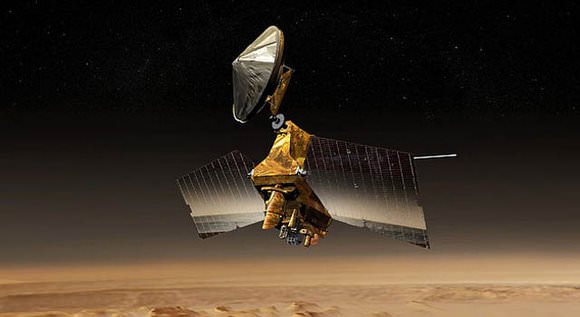
Artists concept of the Mars Reconnaisance Orbiter. Credit: NASA/JPL

[/caption]
NASA’s Mars Reconnaissance Orbiter put itself into a safe mode Wednesday morning, Aug. 26, for the fourth time this year. While in safe mode, the spacecraft can communicate normally with Earth, but aborts its scheduled activities, and awaits further instructions from ground controllers. “We hope to gain a better understanding of what is triggering these events and then have the spacecraft safely resume its study of Mars by next week,” said MRO Project Manager Jim Erickson.

Engineers have begun the process of diagnosing the problem prior to restoring the orbiter to normal science operations, a process expected to take several days. They will watch for engineering data from the spacecraft that might aid in identifying the cause of event and possibly of previous ones.

A possible cause for the frequent anomalies is cosmic ray hits. But the spacecraft has reacted differently with the various safe mode entries. The orbiter spontaneously rebooted its computer Wednesday, as it did in February and June, but did not switch to a redundant computer, as it did in early August.

To help in investigating a root cause of the three previous anomalies, engineers had programmed the spacecraft to frequently record engineering data onto non-volatile memory. That could give an improved record of spacecraft events leading up to the reboot.

MRO has been in Mars orbit since 2006, and has returned more data than all other current and past Mars missions combined.

Source: JPL

Mars Kicking Spirit When She’s Down

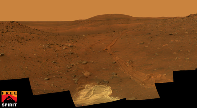
This full-circle view from the panoramic camera (Pancam) on NASA's Mars Exploration Rover Spirit shows the terrain surrounding the location called "Troy," where Spirit became embedded in soft soil during the spring of 2009. Credit: NASA/JPL

[/caption]
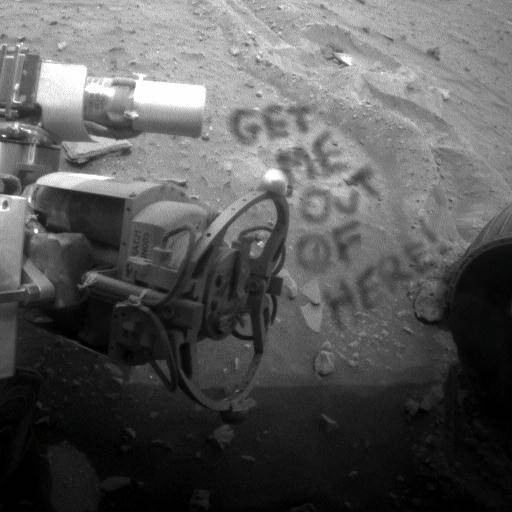
The Spirit rover has been stuck in loose soil on Mars for several months now, and just as the rover team is preparing to execute maneuvers to attempt to free Spirit, a dust storm hits. Is Mars an unforgiving planet or what? The amount of electricity generated by the solar panels on Spirit has been declining for the past several Martian days, or sols, because of the storm, and Spirit’s daily activities have been trimmed. Those watching over the rover are keeping an eye on weather reports from observations by NASA’s Mars Reconnaissance Orbiter. While the rover team at JPL are keeping their “spirits” up, a recent image from the rover indicates Spirit herself might be getting frustrated with her string of bad luck:

Get me out of here! Credit: NASA/JPL, image enhancement by Stuart Atkinson

Thanks to Stuart Atkinson from Cumbrian Sky for his image spoof!

Spirit’s solar panels generated 392 watt-hours during the mission’s Sol 2006 (Aug. 24, 2009), down from 744 watt-hours five sols earlier, but still generous compared with the 240 watt-hours per sol that was typical before a series of panel-cleaning events about four months ago.

“We expect that power will improve again as this storm passes, but we will continue to watch this vigilantly,” said JPL’s John Callas, project manager for Spirit and its twin, Opportunity. “Spirit remains power positive with healthy energy margins and charged batteries. The weather prediction from the Mars Color Imager team is that the storm is abating, but skies will remain dusty over Spirit for the next few sols.”

Recent images from the Mars Color Imager camera on Mars Reconnaissance Orbiter showed this regional storm becoming less extensive Monday even as it shifted southward so that its southern edge covered the Gusev Crater area where Spirit is working. Malin Space Science Systems in San Diego, which operates that camera, provides frequent weather updates to the rover team. Check out weekly weather reports here.

Meanwhile, in JPL’s In-Situ Instrument Laboratory, the rover team is continuing testing of strategies for getting Spirit out of a patch of soft soil where it is embedded on Mars. On Sol 2005 (Aug. 23, 2009) Spirit used its panoramic camera to examine the nature of how soil at the site has stuck to the rover’s middle wheels. The team has also used Spirit’s rock abrasion tool as a penetrometer to measure physical properties of the soil around Spirit by pressing into the soil with three different levels of force. The team is aiming to start sending drive commands to Spirit in September.

Source: JPL

LCROSS Anomaly Causes “Substantial” Fuel Loss

LCROSS on its way to impact. Credit: NASA

[/caption]
The operations team for the Lunar Crater Observation and Sensing Satellite (LCROSS) mission has discovered the spacecraft experienced an anomaly, causing it to use up a substantial amount of its fuel. According to spacecraft data, the LCROSS Internal Reference Unit (IRU) experienced a fault. The IRU is a sensor used by the spacecraft’s attitude control system (ACS) to determine the orientation and trajectory of the spacecraft. The anomaly caused the spacecraft ACS to switch to the Star Tracker Assembly for spacecraft positional information and caused the spacecraft’s thruster to fire excessively, consuming a substantial amount of fuel. Initial estimates, however, indicate that the spacecraft still contains sufficient fuel to complete the full mission.

LCROSS is scheduled to impact the lunar south pole in early October.

The team discovered the problem during a communications pass with the spacecraft on August 22, 2009. Mission operations declared a ‘spacecraft emergency’ and were allocated additional communications time on the Deep Space Network. The team conducted procedures to mitigate the problem and were able to restart the IRU and reduce fuel consumption to a nominal level. Automatic operations procedures also were implemented to minimize the possibility of another IRU anomaly from occurring while the spacecraft is out of contact with the ground.

Thankfully, since the re-start of the IRU, the spacecraft has not experienced any additional problems.

The team continues to actively assess and mitigate the situation and is in contact with the manufacturers of the IRU and star tracker to investigate the root cause of the problems. Mission managers remain optimistic the LCROSS mission can reach its successful conclusion with projected impact at the lunar south pole currently set for 4:30 a.m. PDT on Oct. 9, 2009.

LCROSS launched with the Lunar Reconnaisance Orbiter on June 18, 2009. The main LCROSS mission objective is to confirm the presence or absence of water ice in a permanently shadowed region near a lunar pole. Learn more about LCROSS and LRO here.

Source: SpaceRef

Latest LRO Image Solves Apollo 14 Mystery

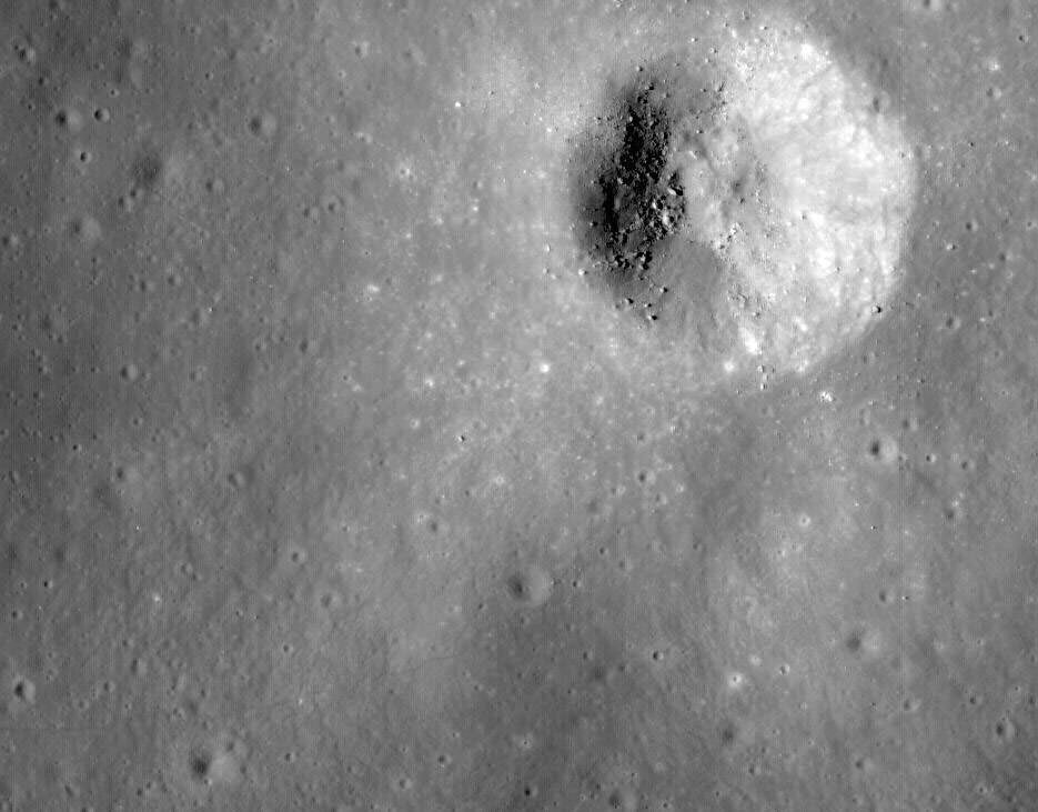
Cropped image of LRO's image from Apollo 14 landing site and Cone Crater. Tracks from the astronauts can be seen. Click for larger version.

During the second EVA of the Apollo 14 mission on the moon, astronauts Alan Shepard and Edgar Mitchell had a goal of hiking to the rim of nearby Cone Crater in the Fra Maura highlands. But the steep terrain made the going difficult, elevating the astronauts’ heart rates. Additionally, without landmarks it was difficult to judge distances. With the rolling terrain, filled with similar-looking ridges, Shepard and Mitchell couldn’t really tell if they were close to the rim or not.

Realizing time and available oxygen were getting short, Mission Control told the astronauts to head back to the Lunar Module, and although disappointed, the astronauts agreed. But how close did they actually come to the crater? No one knew for sure, until now.

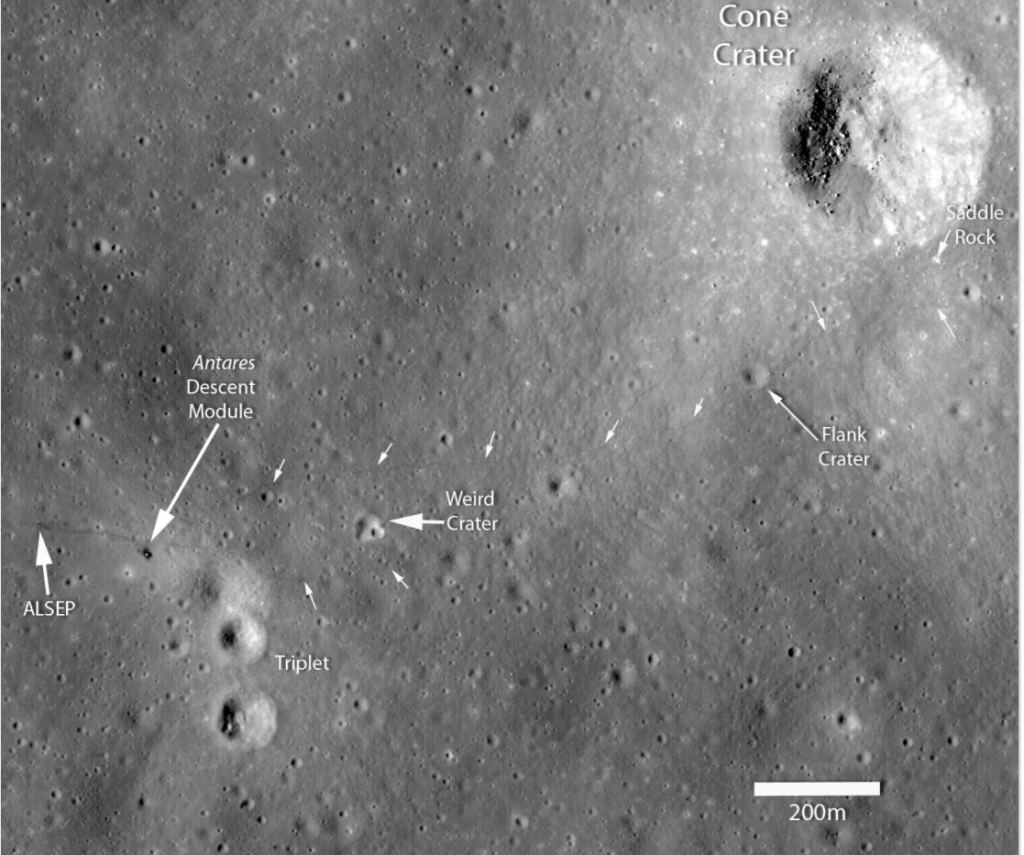
Annotated figure showing the positions of various landmarks surrounding the Apollo 14 landing site. The small white arrows highlight locations where the astronauts’ path can be clearly seen [NASA/GSFC/Arizona State University].

One of the latest images from the Lunar Reconnaissance Orbiter shows new details of the Apollo 14 landing site. If you look closely at the image above, visible are the tracks from the astronauts steps and their three-wheeled MET cart, and you can clearly follow the trail of the astronauts on their “radial traverse.” Click the image for larger version if you’re having trouble seeing the tracks. Their tracks stop just 30 meters short of the rim, near a dark spot just to the lower left of the crater, which might be Saddle Rock, shown in the image below. Shepard and Mitchell never realized just how close they really were.

This photograph shows Saddle Rock, the largest boulder seen on this mission. Named for its shape, Saddle Rock is 4.5 meters across. Credit: NASA

On the LROC (Lunar Reconnaissance Orbiter Camera) website, Samuel Lawrence notes that more and different detail is visible on this image as opposed to the initial images released prior to the Apollo 11 anniversary in July because the lighting is different. “This time the Sun is 24 degrees higher above the horizon providing a clearer view with fewer shadows. Albedo contrasts are greater, and more clearly show soil disturbances from landing, astronaut surface operations, and blast off.”

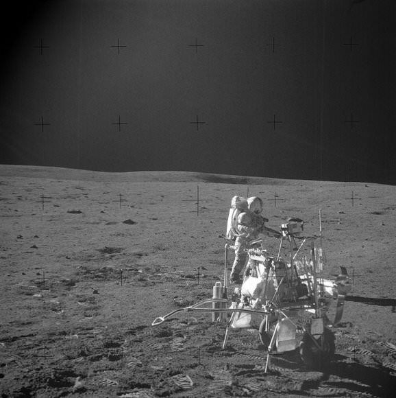
The MET cart from Apollo 14. Credit: NASA

Lawrence notes how the term “radial traverse” does not quite do the crew of Apollo 14 justice.

“Their journey sounds like a stroll in the park, however the reality is quite the contrary. The hike up Cone crater was quite challenging. For the first time, astronauts traveled out of the sight of their lunar module while hiking uphill over 1400 meters with only a poor map, dragging the tool cart (MET), and wearing their bulky spacesuits. It was an amazing feat that the two astronauts made it to the top of Cone ridge and acquired all their samples. They ended up about 30 meters shy of peering into Cone crater itself, surely a disappointment at the time, but absolutely no reflection on the success of the traverse and the scientific results gleaned after the mission.”

Source: LROC

2000 Sols on Mars

2000 Sols on Mars. Credit: Astro0 in Space

[/caption]
Another milestone for the Mars Exploration Rovers: Spirit has been operating on Mars for 2000 sols, or Martian days. Who would have ever thought the rovers would last this long? But here they are, still going, um, pretty strong. Even though she’s got plenty of electrical power, Spirit is currently stuck in loose soil at her location, called Troy. But engineers are working hard to figure out how to set her free. Check out the latest on the efforts at the Free Spirit website.

To celebrate Spirit’s milestone, Unmanned Spaceflight’s Astro0 has put together a Sol 2000 poster over at his website, Astro0 in Space. It’s gorgeous, and includes a new poem by my pal Stuart Atkinson, so check it out!