Test-Bed Rover is Now Stuck — Which is a Good Thing!

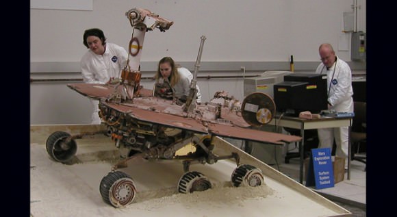
With a slope of about 10 degrees and a pointy rock under the test rover's belly, this sandbox setup at NASA's Jet Propulsion Laboratory, Pasadena, Calif., is ready for engineers to use the test rover to assess possible moves for getting Mars rover Spirit out of a patch of loose Martian soil. Credit: JPL

[/caption]
Engineers at the Jet Propulsion Laboratory have intentionally driven their engineering rover into soft soil in a sandbox testbed, to simulate how the Spirit rover is stuck on Mars. And they did a good job of it, too, as the test rover, called SSTB1, is stuck, as well, with its wheels spinning and going nowhere. The science team has confirmed a rock on Mars, underneath Spirit is touching the underside of the rover, so engineers have placed a similar looking rock in the test sandbox, as seen above.

“We want to experiment with different extraction techniques down here on Earth before we actually do them for real on Mars,” said John Callas, project manager for the Mars rovers. “Our expectation is that it will some time to get Spirit out, so we will be able to get a better feel for that here in this facility to see how well the techniques work and how long it will take for them to work.”

The rover team spent several days of preparing a sloped area of soft, fine soil to simulate Spirit’s current sandtrap on Mars. On June 30 they maneuvered the test rover around, driving the wheels to the loose soil where the rover would sink and slide to the side, with a slope of about 10 degrees, as engineers believe Spirit has done on Mars.

You can follow the work being done to free Spirit from her predicament at the Free Spirit website. JPL regularly posts updates and videos showing what the rover teams are doing, and currently you can see a movie of how the test rover was driven in the sandbox to get stuck.
A test rover rolls off a plywood surface into a prepared bed of soft soil.  Credit: JPL
A test rover rolls off a plywood surface into a prepared bed of soft soil. Credit: JPL

There are actually two test vehicles, and the folks at UnmannedSpaceflight.com have a page explaining the differences, as well as other FAQs about the attempts to free Spirit. The one being use for this current test, SSTB1 is a full size replica of the MER vehicles, but it has a few differences such as no solar panels, and a few other minor missing parts. It has the same mass as the ones on Mars, which means it has a higher weight on Earth than the MERs have on Mars.

The other test rover, SSTB Lite, is a stripped down vehicle with same wheel size, actuators and suspension system, but has other major components missing which gives it a weight on Earth that is similar to the weight of MER on Mars. However, when the Opportunity rover was stuck a couple of years in the Purgatory dune, engineers found that SSTB1 behaved more similarly to the MER vehicles, possibly because both the SSTB1 and the soil were subject to the same gravity vector.
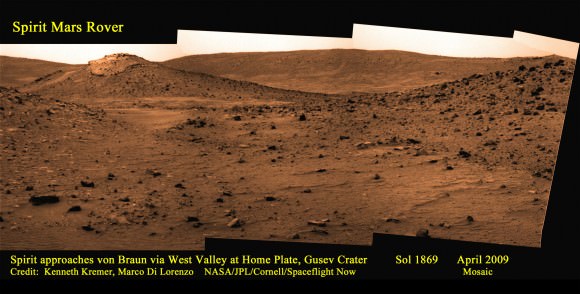
Mosaic of the area around Home Plate where Spirit remains stuck was made especially for Spaceflight Now (Used by permission).  Credit: Kenneth Kremer, Marco DiLorenzo, NASA/JPL/Cornell/Spaceflight Now.  Click for larger image.
Mosaic of the area around Home Plate where Spirit remains stuck was made especially for Spaceflight Now (Used by permission). Credit: Kenneth Kremer, Marco DiLorenzo, NASA/JPL/Cornell/Spaceflight Now. Click for larger image.

So, just where is Spirit on Mars? Take a look at this great image created by Ken Kremer and Marco DeLorenzo of UnmannedSpaceflight.com, showing Spirit’s current location. It shows smooth area in the foreground, that concealed slippery water related sulfate material where rover became stuck. Once free, Spirit will drive to area near the unusually capped hill ahead designated Von Braun to sample water related evidence there. Let’s hope the engineer’s work here on Earth will “Free Spirit” and enable explorations of Von Braun, and beyond.

Caption for mosaic above: Mosaic of the area around Home Plate where Spirit remains stuck was made especially for Spaceflight Now (Used by permission). Credit: Kenneth Kremer, Marco DiLorenzo, NASA/JPL/Cornell/Spaceflight Now. Click the picture for a larger image.

Sources: “Free Spirit” website, Unmanned Spaceflight, Spaceflightnow.com

Watch Live Webcast of Ulysses Spacecraft Switch-off

Artist impression of the Ulysses spacecraft. Credit: NASA/ESA

[/caption]
UPDATE: Use this link to watch the webcast (the other one isn’t working very well!)

It’s the spacecraft that just won’t quit. We ran a story about a year ago that the Ulysses spacecraft was dying of natural causes (running out of power to keep the spacecraft warm and functional) and its mission would likely end by July 1, 2008. The thing is, the spacecraft just kept hanging on…and hanging on….and hanging on. But now, after 18.6 years in space and defying several earlier expectations of its demise, Ulysses will finally be switched off. You can watch a live webcast of the final communication with the spacecraft, which will occur on June 30, 2009, starting at 15:35 GMT and go until 20:20 GMT.

“Ulysses has taught us far more than we ever expected about the Sun and the way it interacts with the space surrounding it,” said Richard Marsden, ESA’s Ulysses Project Scientist and Mission Manager.

Ulysses was the first spacecraft to survey the environment in space above and below the poles of the Sun in the four dimensions of space and time. Among many other ground-breaking results, the mission showed that the Sun’s magnetic field is carried into the Solar System in a more complicated manner than previously believed. Particles expelled by the Sun from low latitudes can climb up to high latitudes and vice versa, even unexpectedly finding their way down to planets.

And as a eulogy to the Ulysses spacecraft, here’s the last lines from the poem “Ulysses” by English poet Alfred, Lord Tennyson:

“Death closes all; but something ere the end,
Some work of noble note, may yet be done…
‘Tis not too late to seek a newer world…
To sail beyond the sunset.”

Link for webcast.

Spirit Rover Begins Making Night Sky Observations

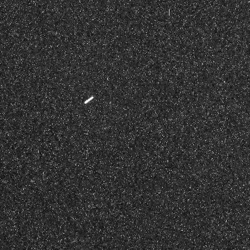
The bright streak is the star Canopus. Credit: NASA/JPL

[/caption]

When your rover has abundant energy but can’t go anywhere, what’s a scientist to do? How about making observations of the evening and night skies on Mars? With the benefit of a boost in electrical power from a wind gust cleaning off her solar panels, the Spirit rover has more energy available than she’s had for a couple of years. But unfortunately, Spirit is stuck in a patch of loose soil in the Home Plate region on Mars. While the engineers at JPL work hard at figuring out how to “Free Spirit” (see the new website dedicated to their efforts) scientists are making observations of her surroundings to aid in the effort to get her out. But there’s also enough power to do additional observations, and astronomy was a logical choice. “Certainly, a month or more ago, no one was considering astronomy with the rovers,” said Mark Lemmon, planetary scientist at Texas A&M University and member of the rover team. “We thought that was done. With the dust cleanings, though, everyone thinks it is better to use the new found energy on night time science than to just burn it with heaters.” Besides, Lemmon added, using all the energy in the daytime might lead to overheating.

The image above was taken on Spirit’s sol 1943 (June 22 on Earth)showing the night sky above her location.

But most of the “stars” in this raw image are not really stars, just hot pixels. “We use long and multiple exposures to make stars stand out,” Lemmon told Universe Today. “We can only see bright stars, looking through the dust, but can pick out most of the major stars in Orion for instance.”

But a star is visible in this image. “That streak in the 1943 images is the bright star Canopus,” said Jim Bell, planetary scientist at Cornell University and lead for the rovers’ Pancam team. “We’re monitoring stars to search for evidence of night-time clouds, fog, and hazes.  We’re also occasionally trying to image Earth and Venus as they set in the west after sunset.  We’ve had some success, but the twilight sky is so bright we’re still working on tweaking the exposure times.”

Of course, this isn’t the first time Spirit has done astronomy on Mars. She also made night sky observations back in 2005. In an article Bell wrote for Sky and Telescope in 2006 he described Spirit’s astronomy as “stone-knives and bear-skins backyard astronomy–but from Mars!” And certainly, this is exciting to have an additional opportunity to make astronomical observations from the surface of another world.

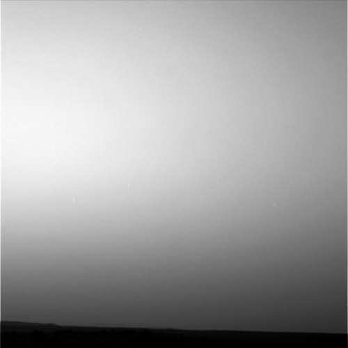
Spirit's twilight observations from sol 1947. Credit: NASA/JPL


Bell added that the current astronomy campaign with Spirit has many similarities with the one four years ago, and Lemmon said they are focusing on a few different goals for looking at the twilight and night skies.

“The Canopus images may become a regular occurrence, as a way to monitor dust and/or ice in the sky at night–much as we use Sun images in the day,” Lemmon said. “For something like that, we can pick an aim (Canopus, Orion, etc.) and choose filters. We might use color filters to look for any differences that show up, or the clear filter for the most sensitive measurement. Star exposures can go up to 5.5 minutes (compare to 0.1-0.5 sec for a normal day image). We cannot track stars, so they trail after 10 seconds or so–as you see Canopus doing. In longer exposures, hot pixels and cosmic rays show up as points or cluster of light.”

Lemmon said attempting to image Earth and Venus has been challenging. “We’ve imaged both before, farther from the Sun. They are in the twilight, limiting the exposure we can use, and they are in a “bright” part of the sky.”

Lemmon added his personal favorite right now is actually the twilight imaging — not looking at stars but at how fast the twilight glow fades after sunset. “That is proving to be quite helpful in terms of understanding the distribution of dust in the atmosphere –which is closely tied to how weather works on Mars,” he said.

In 2005, the Pancam team was able to capture images of Mars’ two moons, Phobos and Deimos. “They are much brighter and let us use more filters if desired. We may pick this up again. I’m a fan of eclipse imaging, so we would need several quick images to see how fast the moon fades as sunlight is blocked by dust around Mars.”

The moons should start becoming more visible soon, and Lemmon said they will continue to take more images of Canopus and maybe other star fields. The team is not specifically looking for meteors or the orbiters around Mars, but there’s always the prospect of something fascinating showing up on future images.

“We’ve taken some recent images I hope will have new, interesting things in them,” Lemmon said. “But they are still on board the rover so we’ll have to wait and see what they show later.”

Stay tuned!

Link to Spirit’s raw images.

Webpage on Spirit’s 2005 astronomical imaging.

Sources: email exchanges with Mark Lemmon and Jim Bell

LRO Successfully In Lunar Orbit; LCROSS Provides Flyby Video

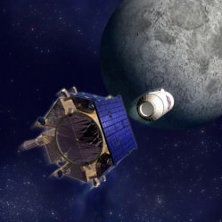
LCROSS flyby video capture. Credit: NASA

[/caption]
The Lunar Reconnaissance Orbiter fired its braking thrusters for 40 minutes early today, successfully inserting the spacecraft into orbit around the Moon. Over the next several days, LRO’s instruments will be turned on and its orbit will be fine-tuned. Then LRO will begin its primary mission of mapping the lunar surface to find future landing sites and searching for resources that would make possible a permanent human presence on the moon. Also, early Tuesday, the companion mission Lunar Crater Observation and Sensing Satellite (LCROSS) sent back live video as it flew 9,000 km above the Moon, as it enters its elongated Earth orbit, which will bring it on course to impact the Moon’s south pole in October.

The two spacecraft reached the Moon four-and-a-half days after launch. LRO’s rocket firing began around 9:20 GMT (5:47 a.m. EDT) and ended at 10:27 GME (6:27 a.m. EDT), putting the spacecraft into an orbit tilted 30 degrees from the moon’s poles with a low point of 218 km (136 miles) and a high point of 3,000 km (1,926 miles). Over the next five days, additional rocket firings will put the spacecraft into the correct orbit for making its observations for the prime mission, which lasts a year — a polar orbit of about 31 miles, or 50 kilometers, the closest any spacecraft has orbited the moon.

Meanwhile, at 12:20 GMT (8:20 EDT) on Tuesday, LCROSS made a relatively close flyby of the Moon, sending back live streaming video. Watch the replay here.

LCROSS on its way to impact. Credit: NASA

LCROSS is now in its “cruise phase” and will be monitored by the mission operations team. During the flyby, the science team was able to obtain the data needed to focus and adjust the cameras and spectrometers correctly for impact.

LCROSS will never actually be lunar orbit, but is working its way to an elongated Earth orbit which will eventually bring it to the correct orientation for meeting up with the south pole of the Moon later this year. LCROSS will search for water ice on the moon by sending the spent upper-stage Centaur rocket to impact part of a polar crater in permanent shadows. The LCROSS spacecraft will fly into the plume of dust left by the impact and measure the properties before also colliding with the lunar surface.

Watch Live Streaming Video From LCROSS Lunar Swingby Tuesday

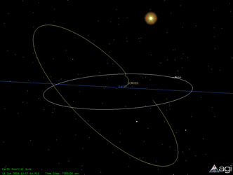
Graphic showing LCROSS's orbit. Credit: NASA

[/caption]
On Tuesday morning, the LCROSS spacecraft will fly by the Moon only 9,000 km above the lunar surface and send back live streaming video for about an hour. This relatively close encounter with the Moon, will help put LCROSS in the correct position to impact the lunar surface in October. LCROSS will never actually be lunar orbit, but is working its way to an elongated Earth orbit which will eventually bring it to the correct orientation for meeting up with the south pole of the Moon later this year. LCROSS will search for water ice on the moon by sending the spent upper-stage Centaur rocket to impact part of a polar crater in permanent shadows. The LCROSS spacecraft will fly into the plume of dust left by the impact and measure the properties before also colliding with the lunar surface. Live video streaming of the flyby begins at approximately 12:20 GMT (8:20 EDT) on Tuesday, June 23, 2009. Click here to watch.

The LCROSS instrumentation will send back data to Earth for approximately one hour. The first 30 minutes will contain a view of the lunar surface from an altitude of approximately 9,000 km. The video feed is set to display one frame per second. During the latter 30 minutes, the spacecraft will perform multiple scans of the moon’s horizon to calibrate its sensors. During this latter half hour, the video image will update only occasionally. The 3D visualization stream will show the spacecraft position and attitude throughout the swingby.

Watch this video of the LCROSS mission overview.

Source: LCROSS

LRO/LCROSS Ready for Launch to the Moon

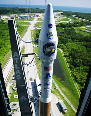
The Atlas V with LRO and LCROSS at the pad. Credit: NASA

[/caption]
NASA is going back to the Moon today! The Lunar Reconnaissance Orbiter (LRO) and a piggyback mission called the Lunar Crater Observation and Sensing Satellite (LCROSS) are at the launch pad, ready to blast off on an Atlas V today (Thursday June 18), with launch windows at 5:12 p.m., 5:22 p.m. or 5:32 p.m. EDT. (9:12, 9:22 or 9:32 GMT). The dual mission will provide detailed lunar maps to aid in returning humans to the moon, while searching for water ice in permanently shaded craters at the moon’s poles.

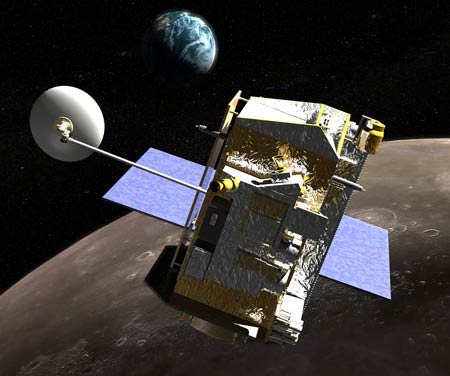
LRO is scheduled for a one-year prime mission, exploring the moon from a polar orbit of about 31 miles, or 50 kilometers, the closest any spacecraft has orbited the moon. Its primary objective is to conduct investigations to prepare for future explorations of the moon.

“LRO will circle the moon every two hours,” Craig Tooley, LRO project manager explained at a press briefing earlier this week. “As moon rotates, LRO will be able to see the entire surface, so every month, we will map the entire surface of moon. There will be gaps in our measurements because the view of the instruments are very narrow beneath the satellite ground track. Over the course of an entire year, we can fill in these gaps to have a global measurement of the moon and a new set of data, a new atlas so to speak showing temperature, minerals, images and other data.”

Artist concept of LRO in lunar orbit. Credit: NASA

Tooley said that the Apollo missions accepted the risk of not knowing details of the landing sites. “They had safe landings, but we want to return to moon with repeated landings and have a higher degree of safety.”

LRO will be able to look at the distribution of rocks, boulders, and craters, with its 50 cm spatial resolution camera. “We’ll be able to see small boulders and know where it is safe to land,” said Rich Vondrak, project scientist. “NASA has identified fifty high priority sites that are potential landing sites for astronauts.”

LRO has a Narrow Angle Camera (NAC) and a Wide Angle Camera (WAC). NAC is dedicated to high resolution, and Vondrak said the high priority regions will be mapped in high res the first year, and they are working with science community for areas to study during an extended mission.

The Lunar Oribter Laser Altimeter (LOLA) will provide a high resolution 3-D relief map of moon. “LOLA resolution will be 10 times better than what we currently have,” said Vondrak. “We’re looking forward to mapping Aiken Basin, a huge depression, very carefully, and the polar regions are of high interest. We’ll have new eyes on the moon to get new views to prepare for future exploration of the moon.”

Regions near the pole have nearly continuous sunlight, which could be a source of warmth and power for future explorers. There are also regions inside polar craters that are continuously dark and very cold, and previous missions have found evidence of hydrogen, which scientists expect to be associated with water ice, a potential resource for future explorers.

“We’ll do the best possible attempt of determining the characteristic of the lunar surface from orbit, but to really understand the water content of the surface, you would like to land there,” said Vondrak. “We are fortunate that LRO will carry a companion mission, LCROSS, to seek water on the moon.”

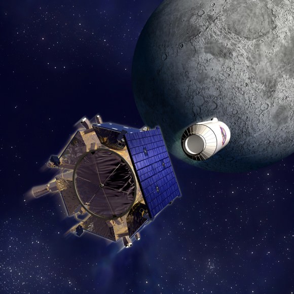
Artist concept of LCROSS and Centaur stage heading for impact. Credit: NASA

LCROSS will search for water ice on the moon by sending the spent upper-stage Centaur rocket to impact part of a polar crater in permanent shadows. LCROSS will fly into the plume of dust left by the impact and measure the properties before also colliding with the lunar surface.

“LCROSS will shepherd the Centaur to the precise orbit, and accelerate it into the moon,” said LCROSS project scientist Tony Colaprete. “The two will separate, with LCROSS following the Centaur by four minutes, taking live “bent pipe” meausrments, sendin back live video (which will be shown live via webcast) taking measurements of the lunar regolith characteristics, looking for lunar water vapor or ice characteristics, then impacting the lunar surface itself. LCROSS will be a smashing success.”

The impact will take place about 100 days after launch, and the science team hopes to recruit amateur astronomers and students to help watch the impact from Earth. “This should be very engaging for the public, and their observations will help us, too,” said Colaprete.

If launch slips to Friday, June 19, the launch opportunities would be 6:41 p.m., 6:51 p.m. and 7:01 p.m EDT (10:41, 10;51 and 11:01 GMT).

Several videos about LRO and LCROSS.

Follow LRO’s Launch Blog.

Watch KSC video feeds of launch prep and launch.

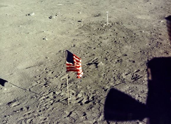
Follow Apollo Mission “Tweets,” 40 Years Later

Credit: NASA

[/caption]

This is just cool.

Nature, the publishing group, is mixing the old with the new by “tweeting” the Apollo 11 moon mission as it happened — 40 years later. Followers on Twitter will be able to read about technical milestones, political challenges, and related events in the space race starting today, just over a month before the 40th anniversary of the first lunar landing.

Apollo 11’s Twitter profile is here — and since the announcement this morning, already boasts 110 followers. The tweets will chronicle the Apollo 11 crew’s journey to the moon and back, and taper off during the weeks following the mission to give followers the context surrounding the moon mission and its implications for science and the wider world.

Source: Nature News. More information is available in an accompanying blog.

More Photos From the Lunar Time Machine

Lunar South pole 1967. Credit: LOIRP and MoonViews.com

[/caption]
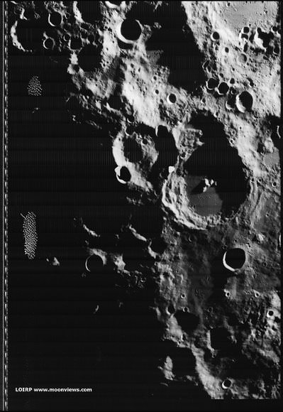
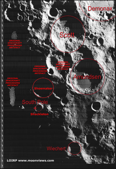
More images have been released by the Lunar Orbiter Imagery Recovery Project (LOIRP), the endeavor that has been called a “time machine” by team member Keith Cowing of NASA Watch. In 1966 and 1967, NASA sent five Lunar Orbiter missions to photograph the lunar surface to prepare for the Apollo missions to land humans on moon. Data were recorded on large magnetic tapes, and a special machine was needed to just to view the images. The LOIRP team is working on digitizing the data, and restoring the images to their full resolution. These images are especially timely, given the upcoming launch of the Lunar Reconnaissance Orbiter, hopefully this week. NASA can compare detailed high-resolution images from 1966 to the present and see what changes occurred in 40-plus years. “What this gives you is literally before and after photos,” Cowing said.

The above image was taken by Lunar Orbiter IV in May 1967 and shows the south pole of the Moon. This image shows the region without labels, and below, the image shows major features plus notation regarding processing artifacts from the spacecraft’s film processing system. The moon’s south pole is located near the rim of Shackleton Crater. The moon’s polar regions are currently of great interest as the Lunar CRater Observation and Sensing Satellite (LCROSS) will be targeted to impact at the moon’s south pole, to occur in October if LRO/LCROSS launches this week.

Lunar south pole, annotated. Credit: LOIRP and MoonViews.com


Apollo 12 site annotated. Credit: LOIRP and MoonViews.com

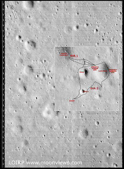
This image LO3-154-H was taken by Lunar Orbiter III on 20 February 1967 and shows the landing site for both Surveyor III, which landed on April 20, 1967 and Apollo 12, which landed on November 19, 1969. The annotations show major features plus EVA routes taken by the astronauts Pete Conrad and Allan Bean.

For more images and information see the LOIRP website, Moon Views.

LRO/LCROSS Gives Up Launch Date for STS-127

LRO on the launchpad. Credit: NASA

It’s a crowded dance floor and someone had to step aside. Because of Saturday’s launch delay for STS-127, the shuttle and the upcoming dual mission to the moon — the Lunar Reconnaissance Orbiter (LRO) and Crater Observation and Sensing Satellite (LCROSS) — were both vying to launch from Kennedy Space Center on the same day, which is not a possibility (usually there needs to be at least 48 hours between launches as the Air Force’s Eastern Range that monitors needs that amount of time to reconfigure the systems.) At a press conference today, NASA launch manager at KSC, Chuck Dovale announced LRO/LRCROSS will give up their originally schedule launch date of June 17 so that the shuttle can go. “We are relinquishing the June 17 date to the shuttle,” he said. “However, we will maintain June 18 as the earliest possible date for LRO/LCROSS. We will monitor the shuttle’s progress, and if they were to scrub the launch for any reason before midnight on the 16th, we can still maintain launch on the 18th.” But there’s a lot that has to go right for the optimum and hoped for launch schedules to happen.
Continue reading “LRO/LCROSS Gives Up Launch Date for STS-127”

Kaguya Will Impact the Moon on June 10

Lunar map showing Kaguya impact site. Credit: JAXA

[/caption]
The Japanese lunar orbiter Kaguya will end its two-year mission with a controlled impact on the Moon’s surface on June 10th at 18:30 Universal Time. The impact location is near the southeast limb at 80ºE, 63ºS. If you live in Asia and Australia, you may have the opportunity to observe the impact event, and the Japanese Space Agency –JAXA – wants to hear from you if you plan on watching for the impact. The event may be visible with a bright flash or plume. JAXA is making available precise information on the projected time and location of the event. If you are interested in observing the impact, contact JAXA at [email protected] and provide your name, location, and planned observation method.

For more information about the event, see this article on Lunar Photo of the Day.

Here’s JAXA’s page on the mission.

One of the visual highlights of the Kaguya mission was a high definition “Earthrise” movie: