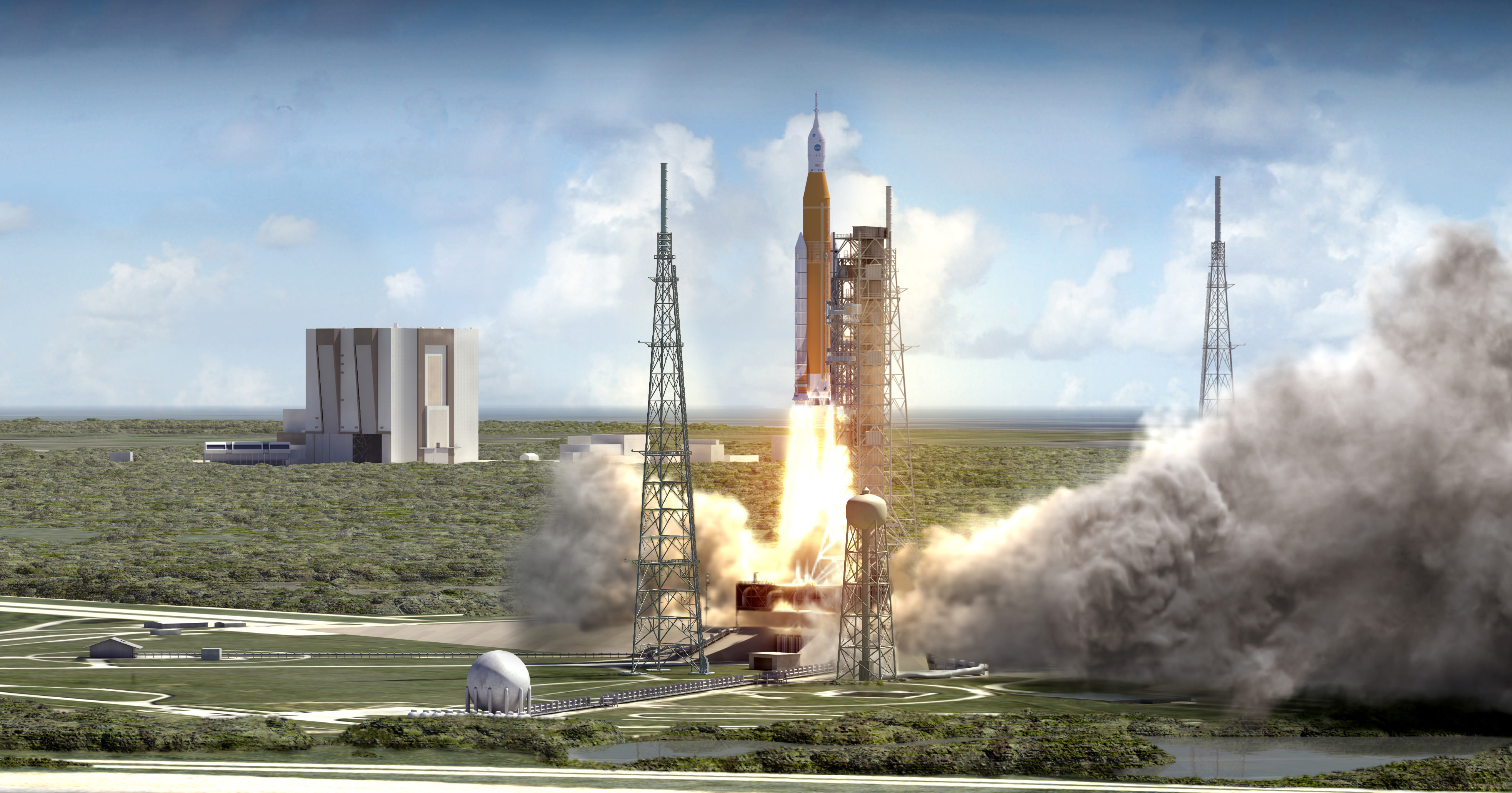
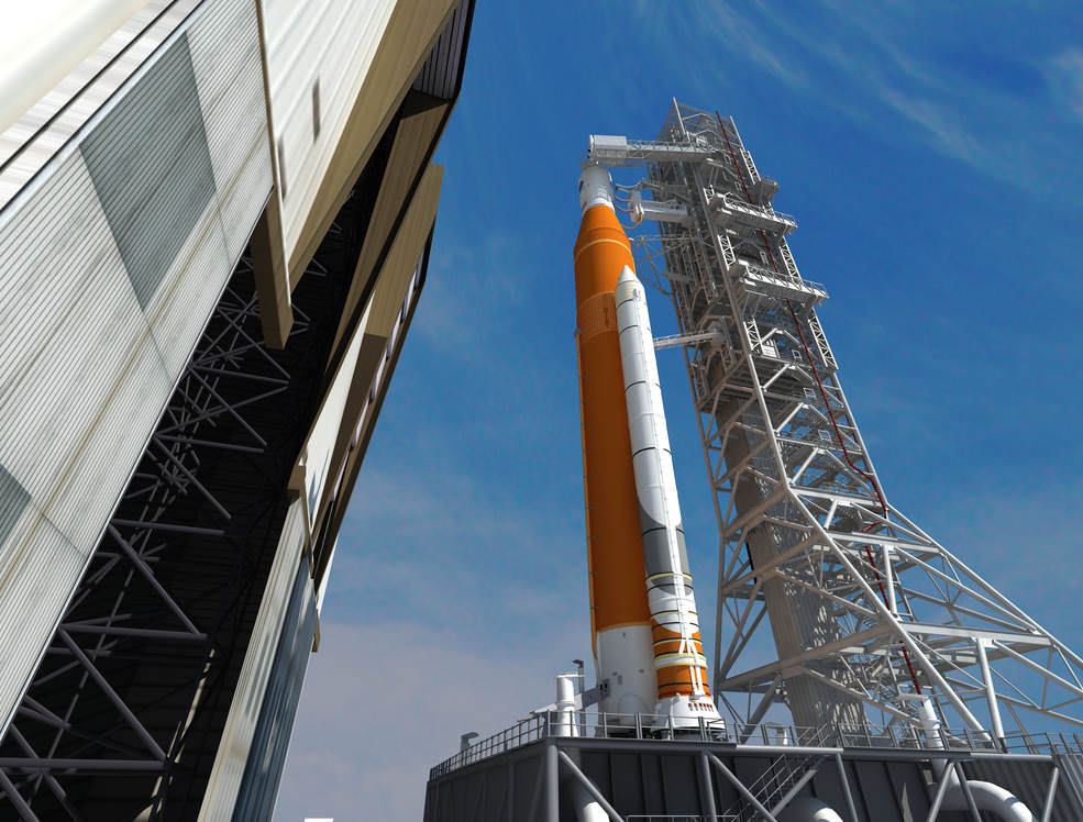
NASA’s Space Launch System (SLS) blasts off from launch pad 39B at the Kennedy Space Center in this artist rendering showing a view of the liftoff of the Block 1 70-metric-ton (77-ton) crew vehicle configuration. Credit: NASA/MSFC
NASA’s Space Launch System (SLS) blasts off from launch pad 39B at the Kennedy Space Center in this artist rendering showing a view of the liftoff of the Block 1 70-metric-ton (77-ton) crew vehicle configuration. Credit: NASA/MSFC
KENNEDY SPACE CENTER, FL – In a potentially major change in direction for NASA’s human spaceflight architecture, the agency is officially studying the possibility of adding a crew of astronauts to the first flight of the Orion deep space crew capsule and the heavy lift Space Launch System (SLS) rocket currently in development, announced Acting NASA Administrator Robert Lightfoot.
Lightfoot made the announcement in a speech to the Space Launch System/Orion Suppliers Conference in Washington, D.C. as well as an agency wide memo circulated to NASA employees on Wednesday, Feb. 15.
The move, if implemented, for the first joint SLS/Orion flight on Exploration Mission-1 (EM-1) would advance the date for sending American astronauts back to the Moon by several years – from the next decade into this decade.
Lightfoot has directed Bill Gerstenmaier, associate administrator for the Human Exploration and Operations Mission Directorate, to start detailed studies of what it would take to host astronauts inside the Orion EM-1 crew capsule.
“I have asked Bill Gerstenmaier to initiate a study to assess the feasibility of adding a crew to Exploration Mission-1, the first integrated flight of SLS and Orion,” Lightfoot said.
NASA’s current plans call for the unmanned blastoff of Orion EM-1 on the SLS-1 rocket later next year on the first test flight – roughly in the September to November timeframe from Launch Complex 39B at the Kennedy Space Center.
“The study will examine the opportunities it could present to accelerate the effort of the first crewed flight and what it would take to accomplish that first step of pushing humans farther into space,” NASA officials added in a statement.
But because of all the extra work required to upgrade a host of systems for both Orion and SLS for humans ahead of schedule, liftoff of that inaugural mission would have to slip by at least a year or more.
“I know the challenges associated with such a proposition, like reviewing the technical feasibility, additional resources needed, and clearly the extra work would require a different launch date” Lighfoot elaborated.
“That said, I also want to hear about the opportunities it could present to accelerate the effort of the first crewed flight and what it would take to accomplish that first step of pushing humans farther into space.”
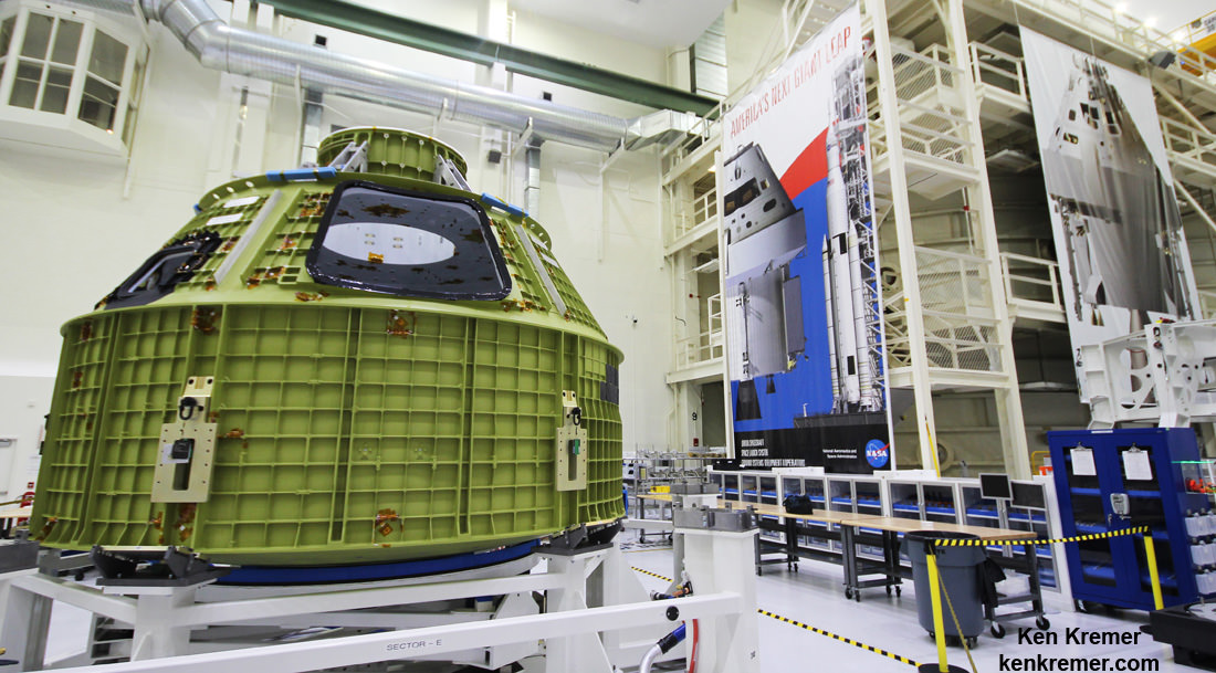
Orion crew module pressure vessel for NASA’s Exploration Mission-1 (EM-1) is unveiled for the first time on Feb. 3, 2016 after arrival at the agency’s Kennedy Space Center (KSC) in Florida. It is secured for processing in a test stand called the birdcage in the high bay inside the Neil Armstrong Operations and Checkout (O&C) Building at KSC. Launch to the Moon is slated in 2018 atop the SLS rocket. Credit: Ken Kremer/kenkremer.com
The Orion EM-1 capsule is currently being manufactured at the Kennedy Space Center.
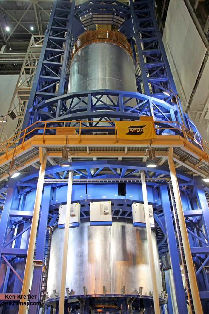
Components of the SLS-1 rocket are being manufactured at NASA’s Michoud Assembly Facility and elsewhere around the country by numerous suppliers.
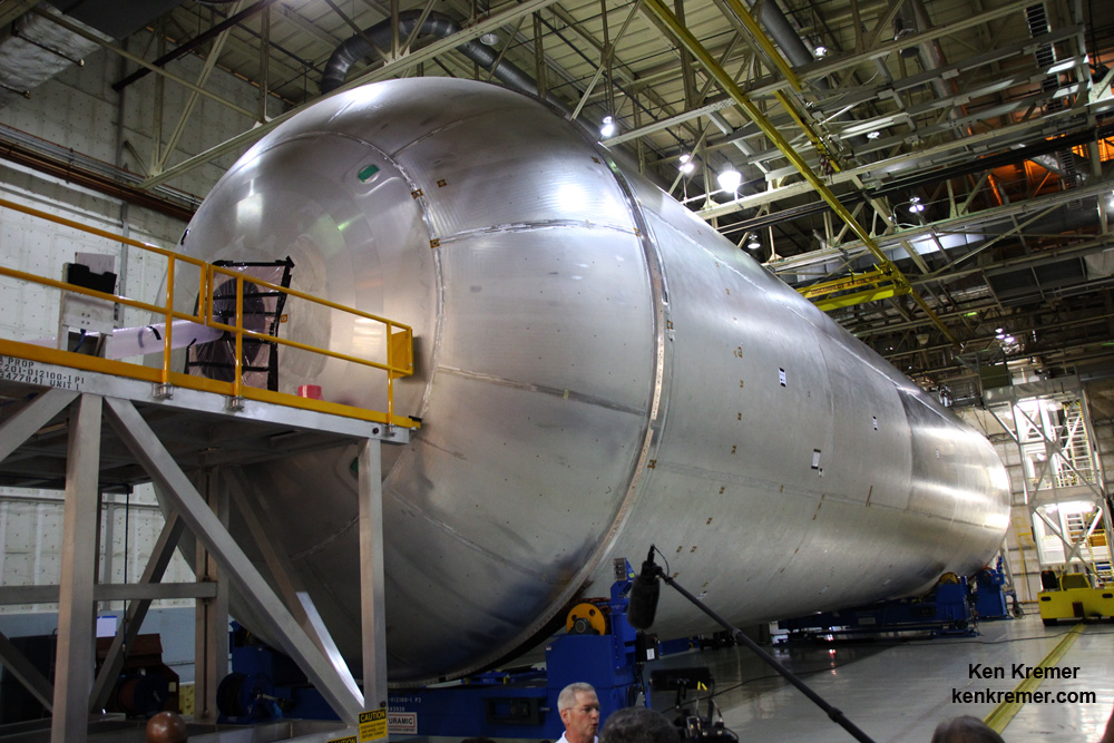
Welding is nearly complete on the liquid hydrogen tank will provide the fuel for the first flight of NASA’s new rocket, the Space Launch System, with the Orion spacecraft in 2018. The tank has now completed welding on the Vertical Assembly Center at NASA’s Michoud Assembly Facility in New Orleans. Credit: Ken Kremer/kenkremer.com
The 2018 launch of NASA’s Orion on the unpiloted EM-1 mission counts as the first joint flight of SLS and Orion, and the first flight of a human rated spacecraft to deep space since the Apollo Moon landing era ended more than 4 decades ago.
Now it might actually include humans.
Details to follow.
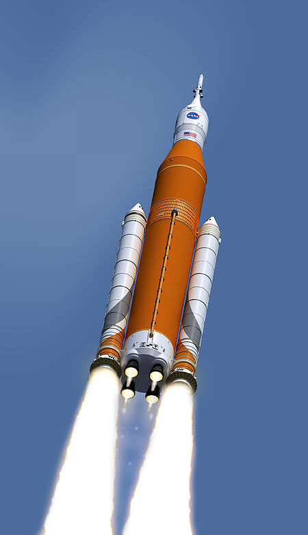
An artist’s interpretation of NASA’s Space Launch System Block 1 configuration with an Orion vehicle. Image: NASA
Orion is designed to send astronauts deeper into space than ever before, including missions to the Moon, asteroids and the Red Planet.
The liquid hydrogen tank qualification test article for NASA’s new Space Launch System (SLS) heavy lift rocket lies horizontally after final welding was completed at NASA’s Michoud Assembly Facility in New Orleans in July 2016. Credit: Ken Kremer/kenkremer.com
Stay tuned here for Ken’s continuing Earth and Planetary science and human spaceflight news.
This artist concept depicts the Space Launch System rocket rolling out of the Vehicle Assembly Building at NASA’s Kennedy Space Center. SLS will be the most powerful rocket ever built and will launch the agency’s Orion spacecraft into a new era of exploration to destinations beyond low-Earth orbit. Credits: NASA/Marshall Space Flight Center
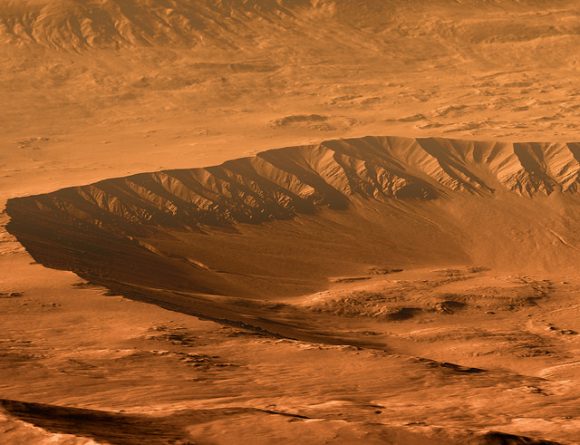
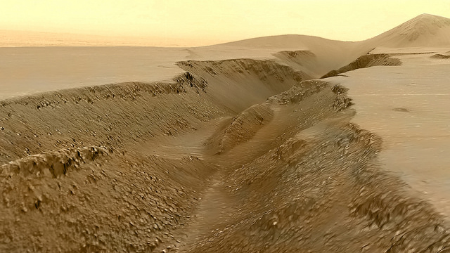
The rim of Tooting Crater on Mars, rendered from HiRISE data using Autodesk Maya and Adobe Photoshop. Credit: NASA/JPL/University of Arizona/USGS/image editing by Kevin Gill.
By day, Kevin Gill is a software engineer at the Jet Propulsion Laboratory. But on nights and weekends he takes data from spacecraft and turns them into scenes that can transport you directly to the surface of Mars.
Gill is one of many so-called “amateur” image editing enthusiasts that take real, high-resolution data from spacecraft and create views that can make you feel like you are standing on the surface of Mars, or out flying around the Solar System.
Gasa Crater on Mars. Rendered using Autodesk Maya and Adobe Photoshop. HiRISE data processed using HiView and gdal. Credit: NASA/JPL/University of Arizona/USGS/image editing by Kevin Gill.
Some of the best data around for these purposes come from the HiRISE camera on board the Mars Reconnaissance Orbiter. Data known as Digital Terrain Model (DTM) files, the HiRISE DTMs are made from two or more images of the same area of a region on Mars, taken from different angles. This data isn’t just for making stunning images or amazing movies. For scientists, DTMs are very powerful research tools, used to take measurements such a elevation information and model geological processes.
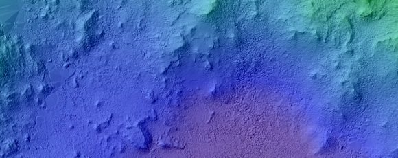
So, just how do you go from this DTM image from HiRISE:
DTM image of the Central Peak of Elorza Crater on Mars. Credit: NASA/JPL/University of Arizona/USGS
To this amazing image?
Martian sunrise over the Central Peak of Elorza Crater. Rendered using Autodesk Maya and Adobe Photoshop. HiRISE data processed using HiView and gdal. Credit: NASA/JPL/University of Arizona/USGS/image editing by Kevin Gill
I’m going to let Kevin explain it:
To prep the data, I use Photoshop (to convert the JP2 file to a TIFF), and then standard GIS tools like gdal (Geospatial Data Abstraction Library) to create textures for 3D modeling. Using Autodesk Maya, I input those into a material as a color texture (orthoimagery) or displacement map (the DTM data).
I connect that material to a NURBS plane (sort of like a polygon mesh) that is scaled similarly to the physical properties of the data. I set up a camera at a nice angle (it takes a number of low-resolution test renders to get an angle I like) and let it render.
Then I just pull that render into Photoshop where I have a series of monochromatic color tints which gives the image it’s Martian feel. For the sky, I use either a sky from a MSL MastCam image or one that I took outside with my cell phone. If I’m using a sky I took with my cell phone, I’ll adjust the colors to make it look more like it would on Mars. If the colors in the image are still boring at this point, I may run a HDR adjustment on it in Photoshop.
Fissure in the Cerberus region. This false color view of a volcanic fissure in the Cerberus region of Mars was created using a digital terrain model (DTM) from the High Resolution Imaging Science Experiment (HiRISE) camera aboard NASA’s Mars Reconnaissance Orbiter. The horizon was taken from Curiosity Mastcam imagery. Credit: NASA/JPL-Caltech/University of Arizona/ image editing by Kevin Gill.
What all this means is that you can create all these amazing view, plus incredible flyover videos, like this one Kevin put together of Endeavour Crater:
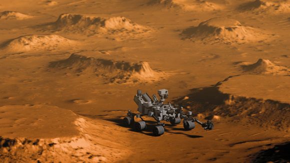
Or you can have some fun and visualize where the Curiosity rover is sitting:
Doin’ Science with Curiosity. Created using HiRIST DTM and Ortho data and NASA model of Curiosity. Rendered using Autodesk Maya and Adobe Photoshop. Curiosity Model: Brian Kumanchik, NASA/JPL-Caltech. Image editing by Kevin Gill.
We’ve written about this type of image editing previously, with the work of the people at UnmannedSpaceflight.com and others. Of course, the image editing software keeps improving, along with all the techniques.
Kevin also wanted to point out the work of other image editing enthusiast, Sean Doran.
“Sean’s work is resulting in views similar to mine,” Kevin said via email. “I know he’s using a process very different from mine, but we are thinking along the same lines in what we want out of the end product. His are quite impressive.”
For example, here is a flyover video of the Opportunity rover sitting along the rim of Endeavour Crater:
To accomplish its science objectives, NASA’s Juno spacecraftorbits over Jupiter’s poles and passes repeatedly through hazardous radiation belts. Two Boston University researchers propose using Juno to probe the ever-changing flux of volcanic gases-turned-ions spewed by Io’s volcanoes. Credit: NASA/JPL-Caltech
Jupiter may be the largest planet in the Solar System with a diameter 11 times that of Earth, but it pales in comparison to its own magnetosphere. The planet’s magnetic domain extends sunward at least 3 million miles (5 million km) and on the back side all the way to Saturn for a total of 407 million miles or more than 400 times the size of the Sun.
Jupiter’s large magnetic field interacts with the solar wind to form an invisible magnetosphere. If we were able to see it, it would span at least several degrees of sky. It would show its greatest extent when viewing Jupiter from the side at quadrature, when the planet stands due south at sunrise or sunset.In the artist’s depiction, the planet would be located between the two “purple eyes” — too small to see at this scale. Credit: NASA.
If we had eyes adapted to see the Jovian magnetosphere at night, its teardrop-like shape would easily extend across several degrees of sky! No surprise then that Jove’s magnetic aura has been called one of the largest structures in the Solar System.
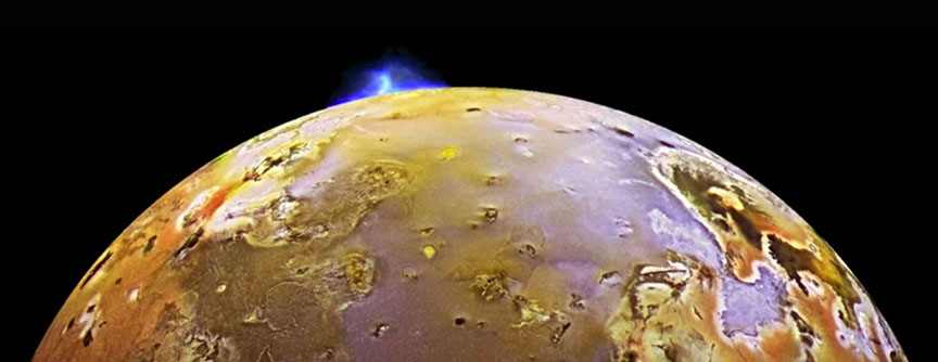
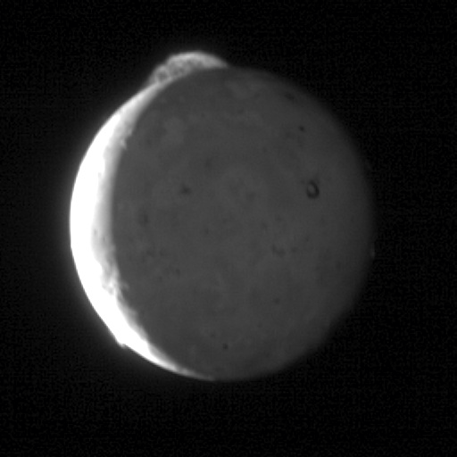
A 5-frame sequence taken by the New Horizons spacecraft in May 2007 shows a cloud of volcanic debris from Io’s Tvashtar volcano. The plume extends some 200 miles (330 km) above the moon’s surface. Credit: NASA/Johns Hopkins University Applied Physics Laboratory/Southwest Research Institute
Io, Jupiter’s innermost of the planet’s four large moons, orbits deep within this giant bubble. Despite its small size — about 200 miles smaller than our own Moon — it doesn’t lack in superlatives. With an estimated 400 volcanoes, many of them still active, Io is the most volcanically active body in the Solar System. In the moon’s low gravity, volcanoes spew sulfur, sulfur dioxide gas and fragments of basaltic rock up to 310 miles (500 km) into space in beautiful, umbrella-shaped plumes.
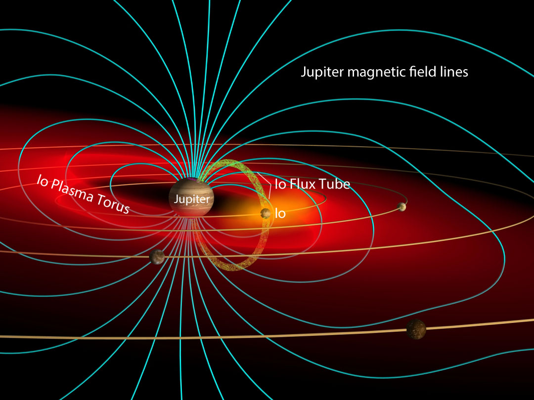
This schematic of Jupiter’s magnetic environments shows the planets looping magnetic field lines (similar to those generated by a simple bar magnet), Io and its plasma torus and flux tube. Credit: John Spencer / Wikipedia CC-BY-SA3.0 with labels by the author
Once aloft, electrons whipped around by Jupiter’s powerful magnetic field strike the neutral gases and ionize them (strips off their electrons). Ionized atoms and molecules (ions) are no longer neutral but possess a positive or negative electric charge. Astronomers refer to swarms of ionized atoms as plasma.
Jupiter rotates rapidly, spinning once every 9.8 hours, dragging the whole magnetosphere with it. As it spins past Io, those volcanic ions get caught up and dragged along for the ride, rotating around the planet in a ring called the Io plasma torus. You can picture it as a giant donut with Jupiter in the “hole” and the tasty, ~8,000-mile-thick ring centered on Io’s orbit.
That’s not all. Jupiter’s magnetic field also couples Io’s atmosphere to the planet’s polar regions, pumping Ionian ions through two “pipelines” to the magnetic poles and generating a powerful electric current known as the Io flux tube. Like firefighters on fire poles, the ions follow the planet’s magnetic field lines into the upper atmosphere, where they strike and excite atoms, spawning an ultraviolet-bright patch of aurora within the planet’s overall aurora. Astronomers call it Io’s magnetic footprint. The process works in reverse, too, spawning auroras in Io’s tenuous atmosphere.
The tilt of Juno’s orbit relative to Jupiter changes over the course of the mission, sending the spacecraft increasingly deeper into the planet’s intense radiation belts. Orbits are numbered from early in the mission to late. Credit: NASA/JPL-Caltech
Io is the main supplier of particles to Jupiter’s magnetosphere. Some of the same electrons stripped from sulfur and oxygen atoms during an earlier eruption return to strike atoms shot out by later blasts. Round and round they go in a great cycle of microscopic bombardment! The constant flow of high-speed, charged particles in Io’s vicinity make the region a lethal environment not only for humans but also for spacecraft electronics, the reason NASA’s Juno probe gets the heck outta there after each perijove or closest approach to Jupiter.
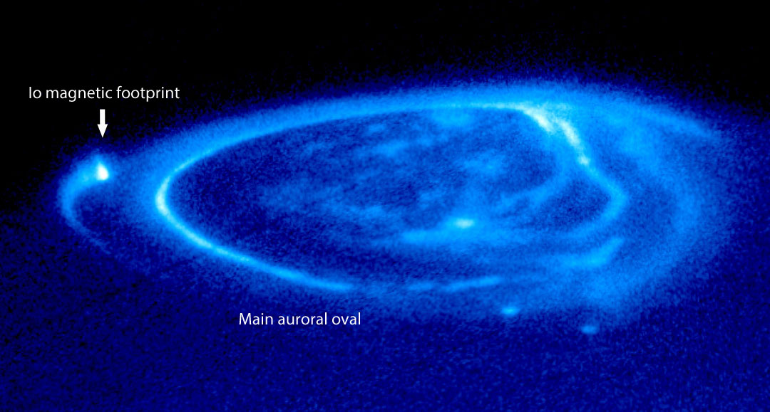
Io’s flux tube directs ions down Jupiter’s magnetic field lines to create magnetic footprints of enhanced aurora in Jupiter’s polar regions. An electric current of 5 million amps flows along Io’s flux tube.Credit: NASA/J.Clarke/HST
But there’s much to glean from those plasma streams. Astronomy PhD student Phillip Phipps and assistant professor of astronomy Paul Withers of Boston University have hatched a plan to use the Juno spacecraft to probe Io’s plasma torus to indirectly study the timing and flow of material from Io’s volcanoes into Jupiter’s magnetosphere. In a paper published on Jan. 25, they propose using changes in the radio signal sent by Juno as it passes through different regions of the torus to measure how much stuff is there and how its density changes over time.
The technique is called a radio occultation. Radio waves are a form of light just like white light. And like white light, they get bent or refracted when passing through a medium like air (or plasma in the case of Io). Blue light is slowed more and experiences the most bending; red light is slowed less and refracted least, the reason red fringes a rainbow’s outer edge and blue its inner. In radio occultations, refraction results in changes in frequency caused by variations in the density of plasma in Io’s torus.
The best spacecraft for the attempt is one with a polar orbit around Jupiter, where it cuts a clean cross-section through different parts of the torus during each orbit. Guess what? With its polar orbit, Juno’s the probe for the job! Its main mission is to map Jupiter’s gravitational and magnetic fields, so an occultation experiment jives well with mission goals. Previous missions have netted just two radio occultations of the torus, but Juno could potentially slam dunk 24.
New Horizons took this photo of Io in infrared light. The Tvastar volcano is bright spot at top. At least 10 other volcanic hot spots dot the moon’s night side. Credit: NASA/JHUPL/SRI
Because the paper was intended to show that the method is a feasible one, it remains to be seen whether NASA will consider adding a little extra credit work to Juno’s homework. It seems a worthy and practical goal, one that will further enlighten our understanding of how volcanoes create aurorae in the bizarre electric and magnetic environment of the largest planet.
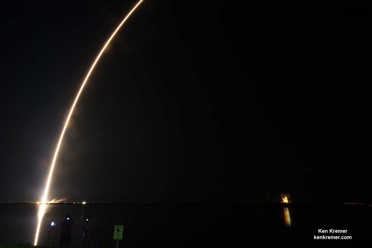
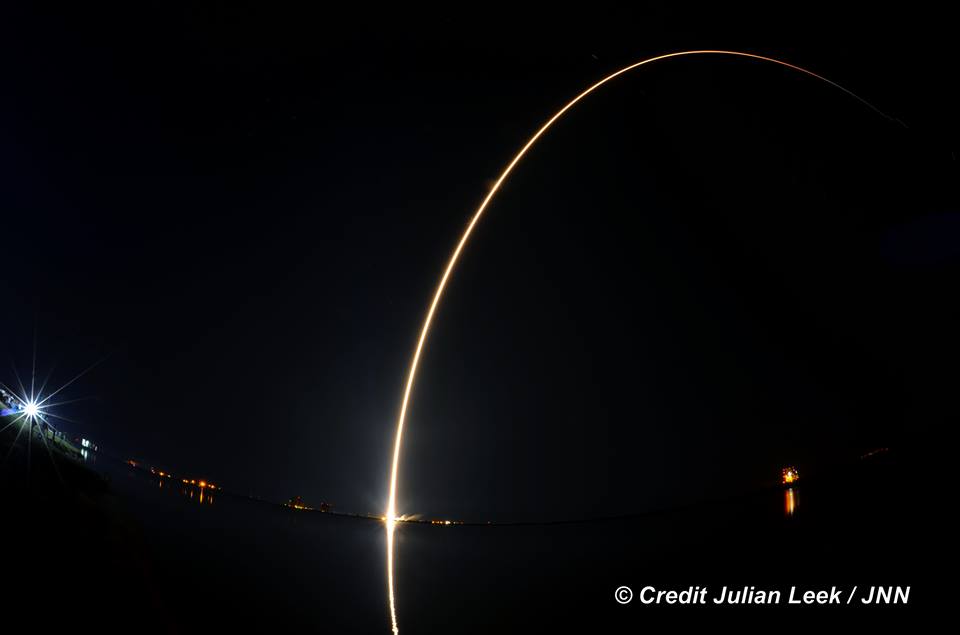
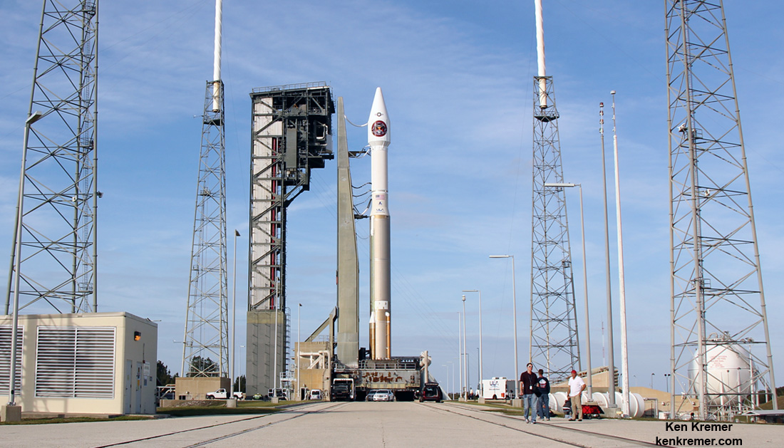
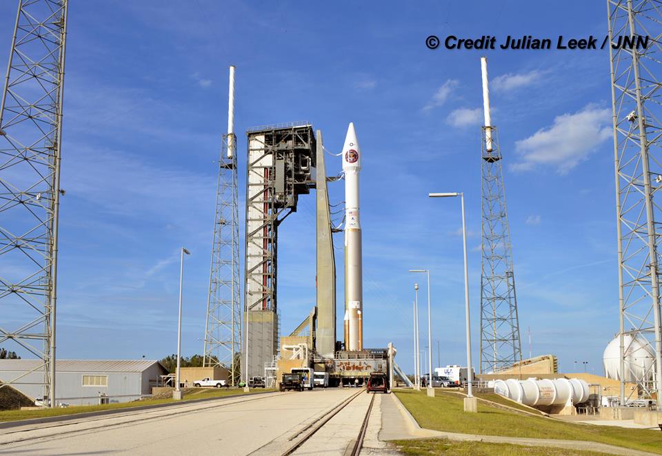
ULA Atlas V rocket carrying the USAF SBIRS GEO 3 missile defense satellite streaks to orbit on Jan. 20, 2017 after nighttime blastoff at 7:42 p.m. ET from Space Launch Complex-41 at Cape Canaveral Air Force Station in Florida Credit: Ken Kremer/kenkremer.com
ULA Atlas V rocket carrying the USAF SBIRS GEO 3 missile defense satellite streaks to orbit on Jan. 20, 2017 after nighttime blastoff at 7:42 p.m. ET from Space Launch Complex-41 at Cape Canaveral Air Force Station in Florida. Credit: Ken Kremer/kenkremer.com
CAPE CANAVERAL AIR FORCE STATION, FL – A U.S. Air Force missile defense reconnaissance observatory that will track the telltale infrared signatures of incoming enemy missiles and is vital to America’s national security blasted off in spectacular fashion this evening, Jan. 20, 2017, as it streaked to orbit from the Florida Space Coast.
The United Launch Alliance Atlas V rocket carrying the $1.2 Billion Space Based Infrared System (SBIRS) GEO Flight 3 infrared imaging satellite lifted off at 7:42 p.m. ET from Space Launch Complex-41 on Cape Canaveral Air Force Station, Fla. – marking the first US east coast launch of 2017.
The SBIRS GEO Flight 3 was launched to geosynchronous transfer orbit to an altitude approx 22,000 miles (36,000 kilometers) above Earth.
The Atlas V was launched southeast at an inclination of 23.29 degrees. SBIRS GEO Flight 3 separated from the 2nd stage as planned 43 minutes after liftoff.
It is also the first of at least eleven launches of Atlas and Delta rockets by the aerospace firm this year.
The on time launch took place at the opening of the 40 minute launch window and after a 24 hour delay – when the launch was scrubbed yesterday (Jan. 19) after an aircraft flew into the Cape’s restricted airspace and could not be diverted in time before the launch window closed.
ULA also had to address sensor issues with the Atlas rockets RD-180 main engine during Thursday’s countdown.
Due to the scrub, the Atlas liftoff counts as the first launch of the Trump Administration rather the last of the Obama Administration.
With the unpredictable North Korean dictator Kim John Un threatening to launch an upgraded long range intercontinental ballistic missile this year that could potentially strike the United States west coast, SBIRS GEO 3 is more important than ever for our national defense.
ULA Atlas V rocket carrying the USAF SBIRS GEO 3 missile defense satellite streaks to orbit on Jan. 20, 2017 after nighttime blastoff at 7:42 p.m. ET from Space Launch Complex-41 at Cape Canaveral Air Force Station in Florida. Credit: Julian Leek
The SBIRS GEO Flight 3 is considered to be one of the highest priority military space programs in defense of the homeland.
The Space Based Infrared System is designed to provide global, persistent, infrared surveillance capabilities to meet 21st century demands in four national security mission areas: missile warning, missile defense, technical intelligence and battlespace awareness.
SBIRS will supplement and replace the legacy Defense Support Program (DSP) satellites currently in orbit and features vastly increased early missile detection and warning capabilities.
“ULA is proud to deliver this critical satellite which will improve surveillance capabilities for our national decision makers,” said Laura Maginnis, ULA vice president of Government Satellite Launch, in a statement.
“I can’t think of a better way to kick off the new year.”
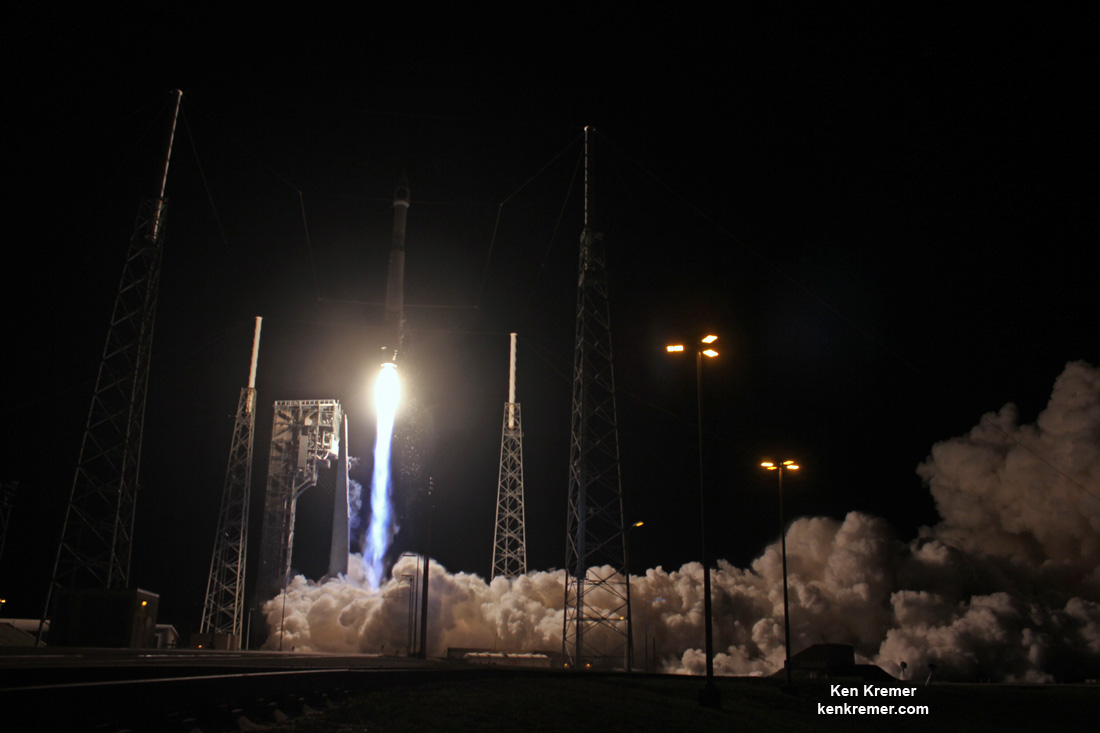
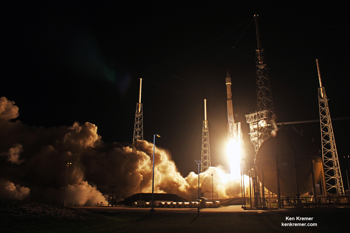
A United Launch Alliance (ULA) Atlas V rocket carrying SBIRS GEO Flight 3 satellite lifts off at 7:42 p.m. ET on Jan. 20, 2017 from Space Launch Complex-41 on Cape Canaveral Air Force Station in Florida. Credit: Ken Kremer/kenkremer.com
ULA is a joint venture of Boeing and Lockheed Martin with 116 successful launches under its belt after today’s liftoff.
The 194-foot-tall commercial Atlas V booster launched in the 401 rocket configuration with approximately 860,000 pounds of sea level first stage thrust powered by the dual nozzle Russian-built RD AMROSS RD-180 engine. There are no thrust augmenting solids attached to the first stage.
The satellite is housed inside a 4-meter diameter large payload fairing (LPF). The Centaur upper stage is powered by the Aerojet Rocketdyne RL10C engine.
Watch this video showing the detailed mission profile:
Video Caption: An Atlas V 401 configuration rocket will deliver the Air Force’s third Space-Based Infrared System (SBIRS) satellite to orbit. SBIRS, considered one of the nation’s highest priority space programs, is designed to provide global, persistent, infrared surveillance capabilities to meet 21st century demands. Credit: ULA
This mission marks the 34th Atlas V mission in the 401 configuration.
“The Atlas V 401 configuration has become the workhorse of the Atlas V fleet, delivering half of all Atlas V missions to date” said Maginnis.
“ULA understands that even with the most reliable launch vehicles, our sustained mission success is only made possible with seamless integration between our customer and our world class ULA team.”
ULA Atlas V rocket carrying SBIRS GEO Flight 3 missile tracking observatory lifts off at 7:42 p.m. ET on Jan. 20, 2017 from Space Launch Complex-41 on Cape Canaveral Air Force Station in Florida. Credit: Ken Kremer/kenkremer.com
The two prior SBIRS GEO missions also launched on the ULA Atlas V 401 rocket.
The SBIRS team is led by the Remote Sensing Systems Directorate at the U.S. Air Force Space and Missile Systems Center. Lockheed Martin is the prime contractor, with Northrop Grumman as the payload integrator. Air Force Space Command operates the SBIRS system, according to a ULA description.
Stay tuned here for Ken’s continuing Earth and Planetary science and human spaceflight news.
ULA Atlas V rocket carrying the USAF SBIRS GEO 3 missile warning satellite is poised for blastoff from Space Launch Complex-41 at Cape Canaveral Air Force Station in Florida on Jan. 20, 2017. Credit: Ken Kremer/kenkremer.com Artwork for ULA Atlas V launch of SBIRS GEO Flight 3 mission on Jan. 19, 2017 from Canaveral Air Force Station, Florida. Credit: ULA
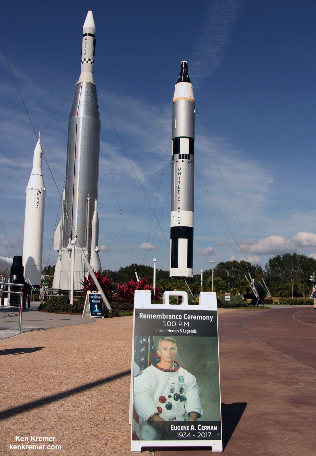
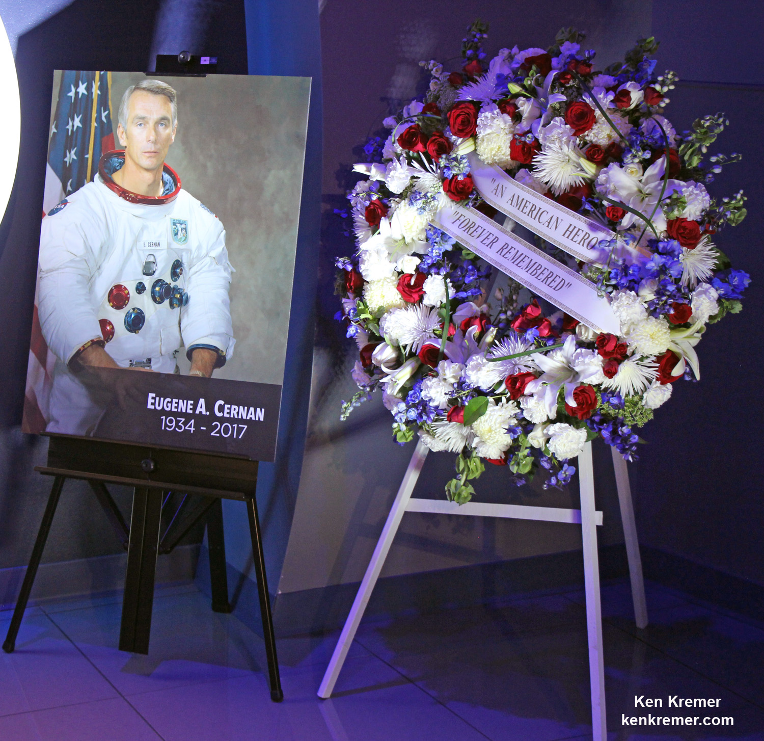
Remembrance Ceremony honoring the life of astronaut Eugene Cernan, last Man to walk on the Moon during NASA’s Apollo 17 moon landing mission in Dec. 1972, was held at the Kennedy Space Center Visitor Complex, Florida, on Jan. 18, 2017. Cernan passed away on Jan. 16, 2017. Credit: Ken Kremer/kenkremer.com
Remembrance Ceremony honoring the life of astronaut Eugene Cernan, last Man to walk on the Moon during NASA’s Apollo 17 moon landing mission in Dec. 1972, was held at the Kennedy Space Center Visitor Complex, Florida, on Jan. 18, 2017. Cernan passed away on Jan. 16, 2017. Credit: Ken Kremer/kenkremer.com
KENNEDY SPACE CENTER VISITOR COMPLEX, FL – Gene Cernan, the last man to walk on the Moon, and one of America’s most famous and renowned astronauts, was honored in a ceremony held at Kennedy Space Center Visitor Complex, Florida, on Jan. 18. [Story/photos expanded]
Cernan passed away earlier this week on Monday, January 16, 2017 at age 82, after a long illness, surrounded by his family.
Cernan, a naval aviator, flew on three groundbreaking missions for NASA during the Gemini and Apollo programs that paved the way for America’s and humanity’s first moon landing missions.
His trio of historic space flights ultimately culminated with Cernan stepping foot on the moon in Dec. 1972 during the Apollo 17 mission- NASA final moon landing of the Apollo era.
No human has set foot on the Moon since Apollo 17 – an enduring disappointment to Cernan and all space fans worldwide.
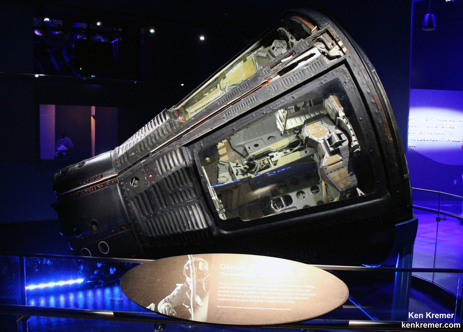
Cernan also flew on the Gemini 9 and Apollo 10 missions, prior to Apollo 17.
The Gemini 9 capsule is on display at the KSC Visitor Complex. Cernan was the second NASA astronaut to perform an EVA – during Gemini 9.
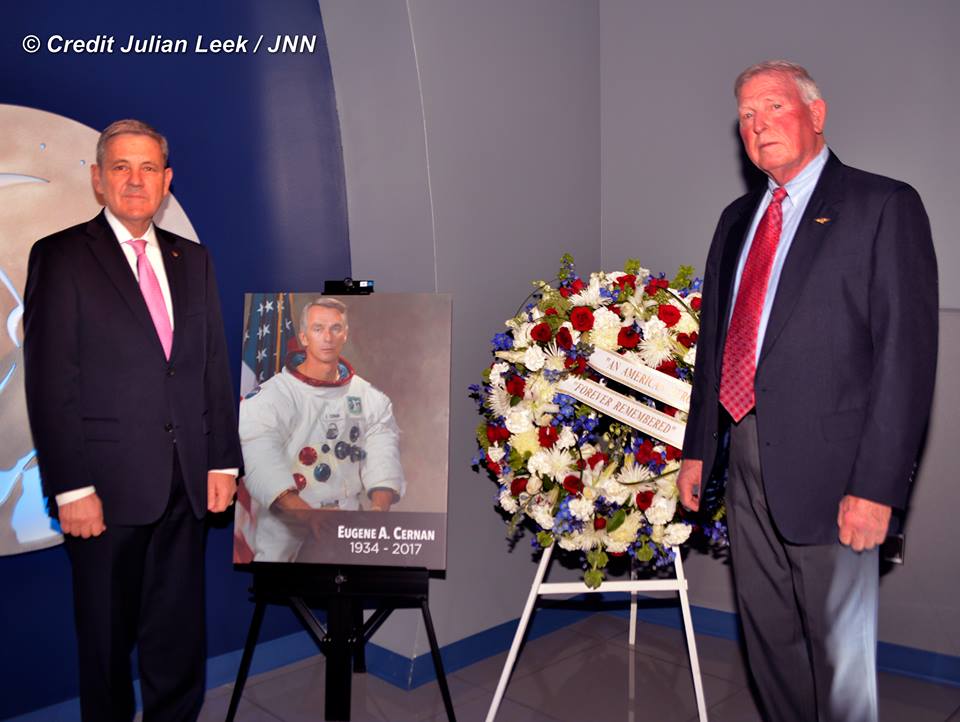
The Cernan remembrance ceremony was held at the U.S. Astronaut Hall of Fame inside the newly opened ‘Heroes & Legends’ exhibit at the KSC Visitor Complex – two days after Cernan died. It included remarks from two of his fellow NASA astronauts from the Space Shuttle era, Kennedy Space Center Director Bob Cabana, and space shuttle astronaut Jon McBride, as well as Therrin Protze, chief operating officer, Kennedy Space Center Visitor Complex.
Robert Cabana, director of NASA’s Kennedy Space Center and space shuttle astronaut Jon McBride, following remarks at the Jan 18, 2017 Remembrance Ceremony at the Kennedy Space Center Visitor Complex, Florida, honoring the life of astronaut Eugene Cernan. Credit: Julian Leek
A NASA portrait and floral wreath were on display for visitors during the ceremony inside and outside of the ‘Heroes and Legends’ exhibit.
“He was an advocate for the space program and hero that will be greatly missed,” said Kennedy Space Center Director Bob Cabana during the ceremony inside.
“I don’t believe that Gene is going to be the last man on the moon. And one of the things that he was extremely passionate about was our exploring beyond our own planet, and developing that capability that would allow us to go back to the moon and go beyond.
“I feel badly that he wasn’t able to stay alive long enough to actually see this come to fruition,” Cabana said.
Portrait of NASA astronaut Gene Cernan and floral wreath displayed during the Jan. 18, 2017 Remembrance Ceremony at the Kennedy Space Center Visitor Complex, Florida, honoring his life as the last Man to walk on the Moon. Credit: Ken Kremer/kenkremer.com
NASA is now developing the SLS heavy lift rocket and Orion deep space capsule to send our astronauts to the Moon, Mars and Beyond. The maiden launch of SLS-1 on the uncrewed EM-1 mission to the Moon is slated for Fall 2018.
“We are saddened of the loss of our American hero, Astronaut Gene Cernan. As the last man to place footsteps on the surface of the moon, he was a truly inspiring icon who challenged the impossible,” said Therrin Protze, chief operating officer of Kennedy Space Center Visitor Complex.
“People throughout generations have been and will forever be inspired by his actions, and the underlying message that what we can achieve is limited only by our imaginations. He will forever be known as ‘The Last Man on the Moon,” and for the extraordinary impact he had on our country and the world.”
Cernan was one of only 12 astronauts to walk on the moon. Neil Armstong and Buzz Aldrin were the first during the Apollo 11 moon landing mission in 1969 that fulfilled President Kohn F. Kennedy’s promise to land on the Moon during the 1960’s.
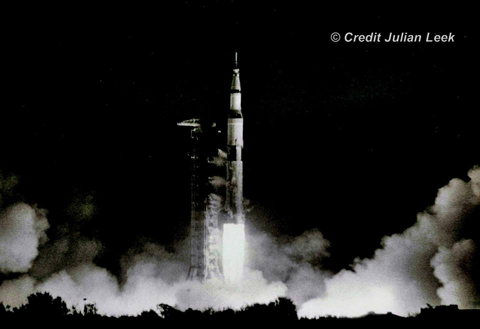
Launch of Apollo 17 – NASA’s last lunar landing mission – on 7 December 1972 from Launch Complex-39A on the Kennedy Space Center, Florida. Credit: Julian Leek
Cernan retired from NASA and the U.S. Navy in 1976. He continued to advise NASA as a consultant and appeared frequently on TV news programs during NASA’s manned space missions as an popular guest explaining the details of space exploration and why we should explore.
He advocated for NASA, space exploration and science his entire adult life.
The prime crew for the Apollo 17 lunar landing mission are: Commander, Eugene A. Cernan (seated), Command Module pilot Ronald E. Evans (standing on right), and Lunar Module pilot, Harrison H. Schmitt (left). They are photographed with a Lunar Roving Vehicle (LRV) trainer. Cernan and Schmitt used an LRV during their exploration of the Taurus-Littrow landing site. The Apollo 17 Saturn V Moon rocket is in the background. This picture was taken during October 1972 at Launch Complex 39A, Kennedy Space Center (KSC), Florida. Credit: Julian Leek
“As an astronaut, Cernan left an indelible impression on the moon when he scratched his daughter’s initials in the lunar surface alongside the footprints he left as the last human to walk on the moon. Guests of Kennedy Space Center Visitor Complex can learn more about Cernan’s legacy at the new Heroes & Legends exhibit, where his spacewalk outside the actual Gemini IX space capsule is brought to life through holographic imagery.”
Actual Gemini 9 capsule piloted by Gene Cernan with Commander Thomas P. Stafford on a three-day flight in June 1966 on permanent display in the Heroes and Legends exhibit at the Kennedy Space Center Visitor Complex, Florida. Cernan logged more than two hours outside the orbiting capsule, as depicted in description. Credit: Ken Kremer/kenkremer.com
From NASA’s profile page:
“Cernan was born in Chicago on March 14, 1934. He graduated from Proviso Township High School in Maywood, Ill., and received a bachelor of science degree in electrical engineering from Purdue University in 1956. He earned a master of science degree in aeronautical engineering from the U.S. Naval Postgraduate School in Monterey, Calif.
Cernan is survived by his wife, Jan Nanna Cernan, his daughter and son-in-law, Tracy Cernan Woolie and Marion Woolie, step-daughters Kelly Nanna Taff and husband, Michael, and Danielle Nanna Ellis and nine grandchildren.”
The following is a statement released by NASA on the behalf of Gene Cernan’s family:
A funeral service for Capt. Eugene A. Cernan, who passed away Monday at the age of 82, will be conducted at 2:30 p.m. CST on Tuesday, Jan. 24, at St. Martin’s Episcopal Church, 717 Sage Road in Houston.
NASA Television will provide pool video coverage of the service.
The family will gather for a private interment at the Texas State Cemetery in Austin at a later date, where full military honors will be rendered.
Stay tuned here for Ken’s continuing Earth and Planetary science and human spaceflight news.
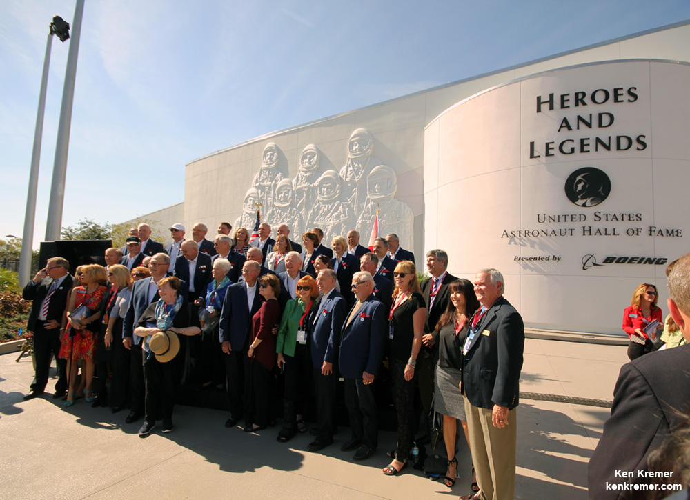
Grand opening ceremony for the ‘Heroes and Legends’ attraction on Nov. 11, 2016 at the Kennedy Space Center Visitor Complex in Florida and attended by more than 25 veteran and current NASA astronauts. Credit: Ken Kremer/kenkremer.com
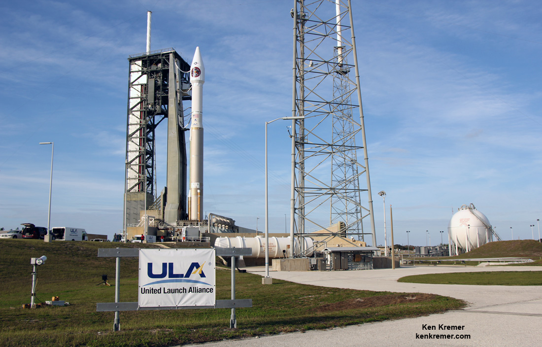
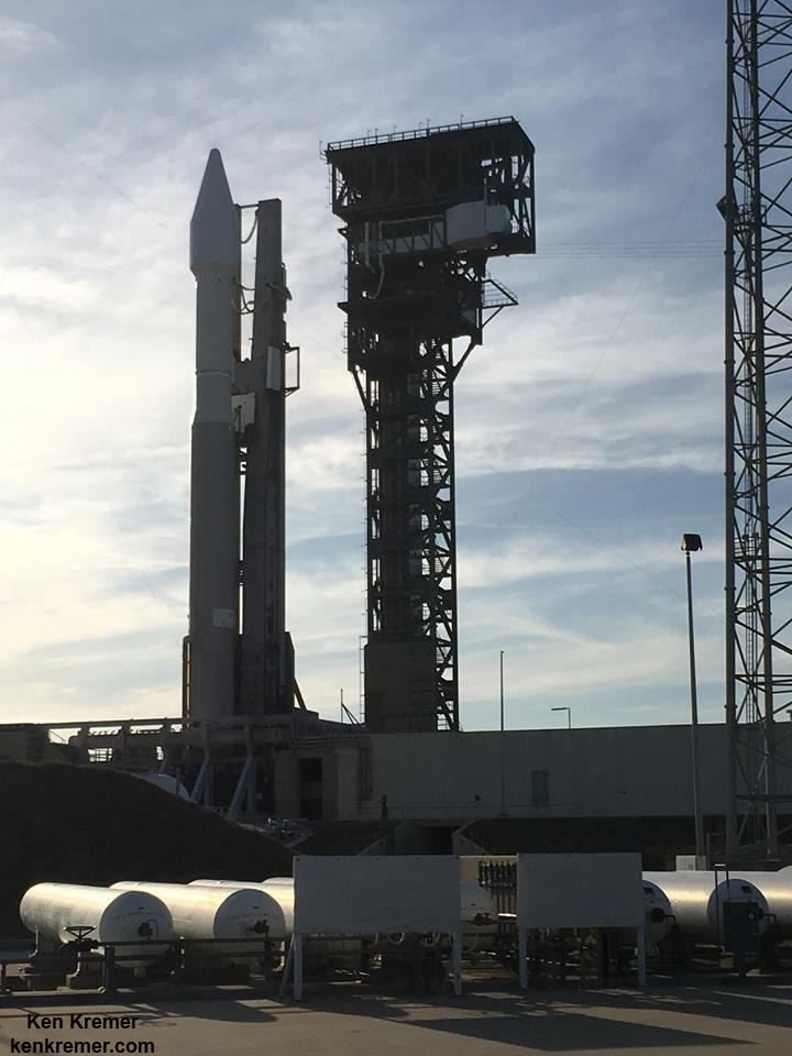
ULA Atlas V rocket carrying the USAF SBIRS GEO 3 missile warning satellite is poised for blastoff from Space Launch Complex-41 at Cape Canaveral Air Force Station in Florida on Jan. 19 , 2017. Credit: Ken Kremer/kenkremer.com
ULA Atlas V rocket carrying the USAF SBIRS GEO 3 missile warning satellite is poised for blastoff from Space Launch Complex-41 at Cape Canaveral Air Force Station in Florida on Jan. 19 , 2017. Credit: Ken Kremer/kenkremer.com
CAPE CANAVERAL AIR FORCE STATION, FL – A U.S. Air Force satellite that will provide vital early warnings on incoming enemy missiles that are critical to the defense of our homeland is set for a spectacular nighttime blastoff on Thursday Jan. 19 from the Florida Space Coast. Update: Launch reset to Jan 20 at 7:42 pm EST
The Atlas V rocket carrying the $1.2 Billion SBIRS GEO Flight 3 infrared imaging satellite counts as the first launch of 2017 by rocket builder United Launch Alliance (ULA) as well as the years first liftoff from Cape Canaveral.
The ULA Atlas V rocket is set for liftoff on Thursday, Jan. 19 from Space Launch Complex-41 at Cape Canaveral Air Force Station in Florida.
The Space Based Infrared System (SBIRS) satellite will be launched to geosynchronous transfer orbit.
It is the third satellite in this series of infrared surveillance satellites that will provide rapid and accurate warning of attacking enemy strategic missiles via infrared signatures – as well as critical targeting data to US missile defense systems to enable swiftly responding launches that will hopefully destroy the attackers in the battle space arena before impacting US cities, infrastructure and military installations.
USAF SBIRS GEO 3 missile warning satellite under construction by prime contractor Lockheed Martin. Credit: Lockheed Martin
The 20 story tall rocket and payload were rolled out vertically this morning some 1800 feet (600 m) from the Vertical Integration Facility (VIF) processing hangar to pad 41.
With the unpredictable North Korean dictator Kim John Un threatening to launch an upgraded long range intercontinental ballistic missile this year that could potentially strike the United States west coast, SBIRS GEO 3 is more important than ever for our national defense.
The launch window opens at 7:46 p.m. EST (0046 GMT).
The launch window extends for 40 minutes from 7:46-8:26 p.m. EST.
Spectators are flocking into Space Coast area hotels for the super convenient dinnertime blastoff. And they will have a blast ! – if all goes well.
You can watch the Atlas launch live via a ULA webcast. The live launch broadcast will begin about 20 minutes before the planned liftoff at 7:26 p.m. EST here:
The current launch weather forecast for Thursday, Jan. 18, calls for an 80 percent chance of acceptable weather conditions at launch time. The primary concern is for cumulus clouds.
The backup launch opportunity is on Friday.
In case of a scrub for any reason, technical or weather, the chances for a favorable launch drop slightly to 70% GO.
ULA Atlas V rocket carrying the USAF SBIRS GEO 3 missile warning satellite is poised for blastoff from Space Launch Complex-41 at Cape Canaveral Air Force Station in Florida on Jan. 19 , 2017. Credit: Julian Leek
“SBIRS, considered one of the nation’s highest priority space programs, is designed to provide global, persistent, infrared surveillance capabilities to meet 21st century demands in four national security mission areas including: missile warning, missile defense, technical intelligence and battlespace awareness.”
The first SBIRS satellite was launched in 2011.
SBIRS GEO 3 will launch southeast at an inclination of 23.29 degrees. It separate from the 2nd stage 43 minutes after liftoff.
ULA has enjoyed a 100% success rate for this 69th Atlas V launch stretching back to the company’s founding back in 2006.
ULA is a joint venture of Boeing and Lockheed Martin with 116 successful launches under its belt.
ULA Atlas V rocket carrying the USAF SBIRS GEO 3 missile warning satellite is poised for blastoff from Space Launch Complex-41 at Cape Canaveral Air Force Station in Florida on Jan. 19 , 2017. Credit: Ken Kremer/kenkremer.com
The 194-foot-tall commercial Atlas V booster launched in the 401 rocket configuration with approximately 860,000 pounds of sea level first stage thrust powered by the dual nozzle Russian-built RD AMROSS RD-180 engine. There are no thrust augmenting solids attached to the first stage.
The satellite is housed inside a 4-meter diameter large payload fairing (LPF). The Centaur upper stage is powered by the Aerojet Rocketdyne RL10C engine.
Watch this video showing the detailed mission profile:
Video Caption: An Atlas V 401 configuration rocket will deliver the Air Force’s third Space-Based Infrared System (SBIRS) satellite to orbit. SBIRS, considered one of the nation’s highest priority space programs, is designed to provide global, persistent, infrared surveillance capabilities to meet 21st century demands. Credit: ULA
This mission marks the 34th Atlas V mission in the 401 configuration.
The two prior SBIRS GEO missions also launched on the ULA Atlas V 401 rocket.
Up close look at the payload fairing housing SBIRS GEO 3atop ULA Atlas V rocket set for launch from pad 41 at Cape Canaveral Air Force Station, Fl. Credit: Lane Hermann
The SBIRS team is led by the Remote Sensing Systems Directorate at the U.S. Air Force Space and Missile Systems Center. Lockheed Martin is the prime contractor, with Northrop Grumman as the payload integrator. Air Force Space Command operates the SBIRS system, according to a ULA description.
ULA Atlas V rocket stands erect alongside newly built crew access tower at Cape Canaveral Air Force Station’s Space Launch Complex-41 ahead of Jan. 19, 2017 blastoff. Credit: Ken Kremer/kenkremer.com
Stay tuned here for Ken’s continuing Earth and Planetary science and human spaceflight news.
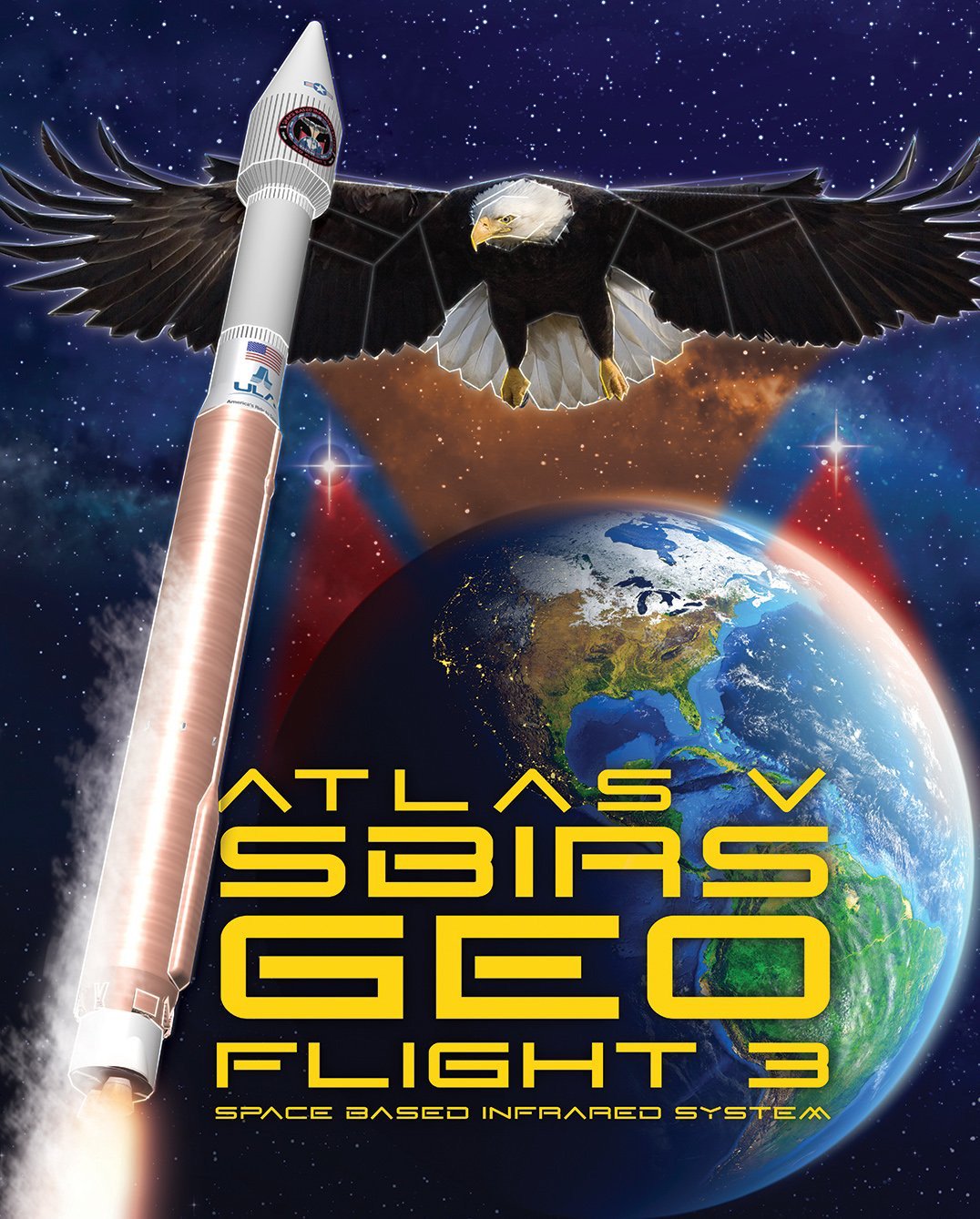
Mission patch for SBIRS GEO Flight 3. Credit: USAF
………….
Learn more about ULA SBIRS GEO 3 launch, EchoStar launch GOES-R launch, Heroes and Legends at KSCVC, OSIRIS-REx, InSight Mars lander, ULA, SpaceX and Orbital ATK missions, Juno at Jupiter, SpaceX AMOS-6 & CRS-9 rocket launch, ISS, ULA Atlas and Delta rockets, Orbital ATK Cygnus, Boeing, Space Taxis, Mars rovers, Orion, SLS, Antares, NASA missions and more at Ken’s upcoming outreach events:
Jan. 18/20/21: “ULA Atlas SBIRS GEO 3 launch, EchoStar 19 comsat launch, GOES-R weather satellite launch, OSIRIS-Rex, SpaceX and Orbital ATK missions to the ISS, Juno at Jupiter, ULA Delta 4 Heavy spy satellite, SLS, Orion, Commercial crew, Curiosity explores Mars, Pluto and more,” Kennedy Space Center Quality Inn, Titusville, FL, evenings
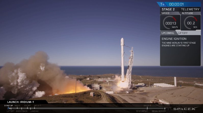
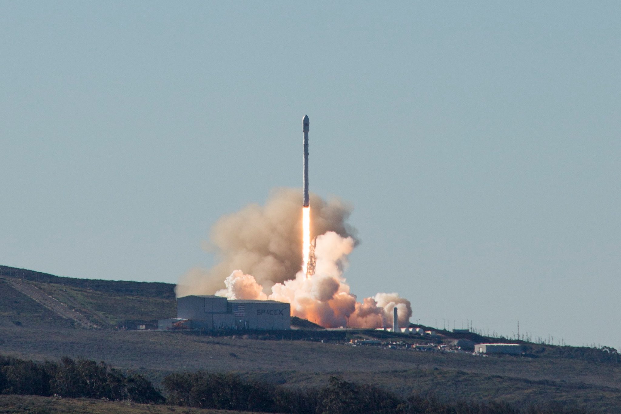
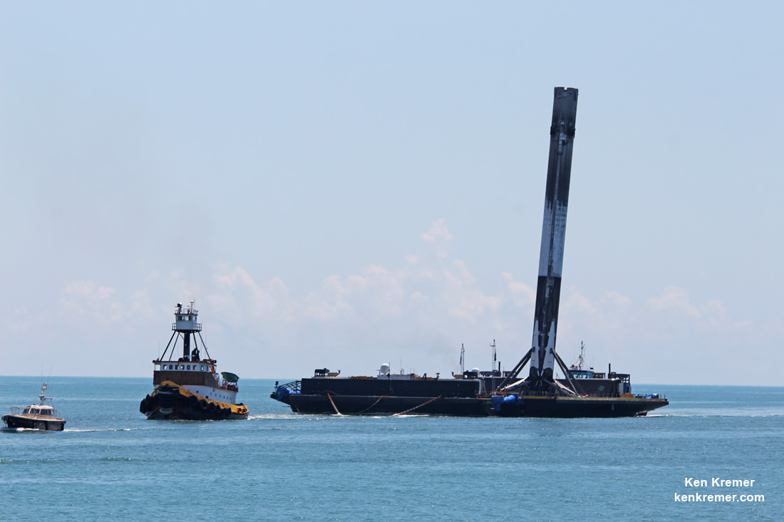
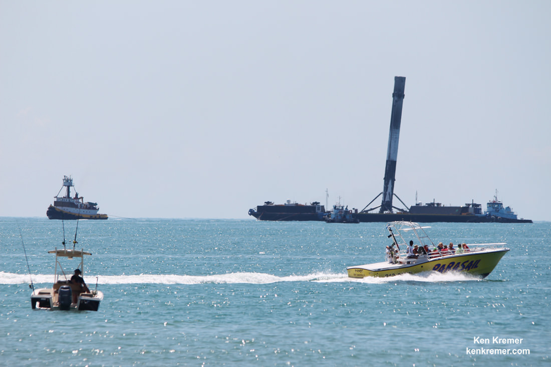
Picture perfect blastoff of SpaceX Falcon 9 on Jan. 14, 2017, Return to Flight launch from Vandenberg Air Force Base in California carrying fleet of ten advanced Iridium NEXT comsats to low Earth orbit. Credit: SpaceX
Picture perfect blastoff of SpaceX Falcon 9 on Jan. 14, 2017, Return to Flight launch from Vandenberg Air Force Base in California carrying fleet of ten advanced Iridium NEXT comsats to low Earth orbit. Credit: SpaceX
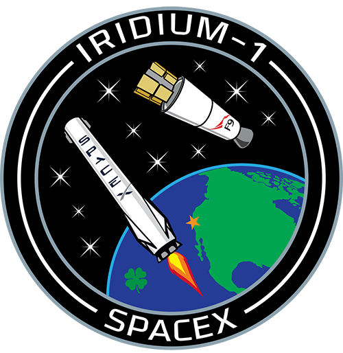
The primary goal of SpaceX’sFalcon 9 launch from Space Launch Complex 4E on Vandenberg Air Force Base in California was to deploy the payload of the first ten Iridium Next communication satellites to low Earth orbit on the Iridium-1 mission.
“Thanks @elonmusk – a perfect flight! Loved watching sats deploy with you in the control room,” tweeted Matt Desch, Iridium Communications CEO, soon after receiving full confirmation that all 10 Iridium NEXT satellites were successfully deployed from their second stage satellite dispensers.
“More to go, but now to celebrate!!”
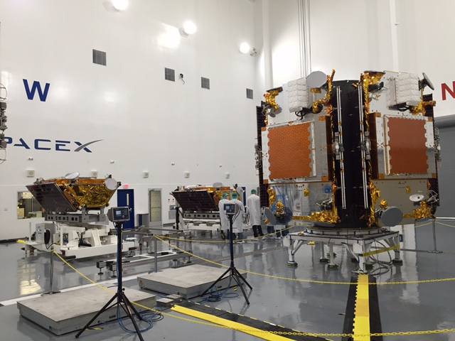
The inaugural ten will serve as the vanguard of a fleet that will eventually comprise 81 satellites.
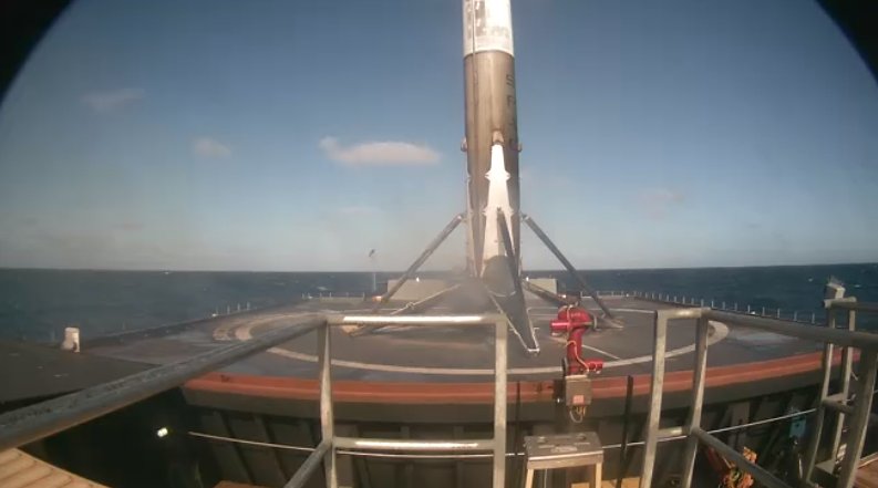
SpaceX Falcon 9 first stage successfully soft lands on drone ship stationed in the Pacific Ocean off California coast after launching on Jan. 14, 2017, from Vandenberg Air Force Base in California carrying fleet of ten advanced Iridium NEXT comsats to low Earth orbit. Credit: SpaceX
Another launch failure would have dealt a devastating blow to confidence in SpaceX’s hard won reputation.
The Sept. 1, 2016 calamity was the second Falcon 9 failure within 15 months time. Both occurred inside the second stage and called into question the rockets reliability.
The 229-foot (70-meter) Falcon 9 rocket was rolled out from its processing hangar to the launch pad and raised vertically yesterday.
Picture perfect blastoff of SpaceX Falcon 9 on Jan. 14, 2017, Return to Flight launch from Vandenberg Air Force Base in California carrying fleet of ten advanced Iridium NEXT comsats to low Earth orbit. Credit: SpaceX
Today’s entire land, landing and satellite deployment event was shown live on a SpaceX hosted webcast. It offered extremely sharp views of Saturdays on time liftoff at 9:54:34 a.m. PST or 12:54:34 p.m. EST, and unbelievably clear images of the first stage descending back to Earth towards a tiny drone ship.
“Overall a wonderfully nominal mission,” gushed the SpaceX commentator during the webcast.
Since the Iridium 1 mission only had an instantaneous launch opportunity precisely at 9:54:34 a.m. PST or 12:54:34 p.m. EST, there was no margin for any technical or weather delays. And none happened. Although an errant boat had to be quickly escorted out of the exclusion zone less than 20 minutes before blastoff.
Confirmation of a successful deployment of all 10 Iridium NEXT satellites came at about T plus 1 hour and 17 minutes after liftoff from Vandenberg.
“So, so excited – finally breathing again!” tweeted Desch.
“Thanks for all the great vibes – I felt it! All 10 sats deployed; good orbit; good telemetry! WOW.”
The mobile relay satellites were delivered into a circular orbit at an altitude of 625 kilometers (388 miles) above Earth.
They were released one at a time from a pair of specially designed satellite dispensers at approximately 100 second intervals.
“It was a clean sweep, 10 for 10,” said SpaceX commentator John Insprucker during the live webcast.
“All the bridge wires show open, and that is a conclusion of the primary mission today, a great one for the first stage, second stage, and the customer’s satellites deployed into a good orbit.”
The Iridium NEXT satellites were built by Thales Alenia and Orbital ATK.
In the final moments before the propulsive landing, you could read the lettering on the “Just Read the Instructions” drone ship as the engine was firing to slow the descent and the landing legs deployed.
Really there was no cutout or loss of signal the whole way down. So the world could watch every key moment as it happened in real time.
The first stage softly landed approx. 8 minutes and 18 seconds after the California liftoff.
“First stage has landed on Just Read the Instructions,” SpaceX tweeted post landing.
This was the first launch by SpaceX since last August from the Florida Space Coast, and it came off without a hitch.
Iridium 1 is the first of seven planned Falcon 9 launches to establish the Iridium NEXT constellation which will eventually consist of 81 advanced satellites.
At least 70 will be launched by SpaceX.
The inaugural launch of the advanced Iridium NEXT satellites will start the process of replacing an aging Iridium fleet in orbit for nearly two decades.
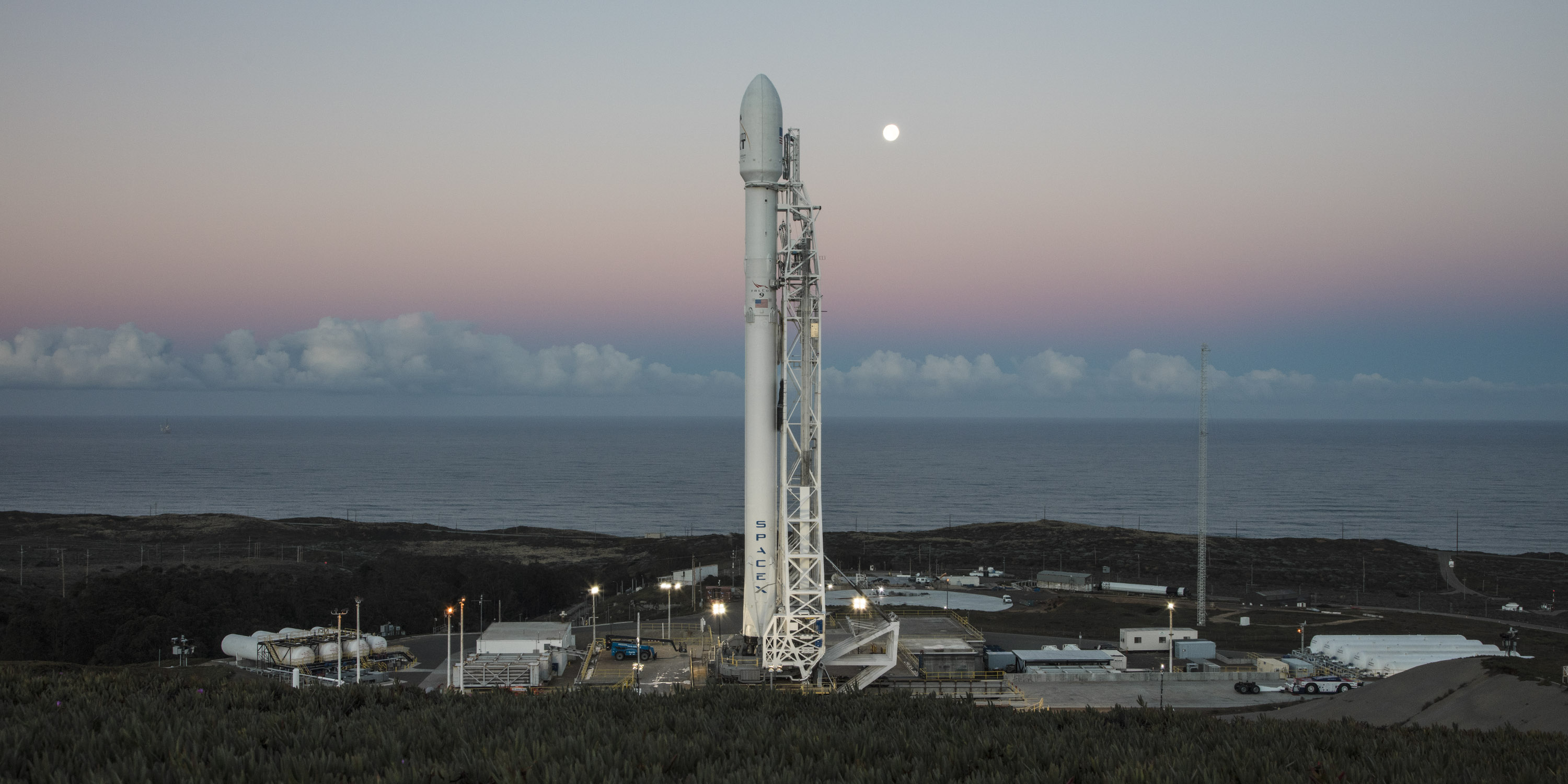
SpaceX Falcon 9 poised for Jan. 14, 2017, Return to Flight launch from Vandenberg Air Force Base in California carrying ten Iridium NEXT comsats to orbit. Credit: SpaceX
This Falcon 9 was been outfitted with four landing lags and grid fins for a controlled landing on the tiny barge prepositioned in the Pacific Ocean several hundred miles off the west coast of California.
SpaceX Falcon 9 booster from Thaicom-8 launch on May 27, 2016 arrives at mouth of Port Canaveral, FL on June 2, 2016. Credit: Ken Kremer/kenkremer.com
Watch this space for continuing updates on SpaceX.
Stay tuned here for Ken’s continuing Earth and Planetary science and human spaceflight news.
IridiumNEXT satellites being fueled, pressurized & stacked on dispenser tiers at Vandenberg AFB for Falcon 9 launch. Credit: IridiumMission patch for Iridium-1 mission showing launch of the first 10 Iridium NEXT voice and data relay satellites on SpaceX Falcon 9 from Vandenberg Air Force Base, California, for Iridium Communications, and planned landing of the first stage on a droneship in the Pacific Ocean. Credit: SpaceX/Iridium
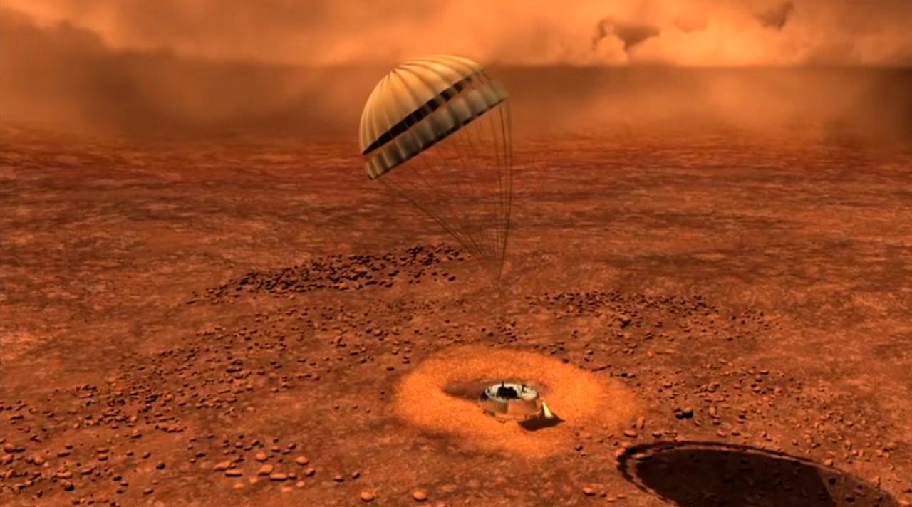
Artist depiction of Huygens landing on Titan. Credit: ESA
Twelve years ago today, the Huygens probe landed on Titan, marking the farthest point from Earth any spacecraft has ever landed. While a twelfth anniversary may be an odd number to mark with a special article, as we said in our previous article (with footage from the landing), this is the last opportunity to celebrate the success of Huygens before its partner spacecraft Cassini ends its mission on September 15, 2017 with a fateful plunge into Saturn’s atmosphere.
But Huygens is also worth celebrating because, amazingly, the mission almost failed, but yet was a marvelous success. If not for the insistence of one ESA engineer to complete an in-flight test of Huygens’ radio system, none of the spacecraft’s incredible data from Saturn’s largest and mysterious moon would have ever been received, and likely, no one would have ever known why.
The first-ever images of the surface Titan, taken by the Huygens probe. Image Credit: ESA/NASA/JPL/University of Arizona
As I detail in my new book “Incredible Stories From Space: A Behind-the-Scenes-Look at the Missions Changing Our View of the Cosmos,” in 1999, the Cassini orbiter and the piggybacking Huygens lander were on their way to the Saturn system. The duo launched in 1997, but instead of making a beeline for the 6th planet from the Sun, they took a looping path called the VVEJGA trajectory (Venus-Venus-Earth-Jupiter Gravity Assist), swinging around Venus twice and flying past Earth 2 years later.
While all the flybys gave the spacecraft added boosts to help get it to Saturn, the Earth flyby also provided a chance for the teams to test out various systems and instruments and get immediate feedback.
“The European group wanted to test the Huygens receiver by transmitting the data from Earth,” said Earl Maize, Project Manager for the Cassini mission at JPL, who I interviewed for the book. “That’s a great in-flight test, because there’s the old adage of flight engineers, ‘test as you fly, fly as you test.’”
The way the Huygens mission would work at the Saturn system was that Cassini would release Huygens when the duo approached Titan. Huygens would drop through Titan’s thick and obscuring atmosphere like a skydiver on a parachute, transmitting data all the while. The Huygens probe didn’t have enough power or a large enough dish to transmit all its data directly to Earth, so Cassini would gather and store Huygens’ data on board and later transmit it to Earth.
Boris Smeds was head of ESOC’s Systems and Requirements Section, Darmstadt, Germany. Credit: ESA.
ESA engineer Boris Smeds wanted to ensure this data handoff was going to work, otherwise a crucial part of the mission would be lost. So he proposed a test during the 1999 Earth flyby.
Maize said that for some reason, there was quite a bit of opposition to the test from some of the ESA officials, but Smeds and Claudio Sollazzo, Huygens’s ground operations manager at ESA’s European Space Operation Centre (ESOC) in Darmstadt, Germany were insistent the test was necessary.
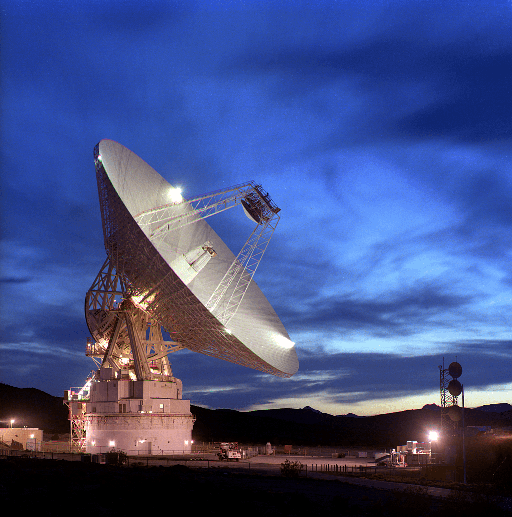
NASA’s Deep Space Network is responsible for communicating with spacecraft. Pictured is the Goldstone facility in California, one of three facilities that make up the Network. Image: NASA/JPL
“They were not to be denied,” Maize said, “so they eventually got permission for the test. The Cassini team organized it, going to the Goldstone tracking station [in California] of the Deep Space Network (DSN) and did what’s called a ‘suitcase test,’ broke into the signal, and during the Earth flyby, Huygens, Cassini and Goldstone were all programmed to simulate the probe descending to Titan. It all worked great.”
Except for one thing: Cassini received almost no simulated data, and what it did receive was garbled. No one could figure out why.
Six months of painstaking investigation finally identified the problem. The variation in speed between the two spacecraft hadn’t been properly compensated for, causing a communication problem. It was as if the spacecraft were each communicating on a different frequency.
Artist concept of the Huygens probe descending to Titan. Credit: ESA.
“The European team came to us and said we didn’t have a mission,” Maize said. “But we put together ‘Tiger Teams’ to try and figure it out.”
The short answer was that the idiosyncrasies in the communications system were hardwired in. With the spacecraft now millions of miles away, nothing could be fixed. But engineers came up with an ingenious solution using a basic principal known as the Doppler Effect.
The metaphor Maize likes to use is this: if you are sitting on the shore and a speed boat goes by close to the coast, it zooms past you quickly. But that same boat going the same speed out on the horizon looks like it is barely moving.
“Since we couldn’t change Huygens’ signal, the only thing we could change was the way Cassini flew,” Maize said. “If we could move Cassini farther away and make it appear as if Huygens was moving slower, it would receive lander’s radio waves at a lower frequency, solving the problem.”
Maize said it took two years of “fancy coding modifications and some pretty amazing trajectory computations.” Huygens’ landing was also delayed two months for the new trajectory that was needed overcome the radio system design flaw.
Additionally, with Cassini needing to be farther away from Huygens than originally planned, it would eventually fly out of range to capture all of Huygens’ data. Astronomers instigated a plan where radio telescopes around the world would listen for Huygens’ faint signals and capture anything Cassini missed.
Huygens was released from the Cassini spacecraft on Christmas Day 2004, and arrived at Titan on January 14, 2005. The probe began transmitting data to Cassini four minutes into its descent through Titan’s murky atmosphere, snapping photos and taking data all the while. Then it touched down, the first time a probe had landed on an extraterrestrial world in the outer Solar System.
Because of the communication problem, Huygens was not able to gather as much information as originally planned, as it could only transmit on one channel instead of two. But amazingly, Cassini captured absolutely all the data sent by Huygens until it flew out of range.
“It was beautiful,” Maize said, “I’ll never forget it. We got it all, and it was a wonderful example of international cooperation. The fact that 19 countries could get everything coordinated and launched in the first place was pretty amazing, but there’s nothing that compares to the worldwide effort we put into recovering the Huygens mission. From an engineering standpoint, that might trump everything else we’ve done on this mission.”
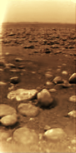
The view of Titan from the descending Huygens spacecraft on January 14, 2005. Credit: ESA/NASA/JPL/University of Arizona.
With its ground-breaking mission, Huygens provided the first real view of the surface of Titan. The data has been invaluable for understanding this unique and mysterious moon, showing geological and meteorological processes that are more similar to those on the surface of the Earth than anywhere else in the Solar System. ESA has details on the top discoveries by Huygens here.
Noted space journalist Jim Oberg has written several detailed and very interesting articles about the Huygens’ recovery, including one at IEEE Spectrum and another at The Space Review. These articles provide much more insight into the test, Smeds’ remarkable insistence for the test, the recovery work that was done and the subsequent success of the mission.
As Oberg says in IEEE Spectrum, “Smeds continued a glorious engineering tradition of rescuing deep-space missions from doom with sheer persistence, insight, and lots of improvisation.”
A modest Smeds was quoted by ESA: “This has happened before. Almost any mission has some design problem,” says Smeds, who says he’s worked on recovering from pre- and post-launch telecom issues that have arisen with several past missions. “To me, it’s just part of my normal work.”
For more stories about Huygens, Cassini and several other current robotic space missions, “Incredible Stories From Space” tells many behind-the-scenes stories from the amazing people who work on these missions.
SpaceX Falcon 9 poised for Jan. 14, 2017, Return to Flight launch from Vandenberg Air Force Base in California carrying ten Iridium NEXT comsats to orbit. Credit: SpaceX
SpaceX Falcon 9 poised for Jan. 14, 2017, Return to Flight launch from Vandenberg Air Force Base in California carrying ten Iridium NEXT comsats to orbit. Credit: SpaceX
Barely four and a half months after another Falcon 9 and its $200 million Israeli commercial payload were suddenly destroyed during a prelaunch fueling test on the Florida Space Coast on Sept. 1, 2016, SpaceX says all systems are GO for the ‘Return to Flight’ launch of a new Falcon 9 on the Iridium-1 mission from the California coast tomorrow.
Another launch failure would deal a devastating blow to confidence in SpaceX’s hard won reputation – so ‘Failure is Not an Option’ as they say in the space business.
The Sept. 1, 2016 calamity was the second Falcon 9 failure within 15 months time. Both occurred inside the second stage and called into question the rockets reliability.
The 229-foot (70-meter) Falcon 9 rocket has been rolled out from its processing hangar to the launch pad and raised vertically.
“Beautiful picture of our ride to space tomorrow on the launch pad this morning!” tweeted Matt Desch, Iridium Communications CEO, featuring the lead photo in this story.
A license for permission to proceed with the launch originally last Sunday was only granted by the FAA last Friday, Jan. 6. But poor California weather in the form of stormy rains and high winds forced further delays to Saturday.
Today, Friday the 13th, it’s T-Minus 1 Day to the inaugural launch of the advanced Iridium NEXT voice and data relay satellites.
Liftoff of the SpaceX Falcon 9 with the payload of 10 identical next generation Iridium NEXT communications satellites is slated for 9:54:39 am PST or 5:54:39 pm UTC from Space Launch Complex 4E on Vandenberg Air Force Base in California.
The Iridium 1 mission only has an instantaneous launch opportunity precisely at 9:54:34 a.m. PST or 12:54:34 p.m. EST.
You can watch the launch live via a SpaceX webcast starting about 20 minutes prior to the planned liftoff time:
Weather forecasters currently predict about a 60 percent chance of favorable conditions at launch time.
Sunday, Jan. 15 is available as a back-up launch opportunity in case of a delay for any reason including technical and weather related issues.
The Iridium NEXT payload has been secured to the SpaceX Falcon 9 rocket at T-2 days to launch. Credit: SpaceX/Iridium
“The teams from Iridium, SpaceX and our partners are in the homestretch for the first launch of the Iridium NEXT satellite constellation,” said satellite owner Iridium Communications.
Meanwhile the launch teams have completed the countdown dress rehearsal’ and Launch Readiness Review in anticipation of the morning liftoff.
“Final preparations are being made for tomorrow’s inaugural launch, and with that comes a number of high-stakes verifications, involving all parties. Traditionally referred to as the ‘countdown dress rehearsal’ and ‘Launch Readiness Review’ (LRR), these milestones represent the final hurdles to clearing the path for the January 14th launch.”
“The countdown dress rehearsal and LRR include several prelaunch inspections and quality control measures. These include final clearances for the SpaceX Falcon 9 rocket, Iridium NEXT payload, SpaceX and Iridium® ground infrastructure and associated team member responsibilities.”
Iridium says that every precaution has been taken to ensure a successful launch.
“There are so many variables that need to be considered when finalizing launch preparations, and a slight deviation or unexpected behavior by any of them can jeopardize the launch integrity,” said Iridium COO Scott Smith, in a statement.
“We’ve perfected the necessary procedures, taken every precaution we can imagine, and tomorrow, after what has felt like centuries, we’ll take the first step on a long-awaited journey to revolutionize satellite communications. The success of today’s events has brought us to an apex moment.”
IridiumNEXT satellites being fueled, pressurized & stacked on dispenser tiers at Vandenberg AFB for Falcon 9 launch. Credit: Iridium
Iridium 1 is the first of seven planned Falcon 9 launches to establish the Iridium NEXT constellation which will eventually consist of 81 advanced satellites.
At least 70 will be launched by SpaceX.
The inaugural launch of the advanced Iridium NEXT satellites will start the process of replacing an aging Iridium fleet in orbit for nearly two decades.
Mission patch for Iridium-1 mission showing launch of the first 10 Iridium NEXT voice and data relay satellites on SpaceX Falcon 9 from Vandenberg Air Force Base, California, for Iridium Communications, and planned landing of the first stage on a droneship in the Pacific Ocean. Credit: SpaceX/Iridium
After the Sept .1 calamity SpaceX conducted a four month long investigation seeking to determine the root cause.
And it was just last Friday, Jan. 6, that the FAA finally granted SpaceX a license to launch the ‘Return to Flight’ Falcon 9 mission – as I confirmed with the FAA.
“The FAA accepted the investigation report on the AMOS-6 mishap and has closed the investigation,” FAA spokesman Hank Price confirmed to Universe Today.
“SpaceX applied for a license to launch the Iridium NEXT satellites from Vandenberg Air Force Base. The FAA has granted a license for that purpose.”
The SpaceX investigation report into the total loss of the Falcon 9 rocket and AMOS-6 payload has not been released at this time. The FAA has oversight responsibility to encourage, facilitate, and promote U.S. commercial space transportation and ensure the protection of public safety.
Incredible sight of pleasure craft zooming past SpaceX Falcon 9 booster from Thaicom-8 launch on May 27, 2016 as it arrives at the mouth of Port Canaveral, FL, atop droneship platform on June 2, 2016. Credit: Ken Kremer/kenkremer.com
In addition to the launch, SpaceX plans to continue its secondary objective of recovering the Falcon 9 first stage via a propulsive soft landing – as done several times previously and witnessed by this author.
The Iridium-1 mission patch featured herein highlights both the launch and landing objectives.
The goal is to eventually recycle and reuse the first stage – and thereby dramatically slash launch costs per Musk’s vision.
This Falcon 9 has been outfitted with four landing legs and grid fins for a controlled landing on a tiny barge prepositioned in the Pacific Ocean several hundred miles off the west coast of California.
Watch this space for continuing updates on SpaceX.
Stay tuned here for Ken’s continuing Earth and Planetary science and human spaceflight news.
The view of Titan from the descending Huygens spacecraft on January 14, 2005. Credit: ESA/NASA/JPL/University of Arizona.
On December 25, 2004, the piggybacking Huygens probe was released from the ‘mothership’ Cassini spacecraft and it arrived at Titan on January 14, 2005. The probe began transmitting data to Cassini four minutes into its descent through Titan’s murky atmosphere, snapping photos and taking data all the while. Then it touched down, the first time a probe had landed on an extraterrestrial world in the outer Solar System.
JPL has released a re-mix of the data and images gathered by Huygens 12 years ago in a beautiful new video. This is the last opportunity to celebrate the success of Huygens before Cassini ends its mission in September of 2017.
Watch as the incredible view of Titan’s surface comes into view, with mountains, a system of river channels and a possible lakebed.
After a two-and-a-half-hour descent, the metallic, saucer-shaped spacecraft came to rest with a thud on a dark floodplain covered in cobbles of water ice, in temperatures hundreds of degrees below freezing.
Huygens had to quickly collect and transmit all the images and data it could because shortly after landing, Cassini would drop below the local horizon, “cutting off its link to the home world and silencing its voice forever.”
How much of this video is actual images and data vs computer graphics?
Of course, the clips at the beginning and end of the video are obviously animations of the probe and orbiter. However, the slow descending 1st-person point-of-view video is made using actual images from Huygens. But Huygens did not take a continuous movie sequence, so a lot of work was done by the team that operated Huygens’ optical imager, the Descent Imager/Spectral Radiometer (DISR), to enhance, colorize, and re-project the images into a variety of formats.
The view of the cobblestones and the parachute shadow near the end of the video is also created from real landing data, but was made in a different way from the rest of the descent video, because Huygens’ cameras did not actually image the parachute shadow. However, the upward looking infrared spectrometer took a measurement of the sky every couple of seconds, recording a darkening and then brightening to the unobstructed sky. The DISR team calculated from this the accurate speed and direction of the parachute, and of its shadow to create a very realistic video based on the data.
If you’re a data geek, there are some great videos of Huygens’ data by the University of Arizona Lunar and Planetary Laboratory team, such as this one:
The movie shows the operation of the DISR camera during the descent onto Titan. The almost 4-hour long operation
of DISR is shown in less than five minutes in 40 times actual sped up to landing and 100 times actual speed thereafter.
Erich Karkoschka from the UA team explained what all the sounds in the video are. “All parts of DISR worked together as programmed, creating a harmony,” he said. Here’s the full explanation:
Sound was added to mark various events. The left speaker follows the motion of Huygens. The pitch of the tone indicates the rotational speed. Vibrato indicates vibration of the parachute. Little clicks indicate the clocking of the rotation counter. Noise corresponds to heating of the heat shield, to parachute deployments, to the heat shield release, to the jettison of the DISR cover, and to touch down.
The sound in the right speaker follows DISR data. The pitch of the continuous tone goes with the signal strength. The 13 different chime tones indicate activity of the 13 components of DISR. The counters at the top and bottom of the list get the high and low notes, respectively.
You can see more info and videos created from Huygens’ data here.