Copyright: ESA with changes to annotations by the author
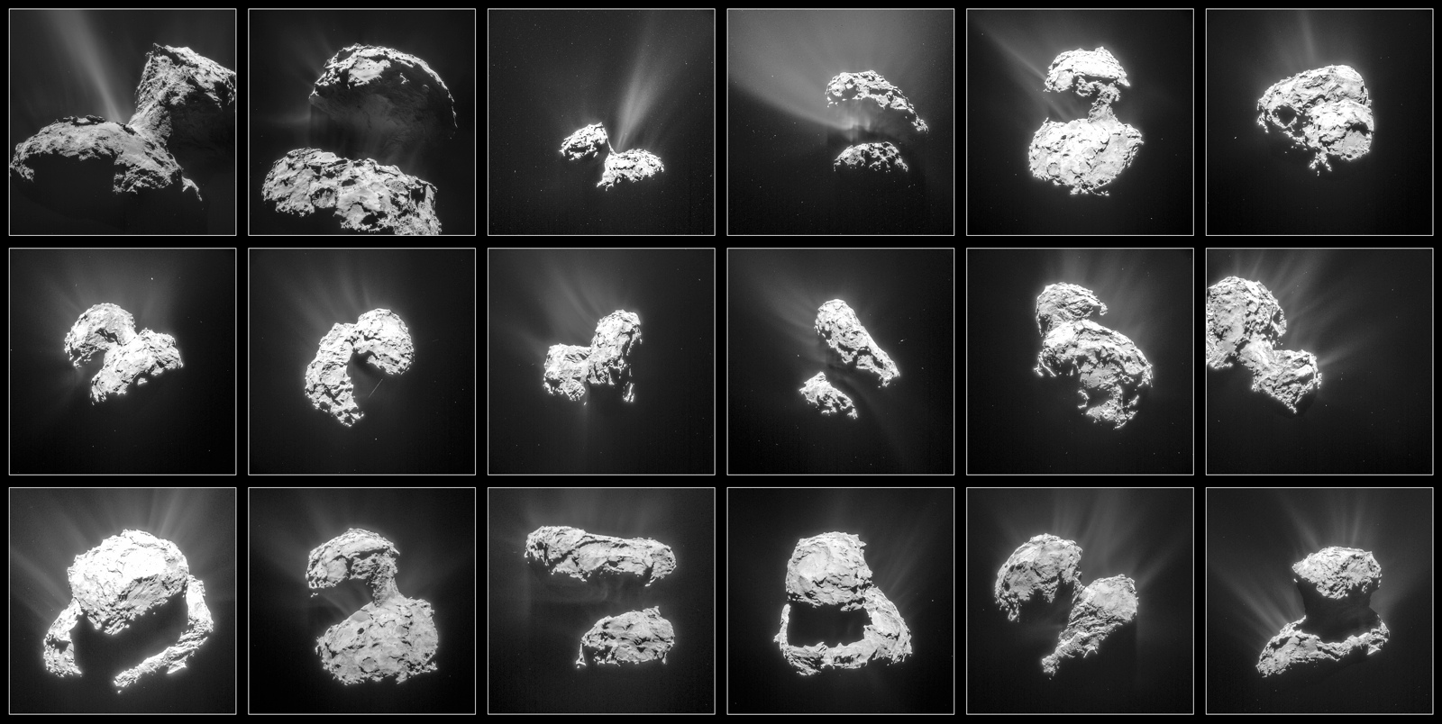
This montage of photos of Comet 67P/Churyumov-Gerasimenko was taken by ESA’s Rosetta spacecraft between Jan. 31 and March 25, 2015 and shows increasing activity as the comet approached perihelion. Credit: NAVCAM /CC-BY-SA-IGO-3.0
Rosetta awoke from a decade of deep-space hibernation in January 2014 and immediately got to work photographing, measuring and sampling comet 67P/C-G. On September 30 it will sleep again but this time for eternity. Mission controllers will direct the probe to impact the comet’s dusty-icy nucleus within 20 minutes of 10:40 Greenwich Time (6:40 a.m. EDT) that Friday morning. The high-resolution OSIRIS camera will be snapping pictures on the way down, but once impact occurs, it’s game over, lights out. Rosetta will power down and go silent.
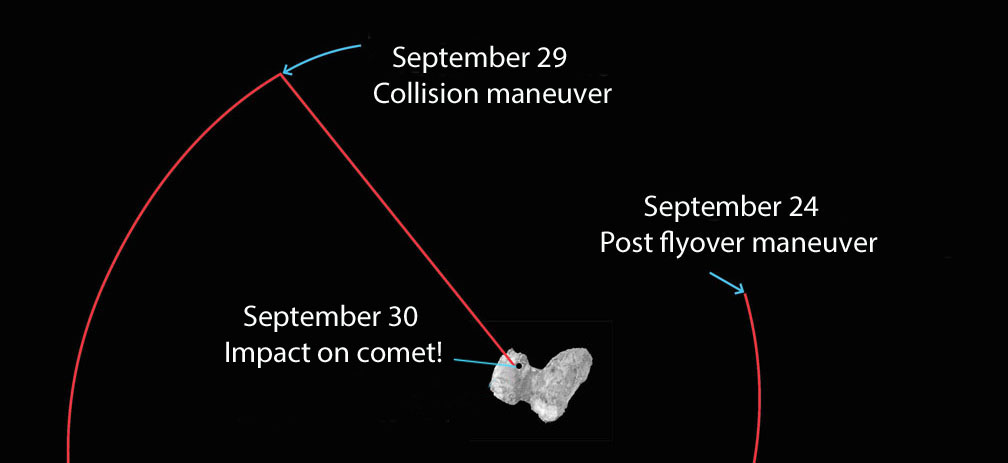
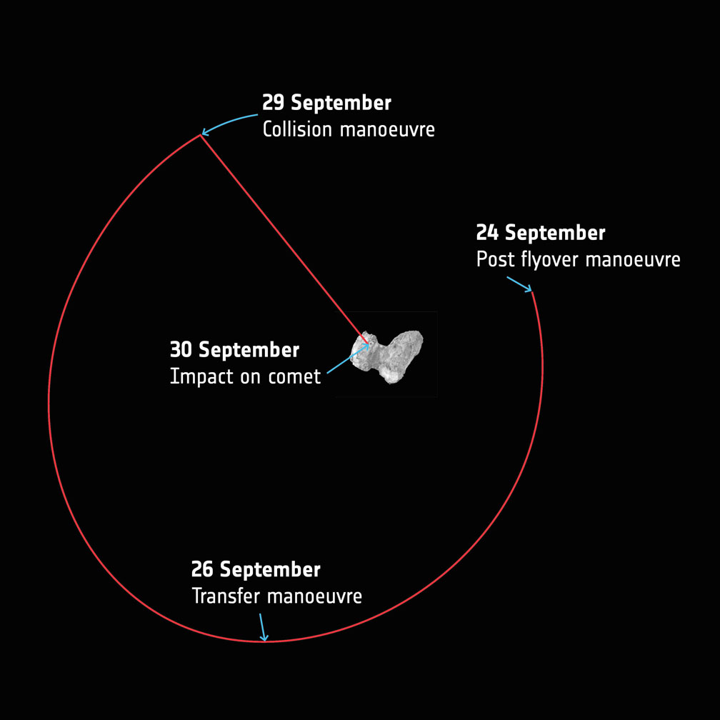
A simplified overview of Rosetta’s last week of maneuvers at Comet 67P/Churyumov–Gerasimenko. Starting today (Sept. 24) the spacecraft will leave the flyover orbits and transfer towards a 16 x 23 km orbit that will be used to prepare for the final descent. The collision course maneuver will take place in the evening Sept. 29 with impact expected to occur at 10:40 GMT (6:40 a.m. EDT), which taking into account the 40 minute signal travel time between Rosetta and Earth on Sept. 30, means the confirmation would be expected at mission control at 11:20 GMT (7:20 a.m. EDT). Copyright: ESA
Nearly three years have passed since Rosetta opened its eyes on 67P, this curious, bi-lobed rubber duck of a comet just 2.5 miles (4 km) across with landscapes ranging from dust dunes to craggy peaks to enigmatic ‘goosebumps’. The mission was the first to orbit a comet and dispatch a probe, Philae, to its surface. I think it’s safe to say we learned more about what makes comets tick during Rosetta’s sojourn than in any previous mission.
So why end it? One of the big reasons is power. As Rosetta races farther and farther from the Sun, less sunlight falls on its pair of 16-meter-long solar arrays. At mid-month, the probe was over 348 million miles (560 million km) from the Sun and 433 million miles (697 million km) from Earth or nearly as far as Jupiter. With Sun-to-Rosetta mileage increasing nearly 620,000 miles (1 million km) a day, weakening sunlight can’t provide the power needed to keep the instruments running.
Rosetta’s last orbits around the comet
Rosetta’s also showing signs of age after having been in the harsh environment of interplanetary space for more than 12 years, two of them next door to a dust-spitting comet. Both factors contributed to the decision to end the mission rather than put the probe back into an even longer hibernation until the comet’s next perihelion many years away.
Since August 9, Rosetta has been swinging past the comet in a series of ever-tightening loops, providing excellent opportunities for close-up science observations. On September 5, Rosetta swooped within 1.2 miles (1.9 km) of 67P/C-G’s surface. It was hoped the spacecraft would descend as low as a kilometer during one of the later orbits as scientists worked to glean as much as possible before the show ends.
Rosetta is targeted to land at the site within this planned impact ellipse in the Ma’at region on the comet’s smaller lobe. See below for a closer view. Credit: ESA/Rosetta/NAVCAM – CC BY-SA IGO 3.0
The final of 15 close flyovers will be completed today (Sept. 24) after which Rosetta will be maneuvered from its current elliptical orbit onto a trajectory that will eventually take it down to the comet’s surface on Sept. 30.
The beginning of the end unfolds on the evening of the 29th when Rosetta spends 14 hours free-falling slowly towards the comet from an altitude of 12.4 miles (20 km) — about 4 miles higher than a typical commercial jet — all the while collecting measurements and photos that will be returned to Earth before impact. The last eye-popping images will be taken from a distance of just tens to a hundred meters away.
The landing will be a soft one, with the spacecraft touching down at walking speed. Like Philae before it, it will probably bounce around before settling into place. Mission control expects parts of the probe to break upon impact.
Taking into account the additional 40 minute signal travel time between Rosetta and Earth on the 30th, confirmation of impact is expected at ESA’s mission control in Darmstadt, Germany, within 20 minutes of 11:20 GMT (7:20 a.m. EDT). The times will be updated as the trajectory is refined. You can watch live coverage of Rosetta’s final hours on ESA TV.
ESAHangout: Preparing for Rosetta’s grand finale
“It’s hard to believe that Rosetta’s incredible 12.5 year odyssey is almost over, and we’re planning the final set of science operations, but we are certainly looking forward to focusing on analyzing the reams of data for many decades to come,” said Matt Taylor, ESA’s Rosetta project scientist.
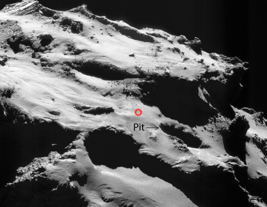
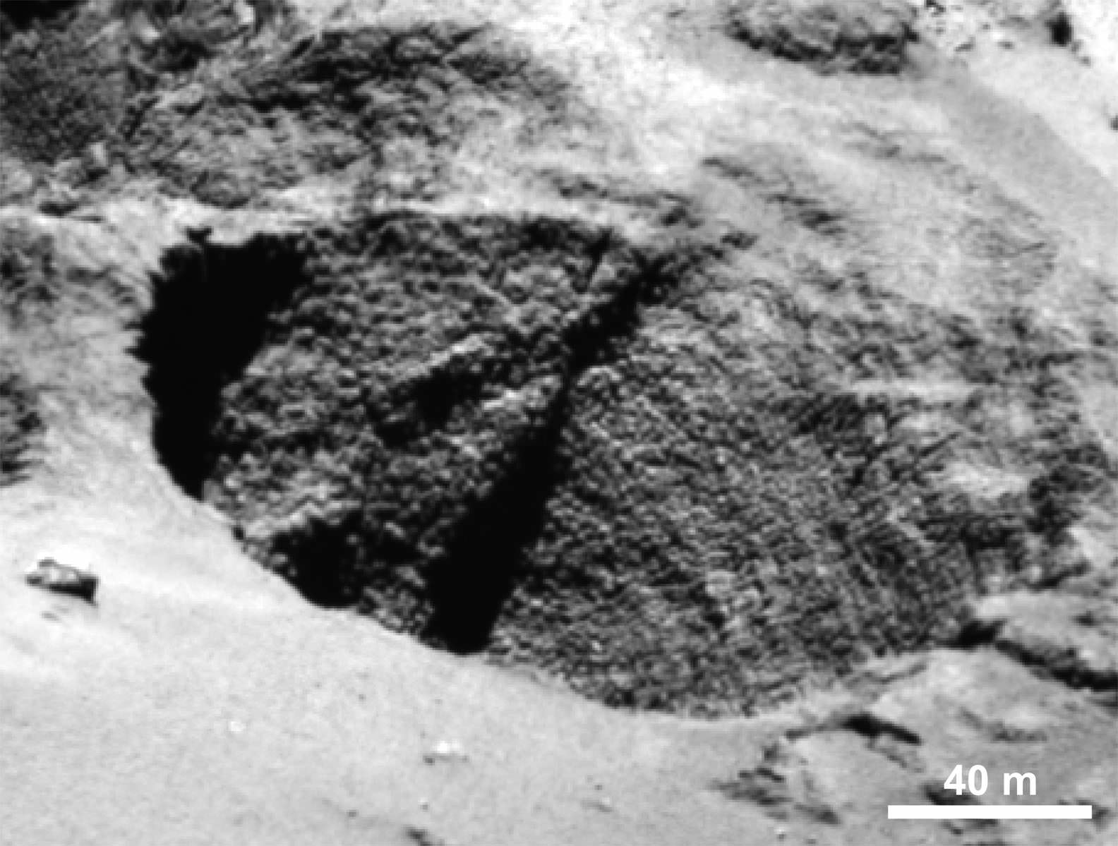
The spacecraft landing site is shown in red and located next to Deir el-Medina, a large pit (arrowed). Credit: ESA/Rosetta/NAVCAM – CC BY-SA IGO 3.0
Plans call for the spacecraft to impact the comet somewhere within an ellipse about 1,300 x 2,000 feet (600 x 400 meters) long on 67P’s smaller lobe in the region known as Ma’at. It’s home to several active pits more than 328 feet (100 meters) in diameter and 160-200 feet (50-60 meters) deep, where a number of the comet’s dust jets originate. The walls of the pits are lined with fascinating meter-sized lumpy structures called ‘goosebumps’, which scientists believe could be early ‘cometesimals’, the icy snowballs that stuck together to create the comet in the early days of our Solar System’s formation.
Close-up of a curious surface texture nicknamed ‘goosebumps’. The bumps are about 9 feet (3 meters) across and seen on very steep slopes and exposed cliff faces. They may represent the original balls of icy dust that glommed together to form comets 4.5 billion years ago. Credit: ESA/Rosetta/MPS for OSIRIS Team MPS/UPD/LAM/IAA/SSO/INTA/UPM/DASP/IDA
During free-fall, the spacecraft will target a point adjacent to a 425-foot (130 m) wide, well-defined pit that the mission team has informally named Deir el-Medina, after a structure with a similar appearance in an ancient Egyptian town of the same name. High resolution images should give us a spectacular view of these enigmatic bumps.
While we hate to see Rosetta’s mission end, it’s been a blast going for a 2-year-plus comet ride-along.
NASA has unveiled a new exercise device that will be used by Orion crews to stay healthy on their mission to Mars. Credit: NASA
On Sept. 15th, the Senate Committee on Commerce, Science, and Transportation met to consider legislation formally introduced by a bipartisan group of senators. Among the bills presented was the NASA Transition Authorization Act of 2016, a measure designed to ensure short-term stability for the agency in the coming year.
And as of Thursday, Sept. 22nd, the Senate Commerce Committee approved the bill, providing $19.5 billion in funding for NASA for fiscal year 2017. This funding was intended for the purpose of advancing the agency’s plans for deep space exploration, the Journey to Mars, and operations aboard the International Space Station.
According to Senator Ted Cruz, the bill’s lead sponsor, the Act was introduced in order to ensure that NASA’s major programs would be stable during the upcoming presidential transition. As Cruz was quoted as saying by SpaceNews:
“The last NASA reauthorization act to pass Congress was in 2010. And we have seen in the past the importance of stability and predictability in NASA and space exploration: that whenever one has a change in administration, we have seen the chaos that can be caused by the cancellation of major programs.”
Graphic shows Block I configuration of NASA’s Space Launch System (SLS). Credits: NASA/MSFC
This last act was known as the “NASA Authorization Act of 2010“, which authorized appropriations for NASA between the years of 2011-2013. In addition to providing a total of $58 billion in funding for those three years, it also defined long-term goals for the space agency, which included expanding human space flight beyond low-Earth orbit and developing technical systems for the “Journey to Mars”.
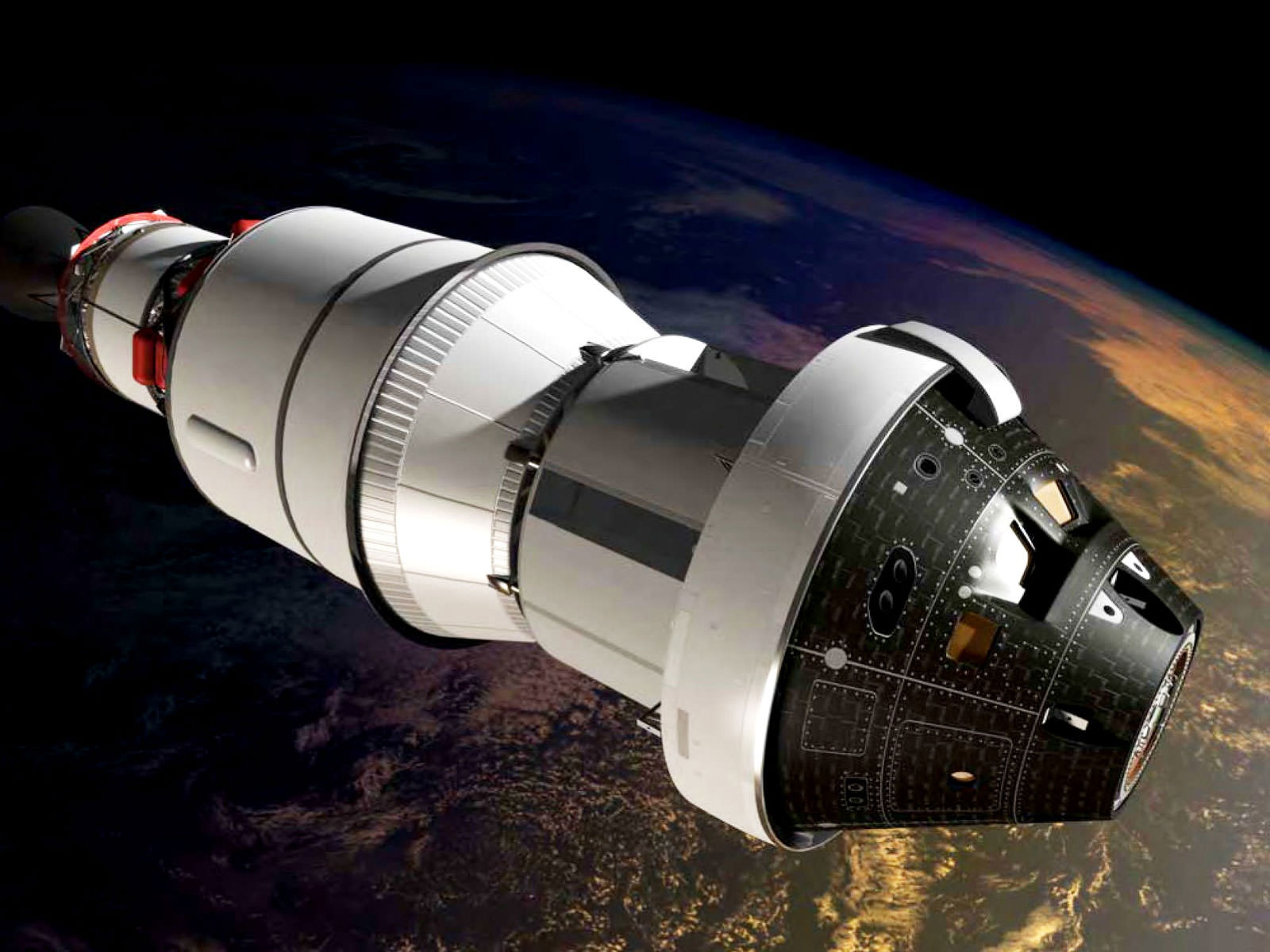
Intrinsic to this was the creation of the Space Launch System (SLS) as a successor to the Space Shuttle Program, the development of the Orion Multipurpose Crew Vehicle, full utilization of the International Space Station, leveraging international partnerships, and encouraging public participation by investing in education.
“In order to maximize the cost-effectiveness of the long-term exploration and utilization activities of the United States, the Administrator shall take all necessary steps, including engaging international, academic, and industry partners to ensure that activities in the Administration’s human exploration program balance how those activities might also help meet the requirements of future exploration and utilization activities leading to human habitation on the surface of Mars.”
NASA has unveiled a new exercise device that will be used by Orion crews to stay healthy on their mission to Mars. Credit: NASA
While the passage of the bill is certainly good news for NASA’s bugeteers, it contains some provisions which could pose problems. For example, while the bill does provide for continued development of the SLS and Orion capsule, it advised that NASA find alternatives for its Asteroid Robotic Redirect Missions (ARRM), which is currently planned for the 2020s.
This mission, which NASA deemed essential for testing key systems and developing expertise for their eventual crewed mission to Mars, was cited for not falling within original budget constraints. Section 435 (“Asteroid Robotic Redirect Mission“), details these concerns, stating that an initial estimate put the cost of the mission at $1.25 billion, excluding launch and operations.
However, according to a Key Decision Point-B review conducted by NASA on July 15th, 2016, a new estimate put the cost at $1.4 billion (excluding launch and operations). As a result, the bill’s sponsors concluded that ARM is in competition with other programs, and that an independent cost assessment and some hard choices may be necessary.
In Section 435, subsection b (parts 1 and 2), its states that:
“[T]he technological and scientific goals of the Asteroid Robotic Redirect Mission may not be commensurate with the cost; and alternative missions may provide a more cost effective and scientifically beneficial means to demonstrate the technologies needed for a human mission to Mars that would otherwise be demonstrated by the Asteroid Robotic Redirect Mission.”
Artist’s impression of NASA’s ARM, which could be threatened by the agency’s new budget. Credit: NASA
The bill was also subject to amendments, which included the approval of funding for the development of satellite servicing technology. Under this arrangement, NASA would have the necessary funds to create spacecraft capable of repairing and providing maintenance to orbiting satellites, thus ensuring long-term functionality.
Also, Cruz and Bill Nelson (D-Fla), the committee ranking member, also supported an amendment that would indemnify companies or third parties executing NASA contracts. In short, companies like SpaceX or Blue Origin would now be entitled to compensation (above a level they are required to insure against) in the event of damages or injuries incurred as a result of launch and reentry services being provided.
According to a Commerce Committee press release, Sen. Bill Nelson had this to say about the bill’s passage:
“I want to thank Chairman Thune and the members of the committee for their continued support of our nation’s space program. Last week marked the 55th anniversary of President Kennedy’s challenge to send a man to the Moon by the end of the decade. The NASA bill we passed today keeps us moving toward a new and even more ambitious goal – sending humans to Mars.”
With the approval of the Commerce Committee, the bill will now be sent to the Senate for approval. It is hoped that the bill will pass through the Senate quickly so it can be passed by the House before the year is over. Its supporters see this as crucial to maintaining NASA’s funding in the coming years, during which time they will be taking several crucial steps towards the proposed crewed mission to Mars.
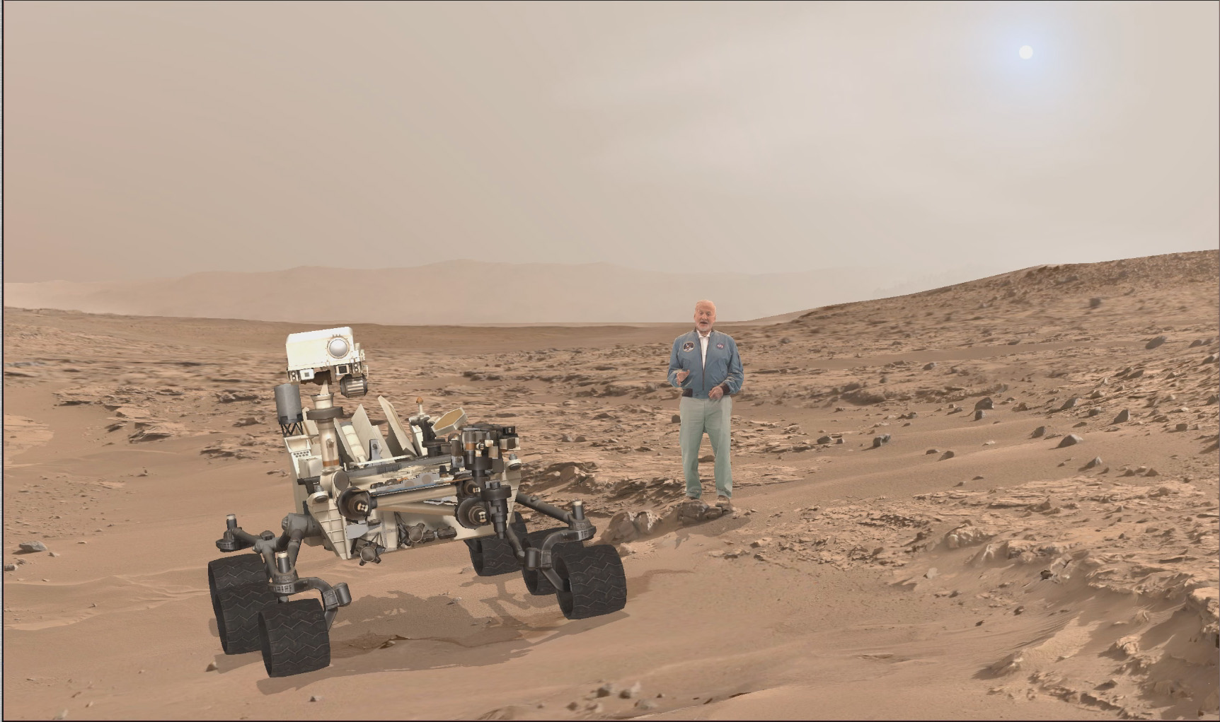
A scene from ‘Destination Mars’ of Buzz Aldrin and NASA’s Curiosity Mars rover with the Gale crater rim in the distance. The new, limited time interactive exhibit is now showing at the Kennedy Space Center visitor complex in Florida through Jan 1, 2017. Credit: NASA/JPL/Microsoft
A scene from ‘Destination Mars’ of Buzz Aldrin and NASA’s Curiosity Mars rover with the Gale crater rim in the distance. The new, limited time interactive exhibit is now showing at the Kennedy Space Center visitor complex in Florida through Jan 1, 2017. Credit: NASA/JPL/Microsoft
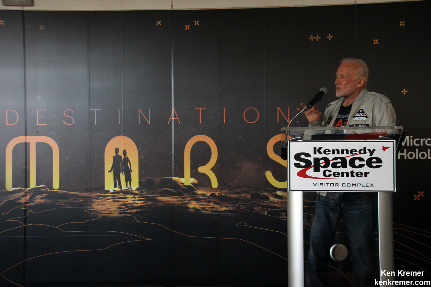
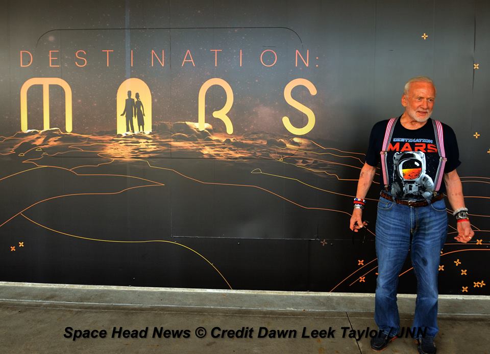
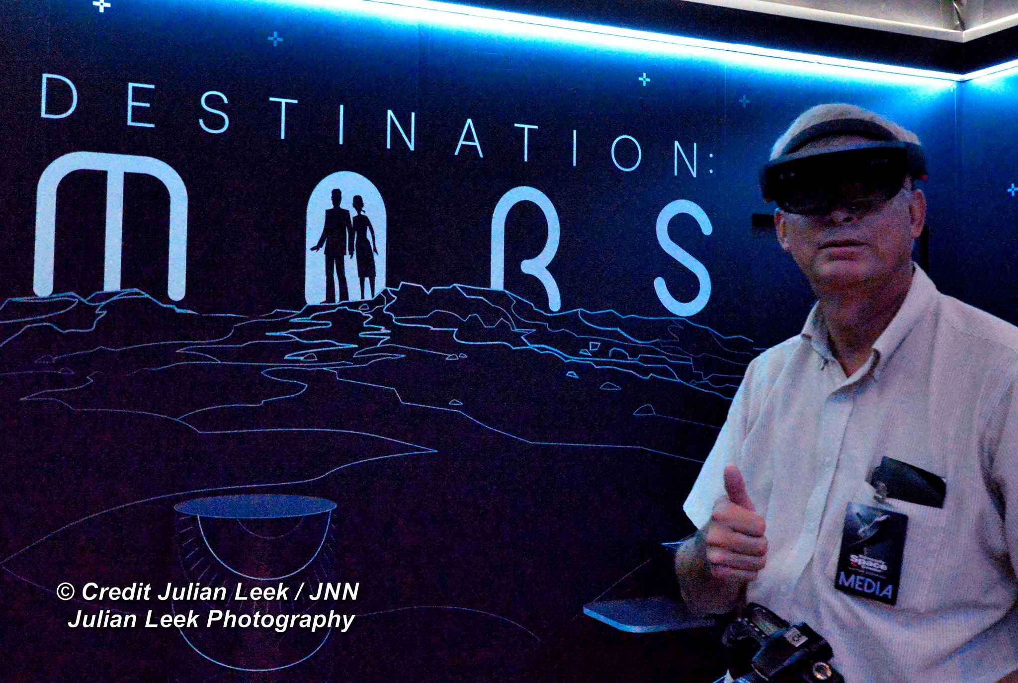
KENNEDY SPACE CENTER VISITOR COMPLEX, FL- Think a Holodeck adventure on Star Trek guided by real life Apollo 11 moonwalker Buzz Aldrin and you’ll get a really good idea of what’s in store for you as you explore the surface of Mars like never before in the immersive new ‘Destination Mars’ interactive holographic exhibit opening to the public today, Monday, Sept.19, at the Kennedy Space Center visitor complex in Florida.
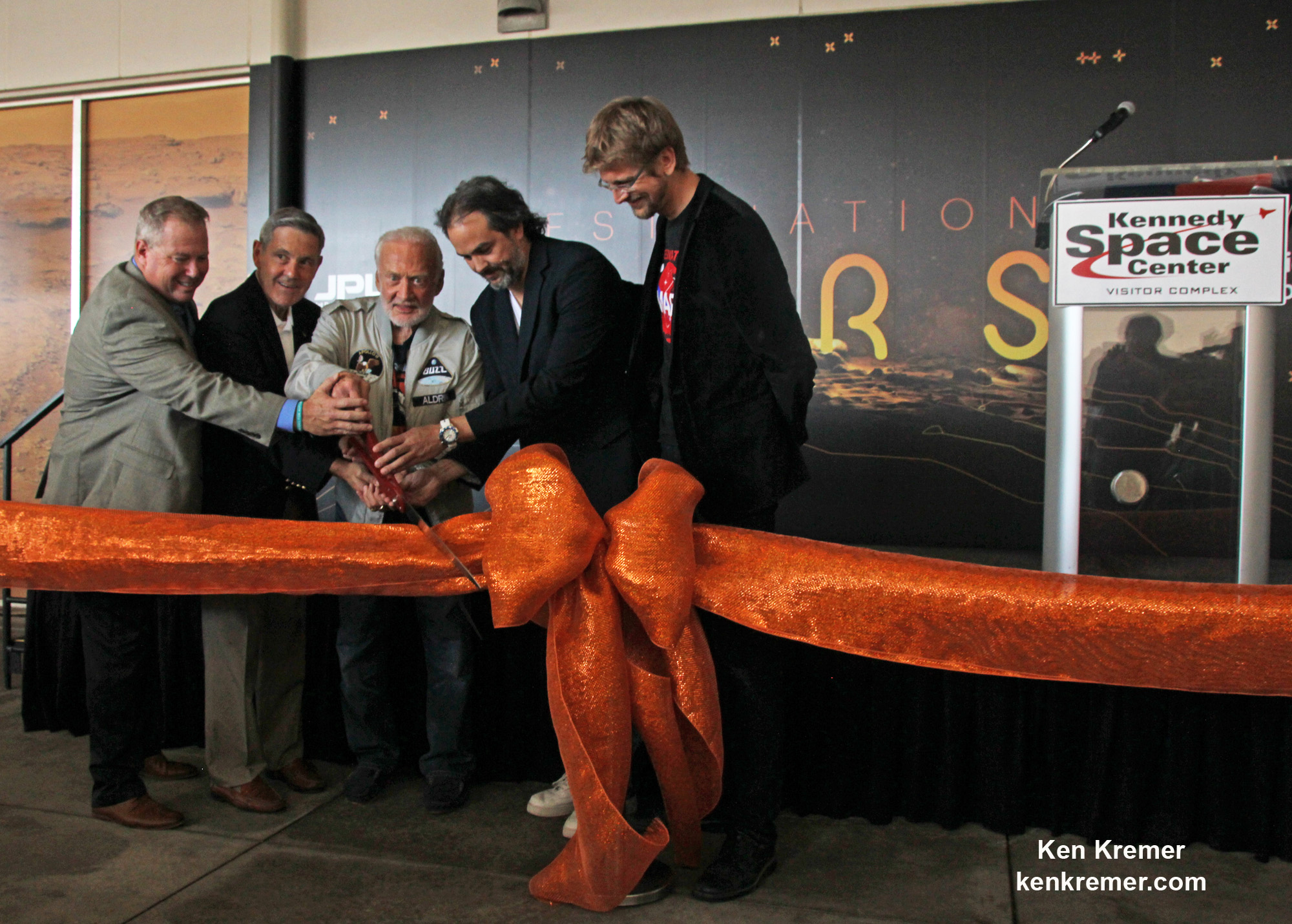
The new Red Planet exhibit was formally opened for business during a very special ribbon cutting ceremony featuring Buzz Aldrin as the star attraction – deftly maneuvering the huge ceremonial scissors during an in depth media preview and briefing on Sunday, Sept. 18, 2016, including Universe Today.
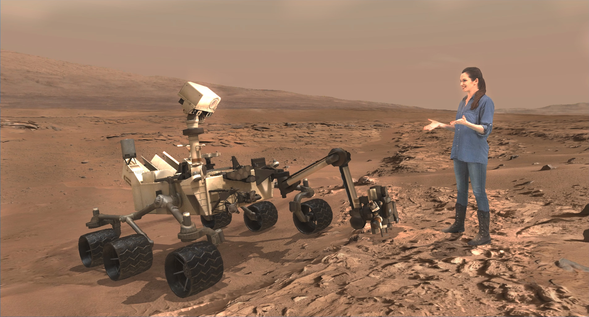
The fabulous new ‘Destination Mars’ limited engagement exhibit magically transports you to the surface of the Red Planet via Microsoft HoloLens technology.
It literally allows you to ‘Walk on Mars’ using real imagery taken by NASA’s Mars Curiosity rover and explore the alien terrain, just like real life scientists on a geology research expedition.
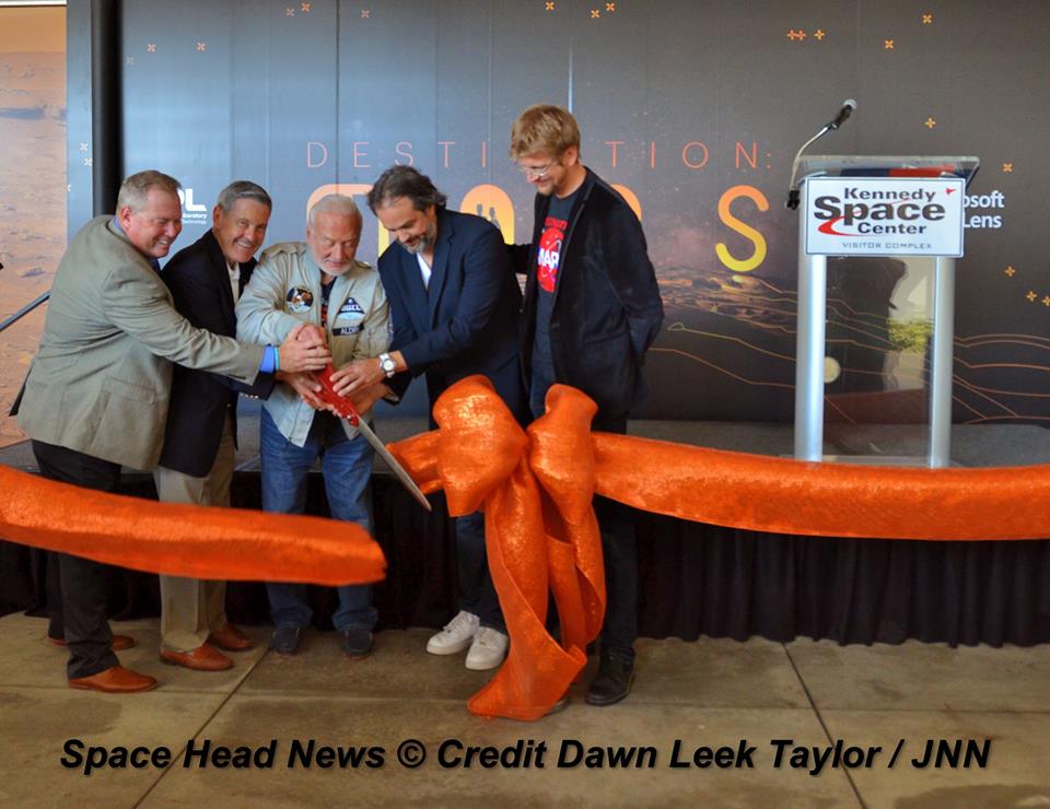
A ceremonial ribbon is cut for the opening of new “Destination: Mars” experience at the Kennedy Space Center visitor complex in Florida during media preview on Sept. 18, 2016. From the left are Therrin Protze, chief operating officer of the visitor complex; center director Bob Cabana; Apollo 11 astronaut Buzz Aldrin; Kudo Tsunoda of Microsoft; and Jeff Norris of NASA’s Jet Propulsion Laboratory in Pasadena, California. Credit: Ken Kremer/kenkremer.com
“Technology like HoloLens leads us once again toward exploration,” Aldrin said during the Sept. 18 media preview. “It’s my hope that experiences like “Destination: Mars” will continue to inspire us to explore.”
Destination Mars was jointly developed by NASA’s Jet Propulsion Laboratory – which manages the Curiosity rover mission for NASA – and Microsoft HoloLens.
A ceremonial ribbon is cut for the opening of new “Destination: Mars” experience at the Kennedy Space Center visitor complex in Florida during media preview on Sept. 18, 2016. From the left are Therrin Protze, chief operating officer of the visitor complex; center director Bob Cabana; Apollo 11 astronaut Buzz Aldrin; Kudo Tsunoda of Microsoft; and Jeff Norris of NASA’s Jet Propulsion Laboratory in Pasadena, California. Credit: Dawn Taylor Leek
Buzz was ably assisted at the grand ribbon cutting ceremony by Bob Cabana, former shuttle commander and current Kennedy Space Center Director, Therrin Protze, chief operating officer of the visitor complex, Kudo Tsunoda of Microsoft, and Jeff Norris of NASA’s Jet Propulsion Laboratory in Pasadena, California.
The experience is housed in a pop-up theater that only runs for the next three and a half months, until New Years Day, January 1, 2017.
Before entering the theater, you will be fitted with specially adjusted HoloLens headsets individually tailored to your eyes.
The entire ‘Destination Mars’ experience only lasts barely 8 minutes.
So, if you are lucky enough to get a ticket inside you’ll need to take advantage of every precious second to scan around from left and right and back, and top to bottom. Be sure to check out Mount Sharp and the rim of Gale Crater.
You’ll even be able to find a real drill hole that Curiosity bored into the Red Planet at Yellowknife Bay about six months after the nailbiting landing in August 2012.
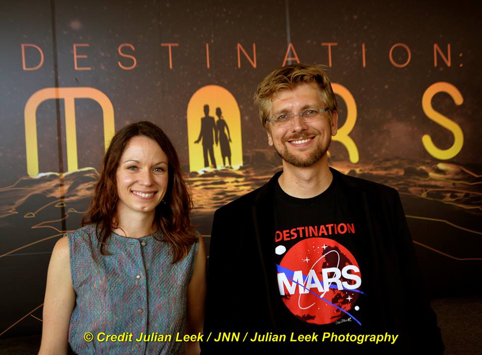
During your experience you will be guided by Buzz and Curiosity rover driver Erisa Hines of JPL. They will lead you to areas of Mars where the science team has made many breakthrough discoveries such as that liquid water once flowed on the floor of Curiosity’s Gale Crater landing site.
Curiosity rover driver Erisa Hines and Jeff Norris of NASA’s Jet Propulsion Laboratory at the grand opening for Destination Mars at the Kennedy Space Center visitor complex in Florida on Sept. 18, 2016. Credit Julian Leek
The scenes come to life based on imagery combining the Mastcam color cameras and the black and white navcam cameras, Jeff Norris of NASA’s Jet Propulsion Laboratory in Pasadena, California, told Universe Today in an interview.
Among the surface features visited is Yellowknife Bay where Curiosity conducted the first interplanetary drilling and sampling on another planet in our Solar System. The sample were subsequently fed to and analyzed by the pair of miniaturized chemistry labs – SAM and CheMin – inside the rovers belly.
They also guide viewers to “a tantalizing glimpse of a future Martian colony.”
“The technology that accomplishes this is called “mixed reality,” where virtual elements are merged with the user’s actual environment, creating a world in which real and virtual objects can interact, “ according to a NASA description.
“The public experience developed out of a JPL-designed tool called OnSight. Using the HoloLens headset, scientists across the world can explore geographic features on Mars and even plan future routes for the Curiosity rover.”
Curiosity is currently exploring the spectacular looking buttes in the Murray Buttes region in lower Mount Sharp. Read my recent update here.
A scene from ‘Destination Mars’ of Erisa Hines and NASA’s Curiosity Mars rover with Mount Sharp Gale crater rim in the distance. The new, limited time interactive exhibit is now showing at the Kennedy Space Center visitor complex in Florida through Jan 1, 2017. Credit: NASA/JPL/Microsoft
Be sure to pay attention or your discovery walk on Mars will be over before you know it. Personally, as a Mars lover and Mars mosaic maker I was thrilled by the 3 D reality and I was ready for more.
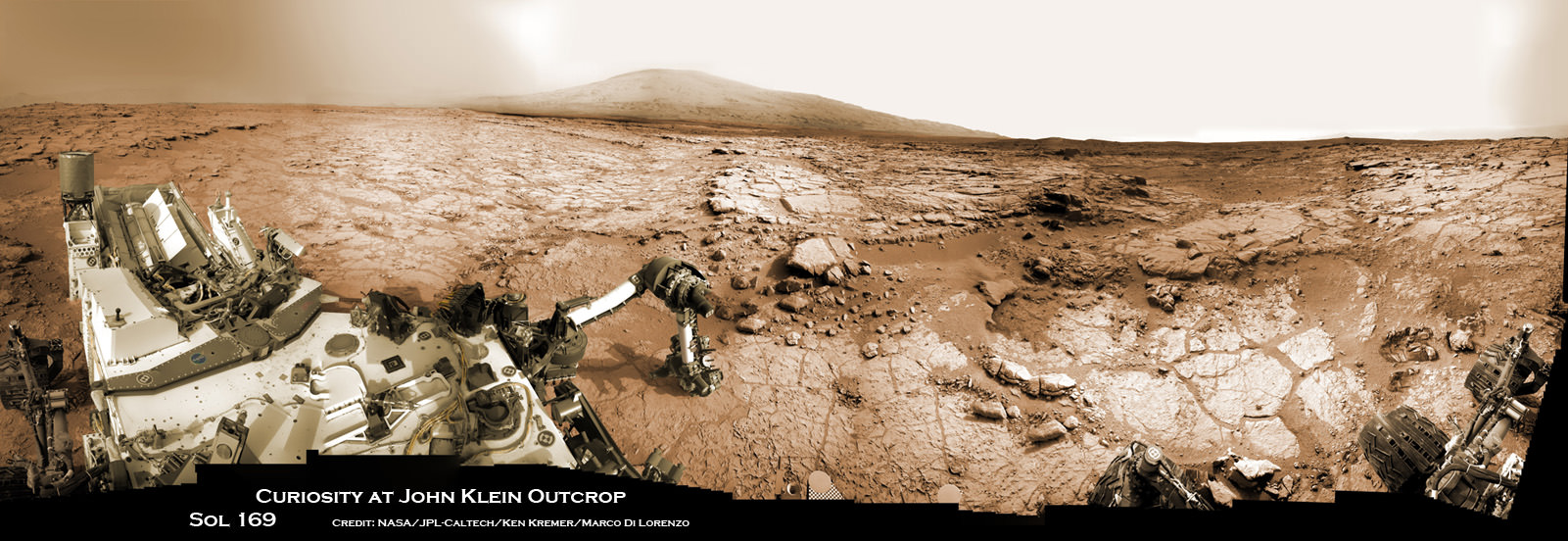
Curiosity accomplished Historic 1st drilling into Martian rock at John Klein outcrop on Feb 8, 2013 (Sol 182) and discovered a habitable zone, shown in this context mosaic view of the Yellowknife Bay basin taken on Jan. 26 (Sol 169). The robotic arm is pressing down on the surface at John Klein outcrop of veined hydrated minerals – dramatically back dropped with her ultimate destination; Mount Sharp. Credit: NASA/JPL-Caltech/Ken Kremer-kenkremer.com/Marco Di Lorenzo
This limited availability, timed experience is available on a first-come, first-served basis. Reservations must be made the day of your visite at the Destination: Mars reservation counter, says the KSC Visitor Complex (KSCVC).
You can get more information or book a visit to Kennedy Space Center Visitor Complex, by clicking on the website link:
Be sure to visit this spectacular holographic exhibit before it closes on New Year’s Day 2017 because it is only showing at KSCVC.
There are no plans to book it at other venues, Norris told me.
Apollo 11 moonwalker Buzz Aldrin describes newly opened ‘Destination Mars’ holographic experience during media preview at the Kennedy Space Center visitor complex in Florida on Sept. 18, 2016. Credit: Ken Kremer/kenkremer.com
As of today, Sol 1465, September 19, 2016, Curiosity has driven over 7.9 miles (12.7 kilometers) since its August 2012 landing inside Gale Crater, and taken over 354,000 amazing images.
Apollo 11 moonwalker Buzz Aldrin during media preview of newly opened ‘Destination Mars’ holographic experience at the Kennedy Space Center visitor complex in Florida on Sept. 18, 2016. Credit Julian Leek
Stay tuned here for Ken’s continuing Earth and planetary science and human spaceflight news.
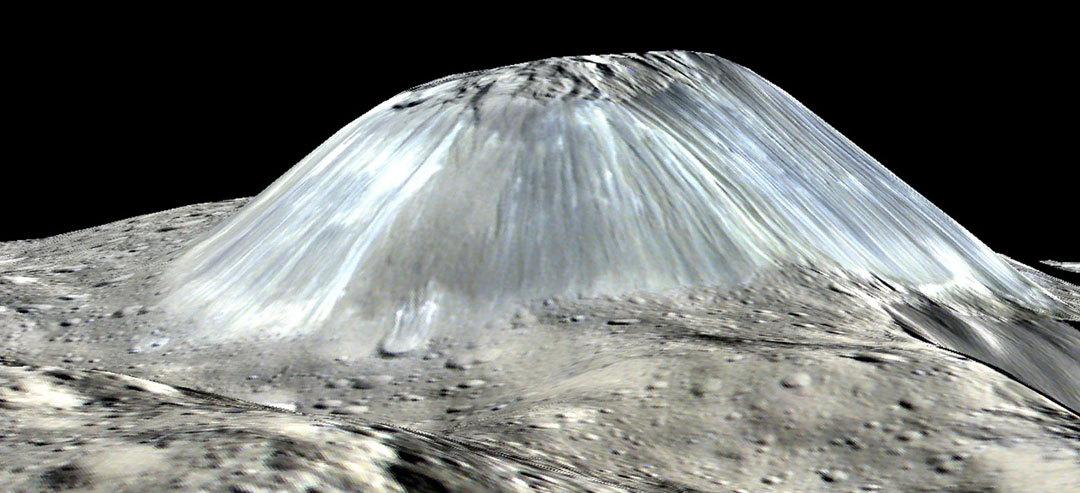
Ahuna Mons towers over the Cerean landscape in this photo taken by the Dawn spacecraft. Credit: NASA/JPL-Caltech/UCLA/MPS/DLR/IDA/PSI
Whoa – what a sight! Ceres’ lonely mountain, Ahuna Mons, is seen in this simulated perspective view. The elevation has been exaggerated by a factor of two. The view was made using enhanced-color images from NASA’s Dawn mission in August from an altitude of 240 miles (385 km) in August 2016. Credit: NASA/JPL-Caltech/UCLA/MPS/DLR/IDA/PSI
An isolated 3-mile-high (5 km) mountain Ahuna Mons on Ceres is likely volcanic in origin, and the dwarf planet may have a weak, temporary atmosphere. These are just two of many new insights about Ceres from NASA’s Dawn mission published this week in six papers in the journal Science.
Ahuna Mons is seen in this mosaic of images from NASA’s Dawn spacecraft. On its steepest side, this mountain is about 3 miles (5 km) high. Its average overall height is 2.5 miles (4 km). The diameter of the mountain is about 12 miles (20 km). Dawn took these images from its low-altitude mapping orbit, 240 miles (385 kilometers) above the surface, in December 2015. Credits: NASA/JPL/Dawn mission
“Dawn has revealed that Ceres is a diverse world that clearly had geological activity in its recent past,” said Chris Russell, principal investigator of the Dawn mission, based at the University of California, Los Angeles.
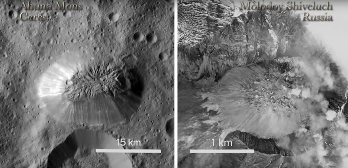
The Ahuna Mons dome compared to a dome in Russia. The similarity in appearance is striking though the difference in size is large. Credit: NASA
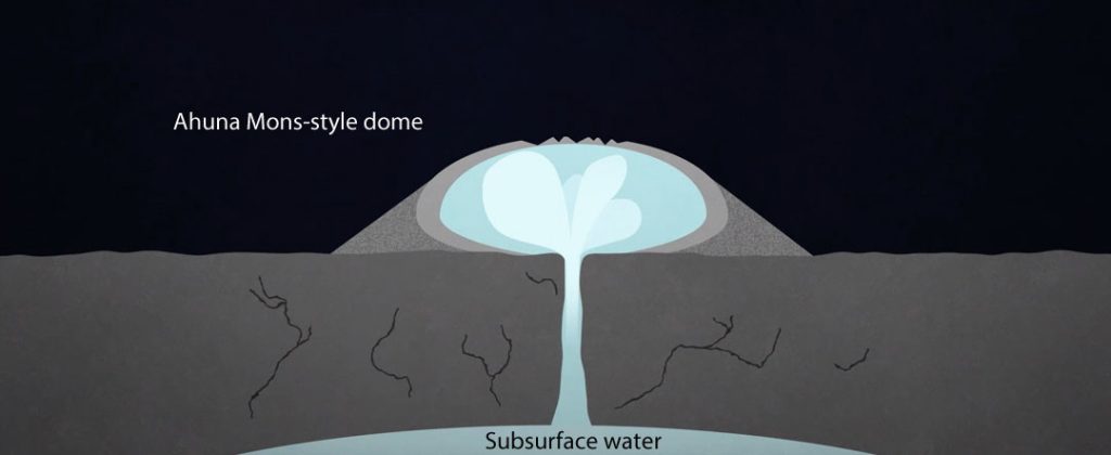
Ahuna Mons is a volcanic dome similar to earthly and lunar volcanic domes but unique in the solar system, according to a new analysis led by Ottaviano Ruesch of NASA’s Goddard Space Flight Center and the Universities Space Research Association. While those on Earth erupt with molten rock, Ceres’ grandest peak likely formed as a salty-mud volcano. Instead of molten rock, salty-mud volcanoes, or “cryovolcanoes,” release frigid, salty water sometimes mixed with mud.
Learn more about Ahuna Mons
“This is the only known example of a cryovolcano that potentially formed from a salty mud mix, and that formed in the geologically recent past,” Ruesch said. Estimates place the mountain formation within the past billion years.
Dawn may also have detected a weak, temporary atmosphere; the probe’s gamma ray and neutron (GRaND) detector observed evidence that Ceres had accelerated electrons from the solar wind to very high energies over a period of about six days. In theory, the interaction between the solar wind’s energetic particles and atmospheric molecules could explain the GRaND observations.
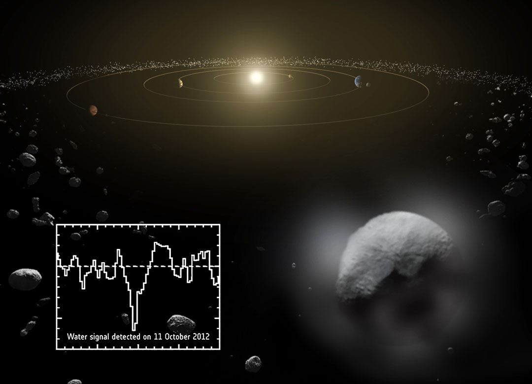
Dwarf planet Ceres is located in the asteroid belt, between the orbits of Mars and Jupiter. Observations by ESA’s Herschel Space Observatory between 2011 and 2013 found that the dwarf planet has a thin water-vapor atmosphere, the first detection ever of water vapor around an asteroid in the asteroid belt. Copyright ESA/ATG medialab/Küppers et al.
A temporary atmosphere would confirm the water vapor the Herschel Space Observatory detected at Ceres in 2012-2013. The electrons that GRaND detected could have been produced by the solar wind hitting the water molecules that Herschel observed, but scientists are also looking into alternative explanations.
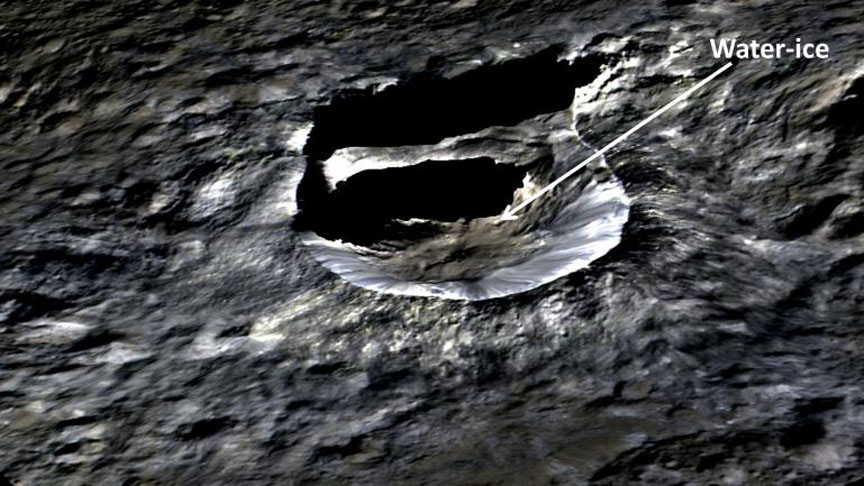
While Ahuna Mons may have erupted liquid water in the not-too-distant past, Dawn found probable water ice right now in the mid-latitude Oxo Crater using its visible and infrared mapping spectrometer (VIR).
The small, bright crater Oxo (6 miles / 10 km wide) on Ceres is seen in this perspective view. The elevation has been exaggerated by a factor of two. The view was made using enhanced-color images from NASA’s Dawn mission. Dawn’s visible and infrared mapping spectrometer (VIR) has found evidence of water ice at this crater. Credit: NASA/JPL-Caltech/UCLA/MPS/DLR/IDA
Exposed water-ice is rare on the dwarf planet, but the low density of Ceres — 2.08 grams/cm3 vs. 5.5 for Earth — the impact-generated ice detection and the the existence of Ahuna Mons suggest that Ceres’ crust does contain a significant amount of water ice.
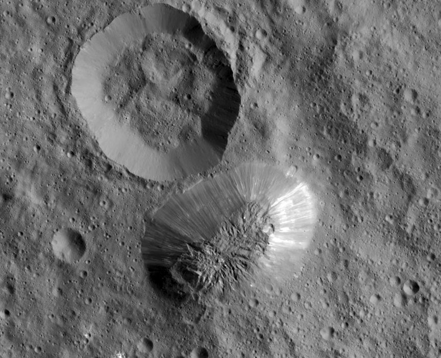
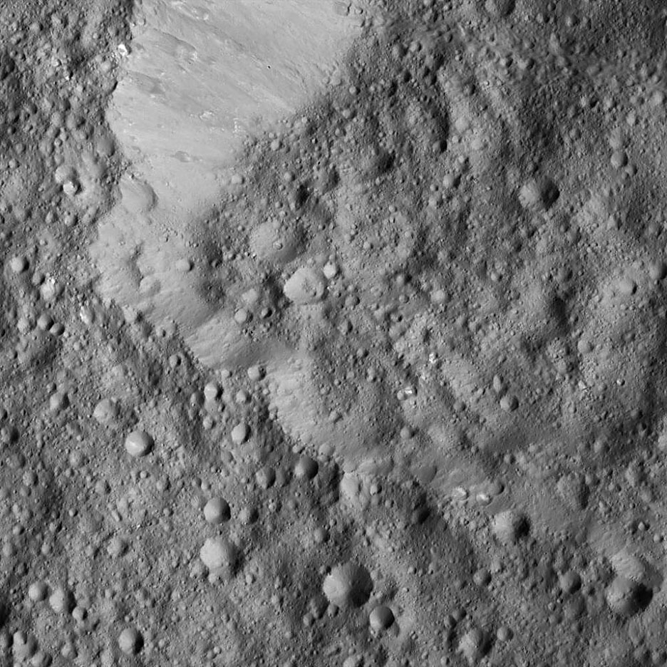
Impact craters are clearly the most abundant geological feature on Ceres, and their different shapes help tell the complex story of Ceres’ past. Craters that are roughly polygonal — shapes bounded by straight lines — hint that Ceres’ crust is heavily fractured. In addition, several Cerean craters display fractures on their floors. There are craters with flow-like features. Bright areas are peppered across Ceres, with the most reflective ones in Occator Crater. Some crater shapes could indicate water-ice in the subsurface.
In this illustration, a mud slurry rises up through Ceres’ crust to build a dome like Ahuna Mons. Click to see the animation. Credit: Goddard Media Studios
All these crater forms imply an outer shell for Ceres that is not purely ice or rock, but rather a mixture of both. Scientists also calculated the ratio of various craters’ depths to diameters, and found that some amount of crater relaxation must have occurred as icy walls gradually slump.
“The uneven distribution of craters indicates that the crust is not uniform, and that Ceres has gone through a complex geological evolution,” Hiesinger said.
The rim of Hamori Crater on Ceres is seen in the upper left portion of this image, which was taken by NASA’s Dawn spacecraft. Clay is found at many locations on the dwarf planet. Credit: NASA/JPL-Caltech/UCLA/MPS/DLR/IDA
Ceres’ crust also appears loaded with clay-forming minerals called phyllosilicates. These phyllosilicates are rich in magnesium and also have some ammonium embedded in their crystalline structure. Their distribution throughout the dwarf planet’s crust indicates Ceres’ surface material has been altered by a global process involving water.
Now in its extended mission, the Dawn spacecraft has been increasing its altitude since Sept. 2 as scientists stand back once again for a broader look at Ceres under different lighting conditions now compared to earlier in the mission.
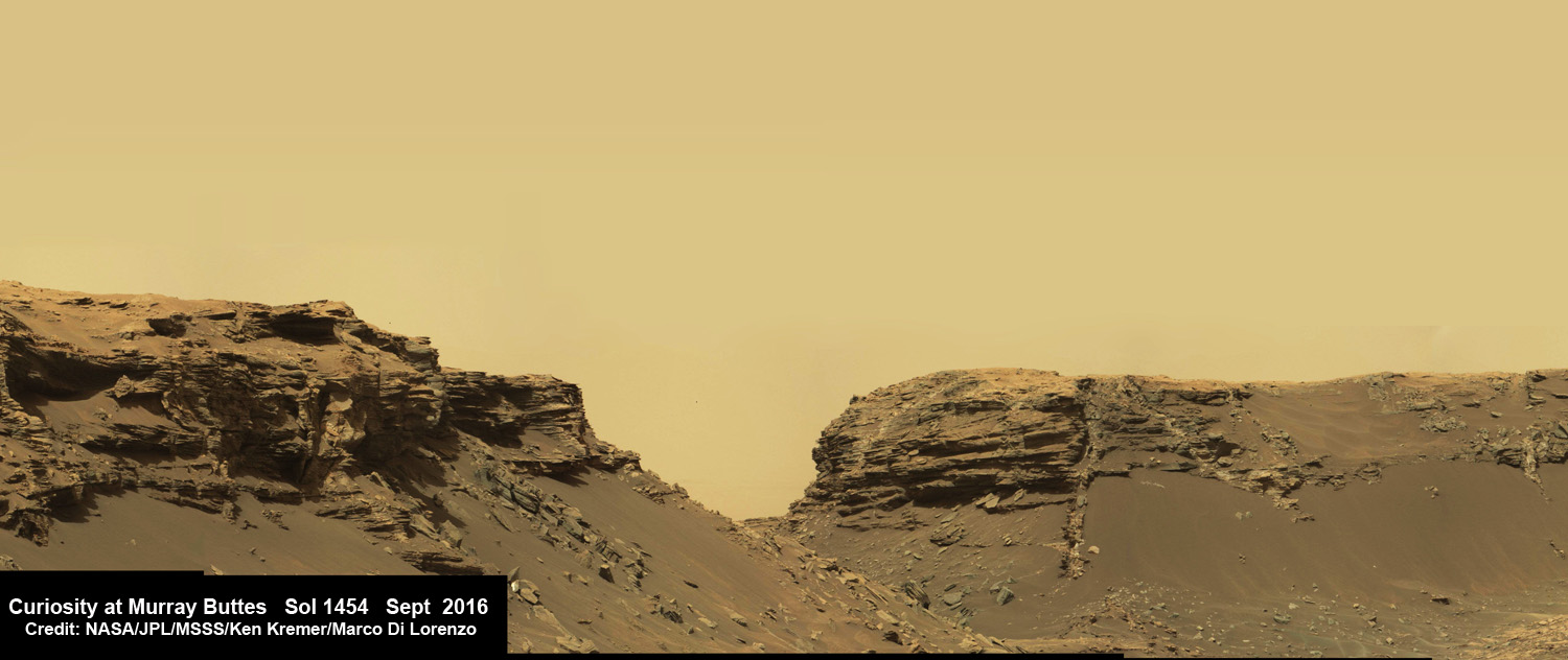
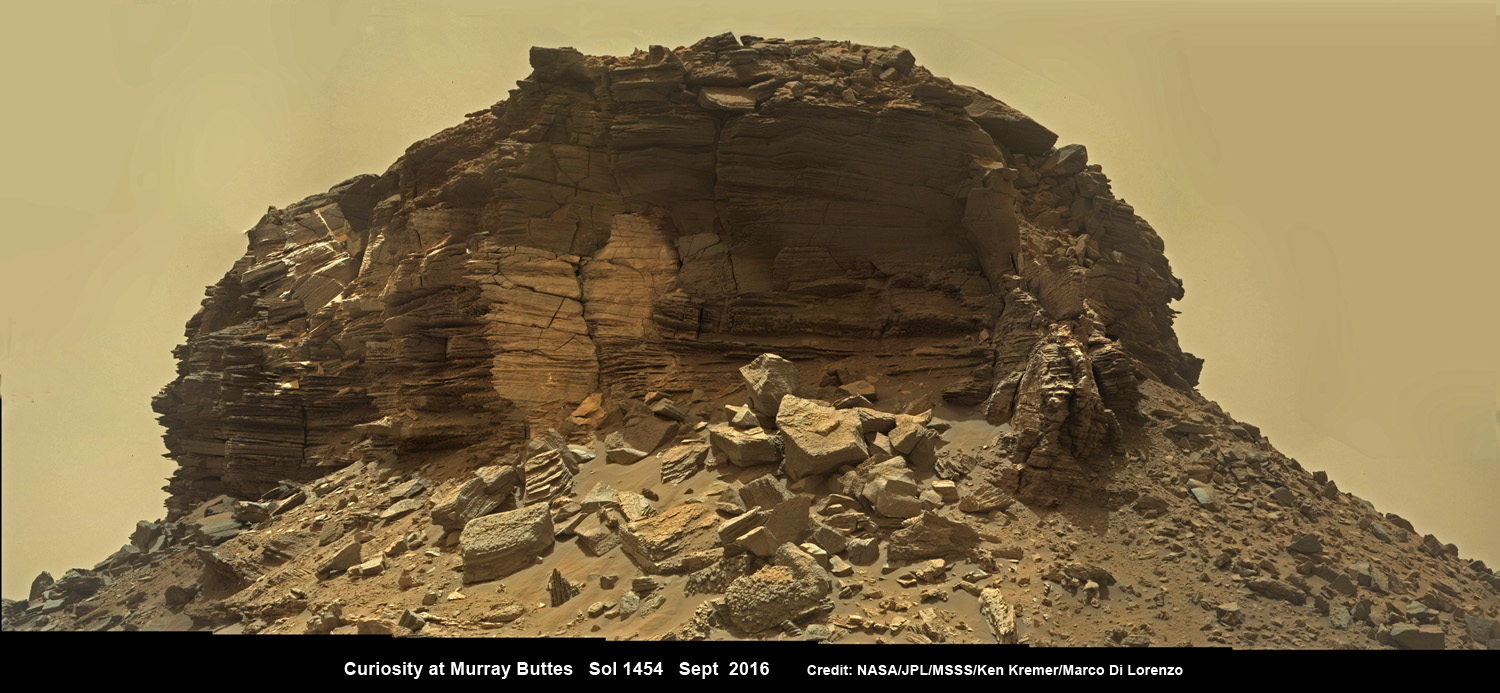
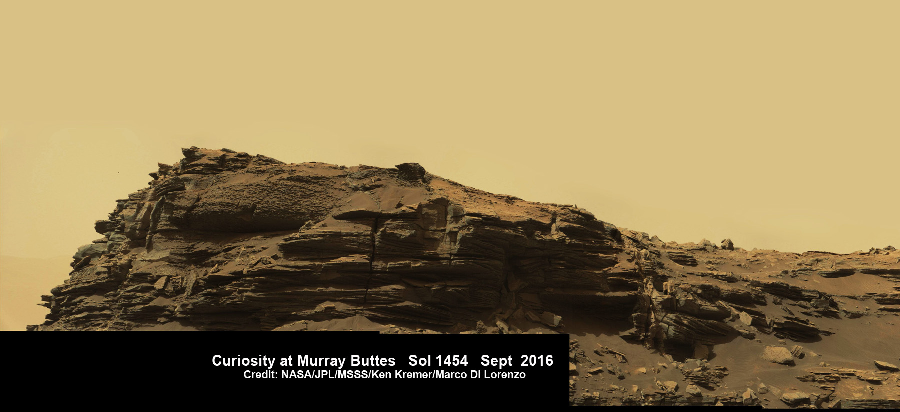
Dramatic hillside view showing sloping buttes and layered outcrops within of the Murray Buttes region on lower Mount Sharp from the Mast Camera (Mastcam) on NASA's Curiosity Mars rover. This photo mosaic is stitched and cropped from Mastcam camera raw images taken on Sol 1454, Sept. 8, 2016, with added artificial sky. Credit: NASA/JPL/MSSS/Ken Kremer/kenkremer.com/Marco Di Lorenzo
Spectacular wide angle mosaic view showing sloping buttes and layered outcrops within the Murray Buttes region on lower Mount Sharp from the Mast Camera (Mastcam) on NASA’s Curiosity Mars rover. This photo mosaic is stitched from Mastcam camera raw images taken on Sol 1454, Sept. 8, 2016 with added artificial sky. Credit: NASA/JPL/MSSS/Ken Kremer/kenkremer.com/Marco Di Lorenzo
The most stunning panoramic vistas likely ever snapped by NASA’s Curiosity rover reveal spectacularly layered Martian rock formations in such exquisite detail that they look and feel just like America’s desert Southwest landscapes. They were just captured a week ago and look like a scene straight out of the hugely popular science fiction movie ‘The Martian’ – only they are real !!
Indeed several magnificent panoramas were taken by Curiosity in just the past week and you can see our newly stitched mosaic versions of several – above and below.
The rock formations lie in the “Murray Buttes” region of lower Mount Sharp where Curiosity has been exploring for roughly the past month. She just finished a campaign of detailed science observations and is set to bore a new sampling hole into the Red Planet, as you read this.
While scouting around the “Murray Buttes,” the SUV sized rover captured thousands of color and black and white raw images to document the geology of this thus far most unrivaled spot on the Red Planet ever visited by an emissary from Earth.
So the image processing team of Ken Kremer and Marco Di Lorenzo has begun stitching together wide angle mosaic views starting with images gathered by the high resolution mast mounted Mastcam right color camera, or M-100, on Sept, 8, 2016, or Sol 1454 of the robots operations on Mars.
Dramatic closeup mosaic view of Martian butte with sandstone layers showing cross-bedding in the Murray Buttes region on lower Mount Sharp from the Mast Camera (Mastcam) on NASA’s Curiosity Mars rover. This photo mosaic is stitched from Mastcam camera raw images taken on Sol 1454, Sept. 8, 2016, with added artificial sky. Credit: NASA/JPL/MSSS/Ken Kremer/kenkremer.com/Marco Di Lorenzo
The mosaics give context and show us exactly what the incredible alien surroundings look like where the six wheeled rover is exploring today.
The imagery of the Murray Buttes and mesas show them to be eroded remnants of ancient sandstone that originated when winds deposited sand after lower Mount Sharp had formed.
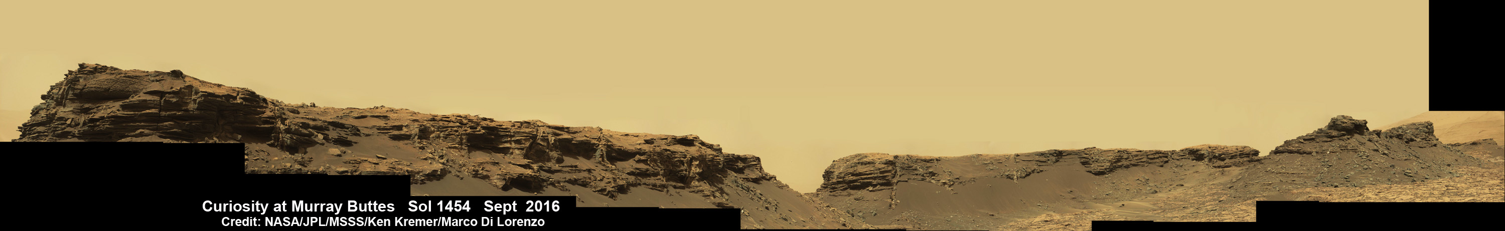
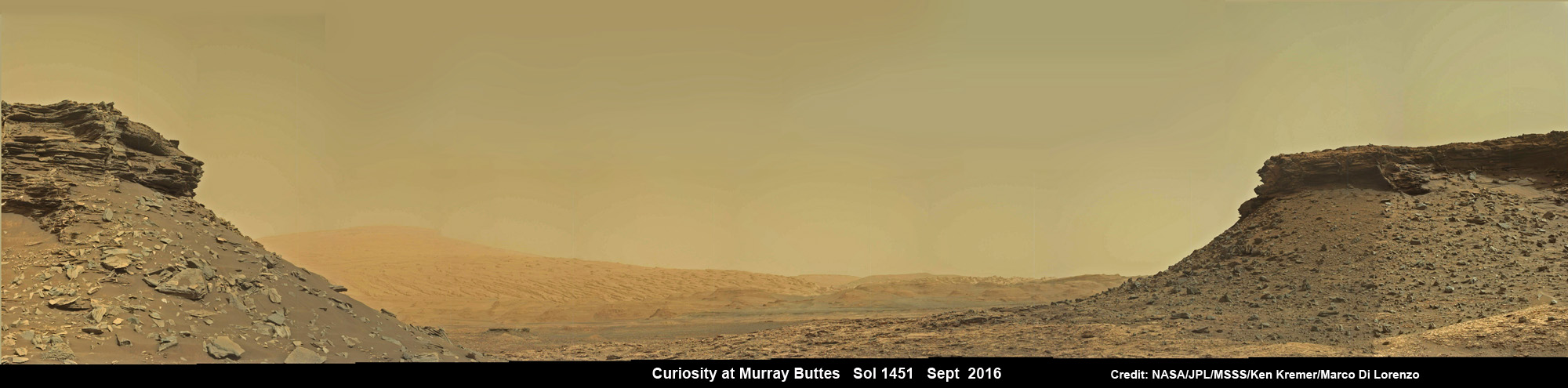
Wide angle mosaic shows lower region of Mount Sharp at center in between spectacular sloping hillsides and layered rock outcrops of the Murray Buttes region in Gale Crater as imaged by the Mast Camera (Mastcam) on NASA’s Curiosity Mars rover. This photo mosaic is stitched from Mastcam camera raw images taken on Sol 1451, Sept. 5, 2016 with added artificial sky. Credit: NASA/JPL/MSSS/Ken Kremer/kenkremer.com/Marco Di Lorenzo
Scanning around the Murray Buttes mosaics one sees finely layered rocks, sloping hillsides, the distant rim of Gale Crater barely visible through the dusty haze, dramatic hillside outcrops with sandstone layers exhibiting cross-bedding. The presence of “cross-bedding” indicates that the sandstone was deposited by wind as migrating sand dunes, says the team.
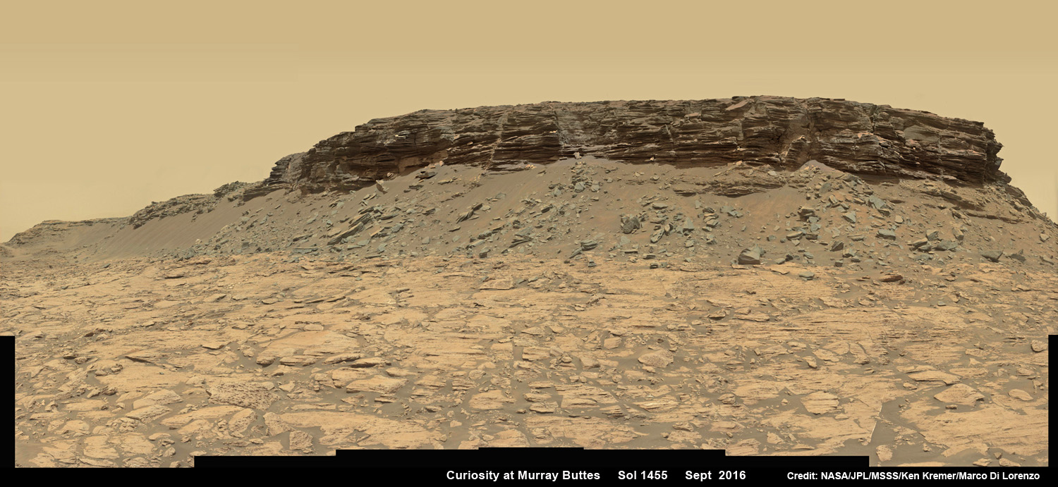
Wide angle mosaic view shows spectacular buttes and layered sandstone in the Murray Buttes region on lower Mount Sharp from the Mastcam cameras on NASA’s Curiosity Mars rover. This photo mosaic was assembled from Mastcam color camera raw images taken on Sol 1455, Sept. 9, 2016 and stitched by Marco Di Lorenzo and Ken Kremer, with added artificial sky. Credit: NASA/JPL/MSSS/Ken Kremer/kenkremer.com/Marco Di Lorenzo
But there is no time to rest as she was commanded to head further south to the last of these Murray Buttes. And right now the team is implementing a plan for Curiosity to drill a new hole in Mars today – at a target named “Quela” at the base of the last of the buttes. The rover approached the butte from the south side a few days ago to get in place and plan for the drilling, take imagery to document stratigraphy and make compositional observations with the ChemCam laser instrument.
“It’s always an exciting day on Mars when you prepare to drill another sample – an engineering feat that we’ve become so accustomed to that I sometimes forget how impressive this really is!” wrote Lauren Edgar, in a mission update today. Edgar is a Research Geologist at the USGS Astrogeology Science Center and a member of the MSL science team.
Curiosity will then continue further south to begin exploring higher and higher sedimentary layers up Mount Sharp. The “Murray Buttes” are the entry way along Curiosity’s planned route up lower Mount Sharp.
Dramatic closeup view of hillside outcrop with sandstone layers showing cross-bedding in the Murray Buttes region on lower Mount Sharp from the Mast Camera (Mastcam) on NASA’s Curiosity Mars rover. This photo mosaic is stitched and cropped from Mastcam camera raw images taken on Sol 1454, Sept. 8, 2016, with added artificial sky. Credit: NASA/JPL/MSSS/Ken Kremer/kenkremer.com/Marco Di Lorenzo
Meanwhile Curiosity is still conducting science observations of the last drill sample gathered from the “Marimba” target in August focusing on MAHLI and APXS examination of the dump pile leftovers from the sieved sample. She just completed chemical analysis of the sieved sample using the miniaturized SAM and CheMin internal chemistry laboratories.
It’s interesting to note that although the buttes are striking, their height also presents communications issues by blocking radio signals with NASA’s orbiting relay satellites. NASA’s Opportunity rover faced the same issues earlier this year while exploring inside the high walled Marathon Valley along Ecdeavour Crater.
“While the buttes are beautiful, they pose a challenge to communications, because they are partially occluding communications between the rover and the satellites we use to relay data (MRO and ODY), so sometimes the data volume that we can relay is pretty low” wrote Edgar.
“But it’s a small price to pay for the great stratigraphic exposures and gorgeous view!”
Dramatic hillside view showing sloping buttes and layered outcrops within of the Murray Buttes region on lower Mount Sharp from the Mast Camera (Mastcam) on NASA’s Curiosity Mars rover. This photo mosaic is stitched and cropped from Mastcam camera raw images taken on Sol 1454, Sept. 8, 2016, with added artificial sky. Credit: NASA/JPL/MSSS/Ken Kremer/kenkremer.com/Marco Di Lorenzo
Ascending and diligently exploring the sedimentary lower layers of Mount Sharp, which towers 3.4 miles (5.5 kilometers) into the Martian sky, is the primary destination and goal of the rovers long term scientific expedition on the Red Planet.
Three years ago, the team informally named the Murray Buttes site to honor Caltech planetary scientist Bruce Murray (1931-2013), a former director of NASA’s Jet Propulsion Laboratory, Pasadena, California. JPL manages the Curiosity mission for NASA.
As of today, Sol 1461, September 15, 2016, Curiosity has driven over 7.9 miles (12.7 kilometers) since its August 2012 landing inside Gale Crater, and taken over 353,000 amazing images.
Stay tuned here for Ken’s continuing Earth and planetary science and human spaceflight news.
Curiosity rover panorama of Mount Sharp captured on June 6, 2014 (Sol 651) during traverse inside Gale Crater. Note rover wheel tracks at left. She will eventually ascend the mountain at the ‘Murray Buttes’ at right later this year. Assembled from Mastcam color camera raw images and stitched by Marco Di Lorenzo and Ken Kremer. Credit: NASA/JPL/MSSS/Marco Di Lorenzo/Ken Kremer-kenkremer.com
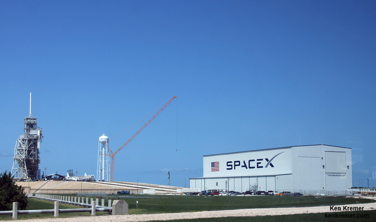
SpaceX is renovating Launch Complex 39A at the Kennedy Space Center for launches of the Falcon Heavy and human rated Falcon 9. Credit: Ken Kremer/kenkremer.com
SpaceX is renovating Launch Complex 39A at the Kennedy Space Center for launches of the Falcon Heavy and human rated Falcon 9. Credit: Ken Kremer/kenkremer.com
“We’re anticipating getting back to flight, being down for about three months, so getting back to flight in November, the November timeframe,” Shotwell announced on Sept. 13, during a panel discussion at the World Satellite Business Week Conference being held in Paris, France.
The catastrophic Sept. 1 launch pad explosion took place without warning at SpaceX’s Space Launch Complex-40 launch facility at approximately 9:07 a.m. EDT on Cape Canaveral Air Force Station, Fl during a routine fueling test.
Both the $60 million SpaceX rocket and the $200 million AMOS-6 Israeli commercial communications satellite payload were completely destroyed in a massive fireball that erupted suddenly during a routine and planned pre-launch fueling and engine ignition test at pad 40 on Sept. 1.
However, SpaceX is still seeking to determine the root cause of the catastrophe, which must be fully determined, corrected and rectified before any new Falcon 9 launches can actually occur.
Indeed nailing down the root cause has thus far confounded SpaceX investigators and was labeled as the “most difficult and complex failure” in its history said SpaceX CEO and Founder Elon Musk in a series of update tweets on Sept. 9. He also sought the public’s help in ascertaining the elusive cause via any audio/video recordings.
The rocket failure originated somewhere in the upper stage near the liquid oxygen (LOX) tank during fueling test operations at the launch pad, for what is known as a hot fire engine ignition test of all nine first stage Merlin 1D engines, said Musk.
Engineers were in the final stages of loading the liquid oxygen (LOX) and RP-1 kerosene propellants that power the Falcon 9 first stage for the static fire test which is a full launch dress rehearsal. The anomaly took place about 8 minutes before the planned engine hot fire ignition.
Shotwell also stated that the launch would occur from SpaceX’s other Florida Space Coast launch pad – namely the former Space Shuttle Launch Complex 39A on the Kennedy Space Center.
SpaceX also operates a third launch pad at Vandenberg Air Force Base in California.
“We would launch from the East Coast on Pad 39A in the November timeframe. And then Vandenberg would be available … for our other assorted customers,” Shotwell stated.
SpaceX has signed a long term lease with NASA to use Pad 39A.
Shotwell did not say which payload would be the first to launch.
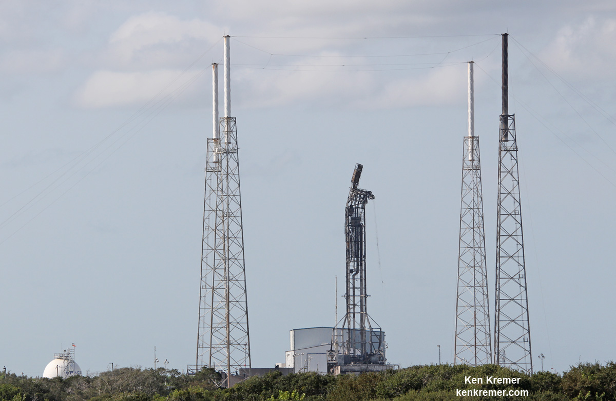
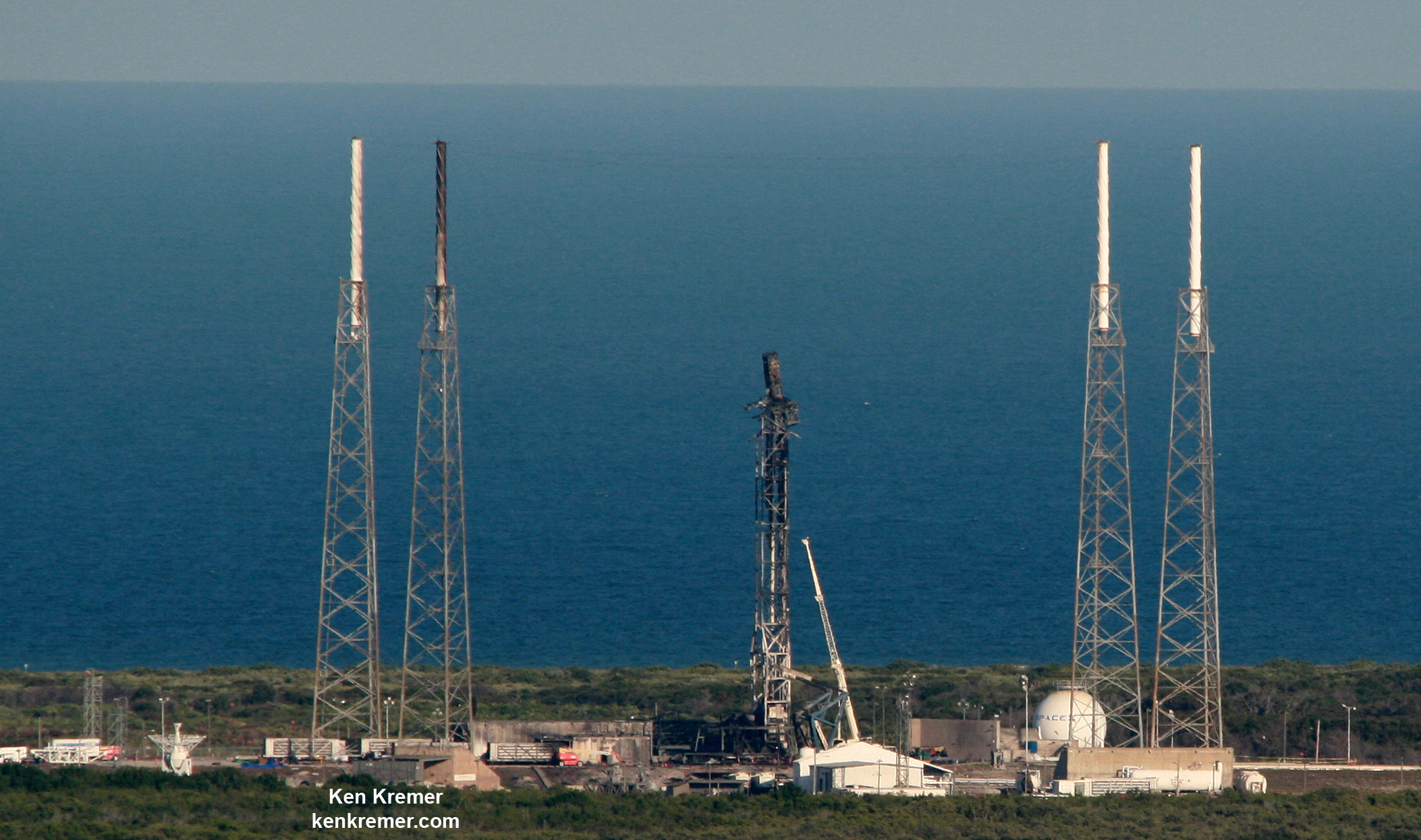
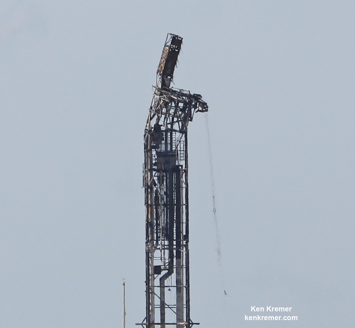
Mangled SpaceX Falcon 9 strongback with dangling cables (at right) as seen on Sept. 7 after prelaunch explosion destroyed the rocket and AMOS-6 payload at Space Launch Complex-40 at Cape Canaveral Air Force Station, FL on Sept. 1, 2016 . Credit: Ken Kremer/kenkremer.com
The incident took place less than two days before the scheduled Falcon 9 launch of AMOS-6 on Sept. 3 from pad 40.
The Sept. 1 calamity disaster also counts as the second time a Falcon 9 has exploded in 15 months and will call into question the rocket’s reliability. The first failure involved a catastrophic mid air explosion about two and a half minutes after liftoff, during the Dragon CRS-9 cargo resupply launch for NASA to the International Space Station on June 28, 2015 – and witnessed by this author.
While launching from pad 40, SpaceX has simultaneously been renovating and refurbishing NASA’s former shuttle launch at Complex 39A – from which the firm hopes to launch the new Falcon Heavy booster as well as human rated launches of the Falcon 9 with the Crew Dragon to the ISS.
SpaceX will have to finish the pad 39A upgrades soon in order to have any hopes of achieving a November return to flight launch date, and a lot of work remains to be done. For example the shuttle era Rotating Service Structure (RSS) is still standing. The timing for its demolishment has not been announced, according to a source.
Prior to launching from 39A, SpaceX would presumably roll out a Falcon 9 rocket to conduct fit checks and conduct a full launch dress rehearsal and first stage static hot fire engine test to confirm that all the newly installed equipment, gear and fueling lines, pumps, etc. are fully functional, operational and safe.
Aerial view of pad and strongback damage at SpaceX Launch Complex-40 as seen from the VAB roof on Sept. 8, 2016 after fueling test explosion destroyed the Falcon 9 rocket and AMOS-6 payload at Cape Canaveral Air Force Station, FL on Sept. 1, 2016. Credit: Ken Kremer/kenkremer.com
The rocket disaster was coincidentally captured as it unfolded in stunning detail in a spectacular up close video recorded by my space journalist colleague at USLaunchReport – shown below.
Here is the full video from my space journalist friend and colleague Mike Wagner of USLaunchReport:
Video Caption: SpaceX – Static Fire Anomaly – AMOS-6 – 09-01-2016. Credit: USLaunchReport
The 229-foot-tall (70-meter) SpaceX Falcon 9 had been slated for an overnight blastoff on Saturday, September 3 at 3 a.m. from pad 40 with the 6 ton AMOS-6 telecommunications satellite valued at some $200 million.
The AMOS-6 communications satellite was built by Israel Aerospace Industries for Space Communication Ltd. It was planned to provide communication services including direct satellite home internet for Africa, the Middle East and Europe.
The Falcon 9 rocket and AMOS-6 satellite were swiftly consumed in a huge fireball and thunderous blasts accompanied by a vast plume of smoke rising from the wreckage that was visible for many miles around the Florida Space Coast.
“Loss of Falcon vehicle today during propellant fill operation,” Musk tweeted several hours after the launch pad explosion.
“Originated around upper stage oxygen tank. Cause still unknown. More soon.”
The explosion also caused extensive damage to the rockets transporter erector, or strongback, that holds the rocket in place until minutes before liftoff, and ground support equipment (GSE) around the pad – as seen in my new photos of the pad taken a week after the explosion.
Dangling cables and gear such as pulley’s and more can clearly be seen to still be present as the strongback remains raised at pad 40. The strongback raises the rocket at the pad and also houses multiple umbilical line for electrical power, purge gases, computer communications and more.
One of the four lightning masts is also visibly burnt and blackened – much like what occurred after the catastrophic Orbital ATK Antares rocket exploded moments after liftoff from a NASA Wallops launch pad on Oct 28, 2014 and witnessed by this author.
Black soot also appears to cover some area of the pads ground support equipment in the new photos.
So it’s very likely that repairs to and re-certification of pad 40 will take at least several months.
Up close view of top of mangled SpaceX Falcon 9 strongback with dangling cables (at right) as seen on Sept. 7 after prelaunch explosion destroyed the rocket and AMOS-6 payload at Space Launch Complex-40 at Cape Canaveral Air Force Station, FL on Sept. 1, 2016 . Credit: Ken Kremer/kenkremer.com
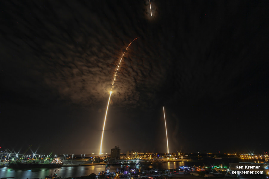
Launch of SpaceX Falcon 9 carrying JCSAT-16 Japanese communications satellite to orbit on Aug. 14, 2016 at 1:26 a.m. EDT from Space Launch Complex 40 at Cape Canaveral Air Force Station, Fl. Credit: Ken Kremer/kenkremer.com
And Shotwell pointed to the numerous successful SpaceX launches in her conference remarks.
“So now let’s look to the good. We did have an extraordinary launch year. We launched 9 times in just under 8 months, in the past year successfully,” Shotwell elaborated.
Shotwell was referring to the upgraded, full thrust version of the Falcon 9 first launched in Dec. 2015
“We rolled out a new vehicle, which we flew last December. And that vehicle was the vehicle that was designed to land.”
“And so we did recover the first stage six times. Twice back on land. And four times on the droneship. Which I think is an extraordinary move for the industry.”
“I don’t know that everyone appreciates it, but certainly that is a leap forward in launches for our customers.”
SpaceX Falcon 9 launches and lands over Port Canaveral in this streak shot showing rockets midnight liftoff from Space Launch Complex 40 at Cape Canaveral Air Force Station in Florida at 12:45 a.m. EDT on July 18, 2016 carrying Dragon CRS-9 craft to the International Space Station (ISS) with almost 5,000 pounds of cargo and docking port. View from atop Exploration Tower in Port Canaveral. Credit: Ken Kremer/kenkremer.com
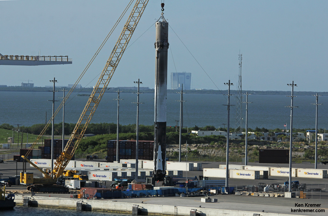
This recovered 156-foot-tall (47-meter) SpaceX Falcon 9 first stage has arrived back into Port Canaveral, FL after successfully launching JCSAT-16 Japanese communications satellite to orbit on Aug. 14, 2016 from Space Launch Complex 40 at Cape Canaveral Air Force Station, Fl. NASA’s VAB in the background – as seen from Exploration Tower on Aug. 19. Credit: Ken Kremer/kenkremer.com
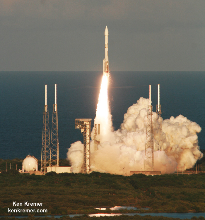
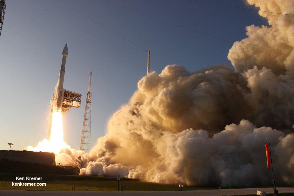
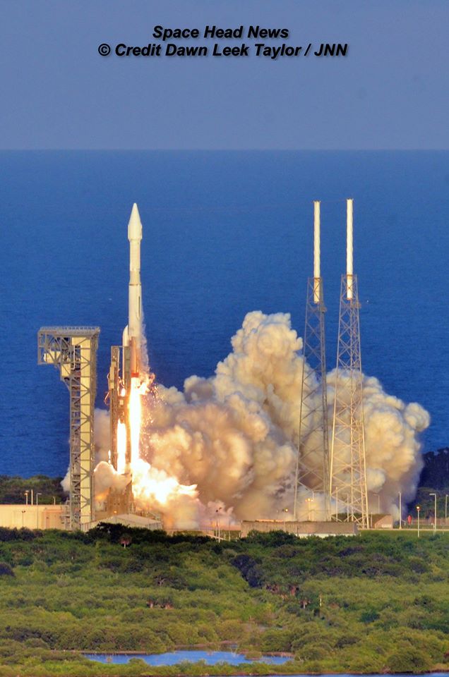
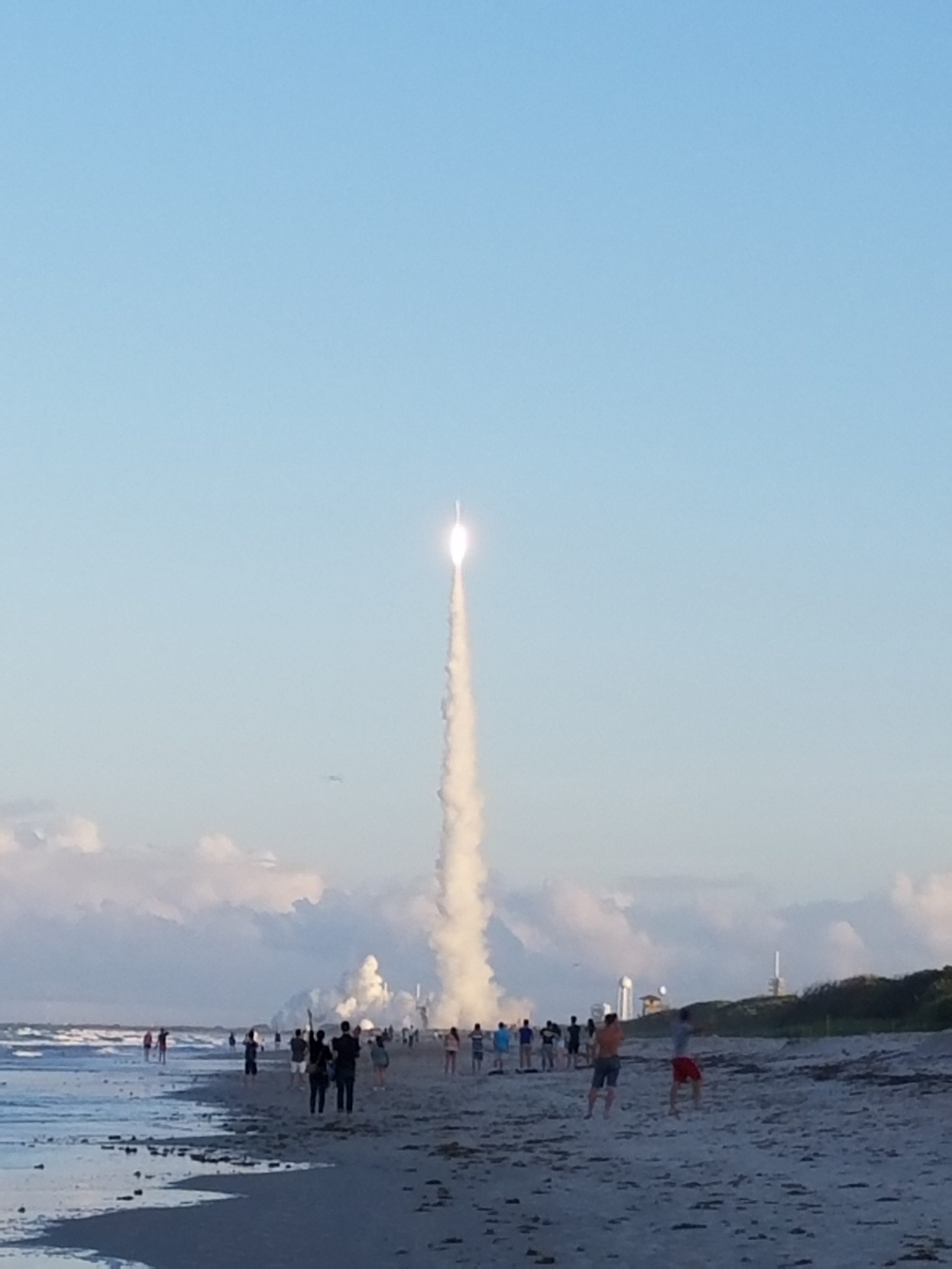
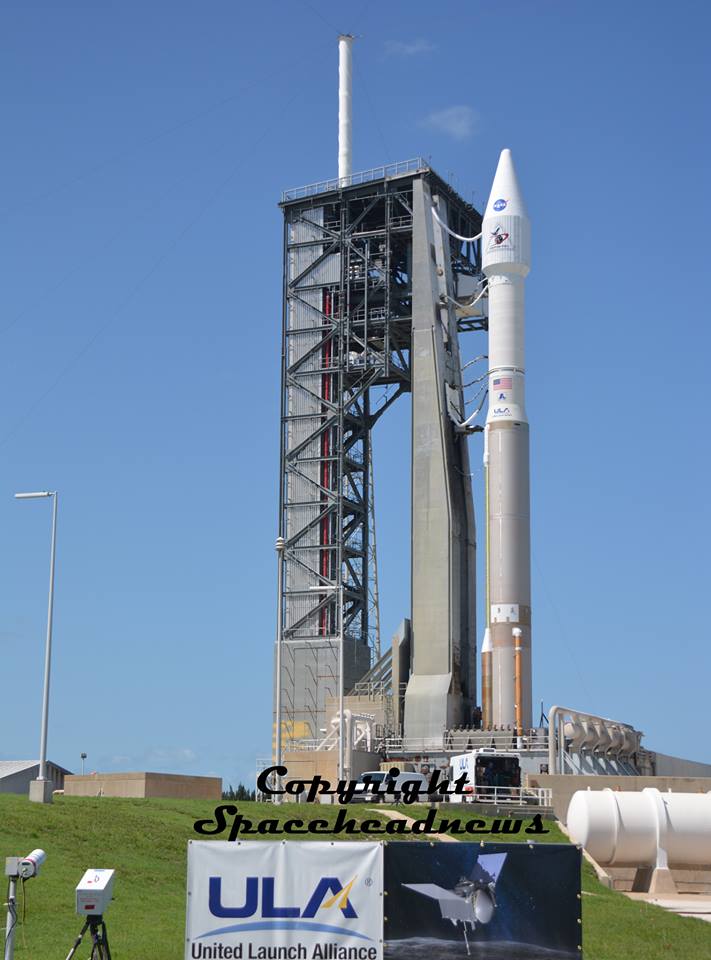
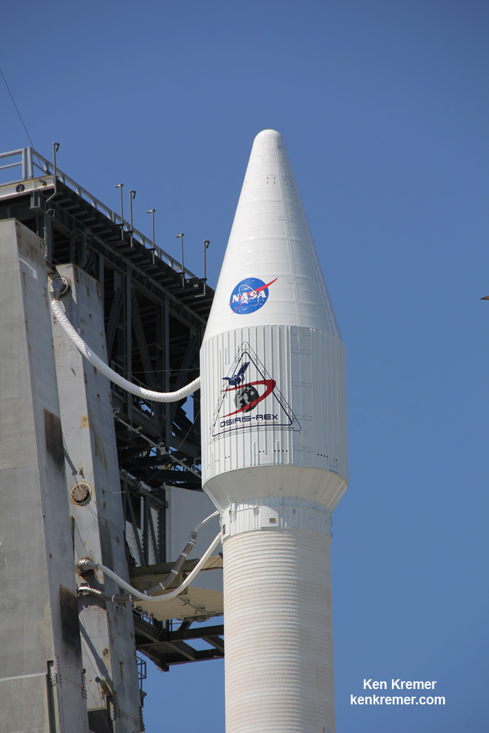
A United Launch Alliance Atlas V rocket lifts off from Space Launch Complex 41 at Cape Canaveral Air Force Station carrying NASA’s Origins, Spectral Interpretation, Resource Identification, Security-Regolith Explorer, or OSIRIS-REx spacecraft on the first U.S. mission to sample an asteroid, retrieve at least two ounces of surface material and return it to Earth for study. Liftoff was at 7:05 p.m. EDT on September 8, 2016. Credit: Ken Kremer/kenkremer.com
A United Launch Alliance Atlas V rocket lifts off from Space Launch Complex 41 at Cape Canaveral Air Force Station carrying NASA’s Origins, Spectral Interpretation, Resource Identification, Security-Regolith Explorer, or OSIRIS-REx spacecraft on the first U.S. mission to sample an asteroid, retrieve at least two ounces of surface material and return it to Earth for study. Liftoff was at 7:05 p.m. EDT on September 8, 2016. Credit: Ken Kremer/kenkremer.com
The Earth departure for NASA’s Origins, Spectral Interpretation, Resource Identification, Security – Regolith Explorer (OSIRIS-REx) spacecraft began with an on time engine ignition from Space Launch Complex 41 at Cape Canaveral Air Force Station on a United Launch Alliance Atlas V rocket shortly before a crystal clear sunset this evening, Thursday, September 8 at 7:05 p.m. EDT.
The Atlas V rocket with OSIRIS-Rex bolted on top roared off launch pad 41 and shot straight up into the sun drenched skies of the sunshine state.
The launch wowed hordes of excited spectators who gathered from near and far to witness America’s first mission to gather pristine samples of soil and rock from Bennu’s coal black and carbon rich surface – and eventually return them to Earth for analysis using the most powerful science instruments humankind has invented.
A United Launch Alliance Atlas V rocket lifts off from Space Launch Complex 41 at Cape Canaveral Air Force Station carrying NASA’s Origins, Spectral Interpretation, Resource Identification, Security-Regolith Explorer, or OSIRIS-REx spacecraft on the first U.S. mission to sample an asteroid, retrieve at least two ounces of surface material and return it to Earth for study. Liftoff was at 7:05 p.m. EDT on September 8, 2016. Credit: Ken Kremer/kenkremer.com
“This represents the hopes and dreams and blood, sweat and tears of thousands of people who have been working on this for years,” said Dante Lauretta, the principal investigator for OSIRIS-REx at the University of Arizona.
“I can’t tell you how thrilled I was this evening, thinking of the people who played a part in this.”
OSIRIS-Rex is on a totally unique 4.5 billion mile roundtrip mission to unlock the mysteries of the formation of our Solar System 4.5 Billion years ago and ourselves as Earth evolved over time.
“Today, we celebrate a huge milestone for this remarkable mission, and for this mission team,” said NASA Administrator Charles Bolden, in a statement.
“We’re very excited about what this mission can tell us about the origin of our solar system, and we celebrate the bigger picture of science that is helping us make discoveries and accomplish milestones that might have been science fiction yesterday, but are science facts today.” Liftoff of NASA’s Origins, Spectral Interpretation, Resource Identification, Security-Regolith Explorer, or OSIRIS-Rex asteroid sampling spacecraft on September 8, 2016 from Cape Canaveral Air Force Station, FL. Credit: Ken Kremer/kenkremer.com
101955 Bennu is a near Earth asteroid discovered in 1999. It was selected specifically as the sampling because it is a carbon-rich asteroid.
It will take about 2 years for OSIRIS-Rex to reach Bennu in 2018 following a flyby of Earth in 2017.
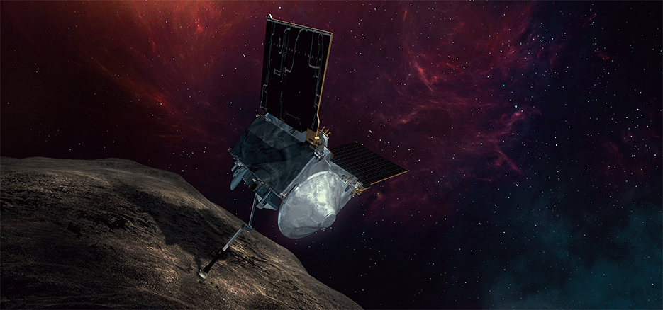
While orbiting Bennu starting in 2018 it will move in close explore Bennu for about two years with its suite of science instruments. After a thorough site selection, it will move carefully towards the surface and extend the 11 foot long TAGSAM robotic arm and snatch pristine soil samples containing organic materials from the surface using the TAGSAM collection dish. The dish will then be placed inside the Earth return canister and be brought back to Earth for study by researchers using all of the most sophisticated science instruments available to humankind.
The asteroid is 1,614-foot (500 m) in diameter and crosses Earth’s orbit around the sun every six years.
Using the 11 foot long TAGSAM robotic arm that functions somewhat like a pogo stick, OSIRIS-REx will gather rocks and soil and bring at least a 60-gram (2.1-ounce) sample back to Earth in 2023. It has the capacity to scoop up to about 2 kg or more.
Liftoff of NASA’s Origins, Spectral Interpretation, Resource Identification, Security-Regolith Explorer, or OSIRIS-Rex asteroid sampling spacecraft on September 8, 2016 from Cape Canaveral Air Force Station, FL. Credit: Julian Leek
The two stage ULA Atlas V performed flawlessly and delivered OSIRIS-Rex into a hyperbolic trajectory away from Earth.
The 189 foot tall ULA Atlas V rocket launched in the rare 411 configuration for only the 3rd time on this mission – which is the 65th for the Atlas V.
The Atlas 411 vehicle includes a 4-meter diameter large Payload Fairing (PLF) and one solid rocket booster that augments the first stage. The Atlas booster for this mission is powered by the RD AMROSS RD-180 engine and the Centaur upper stage was powered by the Aerojet Rocketdyne RL10A.
The RD-180 burns RP-1 (Rocket Propellant-1 or highly purified kerosene) and liquid oxygen and delivers 860,200 lb of thrust at sea level.
The strap on solid delivers approximately 348,500 pounds of thrust.
The Centaur delivers 22,230 lbf of thrust and burns liquid oxygen and liquid hydrogen.
The solid was jettisoned at 139 seconds after liftoff.
This is ULA’s eighth launch in 2016 and the 111th successful launch since the company was formed in December 2006.
Liftoff of NASA’s Origins, Spectral Interpretation, Resource Identification, Security-Regolith Explorer, or OSIRIS-Rex asteroid sampling spacecraft on September 8, 2016 from Cape Canaveral Air Force Station, FL. Credit: Dawn Leek Taylor
OSIRIS-REx will return the largest sample from space since the American and Soviet Union’s moon landing missions of the 1970s.
OSIRIS-REx is the third mission in NASA’s New Frontiers Program, following New Horizons to Pluto and Juno to Jupiter, which also launched on Atlas V rockets.
NASA’s Goddard Space Flight Center in Greenbelt, Maryland, is responsible for overall mission management.
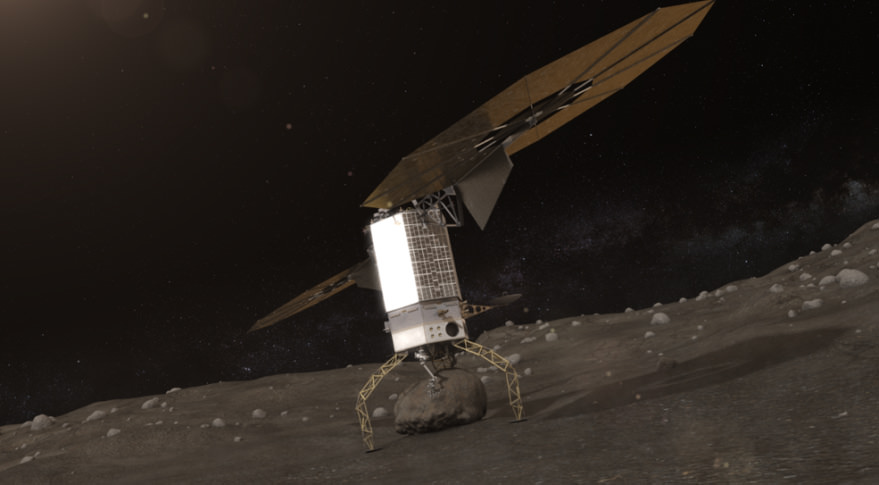
OSIRIS-REx complements NASA’s Asteroid Initiative – including the Asteroid Redirect Mission (ARM) which is a robotic spacecraft mission aimed at capturing a surface boulder from a different near-Earth asteroid and moving it into a stable lunar orbit for eventual up close sample collection by astronauts launched in NASA’s new Orion spacecraft. Orion will launch atop NASA’s new SLS heavy lift booster concurrently under development.
Blastoff of NASA’s OSIRIS-Rex asteroid sampling spacecraft on September 8, 2016 from Cape Canaveral Air Force Station, FL as seen from Playalinda Beach. Credit: Jillian Laudick
Watch for Ken’s continuing OSIRIS-REx mission and launch reporting from on site at the Kennedy Space Center and Cape Canaveral Air Force Station, FL.
Stay tuned here for Ken’s continuing Earth and planetary science and human spaceflight news.
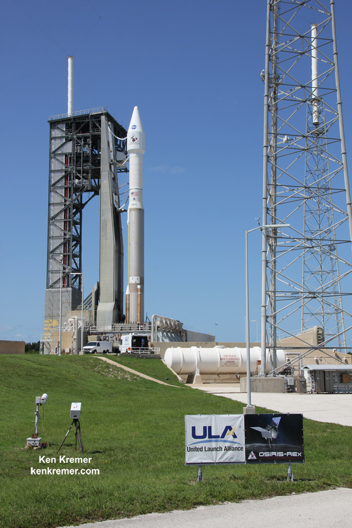
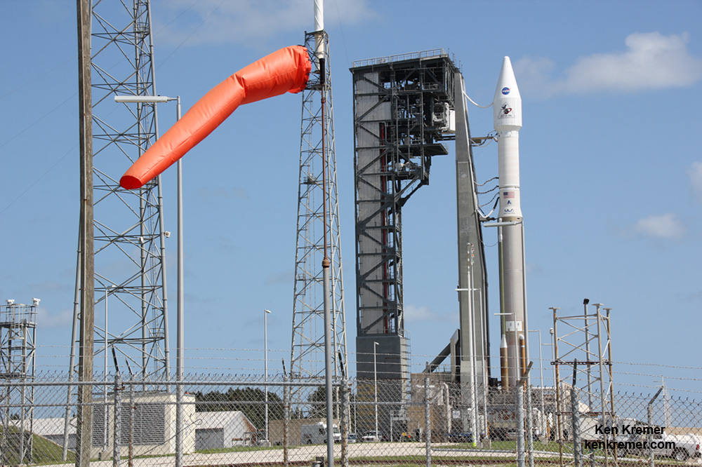
NASA’s OSIRIS-REx asteroid sampling spacecraft atop a ULA Atlas V rocket prior to launch on Sept. 8, 2016 from Space Launch Complex 41 on Cape Canaveral Air Force Station, FL. Credit: Lane Hermann/SpaceHeadNewsNASA’s OSIRIS-REx asteroid sampling spacecraft is poised for liftoff on a 7 year Journey to asteroid Bennu and Back atop a United Launch Alliance Atlas V rocket on Sept. 8, 2016 from Space Launch Complex 41 on Cape Canaveral Air Force Station, FL. Credit: Ken Kremer/kenkremer.comArtist’s conception of NASA’s OSIRIS-REx sample return spacecraft collecting regolith samples at asteroid Bennu. Credits: NASA/Lockheed Martin
NASA’s OSIRIS-REx asteroid sampling spacecraft is poised for liftoff on a 7 year Journey to asteroid Bennu and Back atop a United Launch Alliance Atlas V rocket on Sept. 8, 2016 from Space Launch Complex 41 on Cape Canaveral Air Force Station, FL. Credit: Ken Kremer/kenkremer.com
NASA’s OSIRIS-REx asteroid sampling spacecraft is poised for liftoff on a 7 year Journey to asteroid Bennu and Back atop a United Launch Alliance Atlas V rocket on Sept. 8, 2016 from Space Launch Complex 41 on Cape Canaveral Air Force Station, FL. Credit: Ken Kremer/kenkremer.com
KENNEDY SPACE CENTER, FL – Today is ‘Earth Departure Day’ for OSIRIS-REx, NASA’s first mission to snatch “pristine materials” from the surface of a near Earth asteroid named Bennu and deliver them back to Earth in seven years on a mission to unlock mysteries on the formation of our Solar System and ourselves 4.5 Billion years ago.
The 4.5 Billion mile roundtrip ‘Journey to Bennu and Back’ begins today. All systems are GO for a spectacular dinner-time blastoff of NASAs OSIRIS-REx spacecraft from the Florida Space Coast.
Earth departure for NASA’s Origins, Spectral Interpretation, Resource Identification, Security – Regolith Explorer (OSIRIS-REx) spacecraft from Space Launch Complex 41 at Cape Canaveral Air Force Station on a United Launch Alliance Atlas V rocket is slated for shortly before sunset this evening, Thursday, September 8 at 7:05 p.m. EDT.
Excited spectators are filling local area hotels for this once in a lifetime mission to ‘Bennu and Back.’
Bennu is a small, carbon-rich asteroid – meaning it contains significant amounts of organic molecules, the stuff of which life is made.
Bennu is only about a third of mile in diameter, measuring 500 meters or 1,614 feet across and it crosses Earth’s orbit around the sun every six years.
You can watch the sure to be a spectacular launch live in person here in sunny Florida or live via a choice of webcasts.
NASA’s OSIRIS-REx launch coverage will be broadcast on NASA TV beginning at 4:30 p.m. EDT Sept. 8, as well as on a ULA webcast.
You can watch the launch live at NASA TV at – http://www.nasa.gov/nasatv
You can watch the launch live at ULA at – www.ulalaunch.com
Today’s weather forecast remains very promising and is currently 80% GO for favorable conditions. The only concern is for cumulus clouds.
There are 3 opportunities in a row to launch OSIRIS-Rex.
In case of a delay 24 or 48 hour delay, the forecast drops only slightly to 70% GO.
Artist’s conception of NASA’s OSIRIS-REx sample return spacecraft collecting regolith samples at asteroid Bennu. Credits: NASA/Lockheed Martin
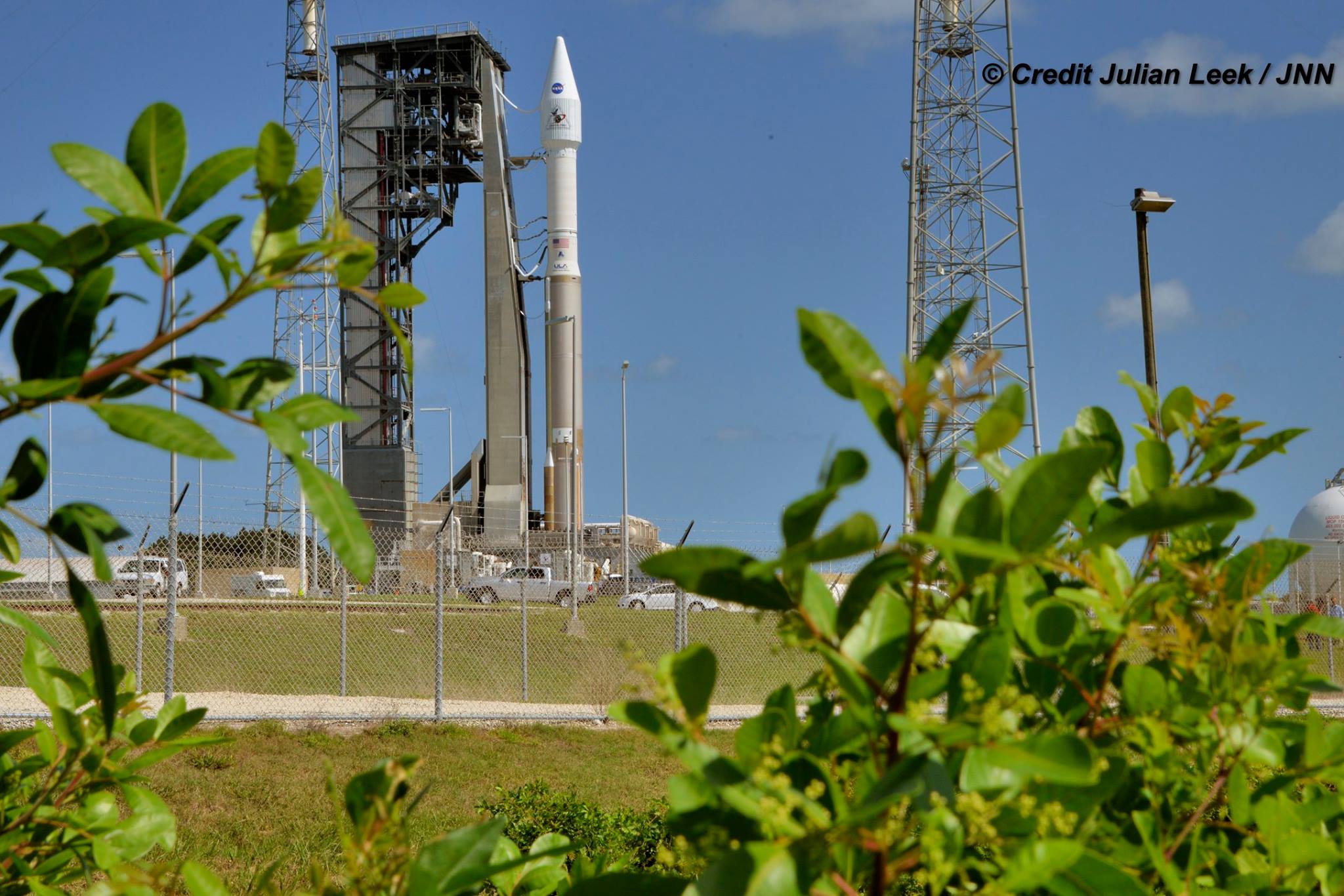
The United Launch Alliance Atlas V rocket and OSIRIS-REx spacecraft were rolled out some 1800 feet from the Vertical Integration Facility (VIF) – where the rocket is assembled- to launch pad 41 starting at about 9 a.m. yesterday morning September 7, 2018.
Watch this OSIRIS-Rex trailer from NASA Goddard illustrating the probes Earth departure launch phase:
NASAs OSIRIS-REx spacecraft is on a mission to explore asteroid Bennu and return a sample to Earth. The OSIRIS-REx launch window opens on September 8, 2016, when the spacecraft begins its two-year journey to Bennu aboard an Atlas V rocket at Cape Canaveral, Florida. After arriving at Bennu in 2018, OSIRIS-REx will spend over a year exploring the asteroid before approaching its surface to grab a sample. This pristine material, formed at the dawn of the solar system, will be returned to Earth in 2023, providing clues to Bennus origins and our own. Credit: NASA’s Goddard Space Flight Center/David Ladd
OSIRIS-REx will gather rocks and soil and bring at least a 60-gram (2.1-ounce) sample back to Earth in 2023. It has the capacity to scoop up to about 2 kg or more.
The mission will help scientists investigate how planets formed and how life began. It will also improve our understanding of asteroids that could impact Earth by measuring the Yarkovsky effect.
Bennu is an unchanged remnant from the collapse of the solar nebula and birth of our solar system some 4.5 billion years ago.
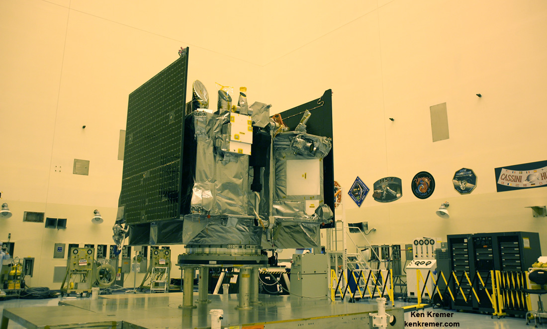
View of science instrument suite and TAGSAM robotic sample return arm on NASA’s OSIRIS-REx asteroid sampling spacecraft inside the Payloads Hazardous Servicing Facility at NASA’s Kennedy Space Center. Probe is slated for Sep. 8, 2016 launch to asteroid Bennu from Cape Canaveral Air Force Station, FL. Credit: Ken Kremer/kenkremer.com
It was chosen as the target because it is little altered over time and thus ‘pristine’ in nature.
Bennu is a near-Earth asteroid and was selected for the sample return mission because it could hold clues to the origin of the solar system and host organic molecules that may have seeded life on Earth.
NASA’s OSIRIS-REx asteroid sampling spacecraft is housed inside the payload fairing atop the United Launch Alliance Atlas V rocket on Sept. 8, 2016 from Space Launch Complex 41 on Cape Canaveral Air Force Station, FL. Credit: Ken Kremer/kenkremer.com
The 189 foot tall ULA Atlas V rocket is launching in the rare 411 configuration for only the 3rd time on this mission – which is the 65th for the Atlas V.
The Atlas 411 vehicle includes a 4-meter diameter payload fairing and one solid rocket booster that augments the first stage. The Atlas booster for this mission is powered by the RD AMROSS RD-180 engine and the Centaur upper stage was powered by the Aerojet Rocketdyne RL10C-1 engine.
The RD-180 burns RP-1 (Rocket Propellant-1 or highly purified kerosene) and liquid oxygen and delivers 860,200 lb of thrust at sea level.
The strap on solids deliver approximately 500,000 pounds of thrust.
The solids will be jettisoned about 2 minutes after liftoff.
OSIRIS-REx will return the largest sample from space since the American and Soviet Union’s moon landing missions of the 1970s.
OSIRIS-REx is the third mission in NASA’s New Frontiers Program, following New Horizons to Pluto and Juno to Jupiter, which also launched on Atlas V rockets.
NASA’s Goddard Space Flight Center in Greenbelt, Maryland, is responsible for overall mission management.
OSIRIS-REx complements NASA’s Asteroid Initiative – including the Asteroid Redirect Mission (ARM) which is a robotic spacecraft mission aimed at capturing a surface boulder from a different near-Earth asteroid and moving it into a stable lunar orbit for eventual up close sample collection by astronauts launched in NASA’s new Orion spacecraft. Orion will launch atop NASA’s new SLS heavy lift booster concurrently under development.
Watch for Ken’s continuing OSIRIS-REx mission and launch reporting from on site at the Kennedy Space Center and Cape Canaveral Ait Force Station, FL.
Stay tuned here for Ken’s continuing Earth and planetary science and human spaceflight news.
Learn more about OSIRIS-REx, InSight Mars lander, SpaceX missions, Juno at Jupiter, SpaceX CRS-9 rocket launch, ISS, ULA Atlas and Delta rockets, Orbital ATK Cygnus, Boeing, Space Taxis, Mars rovers, Orion, SLS, Antares, NASA missions and more at Ken’s upcoming outreach events:
Sep 8-9: “OSIRIS-REx lainch, SpaceX missions/launches to ISS on CRS-9, Juno at Jupiter, ULA Delta 4 Heavy spy satellite, SLS, Orion, Commercial crew, Curiosity explores Mars, Pluto and more,” Kennedy Space Center Quality Inn, Titusville, FL, evenings
NASA’s OSIRIS-REx asteroid sampling spacecraft is rolled out to pad 40 for launch atop a United Launch Alliance Atlas V rocket on Sept. 8, 2016 from Space Launch Complex 41 on Cape Canaveral Air Force Station, FL. Credit: Ken Kremer/kenkremer.com NASA’s OSIRIS-REx asteroid sampling spacecraft atop a ULA Atlas V rocket prior to planned launch on Sept. 8, 2016 from Space Launch Complex 41 on Cape Canaveral Air Force Station, FL. Credit: Julian Leek
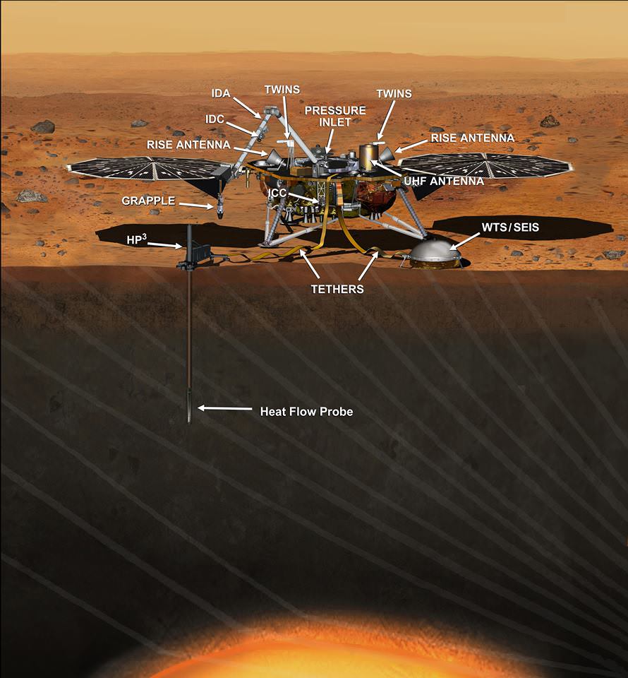
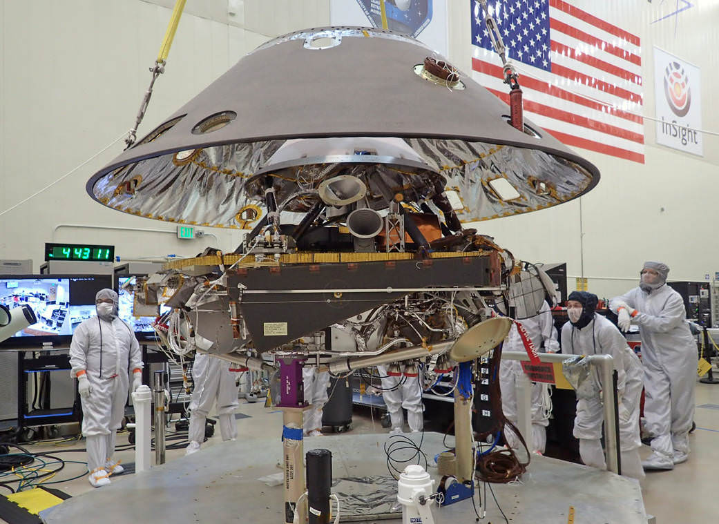
This artist's concept depicts the InSight lander on Mars after the lander's robotic arm has deployed a seismometer and a heat probe directly onto the ground. InSight is the first mission dedicated to investigating the deep interior of Mars. The findings will advance understanding of how all rocky planets, including Earth, formed and evolved. NASA approved a new launch date in May 2018. Credits: NASA/JPL-Caltech
This artist’s concept depicts the InSight lander on Mars after the lander’s robotic arm has deployed a seismometer and a heat probe directly onto the ground. InSight is the first mission dedicated to investigating the deep interior of Mars. The findings will advance understanding of how all rocky planets, including Earth, formed and evolved. NASA approved a new launch date in May 2018. Credits: NASA/JPL-Caltech
Top NASA managers have formally approved the launch of the agency’s InSight Lander to the Red Planet in the spring of 2018 following a postponement from this spring due to the discovery of a vacuum leak in a prime science instrument supplied by France.
The InSight missions goal is to accomplish an unprecedented study of the deep interior of the most Earth-like planet in our solar system.
NASA is now targeting a new launch window that begins May 5, 2018, for the Interior Exploration using Seismic Investigations, Geodesy and Heat Transport (InSight). mission aimed at studying the deep interior of Mars. The Mars landing is now scheduled for Nov. 26, 2018.
InSight had originally been slated for blastoff on March 4, 2016 atop a United Launch Alliance (ULA) Atlas V rocket from Vandenberg Air Force Base, California.
But the finding of a vacuum leak in its prime science instrument, the French-built Seismic Experiment for Interior Structure (SEIS), in December 2015 forced an unavoidable two year launch postponement. Because of the immutable laws of orbital mechanics, launch opportunities to the Red Planet only occur approximately every 26 months.
InSight’s purpose is to help us understand how rocky planets – including Earth – formed and evolved. The science goal is totally unique – to “listen to the heart of Mars to find the beat of rocky planet formation.”
The revised launch date was approved by the agency’s Science Mission Directorate.
“Our robotic scientific explorers such as InSight are paving the way toward an ambitious journey to send humans to the Red Planet,” said Geoff Yoder, acting associate administrator for NASA’s Science Mission Directorate, in Washington, in a statement.
“It’s gratifying that we are moving forward with this important mission to help us better understand the origins of Mars and all the rocky planets, including Earth.”
NASA’s InSight Mars lander spacecraft in a Lockheed Martin clean room near Denver. As part of a series of deployment tests, the spacecraft was commanded to deploy its solar arrays in the clean room to test and verify the exact process that it will use on the surface of Mars.
Since InSight would not have been able to carry out and fulfill its intended research objectives because of the vacuum leak in its defective SEIS seismometer instrument, NASA managers had no choice but to scrub this year’s launch. For a time its outlook for a future revival seemed potentially uncertain in light of today’s constrained budget environment.
The leak, if left uncorrected, would have rendered the flawed probe useless to carry out the unprecedented scientific research foreseen to measure the planets seismic activity and sense for “Marsquakes” to determine the nature of the Red Planet’s deep interior.
“The SEIS instrument — designed to measure ground movements as small as half the radius of a hydrogen atom — requires a perfect vacuum seal around its three main sensors in order to withstand harsh conditions on the Red Planet,” according to NASA.
The SEIS seismometer instrument was provided by the Centre National d’Études Spatiales (CNES) – the French national space agency equivalent to NASA. SEIS is one of the two primary science instruments aboard InSight. The other instrument measuring heat flow from the Martian interior is provided by the German Aerospace Center (DLR) and is named Heat Flow and Physical Properties Package (HP3). The HP3 instrument checked out perfectly.
NASA Jet Propulsion Laboratory (JPL) was assigned lead responsibility for the “replanned” mission and insuring that the SEIS instrument operates properly with no leaks.
JPL is “redesigning, developing and qualifying the instrument’s evacuated container and the electrical feedthroughs that failed previously. France’s space agency, the Centre National d’Études Spatiales (CNES), will focus on developing and delivering the key sensors for SEIS, integration of the sensors into the container, and the final integration of the instrument onto the spacecraft.”
“We’ve concluded that a replanned InSight mission for launch in 2018 is the best approach to fulfill these long-sought, high-priority science objectives,” said Jim Green, director of NASA’s Planetary Science Division.
The cost of the two-year delay and instrument redesign amounts to $153.8 million, on top of the original budget for InSight of $675 million.
NASA says this cost will not force a delay or cancellation to any current missions. However, “there may be fewer opportunities for new missions in future years, from fiscal years 2017-2020.”
Back shell of NASA’s InSight spacecraft is being lowered onto the mission’s lander, which is folded into its stowed configuration. The back shell and a heat shield form the aeroshell, which will protect the lander as the spacecraft plunges into the upper atmosphere of Mars. Launch now rescheduled to May 2018 to fix French-built seismometer. Credit: NASA/JPL-Caltech/Lockheed Martin
Lockheed Martin is the prime contractor for InSight and placed the spacecraft in storage while SEIS is fixed.
InSight is funded by NASA’s Discovery Program of low cost, focused science missions along with the science instrument funding contributions from France and Germany.
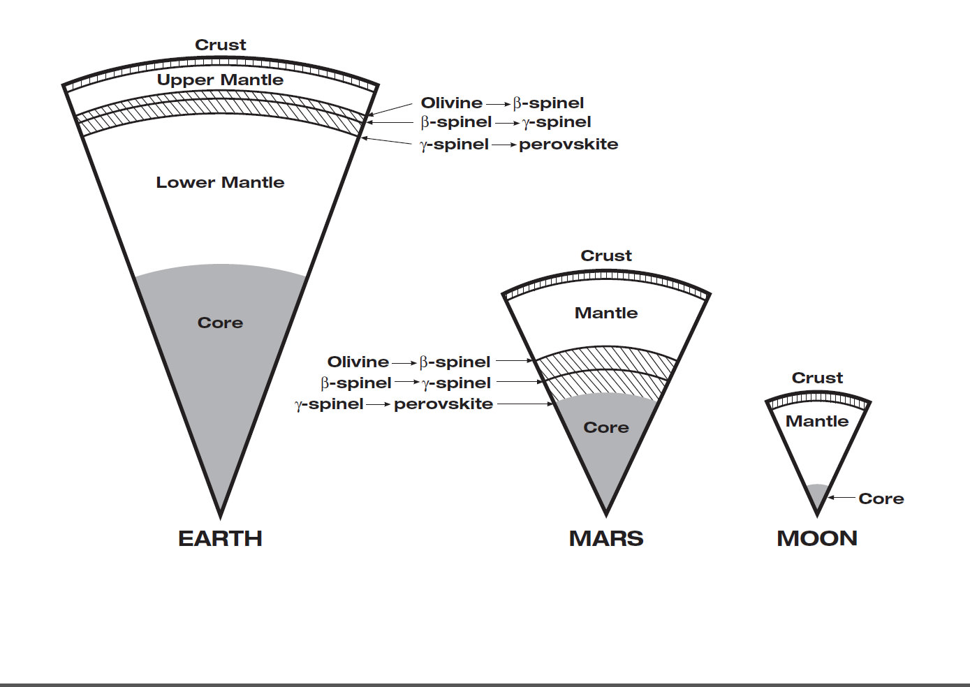
Mars has the same basic internal structure as the Earth and other terrestrial (rocky) planets. It is large enough to have pressures equivalent to those throughout the Earth’s upper mantle, and it has a core with a similar fraction of it’s mass. In contrast, the pressure even near the center of the Moon barely reach that just below the Earth’s crust and it has a tiny, almost negligible core. The size of Mars indicates that it must have undergone many of the same separation and crystallization processes that formed the Earth’s crust and core during early planetary formation. Credit: JPL/NASA
Learn more about OSIRIS-REx, InSight Mars lander, SpaceX missions, Juno at Jupiter, SpaceX CRS-9 rocket launch, ISS, ULA Atlas and Delta rockets, Orbital ATK Cygnus, Boeing, Space Taxis, Mars rovers, Orion, SLS, Antares, NASA missions and more at Ken’s upcoming outreach events:
Sep 6-8: “OSIRIS-REx lainch, SpaceX missions/launches to ISS on CRS-9, Juno at Jupiter, ULA Delta 4 Heavy spy satellite, SLS, Orion, Commercial crew, Curiosity explores Mars, Pluto and more,” Kennedy Space Center Quality Inn, Titusville, FL, evenings
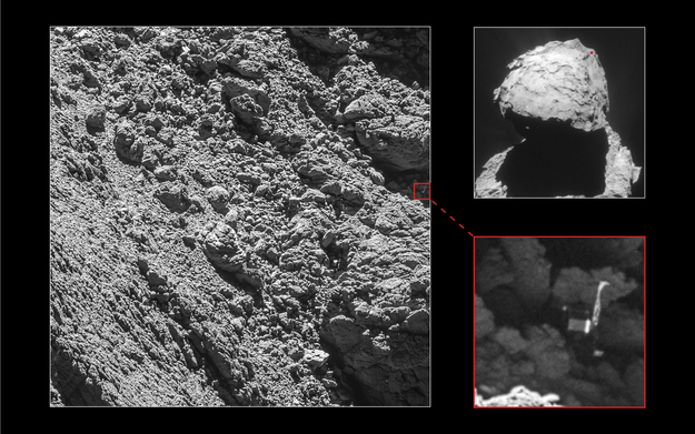
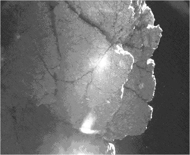
Philae has been found! Credit: Main image and lander inset: ESA/Rosetta/MPS for OSIRIS Team MPS/UPD/LAM/IAA/SSO/INTA/UPM/DASP/IDA; context: ESA/Rosetta/ NavCam.
The search is over, and looking at these images, no wonder it was so hard to find the little Philae lander!
The high-resolution camera on board the Rosetta spacecraft has finally spotted Philae “wedged into a dark crack on Comet 67P/Churyumov-Gerasimenko,” the ESA team said. They also said that now, seeing the lander’s orientation, it’s clear why establishing communications was so difficult following its landing on November 12, 2014.
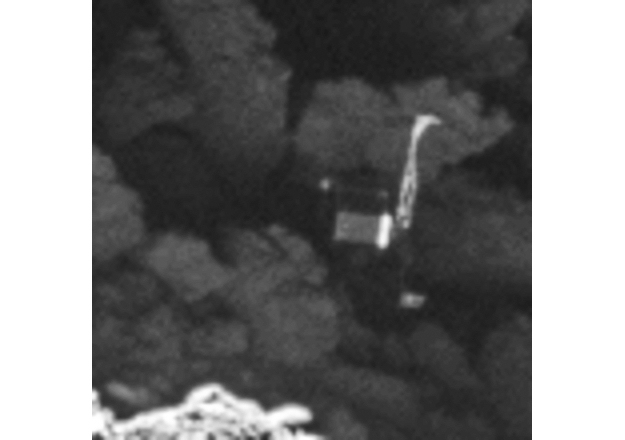
Close-up of the Philae lander. Credits: ESA/Rosetta/MPS for OSIRIS Team MPS/UPD/LAM/IAA/SSO/INTA/UPM/DASP/IDA
Rosetta, orbiting the comet and getting ready for its own demise/touchdown on 67P, focused its OSIRIS narrow-angle camera towards a few candidate sites on September 2, 2016 as the orbiter came just 2.7 km of the comet’s surface. Clearly visible in the zoomed in versions are the main body of the lander, along with two of its three legs.
“With only a month left of the Rosetta mission, we are so happy to have finally imaged Philae, and to see it in such amazing detail,” says Cecilia Tubiana of the OSIRIS camera team, the first person to see the images when they were downlinked from Rosetta on September 4.
Tubiana told Universe Today via email that Philae wasn’t too hard to find in the images. “Philae was in hiding in shadow, and as soon as we stretched the brightness to ‘see’ into the shadow, Philae was there!”
She added that nothing else about Philae’s condition has been revealed from the images so far.
The Philae lander was last seen after it first touched down at a region called Agilkia on the odd-shaped, two-lobed comet 67P. During its dramatic touchdown, the lander flew, landed, bounced and then repeated that process for more than two hours across the surface, with three or maybe four touchdowns. The harpoons that were to anchor Philae to the surface failed to fire, and scientists estimated the lander may have bounced as high as 3.2 kilometers (2 miles) before becoming wedged in the shadows of a cliff on the comet. After three days, Philae’s primary battery ran out of power and the lander went into hibernation, only to wake up again and communicate briefly with Rosetta in June and July 2015 as the comet came closer to the Sun and more power was available.
Philae’s final location had been plotted but until yesterday, never actually seen by Rosetta’s cameras. Radio ranging data was used to narrow down the search to an area spanning a few tens of meters, and a number of potential candidate objects were identified in relatively low-resolution images taken from larger distances.
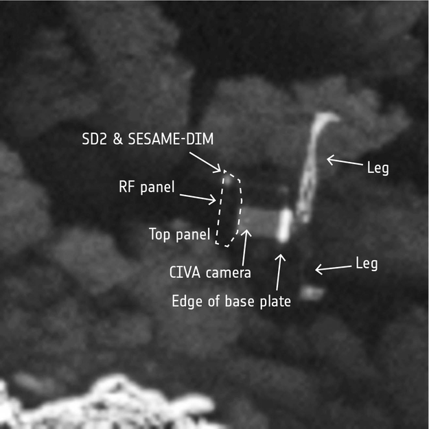
Philae close-up, labelled. Credits: ESA/Rosetta/MPS for OSIRIS Team MPS/UPD/LAM/IAA/SSO/INTA/UPM/DASP/IDA.
Compare some of the features of the cliff in the image above to this image taken by Philae of its surroundings:
The Philae lander captured a picture of a nearby cliff, nicknamed “Perihelion Cliff”, on the nucleus of Comet 67P/Churyumov-Gerasimenko. Credit: ESA/Rosetta/Philae/CIVA.
“After months of work, with the focus and the evidence pointing more and more to this lander candidate, I’m very excited and thrilled that we finally have this all-important picture of Philae sitting in Abydos,” said ESA’s Laurence O’Rourke, who has been coordinating the search efforts over the last months at ESA, with the OSIRIS and SONC/CNES teams.
At 2.7 km, the resolution of the OSIRIS narrow-angle camera is about 5 cm/pixel, which is sufficient to reveal features of Philae’s 1 m-sized body and its legs.
“This wonderful news means that we now have the missing ‘ground-truth’ information needed to put Philae’s three days of science into proper context, now that we know where that ground actually is!” says Matt Taylor, ESA’s Rosetta project scientist.
An OSIRIS narrow-angle camera image taken on 2 September 2016 from a distance of 2.7 km in which Philae was definitively identified. The image has been processed to adjust the dynamic range in order to see Philae while maintaining the details of the comet’s surface. Philae is located at the far right of the image, just above center. The image scale is about 5 cm/pixel. Credits: ESA/Rosetta/MPS for OSIRIS Team MPS/UPD/LAM/IAA/SSO/INTA/UPM/DASP/IDA.
The discovery comes less than a month before Rosetta descends to the comet’s surface. On September 30, the orbiter will be sent on a final one-way mission to investigate the comet from close up, including the open pits in a region called Ma’at, where it is hoped that critical observations will help to reveal secrets of the body’s interior structure.
“Now that the lander search is finished we feel ready for Rosetta’s landing, and look forward to capturing even closer images of Rosetta’s touchdown site,” adds Holger Sierks, principal investigator of the OSIRIS camera.
The Rosetta team said they would be providing more details about the search as well as more images in the near future.