Pluto’s Majestic Mountains, Frozen Plains and Foggy Hazes: Just 15 minutes after its closest approach to Pluto on July 14, 2015, NASA’s New Horizons spacecraft looked back toward the sun and captured this near-sunset view of the rugged, icy mountains and flat ice plains extending to Pluto’s horizon. The smooth expanse of the informally named icy plain Sputnik Planum (right) is flanked to the west (left) by rugged mountains up to 11,000 feet (3,500 meters) high, including the informally named Norgay Montes in the foreground and Hillary Montes on the skyline. To the right, east of Sputnik, rougher terrain is cut by apparent glaciers. The backlighting highlights over a dozen layers of haze in Pluto’s tenuous but distended atmosphere. The image was taken from a distance of 11,000 miles (18,000 kilometers) to Pluto; the scene is 780 miles (1,250 kilometers) wide.
Credits: NASA/JHUAPL/SwRI
As the hazy, lazy days of summer come to a close, the New Horizons team released a brand new set of incredible images of a very atmospheric Pluto.
Can you believe the detail in these photos? Back-lit by the Sun, we see icy plains, rugged mountains, glacier-cut terrain and multiple layers of haze just like those on a steamy August afternoon.
Just look at those pyramidal mountain peaks right next to those relatively smooth, icy plains. The backlighting highlights more than a dozen layers of haze in Pluto’s tenuous but distended atmosphere. The image was taken from a distance of 11,000 miles (18,000 km) to Pluto; the scene is 230 miles (380 km) across. Credits: NASA/JHUAPL/SwRI)
The scene measures 780 miles (1,250 kilometers) across and was taken from a distance of 11,000 miles (18,000 km) on July 15 just after closest approach. Because backlighting highlights fine aerosols suspended in the atmosphere (think of seeing your breath on a cold winter day against the Sun), these photos show the amazing complexity of Pluto’s atmosphere with more than a dozen thin haze layers extending from near the ground to at least 60 miles (100 km) above the surface.
In this small section of the larger crescent image of Pluto, the setting sun illuminates a bank of fog or low-lying near-surface haze sliced by the parallel shadows of many local hills and small mountains. The image was taken from a distance of 11,000 miles (18,000 km), and the width of the image is 115 miles (185 km). Credits: NASA/JHUAPL/SwRI
“This image really makes you feel you are there, at Pluto, surveying the landscape for yourself,” said New Horizons Principal Investigator Alan Stern in a press release today. “But this image is also a scientific bonanza, revealing new details about Pluto’s atmosphere, mountains, glaciers and plains.”
Sputnik Planum is the informal name of the smooth, light-bulb shaped region on the left of this composite of several New Horizons images of Pluto. The brilliantly white upland region to the right may be coated by nitrogen ice that has been transported through the atmosphere from the surface of Sputnik Planum, and deposited on these uplands. The box shows the location of the glacier detail images below. Credits: NASA/JHUAPL/SwRI
I find the hazes the most amazing aspect of the photos. They remind me of crepuscular rays, those beams of sunshine that shine between breaks in the clouds near sunset and sunrise. It chills and thrills me to the bone to see such earthly sights on a bitterly cold orb more than 3 billion miles from home.
Ice, probably frozen nitrogen, appears to have accumulated on the uplands on the right side of this 390-mile (630-km) wide image is draining from Pluto’s mountains onto the informally named Sputnik Planum through the 2- to 5-mile (3- to 8-km) wide valleys indicated by the red arrows. On Earth this would be considered a valley glacier. The flow front of the ice moving into Sputnik Planum is outlined by the blue arrows. The origin of the ridges and pits on the right side of the image remains uncertain. Credits: NASA/JHUAPL/SwRI
But that’s not all that’s close to our hearts on Pluto. The photos reveal nitrogen ice apparently flowing downhill from mountainous highlands into a broad, smooth basin. Combined with other recently downloaded pictures, this new image (above) provides evidence for a remarkably Earth-like “hydrological” cycle on Pluto – but involving soft and exotic ices, including nitrogen, rather than water ice.
This might be the most remarkable image of all. It covers the same region as the image above, but is re-projected from the oblique, backlit view shown in the new crescent image of Pluto. The backlighting highlights the intricate flow lines on the valley glaciers. The flow front of the ice moving into the informally named Sputnik Planum is outlined by the blue arrows. We’re looking at a scene 390 miles (630 km) across. Credits: NASA/JHUAPL/SwRI
Nitrogen ice in the vast, relatively smooth Sputnik Planum may have vaporized in sunlight and then redeposited as ice in the bright, rugged region to its east. The new Ralph imager panorama also reveals glaciers flowing back from the blanketed mountain region into Sputnik Planum; these features are similar to the frozen streams on the margins of ice caps on Greenland and Antarctica.
Who knew that by going to Pluto we’d see such familiarity? But there you have it.
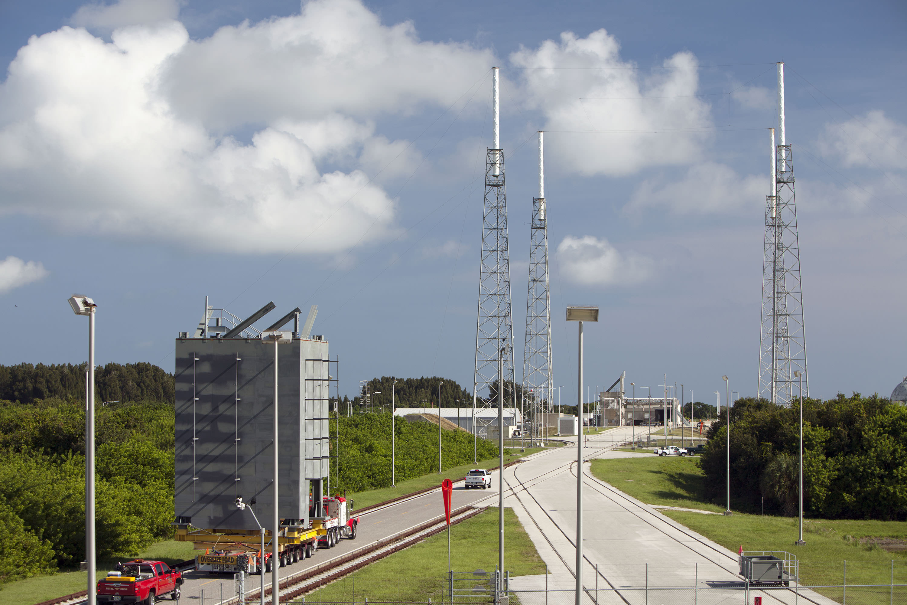
The first tier of seven tiers for Crew Access Tower is moved from its construction yard to Space Launch Complex-41 at Cape Canaveral Air Force Station in Florida. The tower will provide access at the pad for astronauts and ground support teams to the Boeing CST-100 Starliner launching atop a United Launch Alliance Atlas V rocket. Photo credit: NASA/Dmitrios Gerondidakis
The first tier of seven tiers for Crew Access Tower is moved from its construction yard to Space Launch Complex-41 at Cape Canaveral Air Force Station in Florida on Sept 9, 2015. The tower will provide access at the pad for astronauts and ground support teams to the Boeing CST-100 Starliner launching atop a United Launch Alliance Atlas V rocket. Photo credit: NASA/Dmitrios Gerondidakis Story/photos updated[/caption]
“Everything is on schedule,” Howard Biegler, ULA’s Human Launch Services Lead, told Universe Today during an exclusive interview. “The new 200-foot-tall tower structure goes up rather quickly at launch pad 41.”
The access tower essentially functions as the astronauts walkway to the stars.
“We start stacking the crew access tower [CAT] after the MUOS-4 launch and prior to the next launch after that of Morelos-3,” Beigler said in a wide ranging interview describing the intricately planned pad modifications and tower construction at the Atlas V Space Launch Complex 41 facility at Cape Canaveral.
Depending on the always tricky weather at the Cape, more than half the tower should be “installed prior to MORELOS-3’s launch on Oct. 2. The balance of the CAT will take form after the launch.”
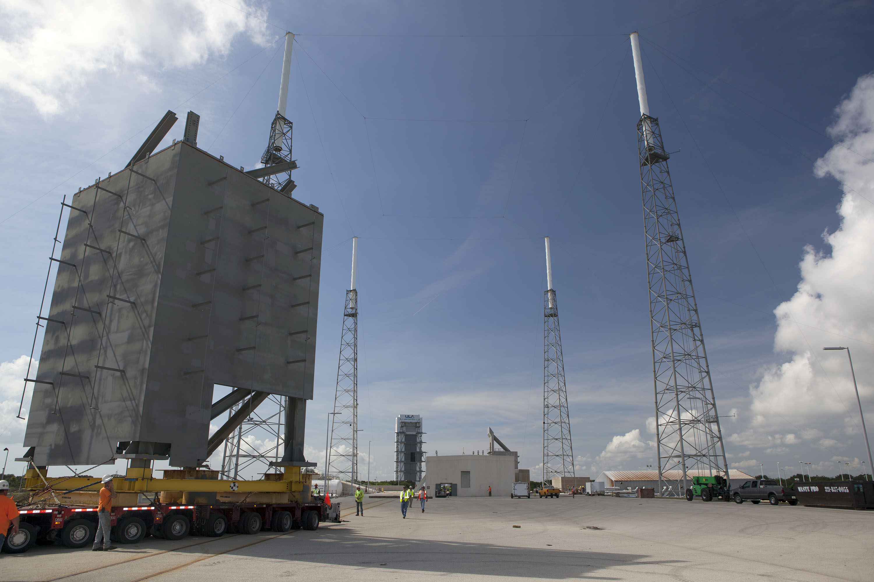
The first tier of the new Crew Access Tower for the Boeing CST-100 Starliner arrives at Space Launch Complex-41 at Cape Canaveral Air Force Station in Florida on Sept 9, 2015. The tower will provide access at the pad for astronauts and ground support teams to the Boeing CST-100 Starliner launching atop a United Launch Alliance Atlas V rocket. Photo credit: NASA/Dmitrios Gerondidakis
The crew access tower is a critical space infrastructure element and absolutely essential for getting Americans back to space on American rockets for the first time since NASA’s shuttles were retired in 2011. That action forced our total dependence on the Russian Soyuz capsule for astronaut ridesto the space station.
Boeing was awarded a $4.2 Billion contract in September 2014 by NASA Administrator Charles Bolden to complete development and manufacture of the CST-100 space taxi under the agency’s Commercial Crew Transportation Capability (CCtCap) program and NASA’s Launch America initiative. SpaceX also received a NASA award worth $2.6 Billion to build the Crew Dragon spacecraft for launch atop the firms man-rated Falcon 9 rocket.
Starliner is a key part of NASA’s overarching strategy to send Humans on a “Journey to Mars” in the 2030s.
The tower is of modular design for ease of assembly at the always busy Atlas launch pad.
“The crew tower is comprised of seven major tiers, or segments,” Beigler explained. “The building of the tiers went right on schedule. Each tier is about 20 feet square and 28 feet tall.”
Five of the seven tiers will be installed ahead of the next Atlas launch in early October, depending on the weather which has been difficult at the Cape.
“Our plan is to get 5 tiers and a temporary roof installed prior to MORELOS-3’s launch on October 2.”
“We have been hit hard with weather and are hopeful we can gain some schedule through the weekend. The balance of the CAT will take form after the 10/2 launch with the 7th tier planned to go up on 10/13 and roof on 10/15,” Biegler explained.
The first tier of the new Crew Access Tower for the Boeing CST-100 Starliner is installed at Space Launch Complex-41 at Cape Canaveral Air Force Station in Florida where United Launch Alliance Atlas V rockets will lift Boeing Starliners into orbit. Photo credit: NASA/Dmitrios Gerondidakis
The newly named ‘Starliner’ space taxi will launch atop a newly human-rated Atlas V booster as soon as mid-2017, say NASA, ULA and Boeing officials.
But before astronauts can even climb aboard Starliner atop the Atlas rocket, ULA and Boeing first had to design, build and install a brand new tower providing access to the capsule for the crews and technicians.
Pad 41 is currently a “clean pad” with no gantry and no walkway to ‘Starliner’ because the Atlas V has only been used for unmanned missions to date.
The CST-100 ‘Starliner’ is at the forefront of ushering in the new commercial era of space flight and will completely revolutionize how we access, explore and exploit space for the benefit of all mankind.
This is the first new Crew Access Tower to be built at the Cape in decades, going back to NASA’s heyday and the Apollo moon landing era.
The tier segments were assembled about four miles down the road at the Atlas Space Operations Center on Cape Canaveral – so as not to disrupt the chock full manifest of Atlas rockets launching on a breakneck schedule for the NASA, military and commercial customers who ultimately pay the bills to keep ULA afloat and launch groundbreaking science probes and the most critical national security payloads vital to national defense.
“Each segment was outfitted with additional steel work, as well as electrical, plumbing and the staircase. Then they will be transported 3.9 miles out to the pad, one at a time on a gold hoffer and then we start erecting.”
The first two tiers were just transported out to pad 41. Installation and stacking of one tier on top of another starts in a few days.
Artist’s concept of Boeing’s CST-100 space taxi atop a human rated ULA Atlas-V rocket showing new crew access tower and arm at Space Launch Complex 41, Cape Canaveral Air Force Station, Fl. Credit: ULA/Boeing
“We are very pleased with the progress so far,” Biegler told me. “Everything is on schedule and has gone remarkably well so far. No safety or workmanship issues. It’s all gone very well.”
“The first tier is obviously the most critical [and will take a bit longer than the others to insure that everything is being done correctly]. It has to be aligned precisely over the anchor bolts on the foundation at the pad. Then it gets bolted in place.”
“After that they can be installed every couple of days, maybe every three days or so. The pieces of the tower will go up quickly.”
Artist’s concept of Boeing’s CST-100 space taxi atop a human rated ULA Atlas-V rocket showing new crew access tower and arm. Credit: ULA/BoeingThe steel tiers and tower are being built by Hensel Phelps under contract to ULA.
“Construction by the Hensel Phelps team started in January 2015,” Biegler said.
Erecting the entire tower is the next step. After stacking the tiers is fully completed later this year then comes structure, testing and calibration work over the next year.
“After tower buildup comes extensive work to outfit the tower with over 400 pieces of outboard steel that have to be installed. That takes much longer,” Biegler said.
“Designed with modern data systems, communications and power networks integrated and protected from blast and vibration, plus an elevator, the Crew Access Tower has been built with several features only a fully suited astronaut could appreciate, such as wider walkways, snag-free railings and corners that are easy to navigate without running into someone,” according to NASA officials.
Just like the shuttle, “the tower will also be equipped with slide wire baskets for emergency evacuation to a staged blast-resistant vehicle.”
“At the very top is the area that protects the access arm and provides the exit location for the emergency egress system. It will all be stick built from steel out at the pad,” Biegler elaborated.
The access arm with the walkway that astronauts will traverse to the Starliner capsule is also under construction. It is about 180 feet above ground.
Astronauts will ride an elevator up the tower to the access arm, and walk through it to the white room at the end to board the Starliner capsule.
“The arm along with the white room and torque tube are being fabricated in Florida. It will all be delivered to the pad sometime around next June [2016],” Biegler stated.
“We built a test stand tower for the access arm at our Oak Hill facility to facilitate the installation process. We mount the arm and the hydraulic drive system and then run it through its paces prior to its delivery to the pad.”
“The access arm – including the torque tube out to the end – is just over 40 feet in length.”
“We will integrate it off line because we don’t have a lot of time to troubleshoot out at the pad. So we will hook up all its drive systems and electronics on the test structure stand.”
“Then we will spend about 3 months testing it and verifying that everything is right. We’ll use laser lining to know it all precisely where the arm is. So that when we bring it out to the pad we will know where it is to within fractions of an inch. Obviously there will be some minor adjustments up and down.”
“That way in the end we will know that everything in the arm and the hydraulic drive system are working within our design specs.”
When the arm is finally installed on the crew access tower it will be complete, with the white room and environmental seal already attached.
“It will stow under the crew access tower, which is located west and north of the launch vehicle. The arm will swing out about 120 degrees to the crew module to gain access and was strategically picked to best fit the features and foundation at the existing pad structure.”
Tower construction takes place in between Atlas launches and pauses in the days prior to launches. For example the construction team will stand down briefly just ahead of the next Atlas V launch currently slated for Oct. 2 with the Mexican governments Morelos-3 communications satellite.
The Crew Access Tower is now being erected at Pad 41 following MUOS-4 blastoff here. MUOS-4 US Navy communications satellite and Atlas V rocket at pad 41 at Cape Canaveral Air Force Station, FL for launch on Sept. 2, 2015 at 5:59 a.m. EDT. Credit: Ken Kremer/kenkremer.com
Starliners’ actual launch date totally depends on whether the US Congress provides full funding for NASA’s commercial crew program (CCP).
Thus far the Congress has totally failed at providing the requested CCP budget to adequately fund the program – already causing a 2 year delay of the first flight from 2015 to 2017.
Boeing is making great progress on manufacturing the first CST-100 Starliner.
Barely a week ago, Boeing staged the official ‘Grand Opening’ ceremony for the craft’s manufacturing facility held at the Kennedy Space Center on Friday, Sept 4. 2015 – attended by Universe Today as I reported here.
ULA has also already started assembly of the first two Atlas V rockets designated for Starliner at their rocket factory in Decatur, Alabama.
Read my earlier exclusive, in depth one-on-one interviews with Chris Ferguson – America’s last shuttle commander, who now leads Boeings’ CST-100 program; here and here.
First view of the Boeing CST-100 ‘Starliner’ crewed space taxi at the Sept. 4, 2015 Grand Opening ceremony held in the totally refurbished C3PF manufacturing facility at NASA’s Kennedy Space Center. These are the upper and lower segments of the first Starliner crew module known as the Structural Test Article (STA) being built at Boeing’s Commercial Crew and Cargo Processing Facility (C3PF) at KSC. Credit: Ken Kremer /kenkremer.com
Stay tuned here for Ken’s continuing Earth and planetary science and human spaceflight news.
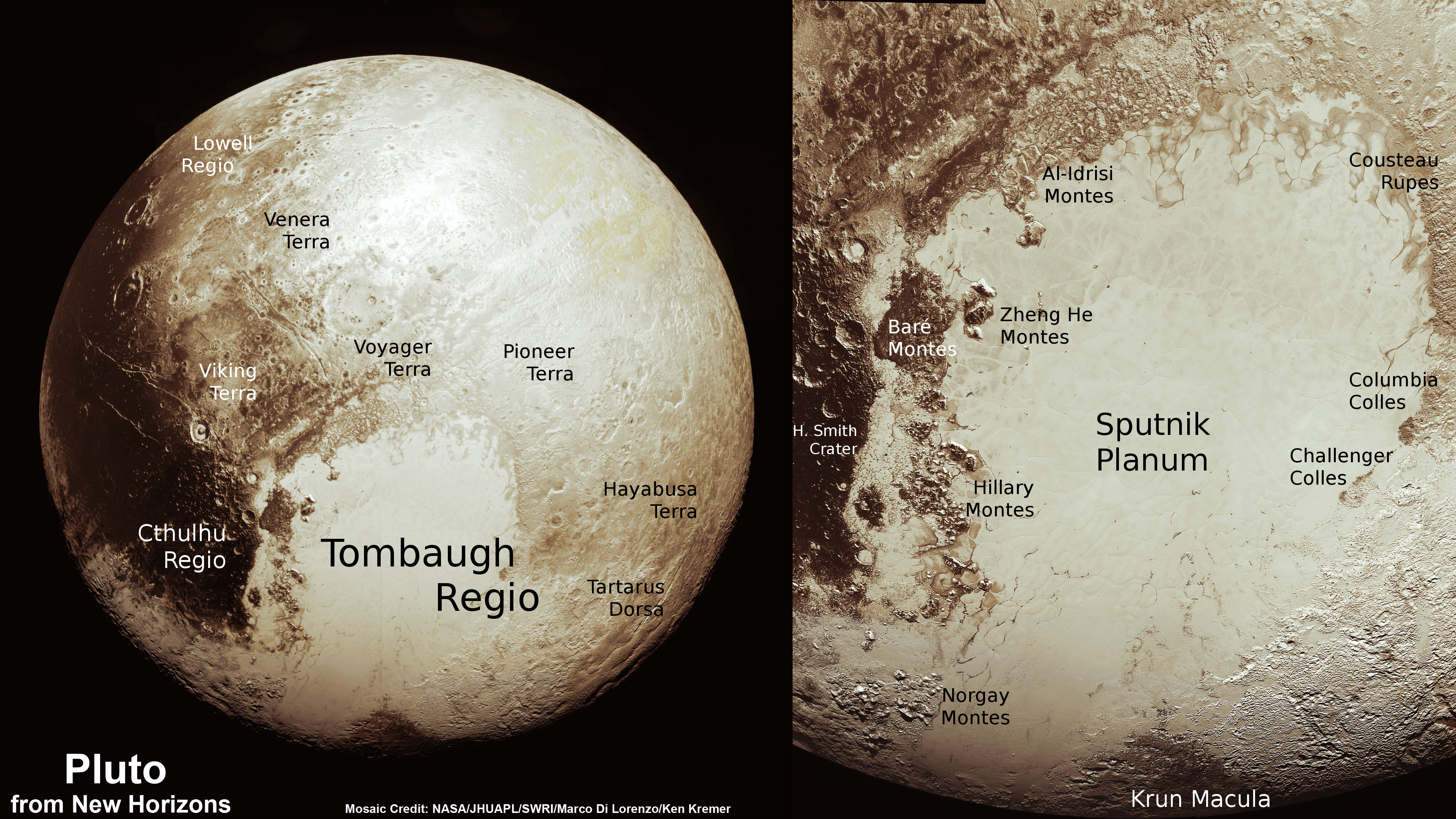
This new global mosaic view of Pluto was created from the latest high-resolution images to be downlinked from NASA’s New Horizons spacecraft and released on Sept. 11, 2015. The images were taken as New Horizons flew past Pluto on July 14, 2015, from a distance of 50,000 miles (80,000 kilometers). This new mosaic was stitched from over two dozen raw images captured by the LORRI imager and colorized. Credits: NASA/Johns Hopkins University Applied Physics Laboratory/Southwest Research Institute/Marco Di Lorenzo/Ken Kremer/kenkremer.com
This new global mosaic view of Pluto was created from the latest high-resolution images to be downlinked from NASA’s New Horizons spacecraft and released on Sept. 11, 2015. The images were taken as New Horizons flew past Pluto on July 14, 2015, from a distance of 50,000 miles (80,000 kilometers). This new mosaic was stitched from over two dozen raw images captured by the LORRI imager and colorized. Credits: NASA/Johns Hopkins University Applied Physics Laboratory/Southwest Research Institute/Marco Di Lorenzo/Ken Kremer/kenkremer.com
See annotated version and new hi res Tombaugh Regio mosaic below[/caption]
But because of limited bandwidth the new image data sets were stored onboard the probe until days ago when they were transmitted back to Earth and released by the New Horizons team late in the day on Friday, Sept. 11.
This best yet view of far flung Pluto comes from raw images taken as New Horizons conducted the history making first flyby past Pluto on July 14, 2015, at a distance of 50,000 miles (80,000 kilometers).
The global Pluto mosaic was generated from over two dozen raw images captured by New Horizons’ Long Range Reconnaissance Imager (LORRI) and stitched together by the image processing team of Marco Di Lorenzo and Ken Kremer.
See also our expanded hi res Tombaugh Regio mosaic below showing features as small as 0.5 miles (0.8 kilometers) in size.
After transmitting carefully selected high priority images and science measurements across over 3 billion miles (about 5 billion kilometers) of interplanetary space in the days around the history making flyby, the team elected to temporarily pause the transmission of new images for several weeks in favor of sending other data important for helping place the entire Pluto planetary system into context.
Altogether, over 50 gigabits of data were collected during the July 14 encounter and flyby periods of the highest scientific activity – which includes the most critical hours before and after the spacecrafts closest approach to Pluto, its largest moon Charon and its quartet of smaller moons.
Highest resolution mosaic of ‘Tombaugh Regio’ shows the heart-shaped region on Pluto including ice flows and plains of ‘Sputnik Planum’ (center) and icy mountain ranges of ‘Hillary Montes’ and ‘Norgay Montes.’ This new mosaic combines the eleven highest resolution images captured by NASA’s New Horizons LORRI imager during history making closest approach flyby on July 14, 2015. It shows features as small as 0.5 miles (0.8 kilometers) in size. Credit: NASA/JHUAPL/SWRI/Ken Kremer/kenkremer.com/Marco Di Lorenzo
Data from the flyby continues streaming back to Earth, but rather slowly due to limited bandwidth amounting to an average “downlink” of only about 2 kilobits per second via its two transmitters.
New Horizon’s unveiled Pluto as a surprising vibrant and geologically active “icy world of wonders” as it barreled past the Pluto-Charon double planet system on July 14 at over 31,000 mph (49,600 kph) and collected unprecedented high resolution imagery and spectral measurements of the utterly alien worlds.
Since the flyby, the team has been busy analyzing the science data returned thus far and “making some discoveries” said New Horizons Principal Investigator Alan Stern of the Southwest Research Institute, Boulder, Colorado, during the Weekly Space Hangout on Sept 11.
The team is ecstatic with all the new images and created what they call a synthetic global view of a portion of Pluto.
“We created a synthetic global mosaic view of more than a dozen frames from the LORRI camera, and wrapped it on a sphere and then projected the view as if you were suspended about a thousand miles above the planet – looking back.”
Each LORRI frame is about 400 km across.
This new mosaic of Pluto is from the latest high-resolution images sent to Earth from the New Horizons spacecraft shows what you would see if you were approximately 1,100 miles (1,800 kilometers) above Pluto’s equatorial area, looking northeast over the dark, cratered, informally named Cthulhu Regio toward the bright, smooth, expanse of icy plains informally called Sputnik Planum. The entire expanse of terrain seen in this image is 1,100 miles (1,800 kilometers) across. The images were taken as New Horizons flew past Pluto on July 14, 2015, from a distance of 50,000 miles (80,000 kilometers). Credit: NASA/Johns Hopkins University Applied Physics Laboratory/Southwest Research Institute
“It gives a breathtaking view of how diverse the geology is and also how diverse the seasonal volatile transport must be across the surface.”
“It’s just absolutely magical and breathtaking. There is a lot going on there.”
“The big bright area on the left side of the heart shaped feature is informally called Sputnik Planum after the first spacecraft – Sputnik. Surrounding the Texas sized plain are steep mountain ranges that are as tall as the Rockies in Colorado.”
What are Pluto’s plains and mountains comprised of?
“We know that the mountain ranges are not made of the same stuff as the planum, or plains. The plains are made of nitrogen. But nitrogen is too soft a material to build mountains out of, even in Pluto’s weak gravity.”
“So the mountains must be made of something else stronger. Rock and water ice are the two most likely possibilities. But they are most likely water ice, the lighter stuff. Because the rock has almost certainly sunk to the center of Pluto and the ice has floated to the top and formed the mantle and perhaps the crust of Pluto.”
“So we think the volatiles like the nitrogen, methane and carbon monoxide you see there and that shifts around with the seasons and interacts with the atmosphere – is just a veneer. It’s just a coating on the surface. And in some places its very thin and looks like it is breaking up on the margins. In other places it may be quite thick, maybe even kilometers thick.”
“We’ll see when we have more data!” exclaimed Stern.
“The data downlink will take over a year to get all the data to the ground [on Earth].”
“Over 50 gigabits of science data from the Pluto system needs to be sent back. The Pluto flyby took place on the 50th anniversary of NASA’s first flyby of Mars by Mariner IV. New Horizons dataset amounted to several thousand times more data collected compared to what Mariner IV sent back during its first flyby of Mars,” Stern elaborated.
“The surface of Pluto is every bit as complex as that of Mars,” says Jeff Moore, leader of the New Horizons Geology, Geophysics and Imaging (GGI) team at NASA’s Ames Research Center in Moffett Field, California. “The randomly jumbled mountains might be huge blocks of hard water ice floating within a vast, denser, softer deposit of frozen nitrogen within the region informally named Sputnik Planum.”
How much data has been returned so far varies by instrument.
“The average across all the entire science payload is only about 5 or 6 percent so far,” Stern explained.
“All the flyby data from the two plasma instruments – PEPSI and SWAP – and the Student Dust Counter instrument is back on the ground, because they were small datasets.”
“But less than 3% of the ALICE UV spectrometer data is back so far. And for the other imaging instruments its similar.”
“So it’s going to take about another year to send all the data back!”
This new global mosaic view of Pluto was created from the latest high-resolution images to be downlinked from NASA’s New Horizons spacecraft and released on Sept. 11, 2015. The images were taken as New Horizons flew past Pluto on July 14, 2015, from a distance of 50,000 miles (80,000 kilometers). This new mosaic was stitched from over two dozen raw images captured by the LORRI imager and colorized. Annotated with informal place names. Credits: NASA/Johns Hopkins University Applied Physics Laboratory/Southwest Research Institute/Marco Di Lorenzo/Ken Kremer/kenkremer.com
Stern informed that the team has submitted a paper to the journal Science and plans a large series of technical scientific presentations at upcoming meetings, including the Division of Planetary Sciences Meeting in Washington in November.
And New Horizons is in excellent shape to get those 50 gigabits of data back to the eagerly waiting researchers since all the spacecraft systems are operating normally.
“The spacecraft is doing very well,” said Alice Bowman, New Horizons Mission Operations Manager of the Johns Hopkins University Applied Physics Laboratory (APL), during the Weekly Space Hangout.
“It’s very healthy and we are getting back gobs of data – causing a flurry of emails among the science team.”
“It’s been a good ride and we had a good flyby of Jupiter too [along the way].”
This new global mosaic view of Pluto was created from the latest high-resolution images to be downlinked from NASA’s New Horizons spacecraft and released on Sept. 11, 2015. The images were taken as New Horizons flew past Pluto on July 14, 2015, from a distance of 50,000 miles (80,000 kilometers). This mosaic was stitched from over two dozen raw images captured by the LORRI imager and colorized. Right side mosaic comprises twelve highest resolution views of Tombaugh Regio heart shaped feature and shows objects as small as 0.5 miles (0.8 kilometers) in size. Credits: NASA/Johns Hopkins University Applied Physics Laboratory/Southwest Research Institute/ Ken Kremer/kenkremer.com/Marco Di Lorenzo
New Horizons also discovered that Pluto is the largest known body beyond Neptune – and thus reigns as the “King of the Kuiper Belt!”
As of today, Sept. 14, New Horizons is 2 months past the Pluto flyby and already over 73 million kilometers ( over 45 million miles) beyond Pluto and continuing its journey into the Kuiper Belt, the third realm of worlds in our solar system.
The science team plans to target New Horizons to fly by another much smaller Kuiper Belt Object (KBO) in 2019 after recently selecting the object dubbed PT1, for Potential Target 1, based on images taken by NASA’s Hubble Space Telescope.
“Since the flyby, we have been planning for the extended mission which we will propose to NASA next year,” Stern explained. NASA will then decide whether to approve and fund the new KBO mission proposal.
“We expect to do an engine burn for that [new KBO target] next month [in October]. The KBO flyby will take place about a billion miles beyond Pluto at about 44 AU.”
The actual flyby distance of New Horizons from the KBO is yet to be determined. Stern thinks it could perhaps be much closer, but all those details still need to be worked out.
NASA Associate Administrator for the Science Mission Directorate John Grunsfeld, left, New Horizons Principal Investigator Alan Stern of Southwest Research Institute (SwRI), Boulder, CO, second from left, New Horizons Mission Operations Manager Alice Bowman of the Johns Hopkins University Applied Physics Laboratory (APL), second from right, and New Horizons Project Manager Glen Fountain of APL, right, are seen at the conclusion of a press conference after the team received confirmation from the spacecraft that it has completed the flyby of Pluto, Tuesday, July 14, 2015 at the Johns Hopkins University Applied Physics Laboratory (APL) in Laurel, Maryland. Credit: Ken Kremer/kenkremer.com
Watch for Ken’s continuing coverage of the Pluto flyby. He was onsite reporting live on the flyby and media briefings for Universe Today from the Johns Hopkins University Applied Physics Laboratory (APL), in Laurel, Md.
Stay tuned here for Ken’s continuing Earth and planetary science and human spaceflight news.
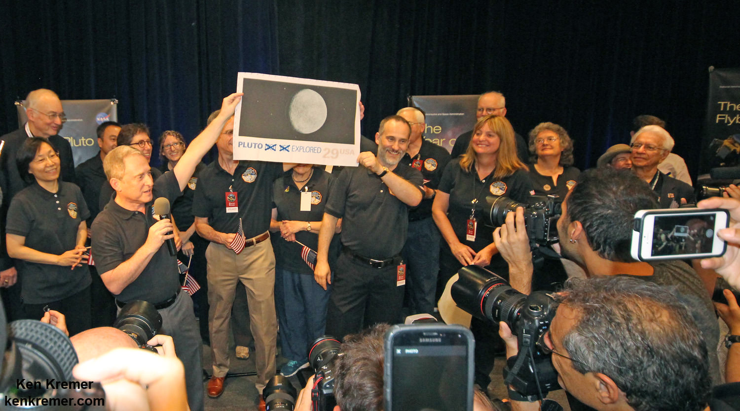
Pluto Explored at Last
The New Horizons mission team celebrates successful flyby of Pluto in the moments after closest approach at 7:49 a.m. EDT on July 14, 2015. New Horizons Principal Investigator Alan Stern of Southwest Research Institute (SwRI), Boulder, CO., left, Johns Hopkins University Applied Physics Laboratory (APL) Director Ralph Semmel, center, and New Horizons Co-Investigator Will Grundy Lowell Observatory hold an enlarged print of an U.S. stamp with their suggested update after Pluto became the final planet in our solar system to be explored by an American space probe (crossing out the words ‘not yet’) – at the Johns Hopkins University Applied Physics Laboratory (APL) in Laurel, Maryland. Credit: Ken Kremer/kenkremer.comHighest resolution mosaic of ‘Tombaugh Regio’ shows the heart-shaped region on Pluto focusing on ice flows and plains of ‘Sputnik Planum’ at top and icy mountain ranges of ‘Hillary Montes’ and ‘Norgay Montes’ below. This new mosaic combines the seven highest resolution images captured by NASA’s New Horizons LORRI imager during history making closest approach flyby on July 14, 2015. Inset at right shows global view of Pluto with location of mosaic and huge heart-shaped region in context. Annotated with place names. Credit: NASA/JHUAPL/SWRI/ Marco Di Lorenzo/Ken Kremer/kenkremer.comThis new global mosaic view of Pluto was created from the latest high-resolution images to be downlinked from NASA’s New Horizons spacecraft and released on Sept. 11, 2015. The images were taken as New Horizons flew past Pluto on July 14, 2015, from a distance of 50,000 miles (80,000 kilometers). This new mosaic was stitched from over two dozen raw images captured by the LORRI imager and colorized. Right side inset from New Horizons team focuses on Tombaugh Regio heart shaped feature. Annotated with informal place names. Credits: NASA/Johns Hopkins University Applied Physics Laboratory/Southwest Research Institute/Marco Di Lorenzo/Ken Kremer/kenkremer.com
Large-scale crossbedding in the sandstone of this ridge on a lower slope of Mars' Mount Sharp is typical of windblown sand dunes that have petrified. NASA's Curiosity Mars rover used its Mastcam to capture this vista on Aug. 27, 2015, Sol 1087. Similarly textured sandstone is common in the U.S. Southwest. Credits: NASA/JPL-Caltech/MSSS
Large-scale crossbedding in the sandstone of this ridge on a lower slope of Mars’ Mount Sharp is typical of windblown sand dunes that have petrified. NASA’s Curiosity Mars rover used its Mastcam to capture this vista on Aug. 27, 2015, Sol 1087. Similarly textured sandstone is common in the U.S. Southwest. Credits: NASA/JPL-Caltech/MSSS
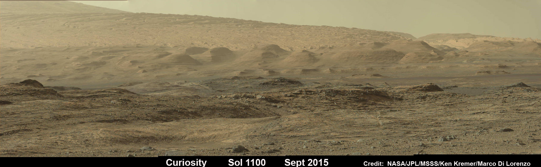
See Sol 1100 mosaic below [/caption]
NASA’s SUV-sized Curiosity rover has arrived at a beautiful Martian vista displaying a huge deposit of magnificently petrified sand dunes that look remarkably like some commonly found on Earth and native to the deserts of the U.S. Southwest.
The petrified sand dunes were discovered amongst an area of dark sandstone along a ridge at the lower slope of Mars’ Mount Sharp. They are now being explored in detail by the six wheeled rover in a geologic feature dubbed the Stimson unit.
“The team is considering where to drill next within the Stimson sandstone and we are looking for the best light toned areas to check for mineralogical signs of water-rock reaction,” says John Bridges, rover team member from the University of Leicester, England, in the latest mission update from today, September 12, 2015.
Curiosity looks toward fabulous canyons and buttes at the base of Mount Sharp from the Stimson sand dunes on Mars on Sol 1100, Sept. 10 2015 in this photo mosaic stitched from Mastcam color camera raw images. Credit: NASA/JPL/MSSS/Ken Kremer/kenkremer.com/Marco Di Lorenzo
Curiosity also discovered large-scale crossbedding in the sandstone that were formed by the action of Martian winds.
“This sandstone outcrop — part of a geological layer that Curiosity’s science team calls the Stimson unit — has a structure called crossbedding on a large scale that the team has interpreted as deposits of sand dunes formed by wind,” according to the rover team.
So Curiosity was commanded by her handlers back on Earth to capture an array of high resolution imagery as part of detailed investigation of the area for up close and contact science.
Dozens of images were taken with the pair of high resolution Mastcam color cameras on the robots mast and combined into the panoramic scene show above and another shown below with a scalebar the length of a tall human, 6.6 feet or 200 centimeters.
Large-scale crossbedding in the sandstone of this ridge on a lower slope of Mars’ Mount Sharp is typical of windblown sand dunes that have petrified. NASA’s Curiosity Mars rover used its Mastcam to capture this vista on Aug. 27, 2015. Similarly textured sandstone is common in the U.S. Southwest. Credits: NASA/JPL-Caltech/MSSS
The images were taken on Aug. 27, 2015, corresponding to Sol 1087 of the rover’s work on Mars, using both the 34 millimeter-focal-length lens and the 100 mm millimeter-focal-length telephoto Mastcam camera lenses that function as Curiosity’s left and right eyes.
The panorama spans the Martian terrain looking from the east, at left, to the south-southwest at right.
“Some of the dark sandstone in the area …. shows texture and inclined bedding structures characteristic of deposits that formed as sand dunes, then were cemented into rock” say officials.
“Sets of bedding laminations lie at angles to each other.”
Since taking the panorama in late August, the team has driven Curiosity around the area to collect more measurements with her state of the art science instruments.
Later this month, Curiosity will drill into an outcrop at the Stimson unit sandstone for collection and feed it for analysis into the pair of on board chemistry labs – SAM and CheMin- located inside the rover’s belly.
Curiosity already carried out initial contact science in the area by extending the robotic arm to rock targets for investigation with the arm mounted instruments, including the MAHLI camera and APXS spectrometer.
Curiosity “investigated an outcrop of the Stimson unit … and conducted successful contact science,” says Lauren Edgar, Research Geologist at the USGS Astrogeology Science Center and an MSL science team member, in a mission update.
Scientists will select the Stimson drill target soon.
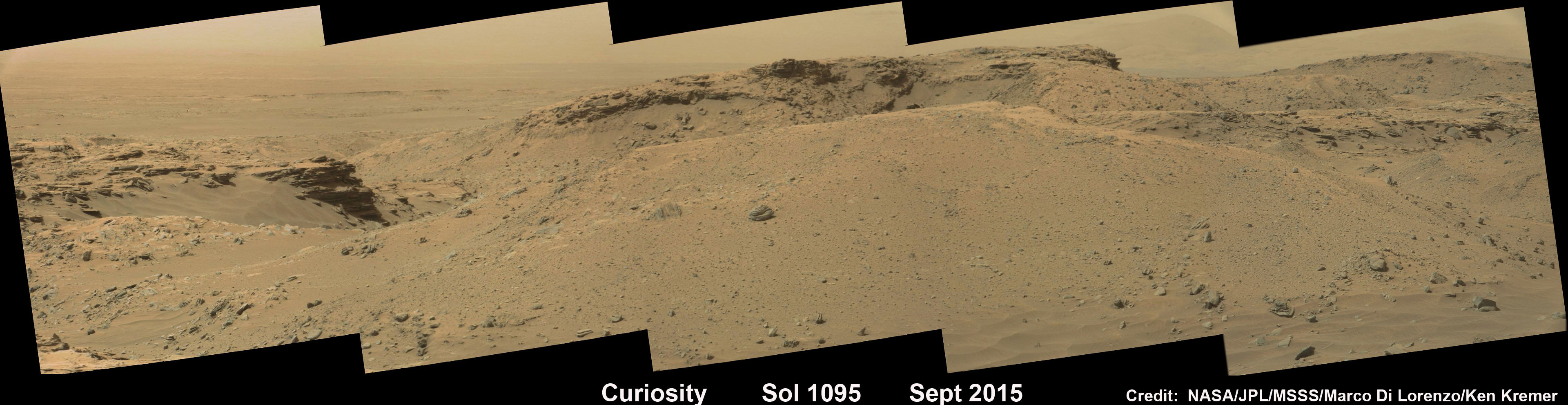
Curiosity rover explores around the Stimson unit at the base of Mount Sharp on Mars on Sol 1095, Sept. 5, 2015 in this photo mosaic stitched from Mastcam color camera raw images. Credit: NASA/JPL/MSSS/Marco Di Lorenzo/Ken Kremer/kenkremer.com
Why explore outcrops at Stimson?
“The Stimson unit overlies a layer of mudstone that was deposited in a lake environment. Curiosity has been examining successively higher and younger layers of Mount Sharp, starting with the mudstone at the mountain’s base, for evidence about changes in the area’s ancient environment.”
Curiosity’s prior drill campaign was recently conducted at the “Buckskin” outcrop target in early August 2015. Buckskin was very notable for being the first high silica rock drilling target of the mission.
Curiosity extends robotic arm and conducts sample drilling at “Buckskin” rock target at bright toned “Lion” outcrop at the base of Mount Sharp on Mars, seen at right. Gale Crater eroded rim seen in the distant background at left, in this composite multisol mosaic of navcam raw images taken to Sol 1059, July 30, 2015. Navcam camera raw images stitched and colorized. Inset: MAHLI color camera up close image of full depth drill hole at “Buckskin” rock target on Sol 1060. Credit: NASA/JPL-Caltech/MSSS/Ken Kremer/kenkremer.com/Marco Di Lorenzo
Stimson and Buckskin sit at the base of Mount Sharp, a huge layered mountain that dominates the center of the 96 mile-wide (154 kilometers-wide) Gale Crater landing site.
Exploring the sedimentary layers of Mount Sharp, which towers 3.4 miles (5.5 kilometers) into the Martian sky, is the primary destination and goal of the rovers long term scientific expedition on the Red Planet.
As of today, Sol 1102, September 12, 2015, she has driven some 6.9 miles (11.1 kilometers) kilometers and taken over 268,000 amazing images.
Curiosity has already accomplished her primary objective of discovering a habitable zone on the Red Planet – at the Yellowknife Bay area – that contains the minerals necessary to support microbial life in the ancient past when Mars was far wetter and warmer billions of years ago.
Curiosity rover scans toward south east around Marias Pass area at the base of Mount Sharp on Mars on Sol 1074, Aug. 14, 2015 in this photo mosaic stitched from Mastcam color camera raw images. Credit: NASA/JPL/MSSS/Marco Di Lorenzo/Ken Kremer/kenkremer.com
Stay tuned here for Ken’s continuing Earth and planetary science and human spaceflight news.
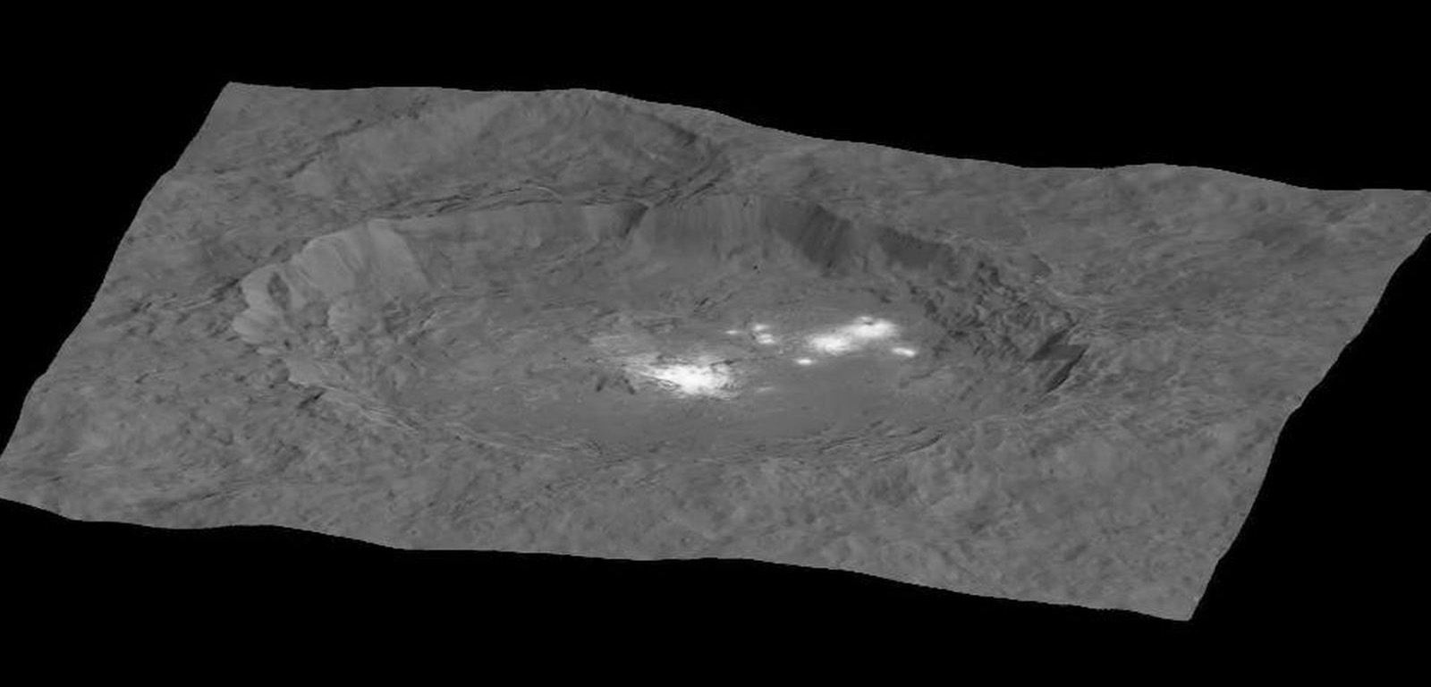
This image, made using images taken by NASA's Dawn spacecraft during the mission's High Altitude Mapping Orbit (HAMO) phase, shows Occator crater on Ceres, home to a collection of intriguing bright spots. Credits: NASA/JPL-Caltech/UCLA/MPS/DLR/IDA
This image, made using images taken by NASA’s Dawn spacecraft during the mission’s High Altitude Mapping Orbit (HAMO) phase, shows Occator crater on Ceres, home to a collection of intriguing bright spots. Credits: NASA/JPL-Caltech/UCLA/MPS/DLR/IDA
Story/imagery updated[/caption]
Since scientists believe that Ceres occupies a “unique niche” in the solar system and apparently harbors subsurface ice or liquid oceans, could the bright spots arise from subsurface “water leakage?” To find out Universe Today asked Dawn’s Principal Investigator and Chief Engineer.
“The big picture that is emerging is that Ceres fills a unique niche,” Prof. Chris Russell, Dawn principal investigator told Universe Today exclusively.
“Ceres fills a unique niche between the cold icy bodies of the outer solar system, with their rock hard icy surfaces, and the water planets Mars and Earth that can support ice and water on their surfaces,” said Russell, of the University of California, Los Angeles.
And with Dawn recently arrived at its second lowest science mapping orbit of the planned mission around icy dwarf planet Ceres in mid-August, the NASA spacecraft is capturing the most stunningly detailed images yet of those ever intriguing bright spots located inside Occator crater.
The imagery and other science data may point to evaporation of salty water as the source of the bright spots.
“Occasional water leakage on to the surface could leave salt there as the water would sublime,” Russell told me.
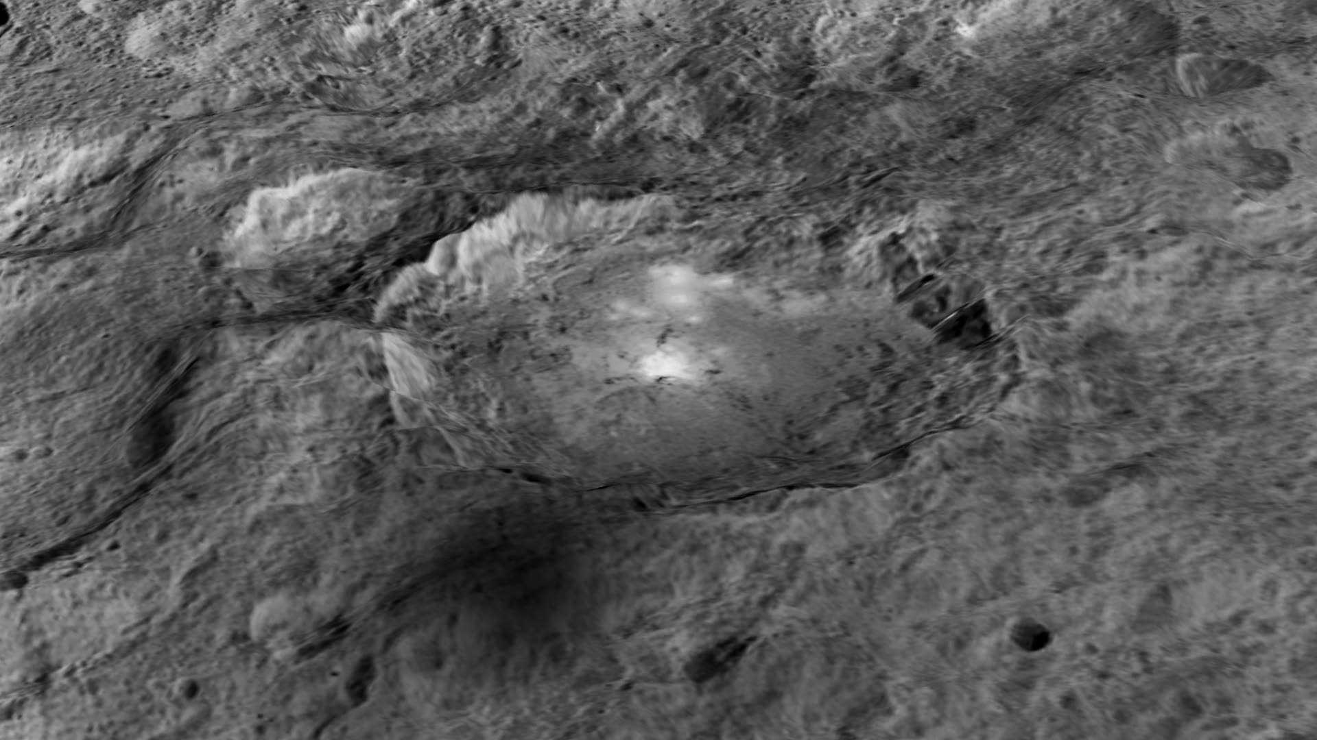
Circling the Lights of Occator crater on Ceres. This image, made using images taken by NASA’s Dawn spacecraft during the mission’s High Altitude Mapping Orbit (HAMO) phase and draped over a shape model, shows Occator crater on Ceres, home to a collection of intriguing bright spots. The image has been stretched by 1.5 times in the vertical direction to better illustrate the crater’s topography. Credits: NASA/JPL-Caltech/UCLA/MPS/DLR/IDA
Dawn is Earth’s first probe to explore any dwarf planet and the first to explore Ceres up close. It was built by Orbital ATK.
To shed more light on what still remains rather mysterious even today, NASA has just released the best yet imagery, which was taken at Dawn’s High Altitude Mapping Orbit (HAMO) phase and they raise as many questions as they answer.
Occator has captured popular fascination world-wide because the 60 miles (90 kilometers) diameter crater is rife with the alien bodies brightest spots and whose nature remains elusive to this day, over half a year after Dawn arrived in orbit this past spring on March 6, 2015.
The new imagery from Dawn’s current HAMO mapping orbit was taken at an altitude of just 915 miles (1,470 kilometers). They provide about three times better resolution than the images captured from its previous orbit in June, and nearly 10 times better than in the spacecraft’s initial orbit at Ceres in April and May, says the team.
So with the new HAMO orbit images in hand, I asked the team what’s the latest thinking on the bright spots nature?
Initially a lot of speculation focused on water ice. But the scientists opinions have changed substantially as the data pours in from the lower orbits and forced new thinking on alternative hypotheses – to the absolute delight of the entire team!
“When the spots appeared at first to have an albedo approaching 100%, we were forced to think about the possibility of [water] ice being on the surface,” Russell explained.
“However the survey data revealed that the bright spots were only reflecting about 50% of the incoming light.”
“We did not like the ice hypothesis because ice sublimes under the conditions on Ceres surface. So we were quite relieved by the lower albedo.”
“So what could be 50% reflective? If we look at Earth we find that when water evaporates on the desert it leaves salt which is reflective. We know from its density that water or ice is inside Ceres.”
“So the occasional water leakage on to the surface could leave salt there as the water would sublime even faster than ice.”
At this time no one knows how deep the potential ice deposit or water reservoir sources of the “water leakage” reside beneath the surface, or whether the bright salt spots arose from past or current activity and perhaps get replenished or enlarged over time. To date there is no evidence showing plumes currently erupting from the Cerean surface.
Video Caption: Circling Occator Crater on Ceres. This animation, made using data from NASA’s Dawn spacecraft, shows the topography of Occator crater on Ceres. Credits: Credit: NASA/JPL-Caltech/UCLA/MPS/DLR/IDA/PSI
Dawn is an international science mission and equipped with a trio of state of the art science instruments from Germany, Italy and the US. They will elucidate the overall elemental and chemical composition and nature of Ceres, its bright spots and other wondrous geological features like the pyramidal mountain object.
I asked the PI and Chief Engineer to explain specifically how and which of the instruments is the team using right now at HAMO to determine the bright spots composition?
“The instruments that will reveal the composition of the spots are the framing camera [from Germany], the infrared spectrometer, and the visible spectrometer [both from the VIR instrument from Italy], replied Dr. Marc Rayman, Dawn’s chief engineer and mission director based at NASA’s Jet Propulsion Laboratory, Pasadena, California.
“Dawn arrived in this third mapping orbit [HAMO] on Aug. 13. It began this third mapping phase on schedule on Aug. 17.”
But much work remains to gather and interpret the data and discern the identity of which salts are actually present on Ceres.
“While salts of various sorts have the right reflectance, they are hard to distinguish from one another in the visible,” Russell elaborated to Universe Today.
“That is one reason VIR is working extra hard on the IR spectrum. Scientists are beginning to speculate on the salts. And to think about what salts could be formed in the interior.”
“That is at an early stage right now,” Russell stated.
“I know of nothing exactly like these spots anywhere. We are excited about these scientific surprises!”
Occator crater lies in Ceres northern hemisphere.
“There are other lines of investigation besides direct compositional measurement that will provide insight into the spots, including the geological context,” Rayman told Universe Today.
Each of Dawn’s two framing cameras is also outfitted with a wheel of 7 color filters, explained Joe Makowski, Dawn program manager from Orbital ATK, in an interview.
Different spectral data is gathered using the different filters which can be varied during each orbit.
“So far Dawn has completed 2 mapping orbit cycles of the 6 cycles planned at HAMO.”
Each HAMO mapping orbit cycle lasts 11 days and consists of 14 orbits lasting 19 hours each. Ceres is entirely mapped during each of the 6 cycles. The third mapping cycle just started on Wednesday, Sept. 9.
The instruments will be aimed at slightly different angle in each mapping cycle allowing the team to generate stereo views and construct 3-D maps.
“The emphasis during HAMO is to get good stereo data on the elevations of the surface topography and to get good high resolution clear and color data with the framing camera,” Russell explained.
“We are hoping to get lots of VIR IR data to help understand the composition of the surface better.”
“Dawn will use the color filters in its framing camera to record the sights in visible and infrared wavelengths,” notes Rayman.
“Dawn remains at HAMO until October 23. Then it begins thrusting with the ion propulsion thrusters to reach its lowest mapping orbit named LAMO [Low Altitude Mapping Orbit],” Makowski told me.
“Dawn will arrive at LAMO on December 15, 2015.”
That’s a Christmas present we can all look forward to with glee!
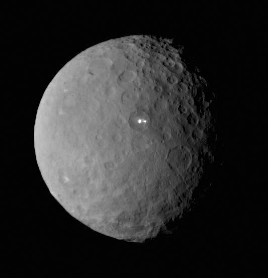
This image was taken by NASA’s Dawn spacecraft of dwarf planet Ceres on Feb. 19 from a distance of nearly 29,000 miles (46,000 kilometers). It shows that the brightest spot on Ceres has a dimmer companion, which apparently lies in the same basin. Image Credit: NASA/JPL-Caltech/UCLA/MPS/DLR/IDA
What is the teams reaction, interplay and interpretation regarding the mountains of new data being received from Dawn? How do the geologic processes compare to Earth?
“Dawn has transformed what was so recently a few bright dots into a complex and beautiful, gleaming landscape,” says Rayman. “Soon, the scientific analysis will reveal the geological and chemical nature of this mysterious and mesmerizing extraterrestrial scenery.”
“We do believe we see geologic processes analogous to those on Earth – but with important Cerean twists,” Russell told me.
“However we are at a point in the mission where conservative scientists are interpreting what we see in terms of familiar processes. And the free thinkers are imagining wild scenarios for what they see.”
“The next few weeks (months?) will be a time where the team argues amongst themselves and finds the proper compromise between tradition and innovation,” Russell concluded elegantly.
Among the highest features seen on Ceres so far is a mountain about 4 miles (6 kilometers) high, which is roughly the elevation of Mount McKinley in Alaska’s Denali National Park. Vertical relief has been exaggerated by a factor of five to help understand the topography. Credits: NASA/JPL-Caltech/UCLA/MPS/DLR/IDA/LPI
A batch of new results from Dawn at Ceres are expected to be released during science presentations at the European Planetary Science Congress 2015 being held in Nantes, France from 27 September to 2 October 2015.
The Dawn mission is expected to last until at least March 2016, and possibly longer, depending upon fuel reserves.
“It will end some time between March and December,” Rayman told me.
The science objectives in the LAMO orbit could be achieved as soon as March. But the team wants to extend operations as long as possible, perhaps to June or beyond, if the spacecraft remains healthy and has sufficient hydrazine maneuvering fuel and NASA funding to operate.
“We expect Dawn to complete the mission objectives at Ceres by March 2016. June is a the programmatic milestone for end of the nominal mission, effectively a time margin,” Makowski told Universe Today.
“The team is working to a well-defined exploration plan for Ceres, which we expect to accomplish by March, if all goes well.”
“At launch Dawn started with 45 kg of hydrazine. It has about 21 kg of usable hydrazine onboard as of today.”
“We expect to use about 15 kg during the nominal remaining mission,” Makowski stated.
Therefore Dawn may have roughly 5 kg or so of hydrazine fuel for any extended mission, if all goes well, that may eventually be approved by NASA. Of course NASA’s budget depends also on what is approved by the US Congress.
The intriguing brightest spots on Ceres lie in a crater named Occator, which is about 60 miles (90 kilometers) across and 2 miles (4 kilometers) deep. Vertical relief has been exaggerated by a factor of five. Exaggerating the relief helps scientists understand and visualize the topography much more easily, and highlights features that are sometimes subtle. Credits: NASA/JPL-Caltech/UCLA/MPS/DLR/IDA/LPI
Dawn was launched on September 27, 2007 by a United Launch Alliance (ULA) Delta II Heavy rocket from Space Launch Complex-17B (SLC-17B) at Cape Canaveral Air Force Station, Florida.
Stay tuned here for Ken’s continuing Earth and planetary science and human spaceflight news.
Dawn launch on September 27, 2007 by a United Launch Alliance Delta II Heavy rocket from Cape Canaveral Air Force Station, Florida. Credit: Ken Kremer/kenkremer.com
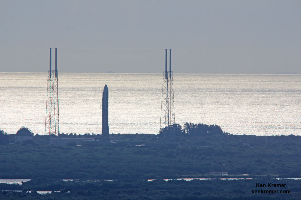
MUOS-4 US Navy communications satellite and Atlas V rocket at pad 41 at Cape Canaveral Air Force Station, FL for launch on Sept. 2, 2015 at 5:59 a.m. EDT. Credit: Ken Kremer/kenkremer.com
America’s premier rocket launch services providerUnited Launch Alliance, or ULA, may be up for sale according to media reports, including Reuters and the Wall Street Journal. Any such sale would result in a major shakeup of the American rocket launching business with far reaching implications.
Aerojet-Rocketdyne has apparently made a bid to buy ULA for approximately $2 Billion in cash, based on behind the scenes information gathered from unnamed sources.
ULA was formed in 2006 as a 50:50 joint venture between aerospace giants Lockheed Martin and Boeing that combined their existing expendable rocket fleet families – the Atlas V and Delta IV – under one roof.
According to Reuters, Aerojet Rocketdyne recently proffered a $2 billion cash offer to buy ULA from Lockheed Martin and Boeing.
“Aerojet Rocketdyne board member Warren Lichtenstein, the chairman and chief executive of Steel Partners LLC, approached ULA President Tory Bruno and senior Lockheed and Boeing executives about the bid in early August,” sources told Reuters.
ULA’s Bruno declined to comment on the story via twitter.
“Wish I could, but as a matter of policy, we don’t comment on this type of story,” Bruno tweeted in response to inquiries.
Since 2006 ULA has enjoyed phenomenal launch success with its venerable fleet of Atlas V and Delta IV rockets and also enjoyed a virtual launch monopoly with the US Government and for the nations most critical national security military payloads.
And just last week, ULA conducted its 99th launch with the successful blastoff of an Atlas V with the MUOS-4 military communications satellite from Cape Canaveral Air Force Station for the U.S. Navy.
A United Launch Alliance (ULA) Delta IV rocket carrying the WGS-7 mission for the U.S. Air Force launches from Cape Canaveral Air Force Station, Fl, on July 23, 2015. Credit: Ken Kremer/kenkremer.com
Furthermore a Congressional ban on importing the Russian-made RD-180 first stage engines that power the Atlas V rocket, that takes effect in a few years, has threatened the rockets future viability. The Atlas V dependence on Russia’s RD-180’s landed at the center of controversy after Russia invaded Crimea in the spring of 2014.
To date the Atlas V enjoys a 100 percent success rate after over 50 launches.
In response to the Congressional RD-180 engine ban and relentless cost pressures from SpaceX, ULA CEO Tory Bruno and ULA Vice President for Advanced Concepts and Technology George Sowers announced ULA will develop a cost effective new rocket named Vulcan using American made engines.
“To be successful and survive ULA needs to transform to be more of a competitive company in a competitive environment,” Dr. Sowers told Universe Today in a wide ranging interview regarding the rationale and goals of the Vulcan rocket.
Vulcan is ULA’s next generation rocket to space and slated for an inaugural liftoff in 2019.
Vulcan – United Launch Alliance (ULA) next generation rocket is set to make its debut flight in 2019. Credit: ULA
However, Lockheed Martin and Boeing are only providing funds to ULA on a quarterly basis to continue development of the Vulcan.
Vulcan’s first stage will most likely be powered by the BE-4 engine being developed by the secretive Blue Origin aerospace firm owned by billionaire Jeff Bezos.
Interestingly, ULA is also evaluating the AR-1 liquid fueled engine being developed by Aerojet-Rocketdyne.
The final decision on which engine to use is expected sometime in 2016.
The engine choice could clearly be impacted if Aerojet-Rocketdyne buys ULA.
Aerojet-Rocketdyne has also sought to buy the rights to manufacture the Atlas V from ULA, which is currently planned to be retired several years after Vulcan is introduced.
To this writer, ULA would seem to be worth far more than $2 Billion. They own manufacturing and rocket launch facilities on both coasts and in several states.
Stay tuned here for Ken’s continuing Earth and planetary science and human spaceflight news.
The International Space Station transits the sun on Sunday, Sept. 6, 2015 with an enhanced crew of nine, as seen from Shenandoah National Park, Front Royal, VA in this composite image by NASA photographer Bill Ingalls. Credit: NASA/Bill Ingalls
The International Space Station transits the sun on Sunday, Sept. 6, 2015 with an enhanced crew of nine, as seen from Shenandoah National Park, Front Royal, VA in this composite image by NASA photographer Bill Ingalls. Credit: NASA/Bill Ingalls
Story/photos updated[/caption]
A spectacular new image taken from Earth showcases the International Space Station (ISS) transiting our Sun this past weekend, as the orbiting outpost is temporarily home to an enlarged crew of nine persons hailing from five nations.
The beautiful composite view of the ISS transiting the sun is shown above. It was released by NASA today, Sept. 8, and was created by combining a rapid fire series of five images taken on Sunday, Sept. 6, 2015 from Shenandoah National Park, Front Royal, VA, by renowned NASA photographer Bill Ingalls.
Ingalls is NASA’s top photographer for numerous space launches and NASA events worldwide.
Exquisitely careful planning is required to capture events such as this solar transit which is over in barely the wink of an eye.
The ISS was hurtling along at about 5 miles per second which has a rarely beef up complement of nine humans serving aboard for a short period of barely a week time.
The cosmonauts and astronaut crew currently aboard comprises two Americans, four Russians, and one each from Japan, Denmark and Kazakhstan; namely NASA astronauts Scott Kelly and Kjell Lindgren: Russian Cosmonauts Gennady Padalka, Mikhail Kornienko, Oleg Kononenko, Sergey Volkov, Japanese astronaut Kimiya Yui, Danish Astronaut Andreas Mogensen, and Kazakhstan Cosmonaut Aidyn Aimbetov.
The nine-member space station crew takes questions from journalists around the world on Sept. 8, 2015. Credit: NASA TV
They arrived aboard three different Russian Soyuz capsules.
They arrived at the ISS in March and are now about half way through their nearly 12 month stay aimed at conducting research to explore the impact of long term stays in space on the human body and aid NASA’s long term plans for a human ‘Journey to Mars’ in the 2030s.
Kelly assumed command of the ISS on Saturday when it was formally handed over in a ceremony by Cosmonaut Gennady Padalka – who will soon depart for the voyage back home after completing his six month stint.
This marks Kelly’s second time serving as ISS commander. He was also a NASA Space Shuttle commander.
Mogensen and Aimbetov are first time space flyers and part of a short term 10 day taxi mission.
Along with Soyuz commander Sergey Volkov of Roscosmos, they launched to the ISS aboard the Soyuz TMA-18M from the Baikonur Cosmodrome in Kazakhstan this past Wednesday, Sept. 2, 2015 and docked two days later on Friday, Sept. 4.
Mogensen and Aimbetov will undock from the station on Friday, Sept. 11 along with Cosmonaut Gennady Padalka as Soyuz commander, the human with the distinction of the most time in space. Altogether Padalka will have accumulated 879 days in space over five missions, four on the space station and one on Russia’s Mir.
Sergey Volkov of Roscosmos, Andreas Mogensen of ESA (European Space Agency) and Aidyn Aimbetov of the Kazakh Space Agency launched aboard Soyuz TMA-18M from the Baikonur Cosmodrome in Kazakhstan at 12:37 a.m. EDT on Wednesday (10:37 a.m. in Baikonur). Credits: NASA TV
Since the forced retirement of NASA’s shuttle orbiters in 2011, US astronauts have been totally dependent on the Russians for trips to space and back.
Boeing and SpaceX are now building America’s next human spaceships under contracts awarded by NASA.
‘Starliner’ is the new name of Boeing’s CST-100 commercial crew transportation spaceship – as announced during the Grand Opening event for the craft’s manufacturing facility held at the Kennedy Space Center on Friday, Sept 4. 2015 and attended by Universe Today. Read my story – here.
Stay tuned here for Ken’s continuing Earth and planetary science and human spaceflight news.
First view of the Boeing CST-100 'Starliner' crewed space taxi at the Sept. 4, 2015 Grand Opening ceremony held in the totally refurbished C3PF manufacturing facility at NASA's Kennedy Space Center. These are the upper and lower segments of the first Starliner crew module known as the Structural Test Article (STA) being built at Boeing’s Commercial Crew and Cargo Processing Facility (C3PF) at KSC. Credit: Ken Kremer /kenkremer.com
First view of the Boeing CST-100 ‘Starliner’ crewed space taxi at the Sept. 4, 2015 Grand Opening ceremony held in the totally refurbished C3PF manufacturing facility at NASA’s Kennedy Space Center. These are the upper and lower segments of the first Starliner crew module known as the Structural Test Article (STA) being built at Boeing’s Commercial Crew and Cargo Processing Facility (C3PF) at KSC. Credit: Ken Kremer /kenkremer.com
Story/photos updated[/caption]
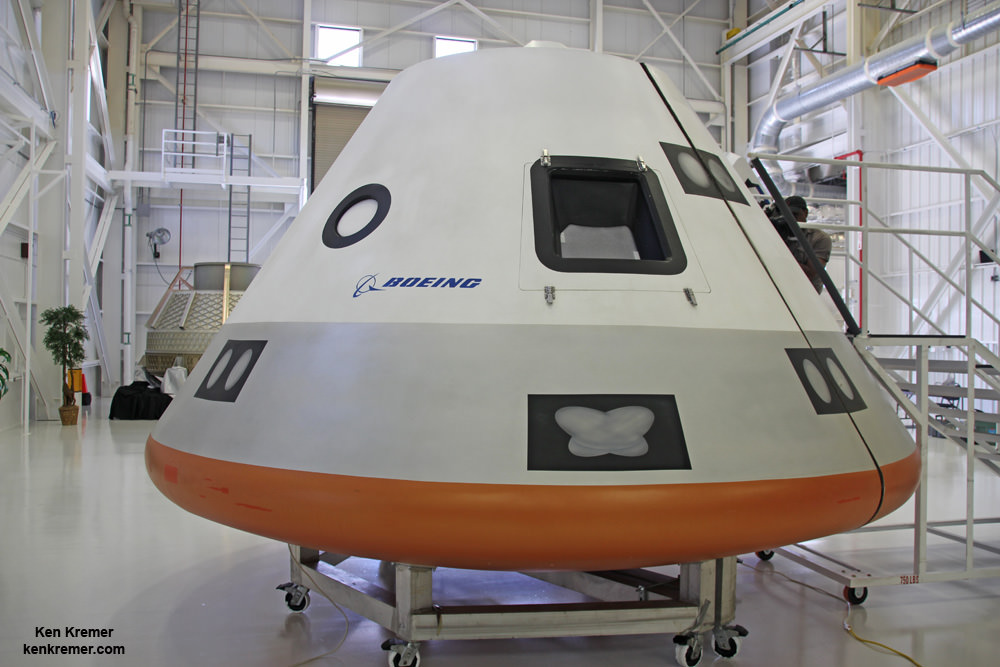
KENNEDY SPACE CENTER, FL – ‘Starliner’ is the new name of America’s next spaceship destined to launch our astronauts to orbit. The new commercial craft from Boeing will restore America’s capability to launch American astronauts from American soil to the International Space Station (ISS) in 2017 – and the magnificent looking first capsule is already taking shape!
Built by The Boeing Company, ‘Starliner’ was officially announced by Boeing and NASA as the new name of the company’s CST-100 commercial crew transportation spacecraft during the Grand Opening event for the craft’s manufacturing facility held at the Kennedy Space Center on Friday, Sept 4. 2015 and attended by Universe Today.
‘Starliner’ counts as history’s first privately developed ‘Space Taxi’ to carry humans to space – along with the Crew Dragon being simultaneously developed by SpaceX.
“Please welcome the CST-100 Starliner,” announced Chris Ferguson, the former shuttle commander who now is deputy manager of operations for Boeing’s Commercial Crew Program, at the Grand Opening event hosting numerous dignitaries.
The CST-100 ‘Starliner’ is at the forefront of ushering in the new commercial era of space flight and will completely revolutionize how we access, explore and exploit space for the benefit of all mankind.
Starliner will be mostly automated for ease of operation and is capable of transporting astronaut crews of four or more to low Earth orbit and the ISS as soon as mid 2017 if all goes well and Congress approves the required funding.
“One hundred years ago we were on the dawn of the commercial aviation era and today, with the help of NASA, we’re on the dawn of a new commercial space era,” said Boeing’s John Elbon, vice president and general manager of Space Exploration.
“It’s been such a pleasure to work hand-in-hand with NASA on this commercial crew development, and when we look back 100 years from this point, I’m really excited about what we will have discovered.”
Boeing ‘Starliner’ commercial crew space taxi manufacturing facility marks Grand Opening at the Kennedy Space Center on Sept 4. 2015. Exterior view depicting newly installed mural for the Boeing Company’s newly named CST-100 ‘Starliner’ commercial crew transportation spacecraft on the company’s Commercial Crew and Cargo Processing Facility (C3PF) at NASA’s Kennedy Space Center in Florida. Credit: Ken Kremer /kenkremer.com
The CST-100 ‘Starliner’ will be produced in Boeing’s newly revamped manufacturing facility dubbed the Commercial Crew and Cargo Processing Facility (C3PF) on site at the Kennedy Space Center in Florida.
The CC3P building was previously known as Orbiter Processing Facility-2 (OPF-3) and utilized by NASA to process the agency’s space shuttle orbiters between crewed flights during the three decade long Space Shuttle program.
“When Boeing was looking for the prime location for its program headquarters, we knew Florida had a lot to offer from the infrastructure to the supplier base to the skilled work force,” said Chris Ferguson.
“Starliner will launch on an Atlas V from pad 41 at Cape Canaveral Air Force Station in Florida. It has the capability to dock at the ISS within 24 hours. It can stay docked at the station for 6 months.”
Over the past few years, the historic facility has been completely renovated, upgraded and transformed into a state of the art manufacturing site for Boeing’s commercial CST-100 Starliner.
First view of upper half of the Boeing CST-100 ‘Starliner’ crewed space taxi unveiled at the Sept. 4, 2015 Grand Opening ceremony held in the totally refurbished C3PF manufacturing facility at NASA’s Kennedy Space Center. This will be part of the first Starliner crew module known as the Structural Test Article (STA) being built at Boeing’s Commercial Crew and Cargo Processing Facility (C3PF) at KSC. Credit: Ken Kremer /kenkremer.com
It is also a key part of NASA’s overarching strategy to send Humans on a “Journey to Mars” in the 2030s.
“Commercial crew is an essential component of our journey to Mars, and in 35 states, 350 American companies are working to make it possible for the greatest country on Earth to once again launch our own astronauts into space,” said NASA Administrator Charles Bolden. “That’s some impressive investment.”
Crew access tunnel and hatch for Boeing CST-100 Starliner that attaches to upper dome of the crew module for the Structural Test Article being manufactured at the company’s Commercial Crew and Cargo Processing Facility (C3PF) at NASA’s Kennedy Space Center in Florida. Credit: Ken Kremer /kenkremer.com
The commercial crew program is designed to return human spaceflight launches to the United States and end our sole source reliance on Russia and the Soyuz capsule for all manned flights to the ISS and crew rotation missions.
Since the forced retirement of NASA’s shuttle orbiters in 2011, US astronauts have been totally dependent on the Russians for trips to space and back.
SpaceX also received a NASA award worth $2.6 Billion to build the Crew Dragon spacecraft for launch atop the firms man-rated Falcon 9 rocket.
Final assembly of both half’s of Starliner will take place in the C3PF – namely the crew command module and the service module.
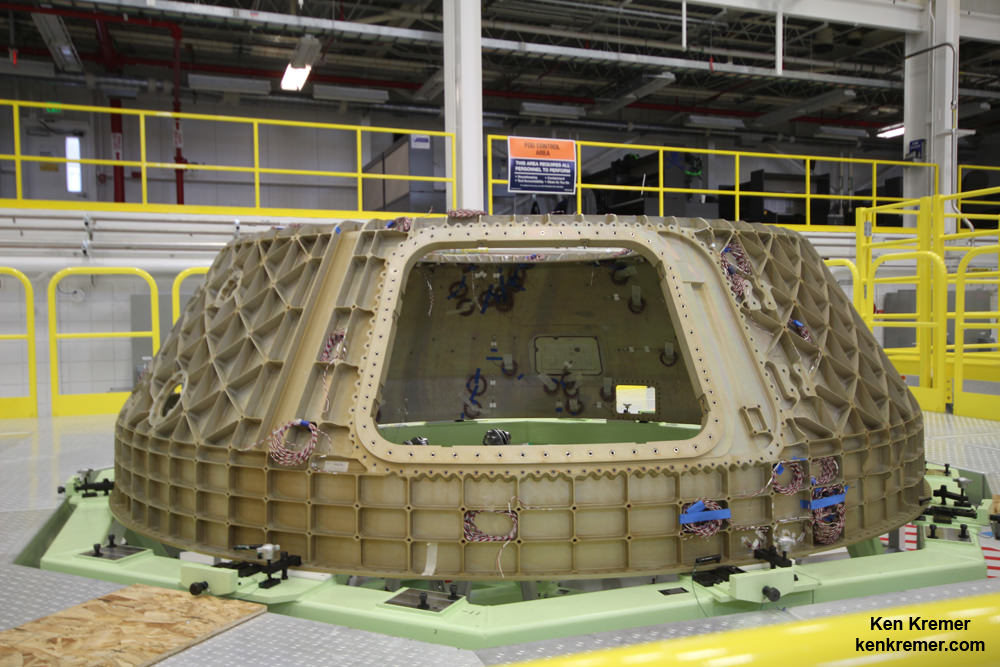
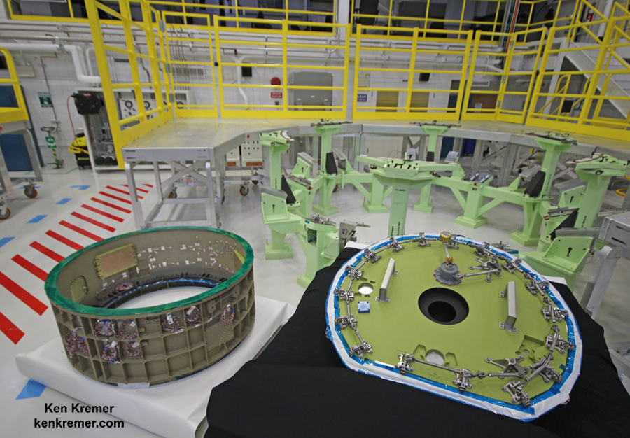
Boeing is already building the first version of Starliner known as the Structural Test Article (STA) . The STA will be used for extensive prelaunch testing and evaluation to ensure it will be ready and robust and capable of safely launches humans to orbit on a very cost effective basis.
The Starliner STA is rapidly taking shape. The first components have been built and were on display at the C3PF Grand Opening eventy of Sept. 4. They are comprised of the upper and lower halves of the crew command module, the crew access tunnel and adapter.
The shell of Starliner’s first service module was also on display.
“The STA will be completed in early 2016,” said John Mulholland Boeing Vice President, Commercial Programs, at the event.
“Then we start assembly of the Qualification Test Article.”
I asked Mulholland to describe the currently planned sequence of Starliner’s initial uncrewed and crewed flights.
“The first uncrewed flight is expected to occur in May 2017. Then comes the Pad Abort Test in August 2017. The first crewed flight is set for September 2017. The first contracted regular service flight (PCM-1) is set for December 2017,” Mulholland told me.
“It’s all very exciting.”
Boeing CST-100 crew capsule will carry five person crews to the ISS. Credit: Ken Kremer – kenkremer.com
“Kennedy Space Center has transitioned more than 50 facilities for commercial use. We have made improvements and upgrades to well-known Kennedy workhorses such as the Vehicle Assembly Building, mobile launcher, crawler–transporter and Launch Pad 39B in support of Orion, the SLS and Advanced Exploration Systems,” said Robert Cabana, Kennedy’s center director.
“I am proud of our success in transforming Kennedy Space Center to a 21st century, multi-user spaceport that is now capable of supporting the launch of all sizes and classes of vehicles, including horizontal launches from the Shuttle Landing Facility, and spacecraft processing and landing.”
Boeing and NASA managers pose with the Boeing CST-100 Starliner crew module being assembled into the Structural Test Article at company’s C3PF facility at the Kennedy Space Center in Florida. From left are John Mulholland, Boeing Vice President Commercial Programs; Chris Ferguson, former shuttle commander now Boeing deputy manager Commercial Crew Program; John Elbon, Boeing vice president and general manager of Space Exploration; and Robert Cabana, former shuttle commander and now Director NASA’s Kennedy Space Center, on Sept. 4, 2015. Credit: Ken Kremer/kenkremer.com
Read my earlier exclusive, in depth one-on-one interviews with Chris Ferguson – America’s last shuttle commander and who now leads Boeings CST-100 program; here and here.
Stay tuned here for Ken’s continuing Earth and planetary science and human spaceflight news.
Boeing’s commercial CST-100 ‘Space Taxi’ will carry a crew of five astronauts to low Earth orbit and the ISS from US soil. Mockup with astronaut mannequins seated below pilot console and Samsung tablets was unveiled on June 9, 2014 at its planned manufacturing facility at the Kennedy Space Center in Florida. Credit: Ken Kremer – kenkremer.com
ULA Atlas V rocket successfully launches MUOS-4 for the U.S. Navy on Sept. 2, 2015 from Cape Canaveral Air Force Station, Florida. Credit: ULA
ULA Atlas V rocket successfully launches MUOS-4 for the U.S. Navy on Sept. 2, 2015 from Cape Canaveral Air Force Station, Florida. Credit: ULA
See launch gallery below[/caption]
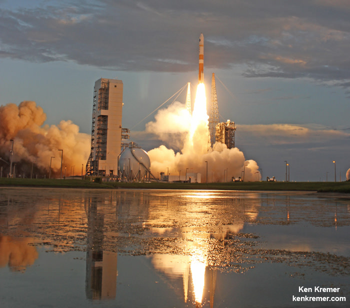
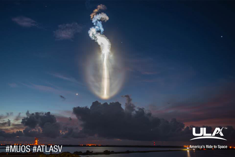
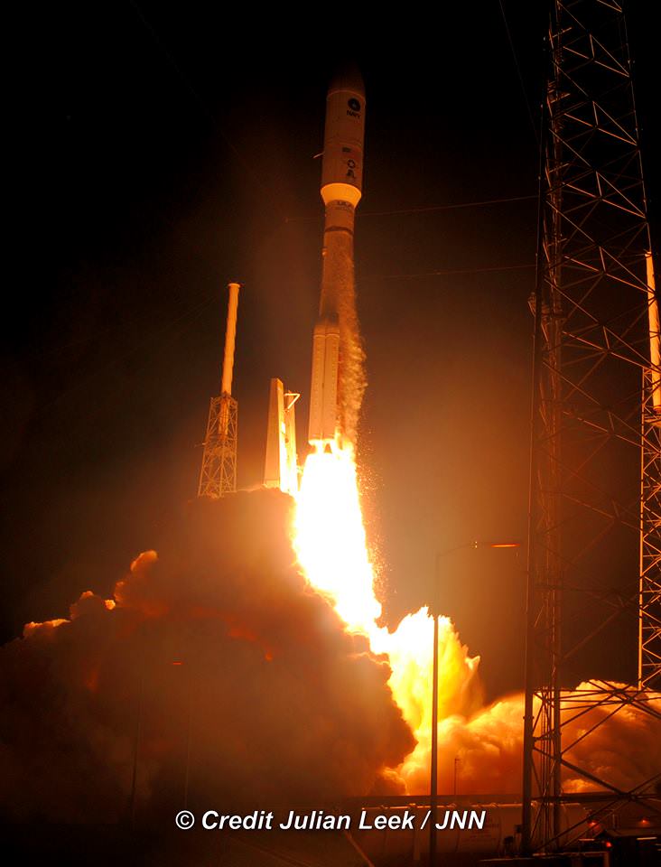
CAPE CANAVERAL AIR FORCE STATION, FL – Today’s (Sept. 2) stunningly successful launch of the US Navy’s revolutionary MUOS-4 tactical communications satellite atop a mighty Atlas V rocket produced an unexpectedly exotic skyshow beyond compare for lucky spectators all around the Florida Space Coast, as it thundered off a Cape Canaveral launch pad and simultaneously generated house and bone rattling vibrations.
Seasoned and long time launch enthusiasts have rarely if ever never seen anything like this morning’s spectacular predawn launch of the Mobile User Objective System-4 (MUOS-4) satellite for the US Navy at 6:18 a.m. EDT aboard a United Launch Alliance Atlas V rocket from Cape Canaveral Air Force Station, Florida.
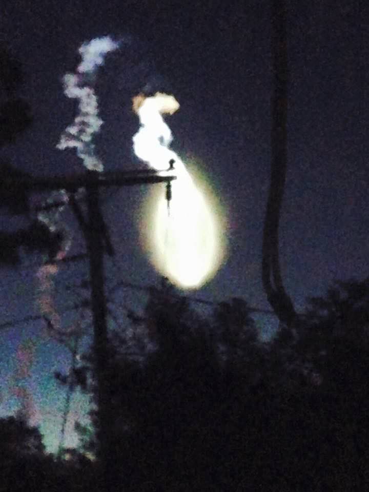
As the rocket arced over eastwards above the Atlantic Ocean the huge vapor trail turned utterly exotic – producing a whitish oval glow that appeared out of nowhere, and looked to me like a moving and living creature as it moved downwards and forwards. Although the rocket appeared to head towards the Earth’s horizon it was actually being propelled to orbit by the most powerful variant of the Atlas V rocket.
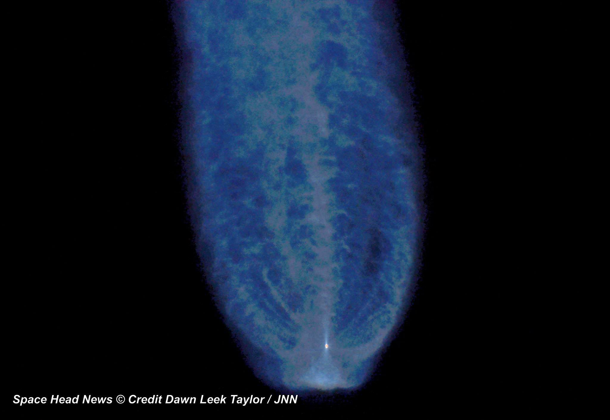
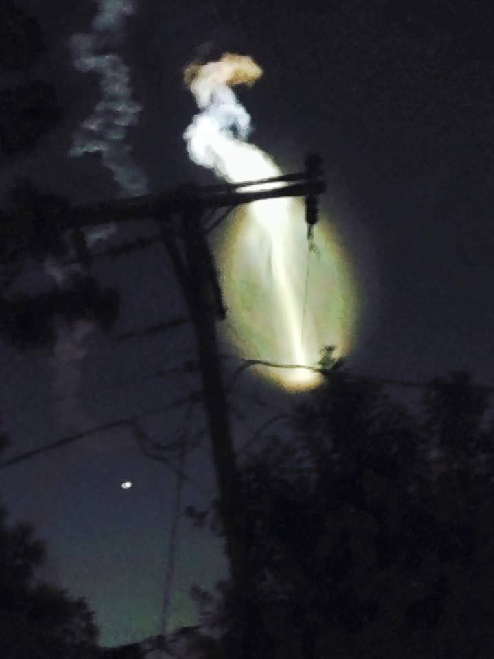
Exotic vapor trail produced by launch of MUOS-4 communications satellite for the US Navy atop a United Launch Alliance Atlas V rocket from Space launch Complex-41 at Cape Canaveral Air Force Station, FL on Sept. 2, 2015. Credit: Dawn Leek Taylor/Space Head News
The alien looking trail was fortuitously highlighted by glint from the sun that may have been enhanced by a slight delay of some 19 minutes from the originally planned launch time of 5:59 a.m. EDT as the launch team worked to resolve a technical issue.
Local residents in the Titusville, Fl, area and surroundings told me that their houses and windows shook this morning from the powerful roar and thunderous sound waves pulsing away from the Atlas V rocket. Sleeping children were awoken, close to school time anyway! And another gentleman said he felt it inside the shower with running water – having misunderstood the launch time!
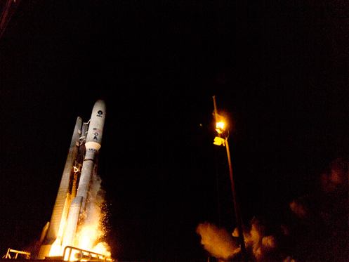
Blastoff of MUOS-4 US Navy communications satellite on United Launch Alliance Atlas V rocket from pad 41 at Cape Canaveral Air Force Station, FL on Sept. 2, 2015. Credit: Ken Kremer/kenkremer.com
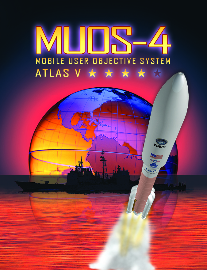
The Lockheed Martin-built MUOS-4 satellite was successfully orbited by the Atlas V and is already talking from space to the satellite control team at the Naval Spacecraft Operations Control facility in Naval Base Ventura County, Point Mugu, Calif.
MUOS-4 will enable near-global coverage for a new secure military communications network offering enhanced capabilities for mobile forces.
“Today’s successful launch will enable the MUOS constellation to reach global coverage,” said Jim Sponnick, ULA vice president, Atlas and Delta Programs.
“The Lockheed Martin-built MUOS-4 satellite will deliver voice, data, and video communications capability, similar to a cellular network, to our troops all over the globe.”
Weird exhaust trail from launch of MUOS-4 communications satellite for the US Navy atop a United Launch Alliance Atlas V rocket from Space launch Complex-41 at Cape Canaveral Air Force Station, FL on Sept. 2, 2015 by Titusville, FL resident Ashley Crouch. Credit: Ashley Crouch
MUOS is a next-generation narrowband tactical satellite communications system designed to significantly improve ground communications for U.S. forces on the move.
This is the fourth satellite in the MUOS series and will provide military users up to 16 times more communications capability over existing systems, including simultaneous voice, video and data, leveraging 3G mobile communications technology.
With MUOS-4 in orbit the system’s initial constellation is completed. It provides the MUOS network with near-global coverage. Communications coverage for military forces now extends further toward the North and South poles than ever before, according to Lockheed Martin officials.
Exotic vapor trail produced by launch of MUOS-4 communications satellite for the US Navy atop a United Launch Alliance Atlas V rocket from Space launch Complex-41 at Cape Canaveral Air Force Station, FL on Sept. 2, 2015. Credit: Ken Kremer/kenkremer.com
The unmanned Atlas V expendable rocket launched in its mightiest configuration known as the Atlas V 551 with five solid rocket boosters augmenting the first stage.
The 206 foot-tall rocket features a 5-meter diameter payload fairing, five Aerojet Rocketdyne first stage strap on solid rocket motors and a single engine Centaur upper stage powered by the Aerojet Rocketdyne RL10C-1 engine.
The first stage is powered by the Russian-built dual nozzle RD AMROSS RD-180 engine. Combined with the five solid rocket motors, the Atlas V first stage generates over 2.5 million pounds of liftoff thrust.
The RD-180 burns RP-1 (Rocket Propellant-1 or highly purified kerosene) and liquid oxygen and delivers 860,200 lb of thrust at sea level.
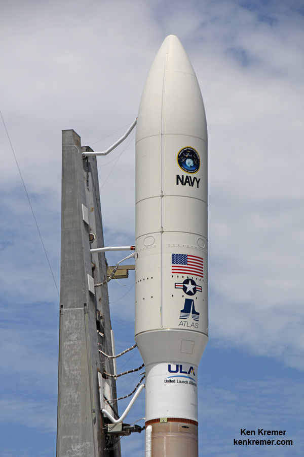
And the rocket needed all that thrust because the huge MUOS-4 was among the heftiest payloads ever lofted by an Atlas V booster, weighing in at some 15,000 pounds.
MUOS-4, the next satellite scheduled to join the U.S. Navy’s Mobile User Objective System (MUOS) secure communications network, launched on Sept 2, 2015 from Cape Canaveral Air Force Station, Florida and is responding normally to ground control. Credit: Lockheed Martin
Ken is onsite for launch coverage from Cape Canaveral Air Force Station and the Kennedy Space Center.
Stay tuned here for Ken’s continuing Earth and planetary science and human spaceflight news.
Learn more about MUOS-4 US Navy launch, Orion, SLS, SpaceX, Boeing, ULA, Space Taxis, Mars rovers, Orbital ATK, Antares, NASA missions and more at Ken’s upcoming outreach events:
Sep 2/3: “MUOS-4 launch, Orion, Commercial crew, Curiosity explores Mars, Antares and more,” Kennedy Space Center Quality Inn, Titusville, FL, evenings
Weird exhaust trail from launch of MUOS-4 communications satellite for the US Navy atop a United Launch Alliance Atlas V rocket from Space launch Complex-41 at Cape Canaveral Air Force Station, FL on Sept. 2, 2015 by Titusville, FL resident Ashley Crouch. Credit: Ashley CrouchLiftoff of MUOS-4 comsat for US Navy on a United Launch Alliance Atlas V rocket from Space launch Complex-41 at Cape Canaveral Air Force Station, FL on Sept. 2, 2015. Credit: Julian Leek/Space Head NewsMUOS-4 US Navy communications satellite and Atlas V rocket at pad 41 at Cape Canaveral Air Force Station, FL for launch on Sept. 2, 2015 at 5:59 a.m. EDT. Credit: Ken Kremer/kenkremer.com
MUOS-4 US Navy communications satellite and Atlas V rocket at pad 41 at Cape Canaveral Air Force Station, FL for launch on Sept. 2, 2015 at 5:59 a.m. EDT. Credit: Ken Kremer/kenkremer.com
CAPE CANAVERAL AIR FORCE STATION, FL – Blastoff of an advanced communications satellite for the US Navy is set for early Wednesday morning, Sept. 2, using the most powerful variant of the United Launch Alliance (ULA) Atlas V rocket – following a 48 hour postponement due to terrible weather expected from Tropical Storm Erika, which pounded islands in the Caribbean causing destruction and over 20 deaths.
The threat of strong winds and heavy rains forced Florida Gov. Rick Scott to declare a state of emergency in every county in Florida last Friday that was still in effect as rains doused central Florida on Monday.
ULA decided against rolling the Atlas V rocket out to the seaside pad on Saturday in support of the then planned launch of the Multi-User Objective System satellite on Aug. 31.
Liftoff of the Multi-User Objective System-4 (MUOS-4) satellite for the US Navy is now slated for 5:59 a.m. EDT from Space Launch Complex-41 at Cape Canaveral Air Force Station in Florida, and will be broadcast live.
The launch window extends for 44 minutes from 5:59-6:43 a.m. EDT and the weather outlook is now promising.
US Air Force weather forecasters currently predict a 70% chance of favorable weather conditions for “GO” at launch time on Wednesday morning.
The primary concern is for cumulus clouds.
The unmanned Atlas V expendable rocket will launch in its mightiest configuration known as the Atlas V 551 with five solid rocket boosters augmenting the first stage.
Therefore the predawn liftoff is expected to be absolutely spectacular, resonating with a thunderous roar rising on a huge smoke trail that will light up the darkened skies all around the Florida Space Coast for spectators here and far beyond.
You can watch the launch on your laptop or smart phone since it will be carried live on a ULA webcast: http://www.ulalaunch.com
The ULA webcast starts about 20 minutes before launch.
The launch time moves up 4 minutes in the event of a 24 hour delay. The weather prognosis stands at 70 percent “GO”.
MUOS-4 US Navy communications satellite stowed inside huge 5 meter diameter payload fairing atop Atlas V rocket at pad 41 at Cape Canaveral Air Force Station, FL set for launch on Sept. 2, 2015. EDT. Credit: Ken Kremer/kenkremer.com
MUOS is a next-generation narrowband tactical satellite communications system designed to significantly improve ground communications for U.S. forces on the move.
This is the fourth and last satellite in the MUOS series and will provide military users 10 times more communications capability over existing systems, including simultaneous voice, video and data, leveraging 3G mobile communications technology.
MUOS-4 satellite artwork. Credit: US Navy/ULA
MUOS-3 launched earlier this year.
The launch countdown will begin at 11:09 p.m. EDT on Tuesday night, Sept. 1, followed by fueling of the Atlas V rocket.
Ken is onsite for launch coverage from Cape Canaveral Air Force Station and the Kennedy Space Center.
Stay tuned here for Ken’s continuing Earth and planetary science and human spaceflight news.
United Launch Alliance Atlas V rocket with MUOS-4 US Navy communications satellite poised at pad 41 at Cape Canaveral Air Force Station, FL, set for launch on Sept. 2, 2015. EDT. View from atop NASA’s SLS mobile launcher at the Kenned Space Center. Credit: Ken Kremer/kenkremer.com
………….
Learn more about MUOS-4 US Navy launch, Orion, SLS, SpaceX, Boeing, ULA, Space Taxis, Mars rovers, Orbital ATK, Antares, NASA missions and more at Ken’s upcoming outreach events:
Sep 1 – Sep 2: “MUOS-4 launch, Orion, Commercial crew, Curiosity explores Mars, Antares and more,” Kennedy Space Center Quality Inn, Titusville, FL, evenings