Topographic elevation map of Ceres showing some newly-named craters. Credit: NASA/JPL-Caltech/UCLA/MPS/DLR/IDA.
Ceres’ topography is revealed in full (but false) color in a new map created from elevation data gathered by NASA’s Dawn spacecraft, now nearly five months in orbit around the dwarf planet orbiting the Sun within the main asteroid belt.
With craters 3.7 miles (6 km) deep and mountains rising about the same distance from its surface, Ceres bears a resemblance to some of Saturn’s frozen moons.
“The craters we find on Ceres, in terms of their depth and diameter, are very similar to what we see on Dione and Tethys, two icy satellites of Saturn that are about the same size and density as Ceres,” said Paul Schenk, Dawn science team member and a geologist at the Lunar and Planetary Institute (LPI) in Houston, TX. “The features are pretty consistent with an ice-rich crust.”
Check out a rotation video of Ceres’ topography below:
In addition to elevation mapping Ceres has also had some of its more prominent craters named. No longer just “bright spot crater” and “Spot 1,” these ancient impact scars now have official IAU monikers… from the Roman Occator to the Hawaiian Haulani to the Hopi Kerwan, craters on Ceres are named after agriculture-related gods and goddesses of mythologies from around the world.
Ceres’ famous “bright spot” crater is now named Occator, after the Roman god of harrowing. (NASA/JPL-Caltech/UCLA/MPS/DLR/IDA)
Dawn is currently moving closer toward Ceres into its third mapping orbit. By mid-August it will be 900 miles (1448 km) above Ceres’ surface and will proceed with acquiring data from this lower altitude, three times closer than it has been previously.
At 584 miles (940 km) in diameter Ceres is about 40 percent the size of Pluto.
NASA’s Dawn spacecraft is the first to successfully enter orbit around two different mission targets and the first to orbit a dwarf planet. Its first target was the asteroid Vesta, which it orbited from July 2011 to September 2012. Dawn arrived in orbit at Ceres on March 6, 2015 and there it will remain during its primary science phase and beyond; Ceres is now Dawn’s permanent home.
Ceres (left, Dawn image) compared to Tethys (right, Cassini image) at comparative scale sizes. (Credits: NASA/JPL-Caltech/UCLA/MPS/DLR/IDA and NASA/JPL-Caltech/SSI. Comparison by J. Major.)
Highest resolution mosaic of ‘Tombaugh Regio’ shows the heart-shaped region on Pluto focusing on ice flows and plains of ‘Sputnik Planum’ at top and icy mountain ranges of ‘Hillary Montes’ and ‘Norgay Montes’ below. This new mosaic combines the seven highest resolution images captured by NASA’s New Horizons LORRI imager during history making closest approach flyby on July 14, 2015. Inset at right shows global view of Pluto with location of mosaic and huge heart-shaped region in context. Annotated with place names. Credit: NASA/JHUAPL/SWRI/ Marco Di Lorenzo/Ken Kremer/kenkremer.com
Highest resolution mosaic of ‘Tombaugh Regio’ shows the heart-shaped region on Pluto focusing on ice flows and plains of ‘Sputnik Planum’ at top and icy mountain ranges of ‘Hillary Montes’ and ‘Norgay Montes’ below. This new mosaic combines the seven highest resolution images captured by NASA’s New Horizons LORRI imager during history making closest approach flyby on July 14, 2015. Inset at right shows global view of Pluto with location of mosaic and huge heart-shaped region in context. Annotated with place names. Credit: NASA/JHUAPL/SWRI/ Marco Di Lorenzo/Ken Kremer/kenkremer.com
Unannotated version below[/caption]
Now the last explored planetary system in our solar system is being revealed for the first time in history to human eyes, piece by piece, in the form of the highest resolution flyover mosaics and movies of the alien surface ever available, now and for decades to come.
With the resoundingly successful close flyby completed and the piano shaped New Horizons probe now looking in the rear view mirror, the scientific booty is raining down on receivers back on Earth. However it will take about 16 months to send all the flyby science data back to Earth due to limited bandwidth.
The first series of seven breathtaking high resolution surface images focusing on Pluto’s bright heart-shaped region, informally named ‘Tombaugh Regio’, has been stitched together into our new and wider view mosaic, shown above and below, by the image processing team of Marco Di Lorenzo and Ken Kremer.
Furthermore the New Horizons team has created a spectacular simulated flyover movie centered in the heart of Pluto’s huge ‘Heart’ at ‘Tombaugh Regio’, showing the stunning views including the incredibly recent ice flows and plains of ‘Sputnik Planum’ and monumental icy mountain ranges of ‘Norgay Montes’ and newly discovered ‘Hillary Montes.’
The mosaic and movie are compiled from the seven highest resolution images captured by NASA’s New Horizons LORRI imager during the history making closest approach flyby.
The LORRI images were taken from a distance of 48,000 miles (77,000 kilometers) from the surface of the planet about 1.5 hours prior to the closest approach at 7:49 a.m. EDT on July 14. The images easily resolve structures smaller than a mile across.
New Horizon’s unveiled Pluto as a surprising vibrant and geologically active “icy world of wonders” as it barreled past the Pluto-Charon double planet system on July 14 at over 31,000 mph (49,600 kph) and collected unprecedented high resolution imagery and spectral measurements of the utterly alien worlds.
This annotated image of the southern region of Sputnik Planum illustrates its complexity, including the polygonal shapes of Pluto’s icy plains, its two mountain ranges, and a region where it appears that ancient, heavily-cratered terrain has been invaded by much newer icy deposits. The large crater highlighted in the image is about 30 miles (50 kilometers) wide, approximately the size of the greater Washington, DC area. Credits: NASA/JHUAPL/SwRI
The newly-discovered mountain range has been informally named Hillary Montes (Hillary Mountains) for Sir Edmund Hillary, who first summited Mount Everest with Tenzing Norgay in 1953. They rise about one mile (1.6 kilometers) above the surrounding plains, similar to the height of the Appalachian Mountains in the United States.
They are located nearby and somewhat north of another mountain range discovered first and named Norgay Montes (Norgay Mountains).
“For many years, we referred to Pluto as the Everest of planetary exploration,” said New Horizons Principal Investigator Alan Stern of the Southwest Research Institute, Boulder, Colorado.
“It’s fitting that the two climbers who first summited Earth’s highest mountain, Edmund Hillary and Tenzing Norgay, now have their names on this new Everest.”
Watch this flyover above Pluto’s icy plains at Sputnik Planum and Hillary Montes:
Video caption: This simulated flyover of two regions on Pluto, northwestern Sputnik Planum (Sputnik Plain) and Hillary Montes (Hillary Mountains), was created from New Horizons close-approach images. Sputnik Planum has been informally named for Earth’s first artificial satellite, launched in 1957. Hillary Montes have been informally named for Sir Edmund Hillary, one of the first two humans to reach the summit of Mount Everest in 1953. The images were acquired by the Long Range Reconnaissance Imager (LORRI) on July 14 from a distance of 48,000 miles (77,000 kilometers). Features as small as one-half mile (1 kilometer) across are visible. Credit: NASA/JHUAPL/SwRI
The LORRI images show “extensive evidence of exotic ices flowing across Pluto’s surface and revealing signs of recent geologic activity, something scientists hoped to find but didn’t expect.”
Sputnik Planum is a Texas-sized plain, which lies on the western, left half of Pluto’s bilobed and bright heart-shaped feature, known as Tombaugh Regio.
The new imagery and spectral evidence from the Ralph instrument appears to show the flow of nitrogen ices in geologically recent times across a vast region. They appear to flow similar to glaciers on Earth. There are also carbon monoxide and methane ices mixed in with the water ices.
“At Pluto’s temperatures of minus-390 degrees Fahrenheit, these ices can flow like a glacier,” said Bill McKinnon, deputy leader of the New Horizons Geology, Geophysics and Imaging team at Washington University in St. Louis.
“In the southernmost region of the heart, adjacent to the dark equatorial region, it appears that ancient, heavily-cratered terrain has been invaded by much newer icy deposits.”
“We see the flow of viscous ice that looks like glacial flow.”
Highest resolution mosaic of ‘Tombaugh Regio’ shows the heart-shaped region on Pluto focusing on ice flows and plains of ‘Sputnik Planum’ at top and icy mountain ranges of ‘Hillary Montes’ and ‘Norgay Montes’ below. This new mosaic combines the seven highest resolution images captured by NASA’s New Horizons LORRI imager during history making closest approach flyby on July 14, 2015. Inset at right shows global view of Pluto with location of mosaic and huge heart-shaped region in context. Credit: NASA/JHUAPL/SWRI/Marco Di Lorenzo/Ken Kremer/kenkremer.com
As of today, July 26, New Horizons is 12 days past the Pluto flyby and already over 15 million kilometers beyond Pluto and continuing its journey into the Kuiper Belt, the third realm of worlds in our solar system.
New Horizons discovered that Pluto is the largest known body beyond Neptune – and thus reigns as the “King of the Kuiper Belt!”
The science team plans to target New Horizons to fly by another smaller Kuiper Belt Object (KBO) as soon as 2018.
Watch for Ken’s continuing coverage of the Pluto flyby. He was onsite reporting live on the flyby and media briefings for Universe Today from the Johns Hopkins University Applied Physics Laboratory (APL), in Laurel, Md.
Stay tuned here for Ken’s continuing Earth and planetary science and human spaceflight news.
Four images from New Horizons’ Long Range Reconnaissance Imager (LORRI) were combined with color data from the Ralph instrument to create this enhanced color global view of Pluto. (The lower right edge of Pluto in this view currently lacks high-resolution color coverage.) The images, taken when the spacecraft was 280,000 miles (450,000 kilometers) away, show features as small as 1.4 miles (2.2 kilometers), twice the resolution of the single-image view taken on July 13. Credits: NASA/JHUAPL/SwRI
Backlit by the sun, Pluto’s atmosphere rings its silhouette like a luminous halo in this image taken by NASA’s New Horizons spacecraft around midnight EDT on July 15. This global portrait of the atmosphere was captured when the spacecraft was about 1.25 million miles (2 million kilometers) from Pluto and shows structures as small as 12 miles across. The image, delivered to Earth on July 23, is displayed with north at the top of the frame. Credits: NASA/JHUAPL/SwRI
Spectacular imagery of huge regions of flowing ice, monumental mountain ranges and a breathtakingly backlit atmospheric haze showing Pluto as we’ve never seen it before, were among the newest discoveries announced today, July 24, by scientists leading NASA’s New Horizons mission which sped past the planet for humanity’s first ever up-close encounter only last week.
New Horizon’s revealed Pluto be an unexpectedly vibrant “icy world of wonders” as it barreled by the Pluto-Charondouble planet system last Tuesday, July 14, at over 31,000 mph (49,600 kph).
“The images of Pluto are spectacular,” said John Grunsfeld, NASA’s associate administrator for the Science Mission Directorate, at today’s media briefing.
New Horizons discovers flowing ices in Pluto’s heart-shaped feature. In the northern region of Pluto’s Sputnik Planum (Sputnik Plain), swirl-shaped patterns of light and dark suggest that a surface layer of exotic ices has flowed around obstacles and into depressions, much like glaciers on Earth. Credits: NASA/JHUAPL/SwRI
Over 50 gigabits of data were collected during the encounter and flyby periods of the highest scientific activity in the most critical hours before and after the spacecrafts closest approach to Pluto, its largest moon Charon and its quartet of smaller moons.
Data from the flyby is now raining back to Earth, but slowly due to limited bandwidth of an average “downlink” of only about 2 kilobits per second via its two transmitters.
“So far we’ve seen only about 5% of the encounter data,” said Jim Green, director of Planetary Science at NASA Headquarters in Washington.
At that pace it will take about 16 months to send all the flyby science data back to Earth.
Among the top highlights is the first view ever taken from the back side of Pluto, a backlit view that humans have never seen before.
It shows a global portrait of the planets extended atmosphere and was captured when NASA’s New Horizons spacecraft was about 1.25 million miles (2 million kilometers) from Pluto. It shows structures as small as 12 miles across.
“The silhouette of Pluto taken after the flyby and show a remarkable haze of light representing the hazy worlds extended atmosphere,” Alan Stern, principal investigator for New Horizons at the Southwest Research Institute (SwRI) in Boulder, Colorado, said at the media briefing.
“The image is the equivalent of the Apollo astronauts Earth-rise images.”
“It’s the first image of Pluto’s atmosphere!” said Michael Summers, New Horizons co-investigator at George Mason University in Fairfax, Virginia, at the briefing.
“We’ve known about the atmosphere for over 25 years,” and now we can see it. There are haze layers and it shows structure and weather. There are two distinct layers of haze. One at about 30 miles (50 kilometers) and another at about 50 miles (80 kilometers) above the surface.”
“The haze extend out about 100 miles! Which is five times more than expected.”
This annotated image of the southern region of Sputnik Planum illustrates its complexity, including the polygonal shapes of Pluto’s icy plains, its two mountain ranges, and a region where it appears that ancient, heavily-cratered terrain has been invaded by much newer icy deposits. The large crater highlighted in the image is about 30 miles (50 kilometers) wide, approximately the size of the greater Washington, DC area. Credits: NASA/JHUAPL/SwRI
The image was taken by New Horizons’ high resolution Long Range Reconnaissance Imager (LORRI) while looking back at Pluto, barely seven hours after closest approach at 7:49 a.m. EDT on July 14, and gives significant clues about the atmosphere’s dynamics and interaction with the surface. It captures sunlight streaming through the atmosphere.
“The hazes detected in this image are a key element in creating the complex hydrocarbon compounds that give Pluto’s surface its reddish hue.”
Methane (CH4) in the upper atmosphere break down by interaction of UV radiation and forms ethylene and acetylene which leads to more complex hydrocarbons known as tholins – which the team says is responsible for Pluto’s remarkable reddish hue.
The team also released new LORRI images showing “extensive evidence of exotic ices flowing across Pluto’s surface and revealing signs of recent geologic activity, something scientists hoped to find but didn’t expect.”
The images focuses on Sputnik Planum, a Texas-sized plain, which lies on the western, left half of Pluto’s bilobed and bright heart-shaped feature, known as Tombaugh Regio.
Pluto and Charon are shown in a composite of natural-color images from New Horizons. Images from the Long Range Reconnaissance Imager (LORRI) were combined with color data from the Ralph instrument to produce these views, which portray Pluto and Charon as an observer riding on the spacecraft would see them. The images were acquired on July 13 and 14, 2015. Credit: NASA/JHUAPL/SWRI
New imagery and spectral evidence from the Ralph instrument was presented that appears to show the flow of nitrogen ices in geologically recent times across a vast region. They appear to flow similar to glaciers on Earth. There are also carbon monoxide and methane ices mixed in with the water ices.
“We’ve only seen surfaces like this on active worlds like Earth and Mars,” said mission co-investigator John Spencer of SwRI. “I’m really smiling.”
“At Pluto’s temperatures of minus-390 degrees Fahrenheit, these ices can flow like a glacier,” said Bill McKinnon, deputy leader of the New Horizons Geology, Geophysics and Imaging team at Washington University in St. Louis.
“In the southernmost region of the heart, adjacent to the dark equatorial region, it appears that ancient, heavily-cratered terrain has been invaded by much newer icy deposits.”
“We see the flow of viscous ice that looks like glacial flow.”
Four images from New Horizons’ Long Range Reconnaissance Imager (LORRI) were combined with color data from the Ralph instrument to create this enhanced color global view of Pluto. (The lower right edge of Pluto in this view currently lacks high-resolution color coverage.) The images, taken when the spacecraft was 280,000 miles (450,000 kilometers) away, show features as small as 1.4 miles (2.2 kilometers), twice the resolution of the single-image view taken on July 13. Credits: NASA/JHUAPL/SwRI
If the spacecraft remains healthy as expected, the science team plans to target New Horizons to fly by another smaller Kuiper Belt Object (KBO) as soon as 2018.
Watch for Ken’s continuing coverage of the Pluto flyby. He was onsite reporting live on the flyby and media briefings for Universe Today from the Johns Hopkins University Applied Physics Laboratory (APL), in Laurel, Md.
Stay tuned here for Ken’s continuing Earth and planetary science and human spaceflight news.
Hi Res mosaic of ‘Tombaugh Regio’ shows the heart-shaped region on Pluto and focuses on icy mountain ranges of ‘Norgay Montes’ and ice plains of ‘Sputnik Planum.’ The new mosaic combines highest resolution imagery captured by NASA’s New Horizons LORRI imager during history making closest approach flyby on July 14, 2015, draped over a wider, lower resolution view of Tombaugh Regio. Inset at left shows possible wind streaks. Inset at right shows global view of Pluto with location of huge heart-shaped region in context. Annotated with place names. Credit: NASA/JHUAPL/SWRI/ Marco Di Lorenzo/Ken Kremer/kenkremer.com
A United Launch Alliance (ULA) Delta IV rocket carrying the WGS-7 mission for the U.S. Air Force launches from Cape Canaveral Air Force Station, Fl, on July 23, 2015. Credit: Ken Kremer/kenkremer.com
CAPE CANAVERAL AIR FORCE STATION, FL – An advanced military communications satellite that will significantly fortify tactical communications amongst U.S. and allied military forces took flight this evening, July 23, during a stunning sunset blastoff of a United Launch Alliance Delta IV rocket from the Florida space coast as threatening weather luckily skirted away from the launch site in the waning hours of the countdown.
The United Launch Alliance (ULA) Delta IV rocket successfully launched the Wideband Global SATCOM-7 (WGS-7) communications satellite for the U.S. Air Force at 8:07 p.m. EDT Thursday evening, July 23, from Space Launch Complex-37 on Cape Canaveral Air Force Station, Florida.
The evening hues in the sunset skies over the launch pad region were stellar and wowed spectators all along the space coast region.
The Wideband Global SATCOM system provides “anytime, anywhere communication” for allied military forces “through broadcast, multicast and point to point connections,” according to ULA.
A United Launch Alliance (ULA) Delta IV rocket carrying the WGS-7 mission for the U.S. Air Force launches from Cape Canaveral Air Force Station, Fl, on July 23, 2015. Credit: Ken Kremer/kenkremer.com
The $570 million WGS 7 satellite is part of a significant upgraded constellation of high capacity communications satellites providing enhanced communications capabilities to American and allied troops in the field for the coming two decades.
“WGS provides essential communications services, allowing Combatant Commanders to exert command and control of their tactical forces, from peace time to military operations.”
Following a one day launch postponement forced by drenching rainstorms, widespread thunderstorms and heavy winds on Wednesday, the initial outlook for Thursdays weather looked at first like it would repeat the dismal weather conditions in the central Florida region and cause another scrub.
Luckily the forecast storms relented and heavy rains and thunder passed through the launch pad area earlier enough in the day that technicians for rocket provider ULA were able to fuel the rocket as planned with cryogenic propellants starting around four hours before the liftoff.
WGS-7 is the seventh in a series of high capacity that will broaden tactical communications for U.S. and allied forces at both a significantly higher capacity and lower cost.
The Boeing built WGS-7 will provide the U.S. and allied militaries with 17 percent more secure communications bandwidth. It is also the only military satellite communications system that can support simultaneous X and Ka band communications.
“Every WGS that we deliver increases the ability of U.S. and allied forces to reliably transmit vital information,” said Dan Hart, Boeing vice president, Government Satellite Systems.
A United Launch Alliance (ULA) Delta IV rocket carrying the WGS-7 mission for the U.S. Air Force launches from Cape Canaveral Air Force Station, Fl, on July 23, 2015. Credit: Ken Kremer/kenkremer.com
It sent signals confirming its health soon after launch.
Altogether Boeing is manufacturing 10 WGS satellites for the U.S. Air Force.
The WGS payload bandwidth will be enhanced even more for the last three satellites in the WGS series. To further improve connectivity the payload bandwidth will double for WGS-8.
Boeing also promises big cost reductions on the last four WGS satellites by instituting additional commercial manufacturing procedures.
“By utilizing commercial processes, we are able to offer greater capacity at a lower spacecraft cost, resulting in more than $150 million in savings for WGS-7 through WGS-10,” noted Hart.
Delta IV rocket aloft carrying WGS-7 mission for the U.S. Air Force on United Launch Alliance launch from Cape Canaveral Air Force Station, Fl, on July 23, 2015. Credit: Ken Kremer/kenkremer.com
Tonight’s spectacular liftoff was the second successful ULA launch in just eight days from Cape Canaveral. Last week a ULA Atlas V launched the latest GPS satellite for the USAF.
The WGS launch also marked ULA’s seventh launch in 2015. Overall this was ULA’s 98th successful one-at-a-time launch since the company was formed in December 2006 as a joint venture between Lockheed and Boeing.
Wideband Global SATCOM-7 (WGS-7) communications satellite artist’s concept. Credit: Boeing
“Kudos to the Air Force and all of our mission partners on today’s successful launch and orbital delivery of the WGS-7 satellite. The ULA team is honored work with these premier U.S. government and industry mission teammates and to contribute to the WGS enhanced communications capabilities to the warfighter,” said Jim Sponnick, ULA vice president, Atlas and Delta Programs.
“The team continues to emphasize reliability, and one launch at a time focus on mission success to meet our customer’s needs.”
United Launch Alliance Delta IV rocket to carry US Air Force WGS 7 military communications satellite into orbit. Launch reset for Thursday, July 23, at 8:07 p.m. EDT. Credit: Ken Kremer/kenkremer.com
The Delta IV Medium+ rocket launched in a 5,4 configuration with a 5-meter diameter composite payload fairing built by Orbital ATK and with four solid rocket motors augmenting the first stage common booster core powered by a single RS-68A main engine. Each of the 60 inch diameter GEM-60 solids from Orbital ATK produces about 200,000 lbs of thrust.
This was the first flight of the Delta IV with the newly upgraded RS-68 engine.
The Aerojet Rocketdyne RS-68A first stage main engine burns cryogenic liquid hydrogen and liquid oxygen which generates about 702,000 lbf of thrust at sea level. The upper stage was powered by an Aerojet Rocketdyne RL10B-2 engine
“The modified nozzle on the RS-68A supports a 17% increase in engine performance,” Andrew Haaland of Orbital ATK told Universe today at the media viewing site.
United Launch Alliance (ULA) Delta IV rocket carrying the WGS-7 mission for the U.S. Air Force launches from Cape Canaveral Air Force Station, Fl, on July 23, 2015. Credit: Ken Kremer/kenkremer.com
Stay tuned here for Ken’s continuing Earth and planetary science and human spaceflight news.
United Launch Alliance Delta IV rocket to carry US Air Force WGS 7 military communications satellite into orbit. Launch reset for Thursday, July 23, at 8:07 p.m. EDT. Credit: Ken Kremer/kenkremer.com
United Launch Alliance Delta IV rocket to carry US Air Force WGS 7 military communications satellite into orbit. Launch reset for Thursday, July 23, at 8:07 p.m. EDT. Credit: Ken Kremer/kenkremer.com
CAPE CANAVERAL AIR FORCE STATION, FL – A high powered military communications satellite for the US Air Force is now slated for launch on a United Launch Alliance (ULA) Delta IV rocket on Thursday evening, July 23, following a scrub called on Wednesday due to powerful thunderstorms passing too close to the Cape Canaveral launch pad in Florida.
Heavy rain and thunderstorms within range of the Delta IV launch pad at Space Launch Complex-37 at Cape Canaveral Air Force Station, Florida, forced ULA to scrub the blastoff originally set for Wednesday, July 22.
Due to deteriorating weather, ULA technicians were had to stop processing the rocket for launch and were unable to fuel the propellant tanks. Predicted high winds were also a factor in the launch scrub.
The Delta IV liftoff with the Wideband Global SATCOM 7 (WGS 7) satellite was reset for Thursday, July 23, at 8:07 p.m. EDT
The window extends for 39 minutes until 8:46 p.m. EDT.
You can watch the Delta launch live on a ULA webcast that starts at 7:47 p.m. EDT here:
http://www.ulalaunch.com/webcast.aspx
Up close look at base of first stage of United Launch Alliance Delta IV rocket and four solid rocket motors lofting US Air Force WGS 7 military communications satellite into orbit. Launch reset for Thursday, July 23, at 8:07 p.m. EDT. Credit: Ken Kremer/kenkremer.com
The weather forecast for Thursday July 23, calls for a 60 percent chance of acceptable weather conditions at launch time.
The $570 million WGS 7 satellite is part of a significant upgraded constellation of high capacity communications satellites providing enhanced communications capabilities to American troops in the field for the next two decades.
United Launch Alliance Delta IV rocket to carry US Air Force WGS 7 military communications satellite into orbit. Launch reset for Thursday, July 23, at 8:07 p.m. EDT. Credit: Ken Kremer/kenkremer.com
“WGS enables more robust and flexible execution of Command and Control, Communications, Computers, Intelligence,Surveillance and Reconnaissance (C4ISR), as well as battle management and combat support information functions,” according to ULA.
The Delta IV Medium+ rocket will launch in a 5,4 configuration with a 5-meter diameter payload fairing and four solid rocket motors augmenting the first stage core powered by a single RS-68 main engine.
The RS-68 burns cryogenic liquid hydrogen and liquid oxygen which generates about 702,000 lbf of thrust at sea level.
Fueling of the rocket has begun!
Stay tuned here for Ken’s continuing Earth and planetary science and human spaceflight news.
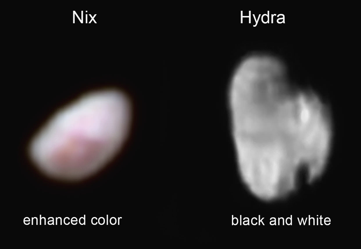
Pluto’s moon Nix (left), shown here in enhanced color as imaged by the New Horizons Ralph instrument, has a reddish spot that has attracted the interest of mission scientists. The data were obtained on the morning of July 14, 2015, and received on the ground on July 18. At the time the observations were taken New Horizons was about 102,000 miles (165,000 km) from Nix. The image shows features as small as approximately 2 miles (3 kilometers) across on Nix, which is estimated to be 26 miles (42 kilometers) long and 22 miles (36 kilometers) wide.
Pluto's small, irregularly shaped moon Hydra (right) is revealed in this black and white image taken from New Horizons' LORRI instrument on July 14, 2015 from a distance of about 143,000 miles (231,000 kilometers). Features as small as 0.7 miles (1.2 kilometers) are visible on Hydra, which measures 34 miles (55 kilometers) in length.
Credit: NASA/Johns Hopkins University Applied Physics Laboratory/Southwest Research Institute
Of course they’ve always been real worlds. They just never looked that way. We’ve only known of their existence since 2005, when astronomers with the Pluto Companion Search Team spotted them using the Hubble Space Telescope. Never more than faint points of light, each is now revealed as a distinct, if tiny, world.
“Before last week, Hydra was just a faint point of light, so it’s a surreal experience to see it become an actual place, as we see its shape and spot recognizable features on its surface for the first time,” said New Horizons mission science collaborator Ted Stryk.
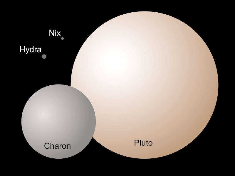
Nix and Hydra compared to “giants” Pluto and its largest moon Charon. Pluto measures 1,473 miles in diameter and Charon 790 miles. A. Stern (SwRI) and Z. Levay (STScI)
Nix looks like a strawberry-flavored jelly bean, but that reddish region with its vaguely bulls-eye shape hints at a possible crater on this 26 miles (42 km) long by 22 miles (36 km) wide moon. Hydra, which measures 34 x 25 miles (55 x 40 km), displays two large craters, one tilted to face the Sun (top) and the other almost fully in shadow. Differences in brightness across Hydra suggest differences in surface composition.
Now we’ve seen three of Pluto’ family of five satellites. Expect images of Pluto’s most recently discovered moons, Styx and Kerberos, to be transmitted to Earth no later than mid-October.
Formation of Pluto’s moons. 1: a Kuiper belt object approaches Pluto; 2: it impacts Pluto; 3: a dust ring forms around Pluto; 4: the debris aggregates to form Charon; 5: Pluto and Charon relax into spherical bodies. Smaller pieces became the irregularly-shaped moons Nix, Hydra, Kerberos and Styx. Credit: Wikipedia
All of Pluto’s satellites are believed to have been created in what’s now referred to as “The Big Whack”, a long-ago collision between Pluto and another planetary body. A similar scenario probably played out at Earth as well, leading to the formation of our own Moon. In Pluto’s case, most of the material pulled together to form Charon; the leftover chips became the smaller satellites. Their sizes are too small for self-gravity to crush them into spheres, hence their irregular shapes. The moons’ neatly circular orbits about Pluto suggest they formed together rather than being captured willy-nilly from the Kuiper Belt.
A newly discovered mountain range lies near the southwestern margin of Pluto’s Tombaugh Regio (Tombaugh Region), situated between bright, icy plains and dark, heavily-cratered terrain (left). This image taken on July 14, 2015 from a distance of 48,000 miles (77,000 km) and received on Earth on July 20. Features as small as a half-mile (1 km) across are visible. Credits: NASA/JHUAPL/SWRI
Update: This just in. Take a look at this new close-up of Pluto that features a newly discovered mountain range in southwestern Tombaugh Regio. Sure looks like ice flows. This is a complex little dwarf planet!
Below we have a special treat just in this morning (July 22) — mosaics and montages of Pluto and family created by Damian Peach from New Horizons images. Be sure to click to see the hi-res versions. Enjoy!
Close up mosaic of a part of Tombaugh Regio created by Damian Peach using New Horizons imageryThe Pluto system with Charon (upper right), Nix and Hydra. Credit: NASA, Damian PeachViews of Pluto during New Horizons’ approach. Credit: NASA/Damian PeachCharon approach from New Horizons. Credit: NASA/Damian Peach
The SpaceX Falcon 9 rocket and Dragon cargo spaceship dazzled in the moments after liftoff from Cape Canaveral, Florida, on June 28, 2015 but were soon doomed to a sudden catastrophic destruction barely two minutes later in the inset photo (left). Composite image includes up close launch photo taken from pad camera set at Space Launch Complex 40 at Cape Canaveral and mid-air explosion photo taken from the roof of the Vehicle Assembly Building (VAB) at NASA’s Kennedy Space Center, Florida as rocket was streaking to the International Space Station (ISS) on CRS-7 cargo resupply mission. Credit: Ken Kremer/kenkremer.com
The in-flight failure of a critical support strut inside the second stage liquid oxygen tank holding a high pressure helium tank in the Falcon 9 rocket, is the likely cause of the failed SpaceX launch three weeks ago on June 28, revealed SpaceX CEO and chief designer Elon Musk during a briefing for reporters held today, July 20, to explain why the critical cargo delivery run for NASA to the space station suddenly turned into a total disaster after a promising start.
The commercial booster and its cargo Dragon payload were unexpectedly destroyed by an overpressure event 139 seconds after a picture perfect blastoff from Space Launch Complex 40 at Cape Canaveral Air Force Station in Florida on June 28 at 10:21 a.m. EDT.
Musk emphasized that the failure analysis is still “preliminary” and an “initial assessment” based on the investigation thus far. SpaceX has led the investigation efforts under the oversight of the FAA with participation from prime customers NASA and the U.S. Air Force.
The root cause appears to be that the second stage strut holding the high pressure helium tank inside the 2nd stage broke at a bolt – far below its design specification and thereby allowing the tank to break free and swing away.
“The strut that we believe failed was designed and certified to handle 10,000 lbs of force, but failed at 2,000 lbs, a five-fold difference,” Musk explained.
“During acceleration of the rocket to 3.2 G’s, the strut holding down the helium tank failed. Helium was released, causing the over pressurization event.”
To date no other issues have been identified as possible failure modes, Musk elaborated.
The helium tanks are pressurized to 5500 psi and were breached during the over pressurization. The purpose of the helium tanks is to pressurize the first and second stage propellant tanks.
SpaceX Falcon 9 rocket explodes about 2 minutes after liftoff from Cape Canaveral Air Force Station in Florida on June 28, 2015. Credit: Ken Kremer/kenkremer.com
“We tested several hundred struts. On the outside they looked normal. But inside there was a problem,” Musk explained
“Detailed close-out photos of stage construction show no visible flaws or damage of any kind,” according to a SpaceX statement.
The struts are produced by an outside vendor that Musk would not identify. He added that in the future, SpaceX will likely choose a different vendor to manufacture the struts.
He said the struts were made from a type of stainless steel and would also likely be redesigned.
“The material of construction will be changed to Inconel,” Musk told me in response to a question.
Hundreds of the original type struts have been used to date on the first and second stages of the Falcon 9 with no issues. In the future, they will also be independently certified for use, by an outside contractor instead of the vendor.
The nine first stage Merlin 1D engines of the Falcon 9 were still firing nominally during the start of the mishap, said Musk. The first stage had nearly completed its planned firing duration when the explosion took place.
“The event happened very quickly, within 0.893 seconds,” Musk stated, from the first indication of an issue to loss of all telemetry.
“Preliminary analysis suggests the overpressure event in the upper stage liquid oxygen tank was initiated by a flawed piece of support hardware (a “strut”) inside the second stage,” noted SpaceX in a statement.
Video caption: Launch video of the CRS-7 launch on June 28, 2015 from a remote camera placed at Launch Complex 40. The launch would fail around two minutes later. Credit: Alex Polimeni/Spaceflight Now
The blastoff of the Dragon CRS-7 cargo mission for NASA was the first failure of the SpaceX Falcon 9 rocket after 18 straight successes and the firms first launch mishap since the failure of a Falcon 1 in 2008.
The SpaceX CRS-7 Dragon was loaded with over 4,000 pounds (1987 kg) of research experiments, an EVA spacesuit, water filtration equipment, spare parts, gear, computer equipment, high pressure tanks of oxygen and nitrogen supply gases, food, water and clothing for the astronaut and cosmonaut crews comprising Expeditions 44 and 45.
Umbilicals away and detaching from SpaceX Falcon 9 launch from Cape Canaveral, Florida, on June 28, 2015 that was doomed to disaster soon thereafter. Credit: Ken Kremer/kenkremer.com
The Dragon cargo freighter survived the explosion but was destroyed when it impacted the Atlantic Ocean.
“But the Dragon might have been saved if the parachutes had been deployed,” said Musk.
Unfortunately the software required to deploy the parachute was not loaded onboard.
“The new software required to deploy the parachutes will be included on all future Dragons, V1 and V2,” said Musk, referring to the cargo and crew versions of the SpaceX Dragon spaceship.
SpaceX Falcon 9 rocket and Dragon resupply spaceship explode about 2 minutes after liftoff from Cape Canaveral Air Force Station in Florida on June 28, 2015. Credit: Ken Kremer/kenkremer.com
The NASA cargo was valued at about $110 million. The launch itself was not insured.
The investigation board is reviewing data from over 3,000 telemetry channels as well as video and physical debris, he noted.
The next launch of a Falcon 9 will be postponed at least a few months until “no earlier than September” Musk indicated.
Two Falcon 9 launches had been set for August from Vandenberg AFB and Cape Canaveral. And the next launch to the ISS had been slated for September on the Dragon CRS-8 mission.
Musk said the next payload to be launched aboard a Falcon 9 has yet to be determined.
Overall CRS-7 was the seventh SpaceX commercial resupply services mission and the eighth trip by a Dragon spacecraft to the station since 2012.
CRS-7 marked the company’s seventh operational resupply mission to the ISS under a $1.6 Billion contract with NASA to deliver 20,000 kg (44,000 pounds) of cargo to the station during a dozen Dragon cargo spacecraft flights through 2016 under NASA’s original Commercial Resupply Services (CRS) contract.
Stay tuned here for Ken’s continuing Earth and planetary science and human spaceflight news.
SpaceX founder and CEO Elon Musk briefs reporters, including Universe Today, in Cocoa Beach, FL, during prior SpaceX Falcon 9 rocket blastoff from Cape Canaveral, FL. Credit: Ken Kremer/kenkremer.com
………….
Learn more about SpaceX, ULA, Mars rovers, Orion, Antares, MMS, NASA missions and more at Ken’s upcoming outreach events:
July 21/22: “SpaceX, Orion, Commercial crew, Curiosity explores Mars, MMS, Antares and more,” Kennedy Space Center Quality Inn, Titusville, FL, evenings/afternoon for July 22 Delta IV launch of USAF WGS-7 satellite
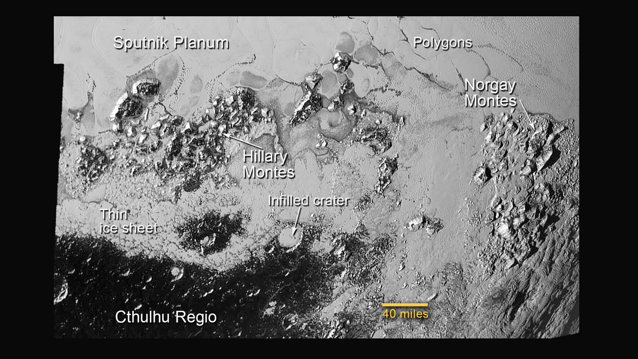
Hi Res mosaic of ‘Tombaugh Regio’ shows the heart-shaped region on Pluto and focuses on icy mountain ranges of ‘Norgay Montes’ and ice plains of ‘Sputnik Planum.’ The new mosaic combines highest resolution imagery captured by NASA’s New Horizons LORRI imager during history making closest approach flyby on July 14, 2015, draped over a wider, lower resolution view of Tombaugh Regio. Inset at left shows possible wind streaks. Inset at right shows global view of Pluto with location of huge heart-shaped region in context. Annotated with place names. Credit: NASA/JHUAPL/SWRI/ Marco Di Lorenzo/Ken Kremer/kenkremer.com
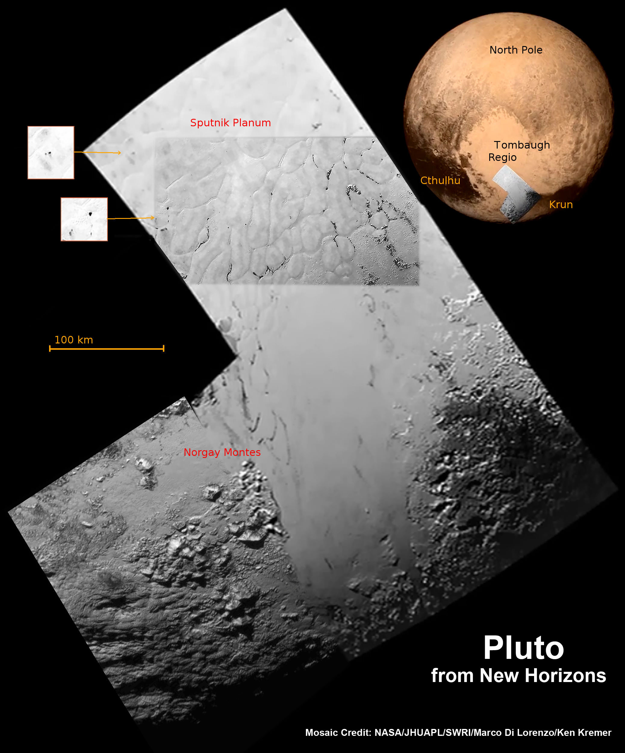
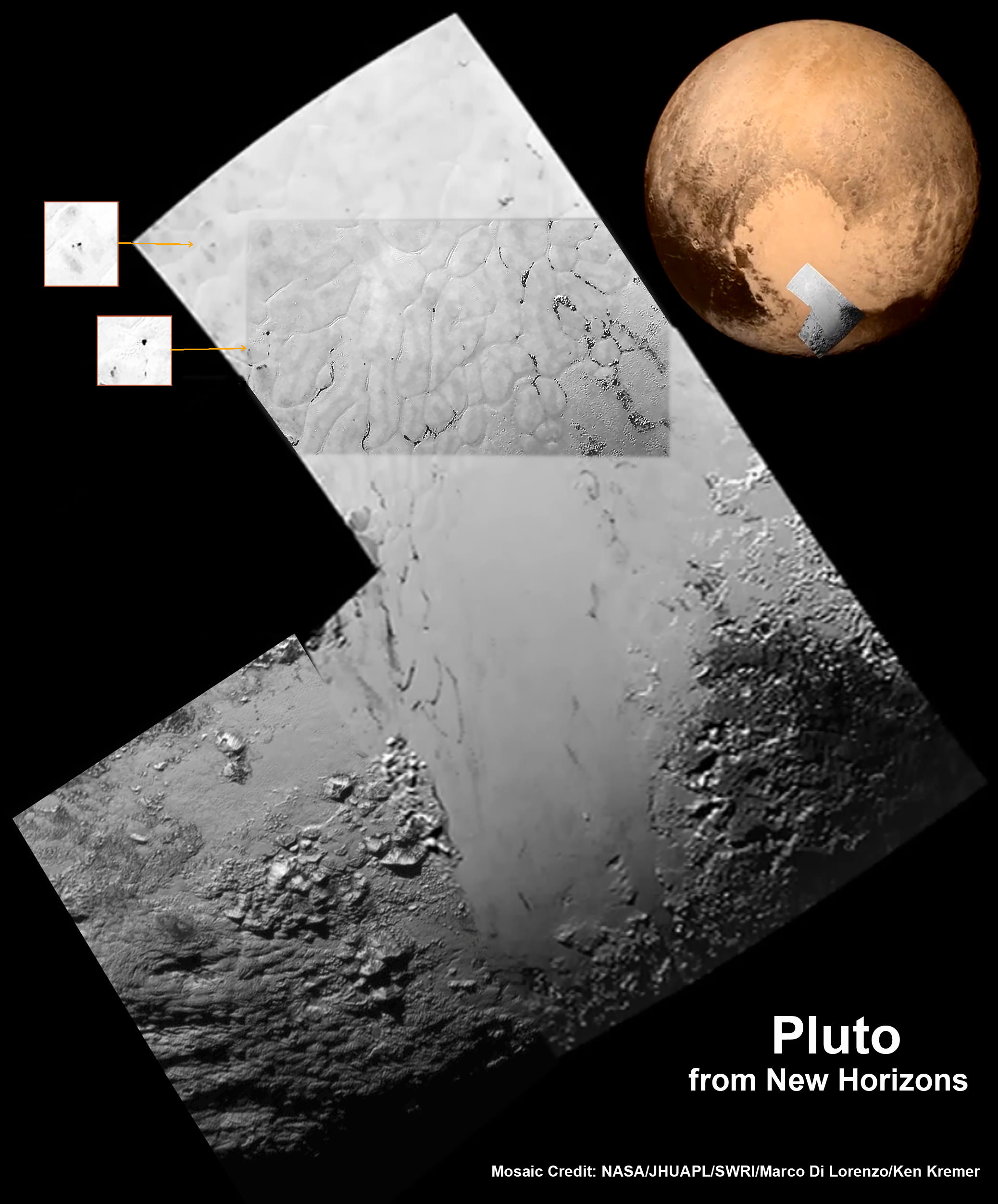
APPLIED PHYSICS LABORATORY, LAUREL, MD – The highest resolution images ever taken of Pluto by humanity’s first spacecraft ever to visit the last planet in our solar system revealed unanticipated new discoveries of ice mountains as tall as the Rockies and vast craterless plains spanning hundreds of miles (kilometers) across – are now shown in our newly created context mosaic (featured above and below) of the heart-shaped ‘Tombaugh Regio’ area that dominates the alien planet’s surface.
This first high resolution surface mosaic was created from a newly unveiled series of black and white images centered in the Heart of Pluto’s huge ‘Heart, including the ice mountains of ‘Sputnik Planum’ and icy plains of ‘Norgay Montes.’
They were captured by New Horizons’ high resolution Long Range Reconnaissance Imager (LORRI) on July 14 as the probe barreled past the Pluto-Charon binary planet system only four days ago on Tuesday, July 14, at over 31,000 mph (49,600 kph).
These highest resolution LORRI images focused on the “Heart of the Heart” of Pluto have now been stitched into a mosaic by the image processing team of Marco Di Lorenzo and Ken Kremer.
Pluto’s bright heart-shaped region has now been informally renamed “Tombaugh Regio,’ announced John Spencer, New Horizons science team co-investigator at the post flyby media briefing on July 15.
The mosaic of Pluto’s ‘Tombaugh Regio’ is based on the initial imagery released so far as of July 17.
This annotated view of a portion of Pluto’s Sputnik Planum (Sputnik Plain), named for Earth’s first artificial satellite, shows an array of enigmatic features. The surface appears to be divided into irregularly shaped segments that are ringed by narrow troughs, some of which contain darker materials. Features that appear to be groups of mounds and fields of small pits are also visible. This image was acquired by the Long Range Reconnaissance Imager (LORRI) on July 14 from a distance of 48,000 miles (77,000 kilometers). Features as small as a half-mile (1 kilometer) across are visible. Credits: NASA/JHUAPL/SWRI
A pair of high resolution LORRI images was aimed at areas now informally named Norgay Montes (Norgay Mountains) and Sputnik Planum (Sputnik Plain).
Norgay Montes is informally named for Tenzing Norgay, one of the first two humans to reach the summit of Mount Everest, along with Sir Edmund Hillary. Sputnik Planum is informally named for Earth’s first artificial satellite launched by the Soviet Union in 1957.
The two LORRI images are draped over a wider, lower resolution view of Tombaugh Regio – in annotated and unannotated versions. This is highest resolution currently available.
To the left of the mosaic are two small inserts showing possible “wind streaks” say the researchers.
To the right of the mosaic is a global view of Pluto showing the location of Tombaugh Regio and also outlined to show the precise location of the high resolution LORRI mosaic.
Hi Res mosaic of ‘Tombaugh Regio’ shows the heart-shaped region on Pluto and focuses on icy mountain ranges of ‘Norgay Montes’ and ice plains of ‘Sputnik Planum.’ The new mosaic combines highest resolution imagery captured by NASA’s New Horizons LORRI imager during history making closest approach flyby on July 14, 2015. Inset at left shows possible wind streaks. Inset at right shows global view of Pluto with location of huge heart-shaped region in context. Credit: NASA/JHUAPL/SWRI/ Marco Di Lorenzo/Ken Kremer/kenkremer.com
The LORRI images were taken from a distance of 48,000 miles (77,000 kilometers) from the surface of the planet about 1.5 hours prior to the closest approach at 7:49 a.m. EDT on July 14. The images easily resolve structures smaller than a mile across.
The frozen region of Norgay Montes is situated north of Pluto’s icy mountain range at Sputnik Planum.
“This terrain is not easy to explain,” said Jeff Moore, leader of the New Horizons Geology, Geophysics and Imaging Team (GGI) at NASA’s Ames Research Center in Moffett Field, California.
“The discovery of vast, craterless, very young plains on Pluto exceeds all pre-flyby expectations.”
“The landscape is astoundingly amazing. There are a few ancient impact craters on Pluto. But other areas like “Tombaugh Regio” show no craters. The landform change processes are occurring into current geologic times.”
“There are no impact craters in a frozen area north of Pluto’s icy mountains we are now informally calling ‘Sputnik Planum’ after Earth’s first artificial satellite.”
New close-up images of a region near Pluto’s equator reveal a giant surprise — a range of youthful mountains rising as high as 11,000 feet (3,500 meters) above the surface of the icy body. Credits: NASA/JHU APL/SwRI
‘Sputnik Planum’ is composed of a broken surface of irregularly-shaped segments. The polygonal shaped areas are roughly 12 miles (20 kilometers) across, bordered by what appear to be shallow troughs based on a quick look at the data.
The mountain ranges height rival those of the Rockies, says Moore.
The new LORRI close-ups show the icy mountain range has peaks jutting as high as 11,000 feet (3,500 meters) above the surface, announced John Spencer, New Horizons science team co-investigator at the media briefing.
“It’s a very young surface, probably formed less than 100 million years old,’ said Spencer. “It may be active now.”
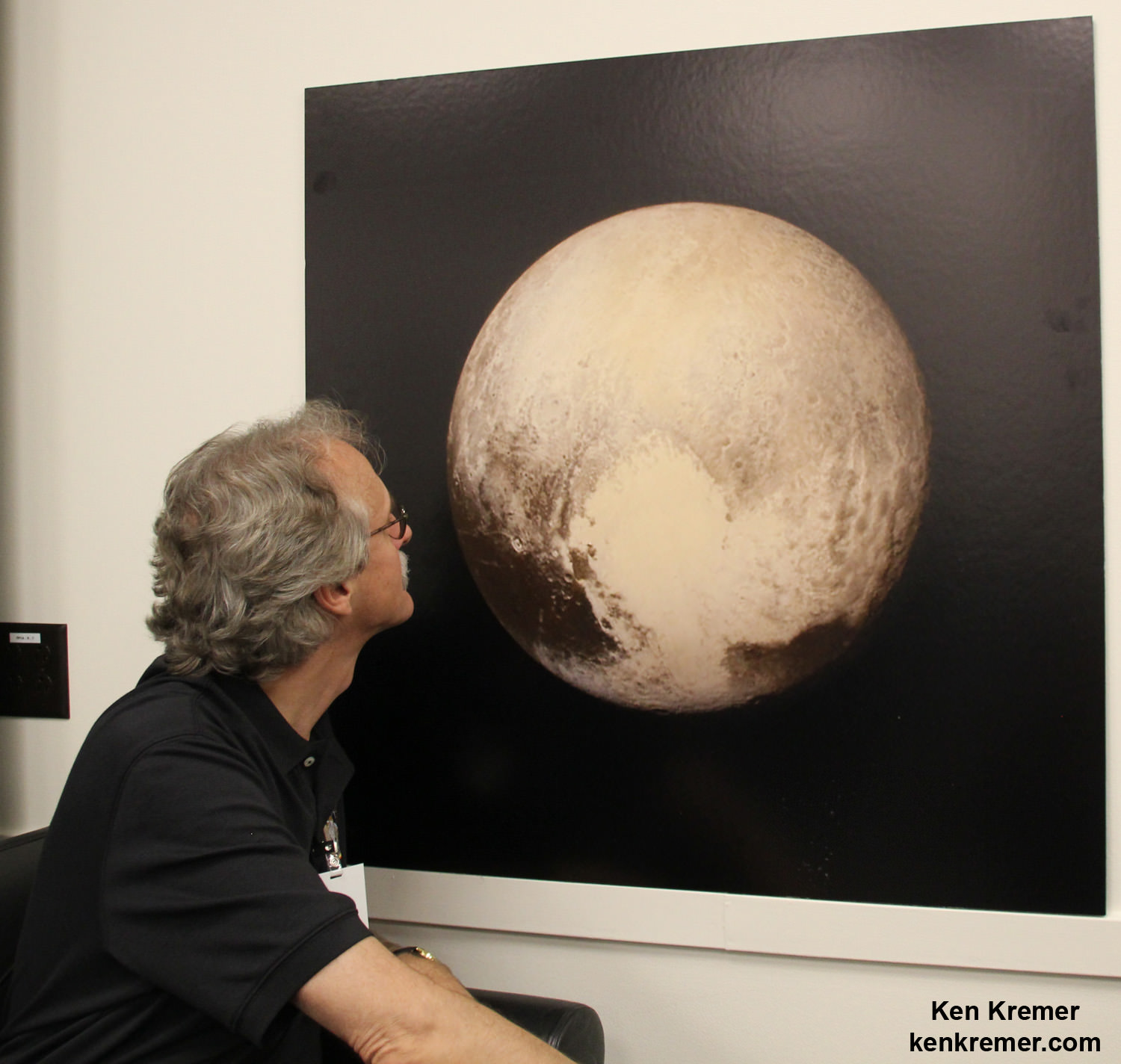
New Horizons science team co-investigator John Spencer examines print of the newest Pluto image taken on July 13, 2015 after the successful Pluto flyby. Credit: Ken Kremer/kenkremer.com
“Judging from the absence of impact craters, it’s clear that Sputnik Planum couldn’t possibly be more than 100 million years old, and possibly is still being shaped to this day by geologic processes,” noted Moore. “This could be only a week old for all we know.”
During the fast flyby encounter, the New Horizons spacecraft pointed its suite of seven science instruments exclusively on all the bodies in the Pluto system, to maximize the capture of scientific data, as quickly as possible, and store it onto its two solid state digital recorders for later playback.
A major challenge for the mission is the rather slow “downlink” transmission of data back to Mission Control on Earth. Since the average “downlink” is only about 2 kilobits per second via its two transmitters, it will take about 16 months to send all the flyby data back to Earth.
Therefore the team has carefully selected just a few of the highest resolution images and other key instrument data for quick playback. The remaining flyby data will be prioritized for streaming.
“Over 50 gigabits of data were collected during the encounter and flyby periods,” New Horizons principal investigator Alan Stern of the Southwest Research Institute, Boulder, Colorado, said during the July 17 media briefing.
“So far less than 1 gigabit of data has been returned.”
New Horizons discovered that Pluto is the biggest object in the outer solar system and thus the ‘King of the Kuiper Belt’.
The Kuiper Belt comprises the third and outermost region of worlds in our solar system.
If the spacecraft remains healthy as expected, the science team plans to target New Horizons to fly by another smaller Kuiper Belt Object (KBO) as soon as 2018.
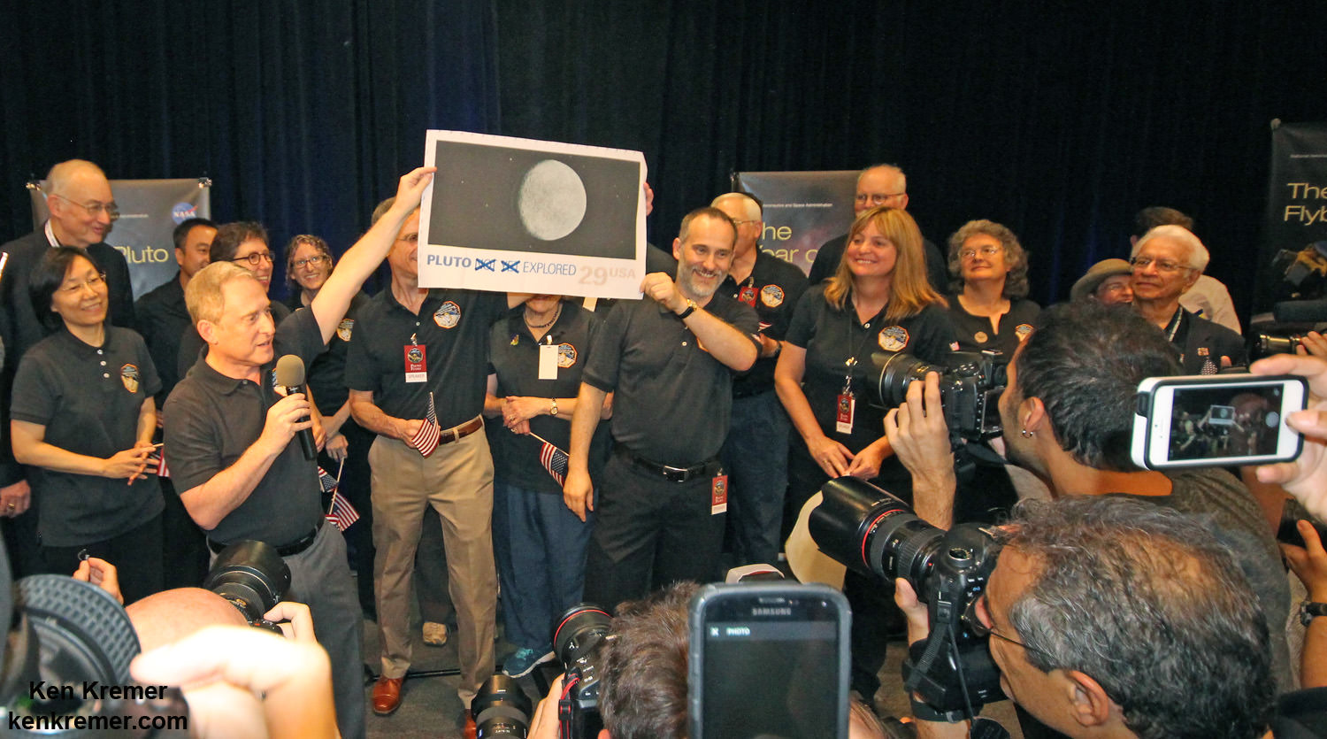
Pluto Explored at Last. The New Horizons mission team celebrates successful flyby of Pluto in the moments after closest approach at 7:49 a.m. EDT on July 14, 2015. New Horizons Principal Investigator Alan Stern of Southwest Research Institute (SwRI), Boulder, CO., left, Johns Hopkins University Applied Physics Laboratory (APL) Director Ralph Semmel, center, and New Horizons Co-Investigator Will Grundy Lowell Observatory hold an enlarged print of an U.S. stamp with their suggested update after Pluto became the final planet in our solar system to be explored by an American space probe (crossing out the words ‘not yet’) – at the Johns Hopkins University Applied Physics Laboratory (APL) in Laurel, Maryland. Credit: Ken Kremer/kenkremer.com
Watch for Ken’s continuing coverage of the Pluto flyby. He was onsite reporting live on the flyby and media briefings for Universe Today from the Johns Hopkins University Applied Physics Laboratory (APL), in Laurel, Md.
Stay tuned here for Ken’s continuing Earth and planetary science and human spaceflight news.
NASA Associate Administrator for the Science Mission Directorate John Grunsfeld, left, New Horizons Principal Investigator Alan Stern of Southwest Research Institute (SwRI), Boulder, CO, second from left, New Horizons Mission Operations Manager Alice Bowman of the Johns Hopkins University Applied Physics Laboratory (APL), second from right, and New Horizons Project Manager Glen Fountain of APL, right, are seen at the conclusion of a press conference after the team received confirmation from the spacecraft that it has completed the flyby of Pluto, Tuesday, July 14, 2015 at the Johns Hopkins University Applied Physics Laboratory (APL) in Laurel, Maryland. Credit: Ken Kremer/kenkremer.com
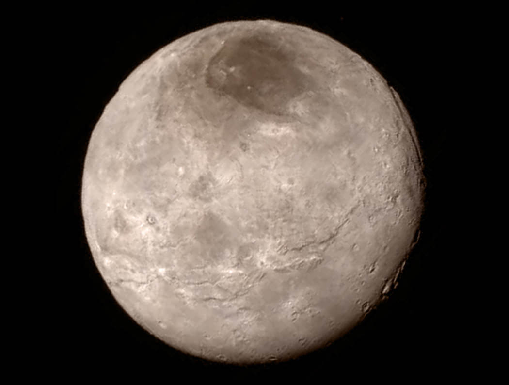
This new image of an area on Pluto's largest moon Charon has a captivating feature -- a depression with a peak in the middle, shown here in the upper left corner of the inset. The image shows an area approximately 240 miles (390 kilometers) from top to bottom, including few visible craters. The image was taken at approximately 6:30 a.m. EDT on July 14, 2015, about 1.5 hours before closest approach to Pluto, from a range of 49,000 miles (79,000 kilometers). Credits: NASA-JHUAPL-SwRI
This new image of an area on Pluto’s largest moon Charon has a captivating feature — a depression with a peak in the middle, shown here in the upper left corner of the inset. The image shows an area approximately 240 miles (390 kilometers) from top to bottom, including few visible craters. The image was taken at approximately 6:30 a.m. EDT on July 14, 2015, about 1.5 hours before closest approach to Pluto, from a range of 49,000 miles (79,000 kilometers). Credits: NASA-JHUAPL-SwRI
Story updated[/caption]
APPLIED PHYSICS LABORATORY, LAUREL, MD – A mysterious mountain in the middle of a moat on Pluto’s biggest moon Charon, has captivated and baffled scientists leading NASA’s New Horizons mission which made history when it became the first spacecraft to visit our solar system’s most distant planet barely two days ago on Tuesday morning, July 14, 2015.
NASA released the first close-up image of Charon today (July 16), shown above, and it has the geology team scratching their heads in amazement and wonder. They can’t figure out the nature of a big mountain set inside a moat.
The new image shows a depression with a mountain peak in the middle.
“The most intriguing feature is a large mountain sitting in a moat,” said Jeff Moore with NASA’s Ames Research Center, Moffett Field, California, who leads New Horizons’ Geology, Geophysics and Imaging team. “This is a feature that has geologists stunned and stumped.”
The location of the “mountain in a moat” is shown in the inset of a global view of Charon.
The new high resolution image of Charon was taken at approximately 6:30 a.m. EDT (10:30 UTC), barely an hour and a half before the piano-shaped spacecraft’s closest approach to Pluto on July 14, 2015, from a range of only 49,000 miles (79,000 kilometers).
The image was captured by New Horizons’ high resolution Long Range Reconnaissance Imager (LORRI).
Pluto Explored at Last
The New Horizons mission team celebrates successful flyby of Pluto in the moments after closest approach at 7:49 a.m. EDT on July 14, 2015. New Horizons Principal Investigator Alan Stern of Southwest Research Institute (SwRI), Boulder, CO., left, Johns Hopkins University Applied Physics Laboratory (APL) Director Ralph Semmel, center, and New Horizons Co-Investigator Will Grundy Lowell Observatory hold an enlarged print of an U.S. stamp with their suggested update after Pluto became the final planet in our solar system to be explored by an American space probe (crossing out the words ‘not yet’) – at the Johns Hopkins University Applied Physics Laboratory (APL) in Laurel, Maryland. Credit: Ken Kremer/kenkremer.com
A much sharper view is yet to come, because the image is heavily compressed.
“Sharper versions are anticipated when the full-fidelity data from New Horizons’ Long Range Reconnaissance Imager (LORRI) are returned to Earth,” say NASA officials.
The area in the LORRI image comprises an area approximately 240 miles (390 kilometers) from top to bottom.
Crisp new view of Pluto’s largest moon, Charon shows a swath of cliffs and troughs stretches about 600 miles (1,000 kilometers) from left to right, suggesting widespread fracturing of Charon’s crust, likely a result of internal processes. At upper right, along the moon’s curving edge, is a canyon estimated to be 4 to 6 miles (7 to 9 kilometers) deep. Credit: NASA-JHUAPL-SwRI
Notably there are few visible craters “indicating a relatively young surface that has been reshaped by geologic activity.”
And a “swath of cliffs and troughs stretching about 600 miles (1,000 kilometers) suggests widespread fracturing of Charon’s crust, likely the result of internal geological processes,” notes the team.
The Texas-sized moon measures about 750 miles (1200 kilometers) across, about half the diameter of Pluto. Pluto spans 1,471 miles (2,368 km) across.
After a nine year voyage through interplanetary space, New Horizons barreled past the Pluto system on Tuesday, July 14 for a history making first ever flyby at over 31,000 mph (49,600 kph), and survived the passage by swooping barely 7,750 miles (12,500 kilometers) above the planet’s amazingly diverse surface at 7:49 a.m. EDT. It passed about 17,900 miles (28,800 kilometers) from Charon during closest approach.
NASA Administrator Charles Bolden congratulates the New Horizons team after successful Pluto flyby on July 14, 2015, to cheering crowd at the Johns Hopkins University Applied Physics Laboratory (APL) in Laurel, Maryland, during live NASA TV media briefing. Credit: Ken Kremer/kenkremer.com
Watch for Ken’s continuing coverage of the Pluto flyby on July 14. He was onsite reporting live on the flyby and media briefing from the Johns Hopkins University Applied Physics Laboratory (APL).
New images will be released on Friday, July 17 – watch for my story.
Stay tuned here for Ken’s continuing Earth and planetary science and human spaceflight news.
Chasms, craters, and a dark north polar region are revealed in this image of Pluto’s largest moon Charon taken by New Horizons on July 11, 2015. The annotated version includes a diagram showing Charon’s north pole, equator, and central meridian, with the features highlighted. Credits: NASA/JHUAPL/SWRI
New close-up images of a region near Pluto’s equator reveal a giant surprise -- a range of youthful mountains rising as high as 11,000 feet (3,500 meters) above the surface of the icy body. Credits: NASA/JHU APL/SwRI
New close-up images of a region near Pluto’s equator reveal a giant surprise — a range of youthful mountains rising as high as 11,000 feet (3,500 meters) above the surface of the icy body. Credits: NASA/JHU APL/SwRI
Story/photos expanded[/caption]
APPLIED PHYSICS LABORATORY, LAUREL, MD – Scientists leading NASA’s historic New Horizons mission to the Pluto system announced the first of what is certain to be a tidal wave of new discoveries, including the totally unexpected finding of young ice mountains at Pluto and crispy clear views of young fractures on its largest moon Charon, at a NASA media briefing today (July 15) at the Applied Physics Laboratory (APL) in Laurel, Maryland.
A treasure trove of long awaited data has begun streaming back to Mission Control at Johns Hopkins University Applied Physics Laboratory to the mouth watering delight of researchers and NASA.
With the first ever flyby of Pluto, America completed the initial up close reconnaissance of the planets in our solar system. Pluto was the last unexplored planet, building on missions that exactly started 50 years ago in 1965 when Mariner IV flew past Mars.
“Pluto New Horizons is a true mission of exploration showing us why basic scientific research is so important,” said John Grunsfeld, associate administrator for NASA’s Science Mission Directorate in Washington.
“The mission has had nine years to build expectations about what we would see during closest approach to Pluto and Charon. Today, we get the first sampling of the scientific treasure collected during those critical moments, and I can tell you it dramatically surpasses those high expectations.”
Crisp new view of Pluto’s largest moon, Charon shows a swath of cliffs and troughs stretches about 600 miles (1,000 kilometers) from left to right, suggesting widespread fracturing of Charon’s crust, likely a result of internal processes. At upper right, along the moon’s curving edge, is a canyon estimated to be 4 to 6 miles (7 to 9 kilometers) deep. Credit: NASA-JHUAPL-SwRI
Today the team announced that New Horizons has already made a totally unexpected discovery showing clear evidence of ice mountains on Pluto’s surface in the bright area informally known as the ‘big heart of Pluto.’
The new close-up image released today showed an icy mountain range near the base of the heart with peaks jutting as high as 11,000 feet (3,500 meters) above the surface, announced John Spencer, New Horizons science team co-investigator at the media briefing.
“It’s a very young surface, probably formed less than 100 million years old,’ said Spencer. “It may be active now.”
Spencer also announce that the heart shaped region will now be named “Tombaugh Reggio” in honor of Clyde Tombaugh, the American astronomer who discovered Pluto in 1930.
“We are seeing water ice.”
“I never would have imagined this!” Spencer exclaimed.
“And I’m very surprised that there are no craters in the first high resolution images.”
Pluto nearly fills the frame in this image from the Long Range Reconnaissance Imager (LORRI) aboard NASA’s New Horizons spacecraft, taken on July 13, 2015 when the spacecraft was 476,000 miles (768,000 kilometers) from the surface. This is the last and most detailed image sent to Earth before the spacecraft’s closest approach to Pluto on July 14. The large, heart-shaped region is front and center. Several craters are seen and much of the surface looks reworked rather than ancient. Credit: NASA-JHUAPL-SwRI
The finding of ice mountains has major scientific implications.
Unlike the icy moons of giant planets, Pluto cannot be heated by gravitational interactions with a much larger planetary body. Some other process must be generating the mountainous landscape, said the team.
“This may cause us to rethink what powers geological activity on many other icy worlds,” says Spencer of SwRI.
NASA announces discovery of icy mountain ranges on Pluto at July 15 media briefing at Johns Hopkins University Applied Physics Laboratory. Credit: Ken Kremer/kenkremer.com
“Pluto may have internal activity. There may be geysers or cryovolcanoes,” New Horizons principal investigator Alan Stern of the Southwest Research Institute, Boulder, Colorado, said during the media briefing. However there is no evidence for them yet.
Additional high resolution images for “Tombaugh Reggio” area are being transmitted back to Earth today and will continue.
“Finding a mountain range of ice is a complete surprise,” Stern noted.
After a nine year voyage through interplanetary space, New Horizons barreled past the Pluto system on Tuesday, July 14 for a history making first ever flyby at over 31,000 mph (49,600 kph), and survived the passage by swooping barely 7,750 miles (12,500 kilometers) above the planet’s amazingly diverse surface.
The team had to wait another 12 hours for confirmation that the spacecraft lived through the daring encounter when signals were reacquired as planned at 8:53 p.m. EDT last night. Since New Horizons swung past Pluto to continue its voyage, the probe is now more than million miles outbound just 24 hours later.
NASA Associate Administrator for the Science Mission Directorate John Grunsfeld, left, New Horizons Principal Investigator Alan Stern of Southwest Research Institute (SwRI), Boulder, CO, second from left, New Horizons Mission Operations Manager Alice Bowman of the Johns Hopkins University Applied Physics Laboratory (APL), second from right, and New Horizons Project Manager Glen Fountain of APL, right, are seen at the conclusion of a press conference after the team received confirmation from the spacecraft that it has completed the flyby of Pluto, Tuesday, July 14, 2015 at the Johns Hopkins University Applied Physics Laboratory (APL) in Laurel, Maryland. Credit: Ken Kremer/kenkremer.com
The New Frontiers spacecraft was built by a team led by Stern and included researchers from SwRI and the Johns Hopkins University Applied Physics Laboratory (APL) in Laurel, Maryland. APL also operates the New Horizons spacecraft and manages the mission.
NASA Administrator Charles Bolden congratulates the New Horizons team after successful Pluto flyby on July 14, 2015, to cheering crowd at the Johns Hopkins University Applied Physics Laboratory (APL) in Laurel, Maryland, during live NASA TV media briefing. Credit: Ken Kremer/kenkremer.com
Watch for Ken’s continuing onsite coverage of the Pluto flyby on July 14 from the Johns Hopkins University Applied Physics Laboratory (APL).
Stay tuned here for Ken’s continuing Earth and planetary science and human spaceflight news.
New Horizons science team co-investigator John Spencer examines print of the newest Pluto image taken on July 13, 2015 after the successful Pluto flyby. Credit: Ken Kremer/kenkremer.com