25 Years Since Voyager’s ‘Pale Blue Dot’ Images

These six narrow-angle color images were made from the first ever "portrait" of the solar system taken by Voyager 1 on Valentine’s Day on Feb. 14, 1990, which was more than 4 billion miles from Earth and about 32 degrees above the ecliptic. Venus, Earth, Jupiter, and Saturn, Uranus, Neptune are seen in these blown-up images, from left to right and top to bottom. Credit: NASA/JPL-Caltech

A quarter of a century has passed since NASA’s Voyager 1 spacecraft snapped the iconic image of Earth known as the “Pale Blue Dot” that shows all of humanity as merely a tiny point of light.

The outward bound Voyager 1 space probe took the ‘pale blue dot’ image of Earth 25 years ago on Valentine’s Day, on Feb. 14, 1990 when it looked back from its unique perch beyond the orbit of Neptune to capture the first ever “portrait” of the solar system from its outer realms.

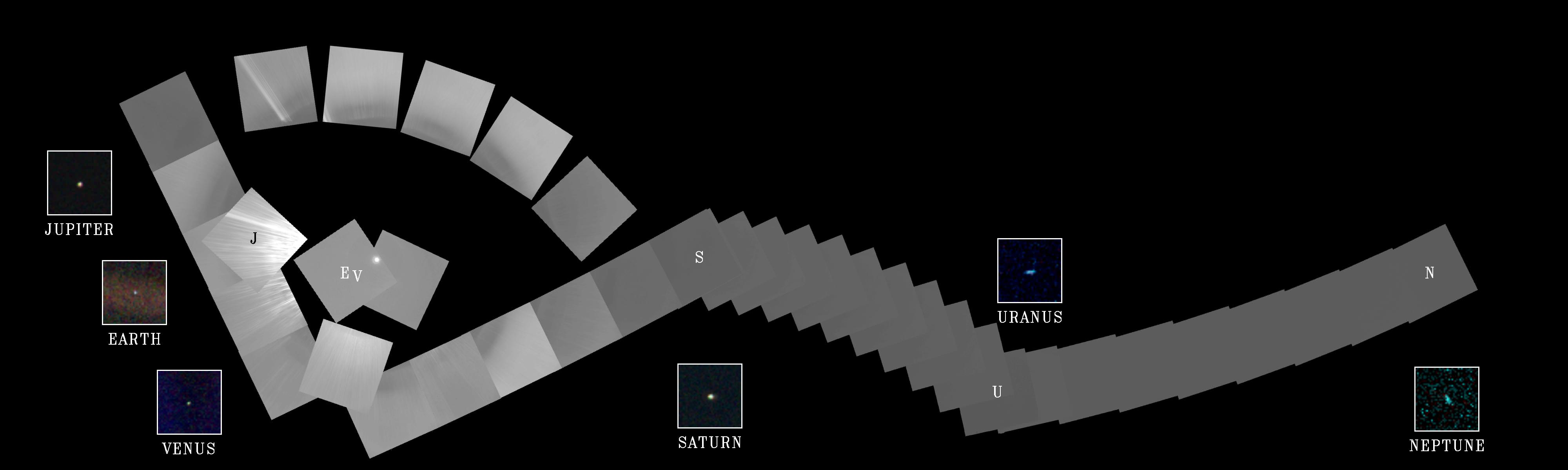
Voyager 1 was 4 billion miles from Earth, 40 astronomical units (AU) from the sun and about 32 degrees above the ecliptic at that moment.

The idea for the images came from the world famous astronomer Carl Sagan, who was a member of the Voyager imaging team at the time.

He head the idea of pointing the spacecraft back toward its home for a last look as a way to inspire humanity. And to do so before the imaging system was shut down permanently thereafter to repurpose the computer controlling it, save on energy consumption and extend the probes lifetime, because it was so far away from any celestial objects.

Sagan later published a well known and regarded book in 1994 titled “Pale Blue Dot,” that refers to the image of Earth in Voyagers series.

This narrow-angle color image of the Earth, dubbed "Pale Blue Dot," is a part of the first ever "portrait" of the solar system taken by Voyager 1 on Valentine’s Day on Feb. 14, 1990.  Credit: NASA/JPL-Caltech
This narrow-angle color image of the Earth, dubbed “Pale Blue Dot,” is a part of the first ever “portrait” of the solar system taken by Voyager 1 on Valentine’s Day on Feb. 14, 1990. Credit: NASA/JPL-Caltech

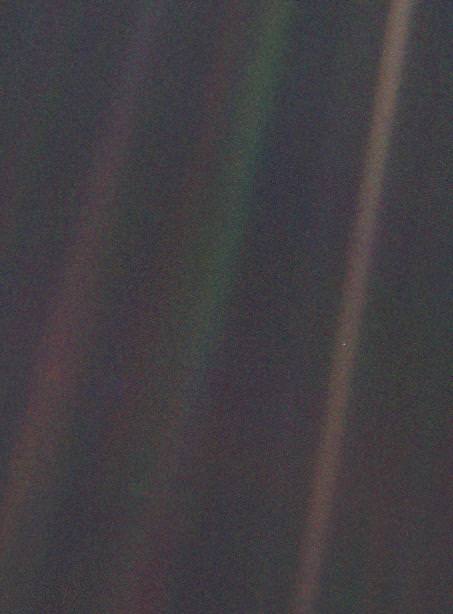
“Twenty-five years ago, Voyager 1 looked back toward Earth and saw a ‘pale blue dot,’ ” an image that continues to inspire wonderment about the spot we call home,” said Ed Stone, project scientist for the Voyager mission, based at the California Institute of Technology, Pasadena, in a statement.

Six of the Solar System’s nine known planets at the time were imaged, including Venus, Earth, Jupiter, and Saturn, Uranus, Neptune. The other three didn’t make it in. Mercury was too close to the sun, Mars had too little sunlight and little Pluto was too dim.

Voyager snapped a series of images with its wide angle and narrow angle cameras. Altogether 60 images from the wide angle camera were compiled into the first “solar system mosaic.”

Voyager 1 was launched in 1977 from Cape Canaveral Air Force Station in Florida as part of a twin probe series with Voyager 2. They successfully conducted up close flyby observations of the gas giant outer planets including Jupiter, Saturn, Uranus and Neptune in the 1970s and 1980s.

Both probes still operate today as part of the Voyager Interstellar Mission.

“After taking these images in 1990, we began our interstellar mission. We had no idea how long the spacecraft would last,” Stone said.

Hurtling along at a distance of 130 astronomical units from the sun, Voyager 1 is the farthest human-made object from Earth.

Solar System Portrait - 60 Frame Mosaic. The cameras of Voyager 1 on Feb. 14, 1990, pointed back toward the sun and took a series of pictures of the sun and the planets, making the first ever "portrait" of our solar system as seen from the outside.   Missing are Mercury, Mars and Pluto Credit:  NASA/JPL-Caltech
Solar System Portrait – 60 Frame Mosaic. The cameras of Voyager 1 on Feb. 14, 1990, pointed back toward the sun and took a series of pictures of the sun and the planets, making the first ever “portrait” of our solar system as seen from the outside. Missing are Mercury, Mars and Pluto. Credit: NASA/JPL-Caltech

Voyager 1 still operates today as the first human made instrument to reach interstellar space and continues to forge new frontiers outwards to the unexplored cosmos where no human or robotic emissary as gone before.

Here’s what Sagan wrote in his “Pale Blue Dot” book:

“That’s here. That’s home. That’s us. On it everyone you love, everyone you know, everyone you ever heard of, every human being who ever was, lived out their lives. … There is perhaps no better demonstration of the folly of human conceits than this distant image of our tiny world.”

Stay tuned here for Ken’s continuing Earth and planetary science and human spaceflight news.

Ken Kremer

Space Weather Storm Monitoring Satellite Blasts off for Deep Space on SpaceX Rocket

NOAA's DSCOVR satellite launches from Cape Canaveral Air Force Station on Feb. 11, 2015. DSCOVR will provide NOAA space weather forecasters more reliable measurements of solar wind conditions, improving their ability to monitor potentially harmful solar activity. Credit: Alan Walters/AmericaSpace

After a 17 year long wait, a new American mission to monitor intense solar storms and warn of impeding space weather disruptions to vital power grids, telecommunications satellites and public infrastructure was launched atop a SpaceX Falcon 9 on Wednesday, Feb. 11, from Cape Canaveral, Florida, to start a million mile journey to its deep space observation post.

The third time proved to be the charm when the Deep Space Climate Observatory, or DSCOVR science satellite lifted off at 6:03 p.m. EST Wednesday from Space Launch Complex 40 at Cape Canaveral Air Force Station in Florida.

The spectacular sunset blastoff came after two scrubs this week forced by a technical problem with the Air Force tracking radar and adverse weather on Sunday and Tuesday.

The $340 million DSCOVR has a critical mission to monitor the solar wind and aid very important forecasts of space weather at Earth at an observation point nearly a million miles from Earth. It will also take full disk color images of the sunlit side of Earth at least six times per day that will be publicly available and “wow” viewers.

Launch of NOAA DSCOVR satellite from Cape Canaveral Air Force Station on Feb. 11, 2015 to monitor solar storms and space weather.   Credit:  Julian Leek
Launch of NOAA DSCOVR satellite from Cape Canaveral Air Force Station on Feb. 11, 2015 to monitor solar storms and space weather. Credit: Julian Leek

The couch sized probe was targeted to the L1 Lagrange Point, a neutral gravity point that lies on the direct line between Earth and the sun located 1.5 million kilometers (932,000 miles) sunward from Earth. At L1 the gravity between the sun and Earth is perfectly balanced and the satellite will orbit about that spot just like a planet.

L1 is a perfect place for the science because it lies outside Earth’s magnetic environment. The probe will measure the constant stream of solar wind particles from the sun as they pass by.

The DSCOVR spacecraft (3-axis stabilized, 570 kg) will be delivered to the Sun-Earth L1 point, 1.5 million km (1 million miles) from the Earth, directly in front of the Sun. A Halo (Lissajous) orbit will stabilize the craft's position around the L1 point while keeping it outside the radio noise emanating from the Sun. (Illustratin Credit: NASA)
The DSCOVR spacecraft (3-axis stabilized, 570 kg) will be delivered to the Sun-Earth L1 point, 1.5 million km (1 million miles) from the Earth, directly in front of the Sun. A Halo (Lissajous) orbit will stabilize the craft’s position around the L1 point while keeping it outside the radio noise emanating from the Sun. (Illustratin Credit: NASA)

DSCOVR is a joint mission between NOAA, NASA, and the U.S Air Force (USAF) that will be managed by NOAA. The satellite and science instruments are provided by NASA and NOAA. The rocket was funded by the USAF.

The mission is vital because its solar wind observations are crucial to maintaining accurate space weather forecasts to protect US infrastructure such as power grids, aviation, planes in flight, all types of Earth orbiting satellites for civilian and military needs, telecommunications, ISS astronauts and GPS systems.

It will take about 150 days to reach the L1 point and complete satellite and instrument checkouts.

DSCOVR will then become the first operational space weather mission to deep space and function as America’s primary warning system for solar magnetic storms.

It will replace NASA’s aging Advanced Composition Explorer (ACE) satellite which is nearly 20 years old and far beyond its original design lifetime.

“DSCOVR is the latest example of how NASA and NOAA work together to leverage the vantage point of space to both understand the science of space weather and provide direct practical benefits to us here on Earth,” said John Grunsfeld, associate administrator of NASA’s Science Mission Directorate in Washington.

DSCOVR was first proposed in 1998 by then US Vice President Al Gore as the low cost ‘Triana’ satellite to take near continuous views of the Earth’s entire globe to feed to the internet as a means of motivating students to study math and science. It was eventually built as a much more capable Earth science satellite that would also conduct the space weather observations.

But Triana was shelved for purely partisan political reasons and the satellite was placed into storage at NASA Goddard and the science was lost until now.

DSCOVR mission logo.  Credit: NOAA/NASA/U.S. Air Force
DSCOVR mission logo. Credit: NOAA/NASA/U.S. Air Force

DSCOVR is equipped with a suite of four continuously operating solar science and Earth science instruments from NASA and NOAA.

It will make simultaneous scientific observations of the solar wind and the entire sunlit side of Earth.

The 750-kilogram (1250 pound) DSCOVR probe measures 54 inches by 72 inches.

Technician works on NASA Earth science instruments and Earth imaging EPIC camera (white circle) housed on NOAA/NASA Deep Space Climate Observatory (DSCOVR) inside NASA Goddard Space Flight Center clean room in November 2014.  Credit: Ken Kremer/kenkremer.com/AmericaSpace
Technician works on NASA Earth science instruments and Earth imaging EPIC camera (white circle) housed on NOAA/NASA Deep Space Climate Observatory (DSCOVR) inside NASA Goddard Space Flight Center clean room in November 2014. Credit: Ken Kremer/kenkremer.com/AmericaSpace

The two Earth science instruments from NASA are the Earth Polychromatic Imaging Camera (EPIC) and the National Institute of Standards and Technology Advanced Radiometer (NISTAR).

EPIC will provide true color spectral images of the entire sunlit face of Earth at least six times per day, as viewed from an orbit around L1. They will be publically available within 24 hours via NASA Langley.

It will view the full disk of the entire sunlit Earth from sunrise to sunset and collect a variety of science measurements including on ozone, aerosols, dust and volcanic ash, vegetation properties, cloud heights and more.

Listen to my post launch interview with the BBC about DSCOVR and ESA’s successful IXV launch on Feb. 11.

A secondary objective by SpaceX to recover the Falcon 9 first stage booster on an ocean going barge had to be skipped due to very poor weather and very high waves in the Atlantic Ocean making a safe landing impossible. The stage did successfully complete a soft landing in the ocean.

Stay tuned here for Ken’s continuing Earth and planetary science and human spaceflight news.

Ken Kremer

NOAA/NASA Deep Space Climate Observatory (DSCOVR) undergoes processing in NASA Goddard Space Flight Center clean room. Solar wind instruments at right. DSCOVER will launch in February 2015 atop SpaceX Falcon 9 rocket.  Credit: Ken Kremer/kenkremer.com/AmericaSpace
NOAA/NASA Deep Space Climate Observatory (DSCOVR) undergoes processing in NASA Goddard Space Flight Center clean room. Solar wind instruments at right. DSCOVER will launch in February 2015 atop SpaceX Falcon 9 rocket. Credit: Ken Kremer/kenkremer.com/AmericaSpace
Launch of NOAA DSCOVR satellite from Cape Canaveral Air Force Station on Feb. 11, 2015 to monitor solar storms and space weather.   Credit:  John Studwell
Launch of NOAA DSCOVR satellite from Cape Canaveral Air Force Station on Feb. 11, 2015 to monitor solar storms and space weather. Credit: John Studwell
Prelaunch view of SpaceX rocket on Cape Canaveral launch pad taken from LC-39 at the Kennedy Space Center.  Credit: Chuck Higgins
Prelaunch view of SpaceX rocket on Cape Canaveral launch pad taken from LC-39 at the Kennedy Space Center. Credit: Chuck Higgins

The Number of Asteroids We Could Visit and Explore Has Just Doubled

NASA

There’s a famous line from Shakespeare’s Hamlet that says “There are more things in heaven and Earth, Horatio, than are dreamt of in your philosophy,” and the same now holds true for brave new worlds for humans to explore.

This result was published earlier this week courtesy of the NASA/JPL Near-Earth Program Office. The study found that the number of possible asteroid targets for human exploration has now doubled from the 666 known in the first study, completed in late 2010.

Credit:
NHATS NEO asteroid discoveries by year. Credit: NASA/GFSC/Brent Barbee

This information comes from NHATS, which stands for the Near Earth Object Human Spaceflight Accessible Targets Study. Yes, it’s an acronym containing acronyms. NHATS is an automated system based out of Greenbelt, Maryland which monitors and periodically updates its list of potential target candidates for accessibility. The NHATS system data is readily accessible to the public online, and as of February 11th 2015, 1346 NHATS compliant asteroids are known.

NEO orbit types.
NEA orbit types. Credit: Brent Barbee/NASA/GSFC

This is the Holy Grail for the future of manned spaceflight, and will represent a good stepping stone (bad pun intended) for future crewed missions to Mars. Several hundred NHATS asteroids require less time and energy to reach than the Red Planet, and a few dozen even require less energy to reach than it does to enter lunar orbit.

Relative delta-V and return velocity is crucial. Apollo astronauts were subject to a blistering 11 kilometre per second reentry velocity on their return from the Moon, and future asteroid missions would be subject to the same style of trajectory on return to Earth from a solar orbit.

Mission to an NEO: a typical orbital profile. credit:
Mission to an NEO: a typical orbital profile. Credit: Brent Barbee/NASA/GSFC

The test of the Orion heat shield on reentry during last year’s EFT-1 flight was a step in this direction, and the next test will be an uncrewed launch atop an SLS rocket in September 2018. If all goes according to schedule — and NASA can successfully weather the ever-shifting political winds of multiple future changes of administration — expect to see astronauts exploring an NHATS asteroid placed in lunar orbit sometime around late 2023.

I know. “When I was a kid back in the 70’s…” we expected to be vacationing on Callisto by 2015, as well.

Brent Barbee at NASA’s Goddard Space Flight Center designed the automated NHATS system. It pulls data from a source that many comet and asteroid hunters are familiar with: JPL’s Small Bodies Database. The NHATS system then makes trajectory calculations and patches in conical solutions for possible spacecraft trajectories and actually gives potential launch window dates for future missions. Seriously, its fun to play with… you can even tailor and filter these by target dates versus maximum velocity constraints and the length of stays.

NASA/JPL
The orbit of asteroid 1943 Anteros. Credit: NASA/JPL.

The first discovered NHATS-compliant NEO was 2.3 kilometre 1943 Anteros way back in 1973, and famous alumni on the NHATS list also include 10 metre asteroid 2011 MD, which passed 12,000 kilometres from the Earth on June 27th, 2011. 2011 MD is on NASA’s short list of asteroids ideal for human exploration. Another famous asteroid on the NHATS list is 99942 Apophis which — triskaidekaphobics take note — will safely miss the Earth by 31,300 kilometres on Friday the 13th, April 2029.  More are added every day, and the growing curve of discoveries also closely mirrors the rise of automated all-sky surveys such as LINEAR, PanSTARRS and the Catalina Sky Survey, though dedicated amateurs do get in on the act occasionally as well.

To date, over 12,000 NEA asteroids are now known, and you can expect future surveys such as the Large Synoptic Survey Telescope set to see first light in 2021 to add to their ranks. The Sentinel space telescope set to launch in 2017 will also boost the known number of NEOs as it covers our sunward blind spot from an orbit interior to the Earth’s. Remember Chelyabinsk? That could actually be a great rallying cry for Sentinel’s cause, as the asteroid came at the Earth from a sunward direction and avoided the sky sweeping robotic eyes of astronomers.

Sometimes, NEOs turn out to be returning space junk from the early Space Age (a low relative velocity and low orbital inclination is often a dead giveaway). Earth has also been known to capture an NEO as an occasional temporary second Moon, as occurred in 2006 in the case of asteroid 2006 RH120.

The LSST mirror in the Tuscon Mirror Lab. Photo by author.

But beyond just creating a database, the NHATS system also presents key opportunities for astronomers to perform follow-up observations of NEO asteroids, which is vital for precisely characterizing their orbits. Two future missions are also planned to return samples from NHATS asteroids: Hayabusa 2, which launched on December 3rd 2014 headed for asteroid 1999 JU3 in July 2018, and the OSIRIS-REx mission, set to launch in late 2016 headed for asteroid 101955 Bennu in 2018.

NHATS is providing a crucial target list for that day when first human footfall on an asteroid occurs… or should we say docking?

NOAA/NASA/USAF Deep Space Climate Observatory (DSCOVR) Launching Feb. 8 to Monitor Solar Winds

DSCOVR mission logo. Credit: NOAA/NASA/U.S. Air Force

The long awaited Deep Space Climate Observatory, or DSCOVR science satellite is slated to blast off atop a SpaceX Falcon 9 on Sunday, Feb. 8, from Cape Canaveral, Florida on a mission to monitor the solar wind and aid very important forecasts of space weather at Earth.

DSCOVR is a joint mission between NOAA, NASA, and the U.S Air Force (USAF) that will be managed by NOAA. The satellite and science instruments are provided by NASA and NOAA.

Update Feb 8: Hold, Hold, Hold !!! 6:10 PM 2/8/15 Terminal Count aborted at T Minus 2 min 26 sec due to a tracking issue. NO launch of Falcon 9 today. rocket being safed now. next launch opportunity is Monday. Still TBD.

The rocket is provided by the USAF. SpaceX will try to recover the first stage via a guided descent to a floating barge in the Atlantic Ocean.

The weather outlook is currently very promising with a greater than 90 percent chance of favorable weather at launch time shortly after sunset on Sunday which could make for a spectacular viewing opportunity for spectators surrounding the Florida Space coast.

Liftoff atop the SpaceX Falcon 9 rocket is targeted for at 6:10:12 p.m. EST on Feb. 8, from Cape Canaveral Air Force Station Space Launch Complex 40.

There is an instantaneous launch window, meaning that any launch delay due to weather, technical or other factors will force a scrub to Monday.

The launch will be broadcast live on NASA TV: http://www.nasa.gov/nasatv

NASA’s DSCOVR launch blog coverage of countdown and liftoff will begin at 3:30 p.m. Sunday.

NOAA/NASA Deep Space Climate Observatory (DSCOVR) undergoes processing in NASA Goddard Space Flight Center clean room. Solar wind instruments at right. DSCOVER will launch in February 2015 atop SpaceX Falcon 9 rocket.  Credit: Ken Kremer/kenkremer.com/AmericaSpace
NOAA/NASA Deep Space Climate Observatory (DSCOVR) undergoes processing in NASA Goddard Space Flight Center clean room. Solar wind instruments at right. DSCOVER will launch in February 2015 atop SpaceX Falcon 9 rocket. Credit: Ken Kremer/kenkremer.com/AmericaSpace

“DSCOVR is NOAA’s first operational space weather mission to deep space,” said Stephen Volz, assistant administrator of the NOAA Satellite and Information Service in Silver Spring, Maryland, at the pre-launch briefing today (Feb. 7) at the Kennedy Space Center in Florida.

The mission of DSCOVR is vital because its solar wind observations are crucial to maintaining accurate space weather forecasts to protect US infrastructure from disruption by approaching solar storms.

“DSCOVR will maintain the nation’s solar wind observations, which are critical to the accuracy and lead time of NOAA’s space weather alerts, forecasts, and warnings,” according to a NASA description.

“Space weather events like geomagnetic storms caused by changes in solar wind can affect public infrastructure systems, including power grids, telecommunications systems, and aircraft avionics.”

DSCOVR will replace NASA’s aging Advanced Composition Explorer (ACE) satellite which is nearly 20 years old and far beyond its original design lifetime.

The couch sized probe is being targeted to the L1 Lagrange Point, a neutral gravity point that lies on the direct line between Earth and the sun located 1.5 million kilometers (932,000 miles) sunward from Earth. At L1 the gravity between the sun and Earth is perfectly balanced and the satellite will orbit about that spot just like a planet.

L1 is a perfect place for the science because it lies outside Earth’s magnetic environment. The probe will measure the constant stream of solar wind particles from the sun as they pass by.

Diagram of the five Lagrange points associated with the sun-Earth system, showing DSCOVR orbiting the L-1 point. Image is not to scale.  Credit:  NASA/WMAP Science Team
Diagram of the five Lagrange points associated with the sun-Earth system, showing DSCOVR orbiting the L-1 point. Image is not to scale. Credit: NASA/WMAP Science Team

This will enable forecasters to give a 15 to 60 minute warning of approaching geomagnetic storms that could damage valuable infrastructure.

DSCOVR is equipped with a suite of four continuously operating solar science and Earth science instruments from NASA and NOAA.

It will make simultaneous scientific observations of the solar wind and the entire sunlit side of Earth.

Three instruments will help measure the solar wind on the DSCOVR mission: (shown from left to right), the Faraday cup to monitor the speed and direction of positively-charged solar wind particles, the electron spectrometer to monitor electrons, and a magnetometer to measure magnetic fields.  Credit: NASA/DSCOVR
Three instruments will help measure the solar wind on the DSCOVR mission: (shown from left to right), the Faraday cup to monitor the speed and direction of positively-charged solar wind particles, the electron spectrometer to monitor electrons, and a magnetometer to measure magnetic fields. Credit: NASA/DSCOVR

The 750-kilogram DSCOVR probe measures 54 inches by 72 inches.

I saw the DSCOVR spacecraft up close at NASA Goddard Space Flight Center in Maryland last fall during processing in the clean room.

NOAA/NASA/USAF Deep Space Climate Observatory (DSCOVR) undergoes processing in NASA Goddard Space Flight Center clean room.  Probe will launch in February atop SpaceX Falcon 9 rocket.  Credit: Ken Kremer - kenkremer.com
NOAA/NASA/USAF Deep Space Climate Observatory (DSCOVR) undergoes processing in NASA Goddard Space Flight Center clean room. Probe will launch in February atop SpaceX Falcon 9 rocket. Credit: Ken Kremer – kenkremer.com

A secondary objective of the rocket launch for SpaceX is to conduct their second attempt to recover the Falcon 9 first stage booster on an ocean going barge. Read my articles about the first attempt in January 2015, starting here.

It was originally named ‘Triana’ (aka Goresat) and was conceived by then US Vice President Al Gore as a low cost satellite to take near continuous views of the Earth’s entire globe to feed to the internet as a means of motivating students to study math and science. It was eventually built as a much more capable Earth science satellite as well as to conduct the space weather observations.

But Triana was shelved for purely partisan political reasons and the satellite was placed into storage and the science was lost until now.

Stay tuned here for Ken’s continuing Earth and planetary science and human spaceflight news.

Ken Kremer

The team is ready for the launch of NASA's DSCOVR spacecraft aboard a SpaceX Falcon 9 rocket. L/R Mike Curie KSC NASA News Chief, Stephen Volz, assistant administrator NOAA, Tom Berger, director of NOAA Space Weather Prediction Center Boulder Colorado,Steven Clark, NASA Joint Agency Satellite Division, Col. D. Jason Cothern, Space Demonstration Division chief at Kirkland AFB NM. Hans Koenigsmann, VP of mission assurance at SpaceX in Hawthorne, California, Mike McAlaneen, launch weather officer 45th Space wing Cape Canaveral Air Force Station, Florida.  Credit: Julian Leek
The team is ready for the launch of NASA’s DSCOVR spacecraft aboard a SpaceX Falcon 9 rocket. L/R Mike Curie KSC NASA News Chief, Stephen Volz, assistant administrator NOAA, Tom Berger, director of NOAA Space Weather Prediction Center Boulder Colorado,Steven Clark, NASA Joint Agency Satellite Division, Col. D. Jason Cothern, Space Demonstration Division chief at Kirkland AFB NM. Hans Koenigsmann, VP of mission assurance at SpaceX in Hawthorne, California, Mike McAlaneen, launch weather officer 45th Space wing Cape Canaveral Air Force Station, Florida. Credit: Julian Leek

You’ve Never Seen the Phases of the Moon from This Perspective: The Far Side

Credit

Sometimes, it seems to be a cosmic misfortune that we only get to view the universe from a singular vantage point.

Take the example of our single natural satellite. As the Moon waxes and wanes through its cycle of phases,  we see the familiar face of the lunar nearside. This holds true from the day we’re born until the day we die. The Romans and Paleolithic man saw that same face, and until less than a century ago, it was anyone’s guess as to just what was on the other side.

Enter the Space Age and the possibility to finally get a peek at the universe from different perspective via our robotic ambassadors. This week, the folks over at NASA’s Scientific Visualization Studio released a unique video simulation that utilized data from NASA’s Lunar Reconnaissance Orbiter to give us a view unseen from Earth. This perspective shows just what the phases of the Moon would look like from the vantage point of the lunar farside:

You can see the Moon going through the synodic 29.5 day period a familiar phases, albeit with an unfamiliar face. Note that the Sun zips by, as the lunar farside wanes towards New. And in the background, the Earth can be seen, presenting an identical phase and tracing out a lazy figure eight as it appears and disappears behind the lunar limb.

Credit
The lunar nearside: A familiar view. Credit: Stephen Rahn.

What’s with the lunar-planetary game of peek-a-boo? Well, the point of view for the video assumes that your looking at down at the lunar farside from a stationary point above the Moon. Note that the disk of the Moon stays fixed in place. The Moon actually ‘rocks’ or nods back and forth and side-to-side in motions referred to as libration and nutation, and you’re seeing these expressed via the motion of the Earth in the video.  This assures that we actually get a peek over the lunar limb and see a foreshadowed extra bit of the lunar farside, with grand 59% of the lunar surface visible from the Earth. Such is the wacky motion of our Moon, which gave early astronomers an excellent crash course in celestial mechanics 101.

Now, to dispel some commonly overheard lunar myths:

Myth #1: The moon doesn’t rotate. Yes, it’s tidally locked from our perspective, meaning that it keeps one face turned Earthward. But it does turn on its axis in lockstep as it does so once every 27.3 days, known as a sidereal month.

Myth #2:  The Farside vs. the Darkside. (Cue Pink Floyd) We do in fact see the dark or nighttime side of the Moon just as much as the daytime side. Despite popular culture, the farside is only synonymous with the darkside of the Moon during Full phase.

Humanity got its first glimpse of the lunar farside in 1959, when the Soviet Union’s Luna 3 spacecraft looked back as it flew past the Moon and beamed us the first blurry image. The Russians got there first, which is why the lunar farside now possesses names for features such as the “Mare Moscoviense”.

Credit
Our evolving view of the lunar farside over 60 years… Credit: NASA/LRO.

Think we’ve explored the Moon? Thus far, no mission – crewed or otherwise – has landed on the lunar farside. The Apollo missions were restricted to nearside landing sites at low latitudes with direct line of sight communication with the Earth. The same goes for the lunar poles: the Moon is still a place begging for further exploration.

Credit
China’s Chang’e 5 T1 pathfinder mission looks back at the Earth and the lunar farside. Credit: Xinhua/SASTIND.

Why go to the lunar farside? Well, it would be a great place to do some radio astronomy, as you have the bulk of the Moon behind you to shield your sensitive searches from the now radio noisy Earth. Sure, the dilemmas of living on the lunar farside might forever outweigh the benefits, and abrasive lunar dust will definitely be a challenge to lunar living… perhaps an orbiting radio astronomy observatory in a Lissajous orbit at the L2 point would be a better bet?

Credit
An artist’s conception of LRO in lunar orbit. Credit: NASA/LRO.

And exploration of the Moon continues. Earlier this week, the LRO team released a finding suggesting that surface hydrogen may be more abundant on the poleward facing slopes of craters that litter the lunar south pole region. Locating caches of lunar ice in permanently shadowed craters will be key to a ‘living off of the land’ approach for future lunar colonists… and then there’s the idea to harvest helium-3 for nuclear fusion (remember the movie Moon?) that’s still science fiction… for now.

Perhaps the Moonbase Alpha of Space: 1999 never came to pass… but there’s always 2029!

Rosetta to Snuggle Up to Comet 67P for Closest Encounter Yet

Rosetta will dance close to 67P on Valentine's Day coming to within 3.7 miles of the comet. Credit: Bob King

Who doesn’t like to snuggle up with their Valentine on Valentine’s Day? Rosetta will practically whisper sweet nothings into 67P’s ear on February 14 when it swings just 3.7 miles (6 km) above its surface, its closest encounter yet.

Rosetta had been orbiting the comet at a distance of some  16 miles (26 km) but beginning yesterday, mission controllers used the spacecraft’s thrusters to change its orbit in preparation for the close flyby.  First, Rosetta will move out to a distance of roughly 87 miles (140 km) from the comet this Saturday before swooping in for the close encounter at 6:41 a.m. CST on Feb. 14. Closest approach happens over the comet’s larger lobe, above the Imhotep region.

The relative position of Rosetta with Comet 67P/Churyumov–Gerasimenko at the moment of closest approach this Valentine's Day when the spacecraft will pass just 3.7 miles (6 km) above the comet’s large lobe. Credit: ESA/C.Carreau
The relative position of Rosetta with Comet 67P/Churyumov–Gerasimenko at the moment of closest approach this Valentine’s Day when the spacecraft will pass just 3.7 miles (6 km) above the comet’s large lobe. Credit: ESA/C.Carreau with additions by the author

The close encounter will provide opportunities for Rosetta’s science instruments to photograph 67P’s surface at high resolution across a range of wavelengths as well as get a close sniff of what’s inside its innermost coma or developing atmosphere. Scientists will also be looking closely at the outflowing gas and dust to see how it evolves during transport from the comet’s interior to the coma and tail.

As Rosetta swoops by its view of the comet will continuously change. Instruments will collect data on how 67P’s dust grains reflect light across a variety of orbital perspectives – from shadowless lighting with the Sun at the orbiter’s back to slanted lighting angles –  to learn more about its properties.

The Imhotep region of comet 67P features a large, relatively smooth region. Rosetta will make high resolutions of Imhotep during its close flyby. Credit: ESA/Rosetta/Navcam
The Imhotep region of comet 67P features a large, relatively smooth region and a smattering of large boulders. Rosetta will make high resolutions of Imhotep during its close flyby. Credit: ESA/Rosetta/Navcam

“After this close flyby, a new phase will begin, when Rosetta will execute sets of flybys past the comet at a range of distances, between about 15 km (9 miles) and 100 km (62 miles),” said Sylvain Lodiot, ESA’s spacecraft operations manager.

During some of the close flybys, Rosetta trajectory will be almost in step with the comet’s rotation, allowing the instruments to monitor a single point on the surface in great detail as it passes by.


Helpful animation of how ESA mission controllers are changing Rosetta’s orbit to ready the probe for the Valentine’s Day flyby.

Perihelion, when the comet arcs closest to the Sun at a distance of 115.6 million miles (186 million km), occurs on August 13. Activity should be reaching its peak around that time. Beginning one month before, the Rosetta team will identify and closely examine one of the comet’s jets in wickedly rich detail.

“We hope to target one of these regions for a fly-through, to really get a taste of the outflow of the comet,” said Matt Taylor, ESA’s Rosetta project scientist.

Yum, yum. Can’t wait for that restaurant review!

NASA Launches Revolutionary Earth Science Satellite Measuring Soil Moisture Cycle

NASA's Soil Moisture Active Passive (SMAP) observatory, on a United Launch Alliance Delta II rocket, is seen after the mobile service tower was rolled back Friday, Jan. 30 at Space Launch Complex 2, Vandenberg Air Force Base, Calif. Image Credit: NASA/Bill Ingalls

NASA’s Soil Moisture Active Passive (SMAP) observatory, on a United Launch Alliance Delta II rocket, is seen after the mobile service tower was rolled back Friday, Jan. 30 at Space Launch Complex 2, Vandenberg Air Force Base, Calif.
Image Credit: NASA/Bill Ingalls
Story updated[/caption]

At dawn this morning (Jan. 31) NASA launched an advanced Earth science satellite aimed at making measurements of our planet’s surface soil moisture and freeze/thaw states from space that will revolutionize our understanding of the water, energy, and carbon cycles driving all life on Earth, aid weather forecasting and improve climate change models.

NASA’s new Soil Moisture Active Passive (SMAP) observatory thundered off the pad at 6:22 a.m. PST (9:22 a.m. EST) Saturday atop a two stage United Launch Alliance Delta II rocket from Space Launch Complex 2 on Vandenberg Air Force Base, California.

The $916 million satellite successfully separated from the rocket’s second stage some 57 minutes after the flawless liftoff and was injected into an initial 411- by 425-mile (661- by 685-kilometer) orbit. The spacecraft then deployed its solar arrays and telemetry indicated it was in excellent health.

“We’re in contact with SMAP and everything looks good right now,” NASA Launch Manager Tim Dunn said.

“Deployment of the solar arrays is underway. We just couldn’t be happier.”

SMAP separated from the second stage while pointed toward the sun as seen in the video below from a rocket mounted camera:

Video Caption: A camera on the second stage of the Delta II rocket captured this footage as the SMAP spacecraft pushed itself away from the rocket to complete the delivery of the Earth-observing spacecraft to its proper orbit following Jan. 31, 2015 liftoff. Credit: NASA TV/ULA

SMAP is NASA’s 1st Earth observing satellite designed to make high resolution global observations of Earth’s vital surface soil moisture content and freeze/thaw cycle just below your feet. It will aid global forecasting and have broad applications for science and society.

SMAP’s combined radar and radiometer instruments will peer into the top 2 inches (5 centimeters) of soil, through clouds and moderate vegetation cover, day and night, to produce the highest-resolution, most accurate soil moisture maps ever obtained from space, says NASA.

The blastoff of SMAP successfully concluded NASA’s ambitious plans to launch a record breaking total of five Earth science satellites in less than a year’s time.

“The launch of SMAP completes an ambitious 11-month period for NASA that has seen the launch of five new Earth-observing space missions to help us better understand our changing planet,” said NASA Administrator Charles Bolden.

“Scientists and policymakers will use SMAP data to track water movement around our planet and make more informed decisions in critical areas like agriculture and water resources.”

Artist's rendering of the Soil Moisture Active Passive satellite. The width of the region scanned on Earth’s surface during each orbit is about 620 miles (1,000 kilometers).  Image credit: NASA/JPL-Caltech
Artist’s rendering of the Soil Moisture Active Passive satellite. The width of the region scanned on Earth’s surface during each orbit is about 620 miles (1,000 kilometers). Image credit: NASA/JPL-Caltech

SMAP is projected to last for at least a three year primary mission.

The prior NASA Earth science instrument launched was the Cloud Aerosol Transport System (CATS) payload hauled to space by the SpaceX CRS-4 Dragon on Jan. 10, 2015 and recently installed on the exterior of the ISS. Read my CATS installation story – here.

The three earlier NASA Earth science missions launched over the past year included ISS-RapidScat in September 2014, the Global Precipitation Measurement (GPM) Core Observatory, a joint mission with the Japan Aerospace Exploration Agency, in February 2014, and the Orbiting Carbon Observatory-2 (OCO-2) carbon observatory in July 2014.

“Congratulations to the NASA Launch Services Program team, JPL and all of our mission partners on today’s successful launch of the SMAP satellite,” said Jim Sponnick, ULA vice president, Atlas and Delta Programs.

“It is our honor to launch this important Earth science mission to help scientists observe and predict natural hazards, and improve our understanding of Earth’s water, energy and carbon cycles.”

SMAP will provide high-resolution, space-based measurements of soil moisture and its state — frozen or thawed — a new capability that will allow scientists to better predict natural hazards of extreme weather, climate change, floods and droughts, and help reduce uncertainties in our understanding of Earth’s water, energy and carbon cycles, according to a NASA description.

The mission will map the entire globe every two to three days for at least three years and provide the most accurate and highest-resolution maps of soil moisture ever obtained. The spacecraft’s final circular polar orbit will be 426 miles (685 kilometers), at an inclination of 98.1 degrees. The spacecraft will orbit Earth once every 98.5 minutes and repeat the same ground track every eight days.

“All subsystems are being powered on and checked out as planned,” Kent Kellogg, the SMAP project manager, during a post-launch press conference.

“Communications, guidance and control, computers and power are all operating nominally.”

The observatory is in excellent health. Its instruments will be turned on in 11 days.

Today’s blastoff of SMAP marks ULA’s second successful launch this month as well as the second of 13 planned for 2015. ULA’s first launch of 2015 was MUOS-3 from Cape Canaveral on Jan. 20.

ULA’s next launch involves NASA’s Magnetospheric Multiscale Mission (MMS) to study Earth’s magnetic reconnection. It is scheduled for launch on an Atlas V 421 booster on March 12 from Cape Canaveral. See my up close visit with MMS and NASA Administrator Charles Bolden at NASA Goddard Space Flight Center detailed in my story – here.

Stay tuned here for Ken’s continuing Earth and planetary science and human spaceflight news.

Ken Kremer

Latest Research Reveals a Bizarre and Vibrant Rosetta’s Comet

Dust-covered, boulder-strewn landscape on the smaller of the two lobes of Comet 67P/Churyumov-Gerasimenko taken from a distance of 5 miles (8 km). Credit: ESA/Rosetta/MPS for OSIRIS Team MPS/UPD/LAM/IAA/SSO/INTA/UPM/DASP/IDA

We’ve subsisted for months on morsels of information coming from ESA’s mission to Comet 67P/Churyumov-Gerasimenko. Now, a series of scientific papers in journal Science offers a much more complete, if preliminary, look at Rosetta’s comet. And what a wonderful and complex world it is.

Scientists have defined 19 regions on Comet 67P/Churyumov-Gerasimenko's nucleus grouped according to terrain. Each is named for an ancient Egytptian deity. Credits: ESA/Rosetta/MPS/OSIRIS Team/UPD/LAM/IAA/SSO /INTA/UPM/DASP/IDA
Scientists have defined 19 regions on Comet 67P/Churyumov-Gerasimenko’s nucleus according to terrain and named for Egyptian deities like Imhotep, Aten and Hathor. Credits: ESA/Rosetta/MPS/OSIRIS Team/UPD/LAM/IAA/SSO /INTA/UPM/DASP/IDA

Each of the papers describes a different aspect of the comet from the size and density of dust particles jetting from the nucleus, organic materials found on its surface and the diverse geology of its bizarre landscapes. Surprises include finding no firm evidence yet of ice on the comet’s nucleus. There’s no question water and other ices compose much of 67P’s 10 billion ton mass, but much of it’s buried under a thick layer of dust.

Despite its solid appearance, 67P is highly porous with a density similar to wood or cork and orbited by a cloud of approximately 100,000 “grains” of material larger than 2 inches (5 cm) across stranded there after the comet’s previous perihelion passage. Thousands of tiny comet-lets!
Continue reading “Latest Research Reveals a Bizarre and Vibrant Rosetta’s Comet”

CATS Out of The Bag, Crawling Around ISS for Science Down Below

This video frame shows a robotic arm on the space station, called the Japanese Experiment Module Remote Manipulator System, successfully installing NASA's Cloud-Aerosol Transport System (CATS) to the Space Station’s Japanese Experiment Module on Jan. 22, 2015. Credit: NASA

The Japanese robotic arm installs the CATS experiment on an external platform on Japan’s Kibo lab module. The SpaceX Dragon commercial cargo craft is seen at the right center of the image. Credit: NASA TV
See way cool installation video below[/caption]

“Robotic controllers let the CATS out of the bag!” So says NASA spokesman Dan Huot in a cool new NASA timelapse video showing in detail how CATS crawled around the space stations gangly exterior and clawed its way into its new home – topped off with a breathtaking view of our home planet that will deliver science benefits to us down below.

The CATS experiment was installed on the exterior of the International Space Station (ISS) via a first ever type of robotic handoff, whereby one of the stations robotic arms handed the rectangular shaped instrument off to a second robotic arm. Sort of like relays runners passing the baton while racing around the track for the gold medal.

In this case it was all in the name of science. CATS is short for Cloud Aerosol Transport System.

Ground controllers at NASA’s Johnson Space Center in Houston plucked CATS out of the truck of the recently arrived SpaceX Dragon cargo delivery vehicle with the Special Purpose Dexterous Manipulator (Dextre). Then they passed it off to a Japanese team of controllers at JAXA, manipulating the second arm known as the Japanese Experiment Module Remote Manipulator System. The JAXA team then installed CATS onto an external platform on Japans Kibo laboratory.

CATS is a new Earth Science instrument dedicated to collecting continuous data about clouds, volcanic ash plumes and tiny airborne particles that can help improve our understanding of aerosol and cloud interactions and improve the accuracy of climate change models.

The remote-sensing laser instrument measures clouds and the location and distribution of pollution, dust, smoke, and other particulates and aerosols in the atmosphere that directly impacts the global climate.

Data from CATS will be used to derive properties of cloud/aerosol layers at three wavelengths: 355, 532, 1064 nm.

Check out this cool NASA ‘Space to Ground’ video showing CATS installation

Video caption: NASA’s Space to Ground on 1/23/15 covers CATS Out of The Bag. This is your weekly update on what’s happening aboard the International Space Station. Got a question or comment? Use #spacetoground to talk to us.

All the movements were conducted overnight by robotic flight controllers on the ground. They installed CATS to an external platform on Japan’s Kibo lab module.

CATS is helping to open a new era on the space station research dedicated to expanding its use as a science platform for making extremely valuable remote sensing observations for Earth Science.

The CATS instrument is the fourth successful NASA Earth science launch out of five scheduled during a 12-month period. And it is the second to be installed on the exterior of the ISS, following ISS-RapidScat that was brought by the SpaceX CRS-4 Dragon.

The fifth launch — the Soil Moisture Active Passive satellite — is scheduled for Jan. 29 from Vandenberg Air Force Base in California.

CATS was launched to the station as part of the payload aboard the SpaceX Dragon CRS-5 cargo vessel bolted atop the SpaceX Falcon 9 for the spectacular nighttime blastoff on Jan. 10 at 4:47 a.m. EST from Cape Canaveral Air Force Station in Florida.

CATS was loaded in the unpressurized rear trunk section of Dragon.

Kibo Laboratory The new CATS experiment delivered by the SpaceX commercial cargo craft will be installed on a platform outside Japan’s Kibo Laboratory module. Credit: NASA
Kibo Laboratory
The new CATS experiment delivered by the SpaceX commercial cargo craft will be installed on a platform outside Japan’s Kibo Laboratory module. Credit: NASA

The Dragon CRS-5 spacecraft was loaded with over 5108 pounds (2317 kg) of scientific experiments, technology demonstrations, the CATS science payload, student research investigations, crew supplies, spare parts, food, water, clothing and assorted research gear for the six person crew serving aboard the ISS.

It successfully rendezvoused at the station on Jan. 12 after a two day orbital chase, delivering the critical cargo required to keep the station stocked and humming with science.

Artist concept of CATS on ISS. Credit: NASA

Stay tuned here for Ken’s continuing Earth and planetary science and human spaceflight news.

Ken Kremer

A Swirling Vortex at Venus’ South Pole

A mass of swirling gas and cloud at Venus’ south pole. Credit: ESA/VIRTIS/INAF-IASF/Obs. de Paris-LESIA/Univ. Oxford.

Here’s the latest view of the mass of swirling gas and clouds at Venus’ south pole. The Venus Express’s Visible and Infrared Thermal Imaging Spectrometer (VIRTIS) has been keeping an eye on this polar vortex since the spacecraft arrived and discovered this huge storm in 2006. During the mission, VIRTIS has seen the vortex constantly transform, morphing from a double vortex into a squashed shape and into the eye-like structure seen here.

This image was taken in April 2007 but was just released this week.

Venus has a very choppy and fast-moving atmosphere, even though wind speeds are much slower at the planet’s surface. At the cloud tops about 70 km above the surface, winds can reach 400 km/h. At this altitude, Venus’ atmosphere spins about 60 times faster than the planet itself. Compared to Earth, this is a dizzying speed: even Earth’s fastest winds move at most about 30% of our planet’s rotation speed.

These polar vortices form when heated air from equatorial latitudes rises and spirals towards the poles, carried by the fast winds. As the air converges on the pole and then sinks.

High velocity winds spin westwards around the planet, and take just four days to complete a rotation. This ‘super-rotation’, combined with the natural recycling of hot air in the atmosphere, would induce the formation of a vortex structure over each pole.

A video of the vortex, made from 10 images taken over a period of five hours, can be seen here. The vortex rotates with a period of around 44 hours.

Source: ESA