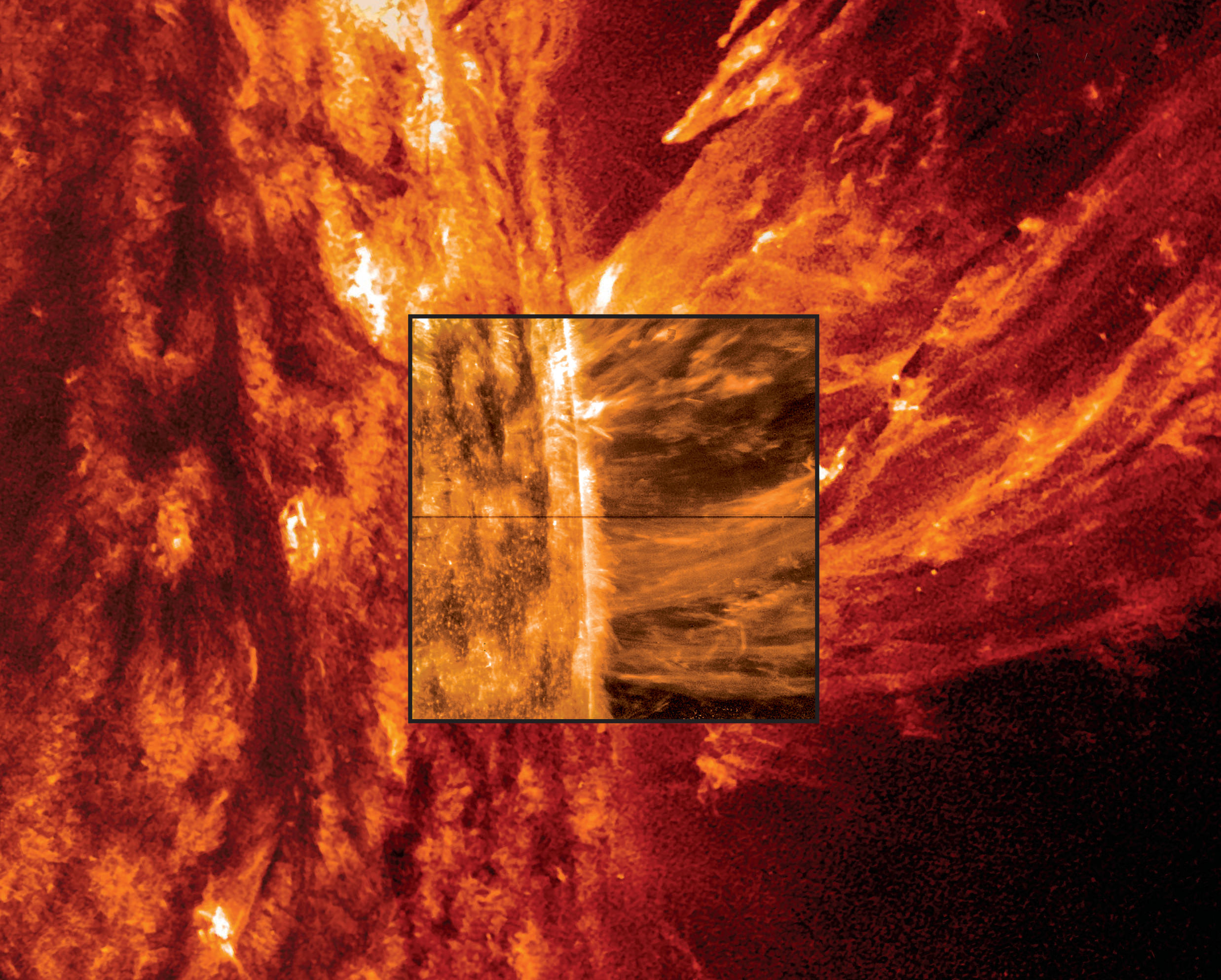
An image of a May 9, 2014 coronal mass ejection from the Sun using data from both the Interface Region Imaging Spectrograph (IRIS) spacecraft and the Solar Dynamics Observatory. Credit: NASA, Lockheed Martin Solar & Astrophysics Laboratory
My, the Sun is a violent place. I mean, we knew that already, but there’s even more evidence for that using new data from a brand-new NASA spacecraft. There’s talk now about tornadoes and jets and even “bombs” swirling amid our Sun’s gassy environment.
A huge set of results from NASA’s Interface Region Imaging Spectrograph (IRIS) spacecraft reveals the true nature of a mysterious transition zone between Sun’s surface and the corona, or atmosphere. Besides the pretty fireworks and videos, these phenomena are telling scientists more about how the Sun moves energy from the center to the outskirts. And, it could tell us more about how stars work in general.
The results are published in five papers yesterday (Oct. 15) in Science magazine. Below, a brief glimpse of what each of these papers revealed about our closest star.
Bombs
This is a heck of a lot of energy packed in here. Raging at temperatures of 200,000 degrees Fahrenheit (111,093 degrees Celsius) are heat “pockets” — also called “bombs” because they release energy quickly. They were found lower in the atmosphere than expected. The paper is here (led by Hardi Peter of the Max Planck Institute for Solar System Research in Gottingen, Germany.)
Tornadoes
It’s a twist! You can see some structures in the chromosphere, just above the Sun’s surface, showing gas spinning like a tornado. They spin around as fast as 12 miles (19 kilometers) a second, which is considered slow-moving on the Sun. The paper is here (led by Bart De Pontieu, the IRIS science lead at Lockheed Martin in California).
High-speed jets
Artist’s impression of the solar wind from the sun (left) interacting with Earth’s magnetosphere (right). Credit: NASA
How does the solar wind — that constant stream of charged particles that sometimes cause aurora on Earth — come to be? IRIS spotted high-speed jets of material moving faster than ever observed, 90 miles (145 kilometers) a second. Since these jets are emerging in spots where the magnetic field is weaker (called coronal holes), scientists suspect this could be a source of the solar wind since the particles are thought to originate from there. The paper is here (led by Hui Tian at the Harvard-Smithsonian Center for Astrophysics in Massachusetts.)
Nanoflares
A solar filament erupts with a coronal mass ejection in this image captured by NASA’s Solar Dynamics Observatory in August 2012. Credit: NASA’s GSFC, SDO AIA Team
Those solar flares the Sun throws off happen when magnetic field lines cross and then snap back into place, flinging particles into space. Nanoflares could do the same thing to heat up the corona, and that’s something else that IRIS is examining. The paper is here (led by Paola Testa, at the Harvard-Smithsonian Center for Astrophysics.)
Structures and more
And here is the transition region in glorious high-definition. Improving on data from the Skylab space station in the 1970s (bottom of video), you can see all sorts of mini-structures on the Sun. The more we learn about these 2,000-mile (3,220-km) objects, the better we’ll understand how heating moves through the Sun. The paper is here (led by Viggo Hansteen, at the University of Oslo in Norway.)
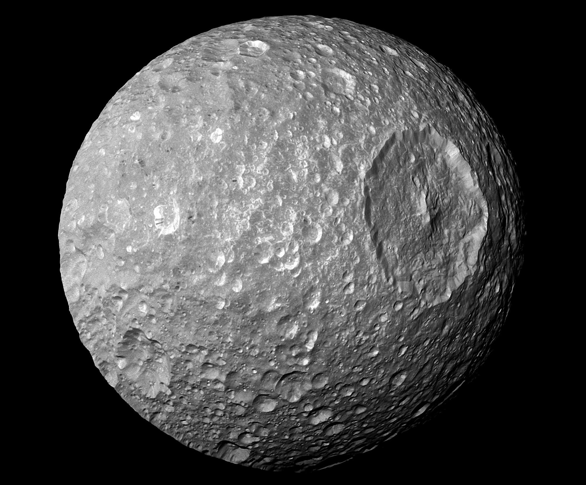
A view of Mimas from the Cassini spacecraft. Credit: NASA/JPL/Space Science Institute
Could there be an ocean hidden somewhere in that Death Star-like picture? This is an image of Mimas, a moon of Saturn, and just yesterday (Oct. 15) newly released data from the Cassini spacecraft suggests there are big liquid reservoirs underneath its surface.
“The amount of the to-and-fro motion indicates that Mimas’ interior is not uniform. These wobbles can be produced if the moon contains a weirdly shaped, rocky core or if a sub-surface ocean exists beneath its icy shell,” said Cornell University in a press release. More flybys with the Cassini spacecraft will be required to learn more about what lies beneath.
You can read more about the study (led by Cornell astronomy research associate Radwan Tajeddine) in Science, where it was published. Below, learn more about other worlds in the Solar System that could host oceans under their surface.
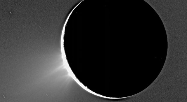
Enceladus
Cassini images of Saturn’s moon Enceladus backlit by the sun show the fountain-like sources of the fine spray of material that towers over the south polar region. This image was taken looking more or less broadside at the “tiger stripe” fractures observed in earlier Enceladus images. It shows discrete plumes of a variety of apparent sizes above the limb (edge) of the moon. This image was acquired on Nov. 27, 2005. Image Credit: NASA/JPL/Space Science Institute
After nearly a decade of speculation, this year the Cassini spacecraft returned gravity data suggesting Enceladus (another moon of Saturn) does have a large subsurface ocean near its south pole, if not a global ocean. If confirmed, that could help explain why scientists see water gushing out of fractures in that area. As this recent paper by Cassini scientists shows, Enceladus is a promising location for habitability.
Titan
A halo of light surrounds Saturn’s moon Titan in this backlit picture, showing its atmosphere. Credit: NASA/JPL/Space Science Institute
By the way, anyone noticed that we still haven’t even left Saturn’s system? Titan is usually high on astrobiology wish lists for researchers because its hydrocarbon chemistry could be precursors to how life evolved. What’s not talked about as much, though, is at least two research findings pointing to evidence of a hidden ocean. Evidence comes from Titan’s tidal flexing from interacting with Saturn — which is 10 times more than what would be expected with a solid core — and the way that it moves on its own axis as well as around Saturn.
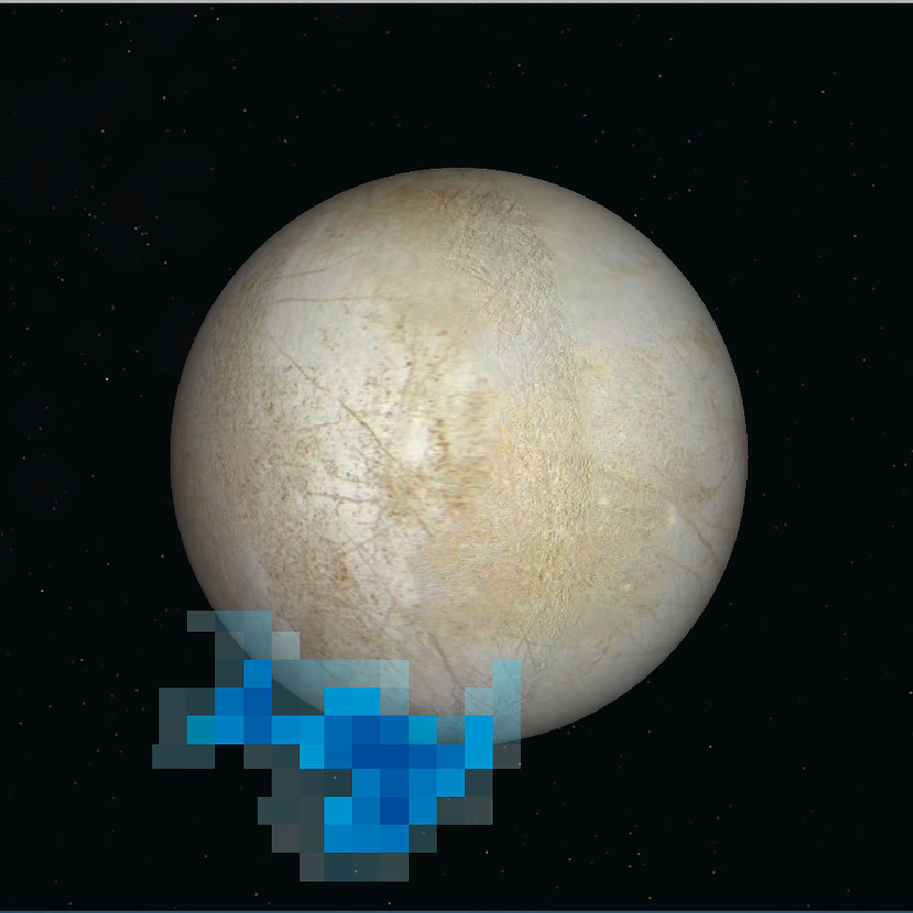
Europa
Rendering showing the location and size of water vapor plumes coming from Europa’s south pole. Credit: NASA/ESA/L. Roth/SWRI/University of Cologne
That Minecraft-looking object floating beside Europa there is a rendering showing where water vapor erupted from the Jovian moon, spotted by the Hubble Space Telescope in 2013. We were lucky enough to have a close-up view of Europa in the 1990s and early 2000s courtesy of NASA’s Galileo spacecraft. What we know for sure is there’s thick ice on Europa. What’s underneath is not known, but there’s long been speculation that it could be a subsurface ocean that may have more water than our own planet.
Io
Jupiter’s volcanic moon Io , imaged by the Galileo spacecraft in 1997. Credit: NASA/JPL/University of Arizona
Still flying around Jupiter here, we now turn our attention to Io — a place that is often remarked upon because of its blotchy appearance as well as all of the volcanoes on its surface. A newer analysis of Galileo data in 2011 — looking at some of the lesser-understood magnetic field data signatures — led one research team to conclude there could be a magma ocean lurking underneath that violence.
Triton
A glimpse of Triton from the Voyager 2 spacecraft, which flew by the Neptunian moon in August 1989. Credit: NASA/JPL
Little is known about Triton because only one spacecraft whizzed by it — Voyager 2, which took a running pass through the Neptune system in August 1989. An Icarus paper two years ago speculated that the world could host a subsurface ocean, but more data is needed. The energy of Neptune (which captured Triton long ago) could have melted its interior through tidal heating, possibly creating water from the ice in its crust.
Charon
Hubble image of Pluto and some of its moons, Charon, Nix and Hydra. Image Credit: NASA, ESA, H. Weaver (JHU/APL), A. Stern (SwRI), and the HST Pluto Companion Search Team
We don’t have any close-up pictures of this moon of Pluto yet, but just wait a year. The New Horizons spacecraft will zoom past Charon and the rest of the system in July 2015. In the meantime, however, findings based on a model came out this summer in Icarus suggesting Charon — despite being so far from the Sun — might have had a subsurface ocean in the past. Or even now. The key is its once eccentric orbit, which would have produced tidal heating while interacting with Pluto. The science team plans to look for cracks that could be indicative of “the structure of the moon’s interior and how easily it deforms, and how its orbit evolved,” stated Alyssa Rhoden of NASA’s Goddard Space Flight Center in Maryland, who led the research.
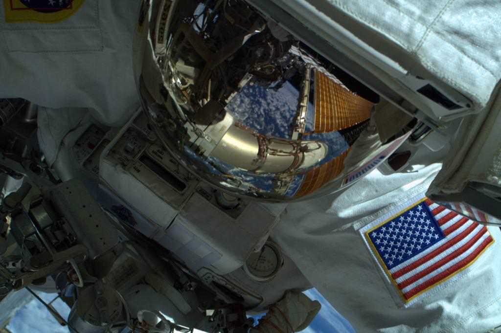
NASA astronaut Reid Wiseman (Expedition 41) captured during an Oct. 15 spacewalk by fellow astronaut Butch Wilmore. Credit: Reid Wiseman / Twitter
What a view! NASA’s Reid Wiseman and Butch Wilmore spacewalked successfully yesterday (Oct. 15) for more than 6.5 hours, replacing a faulty camera as well as a broken power regulator that was reducing the amount of power available on the International Space Station. The astronauts also shifted equipment to get ready for some bigger upgrades on station to prepare for commercial spacecraft arriving in 2017.
Check out the stunning pictures from the spacewalk below.
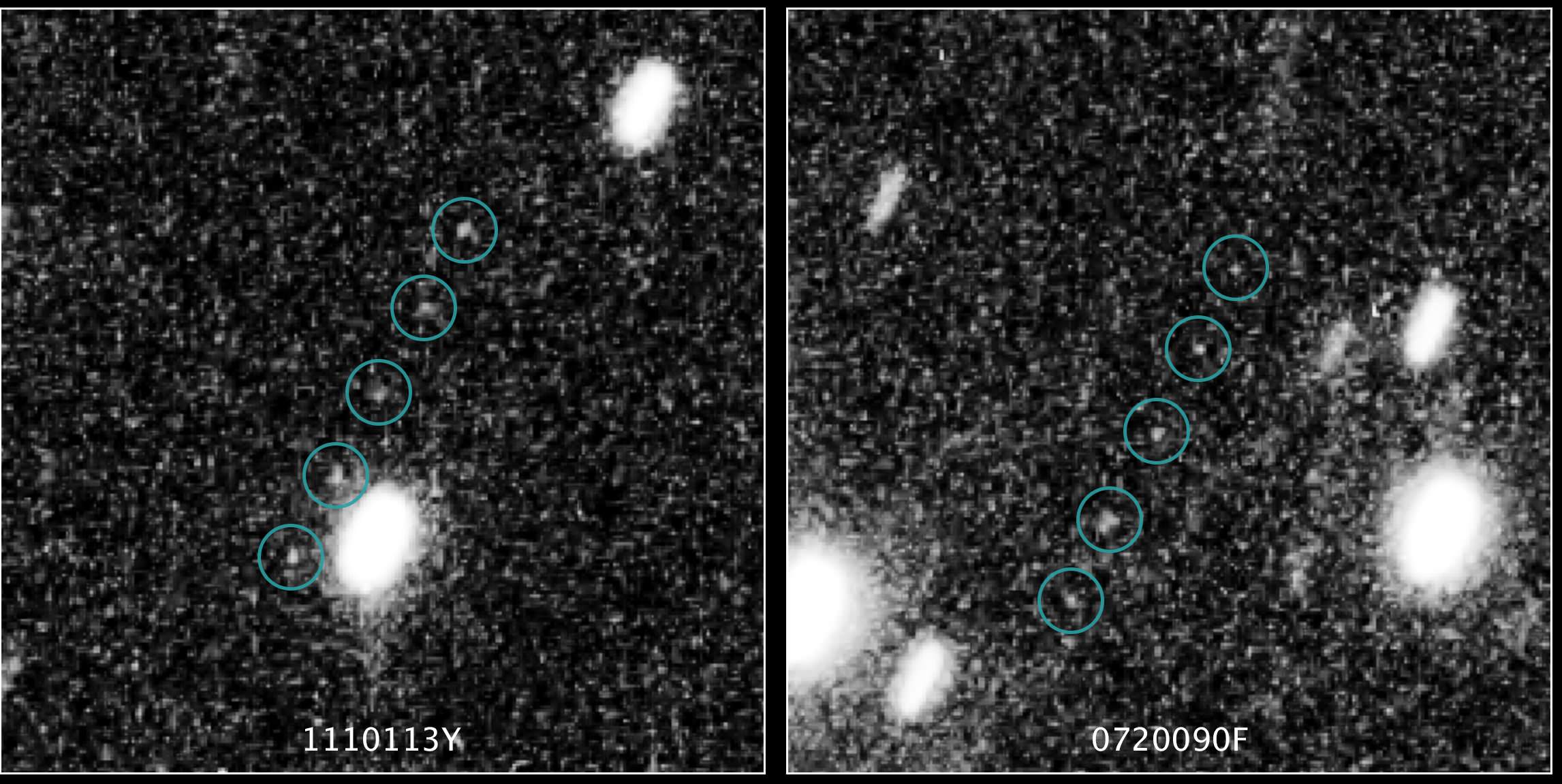
Two potential targets for the New Horizons mission emerge in these Hubble Space Telescope multiple-exposure images. Both are about four billion miles (6.4 billion kilometers) away. NASA, ESA, SwRI, JHU/APL, and the New Horizons KBO Search Team
Where could New Horizons visit after it flies by Pluto next year? NASA’s Hubble Space Telescope is on the case. In a program that pushed the limits of the 24-year-old observatory, Hubble found three potential Kuiper Belt Objects for the spacecraft to visit.
The wrinkle is there is no money approved yet for New Horizons to do an extended mission yet, but team members (including Alex Parker from the Southwest Research Institute, who is quoted from Twitter below) are celebrating the milestone. To them, the most promising target (PT1) is the one on the left of the images you see above. Read more about it below the jump.
The Kuiper Belt is a zone of icy objects about four billion miles (6.4 billion kilometers) from the Sun, considered to be leftovers of the building blocks that put together the Solar System billions of years ago. It’s an area that Pluto itself drifts through from time to time on its elliptical orbit around the Sun. Roughly 1,000 objects there have been cataloged, although many more are believed to exist.
The team used Hubble from June 16 to 26 in a test program to look at 20 sky zones for evidence of KBOs, finding two that had never been spotted before by ground-based telescopes. More searching between July and September revealed one object that is “definitely reachable”, NASA stated, and two others that require more scrutiny.
We estimate that PT1 is several 10s of kilometers across. Here’s what that looks like next to Cape Cod and #Comet67P: pic.twitter.com/IHUx6uymO7
Here is where PT1 lies in relation to the rest of the solar system. The yellow path is New Horizons’ trajectory. pic.twitter.com/4aQDEj8oPZ — Alex Parker (@Alex_Parker) October 15, 2014
Here is a gif of the Hubble Space Telescope discovery images of our New Horizons-targetable Kuiper Belt Object PT1. http://t.co/ifw8I4a8Wz
An important and sobering note: even though New Horizons can reach this Kuiper Belt Object, there is no guarantee of an extended mission. — Alex Parker (@Alex_Parker) October 15, 2014
Each of the three candidates would take a while to reach, as they are all about one billion miles (1.6 billion km) beyond Pluto. They’re also tiny, with two estimated at 34 miles (55 kilometers) across and the third at 15 miles (25 kilometers). This makes them 10 times bigger than the average comet, but only 1-2% the size of small Pluto.
“This was a needle-in-haystack search for the New Horizons team because the elusive KBOs are extremely small, faint, and difficult to pick out against a myriad background of stars in the constellation Sagittarius, which is in the present direction of Pluto,” NASA wrote in a press release.
New Horizons’ team plans to ask for the extended mission in late 2016. Meanwhile, the spacecraft (which has been flying ever outwards since 2006) will finally zoom past its main target of Pluto in July 2015.
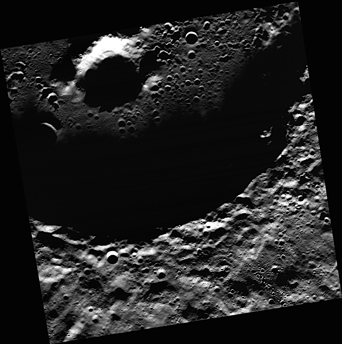
A view of the crater Prokofiev on Mercury. The crater is the largest one on the planet's north pole area to have "radar-bright" material, a probable sign of ice. Credit: NASA/Johns Hopkins University Applied Physics Laboratory/Carnegie Institution of Washington.
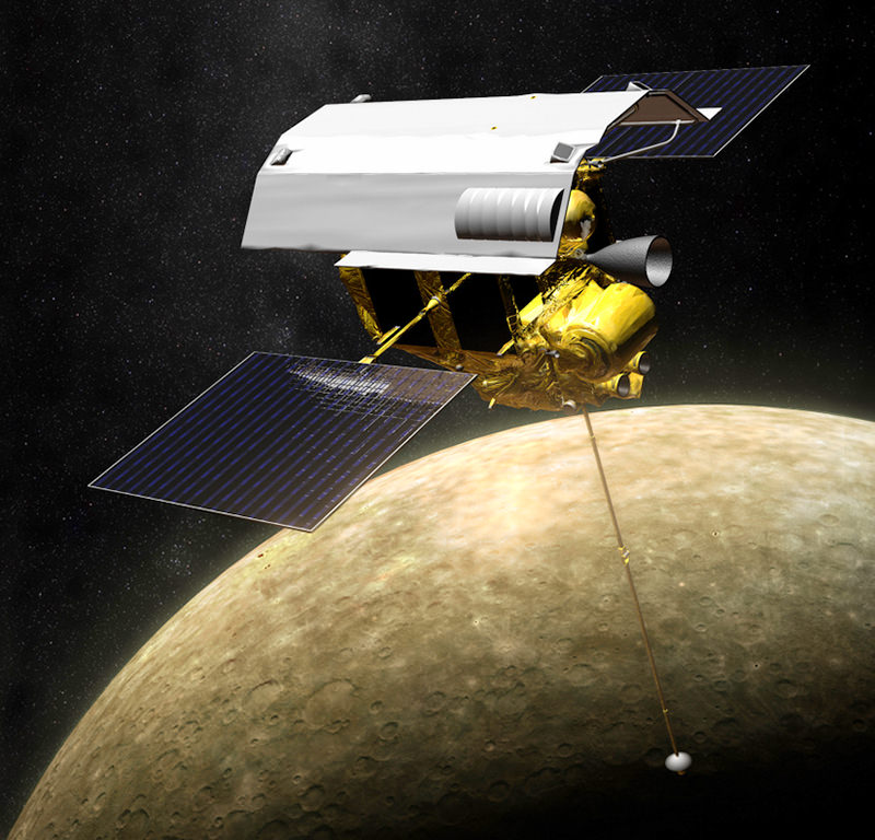
New pictures of water ice at Mercury’s north pole — the first such optical images ever — could help scientists better understand how water came to planets in the rest of the Solar System, including Earth. The image you see above came courtesy of NASA’s MErcury Surface, Space ENvironment, GEochemistry, and Ranging (MESSENGER) spacecraft.
Mercury is a hot planet (it’s the closest one to the Sun), so the only way the ice survives is in deep shadow. This makes it hard to spot unless scientists use some clever techniques. In this case, they examined some scattered light from Prokofiev, the biggest crater in Mercury’s north pole suspected to hold the deposits.
The pictures show that Prokofiev’s surface water ice likely arrived after the craters underneath. And in an intriguing find, there is probably other water ice sitting under dark materials believed to be “frozen organic-rich compounds,” stated the Johns Hopkins University Applied Physics Laboratory.
“This result was a little surprising, because sharp boundaries indicate that the volatile deposits at Mercury’s poles are geologically young, relative to the time scale for lateral mixing by impacts,” stated lead researcher Nancy Chabot, the Instrument Scientist for MESSENGER’s Mercury dual imaging system.
Illustration of MESSENGER in orbit around Mercury (NASA/JPL/APL)
“One of the big questions we’ve been grappling with is ‘When did Mercury’s water ice deposits show up?’ Are they billions of years old, or were they emplaced only recently?”, added Chabot, who is a planetary scientist at the Johns Hopkins University Applied Physics Laboratory in Maryland. “Understanding the age of these deposits has implications for understanding the delivery of water to all the terrestrial planets, including Earth.”
Another intriguing property comes when scientists compare Mercury to the Moon: because the ice looks different on both relatively atmosphere-less bodies, scientists believe the water came more recently to the Moon. But more study is required.
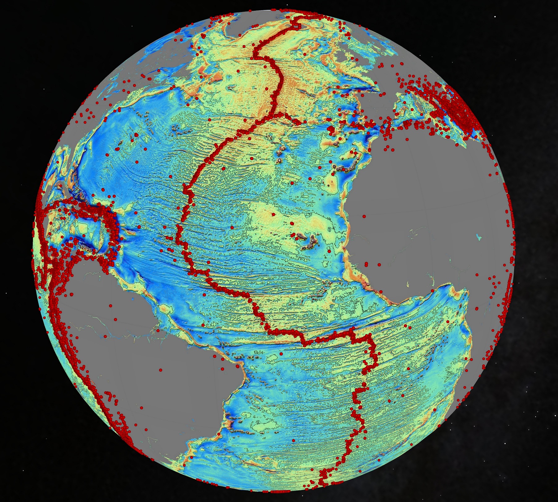
An October 2014 gravity map of the Earth's oceans using data from the European Space Agency's CryoSat mission and the CNES-NASA Jason-1 satellite. Findings include "continental connections" between South American and Africa, and evidence of seafloor spreading in the Gulf of Mexico that took place 150 million years ago. The red dots are volcanoes. Credit: Scripps Institution of Oceanography
Volcanoes! Seafloor spreading! Hidden ridges and mountains! These are the wonders being revealed in new maps of Earth’s sea floor. And no, it didn’t require a deep-sea dive to get there. Instead we got this information from a clever use of gravity (combining the data of two satellites making measurements from orbit.)
The data has caught the attention of Google, which plans to use this data for its upcoming ocean maps release. Scientists also say the information will tell us more about the 80% of the ocean floor that is either unexamined or obscured by thick sand.
So here’s where the data came from. The Scripps Institution of Oceanography combined information from two satellites — the European Space Agency’s ongoing CryoSat mission and the now defunct Jason-1 satellite from NASA and the French space agency CNES, which was decommissioned in 2013 after nearly 12 years of operations.
CryoSat is designed to map the thickness of ice using a radar altimeter (which is a clue to the effects of climate change). But this altimeter can be used all over the world, including to look at how high the sea floor is. Jason-1, for its part, was told to look at the Earth’s gravity field in the last year of its mission. And what a world pops out when this data is used.
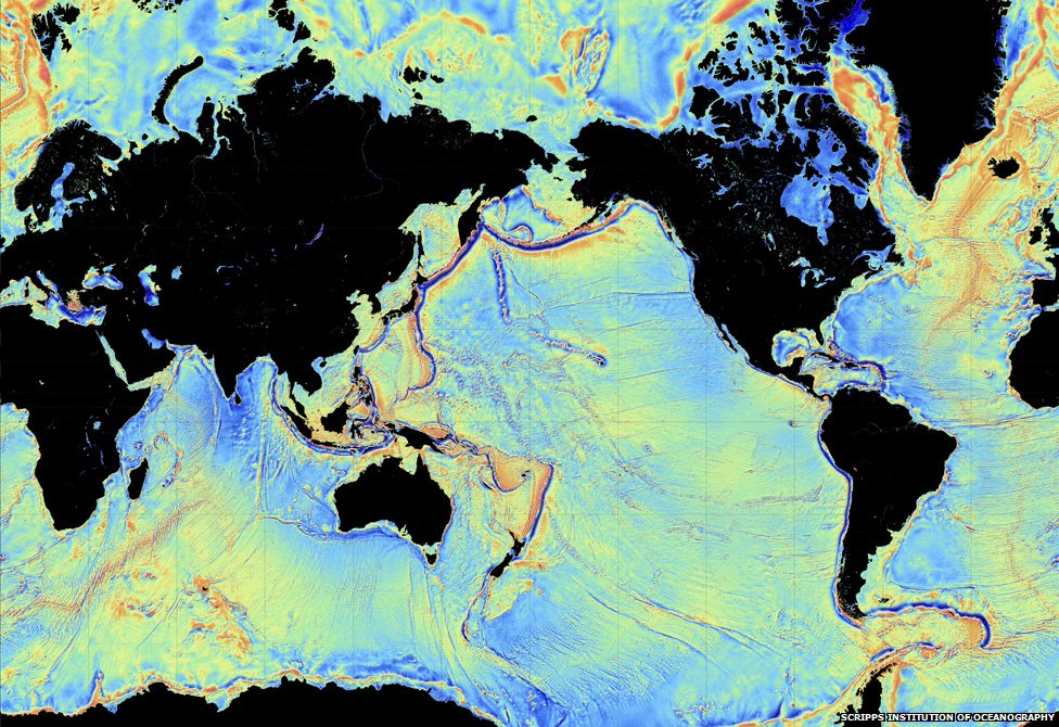
A 2014 view of the Earth’s sea floor using data from the European Space Agency’s CryoSat mission and the CNES-NASA Jason-1 satellite. Credit: Scripps Institution of Oceanography
“The effect of the slight increase in gravity caused by the mass of rock in an undersea mountain is to attract a mound of water several meters high over the seamount. Deep ocean trenches have the reverse effect,” ESA wrote in a statement. “These features can only be detected by using radar altimetry from space.”
Some of the new findings include finding new bridges between Africa and South America and uncovering seafloor spreading that happened in the Gulf of Mexico 150 million years ago. Results based on the study, led by Scripps’ David Sandwell, recently appeared in the journal Science.
Long-time readers of Universe Today may also recall a gravity map from ESA’s Gravity Field and Steady-State Ocean Circulation Explorer (GOCE), which revealed Earth’s gravity as a lumpy potato shape in 2011.
Artist's conception of one of the Solar TErrestrial RElations Observatory (STEREO) spacecraft. Credit: NASA
A NASA spacecraft has been out of radio contact for about two weeks, but the agency is still holding out hopes for a rescue. One of the STEREO (Solar TErrestrial RElations Observatory) spacecraft stopped phoning home to Earth on Oct. 1 “immediately after a planned reset of the spacecraft”, NASA said in an update last week.
If the STEREO-Behind spacecraft can’t be recovered, this could cause a data gap in the mission next year — which is unique because it looks at the far side of the Sun. On the website, NASA didn’t say how badly solar weather forecasts are affected, but in other materials they have said both STEREO spacecraft are a crucial part of this work.
STEREO’s pair of satellites (STEREO-Ahead and STEREO-Behind) aim to better map Sun eruptions (known as “coronal mass ejections”) whose charged particles can disrupt satellite communications during solar storms. The mission has been ongoing since 2006 and they’ve viewed the far side of the Sun since 2011. What caused one of them to stop talking to us is unknown, but NASA said recovery attempts are ongoing.
The satellites’ orbits around the Sun are similar to the Earth’s, but one circles a bit faster and the other a bit slower. Next year, geometry (a solar conjunction) means the Sun will block our view of one of the spacecraft at a time. As NASA explained in a July update, “radio receivers on Earth will not be able to distinguish STEREO’s signal from the sun’s radiation.”
This is affecting the mission in two ways. First, there is a period where the antennas on the spacecraft must be repositioned to avoid getting cooked by the Sun. Some data will flow, but it will be in lower resolution. STEREO-Ahead entered this period on Aug. 20, and STEREO-Behind was supposed to send high-resolution data until Dec. 1.
Then there’s a time when each spacecraft will be completely blocked by the Sun. STEREO-Behind was supposed to enter this period from Jan. 22 to March 23, 2015, with its twin still collecting data at this time. But then will come a period where STEREO-Ahead will be out of contact: March 24 to July 7, 2015. If STEREO-Behind can’t fill in for STEREO-Ahead at this time as planned, a data gap could loom.
Lower-resolution data is then expected from STEREO until 2016, when the geometry means the spacecraft can safely reposition their antennas. While these aren’t the only sun-gazing spacecraft — real-time data is still flowing from the Solar Dynamics Observatory (SDO) and the Solar and Heliospheric Observatory (SOHO) — NASA has said that the lower data rate and losing contact with one STEREO spacecraft next year will be difficult for solar forecasting.
“Lack of STEREO observations used in NASA research models will severely limit the forecasting of solar storms throughout the solar system,” the agency said in a July Q&A about the 2015 data losses.
ISS-RapidScat instrument, shown in this artist's rendering, was launched to the International Space Station aboard the SpaceX CRS-4 mission on Sept. 21, 2014 and attached at ESA’s Columbus module. It will measure ocean surface wind speed and direction and help improve weather forecasts, including hurricane monitoring. Credit: NASA/JPL-Caltech/Johnson Space Center.
NASA inaugurated a new era of research for the International Space Station (ISS) as an Earth observation platform following the successful installation and activation of the ISS-RapidScat science instrument on the outposts exterior at Europe’s Columbus module.
The ISS Rapid Scatterometer, or ISS-RapidScat, is NASA’s first research payload aimed at conducting near global Earth science from the station’s exterior and will be augmented with others in coming years.
RapidScat is designed to monitor ocean winds for climate research, weather predictions, and hurricane monitoring.
The 1280 pound (580 kilogram) experimental instrument is already collecting its first science data following its recent power-on and activation at the station.
“Its antenna began spinning and it started transmitting and receiving its first winds data on Oct.1,” according to a NASA statement.
The first image from RapidScat was released by NASA on Oct. 6, shown below, and depicts preliminary measurements of global ocean near-surface wind speeds and directions.
Launched Sept. 21, 2014, to the International Space Station, NASA’s newest Earth-observing mission, the International Space Station-RapidScat scatterometer to measure global ocean near-surface wind speeds and directions, has returned its first preliminary images. Credit: NASA-JPL/Caltech
The $26 million remote sensing instrument uses radar pulses to observe the speed and direction of winds over the ocean for the improvement of weather forecasting.
“Most satellite missions require weeks or even months to produce data of the quality that we seem to be getting from the first few days of RapidScat,” said RapidScat Project Scientist Ernesto Rodriguez of NASA’s Jet Propulsion Laboratory, Pasadena, California, which built and manages the mission.
“We have been very lucky that within the first days of operations we have already been able to observe a developing tropical cyclone.
“The quality of these data reflect the level of testing and preparation that the team has put in prior to launch,” Rodriguez said in a NASA statement. “It also reflects the quality of the spare QuikScat hardware from which RapidScat was partially assembled.”
RapidScat, payload was hauled up to the station as part of the science cargo launched aboard the commercial SpaceX Dragon CRS-4 cargo resupply mission that thundered to space on the company’s Falcon 9 rocket from Space Launch Complex-40 at Cape Canaveral Air Force Station in Florida on Sept. 21.
Dragon was successfully berthed at the Earth-facing port on the station’s Harmony module on Sept 23, as detailed here.
It was robotically assembled and attached to the exterior of the station’s Columbus module using the station’s robotic arm and DEXTRE manipulator over a two day period on Sept 29 and 30.
Ground controllers at Johnson Space Center intricately maneuvered DEXTRE to pluck RapidScat and its nadir adapter from the unpressurized trunk section of the Dragon cargo ship and attached it to a vacant external mounting platform on the Columbus module holding mechanical and electrical connections.
Fascinating: #Canadarm & Dextre installed the #RapidScat Experiment on Columbus! @ISS_Research @NASAJPL @csa_asc. Credit: ESA/NASA/Alexander Gerst
The nadir adapter orients the instrument to point at Earth.
The couch sized instrument and adapter together measure about 49 x 46 x 83 inches (124 x 117 x 211 centimeters).
Engineers are in the midst of a two week check out process that is proceeding normally so far. Another two weeks of calibration work will follow.
Thereafter RapidScat will begin a mission expected to last at least two years, said Steve Volz, associate director for flight programs in the Earth Science Division, NASA Headquarters, Washington, at a prelaunch media briefing at the Kennedy Space Center.
RapidScat is the forerunner of at least five more Earth science observing instruments that will be added to the station by the end of the decade, Volz explained.
The second Earth science instrument, dubbed CATS, could be added by year’s end.
The Cloud-Aerosol Transport System (CATS) is a laser instrument that will measure clouds and the location and distribution of pollution, dust, smoke, and other particulates in the atmosphere.
CATS is slated to launch on the next SpaceX resupply mission, CRS-5, currently targeted to launch from Cape Canaveral, FL, on Dec. 9.
A SpaceX Falcon 9 rocket carrying a Dragon cargo capsule packed with science experiments and station supplies blasts off from Space Launch Complex 40 at Cape Canaveral Air Force Station, Florida, at 1:52 a.m. EDT on Sept. 21, 2014, bound for the ISS. Credit: Ken Kremer/kenkremer.com
This has been a banner year for NASA’s Earth science missions. At least five missions will be launched to space within a 12 month period, the most new Earth-observing mission launches in one year in more than a decade.
ISS-RapidScat is the third of five NASA Earth science missions scheduled to launch over a year.
NASA managers show installed location of ISS-RapidScat instrument on the ESA Columbus module on an ISS scale model at the Kennedy Space Center press site during launch period for the SpaceX CRS-4 Dragon cargo mission. Posing are Steve Volz, associate director for flight programs in the Earth Science Division, NASA Headquarters, Washington, and Howard Eisen, RapidScat Project Manager. Credit: Ken Kremer – kenkremer.com
Stay tuned here for Ken’s continuing Earth and Planetary science and human spaceflight news.
Learn more about Commercial Space Taxis, Orion and NASA Human and Robotic Spaceflight at Ken’s upcoming presentations:
Oct 14: “What’s the Future of America’s Human Spaceflight Program with Orion and Commercial Astronaut Taxis” & “Antares/Cygnus ISS Rocket Launches from Virginia”; Princeton University, Amateur Astronomers Assoc of Princeton (AAAP), Princeton, NJ, 7:30 PM
Oct 23/24: “Antares/Cygnus ISS Rocket Launch from Virginia”; Rodeway Inn, Chincoteague, VA
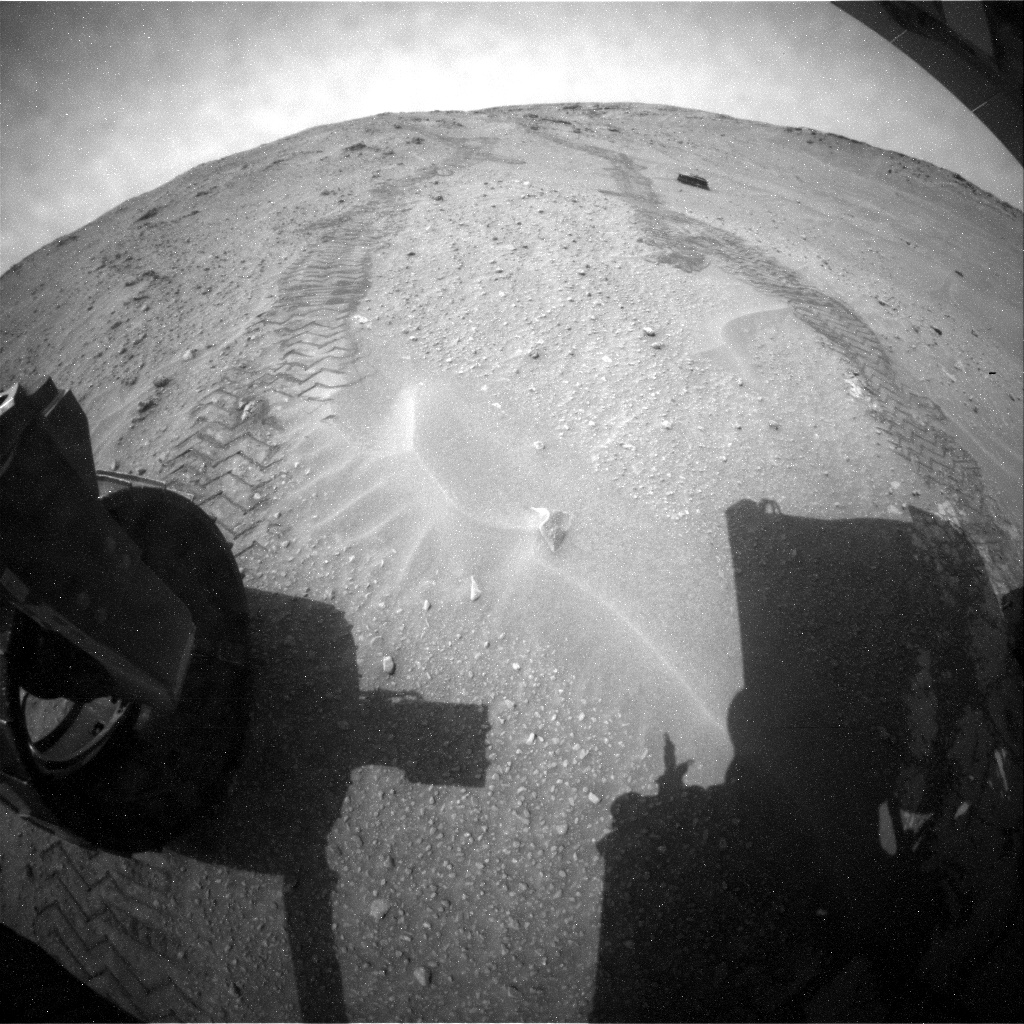
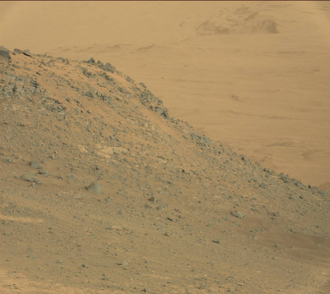
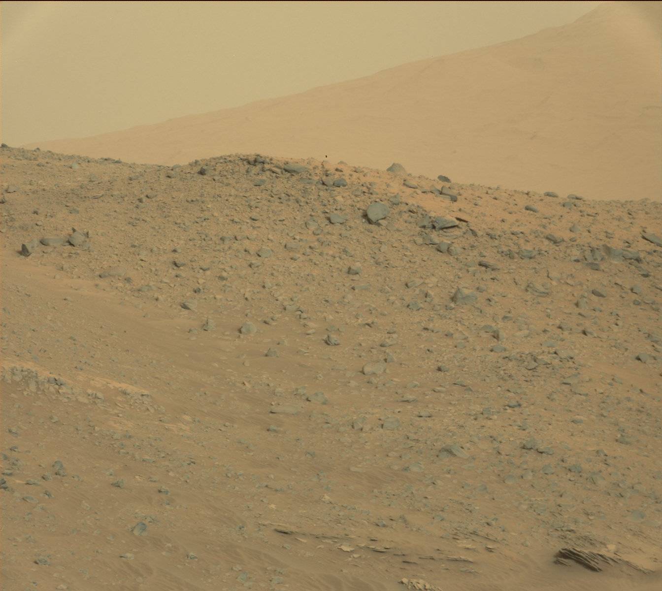
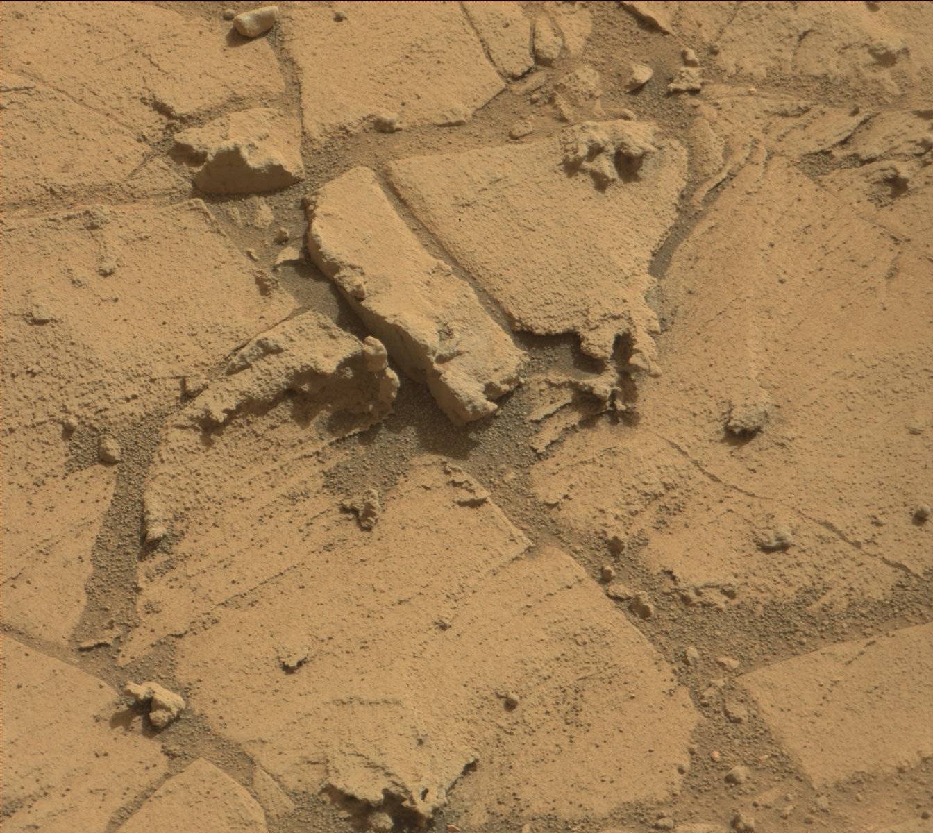
Rover tracks and Martian sand as seen from the rear hazcam of NASA's Curiosity rover. Credit: NASA/JPL-Caltech
After a couple of years of racing towards Mount Sharp (Aeolis Mons), now it’s time for the Curiosity rover to get a better look at its Martian surroundings. The rover has reached its stated science destination and mission planners say now is the time to stop the driving and get deep into the science.
NASA is on the hunt for signs of habitability on the Red Planet, and officials hope that the layers of this big mountain will yield a wealth of information on Martian history.
“This first look at rocks we believe to underlie Mount Sharp is exciting because it will begin to form a picture of the environment at the time the mountain formed, and what led to its growth,” stated Ashwin Vasavada, Curiosity’s deputy project scientist in a press release from late September.
As Curiosity drills and analyzes rocks at its feet, it continues to send back stunning pictures of its surroundings. Check out a sample from this week below.
Mars Curiosity peers over a craggy ridge on Oct. 7, 2014 (Sol 771). Credit: NASA/JPL-Caltech/MSSSMartian hills beckon in this photo from the Curiosity rover taken Oct. 7, 2014, on Sol 771. Credit: NASA/JPL-Caltech/MSSSClose-up of a brush instrument on the Mars Curiosity rover on Oct. 3 (Sol 767). Credit: NASA/JPL-Caltech/MSSSCracked terrain underfoot seen by the Martian Curiosity rover on Oct. 7, 2014 (Sol 771). Credit: NASA/JPL-Caltech/MSSS
Photo of a spacewalker at work on the International Space Station on Oct. 7, 2014. "I don't have words to describe what we did today, but this photo gives a pretty good impression!" wrote European Space Agency astronaut (and spacewalk participant) Alexander Gerst on Twitter as a caption to this photo. Credit: Alexander Gerst / Twitter
What happens when you send two prolific social media astronauts out on a spacewalk? The best photos ever. Reid Wiseman (NASA) and Alexander Gerst (European Space Agency) both participated in their first extra-vehicular activity yesterday, and sent back amazing pictures of what the view looked like outside their visors.
Their comments are also fun: “reasonably INSANE” and “learning to fly” are among the phrases they put on Twitter, which you can see in the photo gallery below. The spacewalkers accomplished the major task of yesterday’s spacewalk, placing a failed International Space Station pump module in a permanent location, and doing a couple of minor maintenance tasks.
And here’s a bonus for those who scrolled to the end of this post — the first Vine video posted real-time during a spacewalk! This comes courtesy of NASA’s account. Click on the video to access the audio, which is Reid Wiseman exclaiming on the view over southern South America.