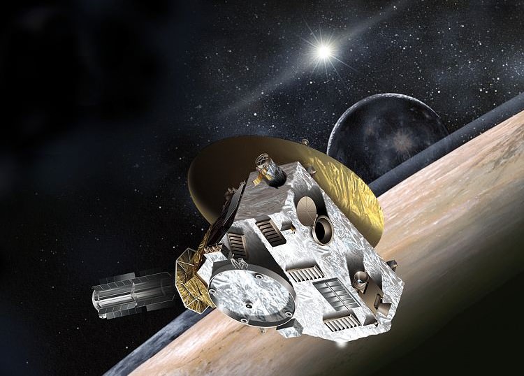
Artist's impression of the New Horizons spacecraft. Image Credit: NASA
After almost nine years on the road, New Horizons is in what NASA calls “Pluto-space”! Earlier today (July 7), the spacecraft Twitter account announced New Horizons is now 29.8 Earth-sun distances (astronomical units) away from the Sun, putting it within the boundaries of Pluto’s eccentric orbit — exciting, since Pluto is the primary science target.
“Didn’t get the word? We’re farther out than Pluto’s minimum distance to the Sun. We’re in ‘Pluto-space’ now!” tweeted the New Horizons account. We’ve included some of the best Pluto pictures below, to date, to celebrate.
And while many are focused on the Pluto encounter itself, NASA is already planning for what to do next for the spacecraft. In mid-June, we reported that the Hubble Space Telescope was doing a test search for icy Kuiper Belt objects that New Horizons could possibly fly to next.
That test search was successful enough, with two objects found, that Hubble is now doing a full-blown investigation, according to an announcement last week. Hubble will begin that work in July and conclude observations in August. New Horizons is expected to fly by Pluto and its moons in July 2015.
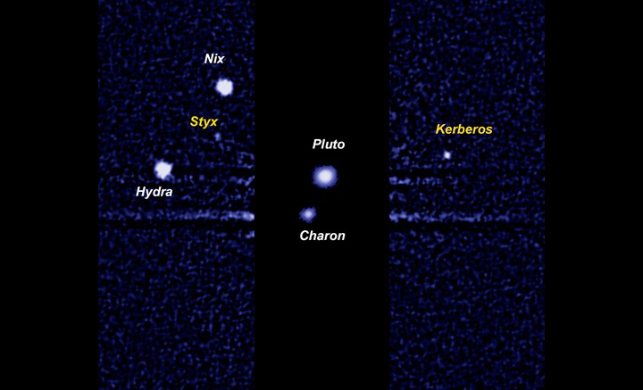
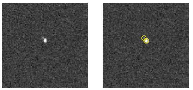
Pluto’s surface as viewed from the Hubble Space Telescope in several pictures taken in 2002 and 2003. Though the telescope is a powerful tool, the dwarf planet is so small that it is difficult to resolve its surface. Astronomers noted a bright spot (180 degrees) with an unusual abundance of carbon monoxide frost. Credit: NASAPluto and its moons, most of which were discovered while New Horizons was in development and en route. Charon was found in 1978, Nix and Hydra in 2005, Kerberos in 2011 and Styx in 2012. The New Horizons mission launched in 2006. Picture taken by the Hubble Space Telescope. Credit: NASAPluto and moons Charon, Hydra and Nix (left) compared to the dwarf planet Eris and its moon Dysnomia (right). This picture was taken before Kerberos and Styx were discovered in 2011 and 2012, respectively. Credit: International Astronomical UnionPluto appears as a faint white dot (see arrow) in this image taken by New Horizons in September 2006, nine months after launch. Credit: NASA/Johns Hopkins University Applied Physics Laboratory/Southwest Research InstitutePluto and Charon are visible in this 2013 image from New Horizons’ LOng Range Reconnaissance Imager (LORRI). It was the first image from the spacecraft showing Charon separated from Pluto. Credit: NASA/Johns Hopkins University Applied Physics Laboratory/Southwest Research Institute
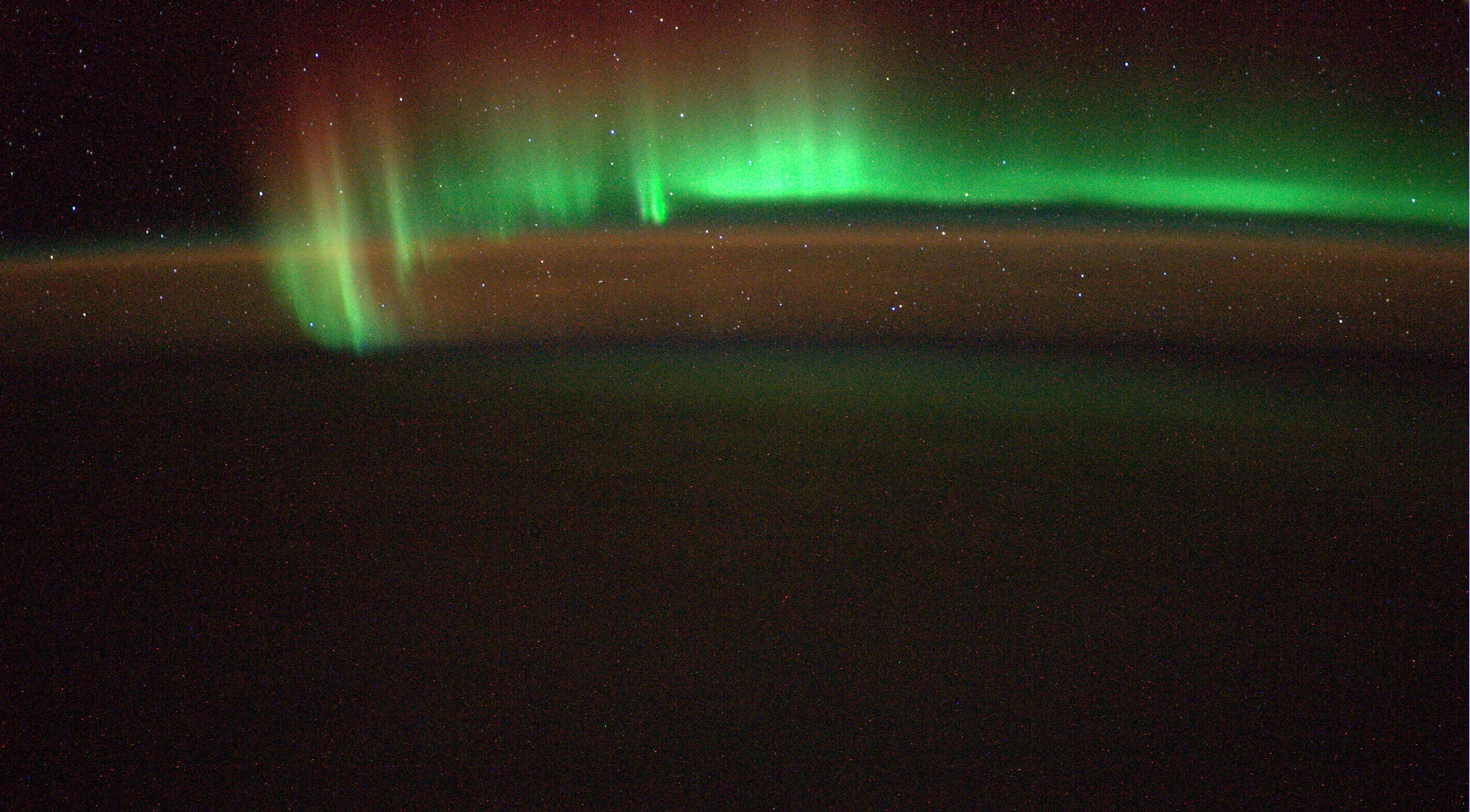
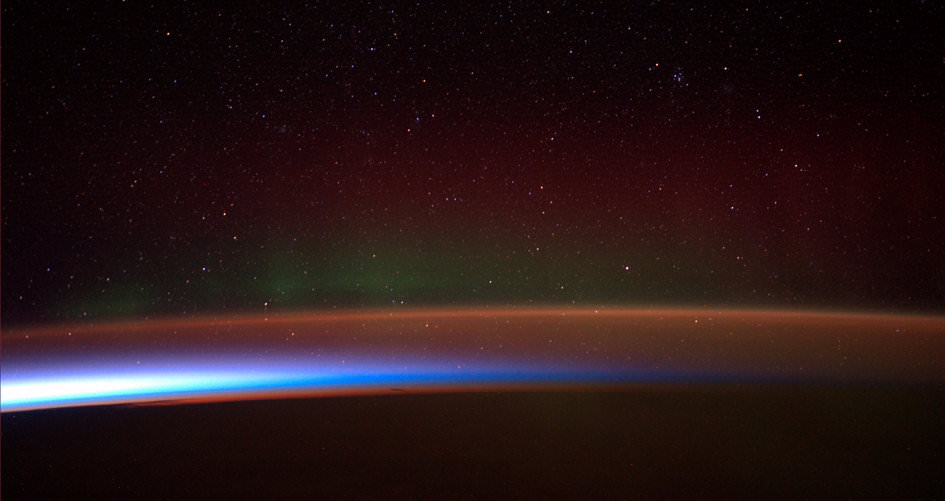
“Saw a beautiful Southern Light last night. I so wish you could see this with your own eyes!” Image taken from the International Space Station (ISS) on 5 July 2014. Credit: ESA/Alexander Gerst
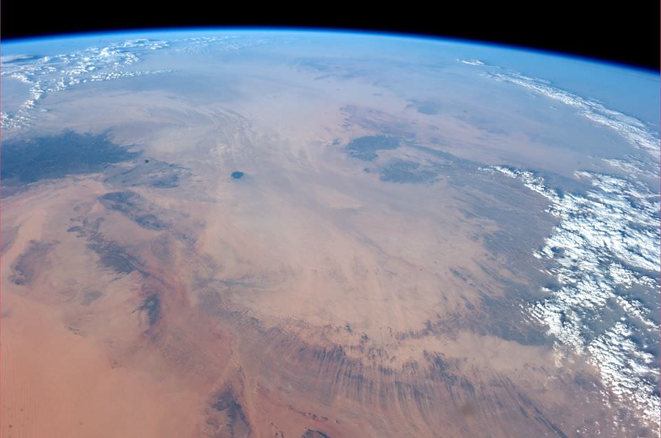
Spectacular snapshots of the Southern Lights, Shooting Stars, the Sahara Desert and much more are streaming back from space to Earth courtesy of Alexander Gerst, ESA’s German astronaut currently serving aboard the International Space Station (ISS).
See a gallery of Alex’s stunning space-based views (sagenhafte Weltraum bilder) collected herein – starting with the auroral fireworks seen from space – above. It coincides with the Earth-based fireworks of America’s 4th of July Independence Day weekend celebrations and spectacular Noctilucent Clouds (NLCs) wafting over the Northern Hemisphere. NLC gallery here.
“Saw a beautiful Southern Light last night. I so wish you could see this with your own eyes!” Alex tweeted in English.
Gerst is posting his Earth & space imagery from the ISS on a variety of social media including Twitter, Facebook, Google+ and his ESA astronaut blog bilingually in English and German.
Another new snapshot of Earth’s “beautiful Southern Lights” taken from the ISS on 5 July 2014. Credit: ESA/Alexander Gerst
“Habe gestern ein wunderschönes Südlicht gesehen. Ich wünschte ihr könntet das mit eigenen Augen sehen!” Alex tweeted in German.
Check out Alexander Gerst’s stunning 1st timelapse video from the ISS:
Video Caption: ESA astronaut Alexander Gerst’s first timelapse from the International Space Station features the first shooting star that he saw from above. Made by stitching together over 250 images this short clip shows the beauty of our world and the space around it. Published on July 5, 2014. Credit: ESA/Alexander Gerst
Gerst launched to the ISS on his rookie space flight on May 28, 2014 aboard a Russian Soyuz capsule along with Russian cosmonaut Maxim Suraev and NASA astronaut Reid Wiseman.
ISS Expedition 40 patch
The trio are members of Expeditions 40 and 41 and joined three more station flyers already aboard – cosmonauts Alexander Skvortsov & Oleg Artemyev and astronaut Steve Swanson – to bring the station crew complement to six.
Alex will spend six months on the ISS for ESA’s Blue Dot mission. He is Germany’s third astronaut to visit the ISS. He is trained as a geophysicist and a volcanologist.
Gerst also has practiced and honed another talent – space barber! He shaved the heads of his two American crew mates – to match his bald head – after winning a friendly wager with them when Germany beat the US in a 2014 FIFA World Cup match on June 26.
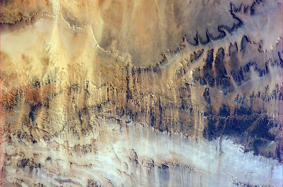
Here’s several of Alexander Gerst’s newest views of the Sahara Desert and more.
“Even from space, the Sahara looks dry! Sogar vom Weltraum aus, sieht die Sahara trocken aus!” Taken from the ISS on 6 July 2014. Credit: ESA/Alexander Gerst“Harsh land. Windswept valleys in northern Africa. Hartes Land. Windgefraeste Taeler in Nordafrika.” Taken from the ISS on 6 July 2014. Credit: ESA/Alexander Gerst“Sometimes our atmosphere looks incredibly complex and three-dimensional, sometimes you don’t even see it. Manchmal schaut unsere Atmosphäre unglaublich Komplex und dreidimensional aus, manchmal fast unsichtbar.” Taken from the ISS on 5 July 2014. Credit: ESA/Alexander GerstAntarctic aurora. The Antarctic aurora, photographed by ESA astronaut Alexander Gerst and posted on social media with the comment: “Antarctic Aurora fleeing from sunrise. I have rarely seen something more magical in my life!” Credits: ESA/NASA/Alexander Gerst
Stay tuned here for Ken’s continuing ISS, OCO-2, GPM, Curiosity, Opportunity, Orion, SpaceX, Boeing, Orbital Sciences, MAVEN, MOM, Mars and more Earth & Planetary science and human spaceflight news.
Learn more about Orbital Sciences Antares ISS launch on July 11 from NASA Wallops, VA, and more about SpaceX, Boeing, commercial space, NASA’s Mars missions and more at Ken’s upcoming presentations.
July 10/11: “Antares/Cygnus ISS Launch from Virginia” & “Space mission updates”; Rodeway Inn, Chincoteague, VA, evening
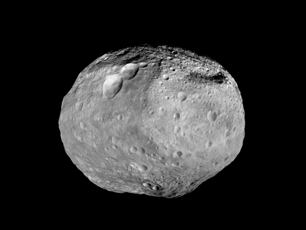
The asteroid Vesta as seen by the Dawn spacecraft. Credit: NASA/JPL-Caltech/UCAL/MPS/DLR/IDA
While “dark materials” may leave some of us thinking about a certain Philip Pullman book series, on the asteroid Vesta its presence belies something equally exotic: old smaller asteroid impacts on its surface.
The dark stuff on the lighter surface has puzzled researchers since it was discovered in 2011 (and has been brought up in other studies), but a new team says it has found that serpentine is among the components. Because that mineral can’t survive temperatures that are more than 400 degrees Celsius (752 degrees Fahrenheit), this means that scenarios such as volcanic eruptions can’t have caused it. This leaves only smaller asteroids, the team says.
“These meteorites are regarded as fragments of carbon-rich asteroids. The impacts must have been comparatively slow, because an asteroid crashing at high speeds would have produced temperatures too high to sustain serpentine,” the Max Planck Institute for Solar System Research stated.
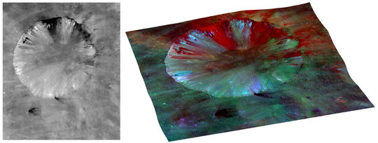
Image of the crater Numisia on Vesta, where researchers found the spectral signature of serpentine. Picture taken by NASA’s Dawn spacecraft. Credit: NASA/JPL-Caltech/UCLA/MPS/DLR/IDA
“In a previous study, scientists from the MPS had calculated how dark material would be distributed on Vesta as a result of a low-speed oblique impact. Their results are consistent with the distribution of dark material on the edge of one of the two large impact basins in the southern hemisphere.”
The results came from analyzing images the NASA Dawn spacecraft took of Vesta between July 2011 and September 2012. The researchers recalibrated the data and also backed up their results by examining serpentine in laboratory conditions.
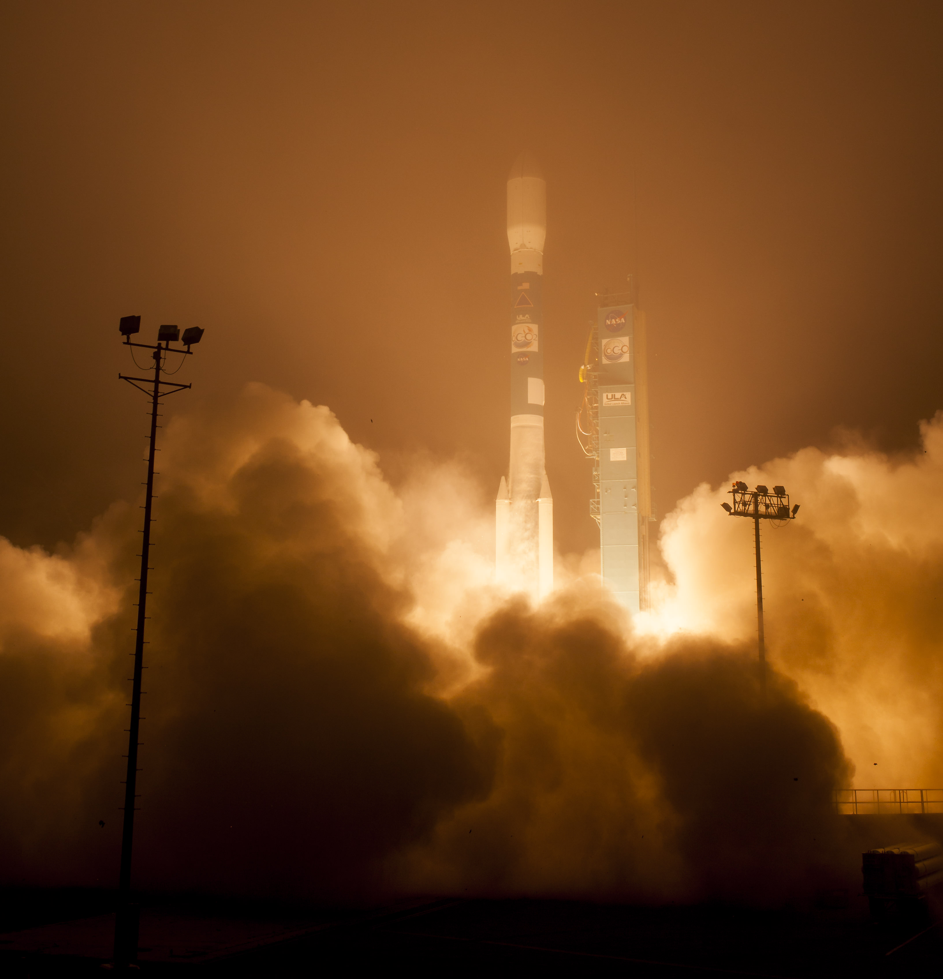
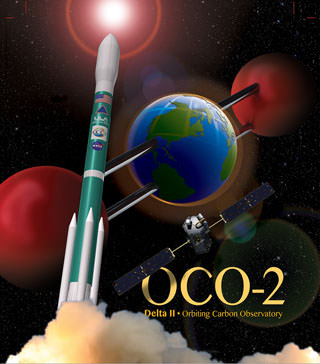
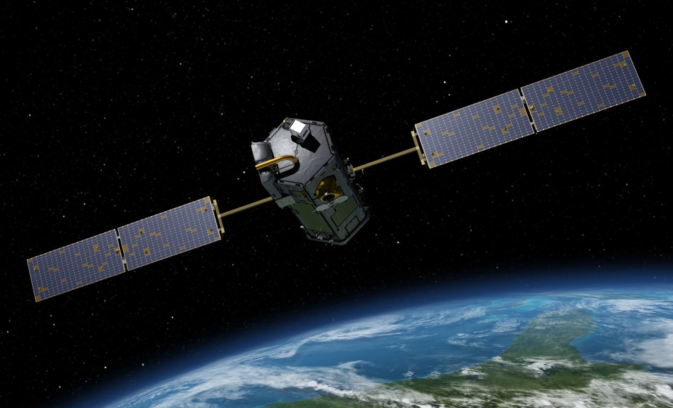
The Orbiting Carbon Observatory-2, NASA's first mission dedicated to studying carbon dioxide in Earth's atmosphere, lifts off from Vandenberg Air Force Base, California, at 2:56 a.m. Pacific Time, July 2, 2014 on a Delta II rocket. The two-year mission will help scientists unravel key mysteries about carbon dioxide. Credit: NASA/Bill Ingalls
The Orbiting Carbon Observatory-2, NASA’s first mission dedicated to studying carbon dioxide in Earth’s atmosphere, lifts off from Vandenberg Air Force Base, California, at 2:56 a.m. Pacific Time, July 2, 2014 on a Delta II rocket. The two-year mission will help scientists unravel key mysteries about carbon dioxide. Credit: NASA/Bill Ingalls
Story updated[/caption]
Following a nearly three-year long hiatus, the workhorse Delta II rocket successfully launched NASA’s first spacecraft dedicated to watching Earth breathe by studying Earth’s atmospheric carbon dioxide (CO2) – the leading human-produced greenhouse gas and the principal human-produced driver of climate change.
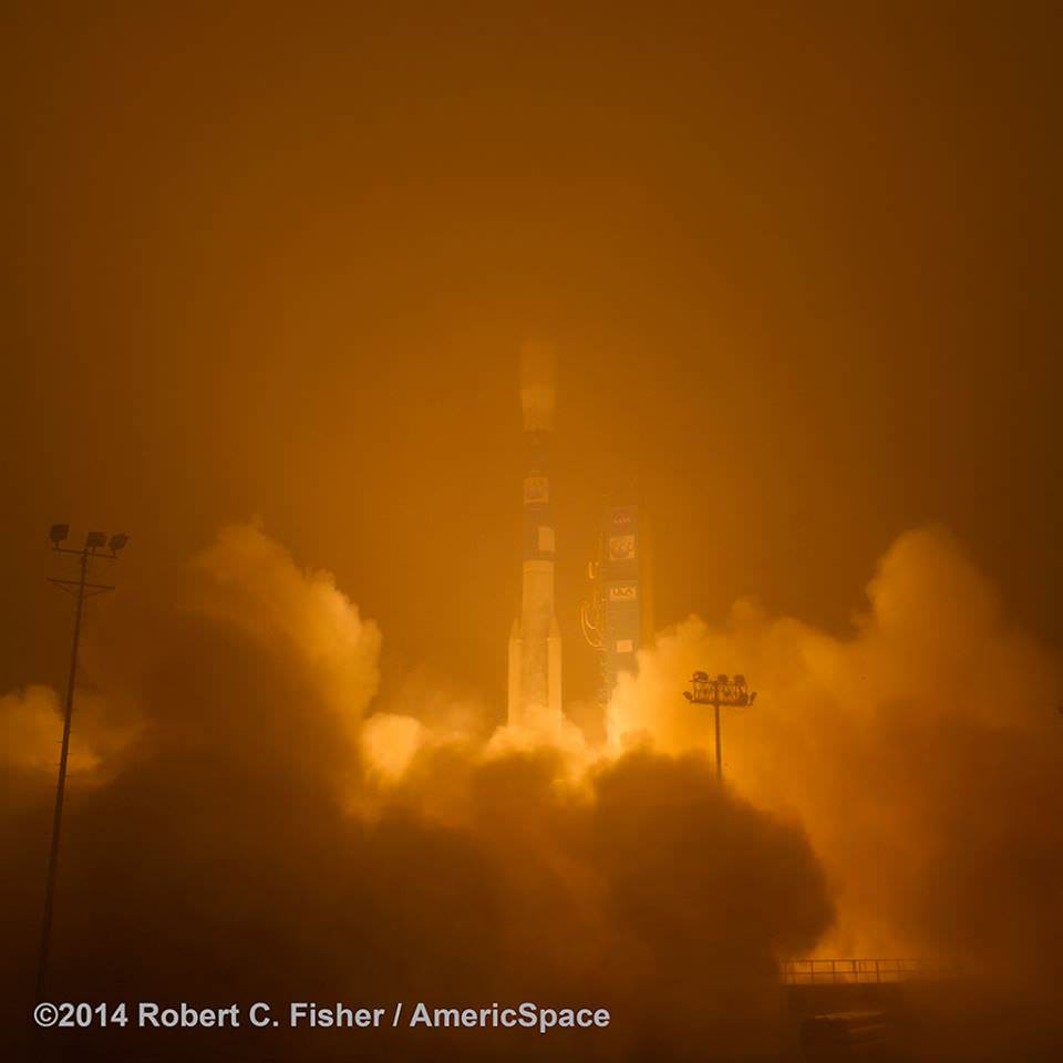
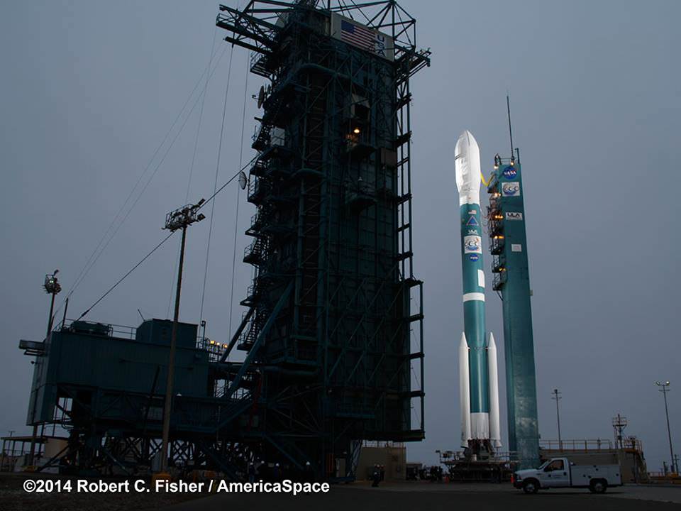
The Orbiting Carbon Observatory-2 (OCO-2) raced to orbit earlier this morning, during a spectacular nighttime blastoff at 2:56 a.m. PDT (5:56 a.m. EDT), Tuesday, July 2, 2014, from Vandenberg Air Force Base, California, atop a United Launch Alliance Delta II rocket.
The flawless launch marked the ‘return to flight’ of the venerable Delta II and was broadcast live on NASA TV.
Blastoff of NASA’s Orbiting Carbon Observatory-2 dedicated to studying carbon dioxide in Earth’s atmosphere, from Vandenberg Air Force Base, California, at 2:56 a.m. Pacific Time, July 2, 2014. Credit: Robert Fisher/America/Space
A camera mounted on the Delta II’s second stage captured a breathtaking live view of the OCO-2 spacecraft during separation from the upper stage, which propelled it into an initial 429-mile (690-kilometer) orbit.
The life giving solar arrays were unfurled soon thereafter and NASA reports that the observatory is in excellent health.
“Climate change is the challenge of our generation,” said NASA Administrator Charles Bolden in a statement.
“With OCO-2 and our existing fleet of satellites, NASA is uniquely qualified to take on the challenge of documenting and understanding these changes, predicting the ramifications, and sharing information about these changes for the benefit of society.”
NASA’s Orbiting Carbon Observatory-2, or OCO-2, inside the payload fairing in the mobile service tower at Space Launch Complex 2 on Vandenberg Air Force Base in California. The fairing will protect OCO-2 during launch aboard a United Launch Alliance Delta II rocket, which occurred at 5:56 a.m. EDT on July 2. OCO-2 is NASA’s first mission dedicated to studying atmospheric carbon dioxide, the leading human-produced greenhouse gas driving changes in Earth’s climate. Credit: NASA/30th Space Wing USAF
Over the next three weeks the OCO-2 probe will undergo a thorough checkout and calibration process. It will also be maneuvered into a 438-mile (705-kilometer) altitude, near-polar orbit where it will become the lead science probe at the head of the international Afternoon Constellation, or “A-Train,” of Earth-observing satellites.
“The A-Train, the first multi-satellite, formation flying “super observatory” to record the health of Earth’s atmosphere and surface environment, collects an unprecedented quantity of nearly simultaneous climate and weather measurements,” says NASA.
Science operations begin in about 45 days.
The 999 pound (454 kilogram) observatory is the size of a phone booth.
OCO-2 is equipped with a single science instrument consisting of three high-resolution, near-infrared spec¬trometers fed by a common telescope. It will collect global measurements of atmospheric CO2 to provide scientists with a better idea of how CO2 impacts climate change and is responsible for Earth’s warming.
OCO-2 poster. Credit: ULA/NASA
During a minimum two-year mission the $467.7 million OCO-2 will take near global measurements to locate the sources and storage places, or ‘sinks’, for atmospheric carbon dioxide, which is a critical component of the planet’s carbon cycle.
OCO-2 was built by Orbital Sciences as a replacement for the original OCO which was destroyed during the failed launch of a Taurus XL rocket from Vandenberg back in February 2009 when the payload fairing failed to open properly and the spacecraft plunged into the ocean.
The OCO-2 mission will provide a global picture of the human and natural sources of carbon dioxide, as well as their “sinks,” the natural ocean and land processes by which carbon dioxide is pulled out of Earth’s atmosphere and stored, according to NASA.
“This challenging mission is both timely and important,” said Michael Freilich, director of the Earth Science Division of NASA’s Science Mission Directorate in Washington.
“OCO-2 will produce exquisitely precise measurements of atmospheric carbon dioxide concentrations near Earth’s surface, laying the foundation for informed policy decisions on how to adapt to and reduce future climate change.”
It will record around 100,000 precise individual CO2 measurements around the worlds entire sunlit hemisphere every day and help determine its source and fate in an effort to understand how human activities impact climate change and how we can mitigate its effects.
At the dawn of the Industrial Revolution, there were about 280 parts per million (ppm) of carbon dioxide in Earth’s atmosphere. As of today the CO2 level has risen to about 400 parts per million.
“Scientists currently don’t know exactly where and how Earth’s oceans and plants have absorbed more than half the carbon dioxide that human activities have emitted into our atmosphere since the beginning of the industrial era,” said David Crisp, OCO-2 science team leader at NASA’s Jet Propulsion Laboratory in Pasadena, California, in a statement.
“Because of this, we cannot predict precisely how these processes will operate in the future as climate changes. For society to better manage carbon dioxide levels in our atmosphere, we need to be able to measure the natural source and sink processes.”
OCO-2 is the second of NASA’s five new Earth science missions planned to launch in 2014 and is designed to operate for at least two years during its primary mission. It follows the successful blastoff of the joint NASA/JAXA Global Precipitation Measurement (GPM) Core Observatory satellite on Feb 27.
Prelaunch view of NASA’s Orbiting Carbon Observatory-2 and United Launch Alliance Delta II rocket unveiled at Space Launch Complex 2 at Vandenberg Air Force Base in California. Credit: Robert Fisher/America/Space
The two stage Delta II 7320-10 launch vehicle is 8 ft in diameter and approximately 128 ft tall and was equipped with a trio of first stage strap on solid rocket motors. This marked the 152nd Delta II launch overall and the 51st for NASA since 1989.
The last time a Delta II rocket flew was nearly three years ago in October 2011 from Vandenberg for the Suomi National Polar-Orbiting Partnership (NPP) weather satellite.
The next Delta II launch later this year from Vandenberg involves NASA’s Soil Moisture Active Passive (SMAP) mission and counts as another of NASA’s five Earth science missions launching in 2014.
Stay tuned here for Ken’s continuing OCO-2, GPM, Curiosity, Opportunity, Orion, SpaceX, Boeing, Orbital Sciences, MAVEN, MOM, Mars and more Earth & Planetary science and human spaceflight news.
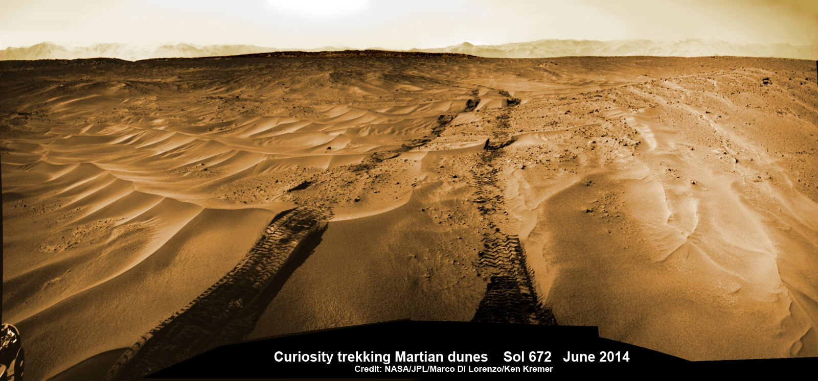
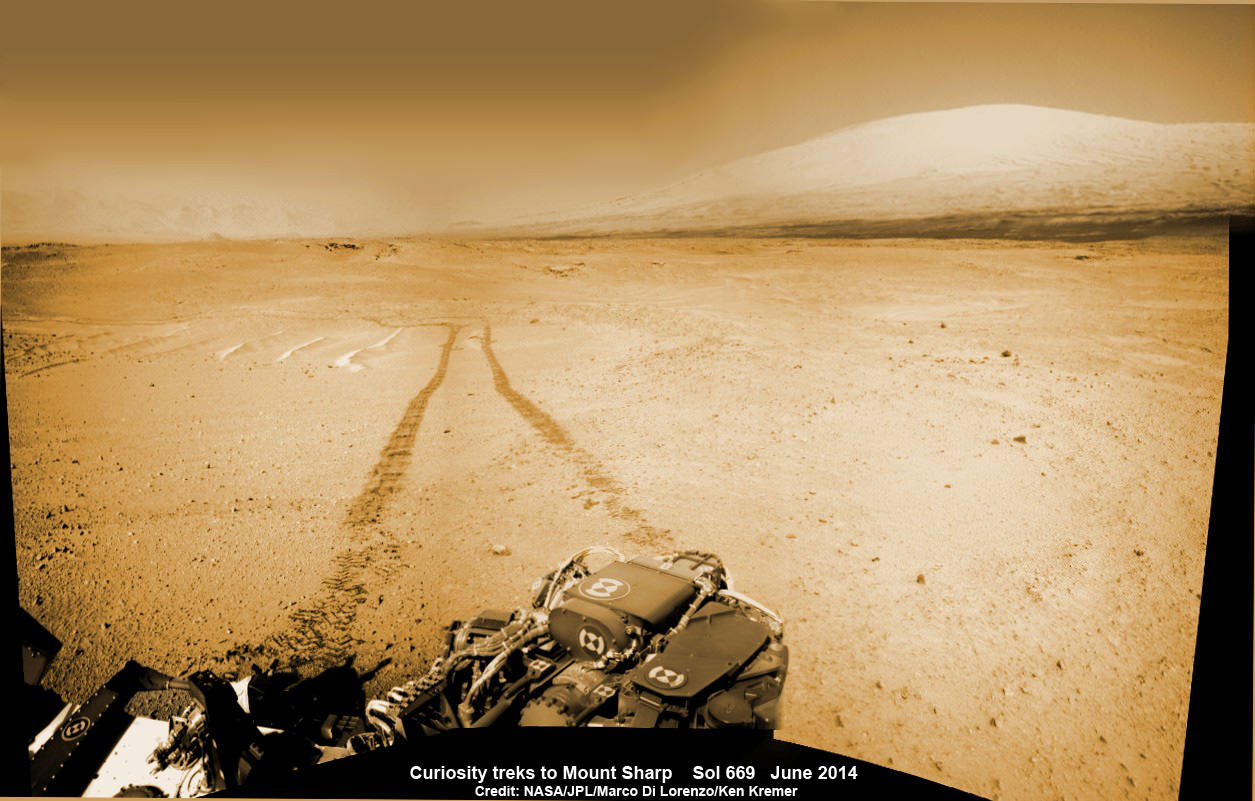
Curiosity treks across Martian dunes and drives outside landing ellipse here, in this photo mosaic view captured on Sol 672, June 27, 2014. Navcam camera raw images stitched and colorized. Credit: NASA/JPL-Caltech/Marco Di Lorenzo/Ken Kremer – kenkremer.com
Trekking Mars – NASA’s intrepid robot Curiosity is roving rapidly across the sandy ripples of the Red Planet in her quest to reach mysterious Mount Sharp and just drove outside her landing ellipse!
The six wheeled rover marked a major milestone on Sol 672, June 27, 2014, by traversing beyond her targeted landing ellipse for the first time since touchdown on Mars nearly two years ago on August 5, 2012.
“On yestersol’s drive [June 27], I left my landing ellipse—the 20×25 km area I targeted for landing,” Curiosity tweeted across interplanetary space.
See our new Sol 672 photo mosaic above showing Curiosity’s glorious view marking this major achievement just days ago.
Since switching paths to smoother, sandier terrain with less sharp edged rocks, Curiosity continues rolling across the floor of her Gale Crater landing site, pausing occasionally for potentially dicey dunes.
“After traversing 82 meters the rover stopped because it determined that it was slipping too much,” wrote mission scientist Ken Herkenhoff in an update.
“Coincidentally, the rover stopped right on the landing ellipse, a major mission milestone!”
1 Martian Year on Mars!
Curiosity treks to Mount Sharp in this photo mosaic view captured on Sol 669, June 24, 2014. Navcam camera raw images stitched and colorized. Credit: NASA/JPL-Caltech/Marco Di Lorenzo/Ken Kremer – kenkremer.com
“The vehicle was designed to be able to traverse far enough to drive out of the region defined by the uncertainty in the landing location, and has now achieved that laudable goal,” Herkenhoff confirmed.
The SUV sized rover automatically stopped when it encountered soft sand and sensed that it wasn’t making enough progress. It’s been programmed with this built in safety check to avoid being trapped in a quagmire of quicksand.
Curiosity crosses landing ellipse on Sol 672. Credit: NASA/JPL
Earlier last week, Curiosity celebrated another milestone anniversary on June 24 (Sol 669) – 1 Martian Year on Mars!
A Martian year is equivalent to 687 Earth days, or nearly two Earth years.
See our Sol 669 photo mosaic marking 1 Mars Year on Mars – above.
During Year 1 on Mars, Earth’s emissary has already accomplished her primary objective of discovering a habitable zone on the Red Planet that contains the minerals necessary to support microbial life in the ancient past.
So there’s no stopping Curiosity on her way to Mount Sharp, which dominates the center of Gale Crater and reaches 3.4 miles (5.5 km) into the Martian sky – taller than Mount Rainier.
Driving, Driving, Driving – that’s Curiosity’s number one priority as she traverses across the surface of Gale Crater towards towering Mount Sharp on an expedition in search of the chemical ingredients of life that could support Martian microbes if they ever existed.
Curiosity still has about another 2.4 miles (3.9 kilometers) to go to reach the entry way at a gap in the dunes at the foothills of Mount Sharp sometime later this year.
Curiosity rover panorama of Mount Sharp captured on June 6, 2014 (Sol 651) during traverse inside Gale Crater. Note rover wheel tracks at left. She will eventually ascend the mountain at the ‘Murray Buttes’ at right later this year. Assembled from Mastcam color camera raw images and stitched by Marco Di Lorenzo and Ken Kremer. Credit: NASA/JPL/MSSS/Marco Di Lorenzo/Ken Kremer-kenkremer.com
To date, Curiosity’s odometer totals over 5.1 miles (8.4 kilometers) since landing inside Gale Crater on Mars in August 2012. She has taken over 162,000 images.
Stay tuned here for Ken’s continuing Curiosity, Opportunity, Orion, SpaceX, Boeing, Orbital Sciences, commercial space, MAVEN, MOM, Mars and more planetary and human spaceflight news.
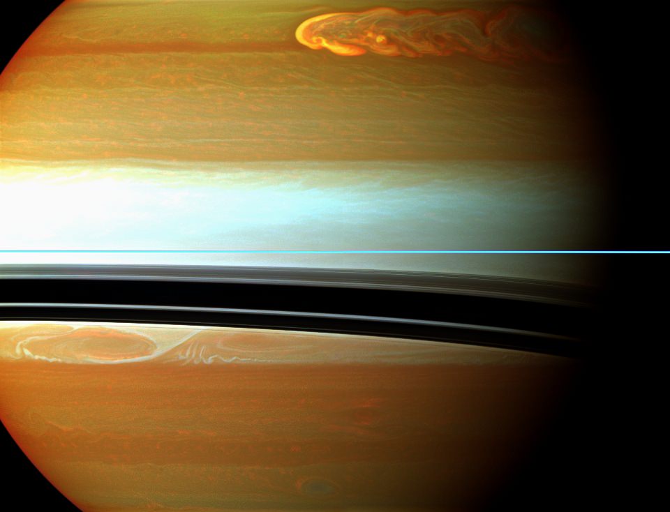
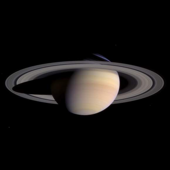
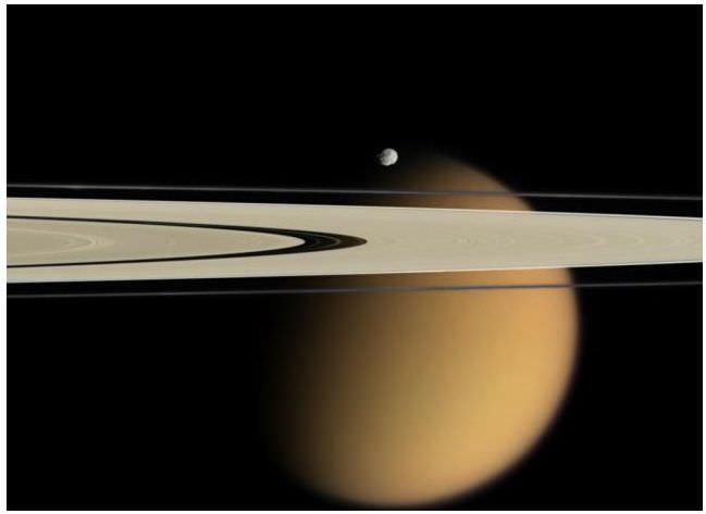
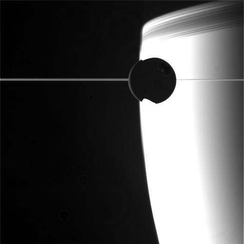
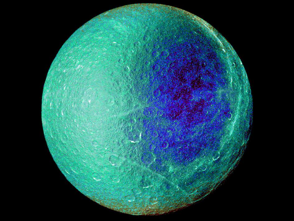
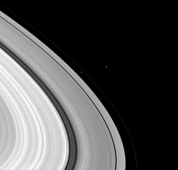
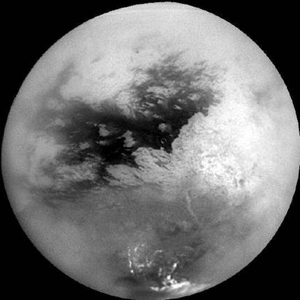
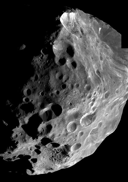
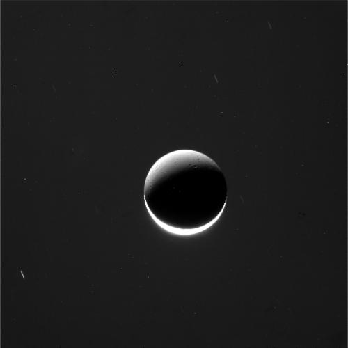
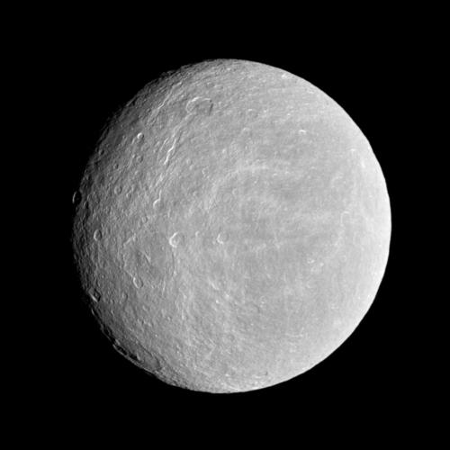
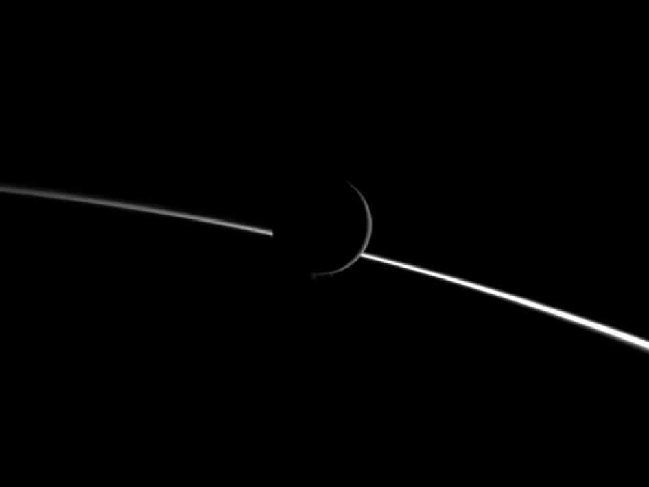
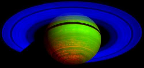
Saturn's northern storm marches through the planet's atmosphere in the top right of this false-color mosaic from NASA's Cassini spacecraft. Credit: NASA/JPL-Caltech/Space Science Institute
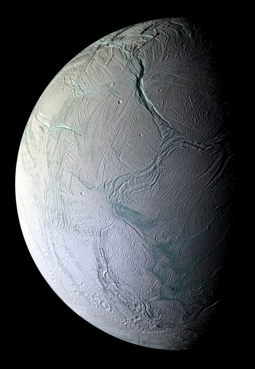
We’re spoiled, don’t you know? It was 10 years ago today that the Cassini spacecraft entered Saturn’s system, and it has been busily beaming back pictures of the ringed planet and its (many) moons ever since. We’ve learned more about seasons on Titan, investigated plumes on Enceladus, and examined phenomena such as auroras on Saturn.
Embedded in this story are 20 of our favourite pictures from Universe Today’s archive of Cassini discoveries, which you can check out below the jump.
It’s only a fraction of the more than 332,000 images received from the spacecraft, which is in excellent health and has seen its mission extended three times past its original 2008 expiry date. Additionally, more than 3,000 scientific papers have been generated. More cool stats in this NASA infographic.
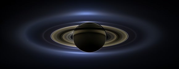
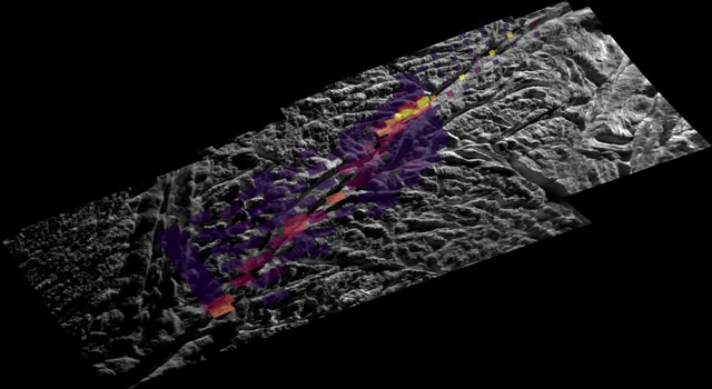
The full mosaic from the Cassini imaging team of Saturn on July 19, 2013… the “Day the Earth Smiled”In this unique mosaic image combining high-resolution data from the imaging science subsystem and composite infrared spectrometer aboard NASA’s Cassini spacecraft, pockets of heat appear along one of the mysterious fractures in the south polar region of Saturn’s moon Enceladus. Image credit: NASA/JPL/GSFC/SWRI/SSISaturn, imaged by Cassini on approach. Credit: CICLOPSTitan and Dione as seen by Cassini. Credit: NASA/JPL/Space Science InstituteThis image taken by the Cassini orbiter on Oct. 15, 2007, shows Saturn’s A and F rings, the small moon Epimetheus and smog-enshrouded Titan, the planet’s largest moon. The image is colorized to approximate the scene as it might appear to human eyes. (Credit: NASA/JPL/Space Science Institute)Cassini imaging scientists used views like this one to help them identify the source locations for individual jets spurting ice particles, water vapor and trace organic compounds from the surface of Saturn’s moon Enceladus. Credit: NASARaw image from Cassini on May 18. Credit: NASA/JPL/SSIHemispheric color differences on Saturn’s moon Rhea are apparent in this false-color view from NASA’s Cassini spacecraft. This image shows the side of the moon that always faces the planet. Image Credit: NASA/JPL/SSIThree of Saturn’s moons bunch together in this image by Cassini. Credit: NASA/JPL/Space Science Institute. Click for larger image.This mosaic of Titan was created from the first flyby of the moon by Cassini in 2004. Credit: NASA/JPL/SSPhoebe imaged by the Cassini spacecraft. Image Credit: NASACassini VIMS image of specular reflections in one of Titan’s lakes from a flyby on July 24, 2012 (NASA/JPL-Caltech/SSI/Jason W. Barnes et al.)A crescent Dione was seen by Cassini on January 29, 2011 from approximately 767,922 kilometers away. Credit: NASA/JPL/SSIRhea, as seen by Cassini. Credit: NASACassini captured this startling image of Saturn’s moon Hyperion. Photo Credit: NASA/JPLets of water ice particles spew from Saturn’s moon Enceladus in this image obtained by NASA’s Cassini spacecraft on Aug. 13, 2010. Image credit: NASA/JPL/SSIThis false-color composite image shows Saturn’s rings and southern hemisphere. The composite image was made from 65 individual observations by Cassini’s visual and infrared mapping spectrometer in the near-infrared portion of the light spectrum on Nov. 1, 2008. Credit: NASA/JPL/University of ArizonaThis mosaic of images from NASA’s Cassini spacecraft shows three fan-like structures in Saturn’s tenuous F ring. Such “fans” suggest the existence of additional objects in the F ring. Image credit: NASA/JPL/SSICassini came within 25 kilometers (15.6 miles) of the surface of Enceladus on Oct. 5, 2008. Image credit: NASA/JPL/Space Science Institute
NASA astronaut Reid Wiseman reacts mid-shave as fellow Expediton 40 crew member Alexander Gerst looks on. Wiseman and fellow NASA astronaut Steve Swanson both were shaved bald after the U.S. lost 1-0 to Germany in the 2014 FIFA World Cup. Credit: NASA / YouTube (screenshot)
Lose a soccer game and lose your hair. That’s apparently the deal that American astronauts made on the International Space Station last week, as commander Steve Swanson and Reid Wiseman both were shaved bald after the U.S. lost to Germany 1-0 June 26 in the FIFA World Cup. Gleefully wielding the shaver was Alexander Gerst, who happens to be from Germany.
Despite their busy science schedule, the astronauts have been enthusiastically following (and tweeting about!) the games. Not to mention they did a couple of improvised soccer matches in zero gravity, complete with awesome celebratory dances. You can check out all the video action below.
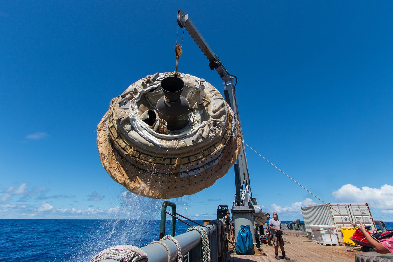
A recovery vessel lifts the Low-Density Supersonic Decelerator aboard after its June 28, 2014 test over the U.S. Navy's Pacific Missile Range. Credit: NASA/JPL-Caltech
Although the parachute didn’t pop out during a flight test this weekend of NASA’s flying-saucer shaped prototype spacecraft for future Mars exploration, the agency says the so-called Low-Density Supersonic Decelerator performed to expectations.
In an update released yesterday (June 30), one day after the craft made a hard landing in the Pacific, the agency noted that every goal on the flight had been met. The nature of the parachute failure is being investigated; the parachute was a year ahead of schedule in its development, according to NASA.
“The test vehicle worked beautifully, and we met all of our flight objectives,” stated Mark Adler, project manager for LDSD at NASA’s Jet Propulsion Laboratory in California. “We have recovered all the vehicle hardware and data recorders and will be able to apply all of the lessons learned from this information to our future flights.”
The flight test (which had been delayed for some time due to weather) saw LDSD soar into the sky on a high-altitude balloon launch that took it up to 120,000 feet (36,576 meters). As planned, the test vehicle was severed from the balloon to see how well it would perform during a simulated descent to the Martian surface.
The Low-Density Supersonic Decelerator (LDSD) soars into the sky during a test flight June 28, 2014 (invisible at top of contrail) while its carrier balloon floats in the frame. Credit: NASA/JPL-Caltech
With Martian spacecraft getting heavier, NASA is testing out new technologies to control spacecraft during the landing that would safely be able to navigate the Red Planet’s thin atmosphere. This test was supposed to see the LDSD leave the balloon while spinning sideways (somewhat like a football) and zoom to four times the speed of sound.
Next, it was supposed to deploy a Supersonic Inflatable Aerodynamic Decelerator to slow down to 2.5 Mach (speed of sound) and then pop the parachute. The SIAD did inflate as planned, but not the parachute.
“All indications are that the SIAD deployed flawlessly, and because of that, we got the opportunity to test the second technology, the enormous supersonic parachute, which is almost a year ahead of schedule,” stated Ian Clark, principal investigator for LDSD at JPL.
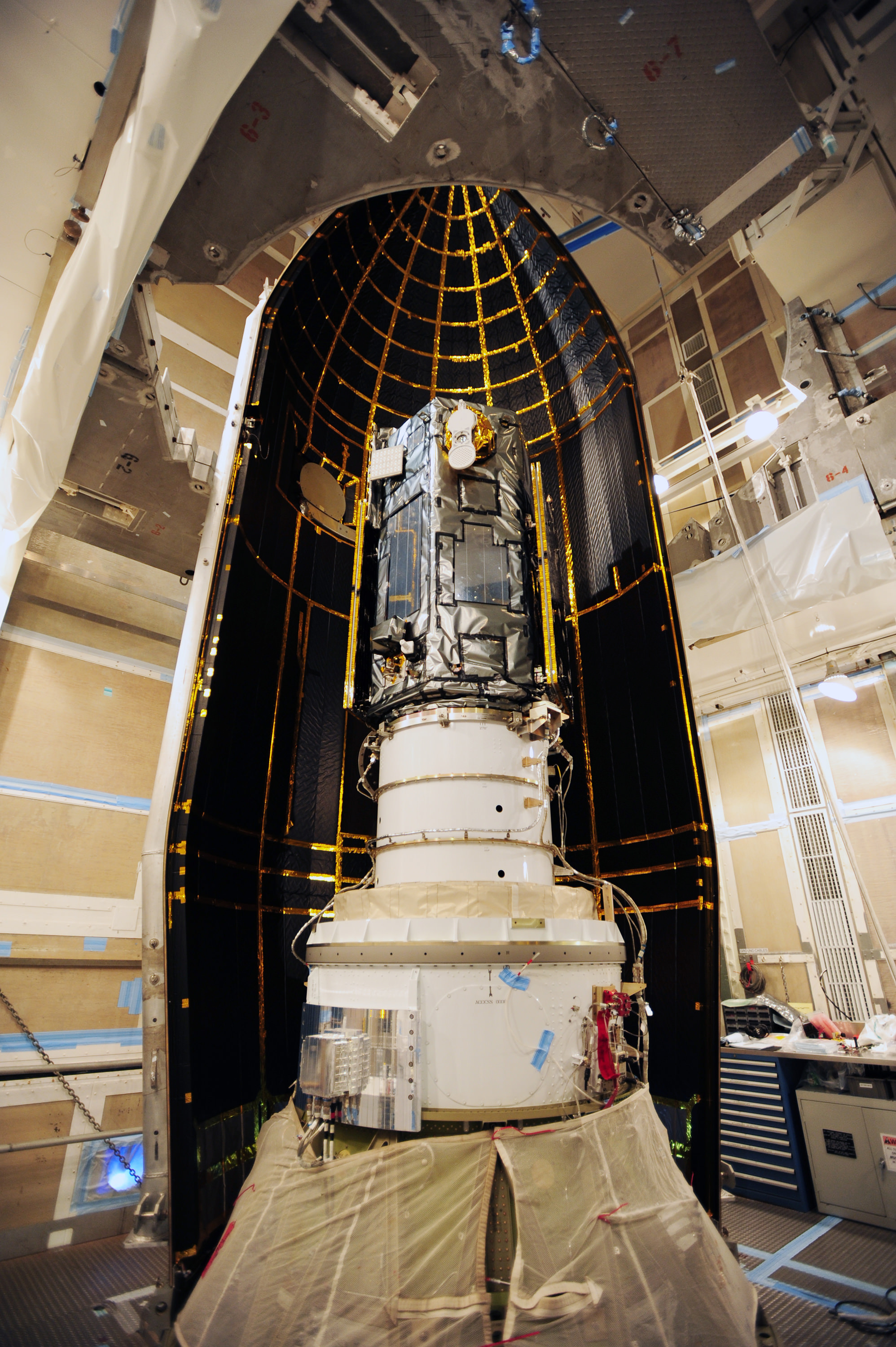
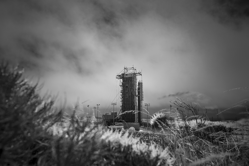
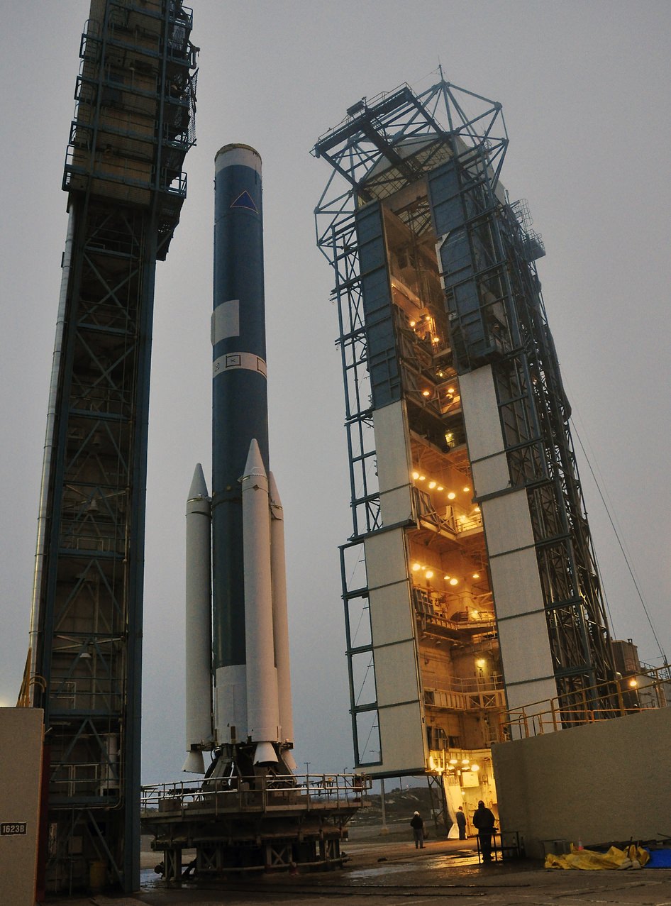
NASA’s Orbiting Carbon Observatory-2 (OCO-2) at the Launch Pad. This black-and-white infrared view shows the launch gantry, surrounding the United Launch Alliance Delta II rocket with the Orbiting Carbon Observatory-2 (OCO-2) satellite onboard. The photo was taken at Space Launch Complex 2, Friday, June 27, 2014, Vandenberg Air Force Base, Calif. OCO-2 is set for a July 1, 2014 launch. Credit: NASA/Bill Ingalls
NASA’s Orbiting Carbon Observatory-2 (OCO-2) at the Launch Pad
This black-and-white infrared view shows the launch gantry, surrounding the United Launch Alliance Delta II rocket with the Orbiting Carbon Observatory-2 (OCO-2) satellite onboard. The photo was taken at Space Launch Complex 2, Friday, June 27, 2014, Vandenberg Air Force Base, Calif. OCO-2 is set for a July 1, 2014 launch. Credit: NASA/Bill Ingalls[/caption]
After a lengthy hiatus, the workhorse Delta II rocket that first launched a quarter of a century ago and placed numerous renowned NASA science missions into Earth orbit and interplanetary space, as well as lofting dozens of commercial and DOD missions, is about to soar again this week on July 1 with NASA’s Orbiting Carbon Observatory-2 (OCO-2) sniffer to study atmospheric carbon dioxide (CO2).
OCO-2 is NASA’s first mission dedicated to studying atmospheric carbon dioxide, the leading human-produced greenhouse gas and the principal human-produced driver of climate change.
The 999 pound (454 kilogram) observatory is equipped with one science instrument consisting of three high-resolution, near-infrared spectrometers fed by a common telescope. It will collect global measurements of atmospheric CO2 to provide scientists with a better idea of how CO2 impacts climate change. OCO-2’s Delta II Rocket, First Stage At Space Launch Complex 2 on Vandenberg Air Force Base in California, the mobile service tower rolls away from the launch stand supporting the first stage of the Delta II rocket for NASA’s Orbiting Carbon Observatory-2 mission. Three solid rocket motors (white) have been attached to the first stage. The photo was taken during operations to mate the rocket’s first and second stages. Credit: NASA/Randy Beaudoin
The $467.7 million OCO-2 mission is set to blastoff atop the United Launch Alliance (ULA) Delta II rocket on Tuesday, July 1 from Space Launch Complex 2 at Vandenberg Air Force Base in California.
Liftoff is slated for 5:56 a.m. EDT (2:56 a.m. PDT) at the opening of a short 30-second launch window.
The California weather prognosis is currently outstanding at 100 percent ‘GO’ for favorable weather conditions at launch time.
OCO-2 poster. Credit: ULA/NASA
The two stage Delta II 7320-10 launch vehicle is 8 ft in diameter and approximately 128 ft tall. It is equipped with a trio of strap on solid rocket motors. This marks the 152nd Delta II launch overall and the 51st for NASA since 1989.
The last time a Delta II rocket flew was nearly three years ago in October 2011 from Vandenberg for the Suomi National Polar-Orbiting Partnership (NPP) weather satellite.
The Delta II will boost OCO-2 into a 438-mile (705-kilometer) altitude, near-polar orbit. Spacecraft separation from the rocket occurs 56 minutes 15 seconds after launch.
It will lead a constellation of five other international Earth monitoring satellites that circle Earth.
NASA’s Orbiting Carbon Observatory-2, or OCO-2, inside the payload fairing in the mobile service tower at Space Launch Complex 2 on Vandenberg Air Force Base in California. The fairing will protect OCO-2 during launch aboard a United Launch Alliance Delta II rocket, scheduled for 5:56 a.m. EDT on July 1. OCO-2 is NASA’s first mission dedicated to studying atmospheric carbon dioxide, the leading human-produced greenhouse gas driving changes in Earth’s climate. Credit: NASA/30th Space Wing USAF
The phone-booth sized OCO-2 was built by Orbital Sciences and is a replacement for the original OCO which was destroyed during the failed launch of a Taurus XL rocket from Vandenberg back in February 2009 when the payload fairing failed to open properly.
OCO-2 is the second of NASA’s five new Earth science missions launching in 2014 and is designed to operate for at least two years during its primary mission. It follows the successful blastoff of the joint NASA/JAXA Global Precipitation Measurement (GPM) Core Observatory satellite on Feb 27.
Orbiting Carbon Observatory-2 (OCO-2) mission will provide a global picture of the human and natural sources of carbon dioxide, as well as their “sinks,” the natural ocean and land processes by which carbon dioxide is pulled out of Earth’s atmosphere and stored, according to NASA..
“Carbon dioxide in the atmosphere plays a critical role in our planet’s energy balance and is a key factor in understanding how our climate is changing,” said Michael Freilich, director of NASA’s Earth Science Division in Washington.
“With the OCO-2 mission, NASA will be contributing an important new source of global observations to the scientific challenge of better understanding our Earth and its future.”
Artist’s rendering of NASA’s Orbiting Carbon Observatory (OCO)-2, one of five new NASA Earth science missions set to launch in 2014, and one of three managed by JPL. Credit: NASA-JPL/Caltech
It will record around 100,000 CO2 measurements around the world every day and help determine its source and fate in an effort to understand how human activities impact climate change and how we can mitigate its effects.
At the dawn of the Industrial Revolution, there were about 280 parts per million (ppm) of carbon dioxide in Earth’s atmosphere. As of today the CO2 level has risen to about 400 parts per million.
Stay tuned here for Ken’s continuing OCO-2, GPM, Curiosity, Opportunity, Orion, SpaceX, Boeing, Orbital Sciences, MAVEN, MOM, Mars and more Earth & Planetary science and human spaceflight news.
Blastoff of twin GRAIL A and B lunar gravity mapping spacecraft on a Delta II Heavy rocket on Sept. 10, 2011, from Pad 17B Cape Canaveral Air Force Station in Florida at 9:08 a.m. EDT. Credit: Ken Kremer/kenkremer.com
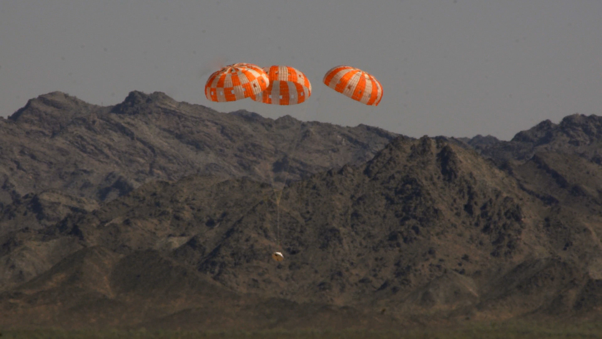
A test version of NASA’s Orion manned spacecraft descends under its three main parachutes above the U.S. Army Proving Ground in Arizona in the agency’s most difficult test of the parachutes system’s performance to prepare Orion for its first trip to space in December 2014. Credit: NASA/Rad Sinyak
A test version of NASA’s Orion deep space capsule has completed its most complex and last full flight-like parachute drop test on June 25 ahead of the maiden launch on the EFT-1 mission now slated for early December 2014.
The descent test was conducted at an altitude of 35,000 feet over the Arizona desert at the U.S. Army’s Yuma Proving Ground by pulling the test vehicle out of a huge C-17 cargo aircraft.
The test also included the addition of several added stress tests to check out the ability of the parachute system to compensate and examine capsule and astronaut crew survival via several potential failure modes.
For example, engineers rigged one of the main parachutes to skip the intermediate phase of the three-phase process to unfurl each of Orion’s three parachutes, called reefing.
“This tested whether one of the main parachutes could go directly from opening a little to being fully open without an intermediary step, proving the system can tolerate potential failures,” according to NASA.
The goal is to prove that that parachute system will slow Orion to ensure a safe landing speed for the astronaut crews returning from deep space missions to the Moon, Asteroids and eventually Mars.
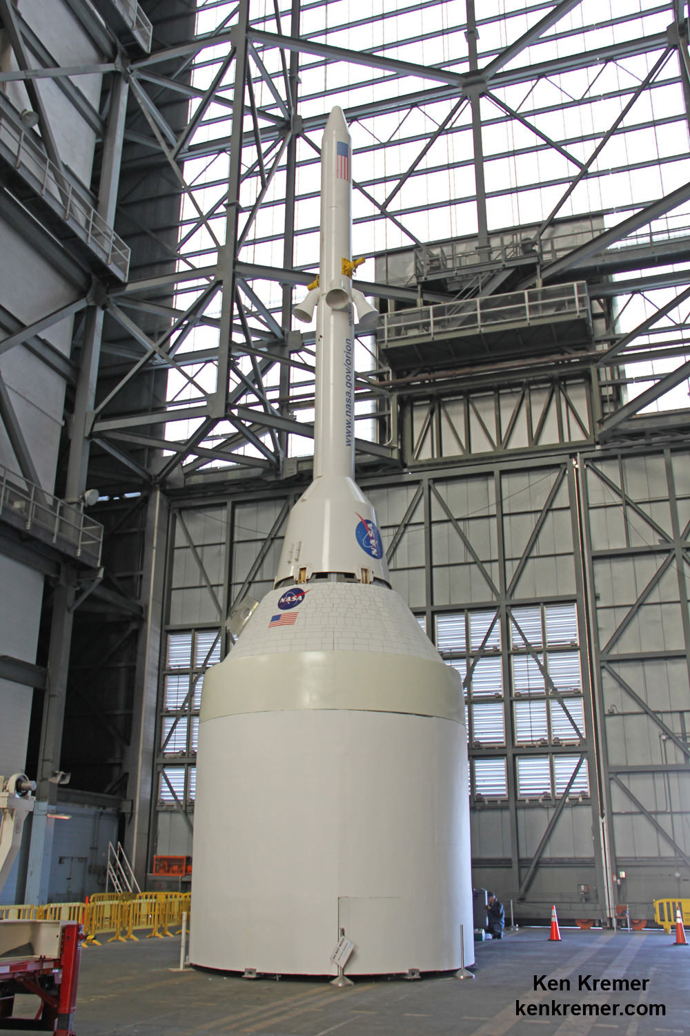
The Orion crew module for Exploration Flight Test-1 is shown in the Final Assembly and System Testing (FAST) Cell, positioned over the service module just prior to mating the two sections together. Credit: NASA/Rad Sinyak
“We’ve put the parachutes through their paces in ground and airdrop testing in just about every conceivable way before we begin sending them into space on Exploration Flight Test (EFT)-1 before the year’s done,” said Orion Program Manager Mark Geyer in a state
“The series of tests has proven the system and will help ensure crew and mission safety for our astronauts in the future.”
Orion is slated to launch on its inaugural unmanned EFT-1 test flight in December 2014 atop the mammoth, triple barreled United Launch Alliance (ULA) Delta IV Heavy rocket from Cape Canaveral, Florida.
Orion crew capsule, Service Module and 6 ton Launch Abort System (LAS) mock up stack inside the transfer aisle of the Vehicle Assembly Building (VAB) at the Kennedy Space Center (KSC) in Florida. Service module at bottom. Credit: Ken Kremer/kenkremer.com
This test also marked the last time that the entire parachute sequence involving the deployment of all three 116 foot-wide main chutes will be tested before the December launch.
For some of the parachutes, this was the highest altitude drop test attempted.
“Engineers also put additional stresses on the parachutes by allowing the test version of Orion to free fall for 10 seconds, which increased the vehicle’s speed and aerodynamic pressure,” NASA noted in a statement.
The parachute deployment and unfurling can only begin after jettisoning of the spacecraft’s forward bay cover. The chutes are housed below the cover which protects the chutes until reentry into Earth’s atmosphere.
The two-orbit, four- hour EFT-1 flight will lift the Orion spacecraft and its attached second stage to an orbital altitude of 3,600 miles, about 15 times higher than the International Space Station (ISS) – and farther than any human spacecraft has journeyed in 40 years.
One of the primary goals of NASA’s eagerly anticipated Orion EFT-1 uncrewed test flight is to test the efficacy of the heat shield in protecting the vehicle – and future human astronauts – from excruciating temperatures reaching 4000 degrees Fahrenheit (2200 C) during scorching re-entry heating.
At the conclusion of the EFT-1 flight, the detached Orion capsule plunges back and re-enters the Earth’s atmosphere at 20,000 MPH (32,000 kilometers per hour).
“That’s about 80% of the reentry speed experienced by the Apollo capsule after returning from the Apollo moon landing missions,” Scott Wilson, NASA’s Orion Manager of Production Operations at KSC, told me during an interview at KSC.
The parachute system comprising of two drogue parachutes and a trio of main parachutes – nearly the size of a football field – will then unfurl to slow Orion down to just 20 mph for a safe splashdown and recovery by the US Navy in the Pacific Ocean.
The Orion EFT-1 mission will end with a splashdown in the Pacific Ocean. During the stationary recovery test of Orion at Norfolk Naval Base on Aug. 15, 2013, US Navy divers attached tow lines and led the test capsule to a flooded well deck on the USS Arlington. Credit: Ken Kremer/kenkremer.com.
Another drop test scheduled for August will test the combined failure of one drogue parachute and one main parachute, as well as new parachute design features, says NASA.
Meanwhile, Orion’s prime contractor Lockheed Martin is finishing assembly and test operations of the EFT-1 capsule inside the Operations and Checkout Facility (O & C) at the Kennedy Space Center (KSC) flying in December’s launch
Stay tuned here for Ken’s continuing Orion, Orbital Sciences, SpaceX, commercial space, Curiosity, Mars rover, MAVEN, MOM and more planetary and human spaceflight news.