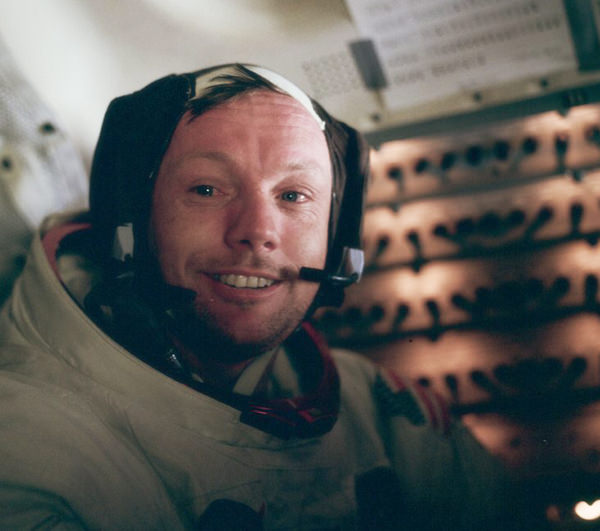
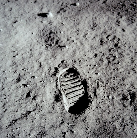
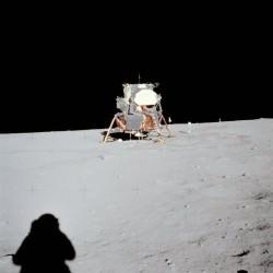
Neil Armstrong in the LM after his historic moonwalk (NASA)
Neil Armstrong — the first man on the moon, who died in 2012 — will now be the namesake of one of NASA’s research centers. A new law designated the Armstrong Flight Research Center took effect March 1, replacing the old name since 1976, the Dryden Flight Research Center.
Former NASA deputy administrator Hugh L. Dryden will still see his name in the area, however, as the center’s 12,000-square-mile (31,000-square-kilometer) Western Aeronautical Test Range is now called Dryden Aeronautical Test Range.
“I cannot think of a more appropriate way to honor these two leaders who broadened our understanding of aeronautics and space exploration,” stated NASA administrator Charles Bolden.
“Both Dryden and Armstrong are pioneers whose contributions to NASA and our nation still resonate today. Armstrong was the first person to walk on the moon. Dryden’s expertise at the National Advisory Committee for Aeronautics and then at NASA established America’s leadership in aerospace, and his vision paved the way for Armstrong to take those first steps.”
NASA astronaut Neil Armstrong earlier in his career, when he flew X-15s at the NACA High-Speed Flight Station (now called the NASA Armstrong Flight Research Center). Credit: NASA
At the center, Armstrong is probably best remembered for his flights in the X-15, a rocket-powered aircraft that set several altitude and speed records in the 1960s. At what was then the NACA High-Speed Flight Station, he flew seven times in that particular experimental aircraft, along with 41 other kinds of aircraft, between 1955 and 1962. Armstrong was also involved with development of a predecessor to a lunar landing training vehicle used in the Apollo missions (which almost killed Armstrong in a practice run for Apollo 11).
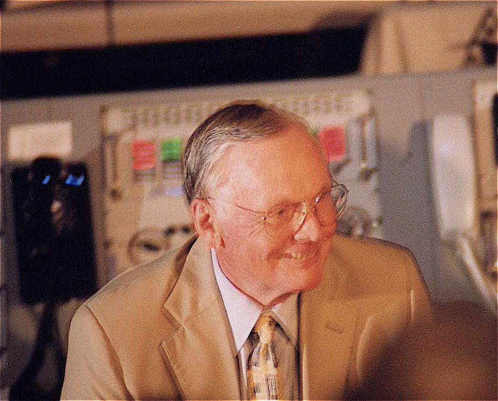
Neil Armstrong at the Kennedy Space Center (KSC) Saturn V Exhibit (Control Room) for the 30th Anniversary of Apollo 11 on July 16, 1999. Credit: John Salsbury
Armstrong’s connection with the research center continued after he left the astronaut corps, when he was NASA’s deputy associate administrator for aeronautics. In this capacity, NASA wrote, he was “overseeing aeronautical research programs being conducted at the center, particularly its pioneering work on developing digital electronic flight control systems.”
The center is located on California’s Edwards Air Force Base. Renaming was directed in legislation authored by Rep. Kevin McCarthy (R) of California’s 22nd district (and also the house majority whip), NASA stated. After the bill passed the U.S. House of Representatives in 2013 and the Senate in January, President Barack Obama signed the name into law Jan. 16. A renaming ceremony is expected in the spring.
Armstrong is the second astronaut to have a center named after him. The Lewis Research Center in Cleveland was renamed Glenn Research Center after Sen. John Glenn (D) in 1999. Glenn flew twice in space. In 1962, Glenn became the first American to orbit the Earth. He then returned to space in 1998 at the age of 77, becoming the oldest person to fly in space to date.
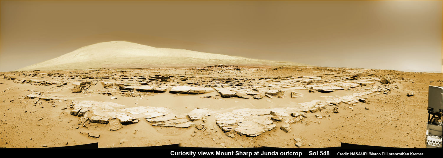
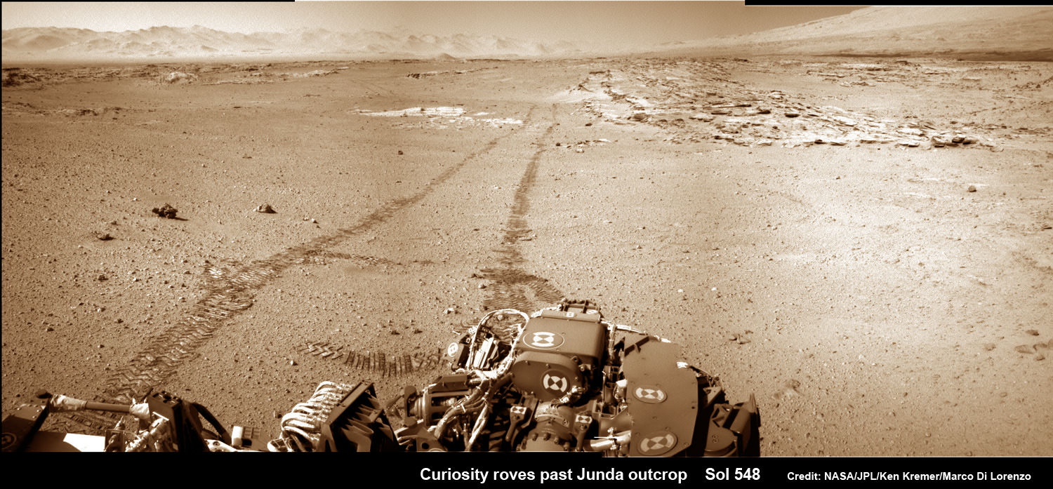
Mars rock rows and Mount Sharp. Martian landscape scene with rows of striated rocks in the foreground and Mount Sharp on the horizon. NASA's Curiosity Mars rover paused mid drive at the Junda outcrop to snap the component images for this navcam camera photomosaic on Sol 548 (Feb. 19, 2014) and then continued traveling southwards towards mountain base. UHF Antenna at right. Credit: NASA/JPL-Caltech/Marco Di Lorenzo/Ken Kremer-kenkremer.com
Mars rock rows and Spectacular Mount Sharp
Martian landscape scene with rows of striated rocks in the foreground and spectacular Mount Sharp on the horizon. NASA’s Curiosity Mars rover paused mid drive at the Junda outcrop to snap the component images for this colorized navcam camera photomosaic on Sol 548 (Feb. 19, 2014) and then continued traveling southwards towards mountain base. UHF Antenna at right.
Credit: NASA/JPL-Caltech/Marco Di Lorenzo/Ken Kremer-kenkremer.com
See stereo 3-D and look back views below[/caption]
Like any good tourist, NASA’s rover Curiosity apparently couldn’t resist the photobug urge from a gorgeous Martian mountain scene she happened by recently and decided to pull over and enjoy the view.
So she stopped the dune buggy mid-drive on the sandy road to her daily destination one Sol last week on Feb. 19, powered up the camera suite and excitedly snapped a spectacular landscape view of a striated rock field dramatically back dropped by towering Mount Sharp on the horizon.
See our Mars rocks and Mount Sharp photomosaic above and a 3-D stereoscopic view from NASA below.
The sedimentary foothills of Mount Sharp, which reaches 3.4 miles (5.5 km) into the Martian sky, is the 1 ton robots ultimate destination inside Gale Crater because it holds caches of water altered minerals.
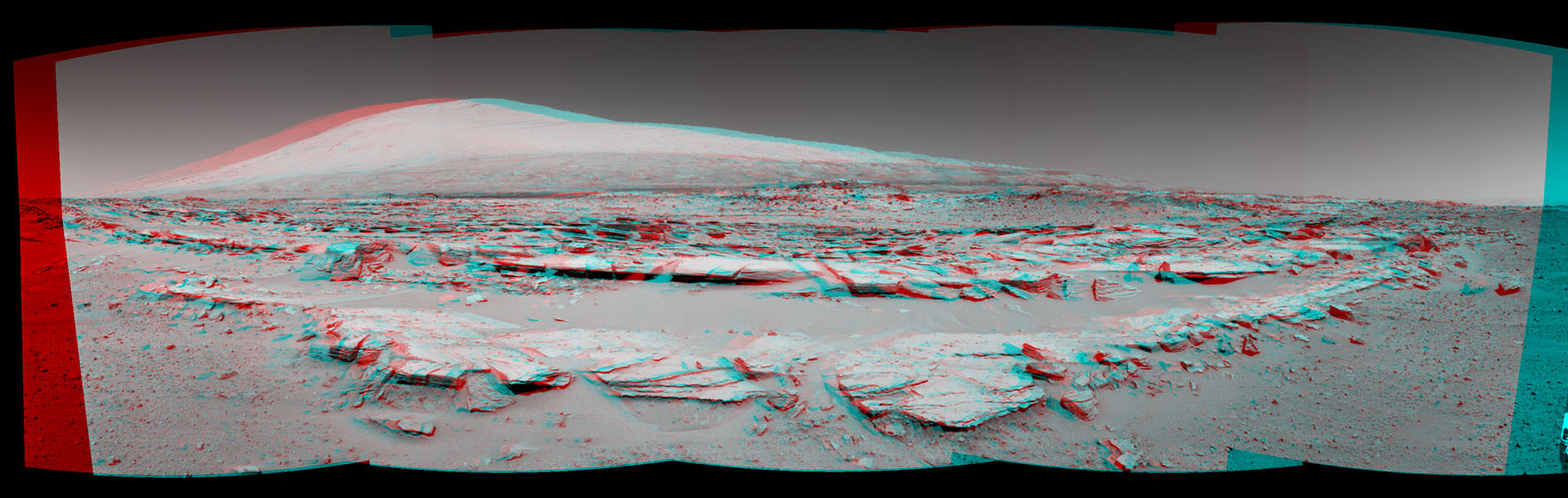
Martian Landscape With Rock Rows and Mount Sharp (Stereo) This stereo landscape scene from NASA’s Curiosity Mars rover on Feb. 19, 2014 shows rows of rocks in the foreground and Mount Sharp on the horizon. It appears three dimensional when viewed through red-blue glasses with the red lens on the left. Credit: NASA/JPL-Caltech
And just for good measure, Curiosity also snapped a series of breathtaking look back photos showing her tracks in the dune filled terrain from whence she came since straddling through the Dingo Gap gateway. See our mosaics below.
The panoramic mountain view taken on Sol 548 shows rows of striated rocks all oriented in a similar direction in the foreground with Mount Sharp in the background.
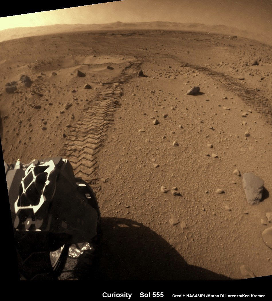
Curiosity looks back across dune field to her wheel tracks and a small crater she just missed. Flattened rear hazcam image, colorized from Sol 555 (Feb 27, 2014). Credit: NASA/JPL-Caltech/Marco Di Lorenzo/Ken Kremer-kenkremer.com
Scientists directed Curiosity to drive by the rock rows nicknamed “Junda” after their interest was piqued by orbital images taken by the powerful telescopic camera on NASA’s Mars Reconnaissance Orbiter (MRO) circling overhead.
The six wheeled rover paused during the planned Feb. 19 drive of 328 feet (100 meters) to capture the imagery.
She then pushed forward to finish the day’s drive and snapped another fabulous look back view – see our mosaic below.
And the next day on Feb. 20 (Sol 549), she also completed her second 100 meter drive in reverse.
Her handlers are occasionally commanding Curiosity to drive backwards in a newly tested bid to minimize serious damage to the six 20 inch diameter wheels in the form of rips and tears caused by rough edged Red Planet rocks – see our wheel mosaic below.
Curiosity looks back at Martian sand dunes and rover tracks after passing by Junda outcrop (right) on Sol 548 (Feb. 19, 2014) with Gale Crater rim and Mount Sharp on the distant horizon. Navcam colorized photomosaic. Credit: NASA/JPL-Caltech/Ken Kremer- kenkremer.com/Marco Di Lorenzo
Curiosity is well on the way to her next near term goal, which is a science waypoint, named Kimberly (formerly called KMS-9), which lies about half a mile ahead.
Kimberly is of interest to the science team because it sits at an the intersection of different rock layers and also features ground with striations like those at “Junda”.
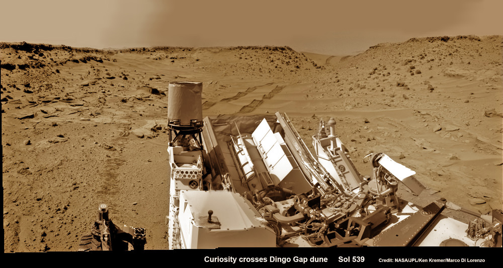
Curiosity looks back eastward to ‘Dingo Gap’ sand dune inside Gale Crater. After crossing over the 3 foot (1 meter) tall dune on Sol 539, Feb. 9, 2014 the rover drove westward into the ‘Moonlight Valley’. The parallel rover wheel tracks are 9 feet (2.7 meters) apart. Assembled from Sol 539 colorized navcam raw images. Credit: NASA/JPL/ Ken Kremer- kenkremer.com/Marco Di Lorenzo
So, after the rover reaches Kimberly, researchers plan to temporarily halt driving for awhile to investigate the location and direct the robot to drill into another rock to collect samples for analysis by the two state- of-the -art chemistry labs.
If drilling is warranted, Kimberly would be the site of Curiosity’s first drilling operation since the Cumberland outcrop target was bored into during the spring of 2013 at Yellowknife Bay.
Curiosity departed the Yellowknife Bay region in July 2013 where she discovered a habitable zone and thereby accomplished the primary goal of the mission.
To date Curiosity’s odometer stands at 5.3 kilometers and she has taken over 125,000 images.
The robot has somewhat less than another 5 km to go to reach the base of Mount Sharp.
She perhaps may arrive sometime in mid 2014.
Arrival time at Mount Sharp depends on driving speed and whether the upcoming terrain is smoother or strewn with sharp edged rocks that have hindered progress due to accumulating wear and tear on the aluminum wheels.
Up close photomosaic view shows lengthy tear in rover Curiosity’s left front wheel caused by recent driving over sharp edged Martian rocks on the months long trek to Mount Sharp. Raw images taken by the MAHLI camera on Curiosity’s arm on Jan. 31, 2014 (Sol 529) were assembled to show some recent damage to several of its six wheels Credit: NASA / JPL / MSSS / Marco Di Lorenzo / Ken Kremer- kenkremer.com See below complete 6 wheel mosaic and further wheel mosaics for comparison
Stay tuned here for Ken’s continuing Curiosity, Opportunity, Chang’e-3, GPM, SpaceX, Orbital Sciences, LADEE, MAVEN, MOM, Mars and more planetary and human spaceflight news. Learn more at Ken’s upcoming presentations at the NEAF convention on April 12/13.
Curiosity’s View Past Tall Dune at edge of ‘Dingo Gap’
This photomosaic from Curiosity’s Navigation Camera (Navcam) taken at the edge of the entrance to the Dingo Gap shows a 3 foot (1 meter) tall dune and valley terrain beyond to the west, all dramatically back dropped by eroded rim of Gale Crater. View from the rover’s current position on Sol 528 (Jan. 30, 2014). The rover team may decide soon whether Curiosity will bridge the dune gap as a smoother path to next science destination. Credit: NASA/JPL-Caltech/Marco Di Lorenzo/Ken Kremer- kenkremer.com
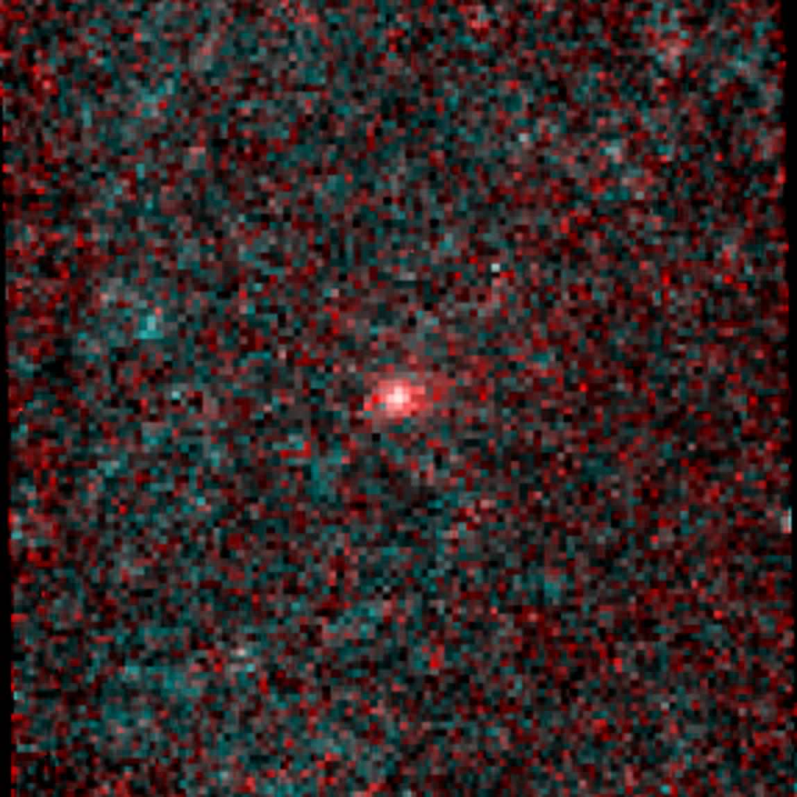
Infrared image of comet NEOWISE (C/2014 C3). Credit: NASA/JPL-Caltech
NASA’s NEOWISE mission — formerly known as just WISE — has identified the first comet of its new near-Earth object hunting career… and, according to mission scientists, it’s a “weirdo.”
In its former life NASA’s WISE (Wide-field Infrared Survey Explorer) spacecraft scanned the entire sky in infrared wavelengths. It helped discover the galaxy’s coldest stars, the Universe’s brightest galaxies, and some of the darkest asteroids lurking in the main asteroid belt between Mars and Jupiter… as well as closer in to Earth’s neck of the woods.
After exhausting its supply of liquid coolant needed to shield itself from its own radiating heat, in 2011 WISE was put into a state of hibernation. It was awoken last year and rebranded NEOWISE, and set upon the task of locating unknown objects with orbits in the proximity of Earth’s.
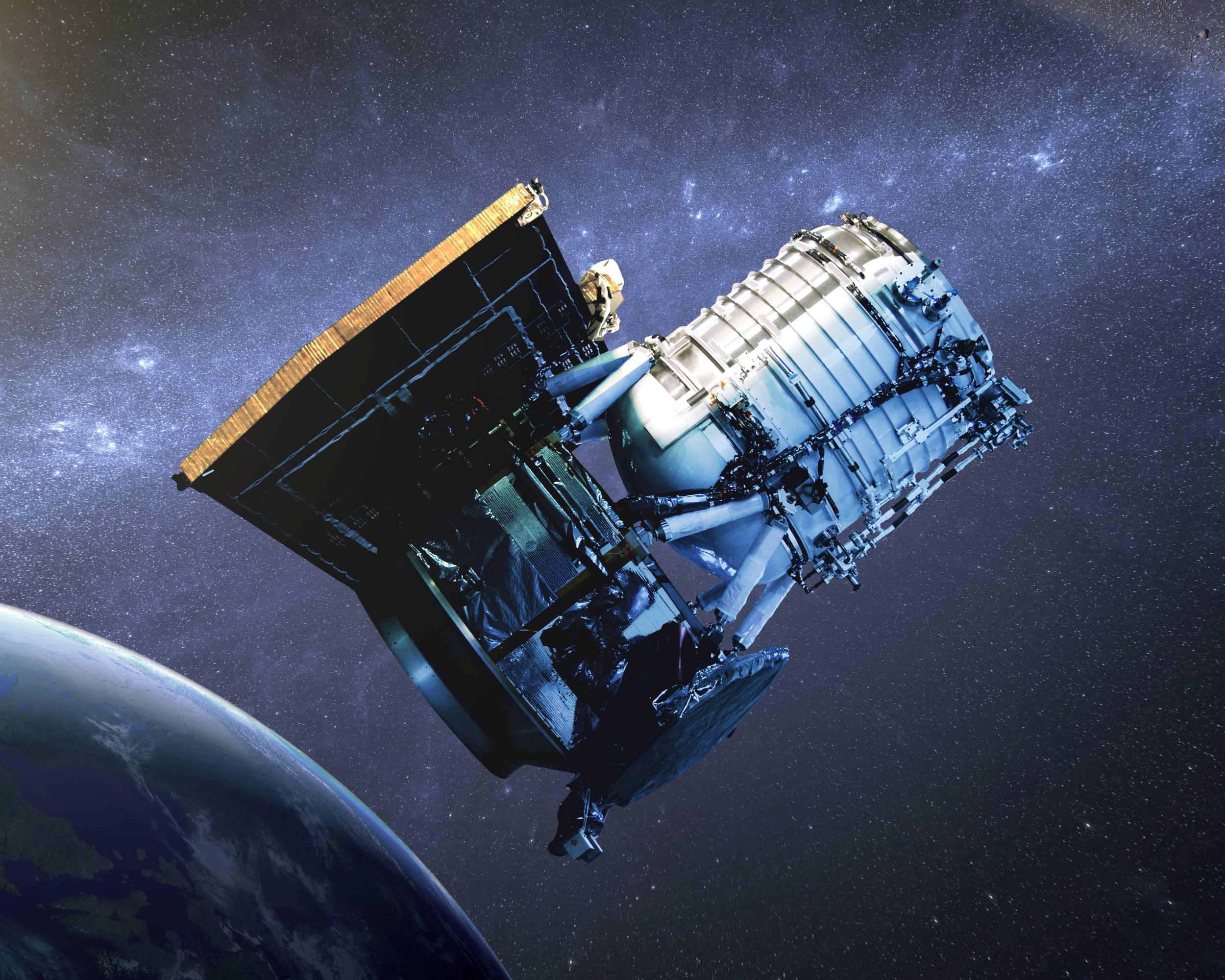
Artist’s impression of the WISE satellite
To date several new asteroids have already been found by NEOWISE, and on February 14, 2014, it spotted its first comet.
“We are so pleased to have discovered this frozen visitor from the outermost reaches of our solar system,” said Amy Mainzer, NEOWISE principal investigator at JPL. “This comet is a weirdo — it is in a retrograde orbit, meaning that it orbits the sun in the opposite sense from Earth and the other planets.”
Designated “C/2014 C3 (NEOWISE),” the comet was 143 million miles (230 million km) away in the image above — a composite made from six infrared exposures. That’s 585 times the distance to the Moon, or about the average distance between the Earth and Mars.
The tail of the comet NEOWISE extends about 25,000 miles (40,000 km) to the right in the image.
Overall, C/2014 C3 (NEOWISE) was spotted six times before it moved out of range of the spacecraft’s view. The comet has a highly-eccentric 20-year orbit that takes it high above the plane of the Solar System and out past the orbit of Jupiter. Technically, with a perihelion distance greater than 1.3 AU, comet C/2014 C3 does not classify as a near-Earth object (and its orbit does not intersect Earth’s.) But it’s still good to know that NEOWISE is looking out for us.
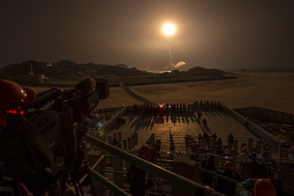
GPM Launch Seen From the Tanegashima Space Center. A Japanese H-IIA rocket with the NASA-Japan Aerospace Exploration Agency (JAXA), Global Precipitation Measurement (GPM) Core Observatory onboard, is seen launching from the Tanegashima Space Center on Friday, Feb. 28, 2014 (Japan Time), in Tanegashima, Japan; Thursday, Feb. 27, EST.. Credit: NASA/Bill Ingalls
GPM Launch Seen From the Tanegashima Space Center
A Japanese H-IIA rocket with the NASA-Japan Aerospace Exploration Agency (JAXA), Global Precipitation Measurement (GPM) Core Observatory onboard, is seen launching from the Tanegashima Space Center on Friday, Feb. 28, 2014 (Japan Time), in Tanegashima, Japan; Thursday, Feb. 27, EST. Credit: NASA/Bill Ingalls[/caption]
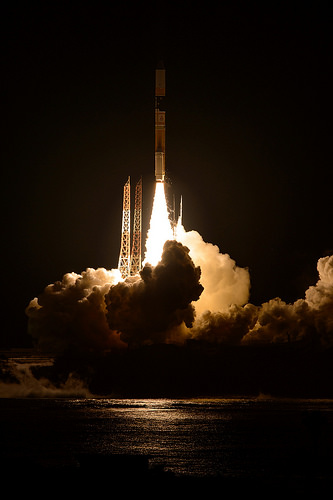
NASA GODDARD SPACE FLIGHT CENTER, MARYLAND – A powerful, next generation weather observatory aimed at gathering unprecedented 3-D measurements of global rain and snowfall rates – and jointly developed by the US and Japan – thundered to orbit today (Feb. 27 EST, Feb. 28 JST) ) during a spectacular night time blastoff from a Japanese space port.
The Global Precipitation Measurement (GPM) Core Observatory was launched precisely on time at 1:37 p.m. EST, 1837 GMT, Thursday, Feb. 27 (3:37 a.m. JST Friday, Feb. 28) atop a Mitsubishi Heavy Industries H-IIA rocket from the Tanegashima Space Center on Tanegashima Island off southern Japan.
Viewers could watch the spectacular liftoff live on NASA TV – which was streamed here at Universe Today.
“GPM’s precipitation measurements will look like a CAT scan,” Dr. Dalia Kirschbaum, GPM research scientist, told me during a prelaunch interview with the GPM satellite in the cleanroom at NASA’s Goddard Space Flight Center in Greenbelt, Md.
“The radar can scan through clouds to create a three dimensional view of a clouds structure and evolution.”
GPM lifts off on Feb. 27, EST (Feb. 28, JST) to begin its Earth-observing mission. Credit: NASA/Bill Ingalls
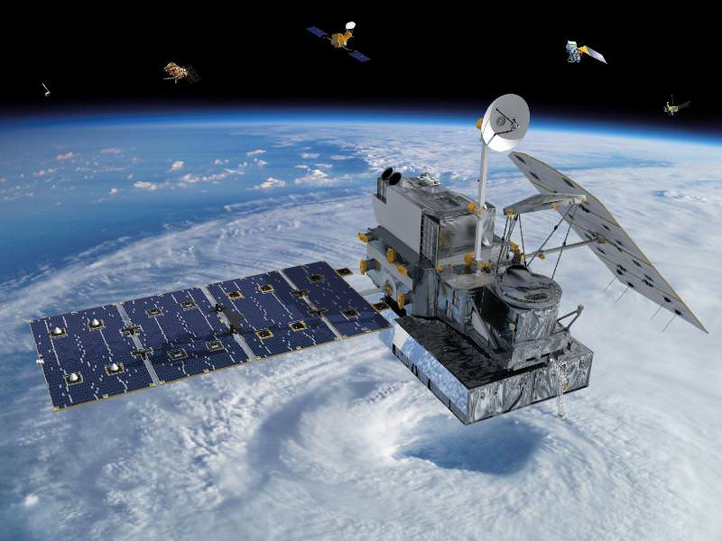
GPM is the lead observatory of a constellation of nine highly advanced Earth orbiting weather research satellites contributed by the US, Japan, Europe and India.
Indeed GPM will be the first satellite to measure light rainfall and snow, in addition to heavy tropical rainfall.
It will collect a treasure trove of data enabling the most comprehensive measurements ever of global precipitation every three hours – and across a wide swath of the planet where virtually all of humanity lives from 65 N to 65 S latitudes.
GPM orbits at an altitude of 253 miles (407 kilometers) above Earth – quite similar to the International Space Station (ISS).
The global precipitation data will be made freely available to climate researchers and weather forecasters worldwide in near real time – something long awaited and not possible until now.
Water and the associated water and energy cycles are the basis of all life on Earth.
Yet scientists lack a clear and comprehensive understanding of key rain and snow fall amounts on most of the globe – which is at the heart of humanity’s existence and future well being on the home planet.
Having an accurate catalog of the water and energy cycles will direct benefit society and impact people’s lives on a daily basis with improved weather forecasts, more advanced warnings of extreme weather conditions, aid farmers, help identify and determine the effects of global climate change.
Researchers will use the GPM measurements to study climate change, freshwater resources, floods and droughts, and hurricane formation and tracking.
“With this launch, we have taken another giant leap in providing the world with an unprecedented picture of our planet’s rain and snow,” said NASA Administrator Charles Bolden, in a NASA statement.
“GPM will help us better understand our ever-changing climate, improve forecasts of extreme weather events like floods, and assist decision makers around the world to better manage water resources.”
“The GPM spacecraft has been under development for a dozen years,” said GPM Project Manager Art Azarbarzin of NASA’s Goddard Space Flight Center in Greenbelt, Md., in a prelaunch interview with Universe Today conducted inside the clean room with GPM before it’s shipment to Japan.
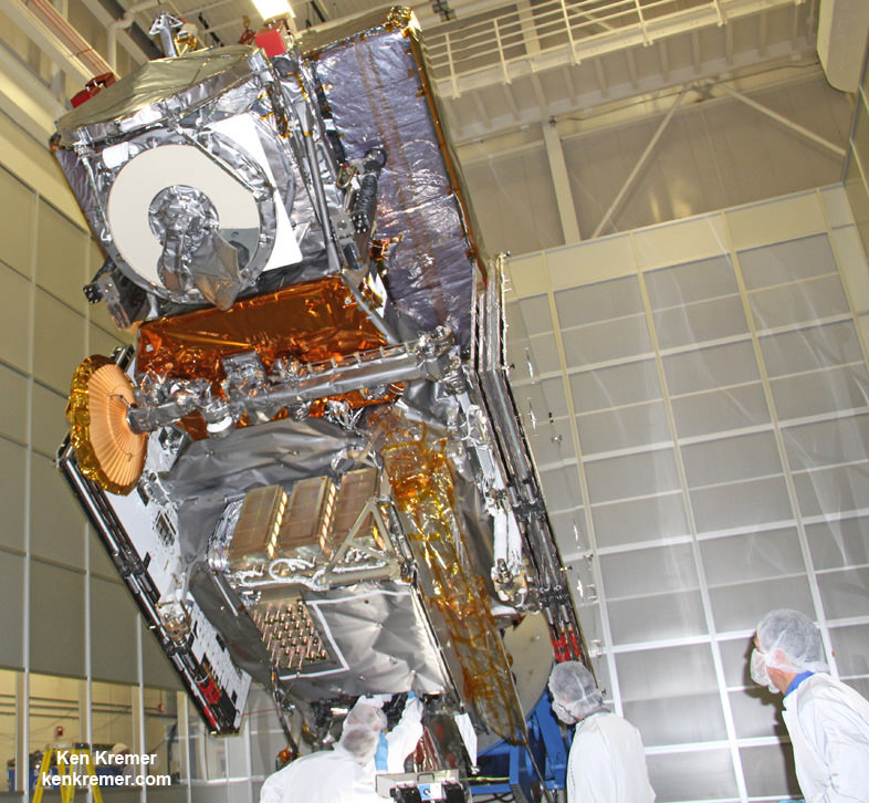
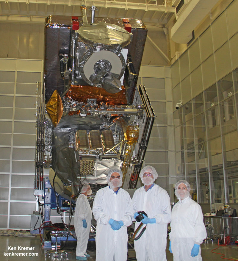
NASA’s next generation Global Precipitation Measurement (GPM) observatory inside the clean room at NASA Goddard Space Flight Center, MD. Technicians at work on final processing during exclusive up-close inspection tour by Universe Today. GPM is slated to launch on February 27, 2014 and will provide global measurements of rain and snow every 3 hours. Credit: Ken Kremer/kenkremer.com
“The GPM satellite was built in house by the dedicated team at NASA’s Goddard Space Flight Center in Maryland,” Azarbarzin told me.
“It’s the largest satellite ever built at Goddard.”
Following the flawless blastoff, the nearly four ton GPM spacecraft separated from the Japanese rocket some 16 minutes later at an altitude of 247 miles (398 kilometers).
10 minutes later both of the spacecrafts life giving solar arrays deployed as planned.
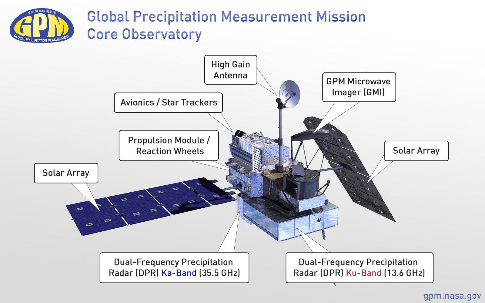
Major components of the GPM Core Observatory labeled, including the GMI, DPR, HGAS, solar panels, and more. Credit: NASA Goddard
“It is incredibly exciting to see this spacecraft launch,” said Azarbarzin, in a NASA statement. He witnessed the launch in Japan.
“This is the moment that the GPM Team has been working toward since 2006.”
“The GPM Core Observatory is the product of a dedicated team at Goddard, JAXA and others worldwide.”
“Soon, as GPM begins to collect precipitation observations, we’ll see these instruments at work providing real-time information for the scientists about the intensification of storms, rainfall in remote areas and so much more.”
The $933 Million observatory is a joint venture between the US and Japanese space agencies, NASA and the Japan Aerospace Exploration Agency (JAXA).
The 3850 kilogram GPM satellite is equipped with two instruments – an advanced, higher resolution dual -frequency precipitation (DPR) radar instrument (Ku and Ka band) built by JAXA in Japan and the GPM microwave imager (GMI) built by Ball Aerospace in the US.
The GPM observatory will replace the aging NASA/JAXA Tropical Rainfall Measuring Mission (TRMM) satellite launched back in 1997 and also jointly developed by NASA and JAXA.
“GPM is the direct follow-up to the currently orbiting TRMM satellite,” Azarbarzin explained to me.
“TRMM is reaching the end of its usable lifetime. After GPM launches we hope it has some overlap with observations from TRMM.”
GPM is vital to continuing the TRMM measurements. It will help provide improved forecasts and advance warning of extreme super storms like Hurricane Sandy and Super Typhoon Haiyan.
“TRMM was only designed to last three years but is still operating today. We hope GPM has a similar long life,” said Azarbarzin.
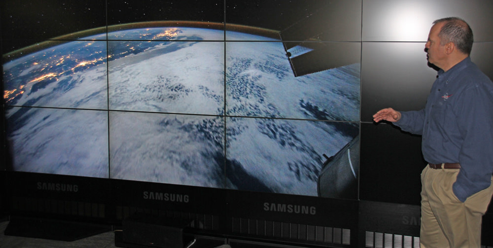
NASA astronaut Paul Richards (STS-102) discusses GPM at NASA Goddard Space Flight Center on Feb. 27, 2014. Credit: Ken Kremer/kenkremer.com
Stay tuned here for Ken’s continuing GPM reports and on-site coverage at NASA Goddard Space Flight Center in Maryland.
And watch for Ken’s continuing planetary and human spaceflight news about Curiosity, Opportunity, Chang’e-3, SpaceX, Orbital Sciences, LADEE, MAVEN, MOM, Mars, Orion and more.
Visualization of the GPM Core Observatory and Partner Satellites. GPM launched on Feb. 27 from Japan. Credit: NASANASA/JAXA Global Precipitation Measurement (GPM) satellite inside the clean room at NASA Goddard Space Flight Center, MD, undergoes final processing during exclusive up-close inspection tour by Universe Today: Dr. Art Azarbarzin/NASA GPM project manager, Dr. Ken Kremer/Universe Today and Dr. Dalia Kirschbaum/NASA GPM research scientist. Credit: Ken Kremer/kenkremer.com
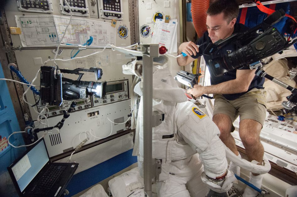
NASA astronaut Chris Cassidy examines a spacesuit during Expedition 36 in August 2013. Credit: NASA
Astronauts on the International Space Station “could have ignited flammable materials” on station while drying out a spacesuit that experienced a major leak during a spacewalk in July 2013, a new report reveals.
NASA Mission Control directed the Expedition 36 crew to use a vacuum cleaner to suction out the water, a procedure that inadvertently sucked up oxygen from the suit’s secondary high pressure oxygen tank, says a mishap report into the spacesuit leak incident. This “potentially hazardous risk” of electricity and pure oxygen created a fire hazard, the report added.
In a phone call with reporters yesterday (Feb. 27), report chair Chris Hansen added that the “levels of oxygen were perfectly safe” in this particular incident and that the “the risk to the crew in the end was none”, but said the incident still warranted attention in the 222-page report, which mainly deals with the spacesuit leak.
The incident occurred on July 17, 2013, one day after a “life-threatening” amount of water leaked into a spacesuit helmet used by Luca Parmitano, the report said. The astronauts and NASA were doing looking for the source of the leak. Astronauts reported no damage to the water bag and no water in the suit (which had been cleaned up after the spacewalk).
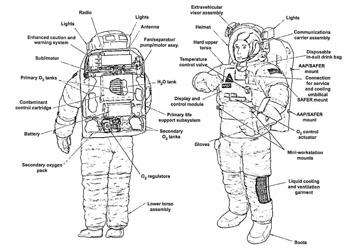
Parts of a NASA spacesuit used on board the International Space Station, as cited in a February 2014 report about a spacesuit leak the previous July. Credit: NASA
Next, they turned on the fan to the portable life support system (or backpack) with a secondary oxygen pack (SOP) check-out fixture. The fixture covered a vent port and oxygen switch for about 14 minutes. All appeared to be running normally, with no water detected. When the crew then removed the fixture (following procedure), they heard a “sucking” noise and the fan ceased moving, the report said.
“The crew was directed to turn off the suit fan and move the O2 Actuator to OFF. The crew then turned the suit fan back ON and again set the O2 Actuator to [the] IV [setting]. The fan briefly began spinning and then shut down almost immediately, with the crew reporting a water “sucking” or “gurgling” sound,” the report added.
The crew found “a few drops” of water in a canister outlet and “about a spoonful” of water in the suit inlet ports, as well as a few drops of water in a neck vent port. As the ground decided what to do, an infrared carbon-dioxide transducer in the suit “began to show an increase in its reading and eventually went off-scale high, most likely due to moisture in the vent loop near the CO2 [carbon dioxide] transducer,” the report stated.
Italian astronaut Luca Parmitano during a spacesuit fit check before his mission. Credit: NASA
With water in the suit, Mission Control then asked the crew to remove the water with a vacuum (one that is designed for wet or dry cleanup) as soon as the astronauts had the chance. Everything was normal until after the station emerged from a routine loss of signal, at which point controllers saw the secondary oxygen pack was turned on and reading 500 pounds per square inch lower than before the loss of communication.
“They quickly realized that their procedure had resulted in the EMU releasing 100% oxygen from the SOP into the vent loop, which was then sucked into the vacuum cleaner. This was a potentially dangerous situation involving unintended consequences,” the report said.
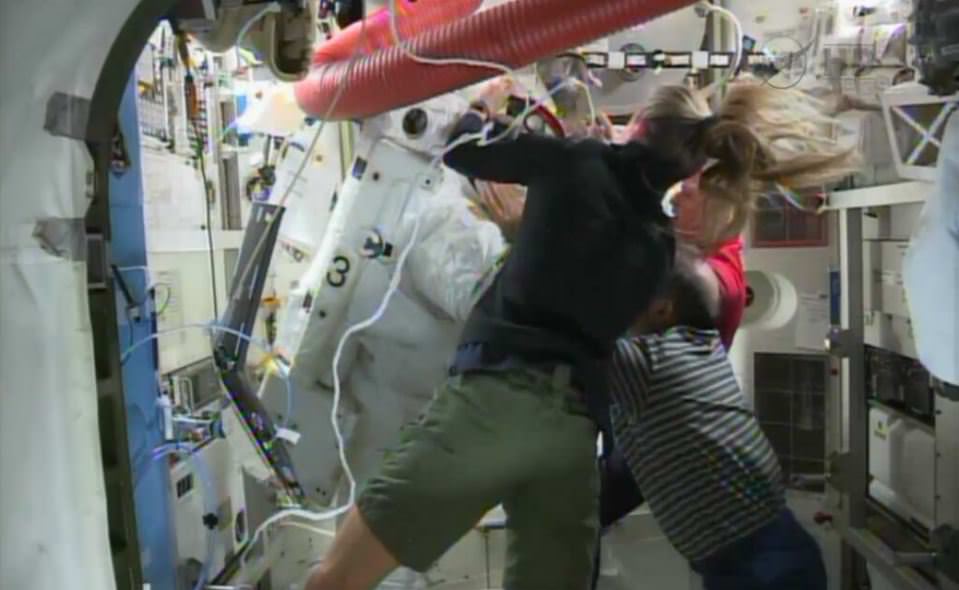
ISS Astronauts had to scramble to get Luca Parmitano out of his spacesuit after water leaked inside the suit, covering his face. Via NASA TV.
“During interviews, system experts indicated that they should have been able to anticipate SOP activation due to the reduced pressure created by the vacuum cleaner. The procedure was immediately stopped. No fire occurred and the crew was not harmed.”
In interviews after the incident, individuals spoke of “perceived pressure” to do the dry-out procedure quickly instead of first testing it on the ground with similar hardware. They instead used a non-functional spacesuit before directing the crew to do the procedure.
There were at least three factors contributing to that pressure, the report added: the desire to avoid corrosion in the suit, limited crew time, and the impending loss of signal.
The report did not identify any “additional causes, findings, or observations” from this event, noting that it is not technically an anomaly and was not classified as such in the NASA literature.
Luca Parmitano during a a spacewalk on July 16, 2013. An hour into the spacewalk, he reported water in his helmet and NASA cut the spacewalk short. Credit: NASA
While NASA’s Mission Control “performed admirably” during a spacewalk water leak crisis in July, a report on the incident showed that controllers did not send astronaut Luca Parmitano back to the airlock until after he made three calls saying the water didn’t appear to be from a drinking bag.
There are several reasons this happened, the mishap report says, such as inadequate training, the crew members and ground misunderstanding the severity of the situation, and a (false) perception that any water leak is likely due to a problem with the drinking bag.
Another big problem was the “normalization of deviance”, similar language to what was used during in reports describing the Challenger and Columbia incidents. In this case, small amounts of water in the helmet was expected, and controllers also misunderstood the cause of a carbon dioxide alarm (a fairly regular occurrence during spacewalks).
The report pulls no punches when it describes how bad things were: “The presence of this water created a condition that was life threatening.”
While talking about what is in the report, it’s also important to point out what the investigators did not find. There was no evidence that contractors were afraid to bring up problems (such as what happened during the 1986 Challenger explosion), chair Chris Hanson told reporters yesterday. Also, while the suits are 35 years old, no aging problem was detected.
Another couple of cautions: the report is preliminary (the exact cause of the leak is under investigation), it’s lengthy (222 pages) and much of the technical information is unavailable to the public due to export control restrictions. Any news story will just scratch the surface of what happened and the recommendations to fix it.
That said, here are a few key points we found in the report.
European Space Agency astronaut Luca Parmitano on a spacewalk July 9, 2013 during Expedition 36. Here, Parmitano is riding the end of the robotic Canadarm2. Credit: NASA
Parmitano warned controllers multiple times. The transcript shows three separate calls from Parmitano saying it wasn’t the drinking bag at cause: (1) “I feel a lot of water on the back of my head, but I don’t think it is from my bag.” (2) “The leak is not from the water bag and it is increasing.” (3) “I’m thinking that it might not be the water bag.” (In between 1 and 2, he also sent another call saying his “only guess” was it was the drinking bag, but the report adds that Parmitano may have softened his stance after speaking to controllers). Misunderstanding about the severity, lack of training, “cognitive overload” of controllers, and space-to-ground-to-space communication difficulties are all cited as contributing factors.
Drink bags don’t actually leak as much as people think they did. Unequivocally, the mishap investigation board says “the perception that drink bags leak, especially as a frequent occurrence, is false.” There has never been an instance of a bag leaking substantially during a spacewalk, the report says. After the crisis passed and investigators had the luxury of time, they in fact identified seven separate possible sources of water: (1) the bag; (2) the waste collection garment; (3) cooling water from the sublimator heat rejection component of the suit; (4) the Liquid Cooling Ventilation Garment connector or the tubing itself; (5) transfer lines through the Hard Upper Torso; (6) water storage tankage through the pressurizing bladders; (7) the water separator circuit (which is where the problem was eventually found).
It was a risky decision to send Parmitano back alone. Twenty-three minutes after Parmitano warned of water in his helmet, NASA terminated the spacewalk and as per procedure, had the astronaut head to the airlock while crewmate Chris Cassidy performed cleanup tasks before doing the same. (“Terminate” has a specific meaning as opposed to “abort”, which means both crew members leave immediately.) By this time, water was in Parmitano’s eyes and the station had passed into the shadow of the Earth, forcing him to feel his way back to the airlock along the tether. (This was only his second spacewalk on station, too.) Also, the water affected his communications equipment, as he made several calls “in the blind” that were not heard. At this time, Cassidy and the ground controllers did not know how severe the situation was. “Additional risk exposure that the team could have considered was the aspiration of water, failure of comm equipment, and impaired visibility,” the report said.
European Space Agency astronaut Luca Parmitano does spacesuit maintenance prior to July 9 and 16, 2013 spacewalks. Parmitano was a member of Expeditions 36 and 37. Credit: NASA
The emphasis on science on station can hinder with maintenance tasks. NASA and other space station partners are eager to demonstrate how great the station is to science, but crew time is divided between that and doing maintenance tasks. “Due to this knowledge, team members felt that requesting on-orbit time for anything non-science related was likely to be denied and therefore tended to assume their next course of action could not include on-orbit time,” the report states. To give a specific example of how this affected Parmitano’s suit: After water was found in the suit during a previous spacewalk, the crew and ground essentially determined it was due to the drink bag and did not probe further, partly because of the perception that doing an investigation would take an inordinate amount of time for little return (as they believed they knew the cause). On a related note, there was also the concern that investigating this occurrence (which happened on July 9) would delay the July 16 spacewalk. (Again, this sounds a bit like Challenger, where time pressure was cited as a reason to launch despite icy conditions.)
More needs to be done to understand the physics of water in a spacesuit. A few examples: it was believed the fan would have failed if water got through the separator unit, which did not occur. It was also believed that any water in the helmet would cling to the helmet, and not the crew member’s face. Not only that, the training for crew and ground was inadequate to seek out water causes on the fly. “Had this been done, the crew and ground team may not have attributed water in the helmet to just the drink bag,” the report stated.
Water in the helmet was normalized. If you’ve read Chris Hadfield’s An Astronaut’s Guide to Life On Earth, there’s an account in there about how Hadfield (who also was a junior spacewalker in 2001) became temporarily blind due to an anti-fog agent on the helmet getting into his eyes. This has happened during other spacewalks, too, which meant that the ground team was used to small amounts of water in the helmet — even though this wasn’t a normal condition. Another aspect: a carbon dioxide alarm went off in Parmitano’s suit after it became saturated with water. This happened six minutes before he felt the dampness. The team attributed this to “nominal accumulation of moisture in the vent loop,” which can happen at the end of the spacewalk. Having it happen less than an hour in, however, did not trigger a fault-finding process.
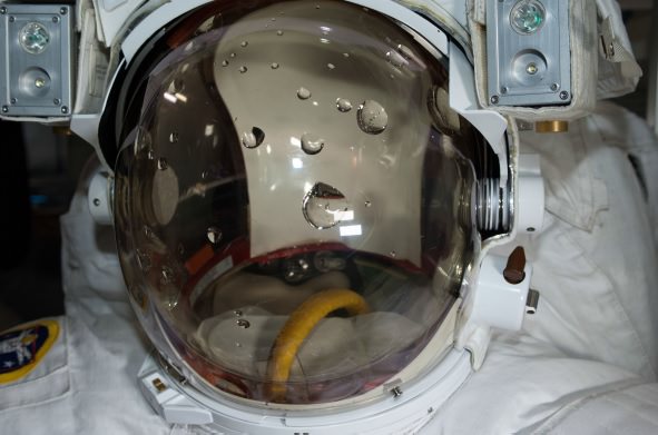
Water collecting inside of a spacesuit helmet. This was the lead image in a report investigating a July 2013 water leak in a spacesuit used by European Space Agency astronaut Luca Parmitano. Credit: NASA
While there are many, many causes in the report (with aspects ranging from the technical to the procedural to the training), members identified three main ones to the incident: (1) inorganic materials in the water separator drum holes, for reasons still unknown (2) a lack of understanding that meant the team’s response took longer than usual (3) a misdiagnosis of the water found during the July 9, 2013 spacewalk.
There are 49 separate recommendations ranging from “Level 1” priority to “Level 3”, which are still important but less urgent. NASA has pledged it will clear all “Level 1” and “Level 2” items before doing any normal spacewalks, although contingency ones are still possible. They expect this to be finished by June, but say they will take as long as needed to get the investigation done. There are no pressing spacewalk tasks on station right now.
Looking to the long run, the report noted that there should be more backups available if a fault is found in the spacesuits, as NASA is relying on these devices to perform essential station maintenance as far as 2028. Also, the investigators say that the six-year certification of these suits for orbital tasks is likely inadequate, and calls for a review of that. So although aging was not identified as an issue, maintenance and backups of the spacesuits could be key features of NASA thinking in the months and years to come.
Visualization of the GPM Core Observatory and Partner Satellites. Credit: NASA
Visualization of the GPM Core Observatory and Partner Satellites. GPM is slated to launch on Feb. 27 from Japan. Credit: NASA
See launch animation, Shinto ceremony, Rocket roll out and more below[/caption]
NASA GODDARD SPACE FLIGHT CENTER, MARYLAND – Blastoff of the powerful and revolutionary new NASA/JAXA rain and snow precipitation measurement satellite atop a Japanese rocket from a tiny offshore island launch pad is now less than 24 hours away on Thursday, Feb. 27, EST (Feb. 28 JST).
The Global Precipitation Measurement (GPM) Core Observatory aimed at improving forecasts of extreme weather and climate change research has been given a green light for launch atop a Mitsubishi Heavy Industries H-IIA rocket from the Tanegashima Space Center on Tanegashima Island off southern Japan.
Roll out of the H-IIA launch vehicle from the Vehicle Assembly Building is scheduled for this evening, Feb. 26 at 11 p.m. EST.
Update: rocket rolled out. Photo below, plus watch streaming NASA TV below.
Following the Launch Readiness Review, mission managers approved the GO for liftoff.
The H-IIA rocket with GPM rolls to its launch pad in Japan! Credit: NASA/Bill Ingalls
Japanese team members also prayed at a Shinto ceremony for blessings for a successful launch at the Ebisu Shrine, the first shrine in a traditional San-ja Mairi, or Three Shrine Pilgrimage on Tuesday, Feb. 25, 2014 – see photo below.
However, the team also set a newly revised launch time of 1:37 p.m. EST (18:37 UTC, and Feb. 28 at 3:37 a.m. JST).
Mission managers adjusted the H-IIA launch time after concerns raised by a collision avoidance analysis between the GPM spacecraft and the International Space Station (ISS).
GPM will fly at an altitude of 253 miles (407 kilometers) above Earth – quite similar to the ISS.
It’s coverage runs over virtually the entire populated globe from 65 N to 65 S latitudes.
NASA plans live coverage of the launch on Feb. 27 beginning at 12 noon EST on NASA Television.
It will be streamed live at: http://www.nasa.gov/nasatv
The $933 Million observatory is a joint venture between the US and Japanese space agencies, NASA and the Japan Aerospace Exploration Agency (JAXA).
NASA’s next generation Global Precipitation Measurement (GPM) observatory inside the clean room at NASA Goddard Space Flight Center, MD. Technicians at work on final processing during exclusive up-close inspection tour by Universe Today. GPM is slated to launch on February 27, 2014 and will provide global measurements of rain and snow every 3 hours. Credit: Ken Kremer/kenkremer.com
GPM has a one-hour launch window. In case of any delays, the team will be required to conduct a thorough new collision avoidance analysis to ensure safety.
Weather forecast is excellent at this time.
Watch this GPM Launch animation:
Video caption: NASA/JAXA GPM Core Observatory Launch Animation
GPM is a next-generation satellite that will provide global, near real time observations of rain and snow from space. Such data is long awaited by climate scientists and weather forecasters.
It will open a new revolutionary era in global weather observing and climate science. Therefore it will have a direct impact on society and people’s daily lives worldwide.
The mission will significantly advance our understanding of Earth’s water and energy cycles and improve forecasting of extreme weather events.
The 3850 kilogram GPM satellite is equipped with two instruments – an advanced, higher resolution dual -frequency precipitation (DPR) radar instrument (Ku and Ka band) built by JAXA in Japan and the GPM microwave imager (GMI) built by Ball Aerospace in the US.
Major components of the GPM Core Observatory labeled, including the GMI, DPR, HGAS, solar panels, and more. Credit: NASA Goddard
“The GPM satellite was built in house at NASA’s Goddard Space Flight Center in Maryland,” Art Azarbarzin, GPM project manager, told Universe Today during my exclusive up-close clean room inspection tour of the huge satellite as final processing was underway.
Researchers will use the GPM measurements to study climate change, freshwater resources, floods and droughts, and hurricane formation and tracking.
“GPM will join a worldwide constellation of current and planned satellites,” Azarbarzin told me during an interview in the Goddard cleanroom beside GPM.
“GPM is the direct follow-up to the currently orbiting TRMM satellite,” Azarbarzin explained.
“TRMM is reaching the end of its usable lifetime. After GPM launches we hope it has some overlap with observations from TRMM.”
“The Global Precipitation Measurement (GPM) observatory will provide high resolution global measurements of rain and snow every 3 hours,” Dalia Kirschbaum, GPM research scientist, told me during an interview at Goddard.
Stay tuned here for Ken’s continuing GPM reports and on-site coverage at NASA Goddard Space Flight Center in Maryland.
And watch for Ken’s continuing planetary and human spaceflight news about Curiosity, Opportunity, Chang’e-3, SpaceX, Orbital Sciences, LADEE, MAVEN, MOM, Mars, Orion and more.
GPM: Three Shrine Pilgrimage Japan Aerospace Exploration Agency (JAXA) team members bow at the Ebisu Shrine, the first shrine in a traditional San-ja Mairi, or Three Shrine Pilgrimage, where the team prays on Tuesday, Feb. 25, 2014 for a successful launch, Tanegashima Island, Japan. Credit: NASA/Bill IngallsNASA/JAXA Global Precipitation Measurement (GPM) satellite inside the clean room at NASA Goddard Space Flight Center, MD, undergoes final processing during exclusive up-close inspection tour by Universe Today: Dr. Art Azarbarzin/NASA GPM project manager, Dr. Ken Kremer/Universe Today and Dr. Dalia Kirschbaum/NASA GPM research scientist. Credit: Ken Kremer/kenkremer.com
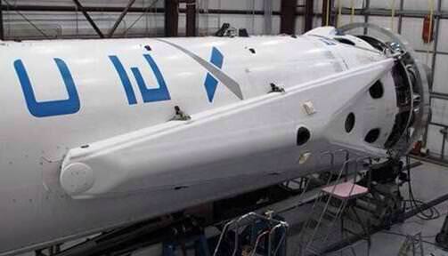
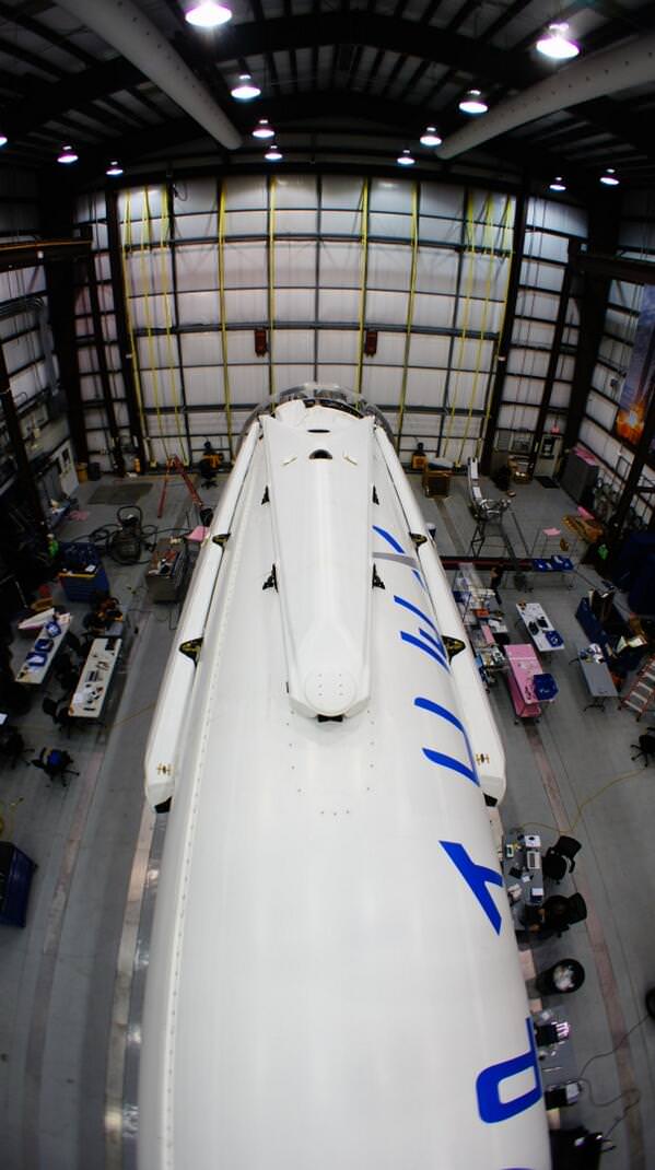
1st stage of SpaceX Falcon 9 rocket equipped with landing legs and now scheduled for launch to the International Space Station on March 16, 2014 from Cape Canaveral, FL. Credit: SpaceX/Elon Musk
1st stage of SpaceX Falcon 9 rocket newly equipped with landing legs and now scheduled for launch to the International Space Station on March 16, 2014 from Cape Canaveral, FL. Credit: SpaceX/Elon Musk
Story updated[/caption]
The next commercial SpaceXFalcon 9 rocket that’s set to launch in March carrying an unmanned Dragon cargo vessel will also be equipped with a quartet of landing legs in a key test that will one day lead to cheaper, reusable boosters, announced Elon Musk, the company’s founder and CEO.
The attachment of landing legs to the first stage of SpaceX’s new and more powerful, next-generation Falcon 9 rocket counts as a major step towards the firm’s eventual goal of building a fully reusable rocket.
Before attempting the use of landing legs “SpaceX needed to gain more confidence” in the new Falcon 9 rocket, Musk told me in an earlier interview.
Blastoff of the upgraded Falcon 9 on the Dragon CRS-3 flight is currently slated for March 16 from Cape Canaveral Air Force Station, Florida on a resupply mission to bring vital supplies to the International Space Station (ISS) in low Earth orbit for NASA.
“Mounting landing legs (~60 ft span) to Falcon 9 for next month’s Space Station servicing flight,” Musk tweeted, along with the up close photos above and below.
All four landing legs now mounted on Falcon 9 rocket being processed inside hanger at Cape Canaveral, FL for March 16 launch. Credit: SpaceX/Elon Musk
“SpaceX believes a fully and rapidly reusable rocket is the pivotal breakthrough needed to substantially reduce the cost of space access,” according to the firm’s website.
SpaceX hopes to vastly reduce their already low $54 million launch cost when a reusable version of the Falcon 9 becomes feasible.
Although this Falcon 9 will be sprouting legs, a controlled soft landing in the Atlantic Ocean guided by SpaceX engineers is still planned for this trip.
“However, F9 will continue to land in the ocean until we prove precision control from hypersonic thru subsonic regimes,” Musk quickly added in a follow-up twitter message.
In a prior interview, I asked Elon Musk when a Falcon 9 flyback would be attempted?
“It will be on one of the upcoming missions to follow [the SES-8 launch],” Musk told me.
“What we need to do is gain more confidence on the three sigma dispersion of the mission performance of the rocket related to parameters such as thrust, specific impulse, steering loss and a whole bunch of other parameters that can impact the mission.”
“If all of those parameters combine in a negative way then you can fall short of the mission performance,” Musk explained to Universe Today.
When the upgraded Falcon 9 performed flawlessly for the SES-8 satellite launch on Dec 3, 2013 and the Thaicom-6 launch on Jan. 6, 2014, the path became clear to attempt the use of landing legs on this upcoming CRS-3 launch this March.
Atmospheric reentry engineering data was gathered during those last two Falcon 9 launches to feed into SpaceX’s future launch planning, Musk said.
That new data collected on the booster stage has now enabled the approval for landing leg utilization in this March 16 flight.
SpaceX engineers will continue to develop and refine the technology needed to accomplish a successful touchdown by the landing legs on solid ground back at the Cape in Florida.
Extensive work and testing remains before a land landing will be attempted by the company.
Ocean recovery teams will retrieve the 1st stage and haul it back to port much like the Space Shuttle’s pair of Solid Rocket Boosters.
This will be the second attempt at a water soft landing with the upgraded Falcon 9 booster.
SpaceX founder and CEO Elon Musk briefs reporters including Universe Today in Cocoa Beach, FL prior to December 2013 SpaceX upgraded Falcon 9 rocket blastoff with SES-8 communications satellite from Cape Canaveral, FL. Credit: Ken Kremer/kenkremer.com
The two stage Falcon 9 rocket and Dragon cargo carrier are currently in the final stages of processing by SpaceX technicians for the planned March 16 night time liftoff from Space Launch Complex 40 at 4:41 a.m. that will turn night into day along the Florida Space Coast.
“All four landing legs now mounted on Falcon 9,” Musk tweeted today, Feb. 25.
SpaceX has carried out extensive landing leg and free flight tests of ever increasing complexity and duration with the Grasshopper reusable pathfinding prototype.
SpaceX is under contract to NASA to deliver 20,000 kg (44,000) pounds of cargo to the ISS during a dozen Dragon cargo spacecraft flights over the next few years at a cost of about $1.6 Billion.
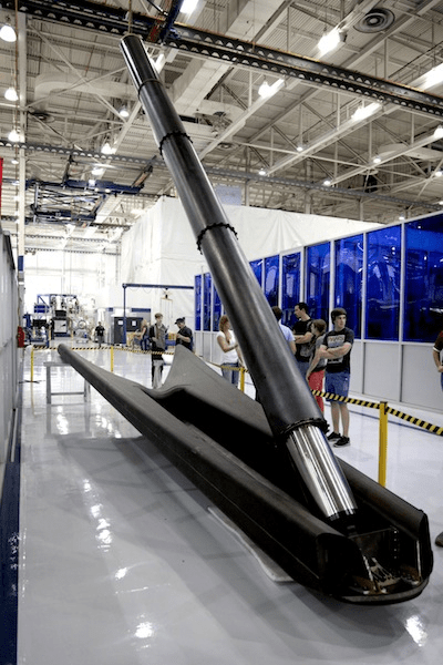
SpaceX Falcon 9 landing leg. Credit: SpaceX
To date SpaceX has completed two cargo resupply missions. The last flight dubbed CRS-2 blasted off a year ago on March 1, 2013.
The Falcon 9 and Dragon were privately developed by SpaceX with seed money from NASA in a public-private partnership.
The goal was to restore the cargo up mass capability the US completely lost following the retirement of NASA’s space shuttle orbiters in 2011.
SpaceX along with Orbital Sciences Corp are both partnered with NASA’s Commercial Resupply Services program.
This extra powerful new version of the Falcon 9 dubbed v1.1 is powered by a cluster of nine of SpaceX’s new Merlin 1D engines that are about 50% more powerful compared to the standard Merlin 1C engines. The nine Merlin 1D engines 1.3 million pounds of thrust at sea level rises to 1.5 million pounds as the rocket climbs to orbit.
The Merlin 1 D engines are arrayed in an octaweb layout for improved efficiency.
Next Generation SpaceX Falcon 9 rocket blasts off with SES-8 communications satellite on Dec. 3, 2013 from Pad 40 at Cape Canaveral, FL. Credit: Ken Kremer/kenkremer.com
Therefore the upgraded Falcon 9 can boost a much heavier cargo load to the ISS, low Earth orbit, geostationary orbit and beyond.
The next generation Falcon 9 is a monster. It measures 224 feet tall and is 12 feet in diameter. That compares to a 130 foot tall rocket for the original Falcon 9.
Stay tuned here for Ken’s continuing SpaceX, Orbital Sciences, commercial space, Orion, Chang’e-3, LADEE, Mars rover, MAVEN, MOM and more planetary and human spaceflight news – and upcoming launch coverage at Cape Canaveral & the Kennedy Space Center press site.
SpaceX CEO Elon Musk and Ken Kremer of Universe Today discuss Falcon 9/SES-8 launch nearby SpaceX Mission Control at Cape Canaveral Air Force Station. Florida. Credit: Ken Kremer/kenkremer.com
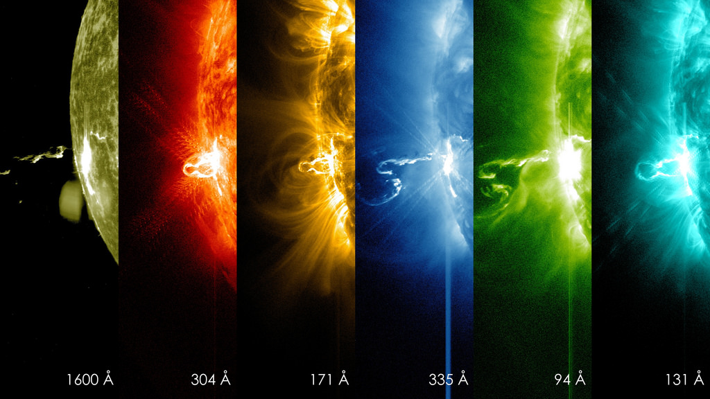
NASA's Solar Dynamics Observatory captured these images of a large flare erupting from the sun Feb. 21, 2014. Credit: NASA/SDO
She’s a rainbow! You can see the first moments of a huge flare belching off the sun in the picture above. The so-called X-class flare erupted a few hours ago (at 7:25 p.m. EST Feb. 24, or 12:25 a.m. UTC Feb. 25) and was captured by several spacecraft. If you have a pictures of the sun yourself to share, feel free to post them in the Universe Today Flickr pool.
NASA’s Solar Dynamics Observatory saw the flare growing in at least six different wavelengths of light, which are visible in the image above. This is classified this as an X4.9-class flare, which shows that it is pretty strong. X-flares are the most powerful kind that the sun emits, and each X number is supposed to be twice as intense as the previous one (so an X-2 flare is twice as powerful as X-1, for example).
SpaceWeather.com says this is the most powerful flare of the year so far, emitted from sunspot AR1967 (or more properly speaking, AR1990; sunspots are renamed if they survive a full rotation of the sun, as this one has done twice already!) While solar flares can lead to auroras, in this case it appears the blast was pointed in the wrong direction, the site added.
“Although this flare is impressive, its effects are mitigated by the location of the blast site–near the sun’s southeastern limb, and not facing Earth,” SpaceWeather stated. “Indeed, a bright coronal mass ejection (CME) which raced away from the sun shortly after the flare appears set to miss our planet.”
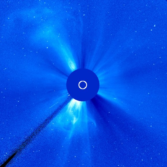
This image from the Solar and Heliospheric Observatory illustrates increased solar activity between Feb. 18-20, 2014. Credit: ESA/NASA/SOHO/GSFC
The sun goes through an 11-year cycle of sunspot and solar activity, which is supposed to be at its peak right now. This particular peak has been very muted, but lately things have been picking up. The European Space Agency noted that between Feb. 18 and 20, the sun sent out six CMEs in three days, with most of them moving in different directions.
“This level of activity is consistent with what we might expect as the Sun is near its maximum period of activity in the 11-year solar cycle,” ESA stated.
Neil Armstrong and Buzz Aldrin plant the US flag on the Lunar Surface during 1st human moonwalk in history 45 years ago on July 20, 1969 during Apollo 1l mission. Credit: NASA
A big challenge of making history “real” to students is finding a way to make it identifiable. Back in the early days of space exploration, it seemed every launch was on TV and every step to the moon extensively documented on radio, television and other media of the day. In an age where we just pull what we want off of social media and YouTube, the sense of excitement must be hard to convey to younger students.
To bring the inspiration of Apollo 11 to a younger audience, one high school teacher in Maryland took it upon himself to write a play for secondary school students — including much of the original transcript, right down to the “nouns” and “verbs” of the computers the astronauts used.
Richard Zmuda, who teaches in Annapolis, first came up with the idea three years ago after giving a National Honor Society speech to high schoolers where he cited alumni to the students, such as Apollo 11 lunar module pilot Buzz Aldrin.
“I had researched Aldrin for the speech and learned some fascinating details about him personally and about the mission in general,” Zmuda stated. “I realized that, while as a young boy I was able to watch on television Neil Armstrong’s first steps on the moon, none of the students could even remotely share in that experience. Yet it was one of the most important events in the history of mankind.”
Buzz Aldrin’s bootprint on the surface of the moon during the Apollo 11 mission on July 20, 1969. Credit: NASA
The result is a remarkably accurate adaptation of the mission transcript, and one that would be an interesting challenge for young thespians to bring to the stage. There are actual lines of dialog that sound close to what an astronaut of the day would say, such as “Your Co-Elliptic Sequence Initiation Time of Ignition: 125:19:3470.” Teaching the students how to convey a sense of drama, while staying true to the script, would be a fun exercise. It also would require some research so that the students understand what they’re talking about, which is likely the point that Zmuda wanted to convey.
That’s not to say that every line of dialog is that technical. Zmuda works to bring out the drama in several parts of the mission, including how Aldrin initially missed his first test “jump” back on to the lunar ladder and banged his shins against a rung. The staged Aldrin exclaims to the audience, “Well, at least I can say I was the first person to actually PEE on the moon,” something the real person never came close to saying. In a dramatic sense, however — especially given the age of the audience — this was a fun way to show how serious the situation could have been if Aldrin had more trouble getting back up.
Apollo 11 Mission image – Lunar Module at Tranquility Base
Even more interesting is Zmuda’s decision to keep the actors to between four and seven people — three astronauts and either a single person as CapCom in Mission Control, or three people representing the different shifts. This focuses the bulk of the attention on the astronauts, although “Houston” is intended to act as a dramatic foil during the frequent communications blackouts (which did happen in the real mission, too). It also makes it easy for a small drama class to stage the play.
The Apollo 11 adaptation is a fun read for space geeks, and likely is a good tool for teaching history at the high school level and above. Although the script is very technical at times, teaching students how to read this material can be equated to learning how to understand Shakespeare, or to deliver foreign words on stage. It’s a great effort by Zmuda, and hopefully will teach a few students about what the landing represented to space exploration.