Yutu Moon Rover Starts 3rd Night Time Hibernation But Technical Problems Persist

Chang’e-3/Yutu Timelapse Color Panorama This newly expanded timelapse composite view shows China’s Yutu moon rover at two positions passing by crater and heading south and away from the Chang’e-3 lunar landing site forever about a week after the Dec. 14, 2013 touchdown at Mare Imbrium. This cropped view was taken from the 360-degree timelapse panorama. See complete 360 degree landing site timelapse panorama herein and APOD Feb. 3, 2014. Chang’e-3 landers extreme ultraviolet (EUV) camera is at right, antenna at left. Credit: CNSA/Chinanews/Ken Kremer/Marco Di Lorenzo – kenkremer.com. See our complete Yutu timelapse pano at NASA APOD Feb. 3, 2014: http://apod.nasa.gov/apod/ap140203.htm

Chang’e-3/Yutu Timelapse Color Panorama
This newly expanded timelapse composite view shows China’s Yutu moon rover at two positions passing by crater and heading south and away from the Chang’e-3 landing site forever about a week after the Dec. 14, 2013 touchdown at Mare Imbrium. This cropped view was taken from the 360-degree timelapse panorama. See complete 360 degree landing site timelapse panorama herein and APOD Feb. 3, 2014. . Chang’e-3 landers extreme ultraviolet (EUV) camera is at right, antenna at left. Credit: CNSA/Chinanews/Ken Kremer/Marco Di Lorenzo – kenkremer.com.
See our complete Yutu timelapse pano at NASA APOD Feb. 3, 2014: http://apod.nasa.gov/apod/ap140203.htm
Story updated[/caption]

The world famous and hugely popular ‘Yutu’ rover entered its 3rd Lunar night time hibernation period this weekend as planned, but serious technical troubles persist that are hampering science operations Chinese space managers confirmed.

“China’s lunar rover Yutu entered its third planned dormancy on Saturday, with the mechanical control issues that might cripple the vehicle still unresolved,” reports Xinhua, China’s official government news agency, in a mission status update newly released today (Feb. 23).

Yutu went to sleep on Saturday afternoon, Feb. 22, local Beijing time, according to China’s State Administration of Science, Technology and Industry for National Defence (SASTIND), responsible for the mission.

The companion Chang’e-3 lunar lander entered hibernation soon thereafter early today, Sunday, Feb 23.

See our new lunar panoramas by Ken Kremer and Marco Di Lorenzo herein and at NASA APOD on Feb. 3, 2014.

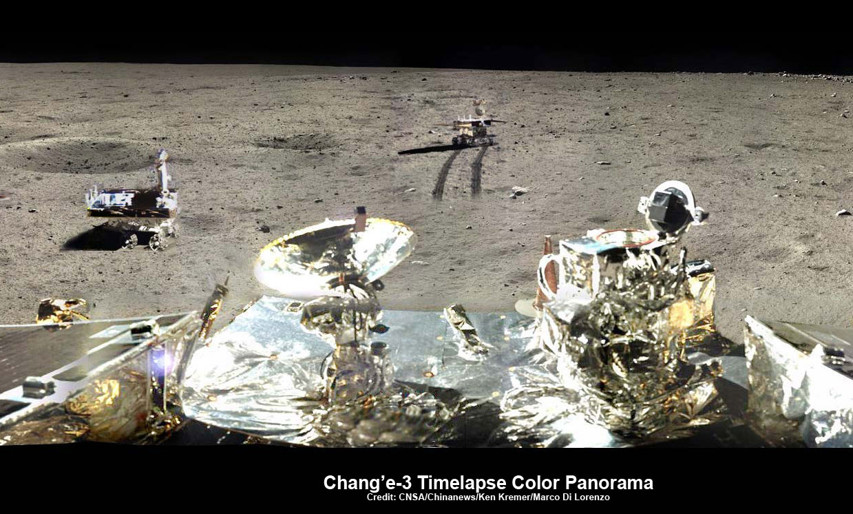
360-degree time-lapse color panorama from China’s Chang’e-3 lander. This new 360-degree time-lapse color panorama from China’s Chang’e-3 lander shows the Yutu rover at five different positions, including passing by crater and heading south and away from the Chang’e-3 lunar landing site forever during its trek over the Moon’s surface at its landing site from Dec. 15-22, 2013 during the 1st Lunar Day. Credit: CNSA/Chinanews/Ken Kremer/Marco Di Lorenzo – kenkremer.com.  See our Yutu timelapse pano at NASA APOD Feb. 3, 2014: http://apod.nasa.gov/apod/ap140203.htm
360-degree time-lapse color panorama from China’s Chang’e-3 lander
This new 360-degree time-lapse color panorama from China’s Chang’e-3 lander shows the Yutu rover at five different positions, including passing by crater and heading south and away from the Chang’e-3 lunar landing site forever during its trek over the Moon’s surface at its landing site from Dec. 15-22, 2013 during the 1st Lunar Day. Credit: CNSA/Chinanews/Ken Kremer/Marco Di Lorenzo – kenkremer.com. See our Yutu timelapse pano at NASA APOD Feb. 3, 2014: http://apod.nasa.gov/apod/ap140203.htm

Yutu first encountered a serious technical malfunction a month ago on Jan. 25, when she suffered ‘a mechanical control anomoly’ just prior to entering hibernation for the duration of Lunar Night 2.

The abnormality occurred due to the “complicated lunar surface,” according to SASTIND.
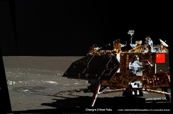
Mosaic of the Chang'e-3 moon lander and the lunar surface taken by the camera on China’s Yutu moon rover from a position south of the lander.   Note the landing ramp and rover tracks at left.  Credit: CNSA/SASTIND/Xinhua/Marco Di Lorenzo/Ken Kremer
Chang’e-3 lander from Yutu moon rover
New mosaic of the Chang’e-3 moon lander and the lunar surface taken by the camera on China’s Yutu moon rover from a position south of the lander. Note the landing ramp and rover tracks at left. Credit: CNSA/SASTIND/Xinhua/Marco Di Lorenzo/Ken Kremer – kenkremer.com

Chinese space officials have not divulged the exact nature of the problems. And they have not released any details of the efforts to resolve the issues that “might cripple the vehicle.”

Since both Chinese Moon probes are solar powered, they must power down and enter a dormant mode during every two week long lunar night period when there is no sunlight to generate energy from their solar arrays. And no communications with Earth are possible.

The rover, nicknamed ‘Jade Rabbit’ remained stationary during the just concluded two week long lunar day time period, said SASTIND. It was unable to move due to the mechanical glitches.

“Yutu only carried out fixed point observations during its third lunar day.”

But it did complete some limited scientific observations. And fortunately the ground penetrating radar, panoramic and infrared imaging equipment are functioning normally.
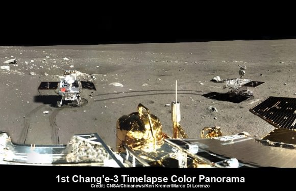
This time-lapse color panorama from China’s Chang’e-3 lander shows the Yutu rover at two different positions during its trek over the Moon’s surface at its landing site from Dec. 15-18, 2013. This view was taken from the 360-degree panorama. Credit: CNSA/Chinanews/Ken Kremer/Marco Di Lorenzo.   See our complete Yutu timelapse pano at NASA APOD Feb. 3, 2014:  http://apod.nasa.gov/apod/ap140203.htm
This time-lapse color panorama from China’s Chang’e-3 lander shows the Yutu rover at two different positions during its trek over the Moon’s surface at its landing site from Dec. 15-18, 2013. This view was taken from the 360-degree panorama. Credit: CNSA/Chinanews/Ken Kremer/Marco Di Lorenzo. See our complete Yutu timelapse pano herein and at NASA APOD Feb. 3, 2014: http://apod.nasa.gov/apod/ap140203.htm

The six wheel robot’s future was placed in jeopardy after it suffered the “mechanical anomaly” in late January 2014 and then awoke later than the scheduled time on Feb. 10, at the start of its 3rd Lunar Day.

To the teams enormous relief, a signal was finally detected.

“Yutu has come back to life!” said Pei Zhaoyu, the spokesperson for China’s lunar probe program, according to a Feb. 12 news report by the state owned Xinhua news agency.

“Experts are still working to verify the causes of its mechanical control abnormality.”

360-degree time-lapse color panorama from China’s Chang’e-3 lander This 360-degree time-lapse color panorama from China’s Chang’e-3 lander shows the Yutu rover at three different positions during its trek over the Moon’s surface at its landing site from Dec. 15-22, 2013 during the 1st Lunar Day. Credit: CNSA/Chinanews/Ken Kremer/Marco Di Lorenzo – kenkremer.com.  See our Yutu timelapse pano at NASA APOD Feb. 3, 2014: http://apod.nasa.gov/apod/ap140203.htm
360-degree time-lapse color panorama from China’s Chang’e-3 lander
This 360-degree time-lapse color panorama from China’s Chang’e-3 lander shows the Yutu rover at three different positions during its trek over the Moon’s surface at its landing site from Dec. 15-22, 2013 during the 1st Lunar Day. Credit: CNSA/Chinanews/Ken Kremer/Marco Di Lorenzo – kenkremer.com. See our Yutu timelapse pano at NASA APOD Feb. 3, 2014: http://apod.nasa.gov/apod/ap140203.htm

Since then, Chinese space engineers sought to troubleshoot the technical problems and were in a race against time to find a solution before the start of Lunar Night 3 this weekend.

“Experts had feared that it might never function again, but Yutu “woke up” on Feb. 12, two days behind schedule,” reported Xinhua.

Each lunar day and night lasts for alternating periods of 14 Earth days.

During each long night, the Moon’s temperatures plunge dramatically to below minus 180 Celsius, or minus 292 degrees Fahrenheit.

Both solar powered probes must enter hibernation mode during each lunar night to conserve energy and protect their science instruments and control mechanisms, computers and electronics.

“Scientists are still trying to find a fix for the abnormalities,” said CCTV, China’s official state television network.

So Yutu is now sleeping with the problems unresolved and no one knows what the future holds.

Hopefully Jade Rabbit awakes again in about two weeks time to see the start of Lunar Day 4.

The Chang’e-3 mothership lander and piggybacked Yutu surface rover soft landed on the Moon on Dec. 14, 2013 at Mare Imbrium (Sea of Rains) – marking China’s first successful spacecraft landings on an extraterrestrial body in history.

Snow Moon 2014 showing where China’s Yutu rover lives and works on lunar surface, at upper left.  Photo: Mark Usciak.  Annotation: Ken Kremer
Snow Moon 2014 showing where China’s Yutu rover lives and works on lunar surface, at upper left. Photo: Mark Usciak. Annotation: Ken Kremer

‘Jade Rabbit’ had departed the landing site forever, and was journeying southwards as the anomoly occurred – about six weeks into its planned 3 month long moon roving expedition to investigate the moon’s surface composition and natural resources.

The 140 kg Yutu robot is located some 100 m south of the lander.

The 1200 kg stationary lander is expected to return science data about the Moon and conduct telescopic observations of the Earth and celestial objects for at least one year.

Chang’e-3 and Yutu landed on a thick deposit of volcanic material.
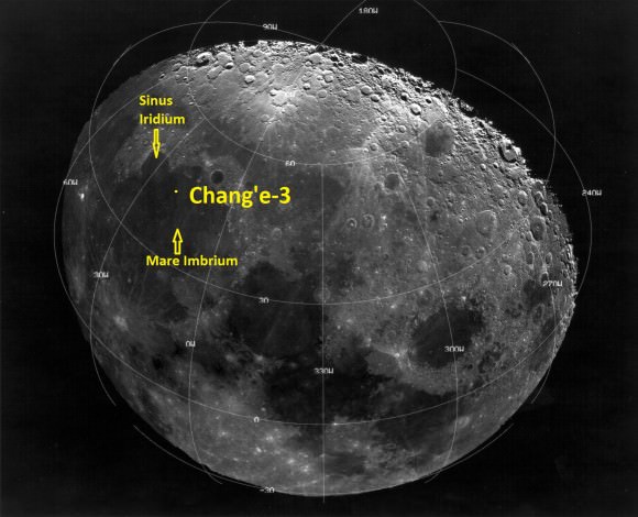
Landing site of Chinese lunar probe Chang'e-3 on Dec. 14, 2013.
Landing site of Chinese lunar probe Chang’e-3 on Dec. 14, 2013.

China is only the 3rd country in the world to successfully soft land a spacecraft on Earth’s nearest neighbor after the United States and the Soviet Union.

Stay tuned here for Ken’s continuing Chang’e-3, Orion, Orbital Sciences, SpaceX, commercial space, LADEE, Mars and more planetary and human spaceflight news.
Ken Kremer

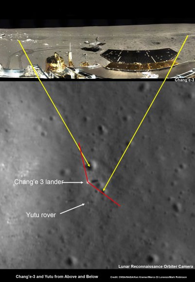
Chang’e-3 lander and Yutu rover – from Above And Below  Composite view shows China’s Chang’e-3 lander and Yutu rover from Above And Below (orbit and surface) – lander color panorama (top) and orbital view from NASA’s LRO orbiter (bottom). Chang’e-3 lander color panorama shows Yutu rover after it drove down the ramp to the moon’s surface and began driving around the landers right side to the south. Yellow lines connect craters seen in the lander panorama and the LROC image from LRO (taken at a later date after the rover had moved), red lines indicate approximate field of view of the lander panorama. Credit: CNSA/NASA/Ken Kremer/Marco Di Lorenzo/Mark Robinson
Chang’e-3 lander and Yutu rover – from Above And Below Composite view shows China’s Chang’e-3 lander and Yutu rover from Above And Below (orbit and surface) – lander color panorama (top) and orbital view from NASA’s LRO orbiter (bottom). Chang’e-3 lander color panorama shows Yutu rover after it drove down the ramp to the moon’s surface and began driving around the landers right side to the south. Yellow lines connect craters seen in the lander panorama and the LROC image from LRO (taken at a later date after the rover had moved), red lines indicate approximate field of view of the lander panorama. Credit: CNSA/NASA/Ken Kremer/Marco Di Lorenzo/Mark Robinson
Traverse Path of Yutu rover from Dec. 14 landing to Dec. 21. Landscape textured with Chang'e 3 imagery from space and ground.  Credit: CNSA/BACC
Traverse Path of Yutu rover from Dec. 14 landing to Dec. 21. Landscape textured with Chang’e 3 imagery from space and ground. Credit: CNSA/BACC

Powerful New Next-Gen US/Japan GPM Satellite to Revolutionize Global Precipitation Observations and Climate Science Research

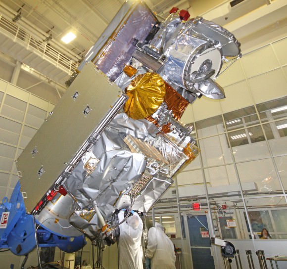
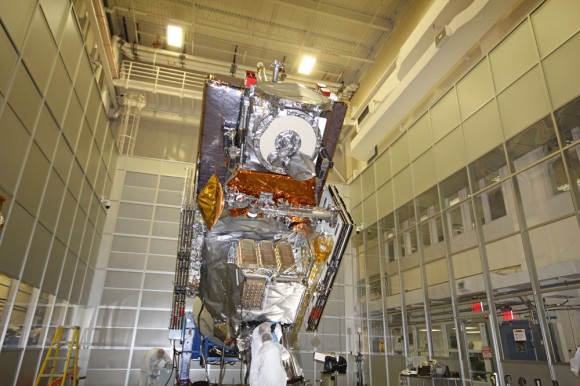
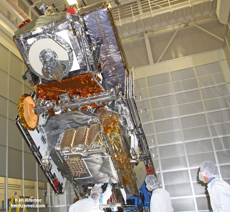
NASA’s next generation Global Precipitation Measurement (GPM) observatory inside the clean room at NASA Goddard Space Flight Center, MD. Technicians at work on final processing during exclusive up-close inspection tour by Universe Today. GPM is slated to launch on February 27, 2014 and will provide global measurements of rain and snow every 3 hours. Credit: Ken Kremer/kenkremer.com

NASA GODDARD SPACE FLIGHT CENTER, MARYLAND – Weather researchers and forecasters worldwide are gushing with excitement in the final days leading to blastoff of the powerful, new Global Precipitation Measurement (GPM) Core Observatory – built by NASA in a joint effort with Japan.

GPM is a next-generation satellite that will provide global, near real time observations of rain and snow from space and thereby open a new revolutionary era in global weather observing and climate science. Therefore it will have a direct impact on society and people’s daily lives worldwide.

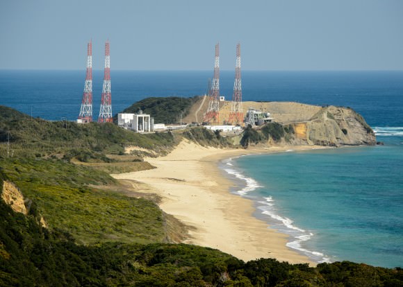
The team is counting down to liftoff in less than 5 days, on Feb. 27 at 1:07 PM EST from the Tanegashima Space Center, on Tanegashima Island off southern Japan, atop the highly reliable Mitsubishi Heavy Industries H-IIA rocket.

The GPM launch to low Earth orbit was delayed by both natural and manmade disasters – namely the 2011 Fukushima earthquake in Japan as well as the ridiculous US government shutdown in Oct. 2013. That’s the same foolish shutdown that also delayed NASA’s new MAVEN Mars orbiter and numerous other US space & science projects.

Visualization of the GPM Core Observatory satellite orbiting the planet earth.  Credit: NASA Goddard
Visualization of the GPM Core Observatory satellite orbiting the planet earth. Credit: NASA Goddard

The $933 Million mission is a joint venture between NASA and the Japan Aerospace Exploration Agency (JAXA), Japan’s space agency.

The mission will significantly advance our understanding of Earth’s water and energy cycles and improve forecasting of extreme weather events.

It is equipped with an advanced, higher resolution dual -frequency precipitation (DPR) radar instrument (Ku and Ka band) built by JAXA in Japan and the GPM microwave imager (GMI) built by Ball Aerospace in the US.

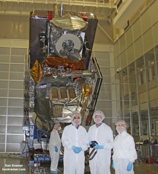
“The GPM satellite was built in house at NASA’s Goddard Space Flight Center in Maryland,” Art Azarbarzin, GPM project manager, told Universe Today during my exclusive up-close clean room inspection tour of the huge satellite as final processing was underway.

Global Precipitation Management Measurement (GPM) observatory satellite inside the clean room at NASA Goddard Space Flight Center undergoes final processing - side view. Credit: Ken Kremer/kenkremer.com
Global Precipitation Measurement (GPM) observatory satellite inside the clean room at NASA Goddard Space Flight Center undergoes final processing – side view. Credit: Ken Kremer/kenkremer.com

Shortly after my tour of GPM, the 3850 kilogram satellite was carefully packed up for shipment to the Japanese launch site.

“GPM will join a worldwide constellation of current and planned satellites,” Azarbarzin told me during an interview in the Goddard cleanroom with GPM.

gpm-decal-smallAnd the imminent launch to augment the existing satellite constellation can’t come soon enough, he noted.

The GPM observatory will replace the aging NASA/JAXA Tropical Rainfall Measuring Mission (TRMM), satellite launched back in 1997.

“GPM is the direct follow-up to the currently orbiting TRMM satellite,” Azarbarzin explained.

“TRMM is reaching the end of its usable lifetime. GPM launches on February 27, 2014 and we hope it has some overlap with observations from TRMM.”

“The Global Precipitation Measurement (GPM) observatory will provide high resolution global measurements of rain and snow every 3 hours,” Dalia Kirschbaum, GPM research scientist, told me during an interview at Goddard.

NASA’s next generation Global Precipitation Measurement (GPM) observatory inside the clean room at NASA Goddard Space Flight Center, MD. Technicians at work on final processing during exclusive up-close inspection tour by Universe Today.  GPM is slated to launch on February 27, 2014 and will provide global measurements of rain and snow every 3 hours. Credit: Ken Kremer/kenkremer.com
NASA’s next generation Global Precipitation Measurement (GPM) observatory inside the clean room at NASA Goddard Space Flight Center, MD. Technicians at work on final processing during exclusive up-close inspection tour by Universe Today. GPM is slated to launch on February 27, 2014 and will provide global measurements of rain and snow every 3 hours. Credit: Ken Kremer/kenkremer.com

It is vital to continuing the TRMM measurements and will help provide improved forecasts and advance warning of extreme super storms like Hurricane Sandy and Super Typhoon Haiyan, Azarbarzin and Kirschbaum explained.

Researchers will use the GPM measurements to study climate change, freshwater resources, floods and droughts, and hurricane formation and tracking.

“The water-cycle, so familiar to all school-age young scientists, is one of the most interesting, dynamic, and important elements in our studies of the Earth’s weather and climate,” said John Grunsfeld, associate administrator for NASA’s Science Mission Directorate in Washington, in a statement.

“GPM will provide scientists and forecasters critical information to help us understand and cope with future extreme weather events and fresh water resources.”

Tanegashima Space Center, on Tanegashima Island off southern Japan
GPM satellite launch site at Tanegashima Space Center, Tanegashima Island, Japan. Credit: NASA

NASA TV will carry the launch live with commentary starting at 12 Noon EST on Feb. 27.

Stay tuned here for Ken’s continuing GPM reports and onsite coverage at NASA Goddard Space Flight Center in Maryland.

And watch for Ken’s continuing planetary and human spaceflight news about Curiosity, Opportunity, Chang’e-3, SpaceX, Orbital Sciences, LADEE, MAVEN, MOM, Mars, Orion and more.

Ken Kremer

NASA/JAXA Global Precipitation Measurement (GPM) satellite inside the clean room at NASA Goddard Space Flight Center, MD, undergoes final processing during exclusive up-close inspection tour by Universe Today:   Dr. Art Azarbarzin/NASA GPM project manager, Dr. Ken Kremer/Universe Today and Dr. Dalia Kirschbaum/NASA GPM research scientist.    Credit: Ken Kremer/kenkremer.com
NASA/JAXA Global Precipitation Measurement (GPM) satellite inside the clean room at NASA Goddard Space Flight Center, MD, undergoes final processing during exclusive up-close inspection tour by Universe Today: Dr. Art Azarbarzin/NASA GPM project manager, Dr. Ken Kremer/Universe Today and Dr. Dalia Kirschbaum/NASA GPM research scientist. Credit: Ken Kremer/kenkremer.com

Dale Gardner, Astronaut Who Rescued A Satellite With A Jetpack, Dead At 65

Dale Gardner (left) prior to the launch of STS-8 in 1983, along with the rest of his crew. Moving left, Guy Bluford, Bill Thornton, Daniel Brandenstein and Dick Truly. Credit: NASA

When Dale Gardner smiled for this preflight picture somewhere around 1983, there was another mission on his horizon: picking up a broken satellite … using a jet backpack. And while we believe that all astronauts have an element of derring-do to them, strapping on a device to bring you away from the shuttle’s safety must have taken a special kind of confidence in your equipment.

Gardner, who died Wednesday (Feb. 18) of a brain aneurysm at the age of 65, was one of a handful of astronauts who used the Manned Maneuvering Unit. In his case, it was to retrieve the malfunctioning Westar 6 satellite. Listen to his account of the story (around 9:25 here), however, and you’ll hear a man more focused on favorable sun angles and learning from the experience of another crewmate on STS-51A.

“I essentially just had a lot of fun on Flight Day 7,” he said in the video. And as the sequence of pictures below shows you, technical as the procedure was, the view must have been breathtaking.

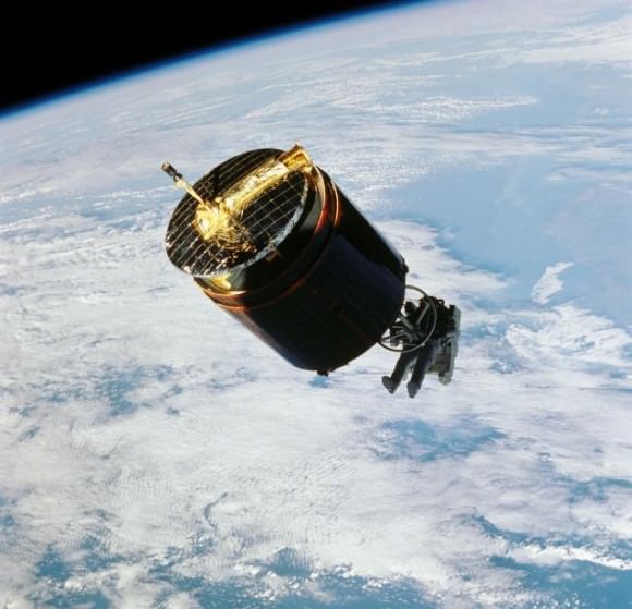
Sequence of images showing NASA astronaut Dale Gardner approaching and capturing the malfunctioning Westar 6 satellite in 1984 during STS-51A. Click for a larger version. Credit: NASA (images) / Elizabeth Howell (photo combination)

Gardner, who was born in Minnesota, joined the U.S. Navy after graduating from the University of Illinois in 1970. He earned his wings the following year, then made his way through assignments to the prestigious Naval Air Test Center in Patuxent River, Maryland (the training ground for many future astronauts).

There, he participated in the development and evaluation of the Grumman F-14 Tomcat, an aircraft eventually used in Operation Desert Storm in the 1990s, among many other missions. Gardner was in fact part of the first F-14 squadron from none other than the USS Enterprise (the aircraft carrier, not the Star Trek ship.)

Gardner came to NASA as part of an immense astronaut class in 1978 that was later known as the “Thirty-Five New Guys” (which, it should be noted, also included six women, a first for the agency). With shuttle flights about to begin — a program that was then expected to launch dozens of flights a year — there appeared to be plenty of room for new recruits. Gardner’s first space-based assignment came upon STS-8, which flew in 1983 to deploy an Indian satellite called Insat-1B.

But it was for STS-51A’s eight-day mission in November 1984 where Gardner will be best remembered, because he did this:

NASA astronaut Dale Gardner captures the malfunctioning Westar 6 satellite during STS-51A in 1984. Gardner was using the Manned Maneuvering Unit, a sort of space backpack that was discontinued for astronaut use after the Challenger explosion of 1986. Credit: NASA

The shuttle mission was packed with satellite activity, with crew members deploying the Canadian communications satellite Anik D2, and U.S. defense communications satellite Leasat-1. Then it was time to pick up a couple of broken satellites to haul back to Earth.

Using a sort of grapple tool and his MMU, Joe Allen successfully retrieved Palapa-B2 on Flight Day 5. After Allen told his crewmates that he had some trouble with the sun in his eyes, Gardner used that information on his own MMU trip to pick up Westar 6 two days later. Specifically, Gardner and the crew had him approach in such a way that the shadow of the satellite fell across the astronaut, stopping the sun glare from becoming a problem.

NASA astronaut Dale Gardner holds a "For Sale" sign during STS-51A in 1984, referring to two satellites captured and retrieved on that mission. Credit: NASA
NASA astronaut Dale Gardner holds a “For Sale” sign during STS-51A in 1984, referring to two satellites captured and retrieved on that mission. Credit: NASA

Both satellites had been in improper orbits due to problems with motors, but Gardner and his crew nabbed them safely for a return back to Earth, allowing insurers to resell the satellites for separate launches in 1990. But Gardner had a parting gotcha before handing them back: he held up a “For Sale” sign that you’ve likely seen reprinted somewhere, as it’s among the most famous shots of the shuttle program.

Gardner returned to the Navy in October 1986 (almost a year after the shuttle Challenger explosion), where he joined U.S. Space Command and held several senior positions. He retired from the Navy in 1990 to work in the private sector.

His death this week from a brain aneurysm was said to be sudden, and prompted a Twitter comment from the Association of Space Explorers saying that it was “devastating news.”

Martian Dune Buggy Curiosity Adopts New Driving Mode to Save Wheels from Rough Rocks

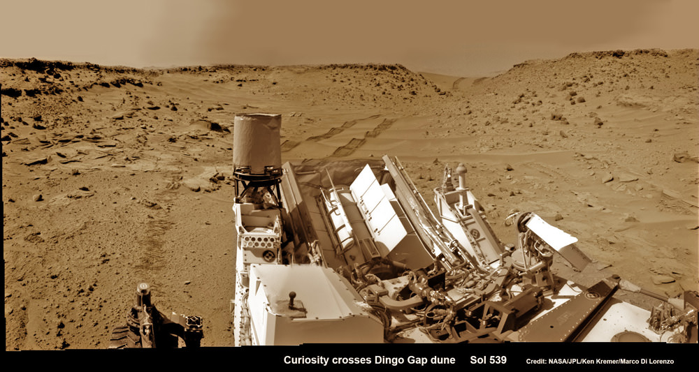
Curiosity looks back eastward to ‘Dingo Gap’ sand dune inside Gale Crater. After crossing over the 3 foot (1 meter) tall dune on Sol 539, Feb. 9, 2014 the rover drove westward into the ‘Moonlight Valley’. The parallel rover wheel tracks are 9 feet (2.7 meters) apart. Assembled from Sol 539 colorized navcam raw images. Credit: NASA/JPL/ Ken Kremer- kenkremer.com/Marco Di Lorenzo

Curiosity looks back eastward to ‘Dingo Gap’ sand dune inside Gale Crater
After crossing over the 3 foot (1 meter) tall dune on Sol 539, Feb. 9, 2014 the rover drove westward into the ‘Moonlight Valley’. The parallel rover wheel tracks are 9 feet (2.7 meters) apart. Assembled from Sol 539 colorized navcam raw images. Credit: NASA/JPL/ Ken Kremer- kenkremer.com/Marco Di Lorenzo
See Dune and Wheel mosaics below – Story updated [/caption]

The team directing the epic trek of NASA’s Curiosity rover across the floor of Gale Crater has adopted new driving strategies and a new way forward in response to the unexpected wheel damage caused by driving over fields of rough edged Red Planet rocks in recent months.

This week, engineers directed dune buggy Curiosity to drive backwards for a lengthy distance over the Martian surface for the first time since landing.

The SUV sized vehicle apparently passed the reverse driving feasibility test with flying colors and is now well on the way to the exciting journey ahead aiming for the sedimentary layers at the base of towering Mount Sharp – the primary mission destination – which reaches 3.4 miles (5.5 km) into the Martian sky and possesses water altered minerals.

“We wanted to have backwards driving in our validated toolkit because there will be parts of our route that will be more challenging,” said Curiosity Project Manager Jim Erickson of NASA’s Jet Propulsion Laboratory, Pasadena, Calif, in a statement.

On Tuesday, Feb. 18, Curiosity not only drove in reverse, but the 329 feet (100.3 meters) distance covered marked her farthest one-day advance in over three months.

And she is also now roving over the much sought after smoother Martian terrain, as hoped, when the team decided to alter the traverse route based on high resolution imaging observations collected by the telescopic camera on NASA’s Mars Reconnaissance Orbiter (MRO) circling overhead.

The goal is to minimize wear and tear on the 20 inch diameter wheels.

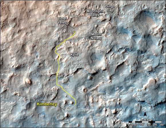
This map shows the route driven and route planned for NASA's Curiosity Mars rover from before reaching "Dingo Gap" -- in upper right -- to the mission's next science waypoint, "Kimberley" (formerly referred to as "KMS-9") -- in lower left.   Credit: NASA/JPL-Caltech/Univ. of Arizona
This map shows the route driven and route planned for NASA’s Curiosity Mars rover from before reaching “Dingo Gap” — in upper right — to the mission’s next science waypoint, “Kimberley” (formerly referred to as “KMS-9”) — in lower left. Credit: NASA/JPL-Caltech/Univ. of Arizona

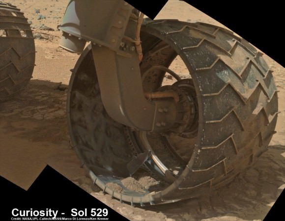
Engineers were forced to devise new driving techniques and consider a new route forward after the aluminum wheels accumulated significant punctures and rips during the past few months of driving over fields strewn with sharp edged Martian rocks.

“We have changed our focus to look at the big picture for getting to the slopes of Mount Sharp, assessing different potential routes and different entry points to the destination area,” Erickson said.

“No route will be perfect; we need to figure out the best of the imperfect ones.”

But to reach the smooth terrain and the science rich targets located on the pathway ahead, the six wheeled rover first had to pass through a gateway known as the ‘Dingo Gap’ sand dune.

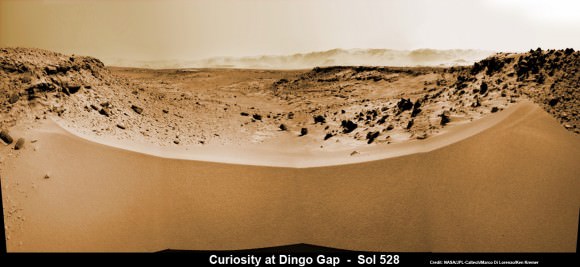
Curiosity’s View Past Tall Dune at edge of ‘Dingo Gap’  This photomosaic from Curiosity’s Navigation Camera (Navcam) taken at the edge of the entrance to the Dingo Gap shows a 3 foot (1 meter) tall dune and valley terrain beyond to the west, all dramatically back dropped by eroded rim of Gale Crater. View from the rover’s current position on Sol 528 (Jan. 30, 2014). The rover team may decide soon whether Curiosity will bridge the dune gap as a smoother path to next science destination. Credit: NASA/JPL-Caltech/Marco Di Lorenzo/Ken Kremer- kenkremer.com
Curiosity’s View Past Tall Dune at edge of ‘Dingo Gap’
This photomosaic from Curiosity’s Navigation Camera (Navcam) taken at the edge of the entrance to the Dingo Gap shows a 3 foot (1 meter) tall dune and valley terrain beyond to the west, all dramatically back dropped by eroded rim of Gale Crater. View from the rover’s current position on Sol 528 (Jan. 30, 2014). The rover team may decide soon whether Curiosity will bridge the dune gap as a smoother path to next science destination. Credit: NASA/JPL-Caltech/Marco Di Lorenzo/Ken Kremer- kenkremer.com

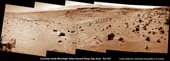
“Moonlight Valley” is the name of the breathtaking new locale beyond Dingo, Curiosity Principal Investigator John Grotzinger, of Caltech, told Universe Today.

Curiosity crossed through the 3 foot (1 meter) tall Dingo Gap sand dune with ease on Feb. 9 and roved on to targets in the “Moonlight Valley” and the region beyond.

“Moonlight Valley has got lots of veins cutting through it,” Grotzinger told me.

“We’re seeing recessive bedrock.”

Curiosity scans Moonlight Valley beyond Dingo Gap Dune. Curiosity’s view to “Moonlight Valley” beyond after crossing over ‘Dingo Gap’ sand dune. This photomosaic was taken after Curiosity drove over the 1 meter tall Dingo Gap sand dune and shows dramatic scenery in the valley beyond, back dropped by eroded rim of Gale Crater. Assembled from navigation camera (navcam) raw images from Sol 535 (Feb. 6, 2104) Credit: NASA/JPL-Caltech/Ken Kremer- kenkremer.com/Marco Di Lorenzo

Since passing through the Dingo Gap gateway, Curiosity has traveled another 937 feet (285.5 meters) for a total mission odometry of 3.24 miles (5.21 kilometers) since the nail biting landing on Aug. 6, 2012.

“After we got over the dune, we began driving in terrain that looks like what we expected based on the orbital data. There are fewer sharp rocks, many of them are loose, and in most places there’s a little bit of sand cushioning the vehicle,” Erickson said.

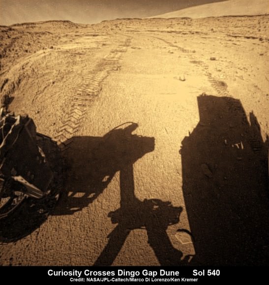
Curiosity looks back to ‘Dingo Gap’ sand dune after crossing over, backdropped by Mount Sharp on Sol 540, Feb. 12, 2014.  Rear hazcam fisheye image linearized and colorized.  Credit: NASA/JPL/Marco Di Lorenzo/Ken Kremer- kenkremer.com
Curiosity looks back to ‘Dingo Gap’ sand dune after crossing over, backdropped by Mount Sharp on Sol 540, Feb. 12, 2014. Rear hazcam fisheye image linearized and colorized. Credit: NASA/JPL/Marco Di Lorenzo/Ken Kremer- kenkremer.com

Curiosity’s near term goal is to reach her next science waypoint, named Kimberly (formerly called KMS-9) which lies about two-thirds of a mile (about 1.1 kilometers) ahead.

Kimberly is of interest to the science team because it sits at an the intersection of different rock layers.

The 1 ton robot may be directed to drill into another rock at Kimberly.

If approved, Kimberly would be her first since drilling operation since boring into Cumberland rock target last spring and since departing the Yellowknife Bay region in July 2013 where she discovered a habitable zone.

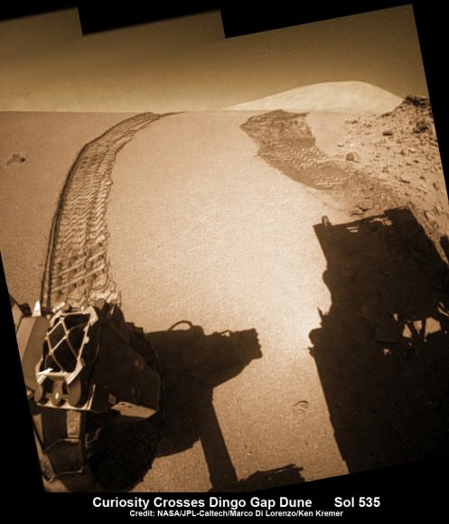
Curiosity looks back to ‘Dingo Gap’ sand dune after crossing over, backdropped by Mount Sharp on Sol 535, Feb. 5, 2014.  Hazcam fisheye image linearized and colorized.  Credit: NASA/JPL/Marco Di Lorenzo/Ken Kremer- kenkremer.
Curiosity looks back to ‘Dingo Gap’ sand dune after crossing over, backdropped by Mount Sharp on Sol 535, Feb. 5, 2014. Hazcam fisheye image linearized and colorized. Credit: NASA/JPL/Marco Di Lorenzo/Ken Kremer- kenkremer

To date Curiosity’s odometer stands at 5.2 kilometers and she has taken over 118,000 images. The robot has about another 5 km to go to reach the foothills of Mount Sharp.

Meanwhile, NASA’s sister Opportunity rover was just imaged from orbit by MRO while exploring clay mineral outcrops by the summit of Solander Point on the opposite side of Mars at the start of her 2nd Decade investigating the Red Planet’s mysteries.

And a pair of new orbiters are streaking to the Red Planet to fortify Earth’s invasion fleet- NASA’s MAVEN and India’s MOM.

Stay tuned here for Ken’s continuing Curiosity, Opportunity, Chang’e-3, SpaceX, Orbital Sciences, LADEE, MAVEN, MOM, Mars and more planetary and human spaceflight news.

Ken Kremer

Up close photomosaic view shows lengthy tear in rover Curiosity’s left front wheel caused by recent driving over sharp edged Martian rocks on the months long trek to Mount Sharp. Raw images taken by the MAHLI camera on Curiosity’s arm on Jan. 31, 2014 (Sol 529) were assembled to show some recent damage to several of its six wheels   Credit: NASA / JPL / MSSS / Marco Di Lorenzo / Ken Kremer- kenkremer.com  See below complete 6 wheel mosaic and further wheel mosaics for comparison
Up close photomosaic view shows lengthy tear in rover Curiosity’s left front wheel caused by recent driving over sharp edged Martian rocks on the months long trek to Mount Sharp. Raw images taken by the MAHLI camera on Curiosity’s arm on Jan. 31, 2014 (Sol 529) were assembled to show some recent damage to several of its six wheels Credit: NASA / JPL / MSSS / Marco Di Lorenzo / Ken Kremer- kenkremer.com

Opportunity rover Spied atop Martian Mountain Ridge from Orbit – Views from Above and Below

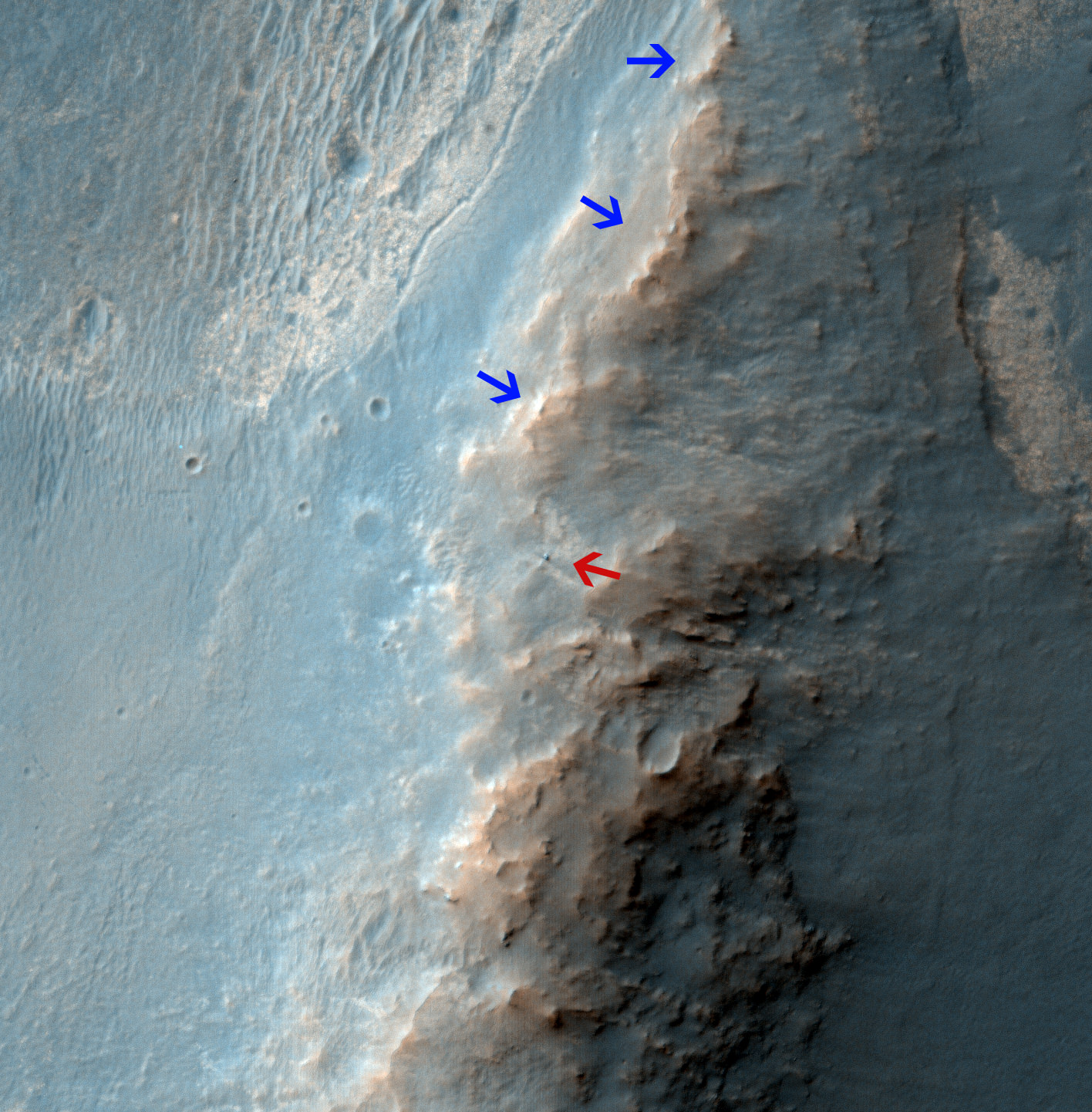
Opportunity Rover on 'Murray Ridge' Seen From Orbit on Valentine’s Day 2014 . The telescopic High Resolution Imaging Science Experiment (HiRISE) camera on NASA's Mars Reconnaissance Orbiter caught this view of NASA's Mars Exploration Rover Opportunity on Feb. 14, 2014 by the summit of Solander Point. The red arrow points to Opportunity at the center of the image. Blue arrows point to tracks left by the rover since it entered the area seen here, in October 2013. The scene covers a patch of ground about one-quarter mile (about 400 meters) wide. North is toward the top. The location is the "Murray Ridge" section of the western rim of Endeavour Crater. Credit: NASA/JPL-Caltech/Univ. of Arizona

Opportunity Rover on ‘Murray Ridge’ Seen From Orbit on Valentine’s Day 2014
The telescopic High Resolution Imaging Science Experiment (HiRISE) camera on NASA’s Mars Reconnaissance Orbiter caught this view of NASA’s Mars Exploration Rover Opportunity on Feb. 14, 2014 by the summit of Solander Point. The red arrow points to Opportunity at the center of the image. Blue arrows point to tracks left by the rover since it entered the area seen here, in October 2013. The scene covers a patch of ground about one-quarter mile (about 400 meters) wide. North is toward the top. The location is the “Murray Ridge” section of the western rim of Endeavour Crater. Credit: NASA/JPL-Caltech/Univ. of Arizona
See below corresponding surface view snapped by Opportunity from this location[/caption]

NASA’s renowned Mars rover Opportunity has been spied anew in a fabulous new photo captured just days ago by NASA’s ‘Spy in the Sky’ orbiter circling overhead the Red Planet. See Opportunity from above and below – from today’s location. See orbital view above – just released today.

The highly detailed image was freshly taken on Feb. 14 (Valentine’s Day 2014) by the telescopic High Resolution Imaging Science Experiment (HiRISE) camera on NASA’s Mars Reconnaissance Orbiter (MRO) as the decade old Opportunity was investigating the tasty alien terrain on ‘Murray Ridge’ – nearby the celebrated ‘jelly doughnut’ rock by the summit of Solander Point. See surface views below.

The fabulous orbital image shows not only rover Opportunity at her location today, but also the breathtaking landscape around the robots current location as well as some of the wheel tracks created by the Martian mountaineer as she climbed from the plains below up to near the peak of Solander Point.

The scene is narrowly focused on a spot barely one-quarter mile (400 meters) wide.

Murray Ridge and Solander Point lie at the western rim of a vast crater named Endeavour that spans some 22 kilometers (14 miles) in diameter.

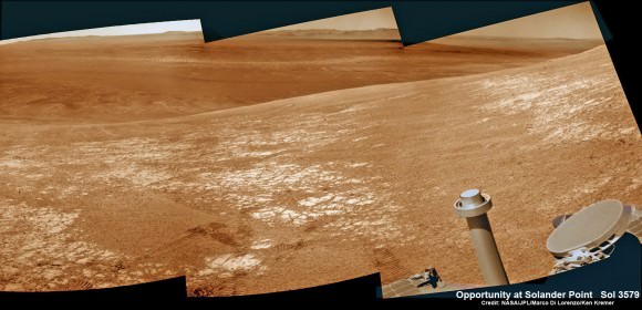
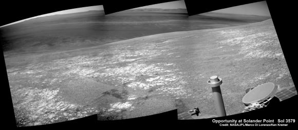
Here is the corresponding Martian surface view snapped by Opportunity on Feb. 16, 2014 (looking back and down to Endeavour crater), while she’s being imaged from Mars orbit on Feb. 14, 2014:

NASA’s Opportunity rover was imaged here from Mars orbit by MRO HiRISE camera on Feb. 14, 2014.  This mosaic shows Opportunity’s view today while looking back to vast Endeavour crater from atop Murray Ridge by summit of Solander Point.  Opportunity captured this photomosaic view on Feb. 16, 2014 (Sol 3579) from the western rim of Endeavour Crater where she is investigating outcrops of potential clay minerals formed in liquid water.  Assembled from Sol 3579 colorized navcam raw images.  Credit: NASA/JPL/Cornell/Marco Di Lorenzo/Ken Kremer-kenkremer.com
NASA’s Opportunity rover was imaged here from Mars orbit by MRO HiRISE camera on Feb. 14, 2014. This mosaic shows Opportunity’s view today while looking back to vast Endeavour crater from atop Murray Ridge by summit of Solander Point. Opportunity captured this photomosaic view on Feb. 16, 2014 (Sol 3579) from the western rim of Endeavour Crater where she is investigating outcrops of potential clay minerals formed in liquid water. Assembled from Sol 3579 colorized navcam raw images. Credit: NASA/JPL/Cornell/Marco Di Lorenzo/Ken Kremer-kenkremer.com

Endeavour is an impact scar created billions of years ago. See our 10 Year Opportunity traverse map below.

And believe it or not, that infamous ‘jelly doughnut’ rock was actually the impetus for this new imaging campaign by NASA’s MRO Martian ‘Spysat.’

To help solve the mystery of the origin of the shiny 1.5 inches wide (4 centimeters) ‘jelly doughnut’ rock, dubbed ‘Pinnacle Island’, the science team decided to enlist the unparalleled capabilities of the HiRISE camera and imaging team in pursuit of answers.

Opportunity by Solander Point peak – 2nd Mars Decade Starts here!  NASA’s Opportunity rover captured this panoramic mosaic on Dec. 10, 2013 (Sol 3512) near the summit of “Solander Point” on the western rim of Endeavour Crater where she starts Decade 2 on the Red Planet. She is currently investigating outcrops of potential clay minerals formed in liquid water on her 1st mountain climbing adventure. Assembled from Sol 3512 navcam raw images. Credit: NASA/JPL/Cornell/Marco Di Lorenzo/Ken Kremer-kenkremer.com
Opportunity by Solander Point peak – 2nd Mars Decade Starts here!
NASA’s Opportunity rover captured this panoramic mosaic on Dec. 10, 2013 (Sol 3512) near the summit of “Solander Point” on the western rim of Endeavour Crater where she starts Decade 2 on the Red Planet. She is currently investigating outcrops of potential clay minerals formed in liquid water on her 1st mountain climbing adventure. Assembled from Sol 3512 navcam raw images. Credit: NASA/JPL/Cornell/Marco Di Lorenzo/Ken Kremer-kenkremer.com

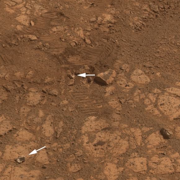
‘Pinnacle Island’ had suddenly appeared out of nowhere in a set of before/after pictures taken by Opportunity’s cameras on Jan, 8, 2014 (Sol 3540), whereas that exact same spot had been vacant of debris in photos taken barely 4 days earlier. And the rover hadn’t budged a single millimeter.

So the HiRISE research team was called in to plan a new high resolution observation of the ‘Murray Ridge’ area and gather clues about the rocky riddle.

The purpose was to “check the remote possibility that a fresh impact by an object from space might have excavated a crater near Opportunity and thrown this rock to its new location”- now known as Pinnacle Island, said NASA in a statement.

Well, no fresh crater impacting site was found in the new image.

“We see no obvious signs of a very recent crater in our image, but a careful comparison to prior images might reveal subtle changes,” wrote HiRISE principal investigator Alfred McEwen in a description today.

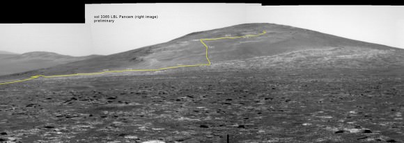
Back on sol 3365 we took this image of Solander Point as we approached it. Here I have plotted the subsequent route that Opportunity has taken in climbing up the ridge. The outcrop shown I the images below are near the end of the yellow traverse line.  Caption and mosaic by Larry Crumpler/NASA/JPL/
Back on sol 3365 we took this image of Solander Point as we approached it. Here I have plotted the subsequent route that Opportunity has taken in climbing up the ridge. The outcrop shown I the images below are near the end of the yellow traverse line. Caption and mosaic by Larry Crumpler/NASA/JPL/

In the meantime, as I reported here a few days ago the mystery was solved at last by the rover team after Opportunity drove a short distance away from the ‘jelly doughnut’ rock and snapped some ‘look back’ photographs to document the ‘mysterious scene’ for further scrutiny.

It turns out that the six wheeled Opportunity unknowingly ‘created’ the mystery herself when she drove over a larger rock, crushing and breaking it apart with the force from the wheels and her hefty 400 pound (185 kg) mass.

“Once we moved Opportunity a short distance, after inspecting Pinnacle Island, we could see directly uphill an overturned rock that has the same unusual appearance,” said Opportunity Deputy Principal Investigator Ray Arvidson of Washington University in St. Louis, in a NASA statement.

“Murray Ridge” and the Solander Point mountaintop are of great scientific interest because the region is riven with outcrops of minerals, including clay minerals, that likely formed in flowing liquid neutral water conducive to life – potentially a scientific goldmine.

Today, Feb 19, marks Opportunity’s 3582nd Sol or Martian Day roving Mars. She is healthy with plenty of power.

So far she has snapped over 188,800 amazing images on the first overland expedition across the Red Planet.

Her total odometry stands at over 24.07 miles (38.73 kilometers) since touchdown on Jan. 24, 2004 at Meridiani Planum.

Opportunity by Solander Point peak – 2nd Mars Decade Starts here!  NASA’s Opportunity rover captured this panoramic mosaic on Dec. 10, 2013 (Sol 3512) near the summit of “Solander Point” on the western rim of vast Endeavour Crater where she starts Decade 2 on the Red Planet. She is currently investigating summit outcrops of potential clay minerals formed in liquid water on her 1st mountain climbing adventure. See wheel tracks at center and dust devil at right. Assembled from Sol 3512 navcam raw images. Credit: NASA/JPL/Cornell/Marco Di Lorenzo/Ken Kremer-kenkremer.com
Opportunity by Solander Point peak – 2nd Mars Decade Starts here!
NASA’s Opportunity rover captured this panoramic mosaic on Dec. 10, 2013 (Sol 3512) near the summit of “Solander Point” on the western rim of vast Endeavour Crater where she starts Decade 2 on the Red Planet. She is currently investigating summit outcrops of potential clay minerals formed in liquid water on her 1st mountain climbing adventure. See wheel tracks at center and dust devil at right. Assembled from Sol 3512 navcam raw images. Credit: NASA/JPL/Cornell/Marco Di Lorenzo/Ken Kremer-kenkremer.com

Read more about sister Spirit – here and here.

Meanwhile on the opposite side of Mars, Opportunity’s younger sister rover Curiosity is trekking towards gigantic Mount Sharp and just crested over the Dingo Gap sand dune. She celebrated 500 Sols on Mars on New Years Day 2014.

And a pair of new orbiters are streaking to the Red Planet to fortify Earth’s invasion fleet- NASA’s MAVEN and India’s MOM.

Finally, China’s Yutu rover has awoken for her 3rd workday on the Moon.

Stay tuned here for Ken’s continuing Opportunity, Curiosity, Chang’e-3, LADEE, MAVEN, Mars rover, MOM and continuing planetary and human spaceflight news.
Ken Kremer

This image from the panoramic camera (Pancam) on NASA’s rover Opportunity shows the location of a rock called "Pinnacle Island" before it appeared in front of the rover in early January 2014.  Arrow at lower left. This image was taken during Sol 3567 of Opportunity's work on Mars (Feb. 4, 2014).  Credit:  NASA/JPL-Caltech/Cornell Univ./Arizona State Univ.
This image from the panoramic camera (Pancam) on NASA’s rover Opportunity shows the location of a rock called “Pinnacle Island” before it appeared in front of the rover in early January 2014. Arrow at lower left. This image was taken during Sol 3567 of Opportunity’s work on Mars (Feb. 4, 2014). Credit: NASA/JPL-Caltech/Cornell Univ./Arizona State Univ.
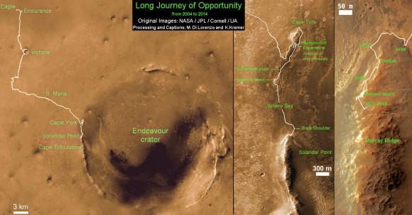
Traverse Map for NASA’s Opportunity rover from 2004 to 2014  This map shows the entire path the rover has driven during a decade on Mars and over 3560 Sols, or Martian days, since landing inside Eagle Crater on Jan 24, 2004 to current location by Solander Point summit at the western rim of Endeavour Crater. Rover will spend 6th winter here atop Solander. Opportunity discovered clay minerals at Esperance – indicative of a habitable zone. Credit: NASA/JPL/Cornell/ASU/Marco Di Lorenzo/Ken Kremer – kenkremer.com
Traverse Map for NASA’s Opportunity rover from 2004 to 2014
This map shows the entire path the rover has driven during a decade on Mars and over 3560 Sols, or Martian days, since landing inside Eagle Crater on Jan 24, 2004 to current location by Solander Point summit at the western rim of Endeavour Crater. Rover will spend 6th winter here atop Solander. Opportunity discovered clay minerals at Esperance – indicative of a habitable zone. Credit: NASA/JPL/Cornell/ASU/Marco Di Lorenzo/Ken Kremer – kenkremer.com
NASA’s Opportunity rover was imaged here from Mars orbit by MRO HiRISE camera on Feb. 14, 2014.  This mosaic shows Opportunity’s view today while looking back to vast Endeavour crater from atop Murray Ridge by summit of Solander Point.  Opportunity captured this photomosaic view on Feb. 16, 2014 (Sol 3579) from the western rim of Endeavour Crater where she is investigating outcrops of potential clay minerals formed in liquid water.  Assembled from Sol 3579 navcam raw images.  Credit: NASA/JPL/Cornell/Marco Di Lorenzo/Ken Kremer-kenkremer.com
NASA’s Opportunity rover was imaged here from Mars orbit by MRO HiRISE camera on Feb. 14, 2014. This mosaic shows Opportunity’s view today while looking back to vast Endeavour crater from atop Murray Ridge by summit of Solander Point. Opportunity captured this photomosaic view on Feb. 16, 2014 (Sol 3579) from the western rim of Endeavour Crater where she is investigating outcrops of potential clay minerals formed in liquid water. Assembled from Sol 3579 navcam raw images. Credit: NASA/JPL/Cornell/Marco Di Lorenzo/Ken Kremer-kenkremer.com

Stars Boil Before They Blow Up, Says NuSTAR

NASA's NuSTAR is revealing the mechanics behind Cassiopeia A's supernova explosion (Image credit: NASA/JPL-Caltech/CXC/SAO)

Supernovas are some of the most energetic and powerful events in the observable Universe. Briefly outshining entire galaxies, they are the final, dying  outbursts of stars several times more massive than our Sun. And while we know supernovas are responsible for creating the heavy elements necessary for everything from planets to people to power tools,  scientists have long struggled to determine the mechanics behind the sudden collapse and subsequent explosion of massive stars.

Now, thanks to NASA’s NuSTAR mission, we have our first solid clues to what happens before a star goes “boom.”

The image above shows the supernova remnant Cassiopeia A (or Cas A for short) with NuSTAR data in blue and observations from the Chandra X-ray Observatory in red, green, and yellow. It’s the shockwave left over from the explosion of a star about 15 to 25 times more massive than our Sun over 330 years ago*, and it glows in various wavelengths of light depending on the temperatures and types of elements present.

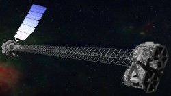
Artist's concept of NuSTAR in orbit. (NASA/JPL-Caltech)
Artist’s concept of NuSTAR in orbit. (NASA/JPL-Caltech)

Previous observations with Chandra revealed x-ray emissions from expanding shells and filaments of hot iron-rich gas in Cas A, but they couldn’t peer deep enough to get a better idea of what’s inside the structure. It wasn’t until NASA’s Nuclear Spectroscopic Telescope Array — that’s NuSTAR to those in the know — turned its x-ray vision on Cas A that the missing puzzle pieces could be found.

And they’re made of radioactive titanium.

Many models have been made (using millions of hours of supercomputer time) to try to explain core-collapse supernovas. One of the leading ones has the star ripped apart by powerful jets firing from its poles — something that’s associated with even more powerful (but focused) gamma-ray bursts. But it didn’t appear that jets were the cause with Cas A, which doesn’t exhibit elemental remains within its jet structures… and besides, the models relying on jets alone didn’t always result in a full-blown supernova.

As it turns out, the presence of asymmetric clumps of radioactive titanium deep within the shells of Cas A, revealed in high-energy x-rays by NuSTAR, point to a surprisingly different process at play: a “sloshing” of material within the progenitor star that kickstarts a shockwave, ultimately tearing it apart.

Watch an animation of how this process occurs:

The sloshing, which occurs over a time span of a mere couple hundred milliseconds — literally in the blink of an eye — is likened to boiling water on a stove. When the bubbles break through the surface, the steam erupts.

Only in this case the eruption leads to the insanely powerful detonation of an entire star, blasting a shockwave of high-energy particles into the interstellar medium and scattering a periodic tableful of heavy elements into the galaxy.

In the case of Cas A, titanium-44 was ejected, in clumps that echo the shape of the original sloshing asymmetry. NuSTAR was able to image and map the titanium, which glows in x-ray because of its radioactivity (and not because it’s heated by expanding shockwaves, like other lighter elements visible to Chandra.)

“Until we had NuSTAR we couldn’t really see down into the core of the explosion,” said Caltech astronomer Brian Grefenstette during a NASA teleconference on Feb. 19.

Illustration of the pre-supernova star in Cassiopeia A. It's thought that its layers were "turned inside out" just before it detonated. (NASA/CXC/M.Weiss)
Illustration of the pre-supernova star in Cassiopeia A. It’s thought that its layers were “turned inside out” just before it detonated. (NASA/CXC/M.Weiss)

“Previously, it was hard to interpret what was going on in Cas A because the material that we could see only glows in X-rays when it’s heated up. Now that we can see the radioactive material, which glows in X-rays no matter what, we are getting a more complete picture of what was going on at the core of the explosion.”

– Brian Grefenstette, lead author, Caltech

Okay, so great, you say. NASA’s NuSTAR has found the glow of titanium in the leftovers of a blown-up star, Chandra saw some iron, and we know it sloshed and ‘boiled’ a fraction of a second before it exploded. So what?

“Now you should care about this,” said astronomer Robert Kirshner of the Harvard-Smithsonian Center for Astrophysics. “Supernovae make the chemical elements, so if you bought an American car, it wasn’t made in Detroit two years ago; the iron atoms in that steel were manufactured in an ancient supernova explosion that took place five billion years ago. And NuSTAR shows that the titanium that’s in your Uncle Jack’s replacement hip were made in that explosion too.

“We’re all stardust, and NuSTAR is showing us where we came from. Including our replacement parts. So you should care about this… and so should your Uncle Jack.”

And it’s not just core-collapse supernovas that NuSTAR will be able to investigate. Other types of supernovas will be scrutinized too — in the case of SN2014J, a Type Ia that was spotted in M82 in January, even right after they occur.

“We know that those are a type of white dwarf star that detonates,” NuSTAR principal investigator Fiona Harrison responded to Universe Today during the teleconference. “This is very exciting news… NuSTAR has been looking at [SN2014J] for weeks, and we hope to be able to say something about that explosion as well.”

Previous imaging with Chandra (left, middle) is combined with new data from NuSTAR (right) to make a complete image of a supernova remnant. (NASA/JPL-Caltech/CXC/SAO)

One of the most valuable achievements of the recent NuSTAR findings is having a new set of observed constraints to place on future models of core-collapse supernovas… which will help provide answers — and likely new questions — about how stars explode, even hundreds or thousands of years after they do.

“NuSTAR is pioneering science, and you have to expect that when you get new results, it’ll open up as many questions as you answer,” said Kirshner.

Launched in June of 2012, NuSTAR is the first focusing hard X-ray telescope to orbit Earth and the first telescope capable of producing maps of radioactive elements in supernova remnants.

Read more on the JPL news release here, and listen to the full press conference here.

*As Cas A resides 11,000 light-years from Earth, the actual date of the supernova would be about 11,330 years ago. Give or take a few.

Private Cygnus Cargo Carrier departs Space Station Complex

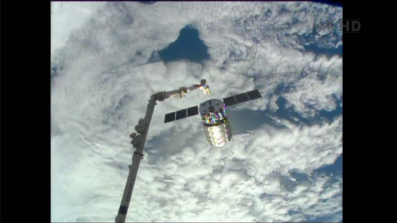
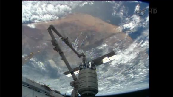
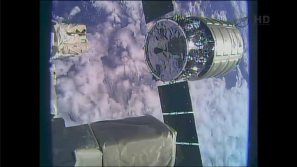
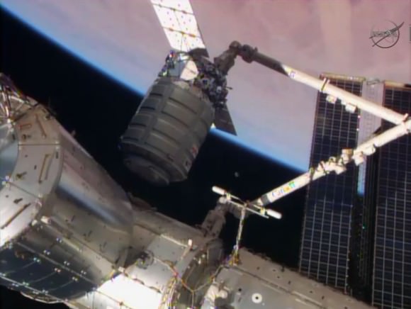
The Cygnus private cargo craft built by Orbital Sciences Corp. was released from the station's robotic arm at 6:41am EST, Feb 18. It will burn up in Earth's atmosphere on Wednesday, Feb. 19, 2014. Credit: NASA TV

Following a picture perfect blastoff from NASA’s frigid Virginia spaceport and a flawless docking at the International Space Station (ISS) in mid-January, the privately built Cygnus cargo resupply vehicle has completed its five week long and initial operational station delivery mission and departed the facility early this morning, Tuesday, Feb. 18.

The Expedition 38 crewmembers Michael Hopkins of NASA and Koichi Wakata of the Japan Aerospace Exploration Agency (JAXA) demated the Orbital Sciences Cygnus commercial spacecraft from the Earth-facing port of the Harmony node using the Canadian built robotic arm at about 5:15 a.m. EST.

The cylindrically shaped ship was released from the grappling snare on the terminus of the 57 foot long extended arm at about 6:41 a.m. EST and with a slight shove as both vehicles were flying at 17500 mph and some 260 miles (415 km) altitude above Earth over the southern tip of Argentina and the South Atlantic Ocean.

The astronauts were working at a robotics work station in the windowed Cupola module facing the Earth. The arm was quickly pulled back about 5 feet (1.5 m) after triggering the release from the grappling pin.

NASA TV carried the operation live. Station and arm cameras provided spectacular video views of the distinctive grey cylindrical Cygnus back dropped by the massive, cloud covered blue Earth as it was released and sped away.

The Cygnus private cargo craft built by Orbital Sciences Corp. was released from the station's robotic arm at 6:41am EST, Feb 18. It will burn up in Earth's atmosphere on Wednesday, Feb. 19, 2014. Credit: NASA TV
The Cygnus private cargo craft built by Orbital Sciences Corp. was released from the station’s robotic arm at 6:41am EST, Feb 18. It will burn up in Earth’s atmosphere on Wednesday, Feb. 19, 2014. Credit: NASA TV

Cygnus was commanded to fire its jets for the departure maneuvers to quickly retreat away from the station. It was barely a speck only 5 minutes after the arm release maneuver by Wakata and Hopkins.

“The departure was nominal,” said Houston mission control. “Cygnus is on its way.”

The solar powered Cygnus is America’s newest commercial space freighter and was built by Orbital Sciences Corporation with seed money from NASA in a public-private partnership aimed at restoring the cargo up mass capabilities lost following the retirement of NASA’s space shuttles in 2011.

Cygnus, as well as the SpaceX Dragon cargo vessel, functions as an absolutely indispensable “lifeline” to keep the massive orbiting outpost alive and humming with the science for which it was designed.

The Cygnus private cargo craft built by Orbital Sciences Corp. was released from the station's robotic arm at 6:41am EST, Feb 18. It will burn up in Earth's atmosphere on Wednesday, Feb. 19, 2014. Credit: NASA TV
The Cygnus private cargo craft built by Orbital Sciences Corp. was released from the station’s robotic arm at 6:41am EST, Feb 18. It will burn up in Earth’s atmosphere on Wednesday, Feb. 19, 2014. Credit: NASA TV

The freighter delivered a treasure trove of 1.5 tons of vital research experiments, crew provisions, two dozen student science projects, belated Christmas presents, fresh fruit and more to the million pound orbiting lab complex and its six man crew.

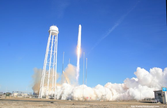
The milestone flight dubbed Orbital 1, or Orb-1, began with the flawless Jan. 9 blast off of Cygnus mounted atop Orbital Sciences’ two stage, private Antares booster on the maiden operational launch from NASA’s Wallops Flight Facility along Virginia’s eastern shore. See a gallery of launch photos and videos – here and here.

“Today’s launch gives us the cargo capability to keep the station going,” said Frank Culbertson, executive vice president and general manager of Orbital’s advanced spaceflight programs group, and former Space Shuttle astronaut.

Antares soars to space on Jan. 9, 2014 from NASA Wallops on Virginia coast on the Orb-1 mission to the ISS.  Photo taken by remote camera at launch pad. Credit: Ken Kremer - kenkremer.com
Antares soars to space on Jan. 9, 2014 from NASA Wallops on Virginia coast on the Orb-1 mission to the ISS. Photo taken by remote camera at launch pad. Credit: Ken Kremer – kenkremer.com

And NASA’s commercial cargo initiative is even more important following the recent extension of station operations to at least 2024.

“I think it’s fantastic that the Administration has committed to extending the station,” Culbertson told me following the launch at NASA Wallops.

“So extending it gives not only commercial companies but also researchers the idea that Yes I can do long term research on the station because it will be there for another 10 years. And I can get some significant data.”

Following a two day orbital chase the Cygnus spacecraft reached the station on Jan. 12.

The ship is named in honor of NASA shuttle astronaut C. Gordon Fullerton who passed away in 2013.

Science experiments weighing 1000 pounds accounted for nearly 1/3 of the cargo load.

Among those were 23 student designed experiments representing over 8700 K-12 students involving life sciences topics ranging from amoeba reproduction to calcium in the bones to salamanders.

The students are participants of the Student SpaceFlight Experiments Program (SSEP) sponsored by the National Center for Earth and Space Science Education (NCESSE).

Over 20 of the students attended the launch at Wallops. The student experiments selected are from 6 middle school and high school teams from Washington, DC, Traverse, MI, Downingtown and Jamestown, PA, North Charleston, SC and Hays County, TX.

Student Space Flight teams at NASA Wallops Science experiments from these students representing six schools across  America were selected to fly aboard the Cygnus spacecraft which launched to the ISS from NASA Wallops, VA, on Jan . 9, 2014, as part of the Student Spaceflight Experiments Program (SSEP).  Credit: Ken Kremer - kenkremer.com
Student Space Flight teams at NASA Wallops
These are among the students benefiting from ISS extension
Science experiments from these students representing six schools across America were selected to fly aboard the Cygnus spacecraft which launched to the ISS from NASA Wallops, VA, on Jan . 9, 2014, as part of the Student Spaceflight Experiments Program (SSEP). Credit: Ken Kremer – kenkremer.com

“More than half the student experiments were activated within four days of arrival,” Dr. Jeff Goldstein, Director of the NCESSE, told Universe Today exclusively.

Ant colonies from three US states were also on board to study “swarm behavior.” The “ants in space” experiment was among the first to be unloaded from Cygnus to insure they are well fed for their expedition on how they fare and adapt in zero gravity.

33 cubesats were also aboard. Several of those were deployed last week from the Japanese Experiment Module airlock.

The Orbital-1 mission was the first of 8 operational cargo logistics flights scheduled under Orbital Sciences’ multi-year $1.9 Billion Commercial Resupply Services contract (CRS) with NASA to deliver 20,000 kg (44,000 pounds) of cargo through 2016.

Cygnus was berthed at the ISS for some 37 days.

After fully unpacking the 2,780 pounds (1,261 kilograms) of supplies packed inside Cygnus, the crew reloaded it with all manner of no longer need trash and have sent it off to a fiery and destructive atmospheric reentry to burn up high over the Pacific Ocean on Feb. 19.

“The cargo ship is now a trash ship,” said NASA astronaut Cady Coleman.

“Getting rid of the trash frees up a lot of valuable and much needed space on the station.”

When it reaches a sufficiently safe separation distance from the ISS, mission controllers will fire its engines two times to slow the Cygnus and begin the final deorbit sequence starting at about 8:12 a.m. on Wednesday.

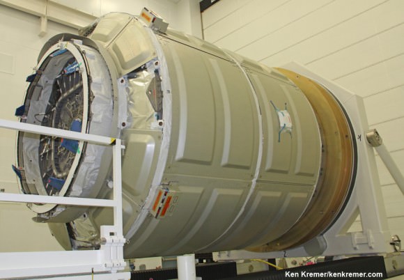
This Cygnus launched atop Antares on Jan. 9 and docked on Jan. 12   Cygnus pressurized cargo module – side view – during exclusive visit by  Ken Kremer/Universe Today to observe prelaunch processing by Orbital Sciences at NASA Wallops, VA. ISS astronauts will open this hatch to unload 2780 pounds of cargo.  Docking mechanism hooks and latches to ISS at left. Credit: Ken Kremer – kenkremer.com
This Cygnus launched atop Antares on Jan. 9 and docked on Jan. 12
Cygnus pressurized cargo module – side view – during exclusive visit by Ken Kremer/Universe Today to observe prelaunch processing by Orbital Sciences at NASA Wallops, VA. ISS astronauts will open this hatch to unload 2780 pounds of cargo. Docking mechanism hooks and latches to ISS at left. Credit: Ken Kremer – kenkremer.com

Cygnus departure is required to make way for the next private American cargo freighter – the SpaceX Dragon, which is now slated to blast off from Cape Canaveral, Florida on March 16 atop the company’s upgraded Falcon 9 booster.

Two additional Antares/Cygnus flights are slated for this year.

They are scheduled to lift off around May 1 and early October, said Culbertson.

Indeed there will be a flurry of visiting vehicles to the ISS throughout this year and beyond – creating a space traffic jam of sorts.

Stay tuned here for Ken’s continuing Orbital Sciences, SpaceX, commercial space, Orion, Chang’e-3, LADEE, Mars rover, MAVEN, MOM and more planetary and human spaceflight news.
Ken Kremer

ISS Astronauts grapple Orbital Sciences Cygnus spacecraft with robotic arm and guide it to docking port. Credit: NASA TV

Savage Spacesuit: ‘Mythbusters’ Host’s Mercury Costume Looks Real Enough For Space

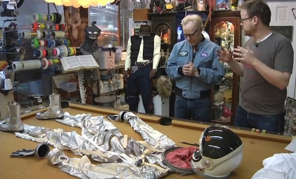
Mythbusters' Adam Savage shows off a Mercury replica spacesuit in February 2014. Credit: Tested/YouTube (screenshot)

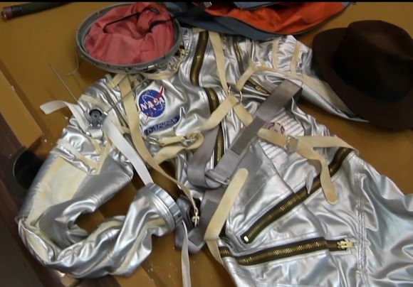
Who wants Adam Savage’s job right now? The cohost of Mythbusters spent the last year working with a San Francisco Bay-area costume designer to come up with this remarkable Mercury spacesuit. While it’s not a faithful replica of any one mission — it’s more a blend of greatest hits from the designs of several — it really looks like Savage could step into a spacecraft at any moment.

“The whole point of the Mercury program … was to figure out how to safely get people into space and what would happen to them,” Savage says in a new video, which you can see below.

“So every single time they came down from a Mercury mission they [the astronauts] would talk to the engineers and spend weeks in meetings going ‘Okay, I couldn’t move my arm this way. I couldn’t hit this switch in this way. I couldn’t turn my head.”

As if that isn’t cool enough, Savage also is sporting an Apollo flight jacket replica that is advertised as being pretty darn close to the original. Check out Adam Savage’s Tested blog for amazing photos as well as a more complete video (for premium members.)

Mercury was the first American spaceflight program, and had six flights between 1961 and 1963. For more information about the Mercury spacesuit, check out this chapter from NASA book “This New Ocean: A History of Project Mercury“. You can also see a photo gallery of different Mercury suits.

Coincidentally, there’s a travelling exhibit on about the history of spacesuits, which Universe Today’s David Dickinson wrote about last week.

Mythbusters' Adam Savage (left) in front of a replica Mercury spacesuit. Credit: Tested/YouTube (screenshot)
Mythbusters’ Adam Savage (left) in front of a replica Mercury spacesuit. Credit: Tested/YouTube (screenshot)
A close-up of a Mercury replica spacesuit ordered by Mythbusters' Adam Savage. Credit: Tested/YouTube (screenshot)
A close-up of a Mercury replica spacesuit ordered by Mythbusters’ Adam Savage. Credit: Tested/YouTube (screenshot)

Morpheus Robot Flies As High As The Great Pyramid Before Deking Sideways And Touching Down

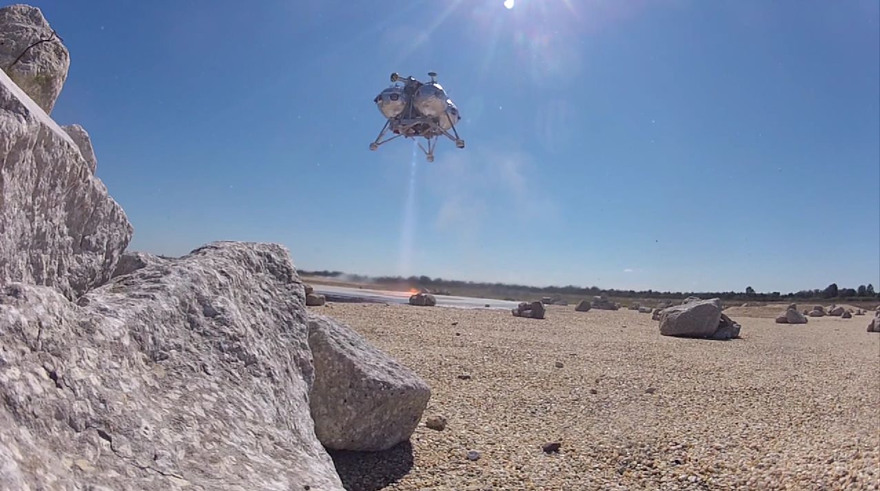
The Morpheus lander comes in for a safe landing during a flight on Feb. 10, 2014. Credit: Project Morpheus/YouTube (screenshot)

If it weren’t for that blue sky and those trees in behind, we’d be convinced that this little robot is landing on Mars. The Morpheus Lander once again proved how hard-core amazing these free flights are, as the automated robot soared 467 feet (142 meters) high Feb. 10 before jaunting sideways and making a bang-on-target landing.

“Today we went as high as the top of Great Pyramid of Giza,” the NASA Morpheus Lander Twitter feed said, adding that the team was enjoying “celebratory brownies” to mark the milestone. You can watch the whole video below (and we dare you not to gape during that sideways maneuver.)

The goal of Morpheus is to figure out landing technologies for other planets at a low cost, and lately the project has hit a series of literal highs as the robot made successful free flight after free flight. An earlier prototype crashed and burned in 2012, but the team implemented redesigns and has not lost a craft since.

On Feb. 14, Morpheus also completed a series of ground “hot fire” tests to gather data on how the engines are performing. On that day, the project’s Twitter feed assured followers that another free flight test would come “very soon.”

100 Days of MOM – India’s 1st Mars Mission Streaking to Red Planet Rendezvous

India’s Mars Orbiter Mission (MOM) completes 100 days in space on February 12, 2014 on its journey to reach the Red Planet on Sept 24, 2014. Credit ISRO

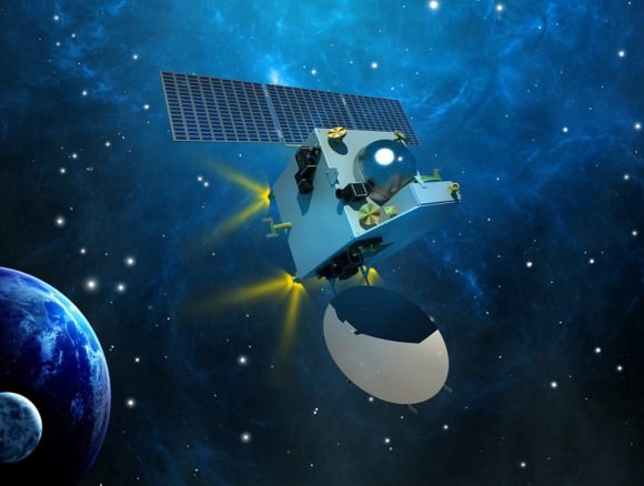
India’s maiden Mars explorer, the Mars Orbiter Mission or MOM, celebrated 100 days speeding through space this past week, racing outwards on its historic journey to the Red Planet.

After streaking through space for some ten and a half months, the 1,350 kilogram (2,980 pound) MOM probe will rendezvous with the Red Planet on September 24, 2014 – where she will study the atmosphere and sniff for signals of methane.

Feb. 12, 2014 marked ‘100 Days of MOM’ since the picture perfect blast off on Nov. 5, 2013 from India’s spaceport at the Satish Dhawan Space Centre, Sriharikota, atop the nations indigenous Polar Satellite Launch Vehicle (PSLV) which placed the probe into its initial Earth parking orbit.

First ever image of Earth Taken by Mars Color Camera aboard India’s Mars Orbiter Mission (MOM) spacecraft while orbiting Earth and before the Trans Mars Insertion firing on Dec. 1, 2013. Image is focused on the Indian subcontinent.  Credit: ISRO
First ever image of Earth Taken by Mars Color Camera aboard India’s Mars Orbiter Mission (MOM) spacecraft while orbiting Earth and before the Trans Mars Insertion firing on Dec. 1, 2013. Image is focused on the Indian subcontinent. Credit: ISRO

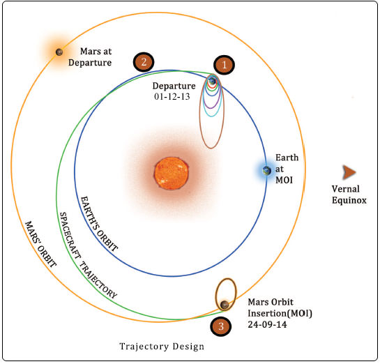
A series of six subsequent orbit raising maneuvers ultimately culminated with the liquid fueled main engine firing on Dec. 1, 2013 for the Trans Mars Injection(TMI) maneuver that successfully placed MOM on a heliocentric elliptical trajectory to the Red Planet.

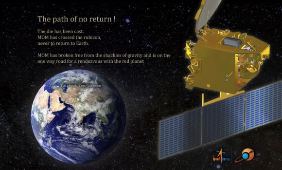
The TMI, affectionately dubbed ‘The mother of all slingshots’ finally provided the craft with sufficient thrust to achieve escape velocity and blast free of the Earth’s sphere of influence forever and begin her nearly yearlong momentous voyage to Mars.

The first of four in flight Trajectory Correction Maneuvers, TCM-1, was conducted by firing the 22 Newton Thrusters for a duration of 40.5 seconds on December 11, 2013. A trio of additional TCM firings are planned around April 2014, August 2014 and September 2014.

Trans Mars Injection (TMI), carried out on Dec 01, 2013 at 00:49 hrs (IST) has moved the spacecraft in the Mars Transfer Trajectory (MTT). With TMI the Earth orbiting phase of the spacecraft ended and the spacecraft is now on a course to encounter Mars after a journey of about 10 months around the Sun. Credit: ISRO

MOM was designed and developed by the Indian Space Research Organization’s (ISRO) at a cost of $69 Million and marks India’s inaugural foray into interplanetary flight.

During the first 100 days, the probe has traveled about 190 million kilometers and has a little less than 500 million kilometers and 205 days to go during her journey of some 680 million kilometers (400 million miles) overall.

A health check on February 6, 2014 confirmed that the 15 kg (33 lb) science payload comprising five Indian built instruments was turned “ON” and is operating well.

MOM is currently some 16 million km distant from Earth and one way radio signals take approximately 55 seconds.

“The round trip time is almost 2 minutes for a communication signal to go to MOM and come back, about the same time mom takes to make noodles!” ISRO noted humorously in a Facebook mission posting.

“Keep going MOM!”

MOM's first Trajectory Correction Manoeuver in Baiju Raj's imagination.
MOM’s first Trajectory Correction Manoeuver in Baiju Raj’s imagination.

Following the ten month cruise through space the orbital insertion engine will fire for the do or die burn on September 24, 2014 placing MOM into an 377 km x 80,000 km elliptical orbit around Mars.

MOM is not alone in the frigid vacuum of space. She is joined by NASA’s MAVEN orbiter in pursuit of Mars.

MOM will reach Mars vicinity just two days after the arrival MAVEN on Sept. 22, 2014.

To date MAVEN has flown over 137 million miles (221 million km) of its total 442 million miles (712 million km) path to Mars.

If all continues to goes well, India will join an elite club of only four who have launched probes that successfully investigated the Red Planet from orbit or the surface – following the Soviet Union, the United States and the European Space Agency (ESA).

Both MAVEN and MOM’s goal is to study the Martian atmosphere, unlock the mysteries of its current atmosphere and determine how, why and when the atmosphere and liquid water was lost – and how this transformed Mars climate into its cold, desiccated state of today.

Together, MOM and MAVEN will fortify Earth’s invasion fleet at Mars. They join 3 current orbiters from NASA and ESA as well as NASA’s pair of sister surface roversCuriosity and Opportunity.

Although they were developed independently and have different suites of scientific instruments, the MAVEN and MOM science teams will “work together” to unlock the secrets of Mars atmosphere and climate history, MAVEN’s top scientist told Universe Today.

“We have had some discussions with their science team, and there are some overlapping objectives,” Bruce Jakosky told me. Jakosky is MAVEN’s principal Investigator from the University of Colorado at Boulder.

“At the point where we [MAVEN and MOM] are both in orbit collecting data we do plan to collaborate and work together with the data jointly,” Jakosky said.

Stay tuned here for Ken’s continuing MOM, Opportunity, Curiosity, Chang’e-3, LADEE, MAVEN, Mars rover and more planetary and human spaceflight news.

Ken Kremer

1452418_1402640509973889_477104420_n