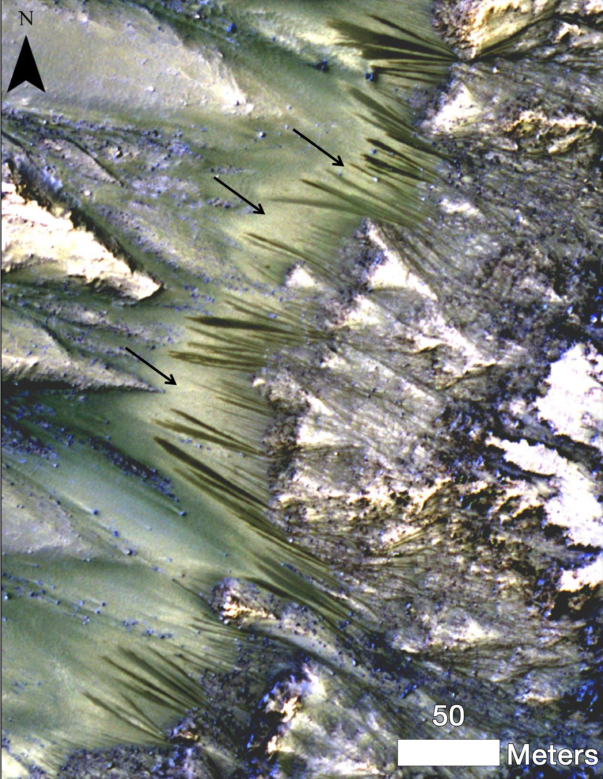
Palikir Crater as seen by the Mars Reconnaissance Orbiter's High Resolution Imaging Science Experiment (HiRISE) camera. Visible are warm-season flows called "recurring slope linea" that could have been created by salty liquid water. Credit: NASA/JPL-Caltech/UA/JHU-APL
One hotspot of debate are flows called “recurring slope lineae”, which are features that appear in warmer temperatures. These would seem to imply some kind of briny water flowing. A team recently checked out 13 of these sites. While they didn’t find any water or salt evidence in the spectra, they did find more iron-bearing minerals on “RSL slopes” compared to those that aren’t. So what’s going on?
“We still don’t have a smoking gun for existence of water in RSL, although we’re not sure how this process would take place without water,” stated Lujendra Ojha, a graduate student at the Georgia Institute of Technology in Atlanta who led two reports on these features. Pictures were taken using NASA’s Mars Reconnaissance Orbiter’s High Resolution Imaging Science Experiment (HiRISE), which is led by the University of Arizona.
Palikir Crater as seen by the Mars Reconnaissance Orbiter’s High Resolution Imaging Science Experiment (HiRISE) camera. Visible are warm-season flows called “recurring slope linea” that could have been created by salty liquid water. Credit: NASA/JPL-Caltech/UA/JHU-APL
It’s possible that the grains are being sorted by size (more plainly speaking, taking the fine dust away and leaving the larger grains behind), which could happen either with water or without it. Or, water might be present but not in a way that is obvious immediately if the area got darker because of moisture, or the minerals became oxidized. Water could be “missing” from these observations because they took place in the afternoon (meaning they could miss morning dew), or because the dark flows are smaller than the sample size in the picture.
While researchers still aren’t sure, the team says they still believe it’s salty water of some sort that is flowing despite very cold temperatures on Mars.
“The flow of water, even briny water, anywhere on Mars today would be a major discovery, impacting our understanding of present climate change on Mars and possibly indicating potential habitats for life near the surface on modern Mars,” said Richard Zurek, MRO project scientist who is at NASA’s Jet Propulsion Laboratory in California.
A related paper also found that RSL sites are rare on Mars, appearing in only 13 of 200 sites surveyed with similar slopes, latitudes and other features. You can read the accepted versions of the reports as they appear in Geophysical Research Letters and Icarus.
Credit: Inside Science News Service and Amanda Page
As the Beatles strummed the opening notes to “All My Loving” on the Ed Sullivan Show 50 years ago yesterday, few could have imagined how wide-ranging that music would be. The broadcast gave birth to a global music phenomenon. And like all TV broadcasts of the day, the music carried out into space at the speed of light.
The Inside Science infographic above (see below for the full version) traces the history of the Beatles in relation to how far the broadcast travelled in that time. While those waves were washing out, er, across the universe, the Beatles have been taking over human space exploration in other ways. Below the jump are seven of the more memorable moments.
Rocking The Space Station With ‘Back at the ISS’
Technically speaking, this isn’t the Beatles, but it sure was inspired by them. ‘Back at the ISS’ — the remake of ‘Back in the U.S.S.R.’ by Dutch band Love & Mersey — is about a billion shades of awesome. Not only because of the lyrics, not only because of the high-energy space-themed video, but also because they sang in three languages. The song was released in March 2012 as a “rocking musical greeting” to Andre Kuipers (a European Space Agency astronaut) and the rest of the Expedition 30 crew days before the docking of the Automated Transfer Vehicle Edoardo Amaldi that month.
The Beatles have been used to wake up several shuttle crews, and also the Curiosity rover. Explained Eric Blood, Curiosity’s surface systems engineer: “She tends to be less cranky with a good wakeup song.”
Playing (And Drinking?) English Tea In Space
Here’s Paul McCartney in 2005 casually playing two tunes to the Expedition 12 crew — NASA astronaut Bill McArthur and Russian cosmonaut Valery Tokarev — during a live concert. It’s a bit hard to tell who had bigger stars in their eyes after the experience. “I told the audience ‘I think I need about 20 minutes to go have a lie down,’ McCartney stated in a NASA release from the time. “What do you do after that? We haven’t stopped talking about it since.”
Roll Over Beethoven: How The Beatles Almost Made Voyager’s ‘Golden Record’
Remember when scientists announced last year that Voyager 1 entered interstellar space? On board the spacecraft was a Golden Record intended to give aliens a glimpse into what Earth’s life is like. Included were songs from artists ranging from Bach to Blind Willie Johnson, but not the Beatles. They were almost included, though, as astronomer Carl Sagan (who chaired the selection committee) explained in his 1978 book Murmers of Earth. “We wanted to send ‘Here Comes The Sun’ by the Beatles, and all four Beatles gave their approval. But the Beatles did not own the copyright, and the legal status of the piece seemed too murky to risk,” he wrote.
Joining Mr. Mercury’s Light
There are so many earthly memorials to John Lennon after the singer’s untimely death in 1980, but late last year he got an extraterrestrial honor. Lennon was among 10 names approved for craters on the planet Mercury. “It’s unlikely that Mercury’s surface is populated with tangerine trees and marmalade skies, but the famous British musician who coined that phrase now has a physical presence on the planet closest to the Sun,” NASA said.
Sending Love To The Aliens With Jai Guru Deva Om
February 4, 2008 marked the first time NASA beamed any song into deep space, and what better choice than “Across The Universe”? The date marked the 40th anniversary of when the Beatles recorded the song, and came around the same time as the 45th anniversary of NASA’s Deep Space Network and the 50th anniversary of NASA’s first satellite, Explorer 1, among other milestones. In a statement, McCartney asked to “send my love to the aliens.”
What Beatles milestones in space have we missed? Let us know in the comments.
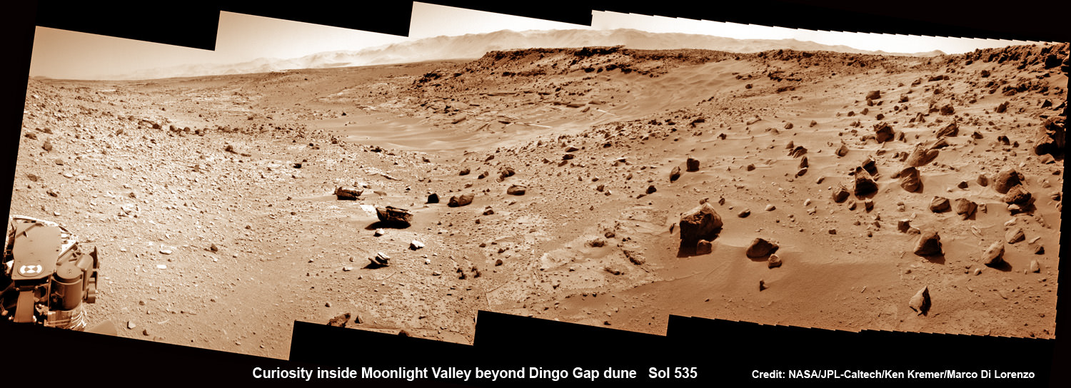
Curiosity scans Moonlight Valley beyond Dingo Gap Dune. Curiosity’s view to “Moonlight Valley” beyond after crossing over ‘Dingo Gap’ sand dune. This photomosaic was taken after Curiosity drove over the 1 meter tall Dingo Gap sand dune and shows dramatic scenery in the valley beyond, back dropped by eroded rim of Gale Crater. Assembled from navigation camera (navcam) raw images from Sol 535 (Feb. 6, 2104) Credit: NASA/JPL-Caltech/Ken Kremer- kenkremer.com/Marco Di Lorenzo
Curiosity scans Moonlight Valley beyond Dingo Gap Dune.
Curiosity’s view to “Moonlight Valley” beyond after crossing over ‘Dingo Gap’ sand dune. This photomosaic was taken after Curiosity drove over the 1 meter tall Dingo Gap sand dune and shows dramatic scenery in the valley beyond, back dropped by eroded rim of Gale Crater. Assembled from navigation camera (navcam) raw images from Sol 535 (Feb. 6, 2104) Credit: NASA/JPL-Caltech/Ken Kremer- kenkremer.com/Marco Di Lorenzo
See below more before/after Dingo Gap imagery
Story updated[/caption]
NASA’s Curiosity mega rover has successfully crossed over the ‘Dingo Gap’ sand dune- opening the gateway to the science rich targets in the “Moonlight Valley” and Martian mountain beyond.
“I’m over the moon that I’m over the dune! I successfully crossed the “Dingo Gap” sand dune on Mars,” Curiosity tweeted overnight Thursday.
“Moonlight Valley” is the name of the breathtaking new locale beyond Dingo, Curiosity Principal Investigator John Grotzinger, of Caltech, told Universe Today.
Curiosity drove westward over the 1 meter ( 3 foot) tall Dingo Gap dune in stellar style on Thursday, Feb. 6, on Sol 535.
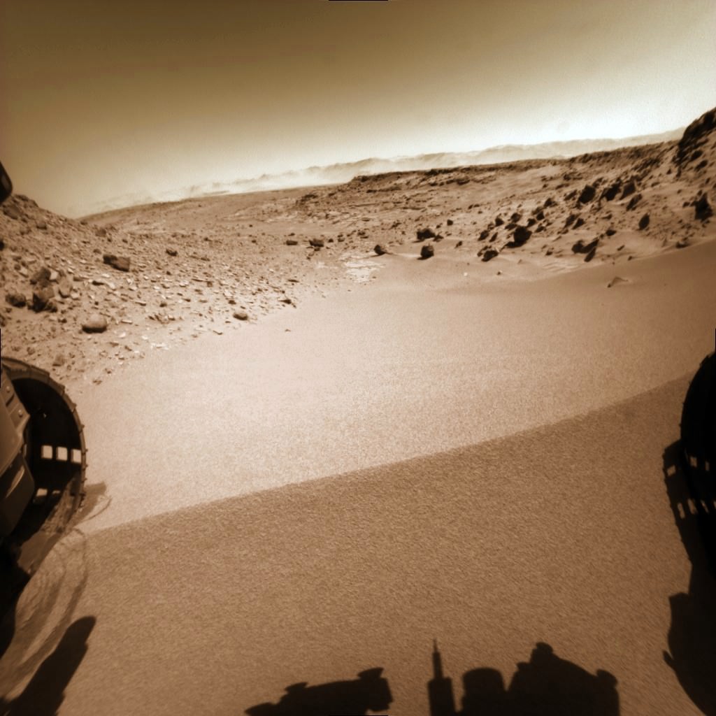
Curiosity looks back to ‘Dingo Gap’ sand dune after crossing over, backdropped by Mount Sharp on Sol 535, Feb. 5, 2014. Hazcam fisheye image linearized and colorized. Credit: NASA/JPL/Marco Di Lorenzo/Ken Kremer- kenkremer.com
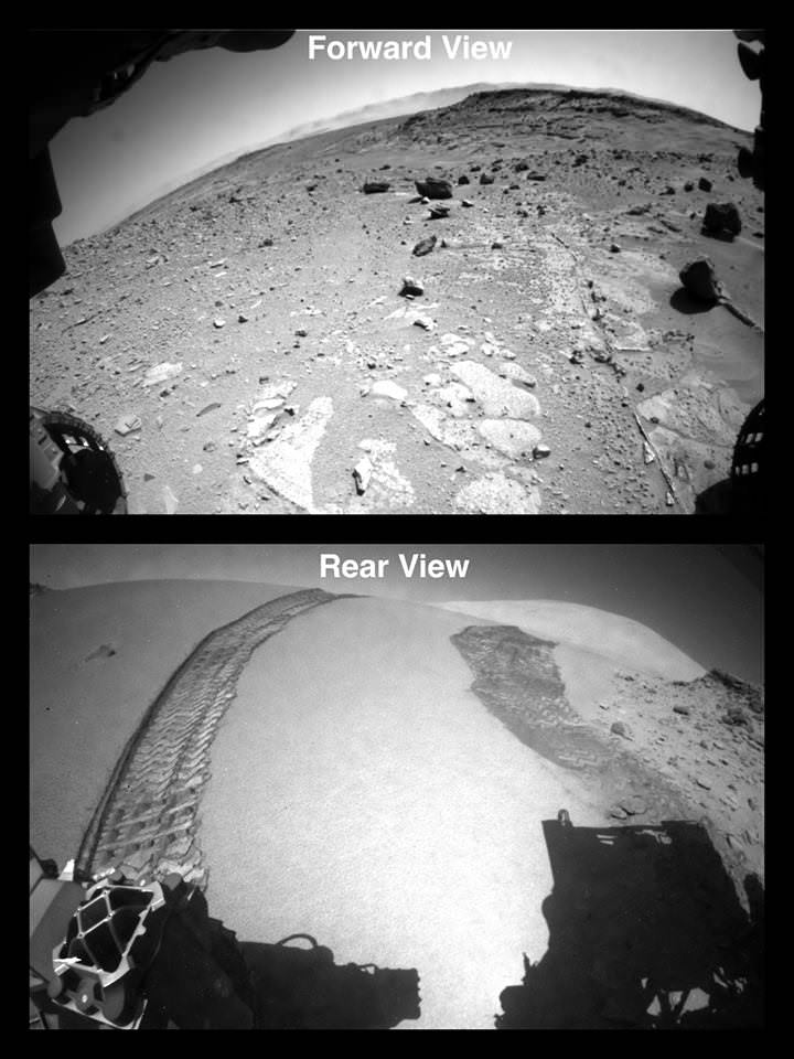
Dramatic before and after photos reveal that the rover passed over the Red Planet dune without difficulty. They also show some interesting veins and mineral fractures are visible in the vicinity just ahead.
“Moonlight Valley has got lots of veins cutting through it,” Grotzinger told me.
“We’re seeing recessive bedrock.”
The Martian dune lies between two low scarps sitting at the north and south ends.
“The rover successfully traversed the dune in Dingo Gap,” wrote science team member Ken Herkenhoff in an update.
“The data look good.”
Curiosity Crosses ‘Dingo Gap’ sand dune – Looking forward and back on Sol 535. Hazcam camera images. Credit: NASA
Since arriving at the picturesque “Dingo Gap” sand dune about a week ago, Curiosity’s handlers had pondered whether to breach the dune as an alternate pathway into the smoother terrain of the valley beyond as a work around to avoid fields of rough rocks that have been ripping holes into the robots six aluminum wheels in recent months.
“We’re guessing it will be softer on the wheels,” Grotzinger informed me.
Before giving the go ahead to move forward, engineers took a few days to carefully assess the dune’s integrity and physical characteristics with the rovers science instruments and cameras to insure there wasn’t the potential to get irretrievably stuck in a deep sand trap.
The team even commanded Curiosity to carry out a toe dip by gently rolling the 20 inch (50 cm) diameter wheels back and forth over the crest on Tuesday, Feb. 4 to insure it was safe to mount.
They won’t take any chances with safety, recalling that rover Spirit’s demise occurred when she because mired in a hidden sand trap in 2010 from which there was ultimately no escape. She froze to death during the bitter Martin winter – more than 6 years into her 90 day mission.
Opportunity also got wedged at the seemingly endless dune field at “Purgatory Dune”, that nearly doomed her early in the now decade long trek. Engineers spent weeks on the extrication effort.
Curiosity does a “toe dip” wheel motion test at Dingo Gap sand dune on Sol 534, Feb 5, 2014 before crossing dune on Sol 535. Hazcam image linearized and colorized. Credit: NASA/JPL/Marco Di Lorenzo/Ken Kremer- kenkremer.com
Since last summer, Curiosity has been traveling on a southwestward route to the breathtaking foothills of Mount Sharp, her ultimate science destination.
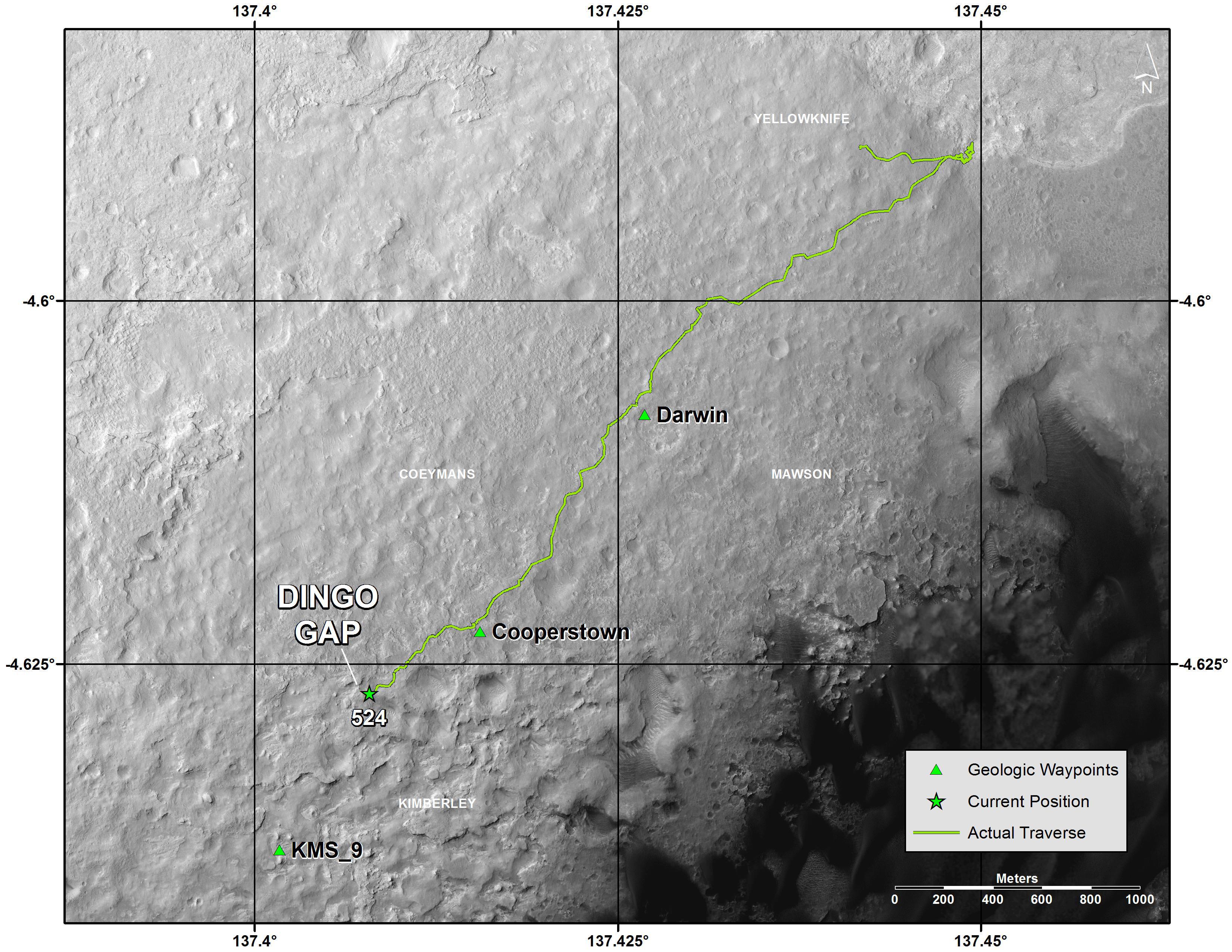
The westward route though Dingo will soon lead Curiosity to a spot dubbed “KMS-9” where the team hopes to conduct the first rock drilling operations since departing the Yellowknife Bay quadrant in July 2013, into areas of intriguing bedrock.
“At KMS-9, we see three terrain types exposed and a relatively dust-free surface,” said science team collaborator Katie Stack of the California Institute of Technology, Pasadena.
The missions science focus has shifted to “search for that subset of habitable environments which also preserves organic carbon,” says Curiosity Principal Investigator John Grotzinger, of the California Institute of Technology in Pasadena.
But first, with the dune now safely in the rear view mirror, the team plans a busy weekend of research activities.
A big science program using the X-Ray spectrometer and high resolution MAHLI camera on the robotic arm is already planned for this weekend.
“The arm will be deployed to investigate some interesting veins or minerals filling fractures in front of the rover,” says Herkenhoff.
“ChemCam will search for frost early on the morning of Sol 538 (Saturday), then analyze targets Collett and Mussell along the vein/fracture fill later in the day.”
Thereafter Curiosity will continue on its journey across the floor of Gale Crater, taking images and atmospheric measurements along the way to the sedimentary layers at the base of Mount Sharp.
Curiosity has already accomplished her primary goal of discovering a habitable zone on Mars that could support Martian microbes if they ever existed.
And be sure to check out Curiosity’s first ever image of Earth from Mars in my new story – here.
To date Curiosity’s odometer stands at nearly 5 kilometers and she has taken over 118,000 images.
The robot has about another 5 km to go to reach Mount Sharp.
Stay tuned here for Ken’s continuing Curiosity, Opportunity, Chang’e-3, SpaceX, Orbital Sciences, LADEE, MAVEN, MOM, Mars and more planetary and human spaceflight news.
You are here! As an Evening Star in the Martian Sky
This evening-sky view taken by NASA’s Mars rover Curiosity shows the Earth and Earth’s moon as seen on Jan. 31, 2014, or Sol 529 shortly after sunset at the Dingo Gap inside Gale Crater. Credit: NASA/JPL-Caltech/MSSS/TAMUCuriosity’s View Past Tall Dune at edge of ‘Dingo Gap’
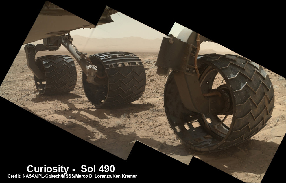
This photomosaic from Curiosity’s Navigation Camera (Navcam) taken at the edge of the entrance to the Dingo Gap shows a 3 foot (1 meter) tall dune and valley terrain beyond to the west, all dramatically back dropped by eroded rim of Gale Crater. View from the rover’s overlook position on Sol 528 (Jan. 30, 2014). The rover team has now commanded Curiosity to bridge the dune gap as a smoother path to next science destination. Credit: NASA/JPL-Caltech/Marco Di Lorenzo/Ken Kremer- kenkremer.comUp close view of hole in one of rover Curiosity’s six wheels caused by recent driving over rough Martian rocks. Mosaic assembled from Mastcam raw images taken on Dec. 22, 2013 (Sol 490). Credit: NASA/JPL/MSSS/Ken Kremer – kenkremer.com/Marco Di Lorenzo
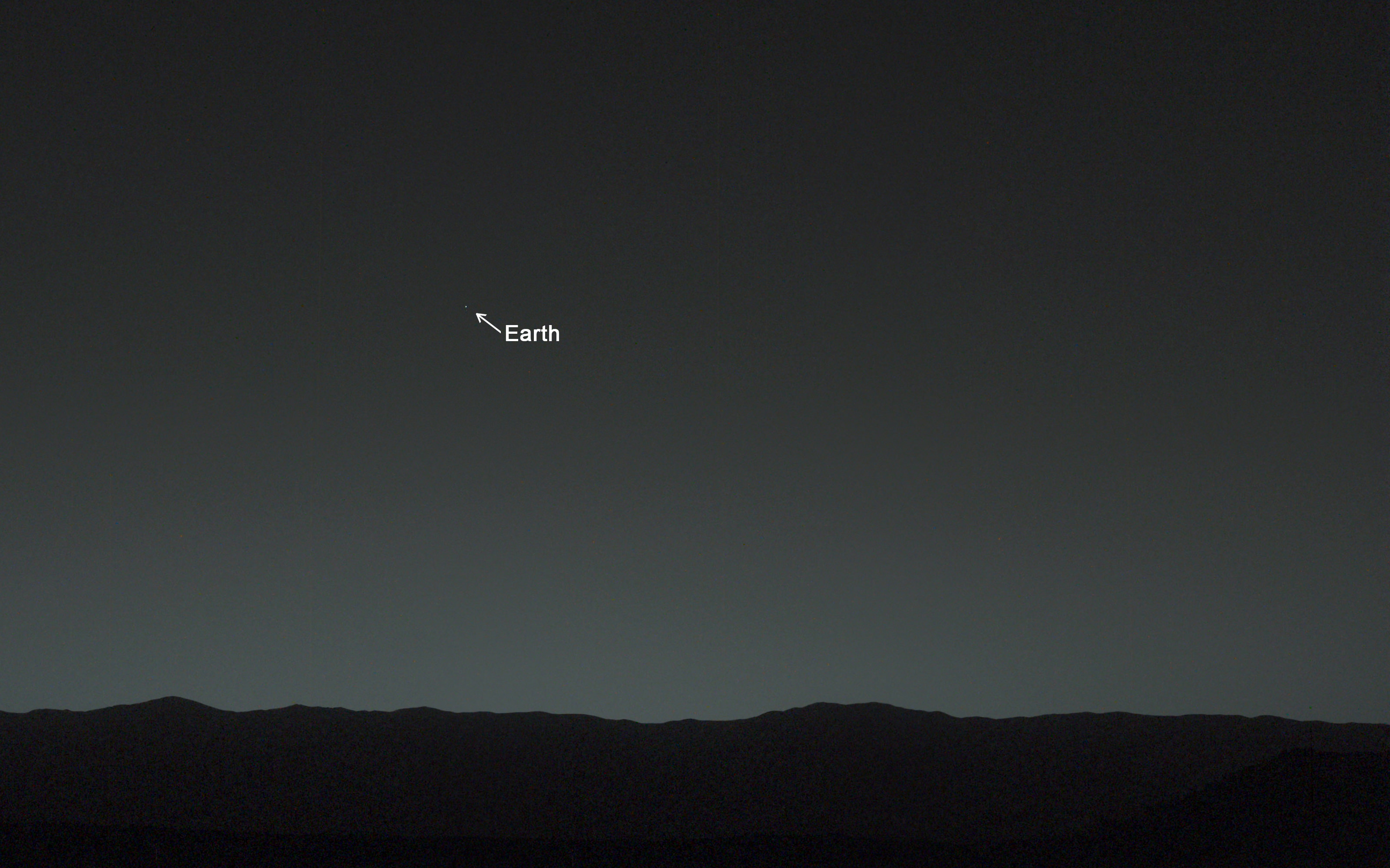
You are here! As an Evening Star in the Martian Sky. This evening-sky view taken by NASA's Mars rover Curiosity shows the Earth and Earth's moon as seen on Jan. 31, 2014, or Sol 529 shortly after sunset at the Dingo Gap inside Gale Crater. Credit: NASA/JPL-Caltech/MSSS/TAMU
You are here! – As an Evening Star in the Martian Sky
This evening-sky view taken by NASA’s Mars rover Curiosity shows the Earth and Earth’s moon as seen on Jan. 31, 2014, or Sol 529 shortly after sunset at the Dingo Gap inside Gale Crater.
Credit: NASA/JPL-Caltech/MSSS/TAMU
See more imagery of the Earth and Moon below!
Story updated[/caption]
18 months into her mission to discover a habitable zone on the Red Planet, NASA’s Curiosity rover has at last looked back to the inhabited zone of all humanity and snapped her 1st image of all 7 Billion Earthlings living on the Home Planet.
“Look Back in Wonder… My first picture of Earth from the surface of Mars,” tweeted Curiosity today.
You are there! See yourselves in the spectacular imagery from the Red Planet’s surface at the ‘Dingo Gap’ inside Gale Crater – above and below.
Car sized Curiosity captured the evocative image of Earth as an evening star in the Martian sky just days ago on Jan. 31, 2014, or Sol 529, some 80 minutes after sunset.
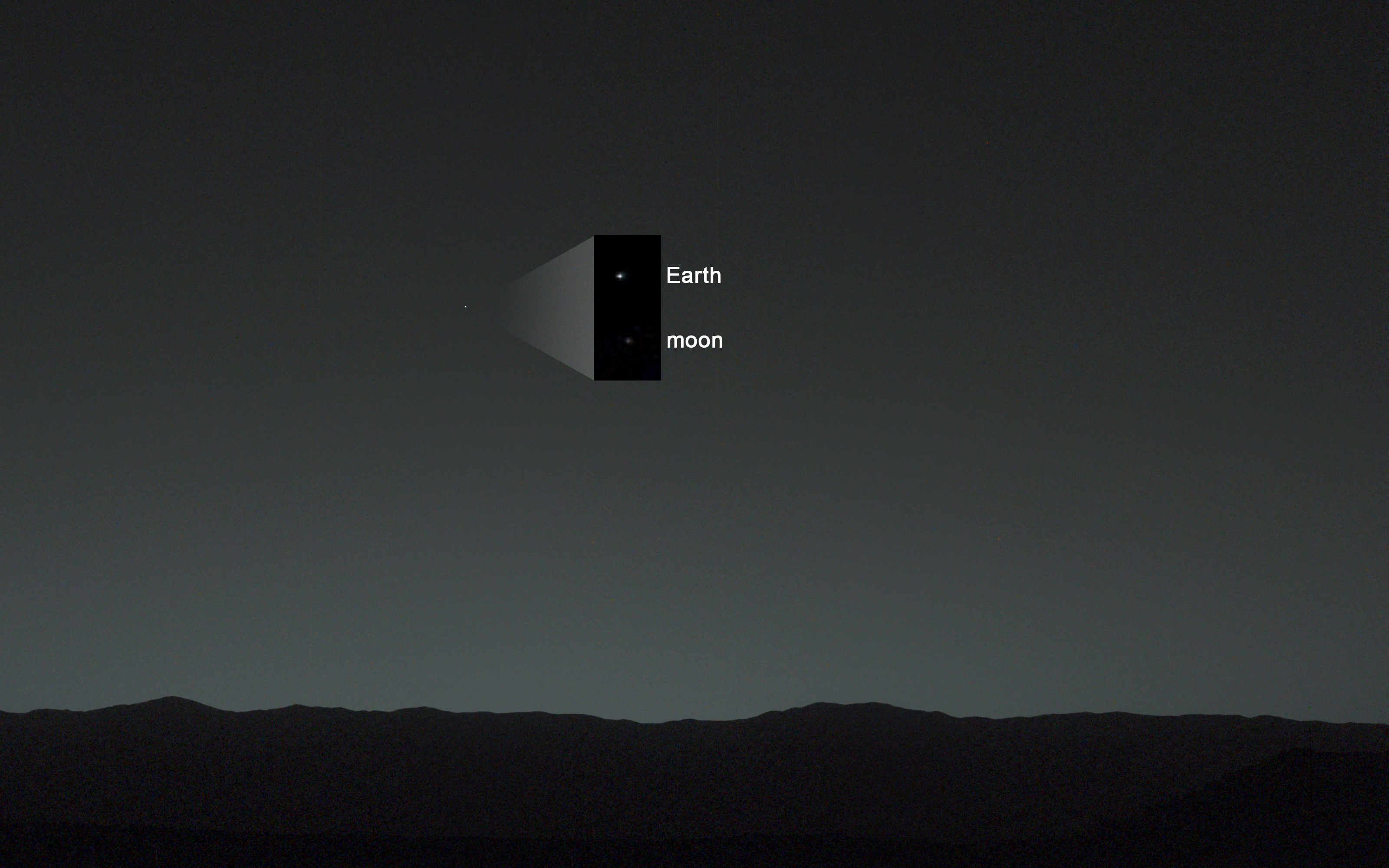
And what’s more is that the evening sky view even includes the Earth’s Moon!
Annotated evening-sky view taken by NASA’s Mars rover Curiosity shows the Earth and Earth’s moon – enlarged in inset – as seen on Jan. 31, 2014, or Sol 529 shortly after sunset at the Dingo Gap sand dune. Credit: NASA/JPL-Caltech/MSSS/TAMU
Earth shines brilliantly as the brightest beacon in the Martian twilight sky view taken from the 1 ton rovers current location at the edge of a sand dune dubbed the ‘Dingo Gap.’
“A human observer with normal vision, if standing on Mars, could easily see Earth and the moon as two distinct, bright “evening stars,” said NASA in a statement issued today.
1st Curiosity Snapshot of Earth taken from here –
Curiosity’s View Past Tall Dune at edge of ‘Dingo Gap’ sand dune
This photomosaic from Curiosity’s Navigation Camera (Navcam) taken at the edge of the entrance to the Dingo Gap shows a 3 foot (1 meter) tall dune and valley terrain beyond to the west, all dramatically back dropped by eroded rim of Gale Crater. View from the rover’s current position on Sol 528 (Jan. 30, 2014). The rover team may decide soon whether Curiosity will bridge the dune gap as a smoother path to next science destination.
Credit: NASA/JPL-Caltech/Marco Di Lorenzo/Ken Kremer- kenkremer.com
Curiosity used both of her high resolution mast mounted color cameras to collect a series of Earth/Moon images flittering across the Martian sky.
The Earth and the Moon in this evening-sky view taken by Curiosity’s telephoto Mastcam right -eye camera on Jan. 31, 2014, or Sol 529 shortly after sunset at the Dingo Gap. Moon’s brightness was enhanced to aid visibility. Credit: NASA/JPL-Caltech/MSSS/TAMU
Processing has removed the numerous cosmic ray strikes – see raw image below.
Right now Curiosity’s handlers are pondering whether to climb over the 1 meter tall sand dune and cross into the smooth terrain of the valley beyond the ‘Dingo Gap’ – as an alternate path to minimize damaging encounters with sharp edged Martian rocks that are puncturing holes and ripping tears into the robots six wheels.
To be clear, these are not the first images of the Earth from Mars orbit or Mars surface.
Two of NASA’s other Red Planet explorers also imaged Earth; Mars Global Surveyor in 2003 and Mars Reconnaissance Orbiter in 2007.
More recently, NASA’s Cassini orbiter at Saturn spied the Earth and Moon during the Wave at Saturn event in July 2013 from a distance of 898 million miles (1.44 billion kilometers).
And still more images of the Earth from NASA’s Mariner 10 and Juno Jupiter orbiter in my recent planetary exploration story – here
The most famous and distant of all is the ‘Pale Blue Dot’ image of Earth taken by NASA’s Voyager 1 probe in 1990 from about 6 billion kilometers (3.7 billion miles) away.
Stay tuned here for Ken’s continuing Curiosity, Opportunity, Chang’e-3, SpaceX, Orbital Sciences, LADEE, MAVEN, MOM, Mars and more planetary and human spaceflight news.
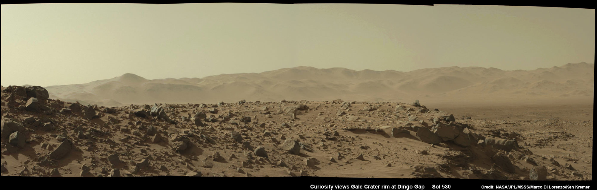
Curiosity Mastcam raw image showing the Earth in the Martian twilight sky on Jan. 31, 2014 amidst numerous cosmic ray strikes. . Credit: NASA/JPL-Caltech/MSSSCuriosity photographed You and all of humanity looking from somewhere above the eroded rim of Gale Crater – a portion of which is seen in this photomosaic taken by the same Mastcam camera on Feb 1, 2014, Sol 530, at the Dingo Gap sand dune. Credit: NASA/JPL-Caltech/MSSS/Marco Di Lorenzo/Ken Kremer- kenkremer.comPhotomosaic shows new holes and tears in several of rover Curiosity’s six wheels caused by recent driving over sharp edged Martian rocks on the months long trek to Mount Sharp. Raw images taken by the MAHLI camera on Curiosity’s arm on Jan. 31, 2014 (Sol 529) were assembled to show some recent damage to several of its six wheels. Credit: NASA / JPL / MSSS / Marco Di Lorenzo / Ken Kremer- kenkremer.com
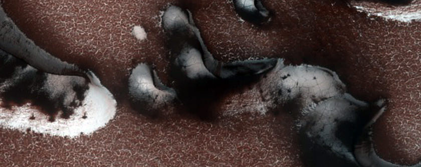
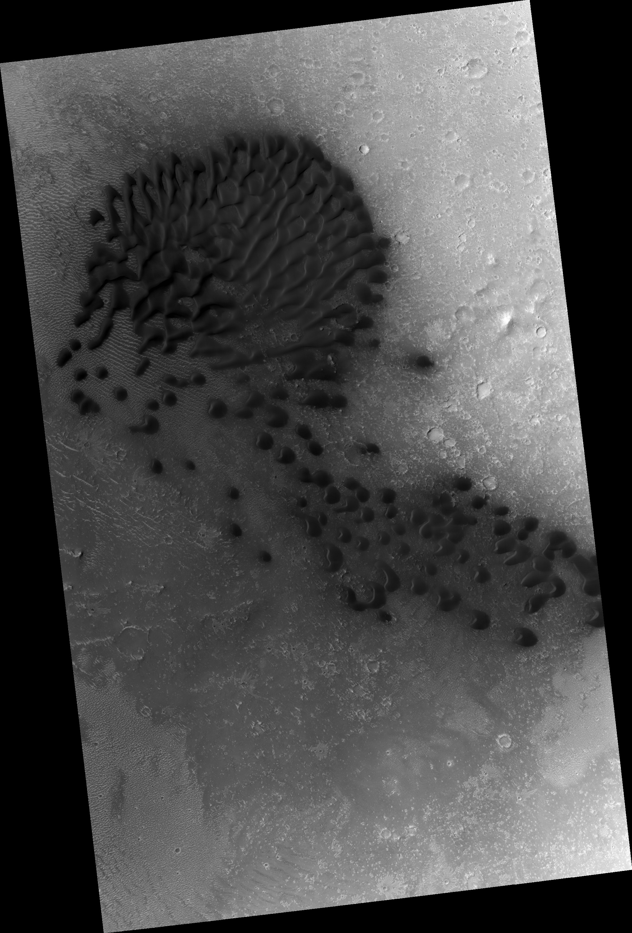
"Defrosting of dunes with large gullies", one of the images released in February 2014 from the Mars Reconnaissance Orbiter's High Resolution Imaging Science Experiment. Credit: NASA/JPL/University of Arizona
As NASA’s missions at the Red Planet age, it’s so important not to take any of the pictures beamed back to Earth for granted.
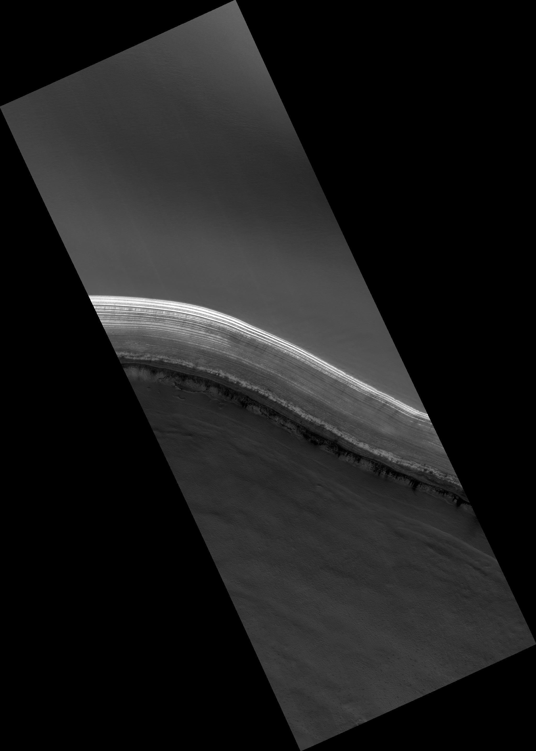
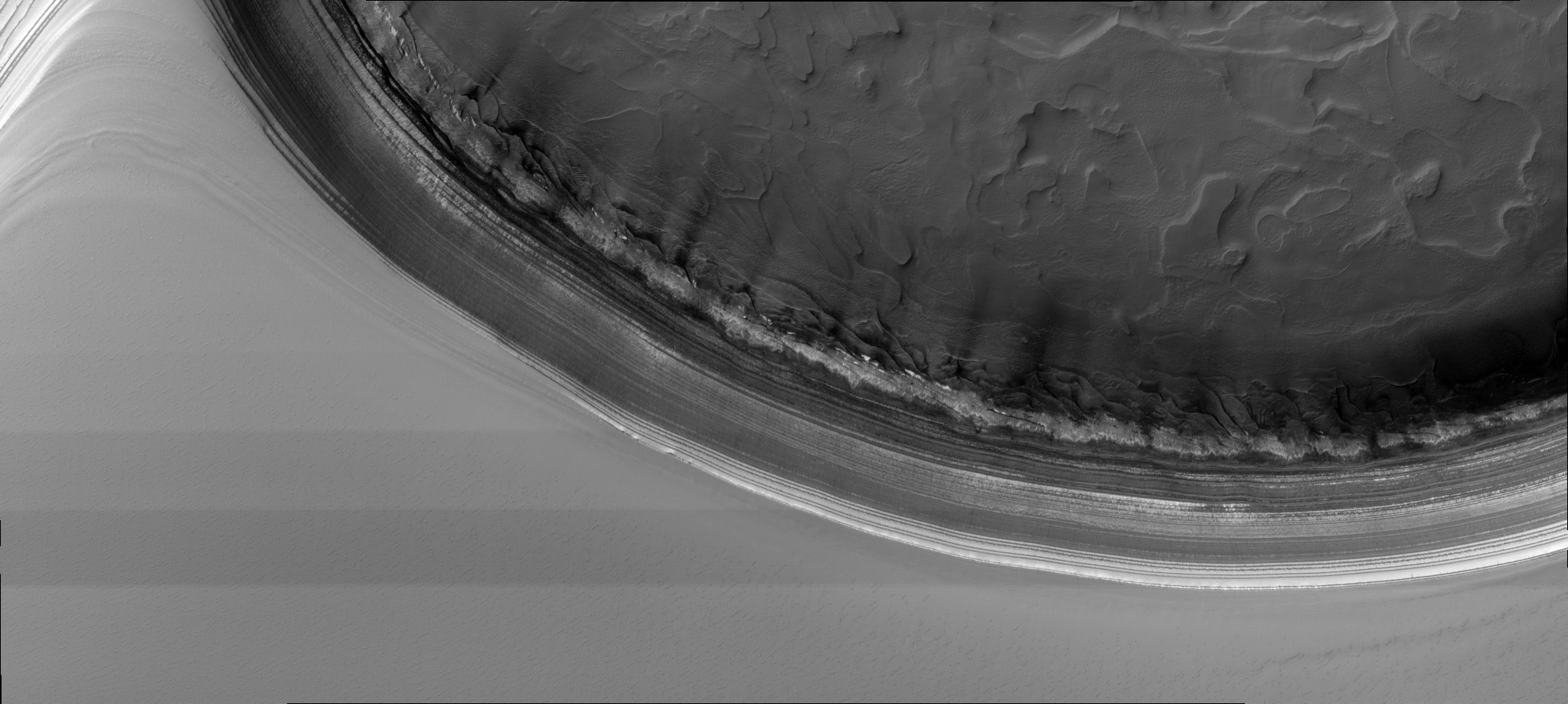
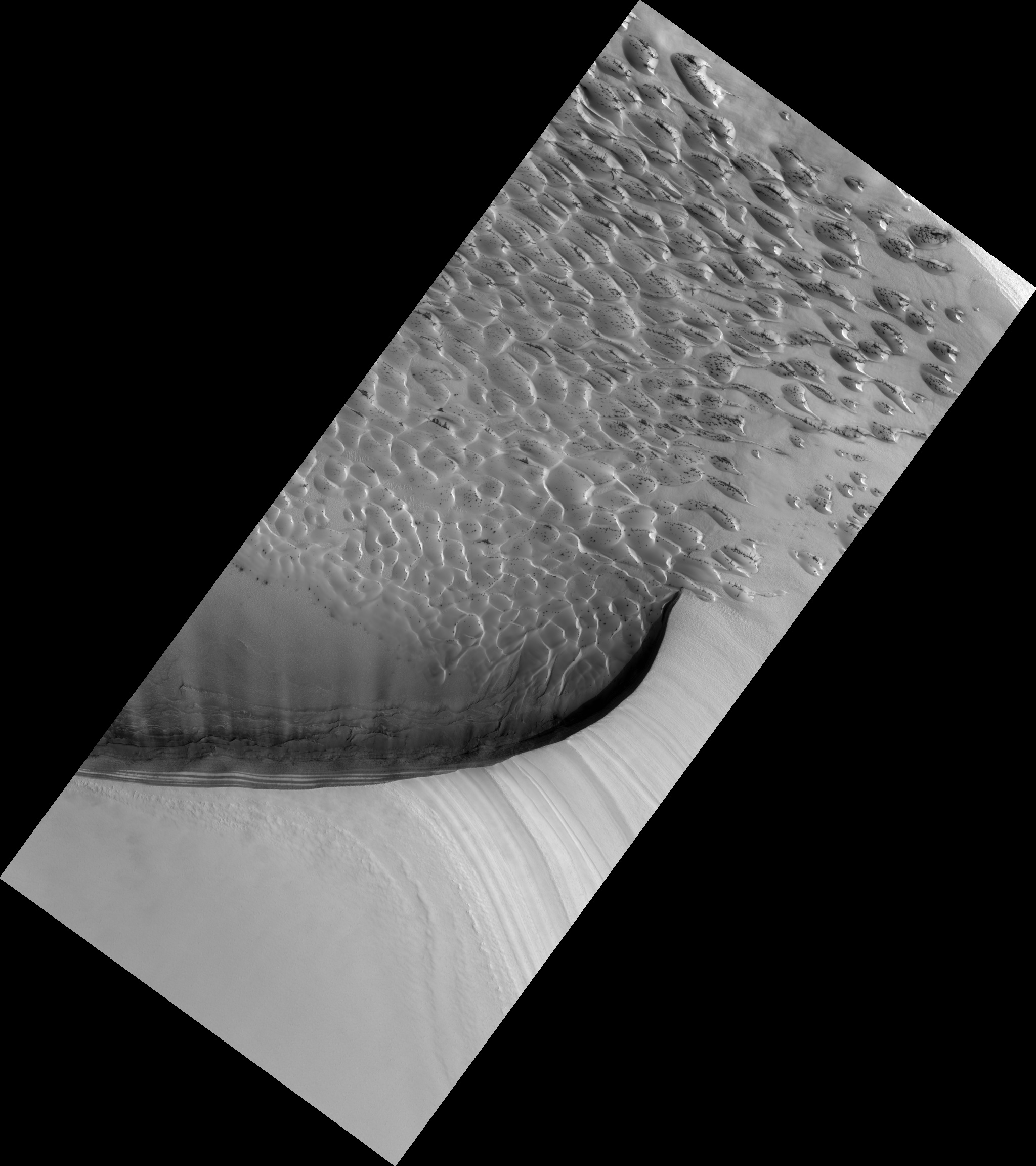
The latest release of raw images from the University of Arizona’s High Resolution Imaging Science Experiment (aboard the Mars Reconnaissance Orbiter, launched in 2005) is as close as most of us will get to seeing the Red Planet, and each picture captures a planet in action.
Snow, dust and wind are combining to make the incredible images you will see below. These shots, by the way, are close-ups colorized at the source; to see the full raw image, click on each picture you see below.
“Avalanche monitoring at steep chasma boreale headscarp”, one of the images released in February 2014 from the Mars Reconnaissance Orbiter’s High Resolution Imaging Science Experiment. Credit: NASA/JPL/University of Arizona“Avalanche monitoring at steep north polar scarp”, one of the images released in February 2014 from the Mars Reconnaissance Orbiter’s High Resolution Imaging Science Experiment. Credit: NASA/JPL/University of Arizona“Dunes with serious slope streaks dubbed tleilax”, one of the images released in February 2014 from the Mars Reconnaissance Orbiter’s High Resolution Imaging Science Experiment. (“Tleilax” is a reference to Dune, a science-fiction book series most famous for the eponymous first one concerning a desert planet.) Credit: NASA/JPL/University of Arizona“Cerberus region intracrater dune and ripple changes”, one of the images released in February 2014 from the Mars Reconnaissance Orbiter’s High Resolution Imaging Science Experiment. Credit: NASA/JPL/University of Arizona
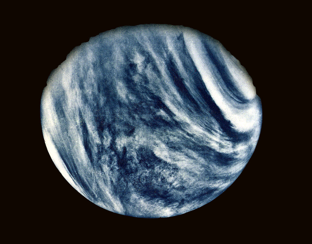
On Feb. 5, 1974, NASA's Mariner 10 mission took this first close-up photo of Venus during 1st gravity assist flyby. Credit: NASA
Exactly 40 Years ago today on Feb. 5, 1974, Mariner 10, accomplished a history making and groundbreaking feat when the NASA science probe became the first spacecraft ever to test out and execute the technique known as a planetary gravity assisted flyby used to alter its speed and trajectory – in order to reach another celestial body.
Mariner 10 flew by Venus 40 years ago to enable the probe to gain enough speed and alter its flight path to eventually become humanity’s first spacecraft to reach the planet Mercury, closest to our Sun.
Indeed it was the first spacecraft to visit two planets.
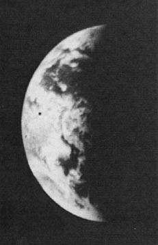
During the flyby precisely four decades ago, Mariner 10 snapped its 1st close up view of Venus – see above.
From that moment forward, gravity assisted slingshot maneuvers became an extremely important technique used numerous times by NASA to carry out planetary exploration missions that would not otherwise have been possible.
For example, NASA’s twin Voyager 1 and 2 probes launched barely three years later in 1977 used the gravity speed boost to conduct their own historic flyby expeditions to our Solar Systems outer planets.
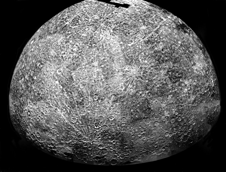
Mariner 10’s Mercury.
This is a photomosaic of images collected by Mariner 10 as it flew past Mercury on 29 March 1974. It shows the southern hemisphere. The spacecraft took more than 7,000 images of Mercury, Venus, the Earth, and the moon during its mission. Credit: NASA
Without the flyby’s, the rocket launchers thrust by themselves did not provide sufficient interplanetary speed to reach their follow on targets.
NASA’s Juno Jupiter orbiter just flew back around Earth this past October 9, 2013 to gain the speed it requires to reach the Jovian system.
The Mariner 10 probe used an ultraviolet filter in its imaging system to bring out details in the Venusian clouds which are otherwise featureless to the human eye – as you’ll notice when viewing it through a telescope.
Venus surface is completely obscured by a thick layer of carbon dioxide clouds.
The hellish planet’s surface temperature is 460 degrees Celsius or 900 degrees Fahrenheit.
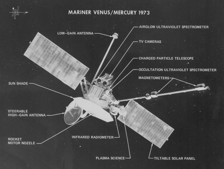
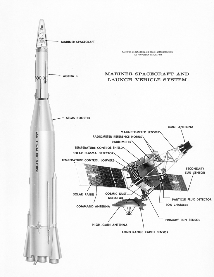
Diagram of Mariner 10 which flew by Venus and Mercury in 1974 and 1975. This photo identifies various parts of the spacecraft and the science instruments, which were used to study the atmospheric, surface, and physical characteristics of Venus and Mercury. This was the sixth in the series of Mariner spacecraft that explored the inner planets beginning in 1962. Credit: Jet Propulsion Laboratory
Following the completely successful Venus flyby, Mariner 10 eventually went on to conduct a trio of flyby’s of Mercury in 1974 and 1975.
It imaged nearly half of the planets moon-like surface, found surprising evidence of a magnetic field, discovered that a metallic core comprised nearly 80 percent of the planet’s mass, and measured temperatures ranging from 187°C on the dayside to minus 183°C on the nightside.
Mercury was not visited again for over three decades until NASA’s MESSENGER flew by and eventually orbited the planet – and where it remains active today.
Mariner 10 was launched on Nov. 3, 1973 from the Kennedy Space Center atop an Atlas-Centaur rocket.
Mosaic of the Earth from Mariner 10 after launch. Credit: NASAShortly after blastoff if also took photos of the Earth and the Moon.
Ultimately it was the last of NASA’s venerable Mariner planetary missions hailing from the dawn of the Space Age.
Mariner 11 and 12 were descoped due to congressional budget cuts and eventually renamed as Voyager 1 and 2.
The Mariner 10 science team was led by Bruce Murray of the Jet Propulsion Laboratory (JPL), Pasadena, Calif.
Murray eventually became the Director of JPL. After he passed away in 2013, key science features on Martian mountain climbing destinations were named in his honor by the Opportunity and Curiosity Mars rover science teams.
Stay tuned here for Ken’s continuing LADEE, Chang’e-3, Orion, Orbital Sciences, SpaceX, commercial space, Mars rover and more planetary and human spaceflight news.
Mariner 10 trajectory and timeline to Venus and Mercury. Credit: NASADiagram of the Mariner series of spacecraft and launch vehicle. Mariner spacecraft explored Mercury, Venus and Mars. Credit: Jet Propulsion LaboratoryMosaic of Earth from Juno gravity assist Flyby in 2013 –
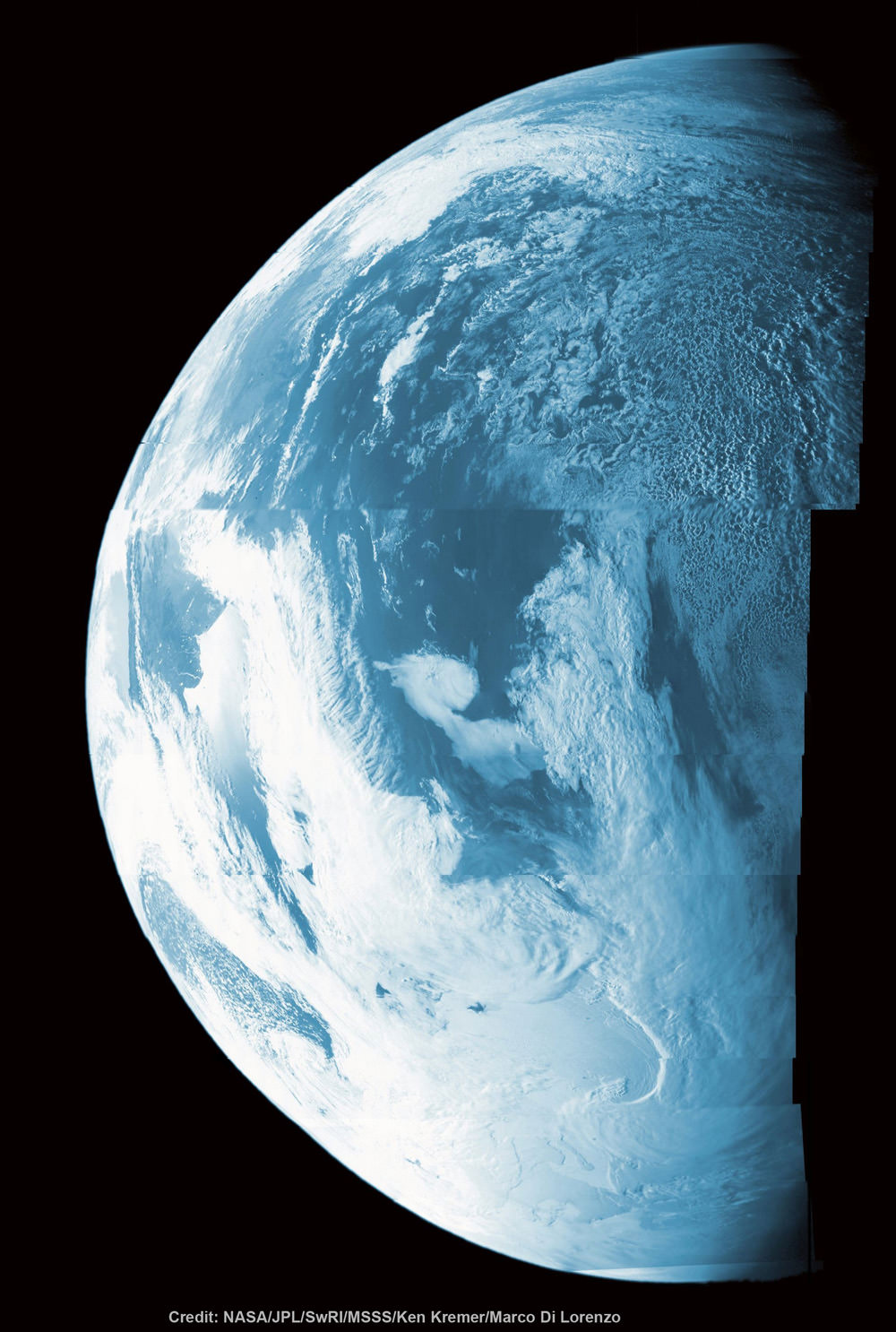
compare to Mariner 10 Earth mosaic above from 1973 to see advances in space technology
This false color composite shows more than half of Earth’s disk over the coast of Argentina and the South Atlantic Ocean as the Juno probe slingshotted by on Oct. 9, 2013 for a gravity assisted acceleration to Jupiter. The mosaic was assembled from raw images taken by the Junocam imager. Credit: NASA/JPL/SwRI/MSSS/Ken Kremer/Marco Di Lorenzo
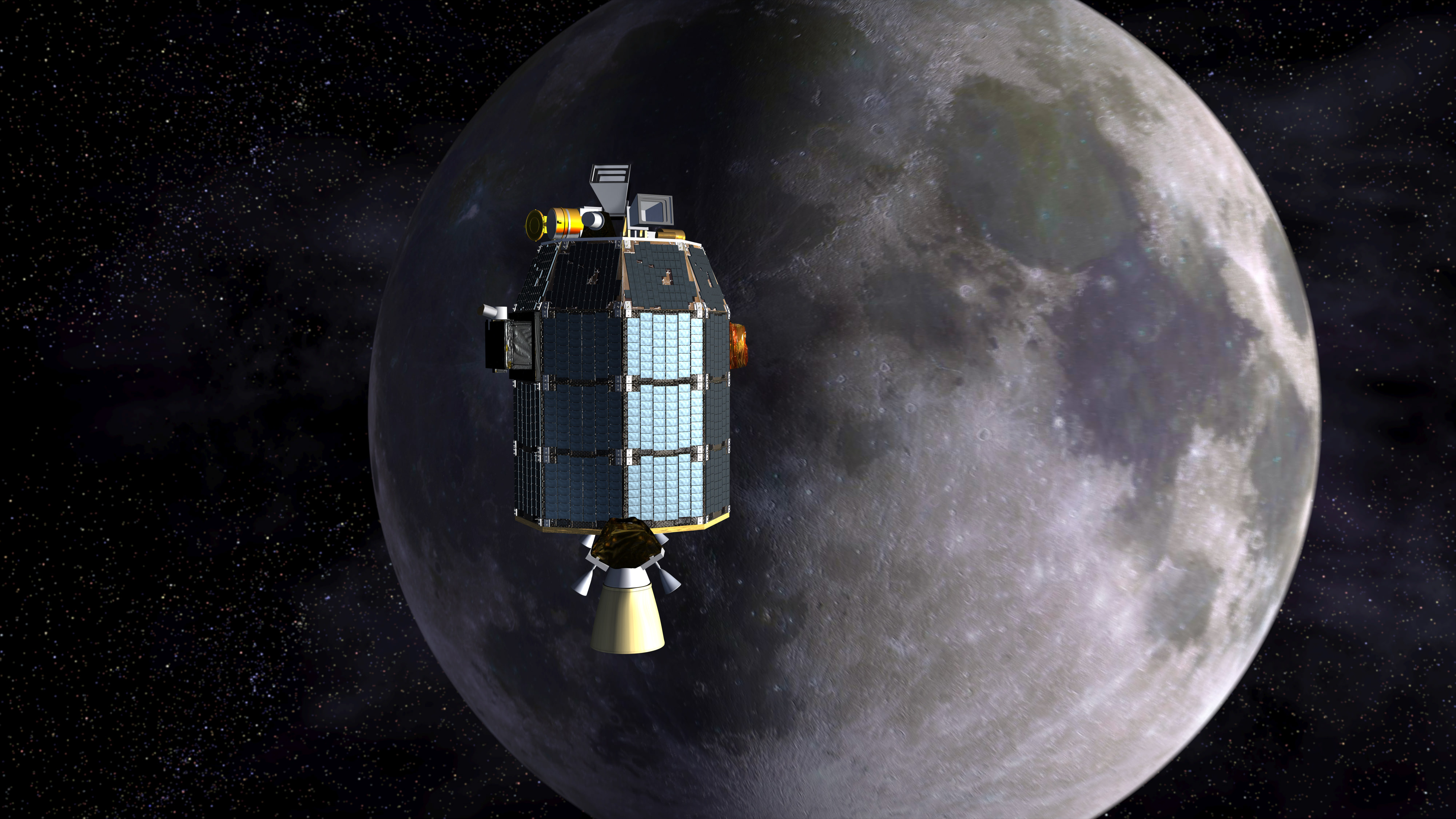
Depiction of NASA's Lunar Atmosphere and Dust Environment Explorer (LADEE) observatory as it approaches lunar orbit.Credit: NASA Ames/Dana Berry
Depiction of NASA’s Lunar Atmosphere and Dust Environment Explorer (LADEE) observatory as it approaches lunar orbit.Credit: NASA Ames/Dana Berry
LADEE will now orbit far lower than ever before – details below![/caption]
LADEE, NASA’s latest lunar orbiter, is getting a new lease on life and will live a little longer to study the mysteries of the body’s tenuous atmosphere, or exosphere, and make surprising new discoveries while hugging Earth’s nearest neighbor even tighter than ever before, the team told Universe Today.
NASA has announced that the Lunar Atmosphere and Dust Environment Explorer (LADEE) mission will be granted a month long extension since the residual rocket fuel is more than anticipated due to the expertise of LADEE’s navigation engineers.
This is great news because it means LADEE’s three research instruments will collect a big bonus of science measurements about the pristine lunar atmosphere and dust during an additional 28 days in an ultra tight low orbit skimming around the Moon.
And the extension news follows closely on the heels of LADEE being photographed in lunar orbit for the first time by a powerful camera aboard NASA’s five year old Lunar Reconnaissance Orbiter (LRO), her orbital NASA sister – detailed here.
This dissolve animation compares the LRO image (geometrically corrected) of LADEE captured on Jan 14, 2014 with a computer-generated and labeled image of LADEE . LRO and LADEE are both NASA science spacecraft currently in orbit around the Moon. Credit: NASA/Goddard/Arizona State University
LADEE is currently flying around the moon’s equator at altitudes ranging barely eight to 37 miles (12-60 kilometers) above the surface which crosses over from lunar day to lunar night approximately every two hours.
During the extended mission lasting an additional full lunar cycle, LADEE will fly even lower to within a few miles (km) thereby allowing scientists an exceptional vantage point to unravel the mysteries of the moon’s atmosphere.
Just how low will LADEE fly?
I asked Rick Elphic, LADEE project scientist at NASA Ames Research Center, Moffett Field, Calif.
“We will be taking LADEE from its nominal 20 to 50 kilometer periapsis right down to the treetops — we want to get data from 5 kilometers or even less!” Elphic told me.
“So far we’ve been keeping a healthy margin for spacecraft safety, but after the nominal mission is completed, we will relax those requirements in the interest of new science.”
With the measurements collected so far the science team has already established a baseline of data for the tenuous lunar atmosphere, or exosphere, and dust impacts, says NASA.
Therefore the LADEE team is free to fly the spacecraft much lower than ever before.
And why even go to lower altitudes? I asked Elphic.
Basically because the team hopes to see changes in the particle density and composition.
“The density depends on the species. For instance, argon-40 is heavier than neon-20, and has a lower scale height. That means we should see a big increase in argon compared to neon.”
“And we may see the heavier species for the first time at these really low altitudes.”
“It’s remotely possible we’ll see krypton, for instance.”
“But the real boon will be in the dust measurements.”
“LDEX (The Lunar Dust Experiment) will be measuring dust densities very close to the surface, and we will see if something new shows up. Each time we’ve dropped our orbit down to lower altitudes, we’ve been surprised by new things,” Elphic told Universe Today.
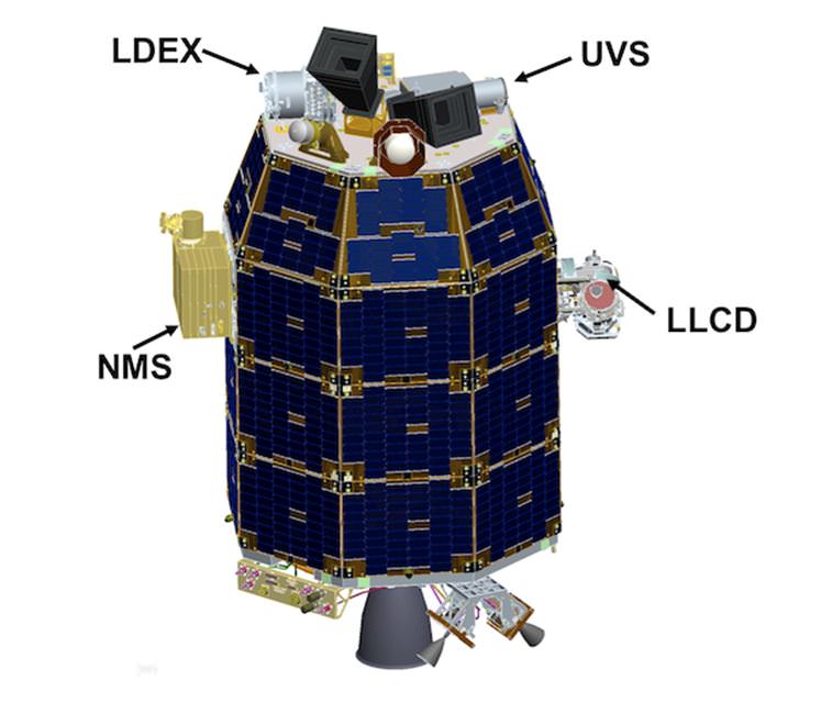
The Neutral Mass Spectrometer (NMS) instrument will measure the identity and abundances of the exospheres constituents, such as argon, neon and krypton.
LADEE Science Instrument locations
With the extension, LADEE is expected to continue capturing data in orbit until about April 21, 2014, depending on the usage of the declining on board fuel to feed its maneuvering thrusters.
“LADEE is investigating the moons tenuous exosphere, trace outgases like the sodium halo and lofted dust at the terminator,” Jim Green, Planetary Science Division Director at NASA HQ, told me earlier in an exclusive interview.
“The spacecraft has a mass spectrometer to identify the gases, a physical dust detector and an imager to look at scattered light from the dust. These processes also occur at asteroids.”
The Lunar Dust Experiment (LDEX) recorded dust impacts as soon as its cover opened, says NASA and is also seeing occasional bursts of dust impacts caused by meteoroid showers, such as the Geminids.
By studying the raised lunar dust, scientists also hope to solve a 40 year old mystery – Why did the Apollo astronauts and early unmanned landers see a glow of rays and streamers at the moon’s horizon stretching high into the lunar sky.
The science mission duration had initially been planned to last approximately 100 days and finish with a final impact on the Moon on about March 24th.
And the team had told me before launch that an extension was rather unlikely since the spacecraft would be flying in such a very low science orbit of about 50 kilometers altitude above the moon that it will require considerable fuel to maintain.
“LADEE is limited by the amount of onboard fuel required to maintain orbit,” Doug Voss, launch manager, Wallops, told me.
So what accounts for the extension?
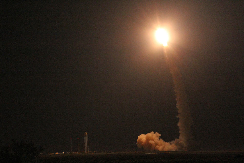
Basically it’s because of the expert navigation by NASA’s engineers and the Orbital Sciences Minotaur V rocket and upper stages following the spectacular night time LADEE blastoff from NASA Wallops, VA, on Sept. 6, 2013 and subsequent insertion into lunar orbit.
“The launch vehicle performance and orbit capture burns using LADEE’s onboard engines were extremely accurate, so the spacecraft had significant propellant remaining to enable extra science,” said Butler Hine, LADEE project manager at NASA’s Ames where the mission was designed, built, tested, in a NASA statement.
“This extension represents a tremendous increase in the amount of science data returned from the mission.”
Launch of NASA’s LADEE lunar orbiter on Friday night Sept. 6, at 11:27 p.m. EDT on the maiden flight of the Minotaur V rocket from NASA Wallops, Virginia, viewing site 2 miles away. Antares rocket launch pad at left. Credit: Ken Kremer/kenkremer.com
“LADEE launched with 134.5 kilograms of fuel. After the third lunar orbit insertion burn (LOI-3), 80% of our fuel had been consumed,” said Dawn McIntosh, LADEE deputy project manager at NASA Ames Research Center, in an exclusive interview with Universe Today.
“Additional orbit-lowering maneuvers with the orbital control system (OCS) and reaction control system (RCS) of approximately 40 seconds were used to get LADEE into the science orbit.
And LADEE’s orbit capture was accomplished amidst the ridiculous US government shutdown with a skeleton crew.
The spacecraft finally entered its planned two hour science orbit around the moon’s equator on Nov. 20.
So LADEE’s orbital lifetime depends entirely on the remaining quantity of rocket fuel.
“LADEE has about 20 kg of propellant remaining today,” Butler Hine told Universe Today.
The 844 pound (383 kg) robot explorer is the size of a couch and was assembled at NASA’s Ames Research Center, Moffett Field, Calif., and is a cooperative project with NASA Goddard Spaceflight Center in Maryland.
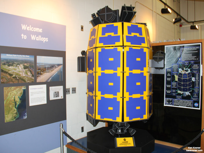
Full scale model of NASA’s LADEE lunar orbiter on display at the free visitor center at NASA’s Wallops Flight Facility in Virginia. Credit: Ken Kremer/kenkremer.com
The $280 million probe is built on a revolutionary ‘modular common spacecraft bus’, or body, that could dramatically cut the cost of exploring space and also be utilized on space probes to explore a wide variety of inviting targets in the solar system.
“LADEE is the first in a new class of interplanetary exploration missions,” NASA Ames Center Director Pete Worden told me in an interview. “It will study the pristine moon to study significant questions.”
“This is probably our last best chance to study the pristine Moon before there is a lot of human activity there changing things.”
To date LADEE has traveled over 1 million miles and in excess of 1200 equatorial orbits around the Moon.
LADEE is also searching for any changes caused to the exosphere and dust by the landing of China’s maiden Chang’e-3 lander and Yutu moon rover in December 2013.
Stay tuned here for Ken’s continuing LADEE, Chang’e-3, Orion, Orbital Sciences, SpaceX, commercial space, Mars rover and more news.
Paul Mahaffy, LADEE Neutral Mass Spectrometer instrument, principal investigator, and Ken Kremer/Universe Today discuss LADEE science at NASA Wallops Flight Facility, VA. Credit: Ken Kremer/kenkremer.com
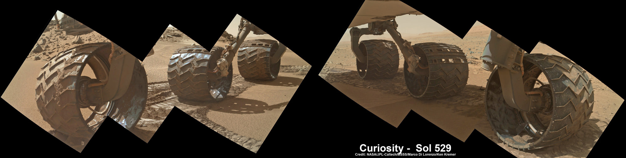
Up close photomosaic view shows lengthy tear in rover Curiosity’s left front wheel caused by recent driving over sharp edged Martian rocks on the months long trek to Mount Sharp. Raw images taken by the MAHLI camera on Curiosity’s arm on Jan. 31, 2014 (Sol 529) were assembled to show some recent damage to several of its six wheels Credit: NASA / JPL / MSSS / Marco Di Lorenzo / Ken Kremer- kenkremer.com See below complete 6 wheel mosaic and further wheel mosaics for comparison
Up close photomosaic view shows lengthy tear in rover Curiosity’s left front wheel caused by recent driving over sharp edged Martian rocks on the months long trek to Mount Sharp. The team is evaluating an alternate, smoother way forward to next science target. Raw images taken by the MAHLI camera on Curiosity’s arm on Jan. 31, 2014 (Sol 529) were assembled to show some recent damage to several of its six wheels.
Credit: NASA / JPL / MSSS / Marco Di Lorenzo / Ken Kremer- kenkremer.com
See below complete 6 wheel mosaic and ‘Dingo Gap’ dune alternate route mosaic plus 3-D view[/caption]
Continuing wheel damage from hoards of sharp edged Martian rocks are forcing engineers to seek a smoother pathway forward – potentially through a treacherous dune field – for NASA’s Curiosity rover on the jagged rock strewn road to Mount Sharp, her primary science destination.
Ever since rover engineers noticed holes and tears to the robots six aluminum wheels this past fall and winter 2013, the team has been photographing the wheels much more frequently and carefully assessing their condition. See our mosaics above and below.
Curiosity’s handlers are now considering diverting the SUV-sized robot to an alternate path crossing into a dune field and the valley beyond that entails traversing through much smoother Martian terrain to reach a highly desirable and nearby science destination called “KMS-9.”
Newly received images taken by the robot only on Friday, Jan. 31, reveal a very significant ragged looking puncture at least 2 to 3 inches (5 to 8 cm) in length and a inch or so (3 cm) wide that’s bent back to the inside of the left front wheel.
Curiosity’s View Past Tall Dune at edge of ‘Dingo Gap’
This photomosaic from Curiosity’s Navigation Camera (Navcam) taken at the edge of the entrance to the Dingo Gap shows a 3 foot (1 meter) tall dune and valley terrain beyond to the west, all dramatically back dropped by eroded rim of Gale Crater. View from the rover’s current position on Sol 528 (Jan. 30, 2014). The rover team may decide soon whether Curiosity will bridge the dune gap as a smoother path to next science destination. Credit: NASA/JPL-Caltech/Marco Di Lorenzo/Ken Kremer- kenkremer.com
See NASA’s 3-D view of Dingo Gap below
Unfortunately, the fields of rough Red Planet rocks have not been a blessing to the 1 ton behemoth.
See our new underbelly mosaic view of Curiosity’s holy wheels (above and below) snapped on Jan. 31, (Sol 529), that’s aimed at the interior and which vividly shows the extent of the injury to the 20 inch diameter wheel.
Photomosaic shows new holes and tears in several of rover Curiosity’s six wheels caused by recent driving over sharp edged Martian rocks on the months long trek to Mount Sharp. Raw images taken by the MAHLI camera on Curiosity’s arm on Jan. 31, 2014 (Sol 529) were assembled to show some recent damage to several of its six wheels. Credit: NASA / JPL / MSSS / Marco Di Lorenzo / Ken Kremer- kenkremer.com
The rate of wheel damage has picked up dramatically as the driving pace accelerated across the rugged, rock filled Martian terrain over the past six months and put over 4.89 kilometers (3.04 mi.) on the odometer to date since the nailbiting August 2012 landing.
The mega robot is now standing at the edge of the dune field by the picturesque entrance known as the “Dingo Gap” after driving another 865 feet (264.7 meters) during January 2014.
You can see the increased damage resulting from the past months drive by comparing the new Sol 529 view with our underbelly mosaic from Sol 490 in December 2013.
Photomosaic shows new holes and tears in several of rover Curiosity’s six wheels caused by recent driving over sharp edged Martian rocks on the months long trek to Mount Sharp. Raw images taken by the MAHLI camera on Curiosity’s arm on Dec. 22, 2013 (Sol 490) were assembled to show some recent damage to several of its six wheels – most noticeably the two here in middle and front. Credit: NASA / JPL / MSSS / Marco Di Lorenzo / Ken Kremer- kenkremer.com
However, the dune cutting across “Dingo Gap” measures about 3 feet (1 meter) in height.
Look at this 3-D “Dingo Gap” mosaic view from NASA and you can judge for yourself the choices the team faces.
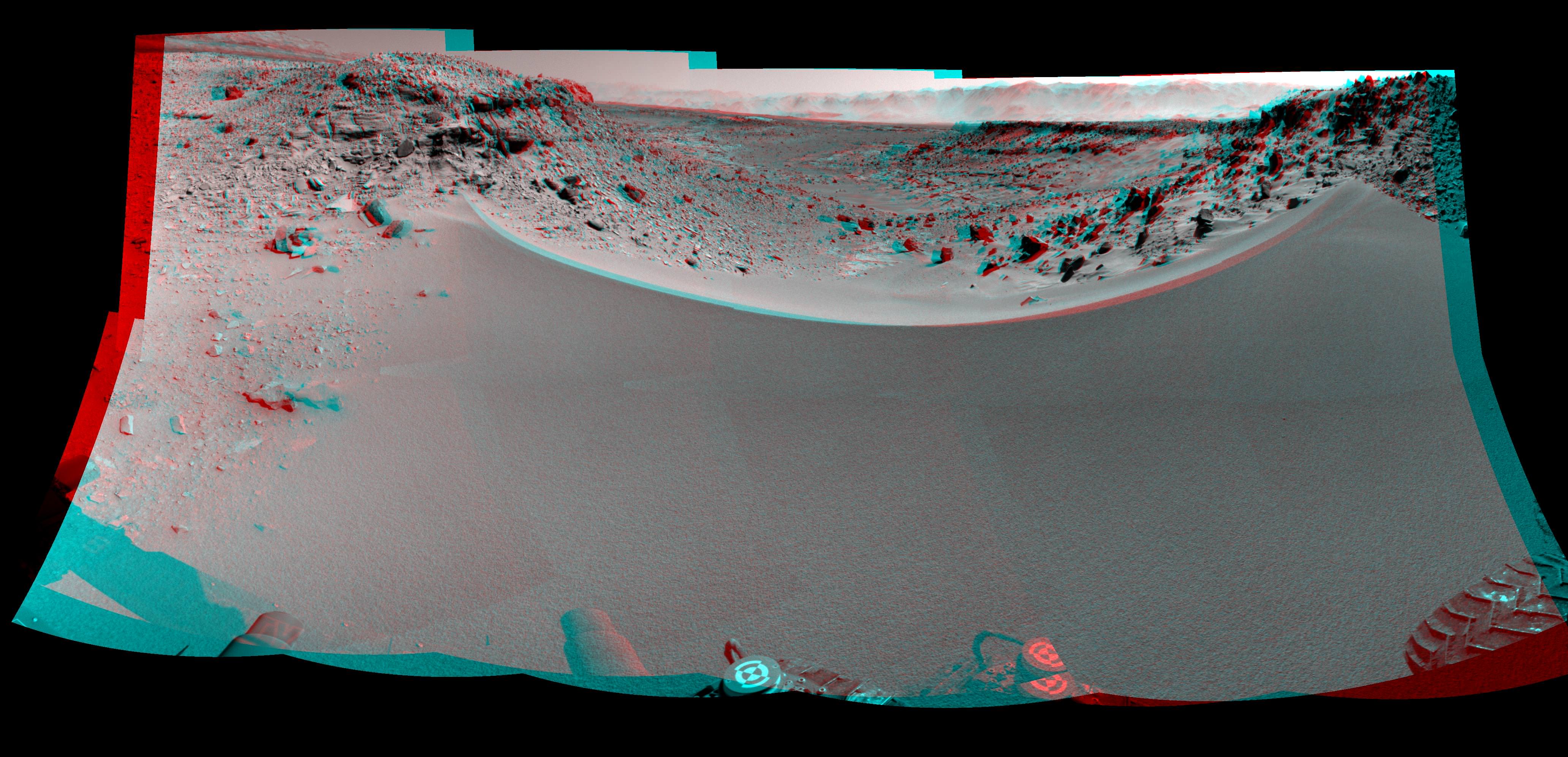
Curiosity’s 3-D View Past Tall Dune at edge of ‘Dingo Gap’
This stereo mosaic of images from the Navigation Camera (Navcam) on Curiosity shows the terrain to the west from the rover’s position on Sol 528 (Jan. 30, 2014). The scene appears three dimensional when viewed through red-blue glasses with the red lens on the left. The view was taken just after Curiosity had arrived at the eastern edge of a location called “Dingo Gap.” A dune across the gap is about 3 feet (1 meter) high in the middle and tapered at south (left) and north (right) ends onto low scarps on either side of the gap. The rover team is evaluating possible driving routes on the other side before a decision whether the cross the gap. Credit: NASA/JPL-Caltech
So the team is evaluating whether that’s safe to bridge because they don’t want to get stuck in a hidden sand trap like the one that ultimately led to Spirit’s demise a few years back.
“The decision hasn’t been made yet, but it is prudent to go check,” said Jim Erickson of NASA’s Jet Propulsion Laboratory, Pasadena, Calif., project manager for Curiosity, in a NASA statement.
Up close view of hole in one of rover Curiosity’s six wheels caused by recent driving over rough Martian rocks. Mosaic assembled from Mastcam raw images taken on Dec. 22, 2013 (Sol 490). Credit: NASA/JPL/MSSS/Ken Kremer -kenkremer.com/Marco Di Lorenzo
“We’ll take a peek over the dune into the valley immediately to the west to see whether the terrain looks as good as the analysis of orbital images implies,” Erickson added, based on orbital images snapped by the High Resolution Imaging Science Experiment (HiRISE) camera on NASA’s Mars Reconnaissance Orbiter (MRO) circling overhead.
The team is also testing an array of different driving techniques to minimize the accumulation of wheel punctures, such as driving backwards or using only four of the six wheels to reduce the force of the wheels pushing against jagged rocks.
The “Dingo Gap” could offer a safer gateway to “KMS-9” along the journey of the rovers southwestwardly route to breathtaking foothills of Mount Sharp.
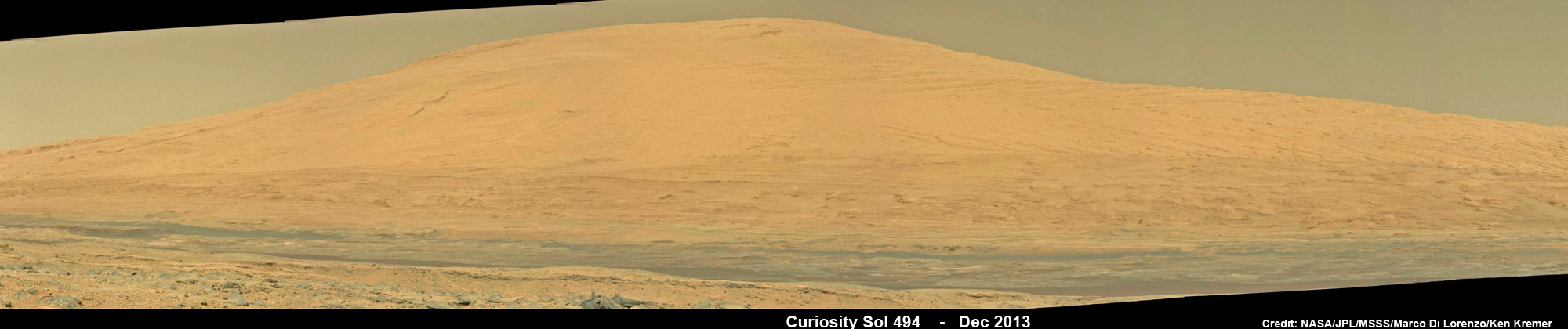
Curiosity Celebrates 500 Sols on Mars on Jan. 1, 2014. NASA’s Curiosity rover snaps fabulous new mosaic spying towering Mount Sharp destination looming dead ahead with her high resolution color cameras, in this cropped view. Imagery assembled from Mastcam raw images taken on Dec. 26, 2013 (Sol 494). Credit: NASA/JPL/MSSS/Marco Di Lorenzo/Ken Kremer- kenkremer.com
Dingo Gap lies between two low scarps and that is tapered off at both sides to the north and south.
KMS-9 is a potentially science rich target where the team hopes to conduct the first rock drilling operations since departing the Yellowknife Bay quadrant in July 2013.
The candidate drilling site lies only about half a mile (800 meters) away as the martian crow flies and features geology that’s appealing to the science team. But the roving routes under consideration are all much farther in actual distance.
“At KMS-9, we see three terrain types exposed and a relatively dust-free surface,” said science team collaborator Katie Stack of the California Institute of Technology, Pasadena.
Curiosity has already accomplished her primary goal of discovering a habitable zone on Mars that could support Martian microbes if they ever existed.
NASA’s rover Curiosity uncovered evidence that an ancient Martian lake had the right chemical ingredients, including clay minerals that could have sustained microbial life forms for long periods of time – and that these habitable conditions persisted on the Red Planet until a more recent epoch than previously thought.
As a result, the science team has shifted the missions focus to include the search for organic molecules – the building blocks of life as we know it – which may be preserved in the sedimentary rock layers of Mount Sharp.
“Really what we’re doing is turning the corner from a mission that is dedicated to the search for habitable environments to a mission that is now dedicated to the search for that subset of habitable environments which also preserves organic carbon,” Curiosity Principal Investigator John Grotzinger, of the California Institute of Technology in Pasadena, said recently at the Dec. 2013 annual meeting of the American Geophysical Union (AGU).
Meanwhile, NASA’s Opportunity rover is exploring clay mineral outcrops by the summit of Solander Point on the opposite side of the Mars at the start of her 2nd Decade investigating the Red Planets mysteries.
Read my new story about the Top 10 Decade 1 discoveries of Spirit and Opportunity – here.
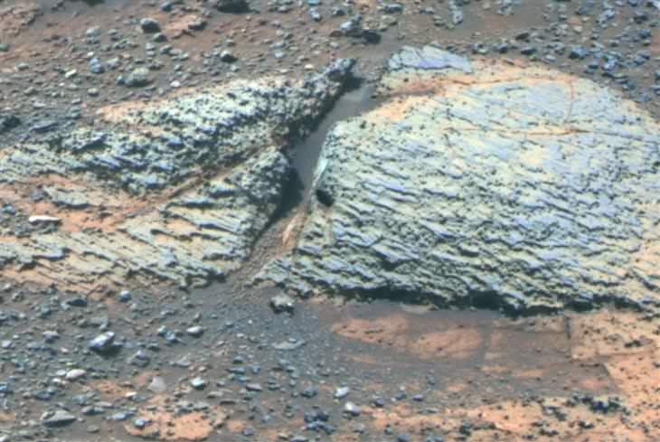
Carbonate-Containing Martian Rocks discovered by Spirit Mars Rover. Spirit collected data in late 2005 which confirmed that the Comanche outcrop contains magnesium iron carbonate, a mineral indicating the past environment was wet and non-acidic, possibly favorable to life. This view was captured during Sol 689 on Mars (Dec. 11, 2005). The find at Comanche is the first unambiguous evidence from either Spirit or Opportunity for a past Martian environment that may have been more favorable to life than the wet but acidic conditions indicated by the rovers' earlier finds. Credit: NASA/JPL-Caltech/Cornell University
A Top 10 Decade 1 Discovery by NASA’s Twin Mars Exploration Rovers
Carbonate-Containing Martian Rocks discovered by Spirit Mars Rover
Spirit collected data in late 2005 which confirmed that the Comanche outcrop contains magnesium iron carbonate, a mineral indicating the past environment was wet and non-acidic, possibly favorable to life. This view was captured during Sol 689 on Mars (Dec. 11, 2005). The find at Comanche is the first unambiguous evidence from either Spirit or Opportunity for a past Martian environment that may have been more favorable to life than the wet but acidic conditions indicated by the rovers’ earlier finds. Credit: NASA/JPL-Caltech/Cornell University Story updated[/caption]
January 2014 marks the 10th anniversary since the nail biting and history making safe landings of NASA’s renowned Mars Explorations Rovers – Spirit and Opportunity – on the Red Planet barely three weeks apart during January 2004.
Due to their completely unforeseen longevity, a decade of spectacular and groundbreaking scientific discoveries continuously flowed from the robot sisters that have graced many articles, magazine covers, books, documentaries and refereed scientific papers.
What are the Top 10 Decade 1 discoveries from Spirit and Opportunity?
Find out below what a top Mars rover team scientist told Universe Today!
Ray Arvidson, the rovers Deputy Principal Investigator and professor at Washington University in St. Louis, has kindly shared with me his personal list of the Top 10 discoveries from Spirit and Opportunity for the benefit of readers of Universe Today.
The Top 10 list below are Ray’s personal choices and does not necessarily reflect the consensus of the Mars Explorations Rover (MER) team.
First some background.
The dynamic duo were launched on their interplanetary voyages from Cape Canaveral Florida atop Delta II rockets during the summer of 2003.
The now legendary pair landed on opposite sides of the Red Planet. Spirit landed first on Jan. 3 inside Gusev Crater and twin sister Opportunity landed second on Jan. 24 on the dusty plains of Meridiani Planum.
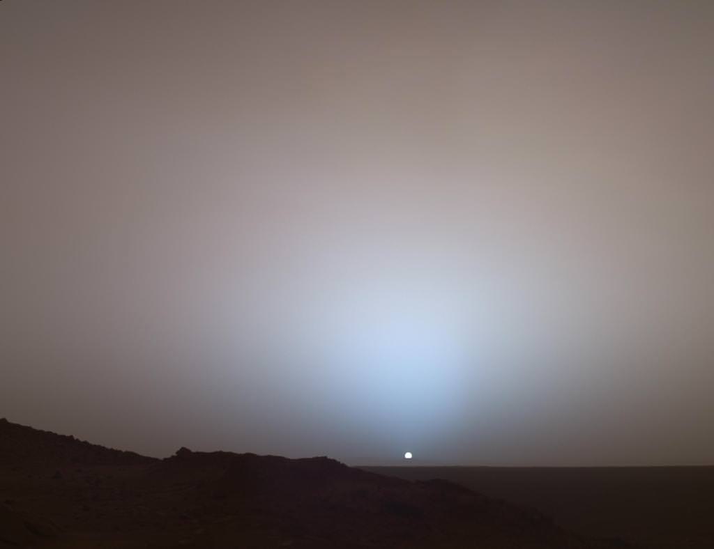
A Moment Frozen in Time
On May 19th, 2005, NASA’s Mars Exploration Rover Spirit captured this stunning view as the Sun sank below the rim of Gusev crater on Mars. This Panoramic Camera (Pancam) mosaic was taken around 6:07 in the evening of Sol 489. The terrain in the foreground is the rock outcrop “Jibsheet,” a feature that Spirit has been investigating for several weeks (rover tracks are dimly visible leading up to “Jibsheet”). The floor of Gusev crater is visible in the distance, and the Sun is setting behind the wall of Gusev some 80 km (50 miles) in the distance. Credit: NASA/JPL-Caltech/Texas A&M/Cornell
The goal was to “follow the water” as a potential enabler for past Martian microbes if they ever existed.
Together, the long-lived, golf cart sized robots proved that early Mars was warm and wet, billions of years ago – a key finding in the search for habitats conducive to life beyond Earth.
The solar powered robo duo were expected to last a mere three months – with a ‘warrenty’ of 90 Martian days (Sols).
Spirit endured the utterly extreme Red Planet climate for more than six years until communications ceased in 2010.
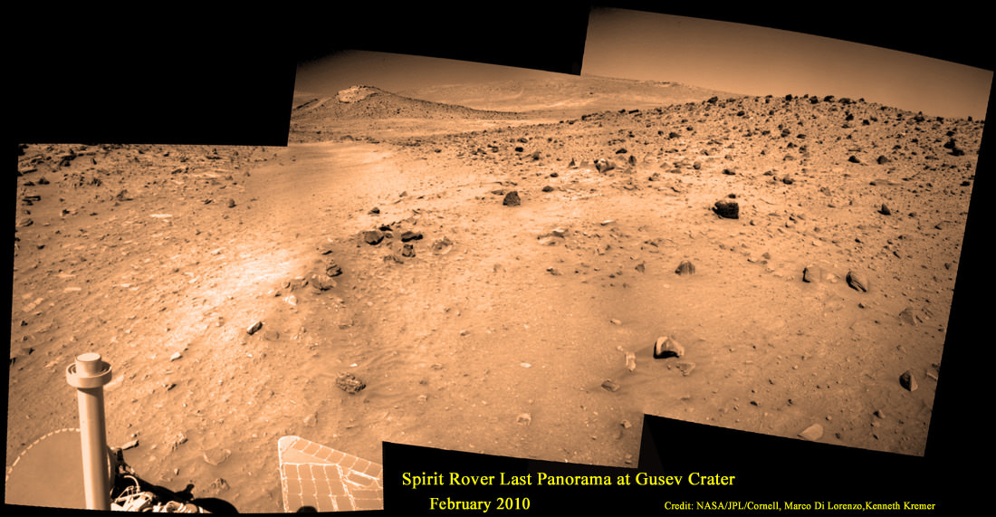
Last View from Spirit rover on Mars
Spirit’s last panorama from Gusev Crater was taken during February 2010 before her death from extremely low temperatures during her 4th Martian winter. Spirit was just 500 feet from her next science target – dubbed Von Braun – at center, with Columbia Hills as backdrop. Mosaic Credit: Marco Di Lorenzo/ Kenneth Kremer/ NASA/JPL/Cornell University.
Mosaic featured on Astronomy Picture of the Day (APOD) on 30 May 2011 – http://apod.nasa.gov/apod/ap110530.html
Opportunity lives on TODAY and is currently exploring by the summit of Solander Point on the western rim of a vast crater named Endeavour that spans some 22 kilometers (14 miles) in diameter.
“Because of the rovers’ longevity, we essentially got four different landing sites for the price of two,” says the rovers’ Principal Investigator, Steve Squyres of Cornell University, Ithaca, N.Y.
Here are the Top 10 MER discoveries from Ray Arvidson, Deputy Principal Investigator
1. Opportunity: Ancient Acidic Martian Lakes
The Meridiani plains Burns formation as sulfate-rich sandstones with hematitic concretions formed in ancient acidic and oxidizing shallow lakes and reworked into sand dunes and cemented by rising groundwaters.
‘Burns Cliff’ Color Panorama Opportunity captured this view of “Burns Cliff” after driving right to the base of this southeastern portion of the inner wall of “Endurance Crater.” The view combines frames taken by Opportunity’s panoramic camera between the rover’s 287th and 294th martian days (Nov. 13 to 20, 2004). The mosaic spans more than 180 degrees side to side. Credit: NASA/JPL-Caltech/Cornell
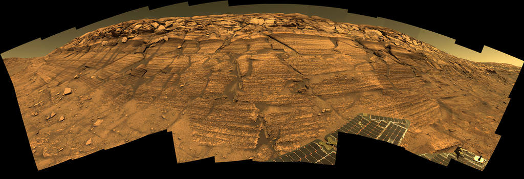
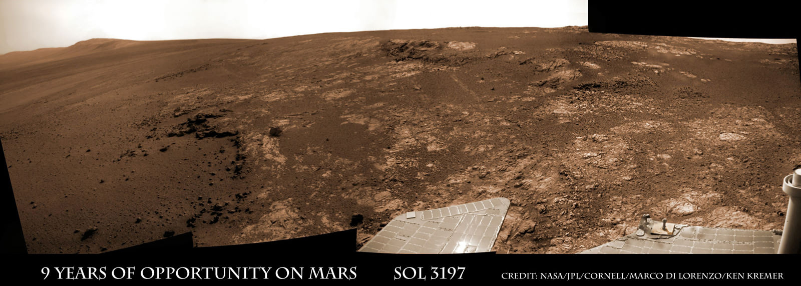
2. Opportunity: Phyllosilicate Clays at ‘Whitewater Lake’ at Endeavour Crater indicate Ancient Habitable Zone
At the rim of Endeavour crater and the Cape York rim segment the discovery of ferric and aluminous smectite [phyllosilicate] clays in the finely-layered Matijevic formation rocks that pre-exist the Endeavour impact event.
Pancam false-color view acquired on Sol 3066 (Sept. 8 2012) of fine-scale layering in the Whitewater Lake locality that is indicative of an ancient aqueous environment on Mars. Veneers have been resistant to wind erosion and enhanced the layered appearance of the outcrop. Layers are typically several millimeters thick. Credit: NASA/JPL-Caltech/Cornell/Arizona State University
Alteration in moderately acidic and reducing waters, perhaps mildly oxidizing for ferric smectites. These are the oldest rocks examined by Opportunity and the waters are much more habitable than waters that led to Burns formation.
Opportunity rover discovered phyllosilicate clay minerals and calcium sulfate veins at the bright outcrops of ‘Whitewater Lake’, at right, imaged by the Navcam camera on Sol 3197 (Jan. 20, 2013, coinciding with her 9th anniversary on Mars. “Copper Cliff” is the dark outcrop, at top center. Darker “Kirkwood” outcrop, at left, is site of mysterious “newberries” concretions. This panoramic view was snapped from ‘Matijevic Hill’ on Cape York ridge at Endeavour Crater. Credit: NASA/JPL-Caltech/Cornell/Marco Di Lorenzo/Ken Kremer
3. Opportunity: Martian Meteorites
Many meteorites were found [throughout the long traverse] that are dispersed across the Meridiani plains landing site
4. Opportunity: Wind-blown sand ripples
Wind-blown sand ripples throughout the Meridiani plains relict from the previous wind regime, probably when Mars spin axis tilt was different than today’s value
5. Spirit: Opaline silica indicates Ancient Hydrothermal system
Discovery of Opaline silica at Home Plate, Gusev Crater. This formed in volcanic fumeroles and/or hydrothermal vents indicating that water was interacting with magma.
Spirit acquired this mosaic on Sol 1202 (May 21, 2007), while investigating the area east of the elevated plateau known as “Home Plate” in the “Columbia Hills.” The mosaic shows an area of disturbed soil, nicknamed “Gertrude Weise” by scientists, made by Spirit’s stuck right front wheel. The trench exposed a patch of nearly pure silica, with the composition of opal. It could have come from either a hot-spring environment or an environment called a fumarole, in which acidic, volcanic steam rises through cracks. Either way, its formation involved water, and on Earth, both of these types of settings teem with microbial life. Credit: NASA/JPL-Caltech/Cornell
6. Spirit: Carbonates at Comanche – see lead image above
The discovery of Fe-Mg [iron-magnesium] carbonates at the Comanche outcrop on Husband Hill, Gusev Crater, again showing that water interacted with magma.
Note: Carbonates form in neutral, non-acid water. This was the first time they were found and investigated examined on the surface Mars during Dec. 2005.
7. Spirit: Ferric sulfates moved by modern water
Ferric sulfates moved down the soil column by modern waters at Troy and Husband Hill in Gusev Crater.
‘Calypso’ Panorama of Spirit’s View from ‘Troy’. This full-circle view from the panoramic camera (Pancam) on NASA’s Mars Exploration Rover Spirit shows the terrain surrounding the location called “Troy,” where Spirit became embedded in soft soil during the spring of 2009. The hundreds of images combined into this view were taken beginning on the 1,906th Martian day (or sol) of Spirit’s mission on Mars (May 14, 2009) and ending on Sol 1943 (June 20, 2009). Credit: NASA/JPL-Caltech/Cornell University
8. Spirit: Modern water alters rocks
Complex coatings on olivine basalts on the Gusev Crater plains showing modern water or frost has altered rock surfaces
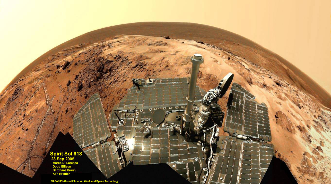
9. Both rovers: Martian Dust Devils
The finding [and imaging] of dust devil frequency and dynamics, showing how dust and sand are moved by wind in the very thin Martian atmosphere.
Note: Wind action occasionally cleaning off the solar panels led to their unexpected longevity
See a dust devil imaged in our Solander Point mosaic below
Spirit Mars rover – view from Husband Hill summit – panels cleaned by wind action
Spirit snapped this unique self portrait view from the summit of Husband Hill inside Gusev crater on Sol 618 on 28 September 2005. The rovers were never designed or intended to climb mountains. It took more than 1 year for Spirit to scale the Martian mountain. This image was created from numerous raw images by an international team of astronomy enthusiasts and appeared on the cover of the 14 November 2005 issue of Aviation Week & Space Technology magazine and the April 2006 issue of Spaceflight magazine. Also selected by Astronomy Picture of the Day (APOD) on 28 November 2005. Credit: NASA/JPL/Cornell/ Marco Di Lorenzo/Doug Ellison/Bernhard Braun/Ken Kremer – kenkremer.com
10. Both rovers: Atmospheric Argon measurements
Argon gas was used as a tracer of atmospheric dynamics by both rovers. It was measured by using the APXS (Alpha Particle X-Ray Spectrometer) on the robotic arm to measure the Martian atmosphere and detect argon
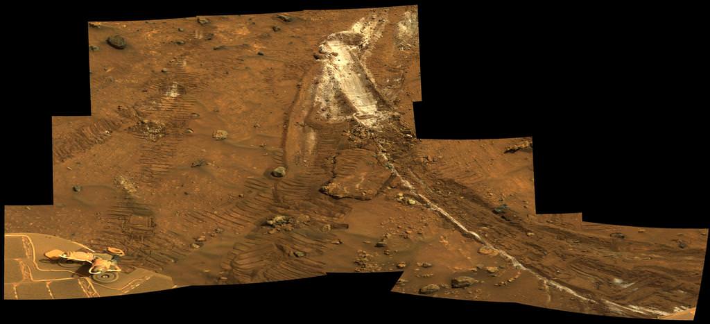
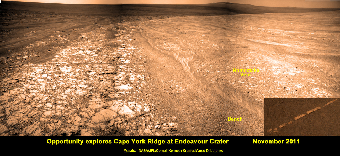
Another major discovery by Opportunity was the finding of hydrated mineral veins of calcium sulfate in the bench surrounding Cape York. The vein discovery is another indication of the ancient flow of liquid water in this region on Mars.
Opportunity discovers hydrated Mineral Vein at Endeavour Crater – November 2011. Opportunity determined that the ‘Homestake’ mineral vein was composed of calcium sulfate,or gypsum, while exploring around the base of Cape York ridge at the western rim of Endeavour Crater. The vein discovery indicates the ancient flow of liquid water at this spot on Mars. This panoramic mosaic of images was taken on Sol 2761, November 2011, and illustrates the exact spot of the mineral vein discovery. Featured on NASA Astronomy Picture of the Day (APOD) on 12 Dec 2011 – http://apod.nasa.gov/apod/ap111212.html. Credit: NASA/JPL/Cornell/Kenneth Kremer/Marco Di Lorenzo.
Altogether, Spirit snapped over 128,000 raw images, drove 4.8 miles (7.7 kilometers) and ground into 15 rock targets.
Opportunity is currently investigating a new cache of exposed clay mineral outcrops by the summit of Solander Point, a rim segment just south of Cape York and Matejivic Hill.
These new outcrops at ‘Cape Darby’ like those at ‘Esperance’ at Matijevic Hill were detected based on spectral observations by the CRISM spectrometer aboard NASA’s Mars Reconnaissance Orbiter (MRO) circling overhead, Arvidson told me.
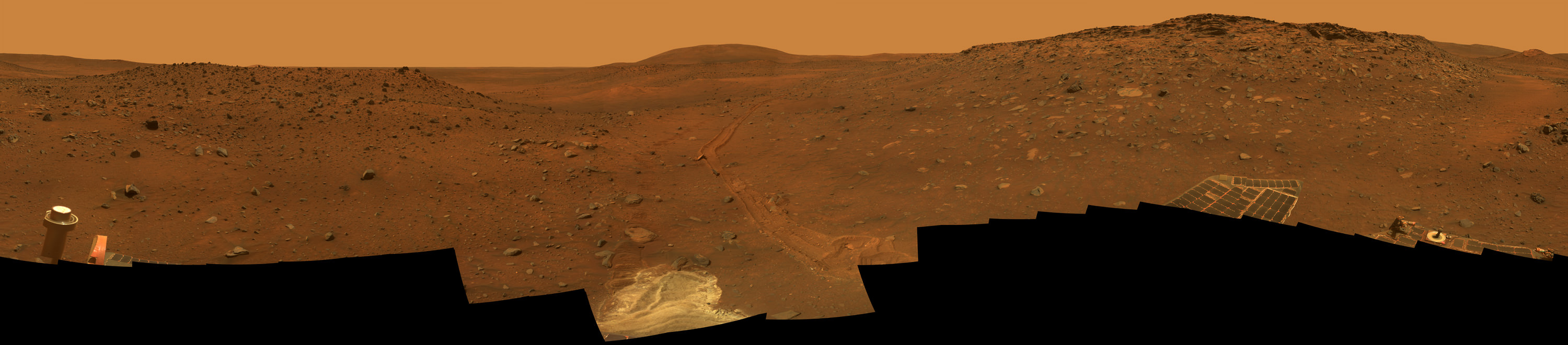
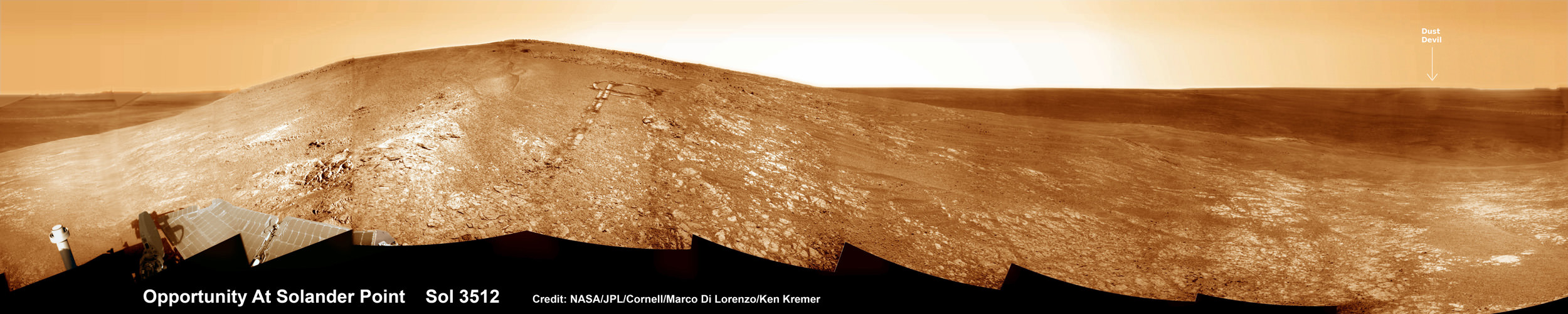
Opportunity by Solander Point peak – 2nd Mars Decade Starts here!
NASA’s Opportunity rover captured this panoramic mosaic on Dec. 10, 2013 (Sol 3512) near the summit of “Solander Point” on the western rim of vast Endeavour Crater where she starts Decade 2 on the Red Planet. She is currently investigating summit outcrops of potential clay minerals formed in liquid water on her 1st mountain climbing adventure. See wheel tracks at center and dust devil at right. Assembled from Sol 3512 navcam raw images. Credit: NASA/JPL/Cornell/Marco Di Lorenzo/Ken Kremer-kenkremer.com
Today, Jan. 31, marks Opportunity’s 3563rd Sol or Martian Day roving Mars – for what was expected to be only a 90 Sol mission.
So far she has snapped over 188,200 amazing images on the first overland expedition across the Red Planet.
Her total odometry stands at over 24.07 miles (38.73 kilometers) since touchdown on Jan. 24, 2004 at Meridiani Planum.
Meanwhile on the opposite side of Mars, Opportunity’s younger sister rover Curiosity is trekking towards gigantic Mount Sharp. She celebrated 500 Sols on Mars on New Years Day 2014.
What’s Ahead for Opportunity in Decade 2 on Mars ?
Many more ground breaking discoveries surely lie ahead for Opportunity since she is currently exploring ancient terrain at Endeavour crater that’s chock full of minerals indicative of a Martian habitable zone.
She remains healthy and the solar panels are generating enough power to actively continue science investigations throughout her 6th frigid Martian winter!
NASA’s Opportunity Mars rover recorded the component images for this self-portrait near the peak of Solander Point and about three weeks before completing a decade of work on Mars. The rover’s panoramic camera (Pancam) took the images during the interval Jan. 3, 2014, to Jan. 6, 2014. Credit: NASA/JPL-Caltech/Cornell/Arizona State University
Therefore – Stay tuned here for Ken’s continuing Opportunity, Curiosity, Chang’e-3, LADEE, MAVEN, Mars rover and MOM news.
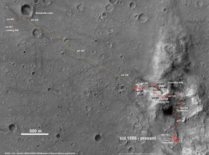
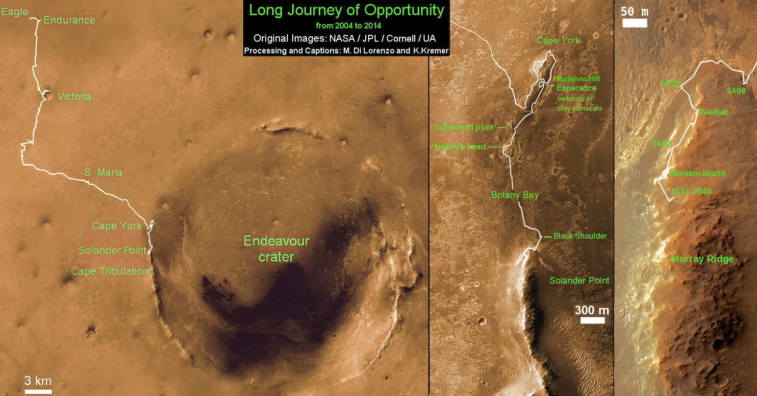
Spirit Rover traverse map from Gusev Crater landing site to Home Plate: 2004 to 2011Traverse Map for NASA’s Opportunity rover from 2004 to 2014
This map shows the entire path the rover has driven during a decade on Mars and over 3560 Sols, or Martian days, since landing inside Eagle Crater on Jan 24, 2004 to current location by Solander Point summit at the western rim of Endeavour Crater. Rover will spend 6th winter here atop Solander. Opportunity discovered clay minerals at Esperance – indicative of a habitable zone. Credit: NASA/JPL/Cornell/ASU/Marco Di Lorenzo/Ken Kremer – kenkremer.com
The "rocket sled" that is a part of the Low-Density Supersonic Decelerator Project testing methods to slow spacecraft before they land. Credit: NASA
Watch the video above to the two-minute mark (and beyond) and we guarantee a brilliant start to your Friday. “Enter Sandman” indeed, Metallica. Look past the flames and thrust, however, and you will see a parachute test in action that could help spacecraft land safely on Mars one day.
This is an undated “rocket sled” test of the Low-Density Supersonic Decelerator, a technology aiming to be a more advanced way to bring spacecraft to Mars besides the 1970s-era Viking parachutes that were used as late as the Curiosity mission.
And supersonic flight tests of this technology will take place this year and next, according to NASA. The technology could be used on spacecraft as early as 2018, the agency added.
“NASA seeks to use atmospheric drag as a solution, saving rocket engines and fuel for final maneuvers and landing procedures,” the agency states on the project’s web page. “The heavier planetary landers of tomorrow, however, will require much larger drag devices than any now in use to slow them down — and those next-generation drag devices will need to be deployed at higher supersonic speeds to safely land vehicle, crew and cargo.”
“One of the tests on my LDSD project, which combines the Navy version of a Blackhawk helicopter, a giant 110 foot parachute, 3000 pounds of rope, a very big pulley, four rockets, and a railroad track in the desert. The test successfully uncovered a design flaw in the parachute before we flew one like it on a much more expensive test — which is exactly what this test was for,” wrote collaborator Mark Adler (a fellow at the Jet Propulsion Laboratory who was a mission manager for the Spirit rover) on Google Plus.
As part of this project, NASA is testing three devices. The first is a huge parachute (30.5 meters, or 100 feet) that will deploy when the spacecraft is at about 1.5 to 2 times the speed of sound to slow it down.
NASA’s Curiosity rover heads for a successful landing Aug. 6 under its parachute. Picture snapped by NASA’s Mars Reconnaissance Orbiter’s High-Resolution Imaging Science Experiment (HiRISE). Credit: NASA/JPL-Caltech/Univ. of Arizona
At faster speeds, NASA also plans inflatable aerodynamic decelerators, which it describes as “very large, durable, balloon-like pressure vessels.” These devices are being tested in two versions: six-meter and eight-meter (19.7 feet and 26.2 feet). They are designed to balloon around the spacecraft to slow it down from 3.5 times the speed of sound to at least twice the speed of sound, if not lower.
“All three devices will be the largest of their kind ever flown at speeds several times greater than the speed of sound,” NASA stated.
The project is a NASA technology demonstration mission led by the Jet Propulsion Laboratory. This test and similar ones were conducted at the conducted at the U.S. Naval Air Weapons Station at China Lake, Calif. More videos and information are available at LDSD’s webpage.
Huge hat-tip to @marsroverdriver for highlighting this on his Twitter account yesterday (Thursday).


![MER10-SpiritAndOpportunity_ByTheNumbers[1]](https://www.universetoday.com/wp-content/uploads/2014/01/MER10-SpiritAndOpportunity_ByTheNumbers1.jpg)


