The Netflix movie Don’t Look Up received plenty of accolades for its scarily realistic portrayal of a professor from Michigan State University attempting to warn the world about a civilization-ending asteroid impact. In reality, there are plenty of organizations in the US government and beyond whose job it is to find and avoid those impacts. And the best way to train them to do those jobs is to run scenarios and try to determine what actions would need to be taken. That was the idea behind the fifth Planetary Defense Interagency Tabletop Exercise, held at John Hopkins University Applied Physics Laboratory in April. NASA recently released a preliminary report on the results of the exercise, with a fully detailed one to come in August.
Continue reading “NASA Imagines a Catastrophic Asteroid Impact to Study How to Prevent it”Here's How NASA is Planning to Protect Earth From Asteroids and Comets
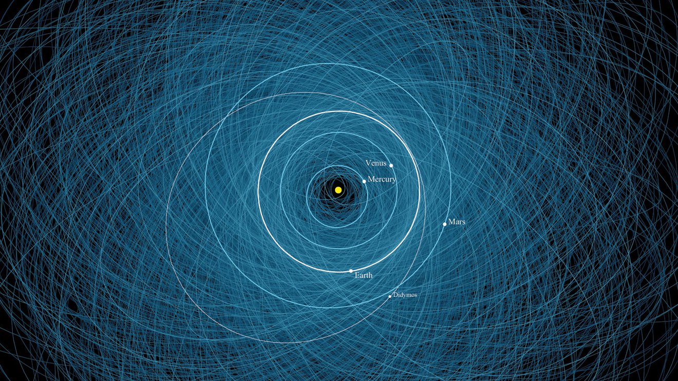
The large impact craters dotting our planet are powerful reminders that asteroids and comets strike the Earth from time to time. As often said, it’s not a question of “if”; it’s a matter of “when” our planet will face an impending strike from space. But an impact is one existential threat humanity is finally starting to take seriously and wrap its head around.
Seemingly spurred by the success of the Double Asteroid Redirection Test (DART), NASA just released a new planetary defense strategy and action plan, describing its efforts to find and identify potentially hazardous objects to provide an advanced warning, and then even push them off an impact trajectory.
This 10-year strategy looks to advance efforts to protect the Earth from a devastating encounter with a Near Earth asteroid or comet.
Continue reading “Here's How NASA is Planning to Protect Earth From Asteroids and Comets”Gaze Down Into the eye of Hurricane Ian, Seen From Orbit
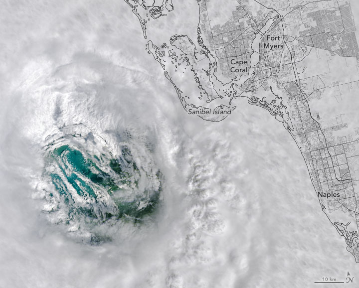
NASA and NOAA satellites — as well as astronauts on the ISS — captured some stunning imagery of Hurricane Ian, as seen from orbit. Our lead image shows an eerie view of the hurricane’s eye on September 28. The Landsat 8 satellite passed directly over Ian’s eye as the storm approached southwest Florida.
Continue reading “Gaze Down Into the eye of Hurricane Ian, Seen From Orbit”The Recent Killer Tornado’s Track is Visible From Space
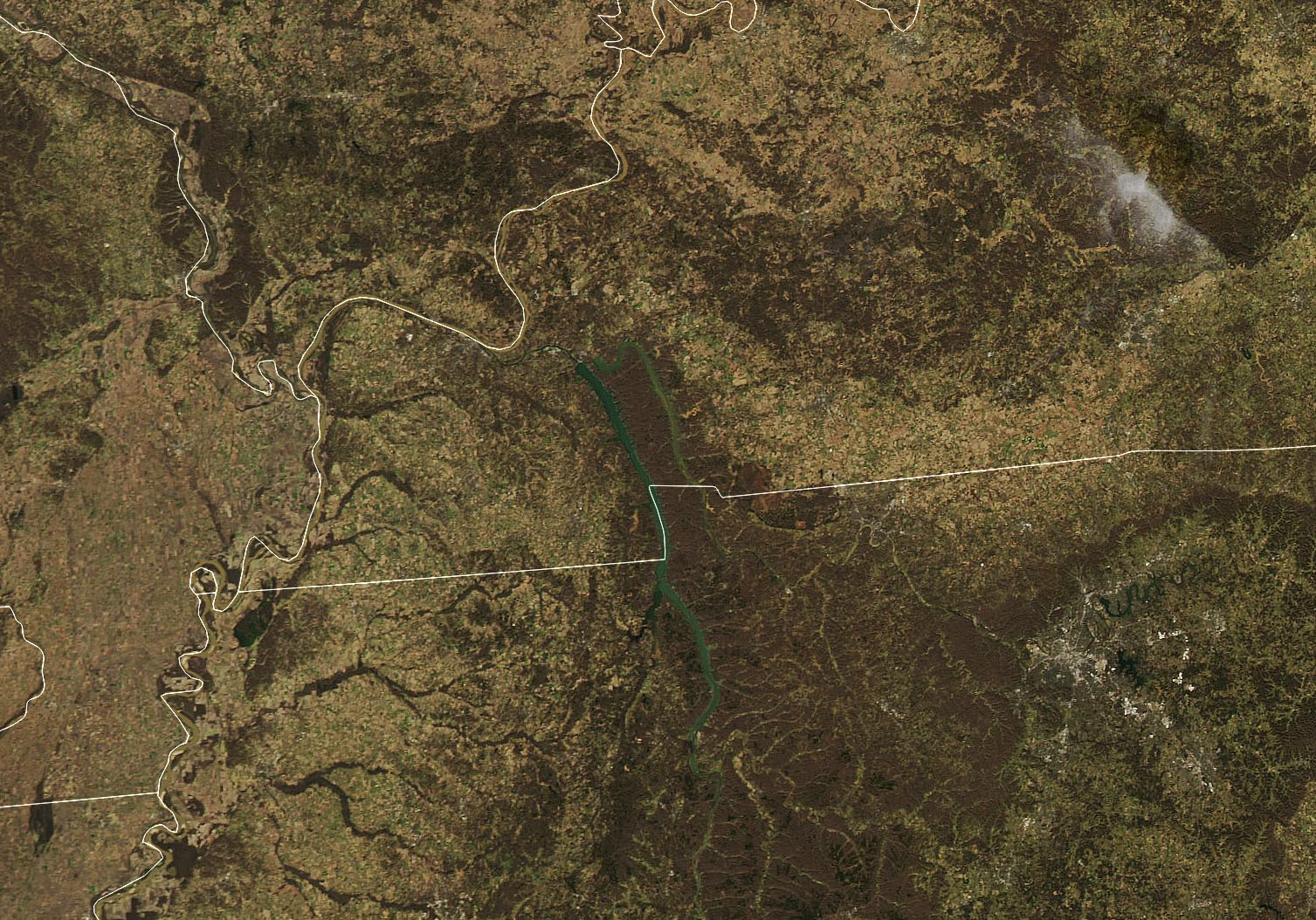
During the night of December 10, 2021, severe weather tore through several US states, Arkansas, Illinois, Kentucky, Mississippi, Missouri and Tennessee. At least 70 tornado-like events were reported, and one storm cell was tracked on radar for approximately four hours as it traveled for more than 400 km (250 miles.)
While the destruction these storms left behind is visible even from space, the heartbreaking devastation on the ground is sobering; over 100 people killed, with hundreds more injured.
Continue reading “The Recent Killer Tornado’s Track is Visible From Space”KSC and Visitor Complex Reopen in Aftermath of Hurricane Irma; with Launches Delayed and Viewing Spots Destroyed: Gallery
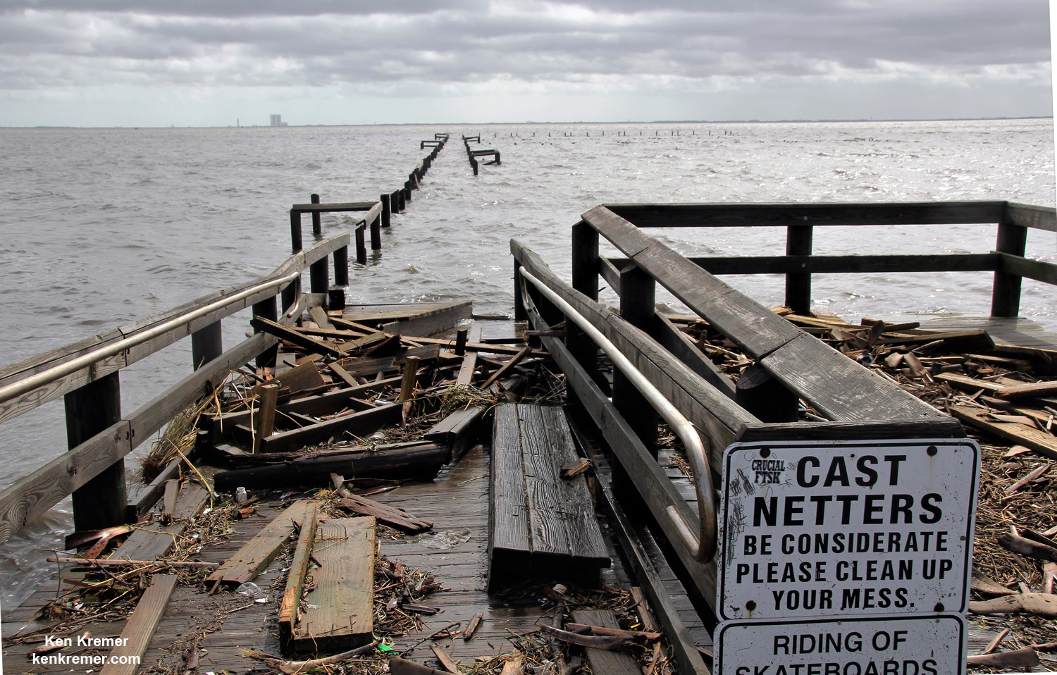

TITUSVILLE/CAPE CANAVERAL, FL – NASA’s Kennedy Space Center, the KSC Visitor Complex and Cape Canaveral Air Force Station have reopened as of today (Sept. 16) and yesterday, respectively, in the aftermath of Cat 1 hurricane force winds from Hurricane Irma that lashed the Florida Space Coast on Saturday, Sunday and Monday (Sept. 9/10/11) – forcing launch delays and leaving damaged and destroyed homes, buildings, infrastructure and launch viewing locations in its wake – see photos.
Cape Canaveral Air Force Station military forces partially reopened certain critical runways hours after Irma swept by the space coast to assist in emergency recovery operations.
“Kennedy Space Center will resume normal operations Saturday, Sept. 16,” NASA announced. “The “All Clear” has been given to reopen.”
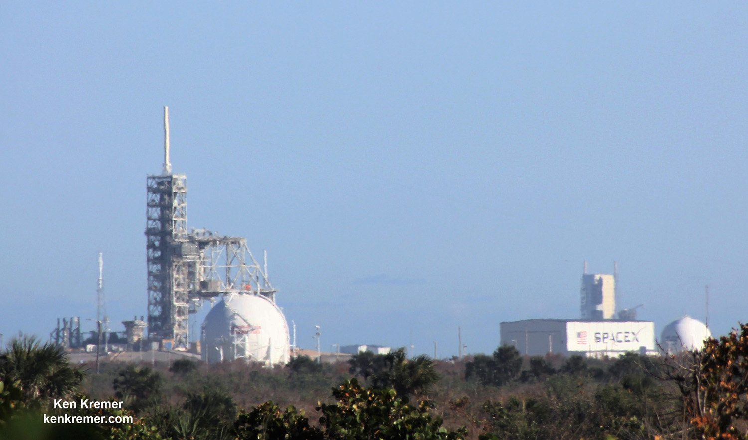
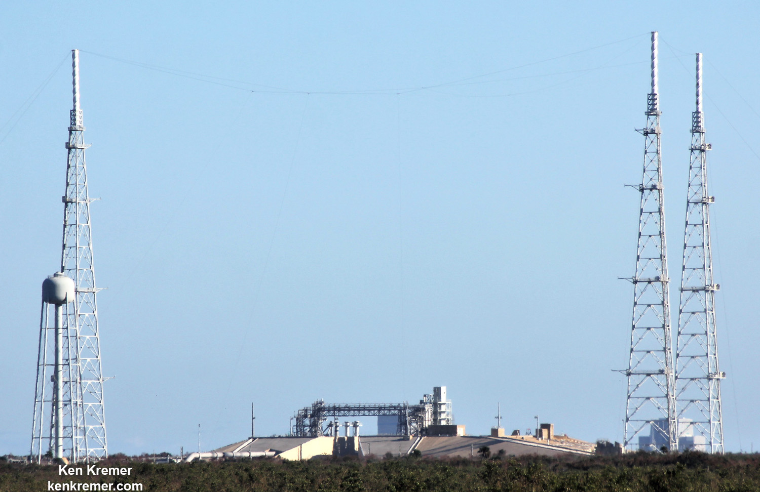
NASA’s world famous Vehicle Assembly Building and the Space Coast launch pads are still standing – as seen in photos from myself and more from NASA.
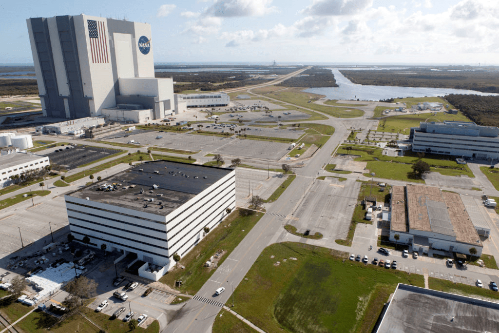
“As you’ve all seen by now, the Center will be open for normal operations at midnight tonight, and we’ll be ready to get back into the full swing of things Monday morning,” KSC Center Director Bob Cabana said in a message to employees.
Hurricane Irma knocked out water and power to KSC, the Cape, the visitor complex and the barrier islands including Merritt Island which is home to America’s premier Spaceport.
Wind speeds at KSC “varied from 67-94 mph (59-82 knots) at the 54-foot level to 90-116 mph (79-101 knots) at the 458-foot level during the storm.”
As a direct result of Irma, the next Space Coast launches of a United Launch Alliance Atlas V and SpaceX Falcon 9 has been postponed into October.
“The storm did delay the next launches,” said Brig. Gen. Wayne R. Monteith, Commander, 45th Space Wing, at a media briefing.
“We think the next launch will be approximately the first week of October.”
However although there was damage to a numerous buildings, both the spacecraft and rockets are safe and sound.
“The spacecraft we have on station right now are healthy and are being monitored.”
“The seven rocket boosters [Atlas, Falcon, Delta IV Heavy] we have on the Cape rode out the storm just fine,” Montieth elaborated.
The base and the visitor complex both lacked potable water service used for drinking, food preparation and cleaning.
Multiple water pipes in the nearby community of Cocoa were severed. KSC, the Cape and the Visitor Center as well as the surrounding community were under a boil water restriction for several days.
“Full water service is now available and the center has received an all clear following several days of closure related to Hurricane Irma,” noted KSC officials.
Indeed over 87% of customers lost power in Brevard County – home to the Florida Space Coast. Over 2/3 of customers lost power throughout Florida- impacting over 16 million people.
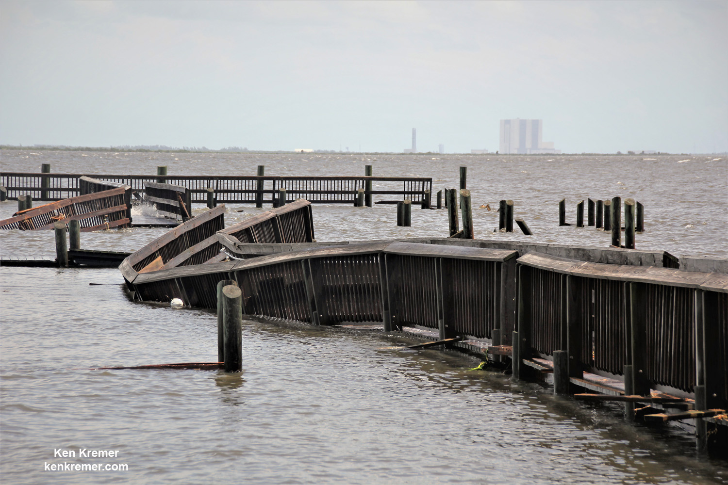
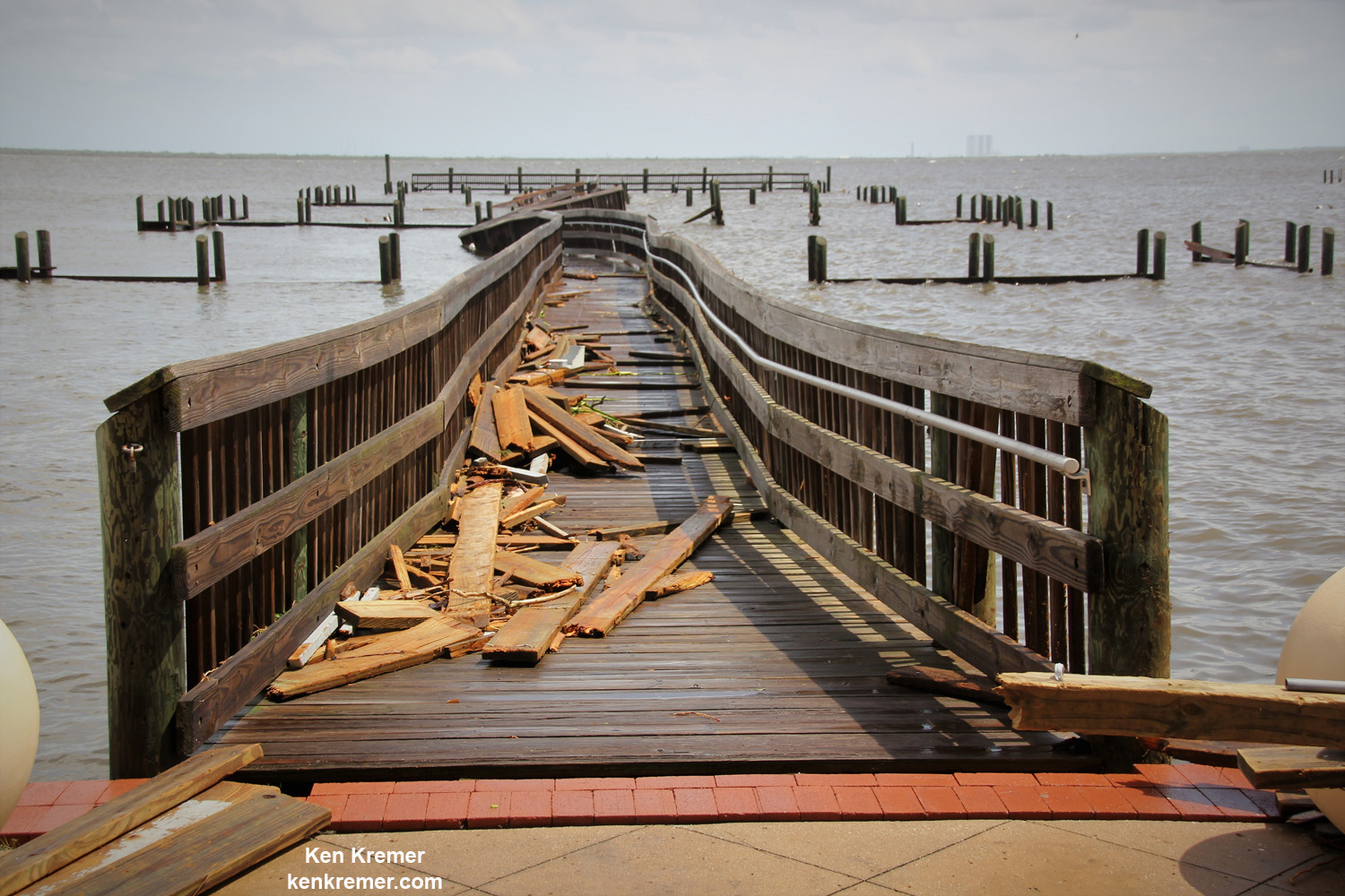
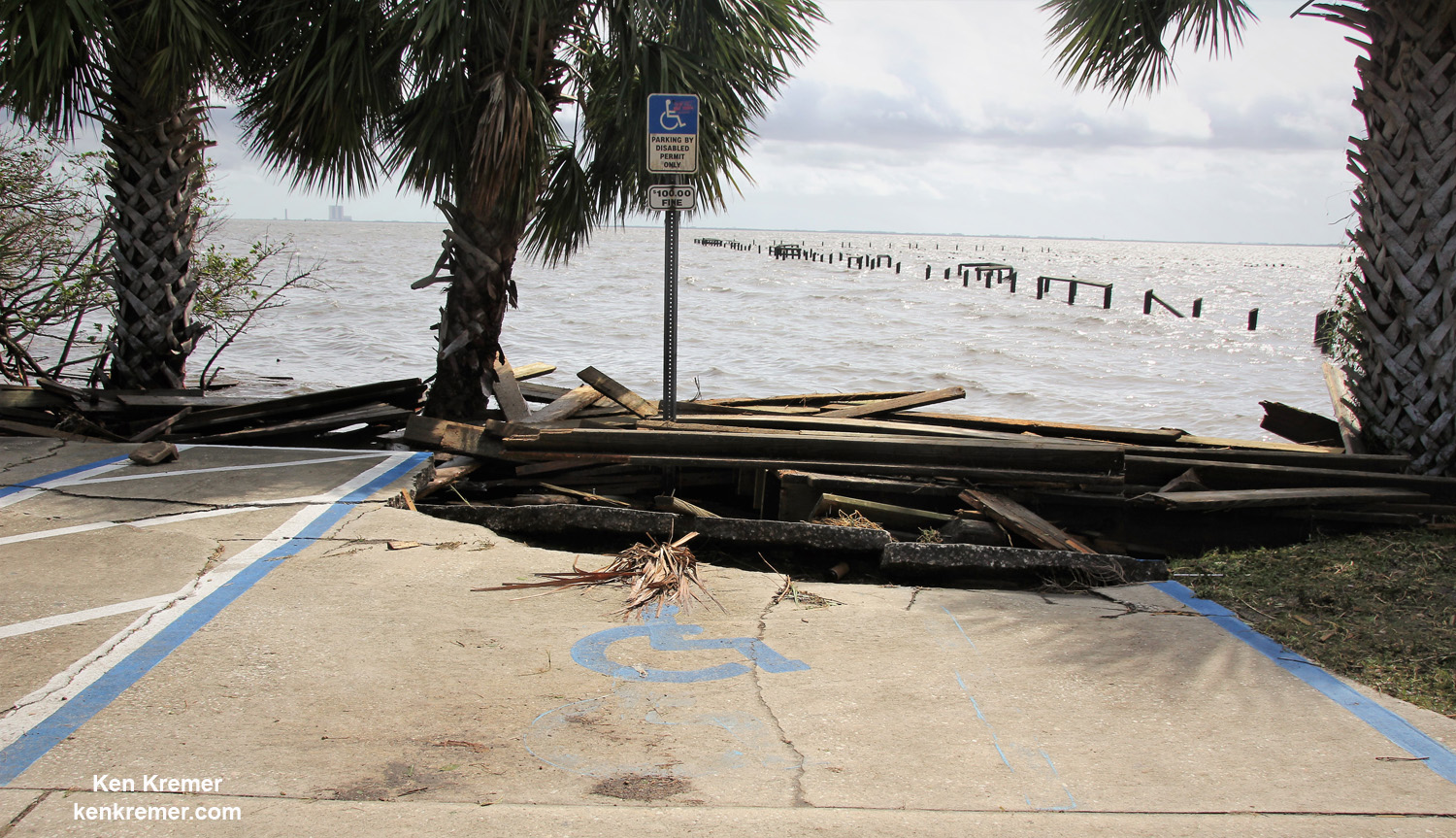
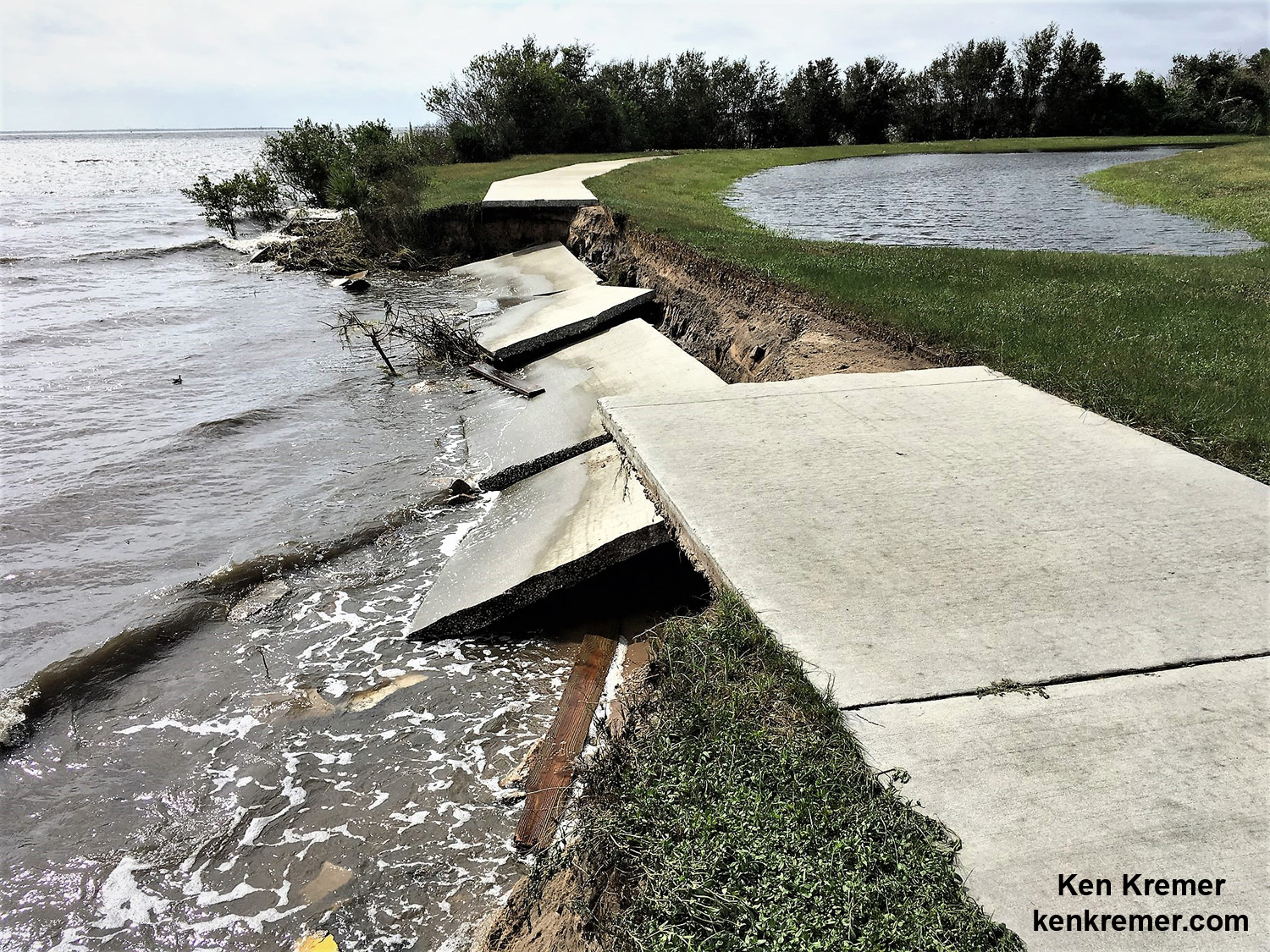
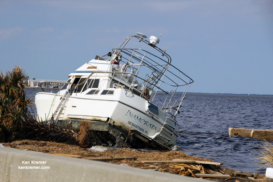
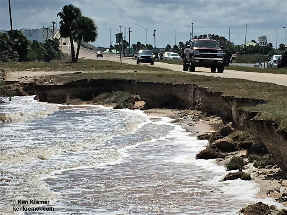
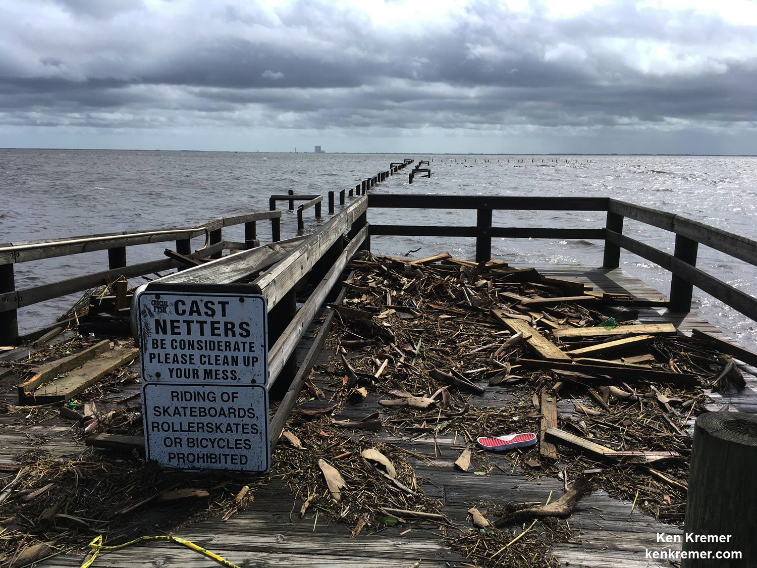
A number of popular public launch viewing locations were also severely damaged or destroyed as I witnessed personally driving in Titusville around just hours after Irma fled north.
See my photos from Rotary River Front Park, Space View Park and others along Rt. 1 in Titusville – which had offered unimpeded, spectacular and beautiful views across the Indian Rover lagoon to the KSC and Cape Canaveral launch pads.

Piers, docks, walkways, parking areas, piping and more were ripped up, smashed, sunken and devastated with piles of metal, bricks, wood, trees, bushes, trash and more scattered about in sad and unrecognizable heaps.
From a distance of several miles, the iconic VAB and the launch pads themselves did not seem to suffer obvious destruction – see my photos herein.
As of today over 500,000 customers across Florida remain without power, including tens of thousands in central Florida.
Numerous traffic lights in Titusville, Cape Canaveral, Cocoa Beach and Melbourne and other Brevard County and central Florida cities and communities are still not functioning today – creating all sorts of road traffic hazards!
Damage assessment teams from NASA, ULA, SpaceX, the USAF and contractors are now carefully scrutinizing every aspect of the Space Coast launch pads and facilities to ensure successful liftoffs whenever they resume in a few weeks.
Virtually all traffic lights were not operating and businesses and gas stations were closed in the hours before and after Irma pummeled communities across the space coast and central Florida. There were very long lines at the first gas stations that did reopen on Monday and Tuesday.

KSC was closed and evacuated of all personnel during the storm, except for only a small ‘Ride-out’ team of roughly 130 or so KSC personnel based inside the Emergency Operations Center (EOC) inside the Launch Control Center. They remained on site to monitor spaceport facilities.
“I want to take this opportunity to thank—and commend—the Ride-out and Damage Assessment and Recovery Teams for the outstanding job they did watching over the Center in our absence and getting it ready for our return in the aftermath of Hurricane Irma,” Cabana added. “I also want to thank all of you for the outstanding job that you did in getting the Center ready for the hurricane. As a result of your efforts, the Center was well prepared for the storm.”
The Damage Assessment and Recovery Teams explained that “the industrial and Launch Complex 39 areas have been inspected and are safe for personnel to return to work. This includes the KSC Child Development Center and all administrative work areas.”
“All facility systems including communication, power, and air conditioning are functional.”
Montieth confirmed damage to many buildings.
“In an initial assessment of the Cape facilities, about 40 % of buildings we inspected so far have received some damage. So 107 of 216 buildings at the Cape inspected have already been identified with damage.

“Lots of roof and siding damage, Montieth explained on Sept. 13. “We haven’t inspected the beaches yet.
“We have water issues at the Cape. We need water for the chillers to cool the operational buildings.”
Luckily the damage from Irma was less than feared.
“Under Hurricane Matthew there was about $50 million worth of damage between us and our launch partners. We think it will be less this time for Irma but we have a lot more work to do,” noted Montieth.
“The storm wasn’t as bad as expected. You hope for the best and prepare for the worst and that’s what we did. We had a ride-out team on base in a secure facility. Irma traveling over land helped us out. But we still got hit here by over 90 MPH winds gusts and over 58 mph winds – which are hurricane category 1 winds.”
“We also got hit by what we believe are 3 probable small tornadoes that hit the base. That claim is up to the NWS.”
He noted that the X-37B was launched successfully last Friday by SpaceX and that ongoing hurricane preparations and evacuations went to full swing right afterward the morning blastoff.
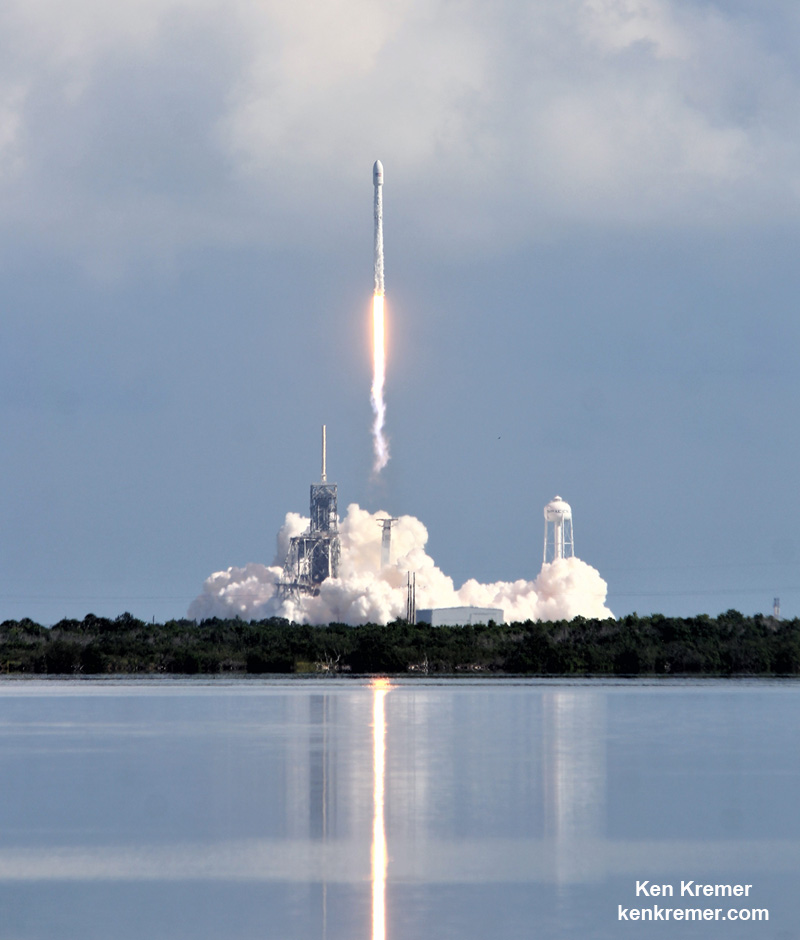
Watch for Ken’s continuing onsite X-37B OTV-5 and NASA mission reports direct from the Kennedy Space Center and Cape Canaveral Air Force Station, Florida.
Stay tuned here for Ken’s continuing Earth and Planetary science and human spaceflight news.
NASA, NOAA Satellites Track Hurricane Irma’s Path
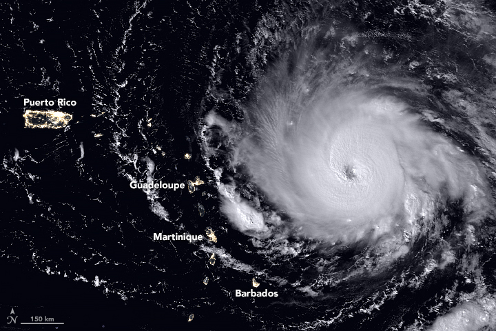
Record-setting Hurricane Irma barreled over the Caribbean islands of St. Martin, St. Barthelemy and Anguilla early Wednesday, destroying buildings with its sustained winds of 185 mph (297 kph), with rains and storm surges causing major flooding. The US National Hurricane Center listed the Category 5 Irma as the strongest Atlantic hurricane ever recorded north of the Caribbean and east of the Gulf of Mexico. The storm continues to roar on a path toward the U.S. and British Virgin Islands, Puerto Rico and possibly Florida, or along the southeast coast of the US.
This animation of NOAA’s GOES East satellite imagery from Sept. 3 at 8:15 a.m. EDT (1215 UTC) to Sept. 6 ending at 8:15 a.m. EDT (1215 UTC) shows Category 5 Hurricane Irma as it moved west and track over St. Martin by 8 a.m. EDT on Sept. 6:
Different models have Irma traveling on slightly different paths and officials from all the areas that might possibly be hit are telling people to prepare and follow evacuation orders. National Hurricane Center scientist Eric Blake said via twitter that some models had the storm going one way, and some another. But he cautioned everyone in a potential path should take precautions. “Model trends can be quite misleading- could just change right back. It is all probabilistic at this point. It could still miss [one particular area]. But chances of an extreme event is rising.”
Never seen a #hurricane this strong last so long in the Atlantic basin. #Irma is more like an unwelcome western Pacific supertyphoon ?? pic.twitter.com/55tFsbYWz1
— Eric Blake ? (@EricBlake12) September 6, 2017
The fleet of Earth-observing satellites are providing incredible views of this monster storm, and even astronauts on board the International Space Station are capturing views:
The International Space Station’s external cameras captured a dramatic view of Hurricane Irma as it moved across the Atlantic Ocean Sept. 5. pic.twitter.com/mc61pt2G8O
— Intl. Space Station (@Space_Station) September 5, 2017
#GOES16 captured this geocolor image of Hurricane #Irma approaching Anguilla at about 7:00 am (EDT). Latest info @ https://t.co/cSGOfrM0lG pic.twitter.com/R24P0Q1EPm
— NOAA Satellites (@NOAASatellites) September 6, 2017
GOES-16 view of #HurricaneIrma at 30-second intervals covering 5-hour period ending at 352 AM CDT (9/6), including its passage over Barbuda. pic.twitter.com/WL6l6klPKw
— NWS Twin Cities (@NWSTwinCities) September 6, 2017
The eye of a category 5 hurricane. #Irma #GOES16 pic.twitter.com/eATVZspJZx
— NASA SPoRT (@NASA_SPoRT) September 5, 2017
While satellite views provide the most comprehensive view of Irma’s potential track, there’s also a more ‘hands-on’ approach to getting data on hurricanes. NOAA hurricane hunter Nick Underwood posted this video while his plane flew into Hurricane Irma yesterday. The plane’s specialized instruments can take readings on the storm that forecasters can’t get anywhere else:
My day at the office. #HurricaneIrma @NOAA_HurrHunter pic.twitter.com/wpH83NIc6m
— Nick Underwood (@TheAstroNick) September 5, 2017
But Irma isn’t the only storm to keep an eye on. Tropical storms Katia and Jose are also on the horizon:
An overview of the active tropics: 24-hour animation of TS #Katia (left), Hurricane #Irma (center), and TS #Jose (right). #GOES16 pic.twitter.com/DiuhZP4f6y
— NASA SPoRT (@NASA_SPoRT) September 6, 2017
In the meantime, a launch is scheduled from Cape Canaveral on Thursday, September 7. SpaceX is hoping to launch the US Air Force’s X-37B reusable spaceplane, but current forecasts put only a 50% chance of weather suitable enough on Thursday, and only 40% on Friday. We’ll keep you posted.
For the latest satellite views, the Twitter accounts above are posting regular updates.
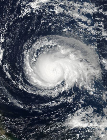
Credits: NOAA/NASA Goddard MODIS Rapid Response Team.
New Age in Weather Forecasting Begins with Spectacular 1st Images from NASA/NOAA GOES-16 Observatory
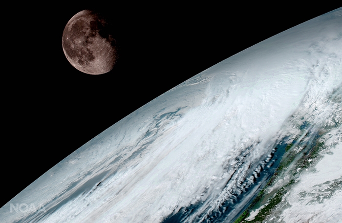

KENNEDY SPACE CENTER, FL – A new age has begun in the nations weather forecasting capabilities with the release today (Jan. 23) of the spectacular first images gathered by the recently launched NASA/NOAA GOES-16 observatory.
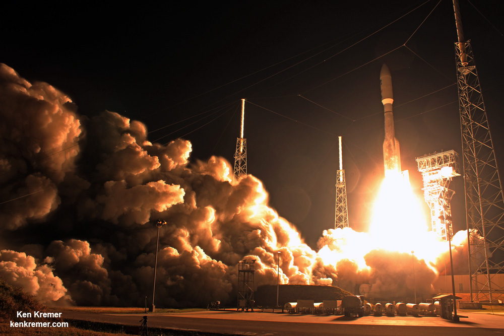
The highly advanced Geostationary Operational Environmental Satellite-16 (GOES-16) weather observatory lifted off two months ago atop a ULA Atlas V rocket on Nov. 19, 2016 from Space Launch Complex 41 (SLC-41) on Cape Canaveral Air Force Station, Florida.
GOES-16 (formerly known as GOES-R through the launch) is the first in a new series of revolutionary NASA/NOAA geostationary weather satellites that entails the first significant instrument upgrade to US weather forecasting capabilities in more than two decades.
“It will be like high-definition from the heavens,” says NOAA.
“Today’s release of the first images from #GOES16 signals the start of a new age in satellite weather observation!!!”
Thus the newly obtained and published imagery has been anxiously awaited by scientists, meteorologists and ordinary weather enthusiasts.
“This is such an exciting day for NOAA! One of our GOES-16 scientists compared this to seeing a newborn baby’s first pictures — it’s that exciting for us,” said Stephen Volz Ph.D. director of NOAA’s Satellite and Information Service, in a statement.
“These images come from the most sophisticated technology ever flown in space to predict severe weather on Earth. The fantastically rich images provide us with our first glimpse of the impact GOES-16 will have on developing life-saving forecasts.”
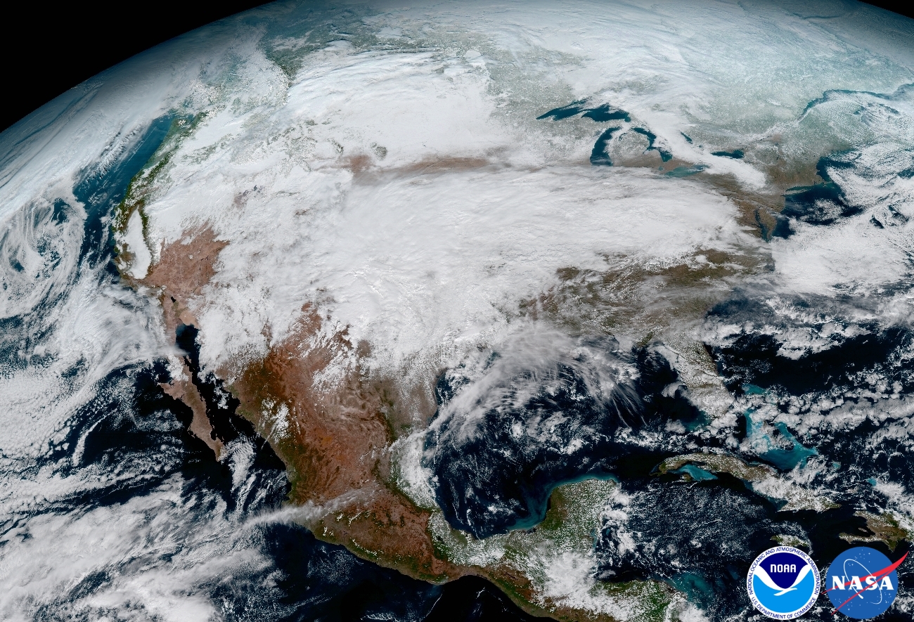
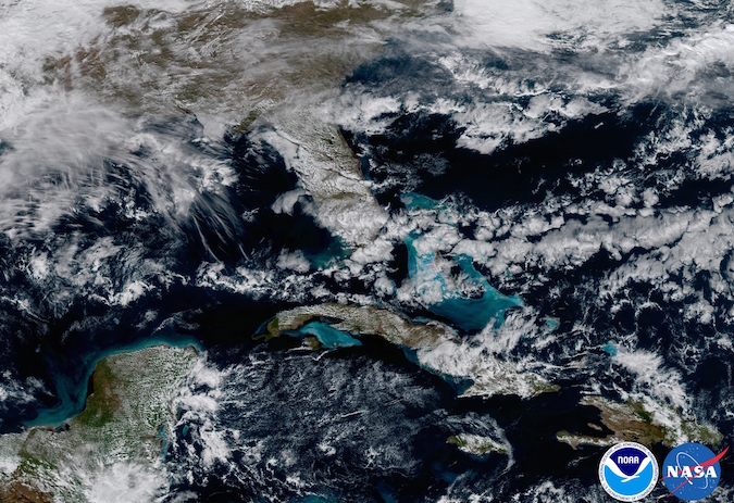
An especially eye-popping image taken by GOES -16 from its equatorial vantage point situated in geostationary orbit 22,300 miles (35,800 kilometers) above Earth and published today, shows both the Earth and the Moon together – as the lead image here.
The Earth/Moon combo shot is not only fantastically pleasing to the eye, but also serves a significant scientific purpose.
“Like earlier GOES satellites, GOES-16 will use the moon for calibration,” say NOAA officials.
“GOES-16 will boost the nation’s weather observation network and NOAA’s prediction capabilities, leading to more accurate and timely forecasts, watches and warnings.”
GOES-16 is the most advanced and powerful weather observatory ever built and will bring about a ‘quantum leap’ in weather forecasting.
“Seeing these first images from GOES-16 is a foundational moment for the team of scientists and engineers who worked to bring the satellite to launch and are now poised to explore new weather forecasting possibilities with this data and imagery,” said Volz.
“The incredibly sharp images are everything we hoped for based on our tests before launch. We look forward to exploiting these new images, along with our partners in the meteorology community, to make the most of this fantastic new satellite.”
It’s dramatic new imagery will show the weather in real time enabling critical life and property forecasting, help pinpoint evacuation zones and also save people’s lives in impacted areas of severe weather including hurricanes and tornadoes.
And the huge satellite can’t come online soon enough, as demonstrated by the severe winter weather and tornadoes that just wreaked havoc and death in various regions of the US.
Another breathtaking image product (seen below) produced by the GOES-16 Advanced Baseline Imager (ABI) instrument, built by Harris Corporation, shows a full-disc view of the Western Hemisphere in high detail — at four times the image resolution of existing GOES spacecraft.
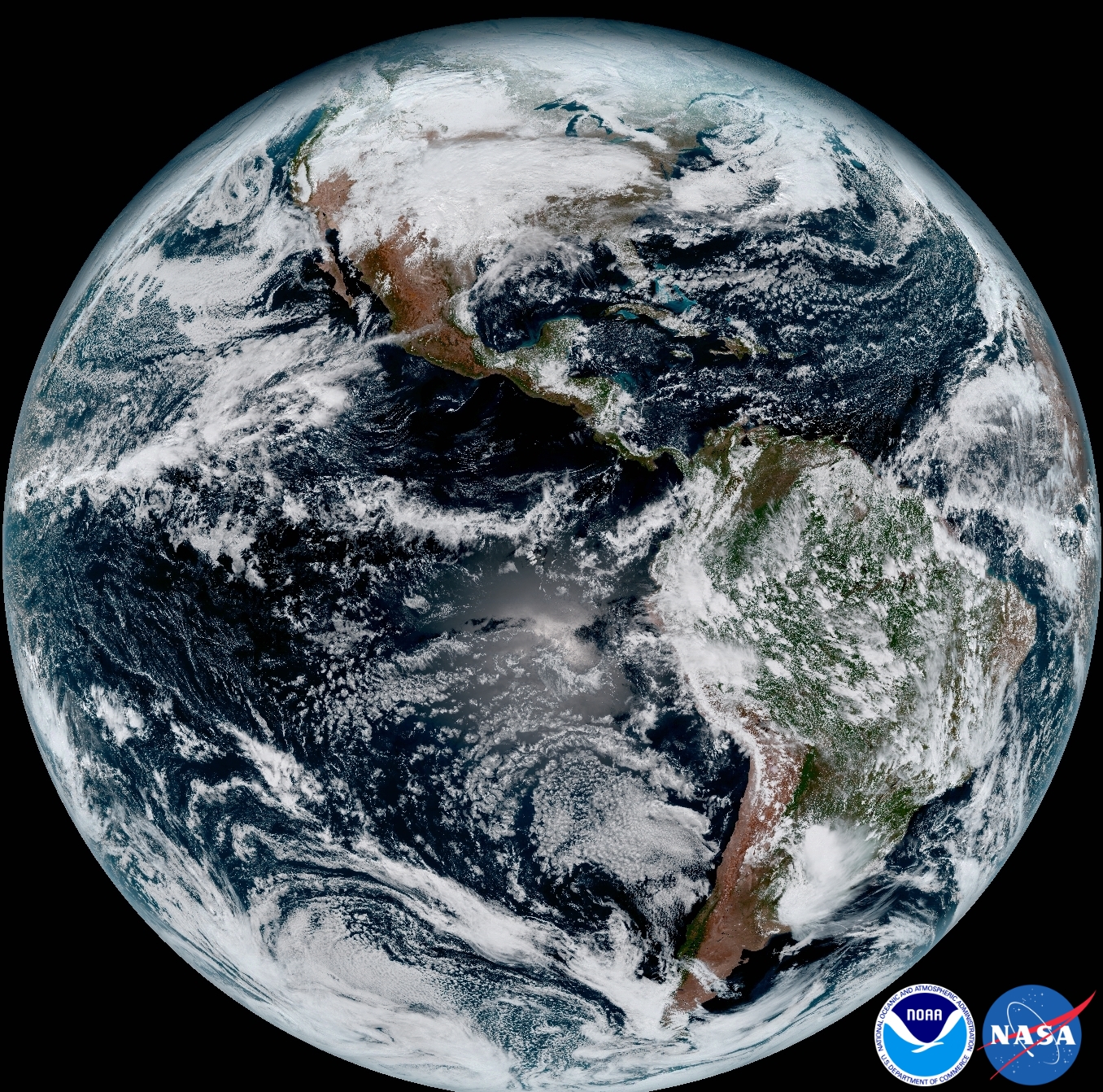
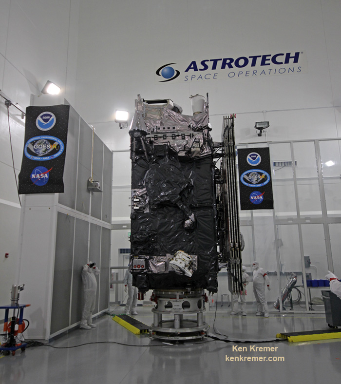
The 11,000 pound satellite was built by prime contractor Lockheed Martin and is the first of a quartet of four identical satellites – comprising GOES-R, S, T, and U – at an overall cost of about $11 Billion. This will keep the GOES satellite system operational through 2036.
This next generation of GOES satellites will replace the currently operating GOES East and GOES West satellites.
NOAA will soon decide whether GOES-16 will replace either the East or West satellites. A decision from NOAA is expected in May. GOES-16 will be operational by November 2017 as either the GOES-East or GOES-West satellite. Of course everyone wants it first.
The next satellite is nearing assembly completion and will undergo about a year of rigorous environmental and acoustic testing before launch. It will go to whichever slot was not selected this year.
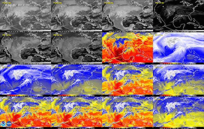
The six instrument science suite includes the Advanced Baseline Imager (ABI) built by Harris Corporation, the Geostationary Lightning Mapper (GLM) built by Lockheed Martin, Solar Ultraviolet Imager (SUVI), Extreme Ultraviolet and X-Ray Irradiance Sensors (EXIS), Space Environment In-Situ Suite (SEISS), and the Magnetometer (MAG).
ABI is the primary instrument and will collect 3 times more spectral data with 4 times greater resolution and scans 5 times faster than ever before – via the primary Advanced Baseline Imager (ABI) instrument – compared to the current GOES satellites.
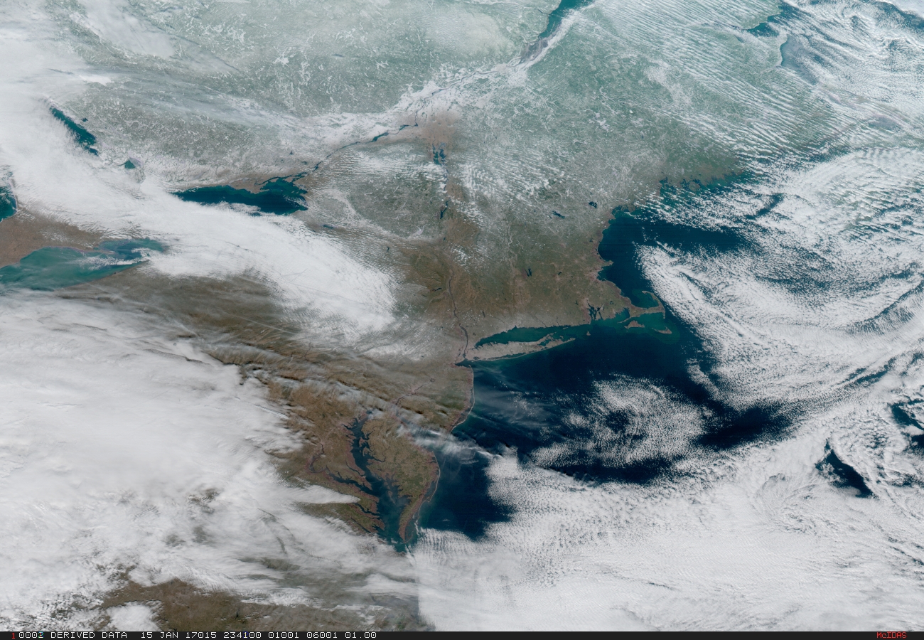
“The higher resolution will allow forecasters to pinpoint the location of severe weather with greater accuracy. GOES-16 can provide a full image of Earth every 15 minutes and one of the continental U.S. every five minutes, and scans the Earth at five times the speed of NOAA’s current GOES imagers.”
GOES-R launched on the massively powerful Atlas V 541 configuration vehicle, augmented by four solid rocket boosters on the first stage. As I witnessed and reported here.
Stay tuned here for Ken’s continuing Earth and Planetary science and human spaceflight news.
Ken Kremer
NASA’s Experimental Hurricane Monitoring Fleet Launched by Pegasus rocket
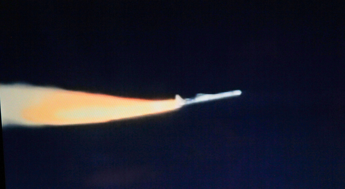

KENNEDY SPACE CENTER, FL – NASA’s constellation of experimental hurricane monitoring CYGNSS microsatellites was successfully air launched by the unique Orbital ATK winged Pegasus rocket on Thursday, Dec 15 – opening a new era in weather forecasters ability to measure the buildup of hurricane intensity in the tropics from orbit that will eventually help save lives and property from impending destructive storms here on Earth.
The agency’s innovative Cyclone Global Navigation Satellite System (CYGNSS) earth science mission was launched at 8:37 a.m. EST, Dec. 15, aboard a commercially developed Orbital ATK Pegasus XL rocket from a designated point over the Atlantic Ocean off the east coast of Florida.
Officials just announced this morning Dec. 16 that the entire fleet is operating well.
“NASA confirmed Friday morning that all eight spacecraft of its latest Earth science mission are in good shape.”
“The launch of CYGNSS is a first for NASA and for the scientific community,” said Thomas Zurbuchen, associate administrator for the agency’s Science Mission Directorate in Washington.
“As the first orbital mission in our Earth Venture program, CYGNSS will make unprecedented measurements in the most violent, dynamic, and important portions of tropical storms and hurricanes.”
Late Thursday, NASA announced that contact had been made with the entire fleet of eight small satellites after they had been successfully deployed and safely delivered to their intended position in low Earth orbit.
“We have successfully contacted each of the 8 observatories on our first attempt,” announced Chris Ruf, CYGNSS principal investigator with the Department of Climate and Space Sciences and Engineering at the University of Michigan.
“This bodes very well for their health and “status, which is the next thing we will be carefully checking with the next contacts in the coming days.”
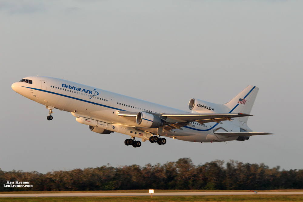
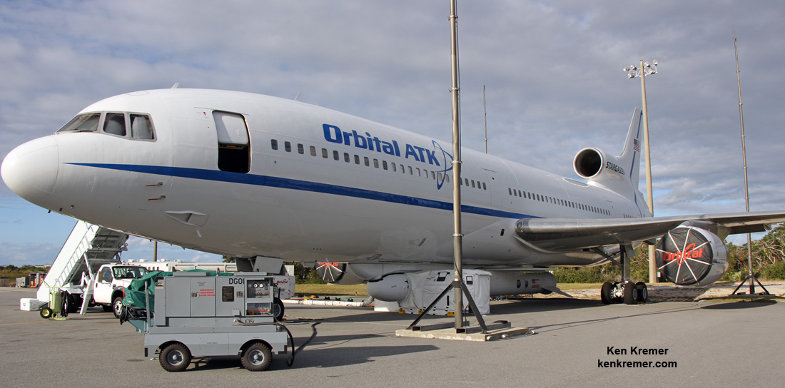
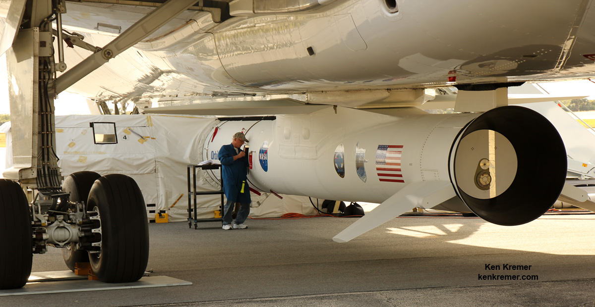
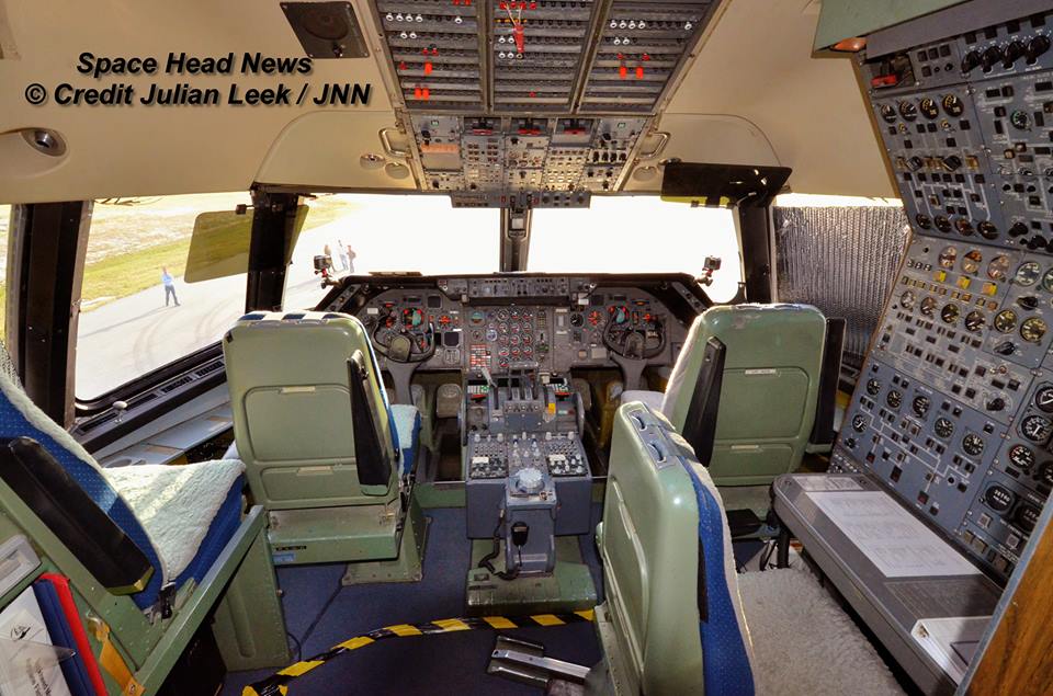
The three stage Pegasus XL rocket housing the CYGNSS earth science payload inside the payload fairing had been carried aloft to 39,000 feet by an Orbital ATK L-1011 Tristar and dropped from the aircrafts belly for an air launch over the Atlantic Ocean and about 110 nautical miles east-northeast of Daytona Beach.
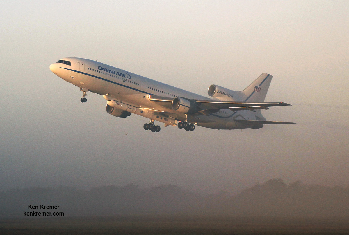
The L-1011 nicknamed Stargazer took off at about 7:30 a.m. EST from NASA’s Skid Strip on Cape Canaveral Air Force Station in Florida as the media including myself watched the events unfold under near perfect Sunshine State weather with brilliantly clear blue skies.
After flying to the dropbox point – measuring about 40-miles by 10-miles (64-kilometers by 16-kilometers) – the Pegasus rocket was dropped from the belly, on command by the pilot, for a short freefall of about 5 seconds to initiate the launch sequence and engine ignition.
Pegasus launches horizontally in midair with ignition of the first stage engine burn, and then tilts up to space to begin the approximate ten minute trek to LEO.
The rocket launch and satellite release when exactly as planned with no hiccups.
It’s a beautiful day, with gorgeous weather,” said NASA CYGNSS launch director Tim Dunn. “We had a nominal flyout, and all three stages performed beautifully. We had no issues at all with launch vehicle performance.”
Deployment of the first pair of CYGNSS satellites in the eight satellite fleet started just 13 minutes after launch. The other six followed sequentially staged some 30 seconds apart.
“It’s a great event when you have a successful spacecraft separation – and with eight microsatellites, you get to multiply that times eight,” Dunn added.
“The deployments looked great — right on time,” said John Scherrer, CYGNSS Project Manager at the Southwest Research Institute and today’s CYGNSS mission manager, soon after launch.
“We think everything looks really, really good. About three hours after launch we’ll attempt first contact, and after that, we’ll go through a series of four contacts where we hit two [observatories] each time, checking the health and status of each spacecraft,” Scherrer added several prior to contact..
CYGNSS small satellite constellation launch came after a few days postponement due to technical issues following an aborted attempt on Monday, when the release mechanism failed and satellite parameter issues cropped up on Tuesday, both of which were rectified.
NASA’s innovative Cyclone Global Navigation Satellite System (CYGNSS) mission is expected to revolutionize hurricane forecasting by measuring the intensity buildup for the first time.
“The CYGNSS constellation consists of eight microsatellite observatories that will measure surface winds in and near a hurricane’s inner core, including regions beneath the eyewall and intense inner rainbands that previously could not be measured from space,” according to a NASA factsheet.
CYGNSS is an experimental mission to demonstrate proof-of-concept that could eventually turn operational in a future follow-up mission if the resulting data returns turn out as well as the researchers hope.
The CYGNSS constellation of 8 identical satellites works in coordination with the Global Positioning System (GPS) satellite constellation.
The eight satellite CYGNSS fleet “will team up with the Global Positioning System (GPS) constellation to measure wind speeds over Earth’s oceans and air-sea interactions, information expected to help scientists better understand tropical cyclones, ultimately leading to improved hurricane intensity forecasts.”
They will receive direct and reflected signals from GPS satellites.
“The direct signals pinpoint CYGNSS observatory positions, while the reflected signals respond to ocean surface roughness, from which wind speed is retrieved.”
This schematic outlines the key launch events:
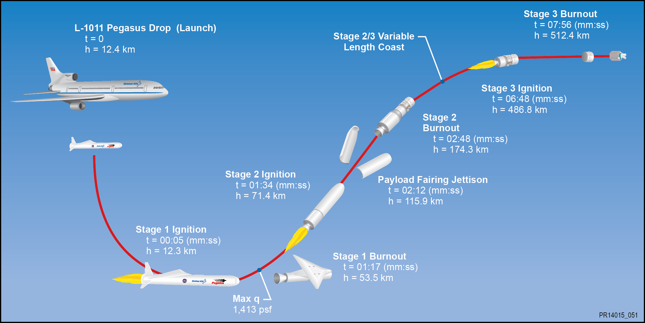
The $157 million fleet of eight identical spacecraft comprising the Cyclone Global Navigation Satellite System (CYGNSS) system were all delivered to low Earth orbit by the Orbital ATK Pegasus XL rocket.
The nominal mission lifetime for CYGNSS is two years but the team says they could potentially last as long as five years or more if the spacecraft continue functioning.
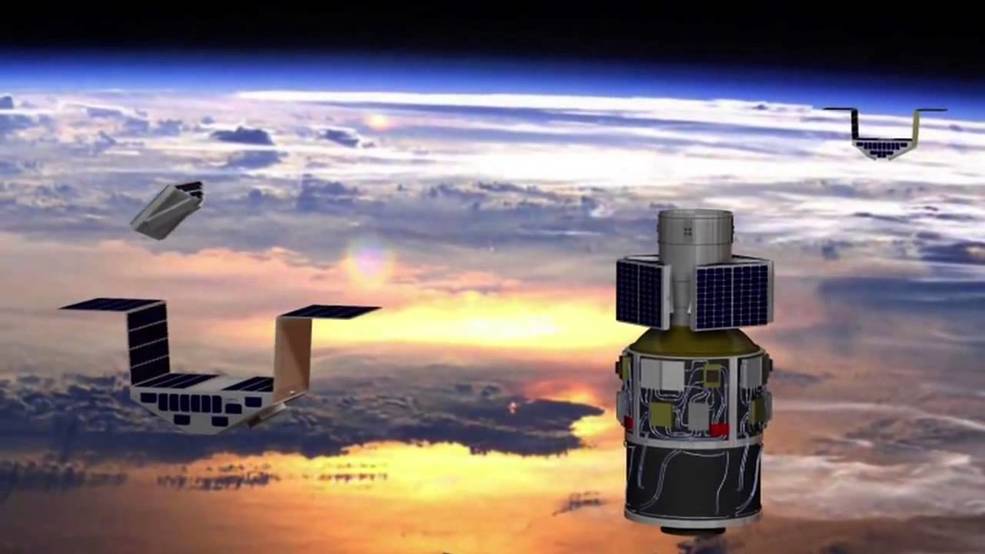
Pegasus launches from the Florida Space Coast are infrequent. The last once took place over 13 years ago in late April 2003 for the GALEX mission.
Typically they take place from Vandenberg Air Force Base in California or the Reagan Test Range on the Kwajalein Atoll.
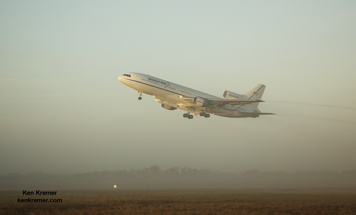
CYGNSS counts as the 20th Pegasus mission for NASA and the 43rd mission overall for Orbital ATK.
The CYGNSS spacecraft were built by Southwest Research Institute in San Antonio, Texas.
The solar panels and spacecraft dispenser were built by Sierra Nevada Corporation (SNC).
Each one weighs approx 29 kg. The deployed solar panels measure 1.65 meters in length.
The solar panels measure 5 feet in length and will be deployed within about 15 minutes of launch.
“We are thrilled to be a part of a project that helps gain better hurricane data that can eventually help keep a lot of people safe, but from a business side, we are also glad we could help SwRI achieve their mission requirements with better performance and lower cost and risk,” said Bryan Helgesen, director of strategy and business development for Space Technologies in SNC’s Space Systems business area, in a statement.
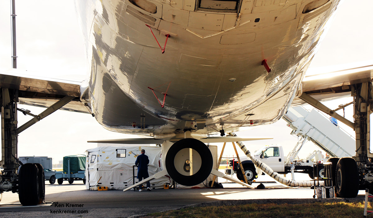
The Space Physics Research Laboratory at the University of Michigan College of Engineering in Ann Arbor leads overall mission execution in partnership with the Southwest Research Institute in San Antonio, Texas.
The Climate and Space Sciences and Engineering Department at the University of Michigan leads the science investigation, and the Earth Science Division of NASA’s Science Mission Directorate oversees the mission.
Stay tuned here for Ken’s continuing Earth and Planetary science and human spaceflight news.

………….
Learn more about ULA Atlas V EchoStar 19 comsat launch, GOES-R launch, Heroes and Legends at KSCVC, OSIRIS-REx, InSight Mars lander, ULA, SpaceX and Orbital ATK missions, Juno at Jupiter, SpaceX AMOS-6 & CRS-9 rocket launch, ISS, ULA Atlas and Delta rockets, Orbital ATK Cygnus, Boeing, Space Taxis, Mars rovers, Orion, SLS, Antares, NASA missions and more at Ken’s upcoming outreach events:
Dec. 16-18: “ULA Atlas V EchoStar 19 comsat launch,GOES-R weather satellite launch, OSIRIS-Rex, SpaceX and Orbital ATK missions to the ISS, Juno at Jupiter, ULA Delta 4 Heavy spy satellite, SLS, Orion, Commercial crew, Curiosity explores Mars, Pluto and more,” Kennedy Space Center Quality Inn, Titusville, FL, evenings
Hydraulic Pump Glitch Aborts NASA’s Hurricane MicroSat Fleet Launch to Dec. 15 – Live Coverage


KENNEDY SPACE CENTER, FL – Monday’s (Dec. 12) planned launch of NASA’s innovative Cyclone Global Navigation Satellite System (CYGNSS) hurricane microsatellite fleet was aborted when a pump in the hydraulic system that releases the Pegasus air-launch booster from its L-1011 carrier aircraft failed in flight. UPDATE: launch delayed to Dec 15, story revised
NASA and Orbital ATK confirmed this afternoon that the launch of the Orbital ATK commercial Pegasus-XL rocket carrying the CYGNSS small satellite constellation has been rescheduled again to Thursday, Dec. 15 at 8:26 a.m. EST from a drop point over the Atlantic Ocean.
Late last night the launch was postponed another day from Dec. 14 to Dec. 15 to solve a flight parameter issue on the CYGNSS spacecraft. New software was uploaded to the spacecraft that corrected the issue, NASA officials said.
“NASA’s launch of CYGNSS spacecraft is targeted for Thursday, Dec. 15,” NASA announced.
“We are go for launch of our #Pegasus rocket carrying #CYGNSS tomorrow, December 15 from Cape Canaveral Air Force Station,” Orbital ATK announced.
“The CYGNSS constellation consists of eight microsatellite observatories that will measure surface winds in and near a hurricane’s inner core, including regions beneath the eyewall and intense inner rainbands that previously could not be measured from space,” according to a NASA factsheet.
Despite valiant efforts by the flight crew to restore the hydraulic pump release system to operation as the L-1011 flew aloft near the Pegasus drop zone, they were unsuccessful before the launch window ended and the mission had to be scrubbed for the day by NASA Launch Director Tim Dunn.
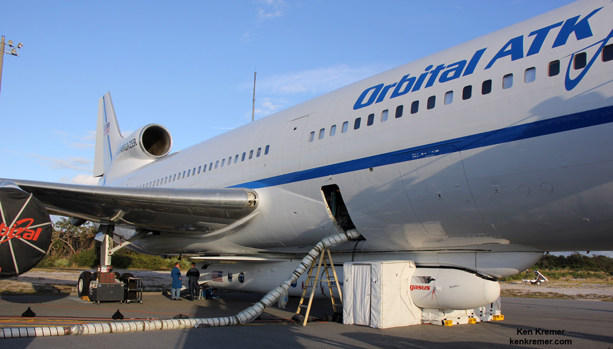
The Pegasus/CYGNSS vehicle is attached to the bottom of the Orbital ATK L-1011 Stargazer carrier aircraft.

The hydraulic release system passed its pre-flight checks before takeoff of the Stargazer.
“Launch of the Pegasus rocket was aborted due to an issue with the launch vehicle release on the L-1011 Stargazer. The hydraulic release system operates the mechanism that releases the Pegasus rocket from the carrier aircraft. The hydraulic system functioned properly during the pre-flight checks of the airplane,” said NASA.
A replacement hydraulic pump system component was flown in from Mojave, California, and successfully installed and checked out. Required crew rest requirements were also met.
The one-hour launch window opens at 8:20 a.m and the actual deployment of the rocket from the L-1011 Tristar is timed to occur 5 minutes into the window at 8:26 a.m.
NASA’s Pegasus/CYGNUS launch coverage and commentary will be carried live on NASA TV – beginning at 7 a.m. EDT
You can watch the launch live on NASA TV at – http://www.nasa.gov/nasatv
Live countdown coverage on NASA’s Launch Blog begins at 6:30 a.m. Dec. 15.
Coverage will include live updates as countdown milestones occur, as well as video clips highlighting launch preparations and the flight.
A prelaunch program by NASA EDGE will begin at 6 a.m.
NASA’s Kennedy Space Center is also providing live coverage on social media at:
http://www.twitter.com/NASAKennedy
https://www.facebook.com/NASAKennedy
Orbital ATK is also providing launch and mission update at:
twitter.com/OrbitalATK
The weather forecast from the Air Force’s 45th Weather Squadron at Cape Canaveral has significantly increased to predicting a 90% chance of favorable conditions on Thursday, Dec. 15.
The primary weather concerns are for flight cumulus clouds.
The Pegasus rocket cannot fly through rain or clouds due to a negative impact and possible damage on the rocket’s thermal protection system (TPS).
In the event of a delay, the range is also reserved for Friday, Dec. 16 where the daily outlook remains at a 90% chance of favorable weather conditions.

After Stargazer takes off from the Skid Strip early Thursday around 6:30 a.m. EST, it will fly north to a designated drop point box about 126 miles east of Daytona Beach, Florida over the Atlantic Ocean. The crew can search for a favorable launch point if needed, just as they did Monday morning.
The drop box point measures about 40-miles by 10-miles (64-kilometers by 16-kilometers). The flight crew flew through the drop box twice on Monday, about a half an hour apart, as they tried to repair the hydraulic system by repeatedly cycling it on and off and sending commands.
“It was not meeting the prescribed launch release pressures, indicating a problem with the hydraulic pump,” said NASA CYGNSS launch director Tim Dunn.
“Fortunately, we had a little bit of launch window to work with, so we did a lot of valiant troubleshooting in the air. As you can imagine, everyone wanted to preserve every opportunity to have another launch attempt today, so we did circle around the race once, resetting breakers on-board the aircraft, doing what we could in flight to try to get that system back into function again.”
The rocket will be dropped for a short freefall of about 5 seconds to initiate the launch sewuence. It launches horizontally in midair with ignition of the first stage engine burn, and then tilts up to space to begin the trek to LEO.
Here’s a schematic of key launch events:

The $157 million fleet of eight identical spacecraft comprising the Cyclone Global Navigation Satellite System (CYGNSS) system will be delivered to low Earth orbit by the Orbital ATK Pegasus XL rocket.
The nominal mission lifetime for CYGNSS is two years but the team says they could potentially last as long as five years or more if the spacecraft continue functioning.

Pegasus launches from the Florida Space Coast are infrequent. The last once took place over 13 years ago in April 2003 for the GALEX mission.
Typically they take place from Vandenberg Air Force Base in California or the Reagan Test Range on the Kwajalein Atoll.
CYGNSS counts as the 20th Pegasus mission for NASA.
The CYGNSS spacecraft were built by Southwest Research Institute in San Antonio, Texas. Each one weighs approx 29 kg. The deployed solar panels measure 1.65 meters in length.
The solar panels measure 5 feet in length and will be deployed within about 15 minutes of launch.

The Space Physics Research Laboratory at the University of Michigan College of Engineering in Ann Arbor leads overall mission execution in partnership with the Southwest Research Institute in San Antonio, Texas.
The Climate and Space Sciences and Engineering Department at the University of Michigan leads the science investigation, and the Earth Science Division of NASA’s Science Mission Directorate oversees the mission.
Stay tuned here for Ken’s continuing Earth and Planetary science and human spaceflight news.
CYGNSS Constellation of Hurricane Monitoring MicroSats Set for Dec. 12 Launch – Watch Live


KENNEDY SPACE CENTER, FL – An exciting new chapter in hurricane monitoring and forecasting intensity prediction is due to open Monday morning at NASA’s Kennedy Space Center when a new constellation of microsatellites dubbed CYGNSS are slated to be deployed from an air-launched Orbital ATK Pegasus XL rocket.
The fleet of eight identical spacecraft comprising the Cyclone Global Navigation Satellite System (CYGNSS) system will be delivered to Earth orbit by an Orbital ATK Pegasus XL rocket.
The Pegasus/CYGNSS vehicle is attached to the bottom of the Orbital ATK L-1011 Stargazer carrier aircraft.
“The CYGNSS constellation consists of eight microsatellite observatories that will measure surface winds in and near a hurricane’s inner core, including regions beneath the eyewall and intense inner rainbands that previously could not be measured from space,” according to a NASA factsheet.
The data obtained by studying the inner core of tropical cyclones “will help scientists and meteorologists better understand and predict the path of a hurricane.”
Improved hurricane forecasts can help protect lives and mitigate property damage in coastal areas under threat from hurricanes and cyclones.

CYGNSS is an experimental mission to demonstrate proof-of-concept that could eventually turn operational in a future follow-up mission if the resulting data returns turn out as well as the researchers hope.
The Pegasus XL rocket with the eight observatories are tucked inside the nose cone will be air-launched by dropping them from the belly of Orbital’s modified L-1011 carrier aircraft, nicknamed Stargazer, after taking off from the “Skid Strip” runway at Cape Canaveral Air Force Station in Florida.
If all goes well, the rocket will be dropped from Stargazer’s belly for the launch currently planned for Monday, Dec. 12 at 8:24 a.m. EST.
Five seconds after the rocket is deployed at 39,000 feet, the solid fueled Pegasus XL first stage engine with ignite for the trip to low earth orbit.
They will be deployed from a dispenser at an altitude of about 510 km and an inclination of 35 degrees above the equator.

The launch window lasts 1 hour with the actual deployment timed to occur 5 minutes into the window.
NASA’s Pegasus/CYGNUS launch coverage and commentary will be carried live on NASA TV – beginning at 6:45 a.m. EDT
You can watch the launch live on NASA TV at – http://www.nasa.gov/nasatv
Live countdown coverage on NASA’s Launch Blog begins at 6:30 a.m. Dec. 12.
The weather forecast from the Air Force’s 45th Weather Squadron at Cape Canaveral is currently predicting a 40% chance of favorable conditions on Monday Dec 12.
The primary weather concerns are for flight through precipitation and cumulus clouds.
The Pegasus rocket cannot fly through rain or clouds due to a negative impact on the thermal protection system.
In the event of a delay, the range is also reserved for Tuesday, Dec. 13 where the daily outlook increases significantly to an 80% chance of favorable weather conditions.
After Stargazer takes off from the Skid Strip early Monday morning around 6:30 a.m. EST, it will fly north to a designated point about 126 miles east of Daytona Beach, Florida over the Atlantic Ocean. The crew can search for a favorable launch point if needed.
The rocket will be dropped for a short freefall of about 5 seconds. It launches horizontally in midair with ignition of the first stage engine burn, and then tilts up to space to begin the trek to LEO.
The $157 million CYGNSS constellation works in coordination with the Global Positioning System (GPS) satellite constellation.
The eight satellite CYGNSS fleet “will team up with the Global Positioning System (GPS) constellation to measure wind speeds over Earth’s oceans and air-sea interactions, information expected to help scientists better understand tropical cyclones, ultimately leading to improved hurricane intensity forecasts.”
They will receive direct and reflected signals from GPS satellites.
“The direct signals pinpoint CYGNSS observatory positions, while the reflected signals respond to ocean surface roughness, from which wind speed is retrieved.”
“Forecasting capabilities are going to be greatly increased,” NASA Launch Manager Tim Dunn said at the prelaunch media briefing at the Kennedy Space Center on Dec. 10. “As a Floridian, I will really appreciate that, certainly based on what we had to do this fall with Hurricane Matthew.”
Indeed the CYGNSS launch was delayed by Hurricane Matthew, just like the NASA/NOAA GOES-R launch was also delayed from early to mid-November by the deadly Cat 4 storm.
The nominal mission lifetime for CYGNSS is two years but the team says they could potentially last as long as five years or more if the spacecraft continue functioning.
Pegasus launches from the Florida Space Coast are infrequent. The last once took place over 13 years ago.
Typically they take place from Vandenberg Air Force Base in California or the Reagan Test Range on the Kwajalein Atoll.
CYGNSS counts as the 20th Pegasus mission for NASA.
The CYGNSS spacecraft were built by Southwest Research Institute in San Antonio, Texas. Each one weighs approx 29 kg. The deployed solar panels measure 1.65 meters in length.
The Space Physics Research Laboratory at the University of Michigan College of Engineering in Ann Arbor leads overall mission execution in partnership with the Southwest Research Institute in San Antonio, Texas.
The Climate and Space Sciences and Engineering Department at the University of Michigan leads the science investigation, and the Earth Science Division of NASA’s Science Mission Directorate oversees the mission.
Stay tuned here for Ken’s continuing Earth and Planetary science and human spaceflight news.


