Russian Crowdfunded Satellite May Soon Become Brightest “Star” in the Sky

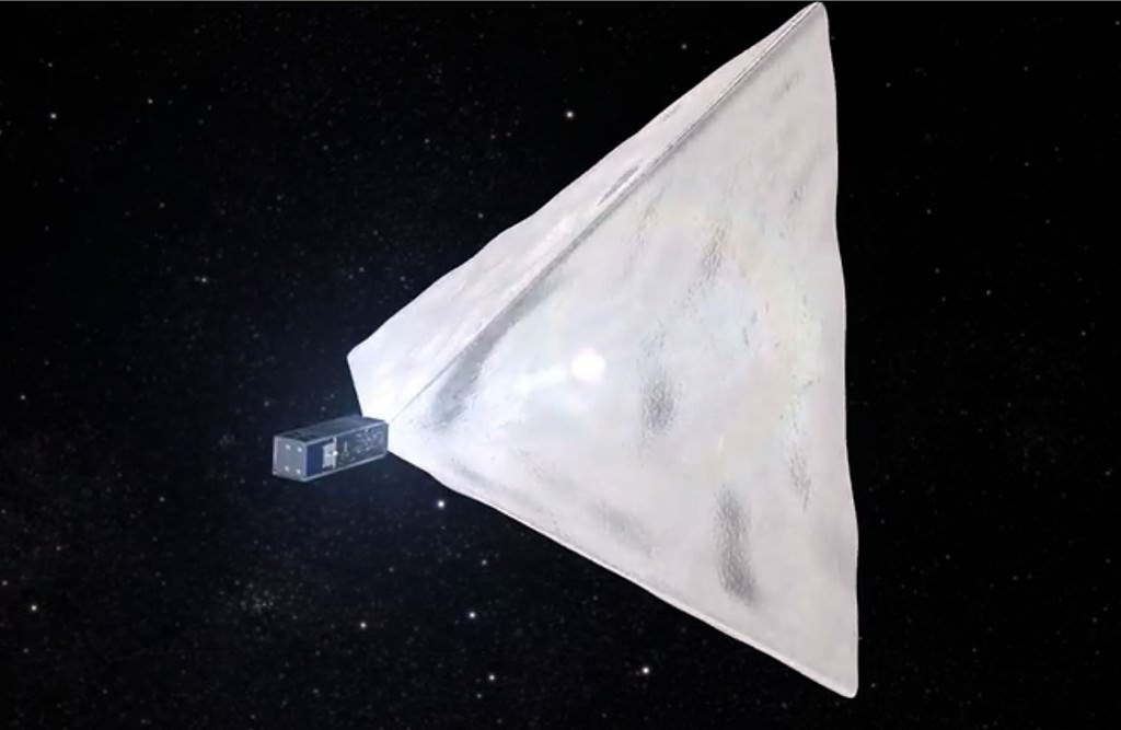
Illustration of the “Beacon” inflating from its canister after reaching orbit. The Mayak Project used the Russian version of Kickstarter called Boomstarter to fund the project. Credit: cosmomayak.ru / Mayak Project
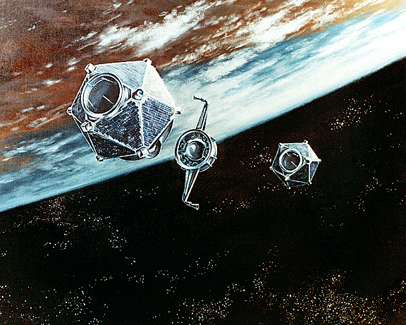
Artist’s view of the proposed Mayak (Beacon) satellite fully unfurled and orbiting Earth. Credit: cosmomayak.ru / Mayak Project

We may soon look up and see a satellite brighter than the space station and even Venus gliding across the night sky if a Russian crowdfunding effort succeeds. An enthusiastic team of students from Moscow University of Mechanical Engineering are using Boomstarter, the Russian equivalent of Kickstarter, to raise the money needed to build and launch a pyramid-shaped satellite made of highly reflective material they’re calling Mayak, Russian for “Beacon”.


Young engineers at Moscow University explain the Mayak Project

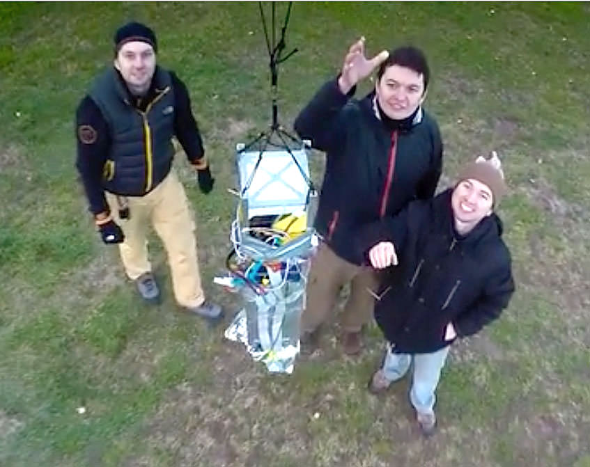
To date they’ve collected more than $23,000 or 1.7 million rubles. Judging from the video, the team has built the canister that would hold the satellite (folded up inside) and performed a high-altitude test using a balloon. If funding is secured, Beacon is scheduled to launch on a Soyuz-2 rocket from the Baikonur Cosmodrome in the second quarter of this year.

Illustration of the “Beacon” unfurling from its canister when it reaches orbit. The Mayak Project used the Russian version of Kickstarter called Boomstarter to fund the project. Credit: cosmomayak.ru / Mayak Project
Illustration of the “Beacon” inflating from its canister after reaching orbit. The Mayak Project used the Russian version of Kickstarter called Boomstarter to fund the project. Credit: cosmomayak.ru / Mayak Project

Once in orbit, Beacon will inflate into a pyramid with a surface area of 172 square feet (16 square meters). Made of reflective metallized film 20 times thinner than a human hair, the satellite is expected to become the brightest man-made object in orbit ever. That title is currently held by the International Space Station which can shine as brightly as magnitude -3 or about three times fainter than Venus. The brightest satellites, the Iridiums, can flare to magnitude -8 (as bright as the crescent moon) but only for a few seconds before fading back to invisibility. They form a “constellation” of  some 66 satellites that provide data and voice communications.

A student at the Mayak Lab in Moscow describes the container used to hold the reflective "Beacon" satellite. Credit:
A student at the Mayak Lab in Moscow describes the container used to hold the reflective “Beacon” satellite. Credit: cosmomayak.ru / Mayak Project

A concurrently-developed mobile app would allow users to know when Beacon would pass over a particular location. The students hope to achieve more than just track a bright, moving light across the sky. According to their website, the goal of the project is the “popularization of astronautics and space research in Russia, as well as improving the attractiveness of science and technology education among young people.” They want to show that almost anyone can build and send a spacecraft into orbit, not just corporations and governments.

Further, the students hope to test aerodynamic braking in the atmosphere and find out more about the density of air at orbital altitudes. Interested donors can give anywhere from 300 rubles (about $5) up 300,000 ($4,000). The more money, the more access you’ll have to the group and news of the satellite’s progress; the top donor will get invited to watch the launch on-site.

Moscow University students release the satellite on a test run. Credit: cosmomayak.ru / Mayak Project
Liftoff! Moscow University students release the satellite on a test run. Credit: cosmomayak.ru / Mayak Project

Once finished with the Mayak Project, the team wants to built another version that uses that atmosphere for braking its speed and returning it — and future satellites — safely back to Earth without the need for retro-rockets.

I think all these goals are worthy, and I admire the students’ enthusiasm. I only hope that satellite launching doesn’t become so cheap and popular that we end up lighting up the night sky even further. What do you think?

Spotting Asterix: France Marks 50 Years of Space Exploration

Image credit:

Author’s note: In the wake of the November 13th terrorist attacks, the French Space Agency CNES canceled the celebration of the 50th anniversary of the launch of Asterix. This post commemorates the launch of France’s first satellite 50 years ago this week, and pays a small tribute to the noblest of human endeavors, namely the exploration of space and the pioneering spirit of humanity exemplified by a heroic nation.

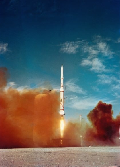
A milestone in space flight occurred 50 years ago tomorrow, when France became the sixth nation—behind the U.S.S.R., the United States, Canada, the United Kingdom and Italy—to field a satellite. The A1 mission, renamed Asterix after a popular cartoon character, launched from a remote desert base in Algeria a few hours after dawn at 9:52 UT on November 26th.

Though France was 6th nation in space, it was 3rd—following the Soviet Union and the United States—to launch a satellite atop its very own rocket: the three stage Diamant-A.

P12108
The launch of Asterix into the blue desert skies over Algeria.

The satellite launch was intended mainly to test the ability of the French-built rocket, which flew 11 more times before its retirement in 1975. Asterix did carry a signal transmitter, and was due to carry out ionospheric measurements during its short battery-powered life span. With a high elliptical orbit, Asterix won’t reenter the Earth’s atmosphere for several centuries to come.

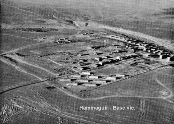
The launch occurred from the remote desert air base of Hammaguir, located 31 degrees north of the equator in western Algeria. Then as today, the site is a forlorn and austere location with very few creature comforts, though we can personally attest from our deployment to a similar French Air Base in Djibouti that the French military does serve wine in their mess hall…

Image credit
The tense control room during the launch of Asterix.

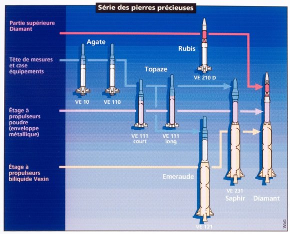
The French space program started in 1961 under president Charles de Gaulle and centered around the construction and use of the Diamant rocket. Three variants were built, including the one used to place Asterix in orbit. One of the stranger tales of the early space age involved the first—and thus far only—sub-orbital launch of a cat into space from the same Algerian site in 1963, though Iran recently made a vague statement that it would do the same in 2013.

Image credit
An aerial shot of Hammaguir Air Base in Algeria from the early 1960s.

Contact with Asterix was lost due to a damaged satellite antenna shortly after launch. Founded in 1961, the French space agency CNES (The Centre National d’Etudes Spatiales, or National Centre for Space Studies) now partners with NASA and the European Space Agency on missions including micro-gravity studies on the International Space Station, Rosetta’s historic exploration of comet 67P Churyumov-Gerasimenko and more. And although the Hammaguir space facility in Algeria is no longer in use, CNES operates out of the Kourou Space Center in French Guiana and the Toulouse Space Center in southern France today.

A stamp series
A stamp series commemorating the Diamant rocket and Asterix.

Tracking Asterix

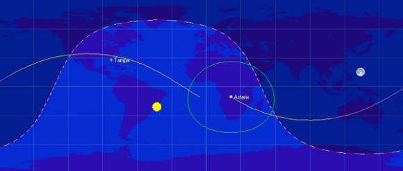
Though inoperative, Asterix still orbits the Earth once every 107 minutes in an elliptical low Earth orbit. Asterix ranges from a perigee of 523 kilometers to an apogee of 1,697 kilometers. In an orbit inclined 34 degrees relative to the Earth’s equator, Asterix isn’t expected to reenter for several centuries.

Image credit
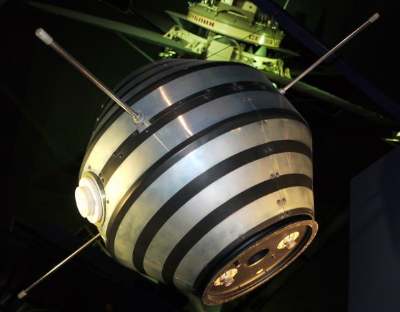
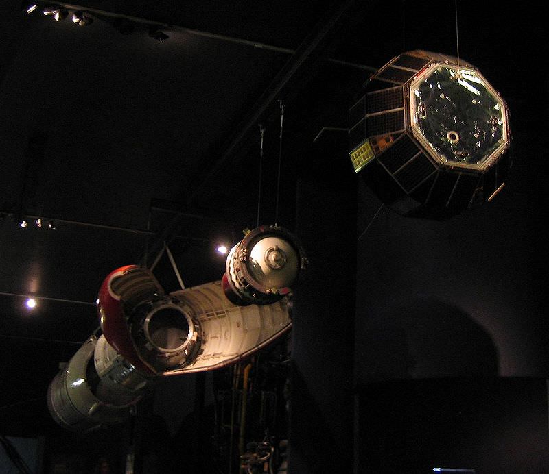
A replica of Asterix hanging in the Paris Air and Space Museum. Image credit: Pine/Wikimedia Commons

A 42 kilogram satellite approximately a meter across, Asterix is visible worldwide from about 40 degrees north to 40 degrees south latitude. Essentially a binocular object, you can nonetheless see Asterix from your backyard if you know exactly where and when to look for it in the sky. Asterix will appear brightest on a perigee pass directly overhead.

Asterix’s NORAD ID satellite catalog number is 01778/COSPAR ID 1965-096A.

The orbital trace of Asterix. Image credit: Orbitron

When it comes to hunting for binocular satellites, you need to now exactly where it’ll be in the sky at what time. We use Heavens-Above to discern exactly when a given satellite will pass a bright star, then simply watch at the appointed time with binoculars. We also run WWV radio in the background for a precise audio time hack. This allows us to keep our eyes continuously on the sky. This simple method is similar to that used by Project Moonwatch volunteers to track and record satellites starting in the late 1950s.

Image credit
The evolution of the Diamant rocket.

Other satellite challenges from the early Space Age include Alouette-1 (Canada’s first satellite), Prospero (UK’s first and only indigenous satellite) and the oldest of them all, the first three Vanguard satellites launched by the United States.

Don’t miss a chance to see this living relic of the early space age, still in orbit. Happy 50th to the CNES space agency: may your spirit of space exploration continue to soar and inspire us all.

Asteroid? Rocket Stage? Whatever it is, WT1190F Plunges to Earth Tonight

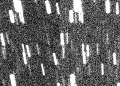
a short animation (spanning about 10 minutes) made out of my follow-up images. The first frame was obtained at 08:17UT while the second frame was obtained at 08:27UT of Nov, 12, 2015. (WT1190F is the star-like object at the centre while stars are trailed because the images were stacked on WT1190F motion). Credit: Ernesto Guido

No one’s 100% certain what WT1190F is — asteroid or rocket stage — but we are certain it will light up like a Roman candle when it re-enters Earth’s atmosphere around 6:20 Universal Time (12:20 a.m. CST) tomorrow morning Nov. 13. 


Animation by Jost Jahn of WT1190F’s final hours as it races across the sky coming down off the coast of Sri Lanka

As described in an earlier story at Universe Today, an object discovered by the Catalina Sky Survey on Oct 3rd and temporarily designated WT1190F is expected to burn up about 60 miles (100 km) off the southern coast of Sri Lanka overnight. The same team observed it twice in 2013. Based upon the evolution of its orbit, astronomers determined that the object is only about six feet (2-meters) across with a very low density,  making it a good fit for a defunct rocket booster, possibly one used to launch either one of the Apollo spacecraft or the Chinese Chang’e 3 lander to the Moon.

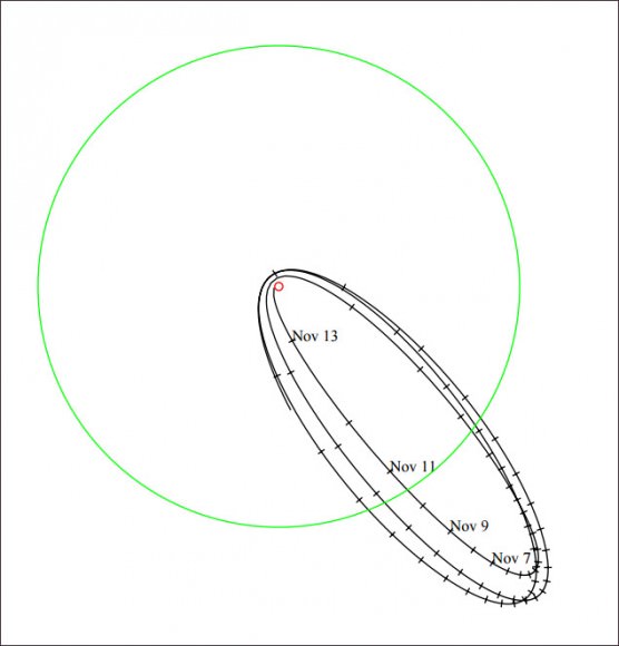
Below a plot of the last three orbits of WT1190F. The small red circle is the earth. The big green circle is the orbit of the moon, just to give some scale to the chart (click on it for a bigger version).
Below a plot of the last three orbits of WT1190F. The small red circle is the Earth. For scale, the large green circle is the orbit of the Moon. Notice that its final orbit takes straight into Earth. Credit: Bill Gray / Project Pluto

Additional observations of WT1190F have been made in the past few days confirming its re-entry later tonight. Checking the latest predictions on Bill Gray of Project Pluto’s page, the object will likely be visible from Europe about an hour before “touchdown”. To say it will be moving quickly across the sky is an understatement. Try about 3 arc minutes per second or 3° a minute! Very tricky to find and track something moving that fast.

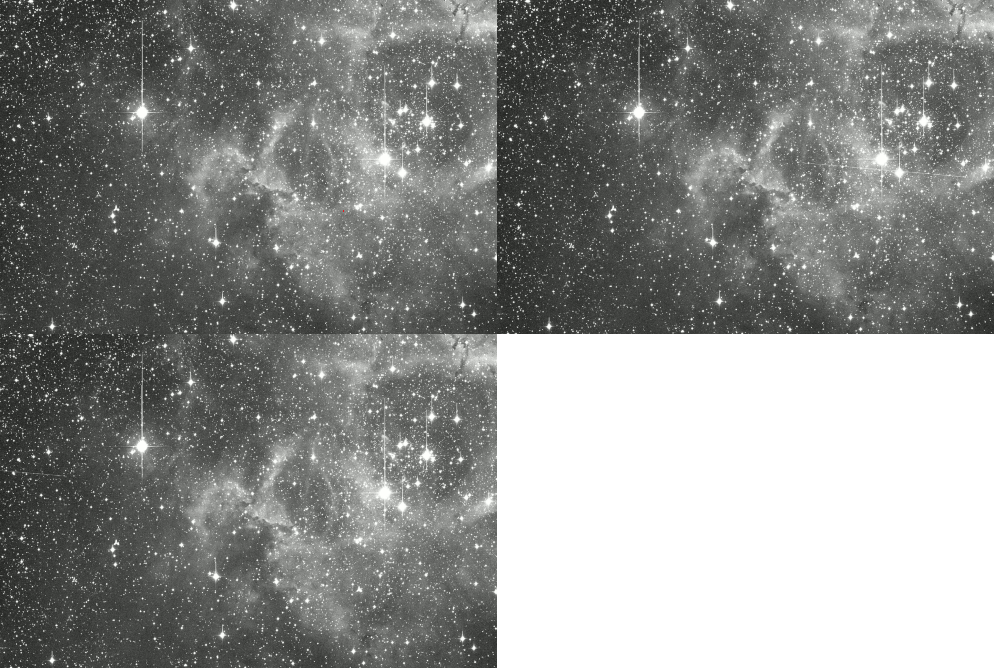
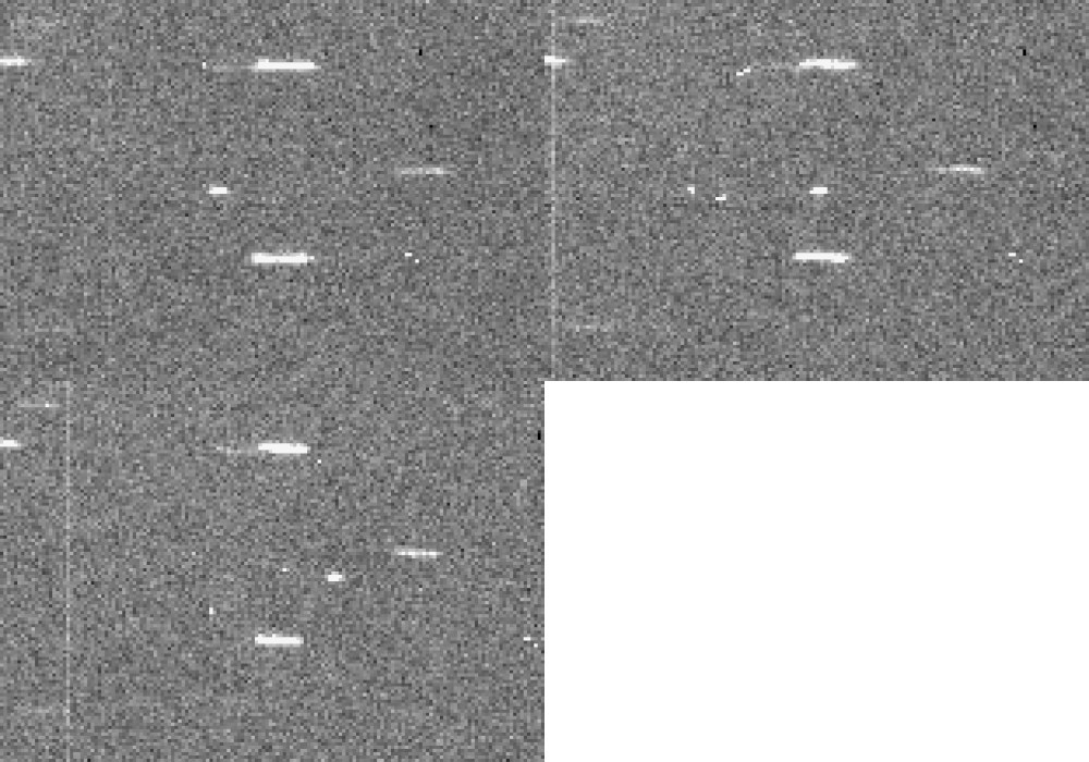
Three 90-second exposures showing WT1190F zipping across the Rosette Nebula taken on Nov. 11, 2015 at the Konkoly Observatory in Hungary. Credit: Krisztián Sárneczky

58 minutes later, in the minute of time from 6:18 to 6:19 UT,  WT1190F will move one full hour of right ascension and plummet 34° in declination while brightening from magnitude +8 to +4.5. If you’d like to attempt to find and follow the object, head over to JPL’s Horizons site  for the latest ephemerides and orbital elements. At the site, make sure that WT1190F is in the Target Body line. If not, click Change and search for WT1190F in the Target Body field at the bottom of the window.

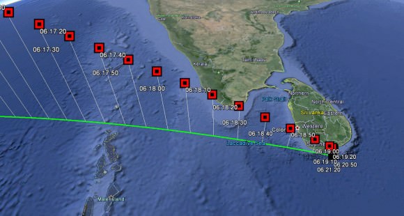
WT1190F Re-Entry Trajectory – Data courtesy of Bill Gray, Project Pluto
WT1190F re-Entry Trajectory. The object is expected to break up and fall harmlessly into the ocean. Credit: Bill Gray, Project Pluto

You’ll find updates at Bill Gray’s site. According to the most recent positions, the object will pass almost exactly in front of the Sun shortly before plunging into the ocean. Sri Lanka’s capital, Colombo, is expected to get the best views.

Because the mystery object’s arrival has been fairly well publicized, I hope to update you with a full report and photos first thing tomorrow morning. Like many of you, I wish I could see the show.

Artificial Object in Trans-lunar Orbit to Impact Earth on November 13

WT1190F observed on 9 October 2015 with the University of Hawaii 2.2 meter telescope on Mauna Kea, Hawaii. [Credits: B. Bolin, R. Jedicke, M. Micheli]

Get ready for a man-made fireball. A object discovered by the Catalina Sky Survey on Oct 3rd temporarily designated WT1190F is predicted to impact the Earth about 60 miles (100 km) off the southern coast of Sri Lanka around 6:20 Universal Time (12:20 a.m CST) on November 13.

The object orbits Earth with a period of about three weeks. Because it was also observed twice in 2013 by the same survey team, astronomers have the data they need to model its orbit and trajectory, and as far anyone can tell,  it’s likely man-made. 

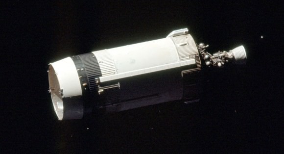
S-IVB stage of Apollo 17. Credit: NASA
The first two stages of the Saturn V rockets used to send the seven Apollo missions to the Moon fell back to Earth, but the third stage (S-IVB), pictured here, propelled the spacecraft into a lunar trajectory. Could this be WT1190F? Credit: NASA

Solar radiation pressure, the physical “push” exerted by photons of sunlight, is proportional to a space object’s area-to-mass ratio. Small, lightweight objects get pushed around more easily than heavier, denser ones. Taking that factor into account in examining WT1190F’s motion over two years, the survey team has indirectly measured WT1190F’s density at about 10% that of water. This is too low to be a typical asteroid made of rock, but a good fit with a hollow shell, possibly the upper stage of a rocket.

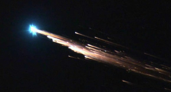
Spectacular re-entry of the Jules Verne ATV-1 cargo ship over the Pacific Ocean on September 29, 2008. Still image definition TV camera operated by Jessie Carpenter and Bill Moede of NASA Ames Research Center
Spectacular re-entry of the Jules Verne ATV-1 cargo ship over the Pacific Ocean on September 29, 2008. Still image from a TV camera operated by Jessie Carpenter and Bill Moede of NASA Ames Research Center. A similar spectacle is expected on November 13 south of Sri Lanka.

It’s also quite small, at most only about six feet or a couple of meters in diameter. Most or all of it is likely to burn up upon re-entry, creating a spectacular show for anyone near the scene. During the next week and a half, the European Space Agency’s NEO (Near-Earth Object) Coordination Center is organizing observing campaigns to collect as much data as possible on the object, according to a posting on their website. The agency has two goals: to better understand satellite re-entries from high orbits and to use the opportunity to test our readiness for a possible future event involving a real asteroid. The latter happened once before when 2008 TC3 (a real asteroid) was spotted on October 6, 2008 and predicted to strike Earth the very next day. Incredibly, it did and peppered the Sudan with meteorites that were later recovered.

Assuming WT1190F is artificial, its trans-lunar orbit (orbit that carries it beyond the Moon) hints at several possibilities. Third stages from the Saturn-V rockets that launched the Apollo missions to the Moon are still out there. It could also be a stage from one of the old Russian or more recent Chinese lunar missions. Even rockets used to give interplanetary probes a final push are game.

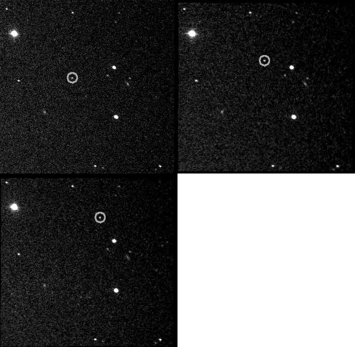
J002E3 discovery images taken by Bill Yeung on September 3, 2002. J002E3 is in the circle. Images taken with Astroworks Centurion 18" f2.8 scope and Apogee AP9e CCD camera, 10 u second exposure. Auto detected with PinPoint Astrometry Engine by Bob Denny. North is up. Animation created by Bob Denny.
Near-Earth object J002E3 discovery images taken by Bill Yeung on September 3, 2002. The 16th magnitude object was tentatively identified as the Apollo 12 third stage rocket. Animation created by Bob Denny.

Case in point. What was thought initially to be a new asteroid discovered by amateur astronomer Bill Yeung on September 3, 2002 proved a much better fit with an Apollo 12 S-IVB (third) stage after University of Arizona astronomers found that spectra taken of the object strongly correlated with absorption features seen in a combination of man-made materials including white paint, black paint, and aluminum, all consistent with Saturn V rockets.

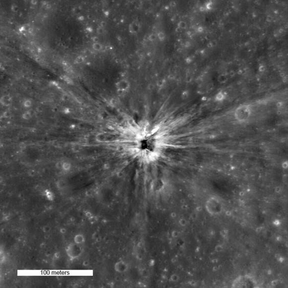
On April 14th 1970, the Apollo 13 Saturn IVB upper stage impacted the moon north of Mare Cognitum, at -2.55° latitude, -27.88° East longitude. The impact crater, which is roughly 30 meters in diameter, is clearly visible in LROC NAC image M109420042LE. Credit: NASA/Goddard/Arizona State University
On April 14th 1970, the Apollo 13 Saturn IVB upper stage impacted the moon north of Mare Cognitum. The impact crater, which is roughly 30 meters in diameter, is clearly visible in this photo taken by the Lunar Reconnaissance Orbiter. Credit: NASA/Goddard/Arizona State University

Apollo 13’s booster was the first deliberately crashed into the Moon, where it blew out it a crisp, 98-foot-wide (30-meter) crater. Why do such a crazy thing? What better way to test the seismometers left by the Apollo 12 crew? All subsequent boosters ended their lives similarly in the name of seismography. Third stages from earlier missions — Apollos 8, 10 and 11 —  entered orbit around the Sun, while Apollo 12, which is orbiting Earth, briefly masqueraded as asteroid J002E3.

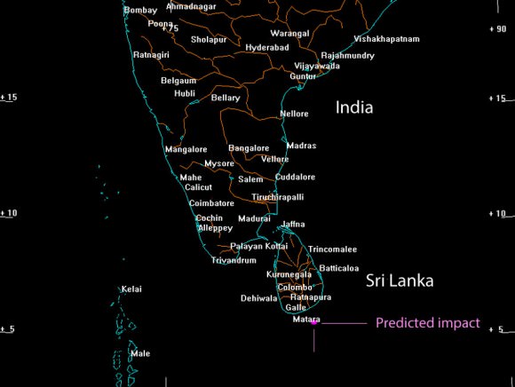
The nominal impact point is located about 60 miles south of the island nation Sri Lanka. Credit: Bill Gray at Project Pluto
The nominal impact point is located about 60 miles south of the island nation Sri Lanka. Given the object’s small size and mass, it will likely be completely incinerated during re-entry. Credit: Bill Gray at Project Pluto

Bill Gray at Project Pluto has a page up about the November 13 impact of WT1190F with more information. Satellite and asteroid watchers are hoping to track the object before and right up until it burns up in the atmosphere. Currently, it’s extremely faint and moving eastward in Orion. You can click HERE for an ephemeris giving its position at the JPL Horizons site. How exciting if we could see whatever’s coming down before its demise on Friday the 13th!

Hunting Prospero

Image credit

A relic of the early Space Age turns 44 years old this week.

The United Kingdom’s first and only successful space launch using a UK-built rocket is still visible in low Earth orbit today, if you know exact where and how to look for it.

Launched atop a 3-stage Black Arrow R3 rocket on October 28th, 1971 from the Woomera launch station in the Australian outback, Prospero (sometimes also referred to simply as the X-3) was designed to test key communications satellite technologies.

Prospero wasn’t the first satellite fielded by the United Kingdom–that credit goes to the Ariel 1 satellite launched atop a Thor DM-19 Delta rocket by the United States from Cape Canaveral on April 26th, 1962—but Prospero was notable as part of a program cut short in its early stages.

Image credit:
The launch of Prospero. Image credit: ESA

The Black Arrow project from which Prospero was born was cancelled shortly after the launch, making the X-3 the only successful mission fielded by the program (X-2 failed to achieve orbit due to an early shut-down of the stage 2 rocket). Prospero almost didn’t make it as well, as the final Waxwing stage hit the satellite upon deployment, taking one of Prospero’s four radio antennae clean off!

How to spot fainter satellites

Unlike watching for bright passes of naked eye objects in low Earth orbit such as the International Space Station, hunting for binocular satellites such as Prospero takes careful planning. Our tried and true technique is not unlike the method recently described on Universe Today to hunt for near Earth grazers such as the Halloween asteroid 2015 TB 145. In stakeout mode, you’ll need to know exactly when Prospero passes near a bright object, such as a star or planet.

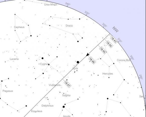
Heavens-Above is a great resource, and catalogs every satellite back through the early Space Age. And what’s really nifty is that Heavens-Above will plot the passage of the satellite showing the timing of the pass against the sky against the background of constellations and stars for your specific location.

Image credit:
A screen capture of a satellite pass from Heavens-Above. Image credit: Chris Peat/Heavens Above.com

If you have Space-Track access, you can also download the TLEs (Two Line Elements) for a particular satellite for manual entry into a program such as Starry Night or Orbitron to forecast passes. You’ll be aiming your binoculars at the target star Project Moonwatch-style at the appointed time, and simply waiting for the satellite to drift by. For precise timing, we like to listen to WWV radio broadcasting the time (in Universal or Greenwich Mean/Zulu Time) out of Fort Collins Colorado on AM shortwave 5000, 10000, 15000 and 20000 Hz. WWV radio calls out the time at the top of each minute, with time ticks for each second, allowing the observer to keep eyes on the sky continuously.  Just which WWV station comes in clearest can vary after sunset, as the ionosphere changes in terms of radio reflectivity at dusk.

Image Credit:
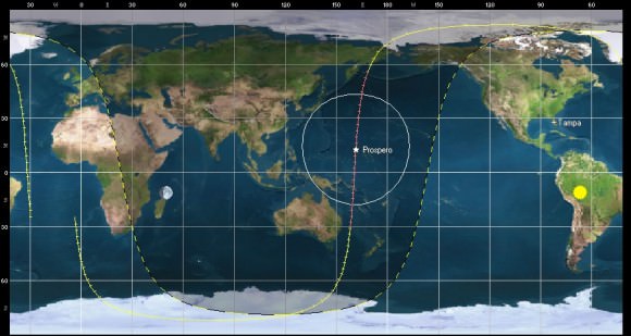
The orbital trace of Prospero. Image Credit: Orbitron

We tracked down a good pass on the errant ‘space tool bag’ lost by International Space Station astros back in 2008 using this method once it was assigned an individual NORAD ID number…  there it was, a lost tool satchel with a date with a fiery reentry destiny, drifting right by the bright star Spica at the appointed time.

Prospects for Prospero

Radio operators tracked Prospero for decades on transmission frequency 137.560 MHz until 2004, eight years past its official deactivation in 1996. As of this writing, there aren’t any official future attempts to contact Prospero in the works, though it’s certainly possible for a motivated party to do in theory… Prospero isn’t expected to reenter until 2070, and perhaps it’ll last until its centenary in space.

For latitudes 30-40 degrees north, good viewing prospects for Prospero start up again around December 20th of this year at dusk. At its brightest on a pass straight overhead through the observer’s zenith, expect Prospero to reach about +8 magnitude in brightness, well within range of binoculars. Prospero orbits Earth once every 103 minutes in a 527 by 1,304 kilometre orbit, inclined 82 degrees relative to the Earth’s equator. Prospero’s NORAD ID COSPAR designator is 1971-093A catalog number (05580).

Image credit:
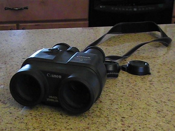
Our favorite tool for satellite hunting… Image credit: Dave Dickinson

Other relics of the Space Age are also visible in backyard near you, including:

The Vanguards: launched in starting in 1958 by the United States, The three Vanguard satellites represent the oldest bits of human artifacts in Earth orbit, and they aren’t due for reentry for another two centuries.

Allouette-1: The first Canadian satellite, launched from Vandenberg AFB in 1962 and still in orbit.

Tracking relics of the Space Age brings home the personal relevance of early space history. Looking further out towards satellites in geostationary orbit, we are seeing artifacts that may long withstand the tests of time and become the solitary testaments of our current civilization to a far off future era.

-Got a favorite relic of the Space Age you’d like us to track down? Let us know!


Atlas V Streaks to Orbit on 100th Successful Mission for ULA with Mexico’s Morelos-3

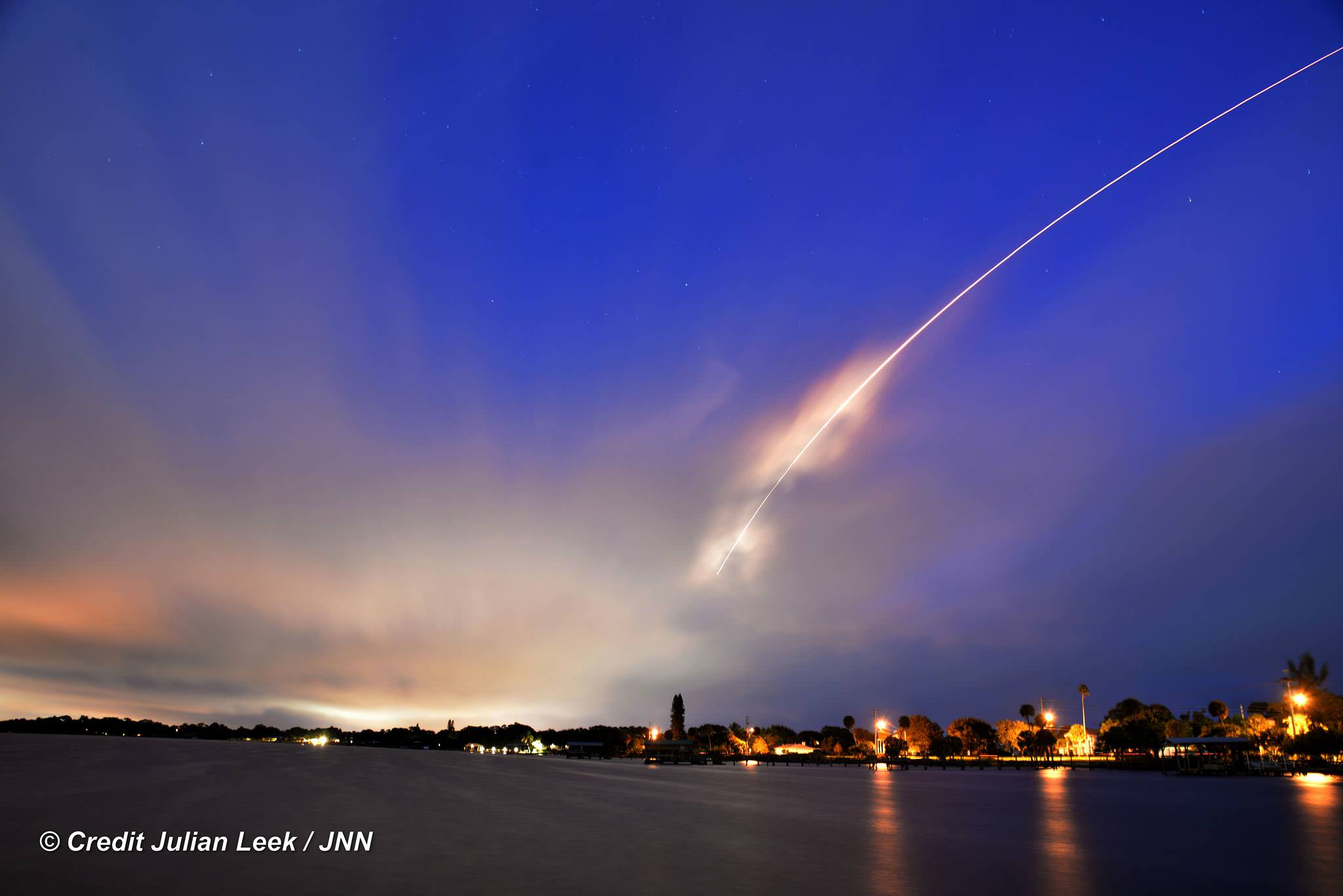
100th United Launch Alliance (ULA) rocket streaks to orbit with Atlas V booster carrying the Morelos-3 mission for Mexico from Space Launch Complex 41 on Cape Canaveral Air Force Station, Florida at 6:28 a.m. EDT, Oct. 2, 2015 as seen from Melbourne Beach pier, Florida. Credit: Julian Leek
100th United Launch Alliance (ULA) rocket streaks to orbit with Atlas V booster carrying the Morelos-3 mission for Mexico from Space Launch Complex 41 on Cape Canaveral Air Force Station, Florida at 6:28 a.m. EDT, Oct. 2, 2015 as seen from Melbourne Beach pier, Florida.  Credit: Julian Leek
100th United Launch Alliance (ULA) rocket streaks to orbit with Atlas V booster carrying the Morelos-3 mission for Mexico from Space Launch Complex 41 on Cape Canaveral Air Force Station, Florida at 6:28 a.m. EDT, Oct. 2, 2015 as seen from Melbourne Beach pier, Florida. Credit: Julian Leek
See launch photo and video gallery below

United Launch Alliance (ULA) celebrated an incredible milestone today, Oct. 2, with the successful launch of the firms 100th mission on an Atlas V rocket carrying Mexico’s next generation Morelos-3 satellite to provide advanced telecommunications for education and health programs for rural communities and secure communications for Mexican national security needs.

The spectacular predawn liftoff finally took place at 6:28 a.m. EDT from Space Launch Complex 41 on Cape Canaveral Air Force Station, Florida – after nearly being derailed by a Continue reading “Atlas V Streaks to Orbit on 100th Successful Mission for ULA with Mexico’s Morelos-3”

How to (Hopefully) Find Clear Skies for Tonight’s Total Lunar Eclipse

Weather looking a bit iffy tonight? Using the resources described below, you just might be able to escape the clouds. Credit: Bob King

We’ve arrived at eclipse day, so now the big question is, will it be clear? My favorite forecast for major astronomical events reads something like this: Fair skies tonight with light winds and lows in the middle 50s.While I hope that’s exactly what’s predicted for your town, in my corner of the world we’re expecting “increasing clouds with a chance for thunderstorms”.

That’s just not nice. Same by you? Here’s how to find that clear spot if you’re facing bad weather tonight.

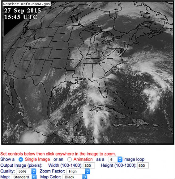
One of my favorite cloud-checking sites is the GOES East view of the U.S., Canada and Central America taken from geostationary orbit. Credit: NASA
One of my favorite cloud-checking sites is the GOES East view of the U.S., Canada and Central America taken from geostationary orbit. This map shows the scene at 10:45 a.m. CDT this morning. Credit: NASA

I usually check the GOES (Geostationary Operational Environmental Satellite) images that weather forecasters use to display and animate the movement of clouds and weather fronts during the nightly newscasts. Once I know the location and general drift of the clouds, I get in a car and drive to where it’s likely to either remain or become clear. Depending on the “magnitude” of the event I might drive 50 to 150 miles. If nothing else, doing astronomy guarantees many adventures.

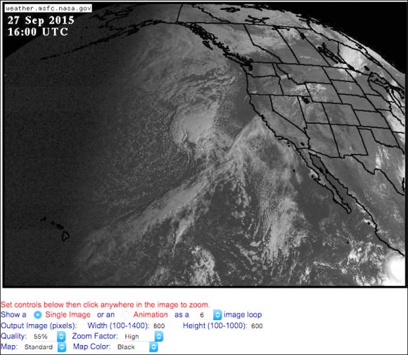
GOES West view of the western U.S., Canada and Hawaii taken at 11 a.m. CDT. Credit: NASA

You’ll find these most helpful images at either the GOES East site, which features a photo of the entire mainland U.S., Central America and much of Canada, updated every 15 minutes. Since the satellite taking the photos is centered over the 75° west parallel of longitude, its focus is primarily the eastern two-thirds of the U.S. and Canada. For the western U.S., western Canada and Hawaii, head over to the GOES West site.

After you set the width and height to maximum values, you'll get a picture like this which was taken at 11 a.m. CDT and features the upper and lower Midwest. Credit: NASA
After you set the width and height to maximum values, you’ll get a picture like this, taken at 11 a.m. CDT. Credit: NASA

Once there, you’ll be presented with a big picture view of the U.S., etc., but you can click anywhere on the map for a zoomed-in look at a particular region. Before you do, set the “width” and “height” boxes to their maximum values of 1400 (width) and 1000 (height). That way you’ll get a full-screen, nifty, 1-kilometer image when you go in close. All images have a time stamp in the upper left corner given in Universal or Greenwich Mean Time (GMT). Subtract 4 hours to convert to Easter Daylight; 5 for CDT; 6 for MDT and 7 for PDT.

You can check back all day long for fresh photos and watch the march of the clouds over time. Or you can have the site assemble up to 30 of the most recent images into an animation loop and watch it as a movie. Combing current photos, the animation and your local forecast will inform your plans about whether to remain at home to watch the eclipse or get the heck out of town.

Infrared image of the east-central U.S. at 11 a.m. CDT today. Credit: NASA
Infrared image of the east-central U.S. at 11 a.m. CDT today. Clouds can be seen and tracked at night using the infrared channel on the GOES East and West sites. Credit: NASA

When night arrives, you can still get a reasonably good idea of where the clouds are and aren’t by clicking on the infrared channel link at the top of the site. I also like to use the NCAR (National Center for Atmospheric Research Real-Time Weather Data) site. They offer a black and white infrared option that provides a clearer picture. At the site, select your “channel” then click on one of the regional acronyms on the interactive U.S. map.
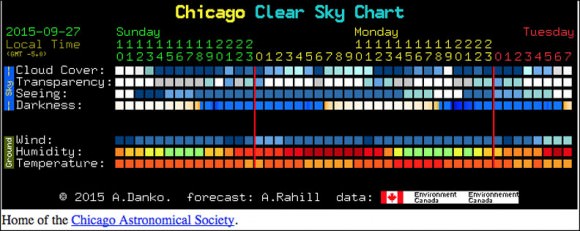
So far, we’ve been talking about the weather in real time. When it comes to forecasts, one of the most useful tools of all and a true godsend to amateur astronomers is Attilla Danko’s ClearDarkSky site. Click on the Clear Sky Charts link to access interactive charts for thousands of locations across the U.S., Canada and parts of Mexico. For example, if you click on Illinois, you’ll get a list of sky conditions for 105 locations throughout the state. The Chicago link pops up six rows of data-packed squares with colors ranging from deep blue to white.

The cloud cover forecast for Chicago for the next day as depicted in Attilla Danko's Clear Dark Sky site. Copyright: Attilla Danko
The cloud cover forecast for Chicago today Sept. 27 through early Tuesday Sept. 29 as depicted in Attilla Danko’s Clear Dark Sky site. The forecasts can be sponsored for a donation by various groups or individuals. This one is by the Chicago Astronomical Society. Copyright: Attilla Danko

The first row indicates cloud clover with varying shades of blue representing the percentage of clear sky. Medium blue means partly cloudy; white indicates 100% overcast. Additional data sets include sky transparency, seeing conditions, hours of darkness, wind, temperature and humidity. While no forecast is 100% accurate, the reliability of the models Danko uses makes Clear Sky Charts one of best tools available for skywatchers. Want a real treat? If you click on one of the squares in the Cloud Cover row, a large image showing cloud cover at the time will pop up. You’ll also find another, more general interactive cloud forecast graphic at WeatherForYou.com.

Thanks to a helpful reader suggestion, I recently learned of Clear Outside, a forecasting site similar to Clear Sky Charts but worldwide. Be sure to check it out. Satellite imagery like the U.S. GOES East and West is available for European and African observers at Sat24.

So what does the U.S. look like for weather tonight? Mostly clear skies are expected from New York State up through Maine, across the center of the country, the desert Southwest and the Northwest. Expect partly cloudy conditions (with some mostly cloudy spots) for the Upper and central Midwest, and mostly cloudy to overcast skies in the southern and southeastern seaboard states.

But who knows? By using these sites, you might just improve your chances of seeing what promises to be a spectacular lunar eclipse tonight. Some of you reading this undoubtedly have your own favorite weather hangouts. Please share them with us in the comments section. The more the merrier!

As always, if you’re completely shut out, here are a few sites where you can watch it live on the Web:

Remembering the Vela Incident

Image credit:

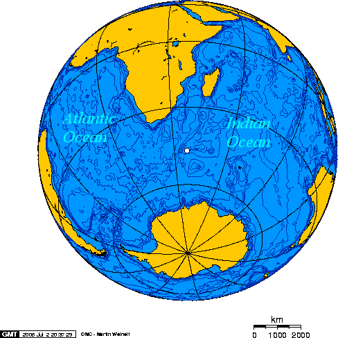
36 years ago today, a strange event was detected over the Southern Indian Ocean that remains controversial. On September 22nd, 1979, an American Vela Hotel satellite detected an atmospheric explosion over the southern Indian Ocean near the Prince Edward Islands. The event occurred at 00:53 Universal Time on the pre-dawn nighttime side of the Earth. Vela’s gamma-ray and x-ray detectors rang out in surprise, along with its two radiometers (known as Bhangmeters) which also captured the event.

Image credit:
The approximate location of the flash seen by the Vela-5b satellite Image credit: Wikimedia Commons/public domain

What was it?

Even today, the source of the Vela Incident remains a mystery. Designed to detect nuclear detonations worldwide and enforce the Partial Nuclear Test Ban Treaty, the Vela satellites operated for about ten years and were also famous for discovering evidence for extra-galactic gamma-ray bursts.

Image credit:
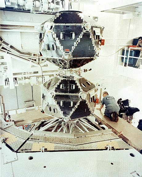
A Vela payload in the lab. Image credit: The U.S. Department of Defense

Vela-5B was the spacecraft from the series that detected the mysterious flash. A Titan-3C rocket launched Vela 5B (NORAD ID 1969-046E) on May 23rd, 1969 from Vandenberg Air Force Base in California.

One of the first things scientists realized early on in the Cold War is that the Universe is a noisy place, and that this extends across the electromagnetic spectrum. Meteors, lightning, cosmic rays and even distant astrophysical sources can seem to mimic certain signature aspects of nuclear detonations. The ability to discern the difference between human-made and natural events became of paramount importance and remains so to this day: the hypothetical scenario of a Chelyabinsk-style event over two nuclear armed states already on a political hair-trigger edge is a case in point.

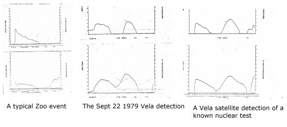
Over the years, the prime suspect for the Vela Incident has been a joint South African-Israeli nuclear test. The chief piece of evidence is the characteristic ‘double-flash’ recorded by Vela, characteristic of a nuclear detonation. Said event would’ve been an approximately 3 kiloton explosion; for context, the bomb dropped on Hiroshima had a 15 kiloton yield, and the Chelyabinsk event had an estimated equivalent explosive force of 500 kilotons. As a matter of fact, the Vela Incident became a topic of discussion on the day Chelyabinsk occurred, as we sought to verify the assertion of whether Chelyabinsk was ‘the biggest thing’ since the 1908 Tunguska event.

Image credit:
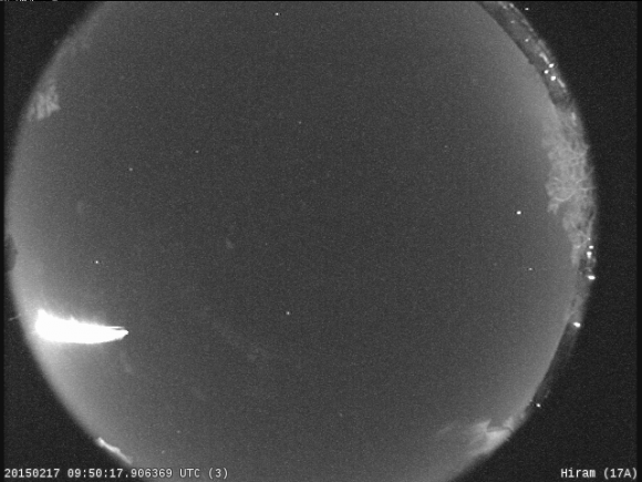
A bolide event captured over Pennsylvania in early 2015. Image credit: Bill Ingalls/NASA

The Carter administration played down the Vela Incident at the time, though U.S. Air Force dispatched several WC-135B surveillance aircraft to the area, which turned up naught. Though detectors worldwide reported no increase of radioactive fallout, the ionospheric observatory at Arecibo did detect an atmospheric wave on the same morning as the event.

Israel ratified the Limited Test Ban Treaty in 1964. To date, Israel has never acknowledged that the test took place or the possession of nuclear weapons. Over the years, other suspect states have included Pakistan, France and India. Today, probably the only true final confirmation would come from someone stepping forward who was directly involved with the test, as it must have required the silence of a large number of personnel.

Image credit:
A comparison of the Vela event with a known nuclear test and a typical “zoo event’. Image credit: Vela Event Alert 747, Los Alamos Nat’l Laboratory

Was it a reentry or a bolide? Again, the signature double flash seen by the Vela satellite makes it unlikely. A micrometeoroid striking the spacecraft could have caused an anomalous detection known as a ‘zoo event,’ mimicking a nuclear test. Los Alamos researchers who have analyzed the event over the years remain convinced in the assertion that the 1979 Vela Incident had all the hallmark signatures of a nuclear test.

Image credit:
A U.S. nuclear detonation during Operation Upshot-Knothole in 1953. Image credit: National Nuclear Security Administration/Public Domain

Shortly after the Cold War, the U.S. Department of Defense made much of its atmospheric monitoring data public, revealing that small meteorites strike us much more often than realized. Sadly, this type of continual monitoring accompanied by public data release has declined in recent years mostly due to budgetary concerns, though monitoring of the worldwide environment for nuclear testing via acoustic microphone on land, sea and eyes overhead in space continues.

And it’s frightening to think how close we came to a nuclear exchange during the Cold War on several occasions. For example: in 1960, an Distant Early Warning System based in Thule, Greenland mistook the rising Moon for a Soviet missile launch (!) The United States also conducted nuclear tests in space shortly before the Test Ban Treaty went into effect, including Starfish Prime:

The Vela Incident remains a fascinating chapter of the Cold War, one where space and the geopolitical intrigue overlap. Even today, parsing out the difference between human-made explosions and the cataclysmic events that pepper the cosmos remains a primary concern for the continued preservation of our civilization.

Image credit: Dave Dickinson
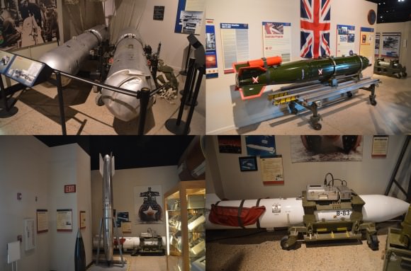
Tactical nuclear weapons from around the world seen on display at the Nuclear Science Museum in Albuquerque, New Mexico. Image credit: Dave Dickinson

-Listen to an interesting discussion on monitoring nuclear plants worldwide via neutrino emissions.

-For a fascinating in-depth discussion on the continued relevance of the Vela Incident, check out this recent article by The Bulletin of Atomic Scientists.

More Spectacular Images from the MUOS-4 Launch

Stunning downrange plume over the rising sun, about 3 mins after launch of the MUOS-4 satellite from Space Launch Complex 41 in Florida. Used by permission. Credit and copyright: Mike Seeley.

Skywatchers across Central Florida got an unusual view early Wednesday morning in conjunction with the Atlas V launch of the MUOS-4 satellite.

“That wasn’t thunder this AM, Florida: An absolutely stunning MUOS launch!” tweeted photographer Michael Seeley, who shared several images of the launch with Universe Today. Mike is a freelance photographer and works with Spaceflight Insider. You can see more of his imagery at his website.

The pre-dawn light combined with unusual atmospheric conditions produced stunning views both during and well after the launch. The skyshow was visible across a wide area.

“Folks as far south as Miami and up to Jacksonville to the north saw it,” Universe Today’s David Dickinson said. “I even heard kids waiting for the school bus on our street crying out in surprise!”

You can read more about the launch and the mission in our article from Ken Kremer, but see a stunning gallery of images of the unusual cloud formations following the launch below:

A long exposure image of the light trail from the Atlas V launch of the MUOS-4 satellite, as seen from the ITL Causeway. Image used by permission. Credit and copyright: Mike Seeley.
A long exposure image of the light trail from the Atlas V launch of the MUOS-4 satellite, as seen from the ITL Causeway. Image used by permission. Credit and copyright: Michael Seeley.
A closeup view of the Atlas V MUOS-4 launch by United Launch Alliance. Image used by permission. Credit and copyright: Michael Seeley.

Below are a group of images and video from UT’s David Dickinson, taken about 100 miles away from Cape Canaveral in Hudson, Florida:

The launch of the MUOS-4 satellite from Cape Canaveral, Florida on September 2, 2015 created an unusual noctilucent cloud display, visible even from 100 miles away. Credit and copyright: David Dickinson.
Remaining noctilucent clouds about 25 minutes after the launch of the MUOS-4 satellite on board an Atlas V rocket on September 2, 2015. Image taken from Hudson, Florida, about 100 miles west of Cape Canaveral. Credit and copyright: David Dickinson.

A view from Hudson, Florida, about 100 miles west of Cape Canaveral after the launch of the MUOS-4 Satellite on September 2, 2015. Credit and copyright: David Dickinson.
An Atlas V rocket carrying the MUOS-4 mission lifts off from Space Launch Complex 41, creating a unique light display. Sept. 2, 2015. Credit: ULA.

This is Our Planet From a Million Miles Away

Earth imaged on July 6, 2015 by NOAA's DSCOVR satellite from L1. Credit: NOAA/NASA/GSFC

This picture of our home planet truly is EPIC – literally! The full-globe image was acquired with NASA’s Earth Polychromatic Imaging Camera (aka EPIC; see what they did there) on board NOAA’s DSCOVR spacecraft, positioned nearly a million miles (1.5 million km) away at L1.

L1 is one of five Lagrange points that exist in space where the gravitational pull between Earth and the Sun are sort of canceled out, allowing spacecraft to be “parked” there. (Learn more about Lagrange points here.) Launched aboard a SpaceX Falcon 9 on Feb. 11, 2015, the Deep Space Climate Observatory (DSCOVR) arrived at L1 on June 8 and, after a series of instrument checks, captured the image of Earth’s western hemisphere above on July 6.

The EPIC instrument has the capability to capture images in ten narrowband channels from infrared to ultraviolet; the true-color picture above was made from images acquired in red, green, and blue visible-light wavelengths.

More than just a pretty picture of our blue marble, this image will be used by the EPIC team to help calibrate the instrument to remove some of the blue atmospheric haze from subsequent images. Once the camera is fully set to begin operations daily images of our planet will be made available on a dedicated web site starting in September.

DSCOVR's location at L1 (NOAA/NASA)
DSCOVR’s location at L1 (NOAA/NASA)

Designed to provide early warnings of potentially-disruptive geomagnetic storms resulting from solar outbursts, DSCOVR also carries Earth-observing instruments that will monitor ozone and aerosols in the atmosphere and measure the amount of energy received, reflected, and emitted by Earth – the planet’s “energy budget.

But also, from its permanent location a million miles away, DSCOVR will be able to get some truly beautiful – er, EPIC – images of our world.

DSCOVR is a joint mission between NOAA, NASA, and the U.S. Air Force. Learn more about DSCOVR here.

Source: NASA

UPDATE: President Obama liked this image so much, he decided to Tweet about it with a message of planetary conservation!

The POTUS' Tweet about the DSCOVR image on July 20, 2015.
The POTUS’ Tweet about the DSCOVR image on July 20, 2015.

UPDATE 7/29/15: Here’s another view from DSCOVR on July 6, showing Europe, Africa, and the Middle East:

DSCOVR image of Earth from July 6, 2015. (NASA/NOAA)