Citizen Science, Old-School Style: The True Tale of Operation Moonwatch

An Operation Moonwatch team in action based out of Terre Haute, Indiana. (Courtesy of Keep Watching the Skies! Author Patrick McCray, used with Permission).

Amateur astronomers have done more than just watch the skies, they’ve been a national security asset. In the mid-1950’s, it was realized that the reality of the Space Age was at best only a decade away. Sub-orbital German V-2 rockets captured by the Soviets and the United States were reaching higher and higher altitudes, and it was only a matter of time before orbital velocity would be achieved.

Keep in mind, this was the age of backyard bomb shelters, “duck and cover” drills, and civil preparedness as Cold War fever reached a heightened pitch. Ground Observer Corps encouraged and trained citizen groups how to spot and report enemy bombers approaching the U.S coast in preparation for a nuclear confrontation. And remember, there was no reason to think that this build up wouldn’t extend to the militarization of space. It was in this era that Operation Moonwatch was born.

Conceived by Harvard astronomer Fred Whipple, Operation Moonwatch was the “Galaxy Zoo” of its day. The idea was simple; teams of observers around the world would track, time and record satellite passes over their location and feed this data back to the computation center at Cambridge, Massachusetts (telephone, Western Union or ham radio were the methods of the day) This data would give engineers information as to where to point their enormous Baker-Nunn cameras. These instruments were wide-field Schmidt cameras that could cover large swaths of the sky. They were to be positioned at 12 locations worldwide to keep tabs on satellites in low Earth orbit (LEO).
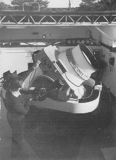
A Baker-Nunn satellite tracking camera ready for action. (Credit: NASA).

To be sure, there were obstacles to overcome. The Baker-Nunn cameras were well behind schedule, and the entire system was struggling to come online by mid-1958 in time for the International Geophysical Year (IGY). School and community groups had to be organized, trained, and equipped. Knowing precise location in the pre-GPS era had to be addressed. Many purchased optical kits available from Radio Shack, while many teams built their own. Then there was the dilemma of what a satellite would actually look like to an observer on the ground. Could a trained spotter even see it? Civil Air Patrol groups experimented with various trial substitutions, such as following aircraft, flocks of birds and bats at dusk and even tracking pebbles tossed into the sky!

Operation Moonwatch was also to play a part of the 1958 International Geophysical Year. Many doubted to effectiveness of amateur groups, but public interest ran high. Then on October 4th 1957, the world was caught off guard as Sputnik 1 lifted off from the Baikonur Cosmodrome.
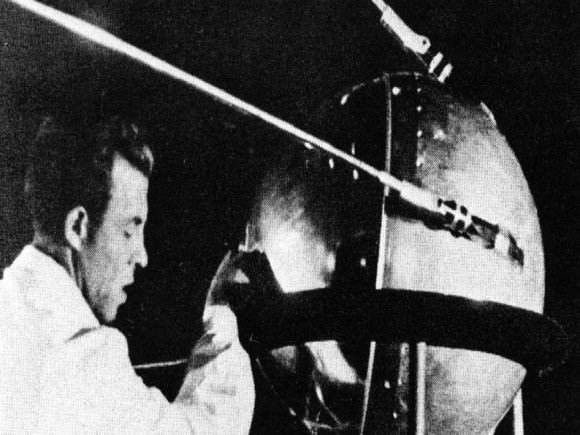
The metal ball that started it all... Sputnik 1. (Credit: NASA/Asif A. Siddiqi).
The metal ball that started it all… Sputnik 1. (Credit: NASA/Asif A. Siddiqi).

The world was stunned that the Soviets had beaten the West into space. The National Advisory Committee for Aeronautics (later to become NASA in 1958) had yet to achieve a successful orbital launch, and the United States Naval Research Laboratory was still floundering to get the Vanguard program off the pad. The launch of Sputnik found a scant few Moonwatch teams at the ready to catch its first dusk passes over the United States. Keep in mind, the Sputnik satellite was too small and faint to see with the naked eye. What most casual observers in the general public saw (remember the opening scenes in the movie October Sky?) was actually the rocket booster that put Sputnik into space.

Moonwatch teams would “look up by looking down” using a bench mounted telescope that looked at a reflective plate aimed skyward. With observers arranged in a row aimed at a picket line, they would call out when the target satellite crossed the local meridian. This would in turn be documented by an onsite recorder for transmission.
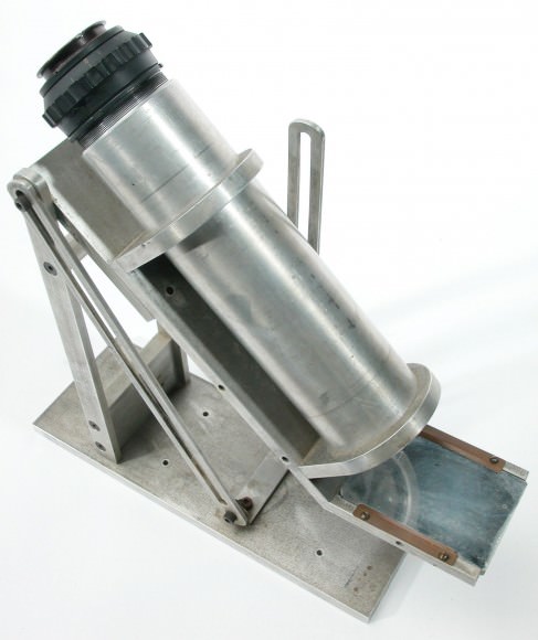
A classic Operation Moonwatch bench instrument sold by Edmund Scientifc. (Credit: The Smithsonian Natinal Air & Space Museum).
A classic Operation Moonwatch bench instrument sold by Edmund Scientific  (Credit: The Smithsonian National Air & Space Museum).

With Sputnik, the Operation Moonwatch volunteers found themselves thrust into the spotlight. Newspapers & radio shows clamored to interview volunteers, as the public suddenly became obsessed with space. Moonwatchers followed and documented to launch of the dog Laika aboard Sputnik 2 on November 3rd, 1957, and when the U.S. finally launched its first satellite Explorer I on February 1st 1958 Operation Moonwatch tracked it. Magazines such as National Geographic and Boys Life ran articles on the project and told teams how they could participate. When Sputnik 4 reentered over the U.S. on September 1962, it was data from Operation Moonwatch observers that proved vital in its recovery.
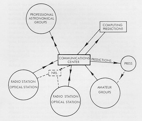
How Operation Moonwatch fit into the hierarchy. (Credit: NASA archives, The Role of the NAS & TPESP).
How Operation Moonwatch fit into the hierarchy. Note how amateur groups were associated with this press. (Credit: NASA archives, The Role of the NAS & TPESP).

Moonwatch was disbanded in 1975, but many volunteers continued tracking satellites and sharing data on their own. I always think that it’s fascinating that three very early satellites from the early days of Operation Moonwatch are still in orbit and can been seen with a good pair of binoculars and a little patience , Vanguards 1, 2 & 3. It could be argued that Operation Moonwatch provided a civilian means to monitor the goings on of governments in low Earth orbit and may have contributed to the Outer Space Treaty outlawing the use of nuclear weapons in space. Another fortunate occurrence of the era was the establishment of a civilian space agency in the U.S., argued for successfully by Dr. James Van Allen. How different would the course of history have been if the U.S. space program had become a “fourth branch” of the military?

Cincinnati plaque commemorating Operation Moonwatch. (Brian Van Flandern Public Domain image).

Today, modern satellite trackers still follow, image and share information on satellites worldwide. This effort transcends borders; when hazardous payloads such as Russia’s failed Mars mission Phobos-Grunt reentered in early 2012 satellite trackers documented its final passage, and efforts are still underway to keep tabs on the USAF’s X-37 spy satellite. One can also see a stark contrast between the efforts to enlist civilian effort during the Cold War and the modern Global War on Terrorism. Interest in science was at an all-time high in the 1950’s, as it was realized the West might be lagging behind in science education. In a post-9/11 era, there almost seems to be a movement to isolate participation. Many model rocketry groups are under increased restriction, and even amateur astronomers may see essential tools such as green laser pointers restricted for use.
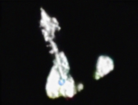
Image of Space Shuttle Discovery on STS-119 captured from the ground... note the NASA "Blue Meatball" logo on the wing! (Credit Ralf Vandebergh, used with permission).
Image of Space Shuttle Discovery on STS-119 captured from the ground… note the NASA “Blue Meatball” logo on the wing! (Credit:  Ralf Vandebergh, used with permission).

But the good news is, anyone can still track a satellite from the comfort of their own backyard all in the spirit of Operation Moonwatch. DARPA announced a project last year which may resurrect a program similar to Operation Moonwatch. Named SpaceView, this program seeks to augment the U.S. Air Force’s Space Surveillance Network. Keep an eye on the sky, and remember a dedicated few amateur observers that played a crucial role in modern history as you watch satellites drift silently by in the twilight skies.

For more on the fscinating hostory of Operation Moonwatch, read Patrick McCray’s Keep Watching the Skies!

See more of Ralf Vandebergh’s outstanding work at his site Telescopic Spaceflight Images.

Chinese Space Debris Collides with Russian Satellite

According to Analytical Graphics, Inc. (AGI), the Center for Space Standards and Innovation (CSSI) has determined that on January 22, 2013 debris from the Chinese FENGYUN 1C collided with Russia’s BLITS satellite. The FENGYUAN 1C is the satellite that was destroyed by China on January 11, 2007 in a test of an anti-satellite missile. The collision changed the orbit of the Russian satellite, along with its spin velocity and attitude. The animation above is from AGI and it depicts the event.
Continue reading “Chinese Space Debris Collides with Russian Satellite”

12 Star Party Secret Weapons

Awaiting sunset... (Photo by author).

We’ve all been there. Well OK, all public star party telescope operators have been there. You’re set up and you’ve got a stunning view of Saturn centered in the field of view. But then the first member of the viewing public takes a quick glance and steps back from the eyepiece, stating “yeah, I saw that through the last four ‘scopes…”

What do you do when every telescope down the row is aimed at the same object? Or worse yet, what do you aim at when there is no Moon or bright planets above the horizon? Every seasoned telescope operator has a quick repertoire of secret favorites, little known but sure-fire crowd pleasers.  Sure, Saturn is awesome and you should see it through a telescope… but it’s a big universe out there. 

I’ve even seen clubs assign objects to individual telescopes to avoid having everyone point at the same thing, but this method is, well, boring for the scope operators themselves.  Most backyard astronomers can simply look at a tube pointed at Orion and know the neighboring telescope is aimed at the Orion Nebula. What follows is our very own highly subjective (but tested in the field!) list of secret star party faves. Yes, it is mid-northern latitude-centric. It also covers a span of objects of all types, as well as a handy information chart of where in the sky to find ‘em and a few surprises. We also realize that many public star parties often take place downtown under light polluted skies, so a majority of these are brighter objects.  Don’t see your favorite? Drop us a line and let us know!

12. The Double Cluster:  Straddling the border of the constellations Perseus and Cassiopeia, this pair of clusters is a fine sight at low power. The technical designation of the pair is NGC 884 and NGC 869 respectively and the clusters sit about 7000 light years distant.  You can just see the pair with the naked eye under suburban skies.

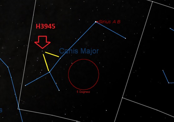
The location of Herschel 3945 in Canis Major. (Created by Author in Starry Night).

11. Herschel 3945:  A popular summer-to-fall star party target is the colored double star Albireo is the constellation Cygnus. But did you know there’s a similar target visible early in the year as well? I call Herschel 3945 the “winter Albireo” for just this reason. This 27” split pair of sapphire and orange stars offers a great contrast sure to bring out the “ohs” and “ahs.” Continue reading “12 Star Party Secret Weapons”

5 Landsat Pictures That Changed the World

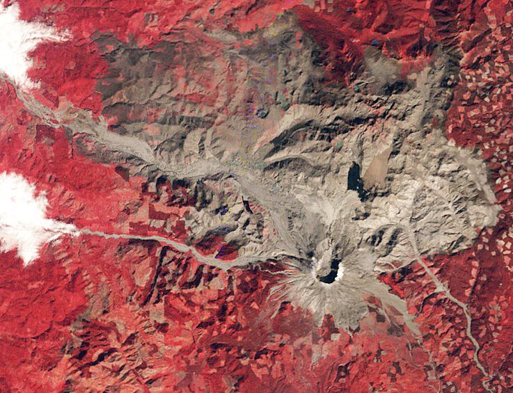
Mount St. Helens shortly after its eruption in 1980. Credit: Landsat

Turn a camera to a location for four decades, and you can see a lot of change. Streets appear or disappear. Trees grow and eventually, die. Houses spring up and slowly decay.

Landsat is the longest-running Earth observation program, with four decades of observations behind it. Today, to celebrate the launch of Landsat 5 on this day in 1984, here are five Landsat images that helped us better understand the Earth and at times, how humans affect its environment.

Mount St. Helens


When Washington State’s Mount St. Helens exploded in May 1980, it killed 57 people and obliterated much of the surrounding countryside. For American volcanologists, however, St. Helens was an easy target to study both up close and with the Landsat satellite. This 1980 image shows the devastated countryside in the weeks after the eruption. Landsat photos from every year since demonstrate how the area has recovered in the past two decades.

3-D Antarctica

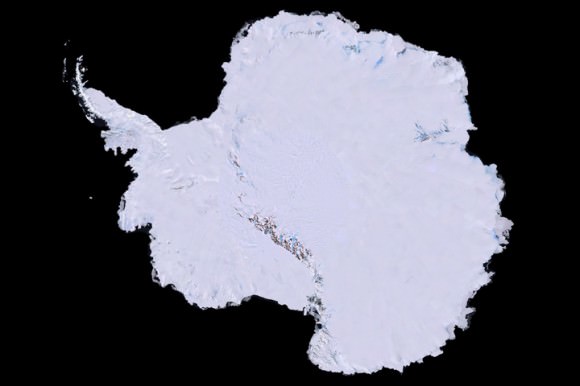
A 3-D map of Antarctica using 1,100 images from the Landsat 7 satellite. Credit: Landsat
A 3-D map of Antarctica using 1,100 images from the Landsat 7 satellite. Credit: Landsat/USGS

That image up there was years in the making. First, scientists collected 1,100 images of Antarctica using the Landsat 7 satellite. That process took three years, between 1999 and 2001. They combined elevation data and field measurements. Next came the painstaking process of stitching it together. It was finally released to the public in 2007. An unexpected benefit? Spying the continent from space allowed scientists to better track Emperor penguins. That brown stain on the image is actually where the penguins were sitting when the pictures were taken.

Rushing to Kuwait’s rescue

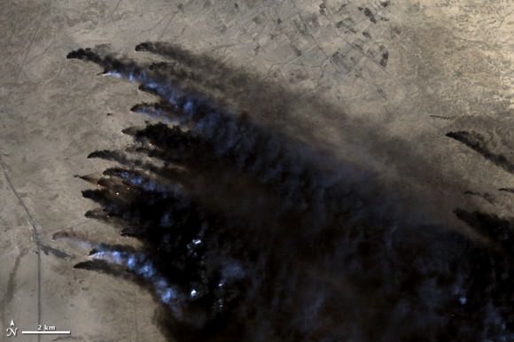
Oil well fires burn in Kuwait during the 1991 Persian Gulf War. Credit: Landsat
Oil well fires burn in Kuwait during the 1991 Persian Gulf War. Credit: Landsat/USGS

As Iraq pulled out from Kuwait during the Persian Gulf War in 1991, Iraqi troops set fire to some 650 oil wells. The environmental devastation was enormous. This Landsat image, among many others, was crucial for Kuwaiti emergency responders to figure out where the fires were burning and how best to approach them.

Landsat’s Van Gogh image

NASA once compared this image of phytoplankton surrounding Gotland to Vincent Van Gogh's "Starry Night." Credit: Landsat
NASA once compared this image of phytoplankton surrounding Gotland to Vincent Van Gogh’s “Starry Night.” Credit: Landsat/USGS

Are those stars and nebulas we see above? Not quite, but NASA points out it does look very similar to the Vincent Van Gogh image “Starry Night.” That 2005 snapshot from Landsat 7 actually shows phytoplankton surrounding the Swedish island of Gotland in the Baltic Sea. The picture was voted the top snapshot by NASA visitors to the “Earth As Art” contest held in 2012.

Shrinking Aral Sea

The Aral Sea has shrunk to half its size in just 40 years. Credit: Landsat
The Aral Sea has shrunk to half its size in just 40 years. Credit: Landsat/USGS

The series of Landsat images above show just how much of the Aral Sea disappeared between 1977 and 2006. The body of water, located between Uzbekistan (south) and Kazakhstan, used to be the fourth-largest lake in the world. The Soviets tapped into the sea several decades ago to irrigate the surrounding area. While local authorities are working to reverse the damage, the sea is still about half the size it used to be.

There’s more Landsat magic to come in the next few years. The Landsat Data Continuity Mission left Earth last month and will take more pictures of the Earth in even better resolution than its ancestors. Take a look at its launch video below.

Curiosity Mars Rover Eats 1st Sample of Gray Rocky Powder

NASA's Mars rover Curiosity took this image of Curiosity's sample-processing and delivery tool just after the tool delivered a portion of powdered rock into the rover's Sample Analysis at Mars (SAM) instrument. This Collection and Handling for In-situ Martian Rock Analysis (CHIMRA) tool delivered portions of the first sample ever acquired from the interior of a rock on Mars into both SAM and the rover's Chemistry and Mineralogy (CheMin) instrument. Credit: NASA/JPL-Caltech/MSSS

NASA’s Curiosity rover has eaten the 1st ever samples of gray rocky powder cored from the interior of a Martian rock.

The robotic arm delivered aspirin sized samples of the pulverized powder to the rover’s Chemistry and Mineralogy (CheMin) and Sample Analysis at Mars (SAM) instruments this past weekend on Feb. 22 and 23, or Sols 195 and 196 respectively.

Both of Curiosity’s chemistry labs have already begun analyzing the samples – but don’t expect results anytime soon because of the complexity of the operation involved.

“Analysis has begun and could take weeks,’ NASA JPL spokesman Guy Webster told Universe Today.

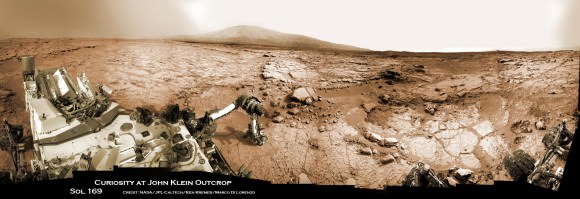
The samples were collected from the rover’s 1st drilling site known as ‘John Klein’ – comprised of a red colored slab of flat, fine-grained, sedimentary bedrock shot through with mineral veins of Calcium Sulfate that formed in water.

“Data from the instruments have confirmed the deliveries,” said Curiosity Mission Manager Jennifer Trosper of NASA’s Jet Propulsion Laboratory, Pasadena, Calif.

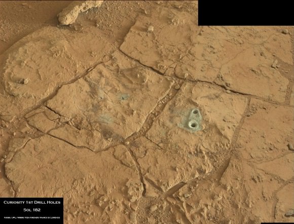
On Feb. 8, 2013 (mission Sol 182), Curiosity used the rotary-percussion drill mounted on the tool turret at the end of the 7 foot (2.1 meter) long robotic arm to bore a circular hole about 0.63 inch (16 mm) wide and about 2.5 inches (64 mm) deep into ‘John Klein’ that produced a slurry of gray tailings

Curiosity accomplished Historic 1st drilling into Martian rock at John Klein outcrop on Feb 8, 2013 (Sol 182), shown in this context mosaic view of the Yellowknife Bay basin taken on Jan. 26 (Sol 169) where the robot is currently working. The robotic arm is pressing down on the surface at John Klein outcrop of veined hydrated minerals - dramatically back dropped with  her ultimate destination; Mount Sharp.  Credit: NASA/JPL-Caltech/Ken Kremer/Marco Di Lorenzo
Curiosity accomplished Historic 1st drilling into Martian rock at John Klein outcrop on Feb 8, 2013 (Sol 182), shown in this context mosaic view of the Yellowknife Bay basin taken on Jan. 26 (Sol 169) where the robot is currently working. The robotic arm is pressing down on the surface at John Klein outcrop of veined hydrated minerals – dramatically back dropped with her ultimate destination; Mount Sharp. Credit: NASA/JPL-Caltech/Ken Kremer/Marco Di Lorenzo

The gray colored tailings give a completely fresh insight into Mars that offers a stark contrast to the prevailing views of reddish-orange rusty, oxidized dust.

The eventual results from SAM and CheMin may give clues about what exactly does the color change mean. One theory is that it might be related to different oxidations states of iron that could potentially inform us about the habitability of Mars insides the rover’s Gale Crater landing site.

“The rock drilling capability is a significant advancement. It allows us to go beyond the surface layer of the rock, unlocking a time capsule of evidence about the state of Mars going back 3 or 4 Billion years,” said Louise Jandura of JPL and Curiosity’s chief engineer for the sampling system.

Additional portions of the first John Klein sample could be delivered to SAM and CheMin if the results warrant. The state-of-the-art instruments are testing the gray powder to elucidate the chemical composition and search for simple and complex organic molecules based on carbon, which are the building blocks of life as we know it.

Curiosity’s Mastcam camera snapped this photo mosaic of 1st drill holes into Martian rock at John Klein outcrop inside Yellowknife Bay basin where the robot is currently working. Notice the gray powdery tailings from the rocks interior. Credit: NASA/JPL-Caltech/Ken Kremer/Marco Di Lorenzo
Curiosity’s Mastcam camera snapped this photo mosaic of 1st drill holes into Martian rock at John Klein outcrop inside Yellowknife Bay basin where the robot is currently working. Notice the gray powdery tailings from the rocks interior. Credit: NASA/JPL-Caltech/MSSS/Ken Kremer/Marco Di Lorenzo

The Curiosity science team believes that this work area inside Gale Crater called Yellowknife Bay, experienced repeated percolation of flowing liquid water long ago when Mars was warmer and wetter – and therefore was potentially more hospitable to the possible evolution of life.

Curiosity is nearly 7 months into her 2 year long primary mission. So far she has snapped over 45,000 images.

“The mission is discovery driven,” says John Grotzinger, the Curiosity mission’s chief scientist of the California Institute of Technology.

The rover will likely remain in the John Klein area for several more weeks to a month or more to obtain a more complete scientific characterization of the area which has seen repeated episodes of flowing water.

Eventually, the six-wheeled mega rover will set off on a nearly year long trek to her main destination – the sedimentary layers of the lower reaches of the 3 mile (5 km) high mountain named Mount Sharp – some 6 miles (10 km) away.

Ken Kremer

Spotting the Dragon: How to See SpaceX on Approach to the ISS This Weekend

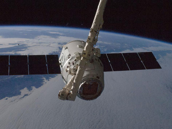
Capture of the Dragon during the October 2012 CRS-1 mission. (Credit: NASA/ISS).

SpaceX’s Dragon spacecraft may be appearing in a backyard sky near you this weekend. Scheduled to launch this Friday on March 1st at 10:10 AM Eastern Standard Time (EST)/15:10 Universal Time (UT), this will be the 3rd resupply flight for the Dragon spacecraft to the International Space Station (ISS).  And the great news is, you may just be able to catch the spacecraft as it chases down the ISS worldwide.

The Space Shuttle and the ISS captured by the author as seen from Northern Maine shortly after undocking in June, 2007. 

Catching a satellite in low Earth orbit is an unforgettable sight. Satellites appear as moving “stars” against the background sky, shining steadily (unless they’re tumbling!) in the sunlight overhead in the dawn or dusk sky. Occasionally, you may catch a flare in brightness as a reflective panel catches the sunlight just right. The Hubble Space Telescope and the Iridium constellation of satellites can flare in this fashion.

At 109 metres in size, the ISS is the largest object ever constructed in orbit and is easily visible to the naked eye. It has an angular diameter of about 50” when directly overhead (about the visual size of Saturn plus rings near opposition). I can just make out a tiny box-like structure with binoculars when it passes overhead. If the orientation of the station and its solar panels is just right, it looks like a tiny luminous Star Wars TIE fighter as viewed through binoculars!

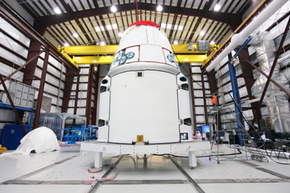
Dragon in the processing hangar at Cape Canaveral. (Credit: NASA/Kim Shiflett).

But what’s even more amazing is to watch a spacecraft rendezvous with the ISS, as diligent observers may witness this weekend. Your best bet will be to use predictions for ISS passes from your location. Heavens-Above, CALSky and Space Weather all have simple trackers for sky watchers. More advanced observers may want to use an application known as Orbitron which allows you to manually load updated Two-Line Element sets (TLEs) from Celestrak or NORAD’s Space-Track website for use in the field sans Internet connection. Note that Space-Track requires permission to access; they welcome amateur sat-spotters and educators, but they also want to assure that no “rogue entities” are accessing the site! Continue reading “Spotting the Dragon: How to See SpaceX on Approach to the ISS This Weekend”

Indian Rocket Launches Swarm of International Mini Satellites

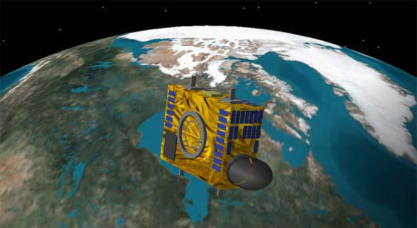
The Canadian asteroid-hunting NEOSSAT is among the fleet of satellites launched on Feb. 25, 2013.Credit: Canadian Space Agency

A Polar Satellite Launch Vehicle (PSLV) successfully launched from India today, sending seven different international satellites into orbit. Launch was at 7:31 a.m. EST (12:31 UTC) and on board were three Canadian-built spacecraft including a small asteroid-hunting satellite (weighing in at just 74 kg) called NEOSSat, other small satellites from the UK, Austria and Denmark and an India-France joint effort called SARAL, an Earth observation satellite, the primary payload for the launch.

Reports indicate all seven satellites were placed in their proper orbits and after their initial check-outs will being their missions.

NEOSSat (Near-Earth Object Surveillance Satellite)will track large asteroids that may come close to Earth and also track space debris in orbit. The suitcase-sized NEOSSat will orbit approximately 800 kilometers above the Earth, searching for objects that are difficult to spot using ground-based telescopes. Because of its location, NEOSSat will not be limited by the day-night cycle and will operate continuously.

“NEOSSat will discover many asteroids much faster than can be done from the ground alone,” said Alan Hildebrand of the University of Calgary. “Its most exciting result, however, will probably be discovering new targets for exploration by both manned and unmanned space missions.”

SARAL will be monitoring climate on Earth; CanX-3 BRITE (BRIght Target Explorer) is billed as the smallest astronomical telescope looking for faint objects; Sapphire is a military satellite that will keep track of objects orbiting between 3,800 and 25,000 miles (6,000 and 40,000 kilometers) from Earth; TUGSat-1 BRITE from Austria will monitor changes in brightness in stars; AAUSat 3 from Denmark will moniter ship traffic on Earth’s oceans, and STRaND-1 is a nanosatellite carrying a smartphone, has unique “screaming in space” experiment.

See more information on each satellite on our preview article.

Satellite Swarm — Including an Asteroid Hunter — Readies For Spaceflight

The Canadian asteroid-hunting NEOSSAT is among the fleet of satellites launched on Feb. 25, 2013.Credit: Canadian Space Agency

Early next week, an Indian rocket will launch into space carrying seven satellites on board. Among them will be a small but mighty asteroid-hunting telescope called NEOSSat. Built by the Canadian Space Agency, it will mainly focus on the Atira class of asteroids, which are made up of space rocks within Earth’s orbit, to figure out their size and distribution. The suitcase-sized NEOSSat will orbit approximately 800 kilometers above Earth, searching for near-Earth asteroids that are difficult to spot using ground-based telescopes.

Here’s a full rundown of what’s soaring to space on Monday (Feb. 25), if all goes to plan. Check out the launch from India at this link; it’s supposed to go into space around 7:25 a.m. Eastern (12:25 p.m. UTC).

NEOSSat (Canada). Short for Near-Earth Object Surveillance Satellite, the satellite is actually split into two different missions. For half the time, it will be keeping a sharp eye out for asteroids that may swing by Earth at some point. The telescope will spend its other science mission watching satellites and space debris in orbit, to better track their movements.

“NEOSSat will discover many asteroids much faster than can be done from the ground alone,” said Alan Hildebrand of the University of Calgary. “Its most exciting result, however, will probably be discovering new targets for exploration by both manned and unmanned space missions.”

– SARAL (India/France).  This is by far the largest satellite of the fleet; the rest of the mini sats listed below are hitching a ride to share launch costs. The satellite is supposed to take altimeter measurements of water and ice to watch the movement of waves and to add more data into climate change databases, among other objectives.

CanX-3 BRITE (Canada). The BRIght Target Explorer is billed as the smallest astronomical telescope, at just 8 inches (20 centimeters) across. Unlike bigger observatories that focus on very faint objects, BRITE will — as the name suggests — watch over brighter stars that we commonly use on Earth to connect the dots in constellations. Oddly enough, despite their prominence in our sky, these brighter stars are poorly studied, astronomers said.

– Sapphire (Canada). A military mission, this satellite will keep track of objects orbiting between 3,800 and 25,000 miles (6,000 and 40,000 kilometers) from Earth. The Canadians will share this information with their close military ally, the Americans.

– TUGSat-1 BRITE (Austria).  This will be the first Austrian satellite. Like CanX-3it will investigate bright stars by watching the changes in brightness using a technique called photometry (measuring visible light.) The satellite is equipped with a high-resolution CCD imager to take pictures.

– AAUSat 3 (Denmark). This satellite will test the capabilities of automatic identification of ships (AIS) technology, following the beacons that ships are required to send out with information about their cargo and destination. Most of the testing will focus on the water around Greenland.

– STRaND-1 (United Kingdom). This satellite is literally a screamer, as it will be broadcasting the sound of human screams into space to see if anyone nearby can hear them. (This is to test the oft-repeated phrase that in space, nobody can hear you scream.) Besides monitoring shrieks, the satellite makers will be testing how well the satellite is controlled by a smartphone. The acronym is short for Surrey Training, Research and Nanosatellite Demonstrator.

An Enormous Arctic Spiral

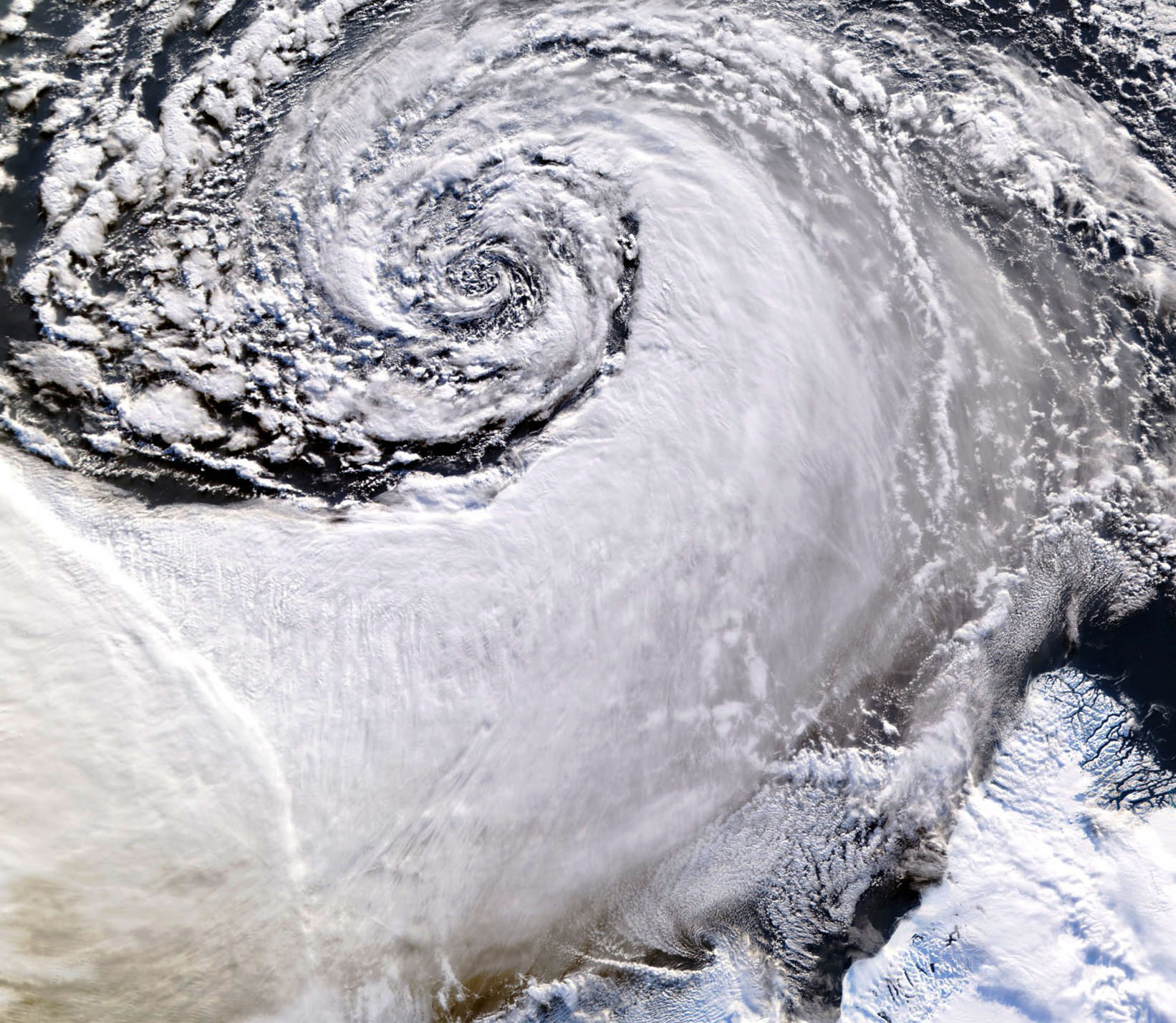
Satellite image of a cloud vortex off the coast of Greenland (NASA/MODIS/Chelys)

Looking south across the southern tip of Greenland, this satellite image shows an enormous cloud vortex spiraling over the northern Atlantic ocean on January 26, 2013. An example of the powerful convection currents in the upper latitudes, these polar low cyclones are created when the motion of cold air is energized by the warmer ocean water beneath.

Sometimes referred to as Arctic cyclones, these spiraling storms can bring gale-force winds and heavy snowfall over a wide area of ocean during their 12- to 36-hour lifespans. Hurricane-type storms don’t only form in the tropics!

This image was captured by the MODIS instrument on NASA’s Aqua satellite from its polar orbit 705 km (438 miles) above the Earth. The view has been rotated so south is up; the southernmost tip of Greenland can be seen at lower right. Click for an impressive high-resolution view.

Image via EOSNAP/Chelys

Continuing the Landsat Mission: New Satellite Launches to Space

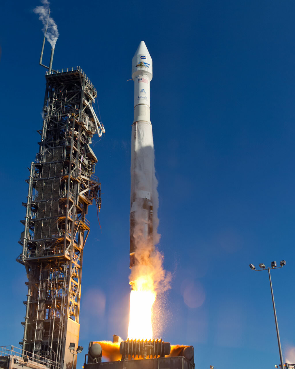
An Atlas-V rocket with the Landsat Data Continuity Mission (LDCM) spacecraft onboard is seen as it launches on Monday, Feb. 11, 2013 at Vandenberg Air Force Base, California. Credit: NASA

NASA launched a successor to the long-time Landsat satellite Earth-observing program today, sending the Landsat Data Continuity Mission satellite to orbit via an Atlas V rocket from Vandenberg Air Force Base at 1:02 EST (10:02 PST, 18:02 UTC). The new LDCM carries two new instruments, the Operational Land Imager and the Thermal Infrared Sensor, which will collect data that are compatible with data from previous Landsat mission, 5 and 7, and improve upon it with advanced instrument designs that are more sensitive to changes to the land surface, NASA said. This is the eighth Landsat satellite, and after extensive on-orbit testing and certified for its mission, it will be renamed Landsat 8.

See the launch video, below:

LDCM will continue the Landsat program’s 40-year data record of monitoring Earth from space, making critical observations to help with energy and water management, forest monitoring, human and environmental health, urban planning, disaster recovery and agriculture.

The new satellite is about the size of a large SUV, weighing 2,780 kg (6,133-pounds). The two instruments will monitor Earth’s surface in visible and multiple infrared wavelengths, resolving large-scale surface features and collecting some 400 images per day. The satellite is equipped with a 3.14-terabyte solid-state recorder to store data between downlink sessions.

“This will be the best Landsat satellite launched to date,” said Jim Irons, LDCM project scientist at Goddard Spaceflight Center, “the best Landsat satellite ever in terms of the quality and quantity of the data collected by the LDCM sensors.”

The United Launch Alliance (ULA) Atlas-V rocket with the Landsat Data Continuity Mission (LDCM) spacecraft onboard is seen as it launches on Monday, Feb. 11, 2013 at Vandenberg Air Force Base, California. Credit: NASA

Irons said the Landsat program is a critical and extremely valuable national asset.

“Since the launch of Landsat 1, we have seen — and we have caused — dramatic changes to the global land surface that continue today at rates unprecedented in human history,” he said. “These changes are due to an increasing population, advancing technologies and climate change. LDCM will extend and improve upon the Landsat record of landscape change. The resulting observations and information will be critical to managing increasing demands on land resources and preparing for inevitable changes to the global land surface.”

Recently, Landsat 5 successfully set the new Guinness World Records title for ‘Longest-operating Earth observation satellite.’ It was launched on March 1, 1984, and outlived its three-year design life. It delivered high-quality, global data of Earth’s land surface for 28 years and 10 months, completing over 150,000 orbits and sending back more than 2.5 million images of Earth’s surface. On Dec. 21, 2012 the USGS announced Landsat 5 would be decommissioned in the coming months after the failure of a redundant gyroscope. The satellite carries three gyroscopes for attitude control and needs two to maintain control.

The Landsat Program is managed by the U.S. Geological Survey (USGS).

Read more about the Landsat Program here.

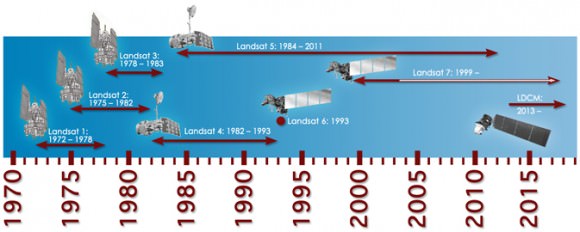
This timeline shows the continuing Landsat Program:

Timeline showing lifespans of the Landsat satellites. Credit: NASA

This video shows the separation of the spacecraft as it prepares to go into orbit: