A Brand New “Blue Marble” View of Earth

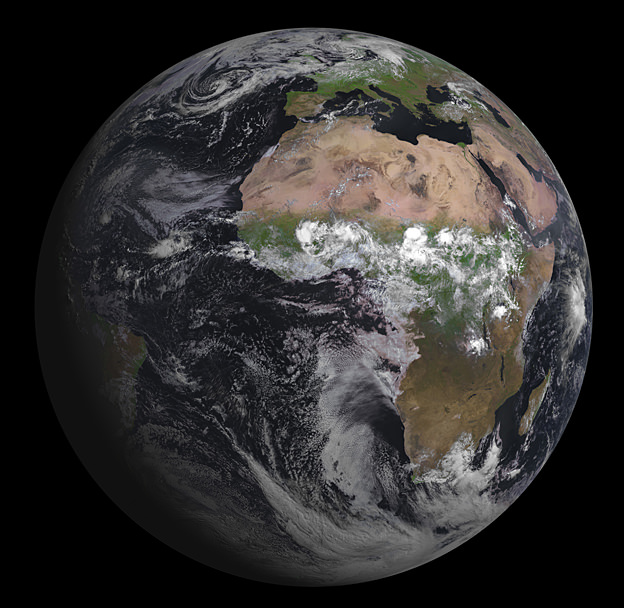
Europe’s latest geostationary weather satellite has captured its first image of Earth, and it’s a beauty! The Spinning Enhanced Visible and Infrared Imager (SEVIRI) instrument on the Meteosat Second Generation-3 (MSG-3) satellite was launched on July 5, 2012, and has since been in the commission stage. ESA says it will still be a couple of months before it is ready for operations.

SEVIRI provides enhanced weather coverage for Europe and Africa in order to improve very short range forecasts, in particular for rapidly developing thunder storms or fog. It scans Earth’s surface and atmosphere every 15 minutes in 12 different wavelengths, to track cloud development. SEVIRI can pick out features as small as a kilometer across in the visible bands, and three kilometers in the infrared.

MSG-3 is the third in a series of four satellites. In addition to its weather-watching mission and collection of climate records, MSG-3 has two secondary payloads.

The Geostationary Earth Radiation Budget sensor measures both the amount of solar energy that is reflected back into space and the infrared energy radiated by the Earth system, to better understand climate processes.

A Search & Rescue transponder will turn the satellite into a relay for distress signals from emergency beacons.

You can see a high resolution version of the image from ESA here.

CINEMA and the Cube-Shaped Future of Space Science

Caption: Jerry Kim, a former student and systems engineer, holds the CINEMA nanosatellite before it was packaged up and sent to NASA in January 2012. Credit: Robert Sanders.

We all will be biting our nails on August 5th as Curiosity makes its perilous descent to the surface of Mars. We have put all our eggs in the biggest, heaviest, most expensive basket, with one of the the most complex science packages and landing procedures. But there is another mission that launches this Friday that likes to keep things small, simple, cheap and accessible!

Scheduled to launch Friday, Aug. 3 from Space Launch Complex-3 at Vandenberg Air Force Base, at 12:27 a.m. PDT CINEMA (CubeSat for Ions, Neutrals, Electrons, & MAgnetic fields) is only one of 11 tiny cubesat satellites that are hitching a lift on an Atlas V rocket alongside the main payload, classified satellite
NROL-36.

ESA included seven Cubesats in the payload for Vega’s maiden flight back in February, but this will be the first time for NASA. Cubesats are modular, cheap, nanosatellites, measuring 10 cm per side, with a maximum mass of 1 kg. CINEMA is comprised of three such cubes, forming a shoebox-sized package weighing 3.15 kg and was developed by students at the University of California, Berkeley, Kyung Hee University in Korea, Imperial College London, Inter-American University of Puerto Rico, and University of Puerto Rico, Mayaguez.

CINEMA is designed to obtain images of the electrical ring current that encircles the Earth and which, during large magnetic storms can knock out our power grids. It carries the STEIN (Suprathermal Electrons, Ions, and Neutrons) Sensor, which will produce an image of the high-energy charged particles in Earth’s atmosphere, mostly ionized hydrogen and oxygen, by detecting energetic neutral atoms (ENAs) As ionized particles spiral around magnetic field lines surrounding Earth, they occasionally hit a neutral particle and grab an electron, transforming into ENAs that travel in a straight line. These can reveal the energy and location of the charged particles from which they came. CINEMA will be joined next year by three identical satellites, two launched by Korea and another by NASA, together they will monitor the 3-dimensional structure of the ring current. Also on board is the MAGIC (MAGnetometer from Imperial College) instrument, provided by Imperial College London, to measure changes in Earth’s magnetic field caused by magnetic storms.

CINEMA is only one of five university-built CubeSats aboard the Atlas V rocket. As they can be bought for only around $1,000 and can then fitted with sensors, transmitters, cameras etc, being able to include multiple satellites in a single launch keeps costs down. Universities can use cubesats to give students hands-on experience of designing, planning, building, running and monitoring a real scientific space mission.

CINEMA principal investigator Robert Lin, professor emeritus of physics and former director of UC Berkeley’s Space Sciences Laboratory, explained some of the pros and cons of cubesats. “There is more risk with these projects, because we use off-the-shelf products, 90 percent of the work is done by students, and the parts are not radiation-hard,” he said. “But it is cheaper and has the latest hardware. I will be very impressed if it lasts more than a year in orbit.”

Additionally, being small means that these satellites pose no threat as space junk either, burning up harmlessly in Earth’s atmosphere when they reach the end of their lifespan.

Find out more about CINEMA at the UC Berkley News Center

Curiosity’s Grand Entrance with Star Trek’s William Shatner and Wil Wheaton – Video Duet

Video Caption: Star Trek’s Captain Kirk, actor William Shatner, guides viewers through the video titled, “Grand Entrance,” showing NASA’s Curiosity Mars Science Lab mission from atmospheroic entry through descent, and after landing on the Red Planet on August 6 2012.

As NASA engineers and scientists make final preparations for the Red Planet landing of NASA’s most difficult planetary science mission to date – the Curiosity Mars Science Lab – inside Gale Crater on the night of August 5/6, Star Trek actors William Shatner and Wil Wheaton lend their voices to a pair of new mission videos titled “Grand Entrance”

The video duet describes the thrilling story of how Curiosity will touch down on Mars and guides viewers through the nail biting “7 Minutes of Terror” – from entry into the Martian atmosphere at over 13,000 MPH and then how the rover must slow down through descent, set down for a soft and safe landing and ultimately how Curiosity will search for signs of life. Continue reading “Curiosity’s Grand Entrance with Star Trek’s William Shatner and Wil Wheaton – Video Duet”

DARPA Moving Ahead with Building Zombie Frankensatellites

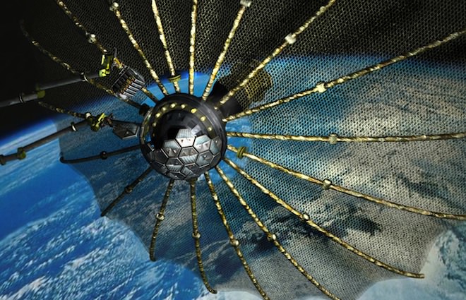
Caption: Phoenix satellite concept. Credit: DARPA

“Alien” meets “Bride of Frankenstein” and “Night of the Living Dead?” Straight from a possible sci-fi/horror movie mashup, the Defense Advanced Research Projects Agency (DARPA) wants to harvest components from dead, non-working “zombie” satellites to build new ones in space, all done remotely via a grasping, mechanical arm.

The agency would like to have the first keystone mission of what is called the Phoenix Program up and running by 2015, and they recently announced that several companies and NASA’s Jet Propulsion Lab have won a share of a $36 million contract award to help develop the technology to assemble new satellites from old, dead ones.

This project would harvest larger working parts, such as antennas and solar arrays from satellites that have otherwise have failed and are still in geosynchronous orbit, 35,000 kilometers (22,000 miles) above Earth. DARPA envisions robotically removing and re-using these parts from decommissioned satellites by developing a new class of very small ‘satlets,’ similar to nano satellites, which could “ride along” other commercial satellite launches, greatly reducing launch costs, DARPA says.

The satlets would attach themselves to the antenna or solar array of a non-functional satellite, remove the part and move it to a different orbit where a satellite servicing spacecraft is waiting to robotically operate on and build a new satellite while in orbit. The servicing satellite would be equipped with grasping mechanical arms for removing the satlets and components. These unique space tools are what needs to be developed for the program.

The robotic arms/grappling tools will be controlled remotely from Earth. The pieces will then be reconfigured into a new free-flying space system and operated independently to demonstrate the concept of space re-use.

DARPA is interested in building communication satellites to provide 24-hour communication capabilities for the military.

“Today, when a communication satellite fails, it usually means the expensive prospect of having to launch a brand new replacement communication satellite,” DARPA’s Phoenix Program webpage says. “The goal of the Phoenix program is to develop and demonstrate technologies to cooperatively harvest and re-use valuable components from retired, nonworking satellites in GEO and demonstrate the ability to create new space systems at greatly reduced cost.”

Among the companies that have a share in creating the components needed to make Phoenix a reality are Altius Space Machines, Space Systems/Loral; Intelsat; MacDonald, Dettwiler and Associates; Honeybee Robotics; and JPL.

Some of the technology DARPA expects to be built for the Phoenix program include:

Radiation tolerant micro-electronics and memory storage
Industrial robotics end effectors and tool changeout mechanisms and techniques
Computer-assisted medical robotics micro-surgical tele-presence, tools and imaging
Remote imaging/vision technologies

Watch DARPA’s video on the Phoenix Program:

For more information, see the DARPA Phoenix webpage.

Greenland Glacier Calves Another Huge Ice Island

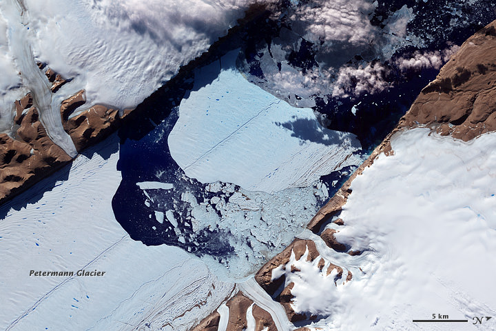
Petermann glacier, a 70 km (43 mile) long tongue of ice that flows into the Arctic Ocean in northwest Greenland, recently calved an “ice island” approximately 130 square kilometers (50 sq. miles) — about twice the area of Manhattan. The image above, acquired by NASA’s Terra satellite, shows the ice island as it drifts toward the ocean five days after breaking off the main glacier.

Petermann glacier has been known for birthing massive ice islands; previously in August 2010 an even larger island broke away from the glacier, measuring 251 square kilometers (97 sq. miles). That slab of ice eventually drifted into the northern Atlantic and was even visible from the Space Station a year later!

Read: Manhattan-Sized Ice Island Seen From Space

Although some of Greenland’s glaciers have been observed to be quickening their seaward pace as a result of global warming, this particular calving event — which occurred along a crack that appeared in 2001 satellite imagery — isn’t thought to be a direct result of climate but rather of ocean currents and isn’t expected to have any significant effect on the rate of Greenland’s ice loss as a whole. Still, satellite observation of such events provides valuable data for researchers monitoring the processes that are involved with rapidly accelerating Arctic ice loss.

And if you want an idea of what a slab of ice this large looks like up close, here’s a video taken by researchers on approach to a smaller chunk of the 2011 island:

NASA Earth Observatory image by Jesse Allen, using data from NASA/GSFC/METI/ERSDAC/JAROS, and U.S./Japan ASTER Science Team. (NASA/Terra)

The Top 5 “Earth as Art” Images, Thanks to Landsat

NASA’s first Earth-observing Landsat satellite launched from Vandenberg Air Force Base on July 23, 1972, and to celebrate the 40th anniversary of the program they asked the public to vote on their favorite images of the planet from the Landsat Earth as Art gallery. After over 14,000 votes, these were chosen as the top 5 favorites. Happy 40th anniversary, Landsat!

Landsat images from space are not merely pictures. They contain many layers of data collected at different points along the visible and invisible light spectrum. A single Landsat scene taken from 400 miles above Earth can accurately detail the condition of hundreds of thousands of acres of grassland, agricultural crops or forests.

“Landsat has given us a critical perspective on our planet over the long term and will continue to help us understand the big picture of Earth and its changes from space,” said NASA Administrator Charles Bolden. “With this view we are better prepared to take action on the ground and be better stewards of our home.”

In cooperation with the U.S. Geological Survey (USGS), a science agency of the Interior Department, NASA launched six of the seven Landsat satellites. The resulting archive of Earth observations forms a comprehensive record of human and natural land changes.

“The first 40 years of the Landsat program have delivered the most consistent and reliable record of Earth’s changing landscape.”

– Michael Freilich, director of NASA’s Earth Science Division

“Over four decades, data from the Landsat series of satellites have become a vital reference worldwide for advancing our understanding of the science of the land,” said Interior Department Secretary Ken Salazar. “The 40-year Landsat archive forms an indelible and objective register of America’s natural heritage and thus it has become part of this department’s legacy to the American people.”

The next satellite in the series, the Landsat Data Continuity Mission (LDCM) is scheduled to launch on February 11, 2013.

(Source: NASA/GSFC)

Find out more about the ongoing Landsat mission here, and see recent visualizations from Landsat on the USGS site here.

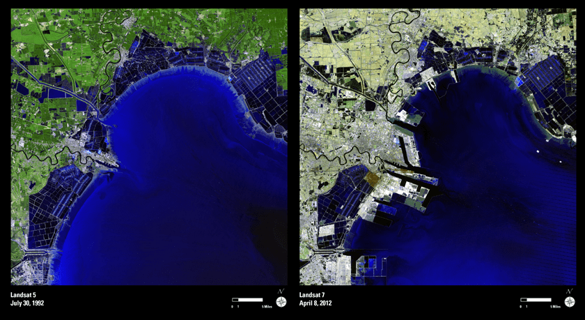
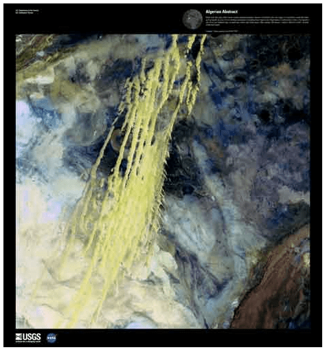
Video: NASA/GSFC. Inset image: Industrial growth in Binhai New Area, China.  Sub-feature: Erg Iguidi, an area of ever-shifting sand dunes extending from Algeria into Mauritania in northwestern Africa, one of the chosen top 5 Earth as Art images. NASA/GSFC/USGS.

Virgin Galactic Announces New Satellite Launcher

Caption: Richard Branson at the Farnborough International Airshow showing a model of LauncherOne. Credit: Virgin Galactic.

Virgin Galactic’s latest venture is launching small satellites with a new, more affordable launching system called LauncherOne. “The pieces are all in place to transform the business of satellite launch, which will open up space to everyone,” said the founder of Virgin Galactic, Richard Branson. “This new vehicle will change the whole satellite industry and space-based science research.”

LauncherOne is much like the Pegasus system, operated by Orbital Sciences Corporation, which launches a rocket from an aircraft, as was done with NASA’s NuSTAR X-ray observatory. LauncherOne will be attached to the WhiteKnight plane, the mothership for SpaceShipTwo, Virgin’s commercial suborbital passenger ship.
LauncherOne could be used for smaller Earth observation and communications satellites.

Virgin Galactic has hinted previously that they were working on a rocket to put spacecraft into orbit, but they have been focusing on SpaceShipTwo. Branson announced the new launcher at the Farnborough International Airshow in the UK today.

“Small satellite launch is an area ripe for disruption,” said Virgin Galactic CEO George Whitesides. “Miniaturized satellite components and constrained budgets are driving commercial clients, academic users and government agencies all to clamor for an affordable, dedicated launch vehicle. Now,…we’re prepared to fill that void by bringing LauncherOne to market.”

Initial information about LauncherOne is that it would use a two-stage rocket powered by liquid oxygen and kerosene.

It would be capable of launching payloads of up 225kg (500lb) into low-Earth orbits, and for a price below $10 million.

“The cost of putting a satellite into space before Virgin Galactic was around $30-40 million,” Branson said. “We’ll be able to do it for under $10 million, opening up space to thousands of new groups, universities and research programs.”

LauncherOne will be built in California, with test flights starting in 2015 and commercial operations starting in 2016.

“Virgin Galactic’s goal is to revolutionize the way we get to space,” Branson said. “I’m immensely proud of what we have already achieved as we draw near to regular suborbital flights on SpaceShipTwo. Now, LauncherOne is bringing the price of satellite launch into the realm of affordability for innovators everywhere, from start-ups and schools to established companies and national space agencies. It will be a critical new tool for the global research community, enabling us all to learn about our home planet more quickly and affordably.”

Branson said he already has people lined up to book the new launcher. “Even before this official launch we have the largest order book of any new launch vehicle ever,” he said on the Virgin blog.

Sources: Virgin, BBC

Powerful “Derecho” Storms as Seen from Space

The powerful windstorms that swept across the US last week was captured by several different satellites. This type of storm, called a derecho, moved from Illinois to the Mid-Atlantic states on June 29, and the movie from NOAA’s GOES-13 satellite shows the storms’ sudden expansion and speed. The storms left a more than 1,000-km (700-mile) trail of destruction across the Midwest and mid-Atlantic, cutting power to millions and killing thirteen people.

A derecho (pronounced “deh-REY-cho”) is not your average, ordinary local summer thunderstorm. These are widespread, long-lived but rare wind storms that are usually associated with a band of rapidly moving showers or thunderstorms. Damage from a derecho is usually in one direction along a relatively straight track. By definition an event is classified a derecho if the wind damage swath extends more than 400 km (240 miles) and includes wind gusts of at least 93 km/h (58 mph) or greater along most of its length.

These storms occur in the United States during the late spring and summer, with more than three quarters occurring between April and August.

The movie begins on June 28 at 15:15 UTC (11:15 a.m. EDT) and ends on June 30, 2012 at 16:01 UTC (12:01 p.m. EDT). In the animation, the derecho’s clouds appear as a line in the upper Midwest on June 29 at 14:32. By 16:02 UTC, they appear as a rounded area south of Lake Michigan. By 21:32, the area of the derecho’s clouds were near Lake Erie and over Ohio expanding as the system track southeast. By 06:30 UTC, the size appears to have almost doubled as the derecho moves over West Virginia, Maryland, Pennsylvania and Virginia. At 02:32 UTC on June 30 (10:32 p.m. EDT), the Derecho was over the mid-Atlantic bringing a 160 km (100 mile) line of severe storms and wind gusts as high as 144 km/h (90 mph) to the region.

“It is interesting how the process is a self-sustaining process that is fed by a combination of atmospheric factors that all have to be in place at the same time,” said Joe Witte, a meteorologist in Climate Change Communication at George Mason University, Va. and a consultant to NASA. “That is why they are relatively rare: not all the elements line up that often.”

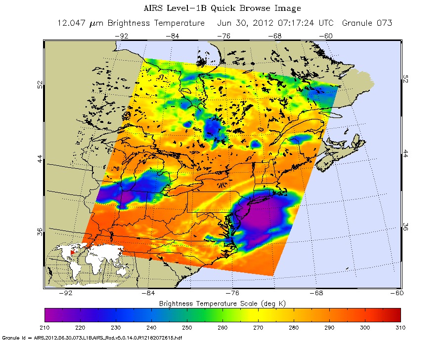
NASA’s Aqua satellite flew over the derecho on June 29 and June 30, using the Atmospheric Infrared Sounder instrument (AIRS) onboard to capture infrared imagery of the event, as seen above.

“The AIRS infrared image shows the high near-surface atmospheric temperatures blanketing the South and Midwestern U.S., approaching 98 degrees Fahrenheit,” said Ed Olsen of the AIRS Team at NASA’s Jet Propulsion Laboratory.

The AIRS images for June 30 show areas of intense convection centered off the New Jersey coast and another, less intense, system over Iowa-Indiana-Ohio. The area off the New Jersey coast is no longer a rapidly moving linear front. The near-surface atmospheric temperatures over the South and Midwest had decreased by 10 to 15 Fahrenheit in most areas,” Olsen said.

NASA’s Suomi National Polar-orbiting Partnership satellite (NPP) captured night-time images on June 28 and June 30, that reflected the massive blackouts that occurred after the derecho swept through the mid-Atlantic states. You can see the comparison images here at NASA’s Earth Observatory website.

The mechanics of a derecho go like this: The downburst mentioned by Witte, above, occurs when cold air in the upper atmosphere is cooled more by the evaporation of some of the rain and melting of the frozen precipitation pushed up into the high levels of the towering cumulonimbus (thunderclouds). That cold air becomes much denser than the surrounding air and literally falls to the ground, accelerating like any other falling body.

“The huge blob of very cold air from the upper atmosphere has a higher forward wind speed since it is high in the atmosphere,” Witte said. “This gives the ‘blob’ great forward momentum. Add that speed to the falling speed and the result is a very powerful forward moving surface wind.”

The process of a derecho can become self-sustaining as hot and humid air is forced upward by the gust front and develops more (reinforcing) towering clouds. If there is a rear low level jet stream, there is nothing to stop the repeating process.

You can find out more information about derechos at this NOAA page.

Source: NASA

Super Secret Spy Satellite Soars Spectacularly to Space on Delta 4 Heavy Booster

Image caption: An upgraded Delta 4 Heavy rocket and super secret spy satellite roar off pad 37 on June 29, 2012 from Cape Canaveral, Florida. Credit: Ken Kremer

A super secret spy satellite for the National Reconnaissance Office (NRO) soared spectacularly to space today (June 29) aboard a Delta 4 Heavy Booster – America’s most powerful rocket following the retirement of NASA’s venerable Space Shuttle Orbiters.

Liftoff of the mammoth Delta 4 Heavy rocket – composed of a trio of liquid fueled common core boosters – finally came at 9:15 a.m. EDT about 3 hours late after a variety of technical issues halted the countdown three times at less than 4 minutes from liftoff from Space Launch Complex 37 on Cape Canaveral Air Force Station, Florida.

Heavy rains and flooding from Tropical Storm Debby had forced a 1 day launch delay from June 28.

The 232 foot tall United Launch Alliance (ULA) Delta lifted off into a magnificent clear blue sky atop the rumbling thunder of three upgraded boosters strapped together side by side and it gradually arced over to the East on the way to orbit.

Both side attached boosters jettisoned as planned. After the second stage engine ignited and the payload fairing separated, the flight went into a preplanned communications black out for the remainder of the flight to orbit and the entire intelligence mission ahead for the hush, hush NROL-15 satellite.

“Today’s successful launch of the NROL-15 mission is the third of four launches for the NRO this year and the second EELV launch for the NRO in just nine days,” said Jim Sponnick, ULA vice president, Mission Operations. “We congratulate the combined NRO , U.S. Air Force and ULA team along with our mission partners for their continued focus on mission success as we deliver the critical capabilities to support the soldiers, sailors, airmen and Marines.”

Just last week on June 20, a ULA Atlas 5 booster lofted the secret NROL-38 satellite for the NRO.

This was only the 6th launch of the Delta 4 Heavy booster and the inaugural flight featuring the upgraded RS-68A Liquid Hydrogen/Liquid Oxygen first stage engines. Each improved engine delivers some 797,000 pounds of thrust vs 758,000 pounds in the prior version – an increase of 39,000 pounds. A single RL 10 engine powered the second stage.

“The upgraded Delta IV Heavy vehicle was developed with an extremely thorough and comprehensive system engineering process by the ULA and Pratt-Whitney Rocketdyne teams, along with substantial involvement by our U.S. government customers,” said Sponnick. “Congratulations to the entire team on today’s successful inaugural flight of the upgraded Delta IV Heavy launch vehicle and the RS-68A engine.”

Ken Kremer

Pacific Glory

An optical phenomenon known as a “glory” is seen over a cloud-covered Pacific Ocean in this image from NASA’s Aqua satellite, acquired on June 20, 2012. Although the colors may make it look like a rainbow, the process behind its formation is somewhat different.

As vortices spiral off the leeward side of Guadalupe Island, off the western coast of Baja California, a shimmering spectrum of colors highlights a glory just west of the island. Glories are created when light from the Sun reflects back toward an observer off water droplets within clouds or fog. They are often seen from airplanes as a bright ring of light encircling a silhouetted shadow of the aircraft below, but are also visible from the ground and, sometimes, even from space.

From the NASA Earth Observatory website:

Although glories may look similar to rainbows, the way light is scattered to produce them is different. Rainbows are formed by refraction and reflection; glories are formed by backward diffraction. The most vivid glories form when an observer looks down on thin clouds with droplets that are between 10 and 30 microns in diameter. The brightest and most colorful glories also form when droplets are roughly the same size.

From the ground or an airplane, glories appear as circular rings of color. The space shuttle Columbia observed a circular glory from space in 2003. In the image above, however, the glory does not appear circular. That’s because MODIS scans the Earth’s surface in swaths perpendicular to the path followed by the satellite. And since the swaths show horizontal cross sections through the rings of the glory, the glory here appears as two elongated bands of color that run parallel to the path of the satellite, rather than a full circle.

Glories always appear around the spot directly opposite the Sun, from the perspective of the viewer. This spot is called the anti-solar point. To visualize this, imagine a line connecting the Sun, a viewer, and the spot where the glory appears. In this case, the anti-solar point falls about halfway between the two colored lines of the glory.

Click here to download the full-size image.

NASA image courtesy Jeff Schmaltz, LANCE MODIS Rapid Response. Read more here.