UARS Update: NASA Refines Crashing Satellite’s Debris Region and Location

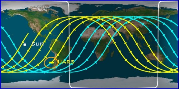
This video from Analytical Graphics, Inc. shows an updated animated analysis of the break-up of the the 6-ton, bus-sized UARS satellite. It likely will burn up at an altitude between 80-45 kilometers, with an estimated 26 pieces of debris re-entering the atmosphere for land fall or splash down. The debris zone is predicted to be about 500 miles long.

The latest update put out by NASA on the Upper Atmosphere Research Satellite (UARS) is that as of 1:30 p.m. EDT Sept. 21, 2011, (17:30 GMT) the orbit of UARS was 120 mi by 130 mi (190 km by 205 km). Re-entry is expected sometime during the afternoon of Sept. 23, Eastern Daylight Time. NASA says the satellite will not be passing over North America during that time period, but that it is still too early to predict the time and location of re-entry with any more certainty. They will be able to further refine more details in the next 24 to 48 hours.

AGI has created an app for Android phones where you can track the UARS orbit track. See this link for more info.

Sources: NASA, AGI

Must See Video: Falling NASA UARS Satellite Observed While Still in Orbit

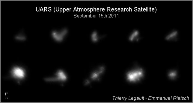
Several views of the UARS satellite in orbit, as seen from the ground with a 14" telescope. Credit: Thierry Legault Emmanual Rietsch

The huge Upper Atmosphere Research Satellite (UARS) will be plummeting to Earth in an uncontrolled re-entry this week, but here’s an incredible video from astrophotographer extraordinaire Thierry Legault who shot footage of UARS with his 14-inch telescope. Legault was in Northern France (Dunkerque) last week to attempt to capture views of the satellite, and had success on September 15, 2011 between 04:42:14 and 04:44:02 UTC, just 8-9 days before its atmospheric reentry, when it was at an altitude of only 250 km. The tumbling, uncontrolled nature of the satellite is obvious in this video, and various components are visible, such as the body itself and the solar arrays.

NASA has now refined its prediction for when this bus-sized satellite will fall to Earth. The 20-year-old defunct satellite now has a predicted re-entry Time of about 20:36 UTC on September 23, 2011, plus or minus 20 hours, according the the UARS Reentry Twitter feed. So, heads up!

[/caption]

This is a day earlier than previously anticipated. Pieces of the 6.5-ton satellite are expected to survive the fiery plunge and hit our planet, but NASA does not know exactly where. There was word today that increased activity from the Sun has hastened the decay of the satellite’s orbit.

Legault said his images show the satellite at a 316 km distance to the observer. The angular speed at culmination: 1.36°/s. The speed of the sequence is accelerated two times with regard to real time (20 fps vs 10 fps). The satellite is tumbling, perhaps because of a collision with satellite debris a few years ago.

Here is the equipment Legault used: Celestron EdgeHD 14” Schmidt-Cassegrain telescope (at a focal length of 8500mm) on automatic tracking system, as described on this page. Camera: Lumenera Skynyx L2-2.

Thanks to Legault for sharing his video and images with Universe Today! See more info at Legault’s website.

Map of the UARS orbital path. Credit: @UARS_Reentry Twitter feed.

NASA says there are about 26 components that are big enough to survive and make it down to Earth, the largest weighing more than 150 kg (330 pounds.)

What are you chances of getting hit by debris? Nick Johnson, chief scientist with NASA’s Orbital Debris Program, said that numerically, it comes out to a chance of 1 in 3,200 that any one person anywhere in the world might be struck by a piece of debris. That might sound high, but if you factor in that there are 7 billion people on Earth and that a large part of Earth is covered by water, the liklihood is actually very small. The chance that any one person on Earth getting hit by debris has been estimated at about 1 in 21 trillion.

We’ll provide more updates on the UARS story. For those who would like to catch a last glimpse of UARS streaking across the night sky for yourself should check Heaven’s Above or SpaceWeather’s Satellite Tracker for flyby times in your area.

For more information about this satellite’s uncontrolled re-entry, see our earlier article detailing UARS.

Book Review: A Dictionary of the Space Age

A Dictionary of the Space Age covers most aspects of space flight but is somewhat lacking in detail. Image Credit: John Hopkins University & Alan Walters/awaltersphoto.com

[/caption]
Writing a dictionary is not the same as writing a novel. While it might seem difficult to mess up a dictionary, even one with terminology that is as complicated as that used within the space industry – getting it right can be challenging. For those that follow space flight having such a dictionary can be invaluable. While A Dictionary of the Space Age does meet the basic requirements easily it fails somewhat in terms of its comprehensiveness.

When normal folks, even space enthusiasts watch launches and other space-related events (EVAs, dockings, landings and such) there are so many acronyms and jargon thrown about – that it is extremely hard to follow. With A Dictionary of the Space Age on hand, one can simply thumb through and find out exactly what is being said, making it both easier to follow along and making the endeavor being witnessed far more inclusive. That is as long if you are only looking for the most general of terms. The book is far from complete – but given the complex nature of the topic – this might not have been possible.

Crewed, unmanned, military space efforts and satellites – all have key terms addressed within the pages of this book.

The book is published by The Johns Hopkins University Press and was compiled and written by aerospace expert Paul Dickson. One can purchase the book on the secondary market (Amazon.com) for around $12 (new for around $25). The dictionary also has a Kindle edition which is available for $37.76. Dickson’s previous works on space flight is Sputnik: The Shock of the Century.

Weighing in at 288 pages, the book briefly covers the primary terms used within the space community. In short, if you are interested in learning more about space flight – or wish to do so – this is a good book for you.

Look Out Below! Huge Satellite Coming in for Uncontrolled Re-Entry

Artist concept of the UARS satellite. Credit: NASA

[/caption]

There’s a defunct 6.5-ton satellite heading our way. Trouble is, NASA’s not sure exactly where and when it might come down. And they’re not sure how much of it might survive its fiery fall through Earth’s atmosphere, either.

“Numerically, it comes out to a chance of 1-in-3,200 that one person anywhere in the world might be struck by a piece of debris,” said Nick Johnson, chief scientist with NASA’s Orbital Debris Program, during a media teleconference on Friday. “Those are obviously very, very low odds that anybody’s going to be impacted by this debris.”

Johnson reminded everyone that “throughout the entire 54 years of the space age, there have been no reports of anybody in the world being injured or severely impacted by any re-entering debris.”

How do you like your odds?

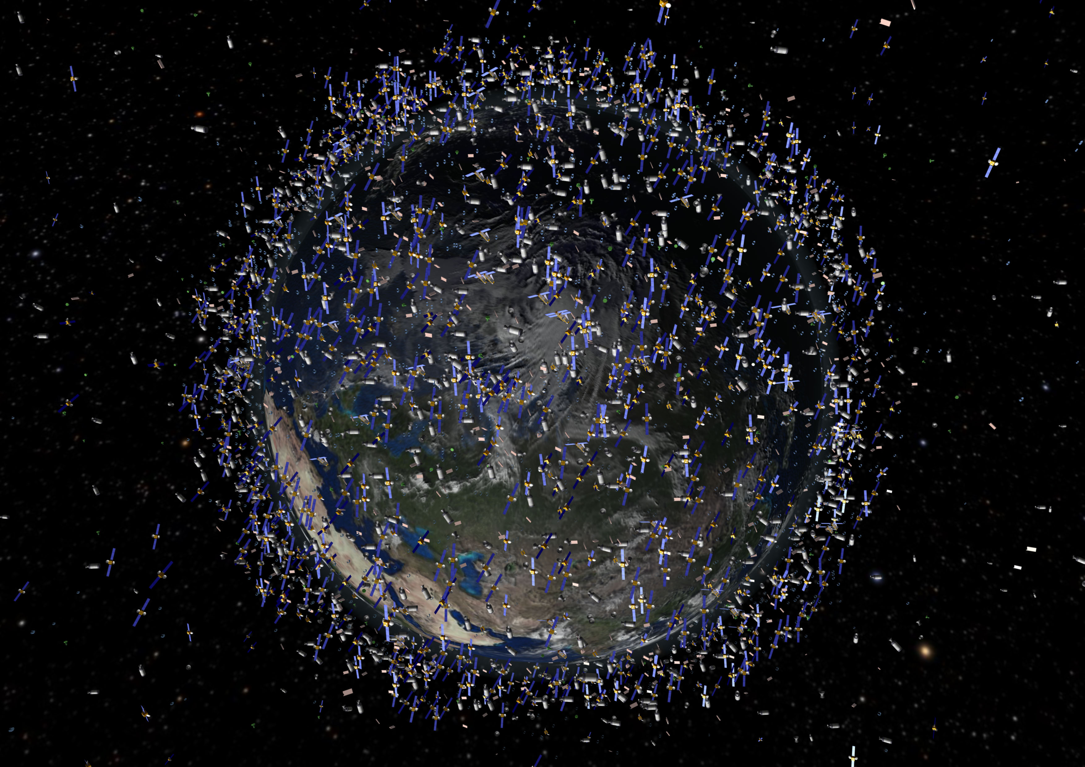
The huge 10-meter (35-ft) -long Upper Atmosphere Research Satellite (UARS) is in an orbit that crosses over six continents and three oceans. Johnson said it is expected to re-enter Earth’s atmosphere in an uncontrolled fall in late September or early October. While much of the spacecraft is expected to burn up during re-entry, it’s likely some pieces will make it to the ground. Current projections on where debris field might be is a 800-km- (500-mile) wide swath from Northern Canada to Southern South America.

Yikes.

Or it might fall in the ocean.

“We do know with 99.9 percent accuracy that it will re-enter the atmosphere somewhere between 57 degrees north and 57 degrees south, which means it will be anywhere from northern Canada to southern South America,” said Major Michael Duncan, deputy chief of space situational awareness with the Air Force’s U.S. Strategic Command. “That is truly the best estimation we can give you at this point in time.”

There are about 26 components that are big enough to survive and make it down to Earth, the largest weighing more than 150 kg (330 pounds.)

But hey, this happens all the time.

“Satellites re-entering is actually very commonplace,” Johnson said. “Last year, for example, we averaged over one object per day falling back uncontrolled into the atmosphere,” and for those coming back in an uncontrolled fashion – meaning it is a crapshoot when and where they fall — there were 75 metric tons of spacecraft and rocket bodies falling back to Earth.

“In perspective, UARS is less than six metric tons,” Johnson added. “So it’s a very small percentage of the annual re-entry of satellites.”

The majority of these satellites, though, were a lot smaller than UARS and they burn up completely in the atmosphere.

The UARS satellite launched from Space Shuttle Discovery in 1991. To give you an idea of how big the satellite is, it filled the shuttle’s payload bay completely. It had ten science instruments to examine the chemistry of the upper atmosphere and measure water vapor and other elements. It monitored the health of the ozone hole, looking at the amounts of aerosols in the atmosphere. In 2005 NASA determined that UARS was to be decommissioned.

It was never designed to be returned on the Space Shuttle, said Paul Hertz, chief scientist, NASA’s Science Mission Directorate.
Hertz said NASA is trying to keep the public informed about the the possibilities of debris failing and want to be up front about it. They will post all current information on www.nasa.gov/uars.

And Space Command will be tracking the satellite and providing updates as to where and when UARS will come down, and provide impact predictions if it looks like it will be coming down over land.

Although there are no hazardous materials on board – unlike the hydrazine on a National Reconnaissance Office spy satellite that was shot down in 2008 to avoid contaminating Earth – it was stressed that if anyone finds a piece of the satellite, they should not pick it up, but notify the local authorities.

But anyone along the final trajectory should get “a nice show,” Johnson said.

“It is a relatively large vehicle,” he said. “It would be visible in daylight. Odds are, though, it’s going to happen over an ocean, unlikely to be seen unless it’s by an airliner. We’ve had reports like that before. Since we don’t know where it’s going to come in, we can’t raise people’s expectations and tell them to go out and look in their backyard. So it’ll be a serendipitous kind of event.”

James Webb Space Telescope Nearing Completion

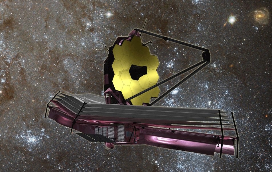
The James Webb Space Telescope. Image Credit: NASA/JPL

[/caption]
The James Webb Space Telescope or JWST has long been touted as the replacement for the Hubble Space Telescope. The telescope is considered to be the one of the most ambitious space science projects ever undertaken – this complexity may be its downfall. Cost overruns now threaten the project with cancellation. Despite these challenges, the telescope is getting closer to completion. As it stands now, the telescope has served as a technical classroom on the intricacies involved with such a complex project. It has also served to develop new technologies that are used by average citizens in their daily lives.

Although compared to Hubble, the two telescopes are dissimilar in a number of ways. The JWST is three times as powerful as Hubble in its infrared capabilities. JWST’s primary mirror is 21.3 feet across (this provides about seven times the amount of collecting power that Hubble currently employs).

The JWST’s mirrors were polished using computer modeling guides that allowed engineers to predict that they will enter into the proper alignment when in space. Each of the mirrors on the JWST has been smoothed down to within 1/1000th the thickness of a human hair. The JWST traveled to points across the country to assemble and test the JWST’s various components.

Eventually the mirrors were then sent to NASA’s Marshall Space Flight Center in Huntsville, Alabama. Once there they measured how the mirrors reacted at extremely cold temperatures. With these tests complete, the mirrors were given a thin layer of gold. Gold is very efficient when it comes to reflecting light in the infrared spectrum toward the JWST’s sensors.

A comparison of the primary mirror used by Hubble and the primary mirror array used by the James Webb Space Telescope. Photo Credit: NASA

The telescope’s array of mirrors is comprised of beryllium, which produces a lightweight and more stable form of glass. The JWST requires lightweight yet strong mirrors so that they can retain their shape in the extreme environment of space. These mirrors have to be able to function perfectly in temperatures reaching minus 370 degrees Fahrenheit.

After all of this is done, still more tests await the telescope. It will be placed into the same vacuum chamber that tested the Apollo spacecraft before they were sent on their historic mission’s to the moon. This will ensure that the telescopes optics will function properly in a vacuum.

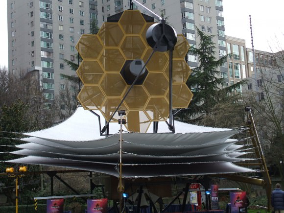
A life-sized model of the JWST was placed on display in Seattle, Washington - it was several stories tall and weighed several tons. Photo Credit: Rob Gutro/ NASA

With all of the effort placed into the JWST – a lot of spinoff technology was developed that saw its way into the lives of the general populace. Several of these – had to be invented prior to the start of the JWST program.

“Ten technologies that are required for JWST to function did not exist when the project was first planned, and all have been successfully achieved. These include both near and mid-infrared detectors with unprecedented sensitivity, the sunshield material, the primary mirror segment assembly, the NIRSpec microshutter array, the MIRI cryo-cooler, and several more,” said the James Webb Space Telescope’s Deputy Project Scientist Jason Kalirai. Kalirai holds a PhD in astrophysics and carries out research for the Space Telescope Science Institute. “The new technologies in JWST have led to many spinoffs, including the production of new electric motors that outperform common gear boxes, design for high precision optical elements for cameras and cell phones, and more accurate measurements of human vision for people about to undergo Laser Refractive Surgery.”

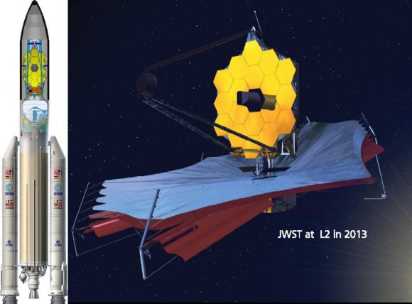
The James Webb Space Telescope encapsulated atop the Ariane V rocket tapped launch it, next to an early image of the telescope. Image Credit: NASA

If all goes according to plan, the James Webb Space Telescope will be launched from French Guiana atop the European Space Agency’s Arianne V Rocket. The rationale behind the Ariane V’s selection was based on capabilities – and economics.

“The Ariane V was chosen as the launch vehicle for JWST at the time because there was no U.S. rocket with the required lift capacity,” Kalirai said. “Even today, the Ariane V is a better tested vehicle. Moreover, the Ariane is provided at no cost by the Europeans while we would have had to pay for a U.S. rocket.”

It still remains to be seen as to whether or not the JWST will even fly. As of July 6 of this year the project is slated to be cancelled by the United States Congress. The James Webb Space Telescope was initially estimated at costing $1.6 billion. As of this writing an estimated $3 billion has been spent on the project and it is has been estimated that the telescope is about three-quarters complete.

Space Debris Problem Getting Worse, New Report Says

Space Debris in polar orbit. Image Credit: ESA

[/caption]

In the movie WALL-E, the Earth is surrounded by a dense field of orbiting junk. The problem of space debris is not that bad yet, but is potentially heading in that direction. A new report released today by the National Research Council says the problem of space debris is getting worse and has passed a “tipping point.” The report says that while NASA has done a good job using their available resources to research the issue, decreased funding and increased responsibilities for the space agency is not a good combination for the future, and NASA has not been able to keep pace with increasing hazards posed by abandoned equipment, spent rocket bodies, and other debris orbiting the Earth.

“The current space environment is growing increasingly hazardous to spacecraft and astronauts,” said Donald Kessler, chair of the committee that wrote the report and retired head of NASA’s Orbital Debris Program Office. “NASA needs to determine the best path forward for tackling the multifaceted problems caused by meteoroids and orbital debris that put human and robotic space operations at risk.”

There’s enough debris currently in orbit to continually collide and create even more debris, raising the risk of spacecraft failures, the report notes. In addition, collisions with debris have disabled and even destroyed satellites in the past, as in the collision in 2009 between an Iridium satellite and a inoperative Russian satellite. Several recent near-misses of the International Space Station requiring evasive maneuvers and sending astronauts to the Soyuz vehicles as a precaution underscores the value in monitoring and tracking orbital debris as precisely as possible.

It is fitting that Kessler lead this committee: he laid out a scenario back in 1978 called the Kessler Syndrome where the amount and size of objects in Earth’s orbit could eventually become so large that they would continually collide with one another and create even more debris, eventually causing a “cascade” of collisions which could make low Earth orbit unusable for decades.

From the new report, it appears the Kessler Syndrome is not just an abstract event that might occur in the future. It’s happening now. The amount of debris is now growing exponentially, as just two collisions since January 2007 has doubled the total number of debris fragments in Earth’s orbit, according to the NRC report.

NASA had asked for the report; specifically, NASA’s chief of safety and mission assurance, Bryan O’Connor, asked the NRC in 2010 to independently examine the agency’s work on debris.

“We thank the National Research Council for their thorough review in this report,” said NASA spokeswoman Beth Dickey. “We will study their findings and recommendations carefully and use them to advise our future actions in this important area of work.”

The report, however, does not provide NASA with many specific ideas but says NASA should develop a formal strategic plan to better allocate its limited resources devoted to the management of orbital debris. In addition, removal of debris from the space environment or other actions to mitigate risks may be necessary.

For example, NASA should initiate a new effort to record, analyze, report, and share data on spacecraft anomalies. This will provide additional knowledge about the risk from debris particulates too small to be cataloged under the current system yet large enough to potentially cause damage.

The report also suggests more work internationally on this problem, since it is a global problem caused by other nations besides the US. Over the past decade and a half, the world’s major space agencies have been developing a set of orbital debris mitigation guidelines aimed at stemming the creation of new space debris and lessening the impact of existing debris on satellites and human spaceflight. Most agencies are in the process of implementing or have already implemented these voluntary measures which include on-board passive measures to eliminate latent sources of energy related to batteries, fuel tanks, propulsion systems and pyrotechnics.

But the growing number of developing countries that are launching using satellites, and they need to be encouraged to use these measures as well.

In addition, NASA should lead public discussion of orbital debris and emphasize that it is a long-term concern for society that must continue to be addressed.

Congress also needs to be aware of the problem and provide adequate funding for the issue.

You can read the report here. (free as a pdf download).

Sources: NRC press release, Washington Post

Latest Satellite Images/Videos as Hurricane Irene Bears Down on US East Coast

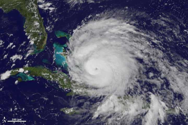
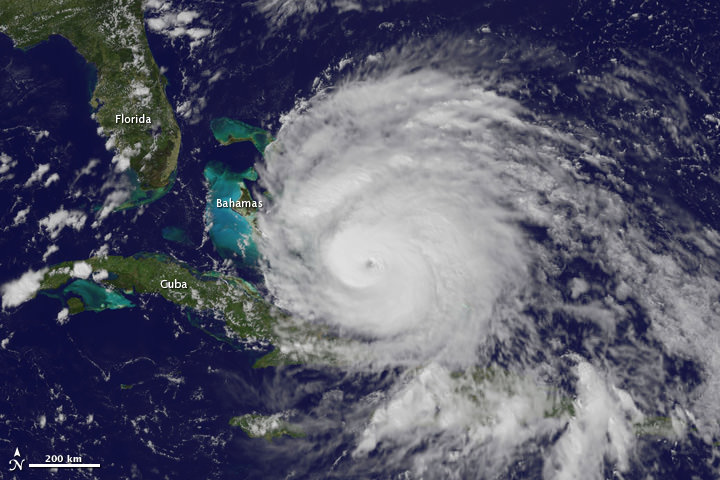
GOES satellite image of Hurricane Irene as of 18:15 UTC on August 26, 2011. Credit: NOAA

What a view: Here’s a video of Hurricane Irene’s path, starting on August 24 up until 18:40 UTC on August 26, 2011, as seen by a GOES satellite. Even though Hurricane Irene is continuing to slowly weaken as it pushes closer to the Carolina coast, this massive storm could affect a huge area of the Eastern US seaboard, and tropical storm force winds and squalls are buffeting the coast. Irene will impact the entire Mid-Atlantic and Northeast Coast, including Washington, Philadelphia, New York City, Hartford, Ct. and Boston this weekend.

This hurricane spans nearly 1,000 kilometers (600 miles).

Below is a video taken from the International Space Station late yesterday afternoon. Includes astronaut commentary on the view of this “huge, scary storm” from 370 km (230 miles) up:

Or click on this link to see the latest video of Hurricane Irene from GOES and Goddard Space Flight Center

Cameras mounted on the International Space Station captured this video. Forecasters are predicting landfall on the outer banks of North Carolina Saturday before tracking up the mid-Atlantic states and a possible path over the metropolitan New York area and New England late this weekend.

[/caption]

Hot off the wires is this satellite image of Hurricane Irene taken less than an hour ago (as of this writing) by one of the GOES satellites for NOAA.

Here’s the latest from WeatherBug:

Imagery of Hurrican Irene from WeatherBug.com

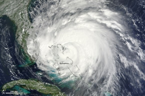
And here’s the latest from the Moderate Resolution Imaging Spectroradiometer (MODIS) on the Terra satellite on August 25:

Hurricane Irene as seen by Moderate Resolution Imaging Spectroradiometer (MODIS) on the Terra satellite on August 25. Credit: NASA

See more up-to-date satellite images from NOAA’s cadre of Earth-observing satellites at this link.

Sources: NASA Earth Observatory, WeatherBug, NOAA, Goddard Space Flight Center

More Views of Hurricane Irene from Space: It’s Big

A view of Hurricane Irene taken by the GOES satellite at 2:55 p.m. Eastern Daylight Time on August 24, 2011. Credit: NASA

Here are several different views of Hurricane Irene: from 230 miles above the Earth, cameras on the International Space Station captured several views of powerful Hurricane Irene as it churned over the Bahamas at 3:10 p.m. EDT on August 24, 2011. Irene is moving to the northwest as a Category 3 hurricane, packing winds of 120 miles an hour. Irene is expected to strengthen to a Category 4 storm as it heads toward the Outer Banks of North Carolina, the Eastern Seaboard and the middle Atlantic and New England states.

See more from other satellites, below:

[/caption]

This view of Irene was taken by the GOES satellite at 2:55 p.m. Eastern Daylight Time on August 24, 2011. Irene now has a distinct eye and the clouds spiraling around the center are becoming more compact. The image also shows how large Irene has become, measuring several hundred kilometers across.

A three dimensional perspective of Irene, showing rainfall. Credit: NASA/TRMM satellite

This image was taken on August 22, but is a really nifty, three-dimensional view of the precipitation from Irene, as seen by the Tropical Rainfall Measuring Mission. It reveals an area of deep convection (shown in red) near the storm’s center where precipitation-sized particles are being carried aloft. These tall towers are associated with strong thunderstorms responsible for the area of intense rain near the center of Irene seen in the previous image. They can be a precursor to strengthening as they indicate areas within a storm where vast amounts of heat are being released. This heating, known as latent heating, is what is drives a storm’s circulation and intensification.

Here’s the latest view of Irene from WeatherBug:

View of Irene from WeatherBug.com

As of 8 a.m. EDT on August 25, Hurricane Irene was located near 25.5 N and 76.5 W, or 65 miles east-southeast of Nassau, Bahamas. This places it about 670 miles south of Cape Hatteras, N.C. Irene`s top sustained winds remain at 115 mph, and is moving to the northwest at 13 mph.

Sources: NASA Multimedia,

Explosive Phytoplankton Bloom Seen From Space

Phytoplankton bloom in the Barents Sea. Credit: NASA/Moderate Resolution Imaging Spectroradiometer (MODIS) on the Aqua satellite

[/caption]

Phytoplankton are tiny, microscopic plant-like organisms, but when they get together and start growing they can cover hundreds of square kilometers and be easily visible in satellite images. This image of the Barents Sea was taken on August 14, 2011 by the Moderate Resolution Imaging Spectroradiometer (MODIS) on the Aqua satellite. When conditions are right, phytoplankton populations can grow explosively, a phenomenon known as a bloom. A bloom may last several weeks, but the life span of any individual phytoplankton is rarely more than a few days. The area in this image is immediately north of the Scandinavian peninsula. Blooms spanning hundreds or even thousands of kilometers occur across the North Atlantic and Arctic Oceans every year. But, said Jeff Schmaltz from NASA’s Earth Observatory website, seeing such a wide area without clouds during the bloom is a rare treat.

Phytoplankton thrive in cold ocean waters, which tend to be rich in nutrients. Schmaltz said the milky blue color is an indicator that the bloom probably contains coccolithophores, which are plated with white calcium carbonate. Seen through ocean water, a coccolithophore bloom is bright blue. Other shades may be from other species of phytoplankton.

Source: NASA’s Earth Observatory website

Chasing Rockets, Chasing History: One Journalist’s Video Reflections

Following the space program is an exhausting business - but one that provides for amazing images and memories. Photo Credit: Jason Rhian

[/caption]
CAPE CANAVERAL Fla. – As one might imagine covering the space program is a exciting vocation. Some professionals focus on writing articles or taking pictures others work with television stations or online media outlets to provide video and commentary. I have selected to attempt to do all of the above. This can be rather challenging. During the final launch of Atlantis for example, I conducted interviews with a variety of guests up until the launch, from there I operated two camcorders and a DSLR camera (for stills).

Doing things this way provides outlets with a wealth of different types of content to choose from. This also means that a lot of material is not used. This article will cover some of the things that ended up on the cutting room floor. What was not used – might surprise you.

SpaceX Surprises

Of the NewSpace organizations that have made their presence known out at Kennedy Space Center – Space Exploration Technologies or SpaceX has had the most significant impact. Lately the firm has worked to get the media out, as much as possible, to see what the company is doing. NASA and many of the established aerospace companies have a hands off approach – essentially you report on what they allow you to report. SpaceX? They allowed this reporter to climb underneath the Falcon 9 and even have it spun on command. Check it out:

Shuttle Memories

Trying to accurately record and report the historic nature of what took place at Kennedy Space Center this summer was challenging. I took every opportunity I could to record what was happening and then relay that to the public. What I will always remember from this time was how open the members of NASA were and how they really tried to work with you to get the story out. To get a taste of what it was like, check out this compilation of shuttle videos from STS-133 through STS-135:

Launches

Whilst following the shuttle, the last two years have been punctuated by a number of awesome unmanned flights as well (not including the launch of the Falcon 9 which you can see above). The second OTV space plane, SBIRS, AEHF-1 and an impressive night launch of a Delta IV Heavy all helped to keep me on the road to Cape Canaveral:

Memorable Interviews

I’ve been privileged to interview many important people within the space community. That however does not mean that their interviews will stick out in my mind. Some of the ones that I remember best are from people that have always been a joy to work with. Stephanie Stilson is one of those people, she always has a kind word and a great quote. Greg Johnson is another, bombastic and easy-going, he has no problem whatsoever veering off of the official NASA script. To separate the two interviews I included a clip of the media being escorted up onto LC39A. Click below to watch:

Experiencing History

It is not every day that one gets to train along with the astronauts. I had the opportunity to do so on STS-135. I flew in the back of the Shuttle Training Aircraft (STA) as Commander Chris Ferguson practiced landing the shuttle. To date, this has to be the high point of my career:

Over the last two years I have been bombarded by folks stating that I should report things “their” way. Some want me to go hyper-technical, so that only an engineer could understand what I was saying. While I’m sure some folks wouldn’t mind breaking out a flight manual to keep up with the jargon – that really isn’t what I’m trying to accomplish. Others tell me to keep it as simple as possible and to never state anything that could be construed as negative – but that doesn’t reflect reality. I try to come in somewhere in the middle. The public should know that this is a highly technical endeavor – but they should also know that it is exciting, that this tale is not one without issues and that I try to show it all, the good, the bad and the awesome.