Launch of Delta IV Delayed; Shuttle Launch Options Weighed

Rocket Science
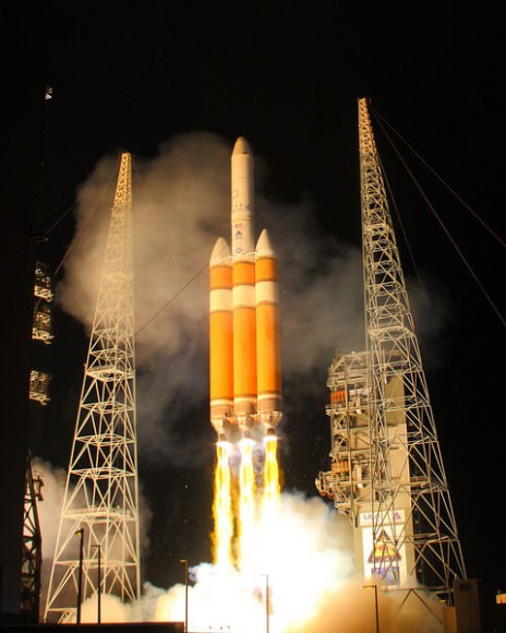
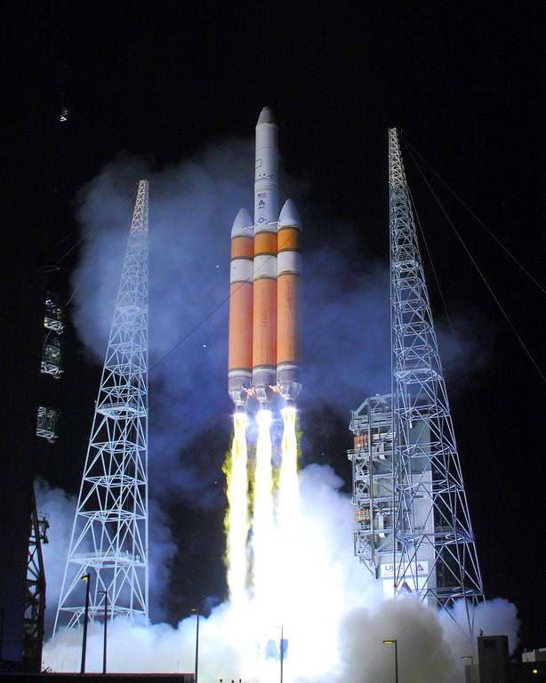
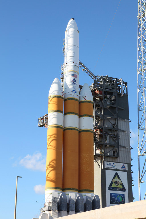
The Delta IV rocket now scheduled for launch on Nov. 21, 2010. Credit: Alan Walters (awaltersphoto.com) for Universe Today

[/caption]

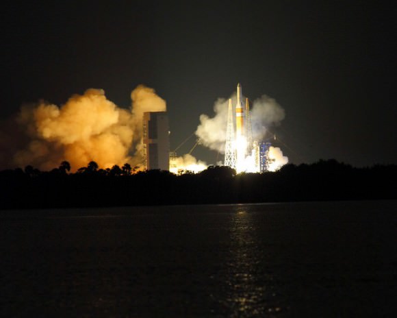
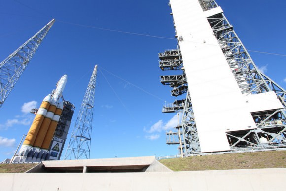
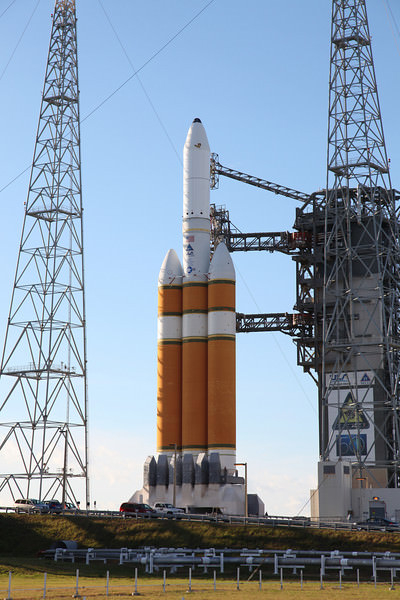
Those waiting for a launch from Florida’s Space Coast will have to wait a little more. The liftoff of a United Launch Alliance (ULA) Delta IV Heavy rocket has been pushed back yet again, and is now scheduled for Sunday, Nov. 21 at 5:58 p.m. EST (2258 GMT) from Space Launch Complex 37 (SLC 37) at Cape Canaveral Air Force Station. The rocket will carry a National Reconnaissance Office payload.

Launch Complex 37 at Cape Canaveral Air Force Station. Credit: Alan Walters (awaltersphoto.com) for Universe Today.

Delayed from the 18th, the next countdown started on Friday, but this too was not to be. As technicians started to fuel up the rocket’s twin strap on boosters encountered temperature anomalies. Engineers did not want to give an estimate as to when the rocket will be ready for launch – until they had a chance to unload the fuel and give the vehicle a closer look.

The Delta IV with a NRO payload. Photo Credit: Universe Today/Alan Walters - awaltersphoto.com

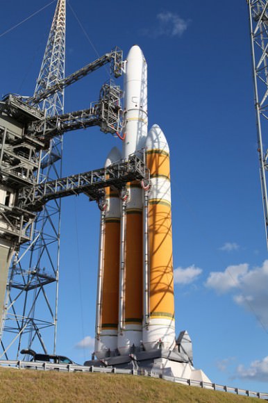
The payload for this mission is a classified spy satellite. In media advisories released by the 45th Space Wing it is described only as a ‘Galaxy 3.’ The 45th is stationed out of Patrick Air Force Base. The Delta IV Heavy is the largest rocket in the Delta 4 family, with three booster cores combined to form what is essentially a triple-bodied rocket.

As far as space shuttle Discovery, NASA managers are still keeping all their options open. Inspectors this week found a fourth crack in support beams on the external fuel tanks of the space shuttle. The work to repair the cracks is ongoing, but the teams will need to complete an engineering review and develop the necessary flight rationale in order to launch with a damaged tank. On Thursday, NASA announced that the flight will launch no earlier than Dec. 3, four days after the opening of a short end-of-year launch window.

The window closes Dec. 6. If NASA cannot get Discovery off the ground in the next available launch window, there is only one other planned launch at KSC/CCAFS for this year. This is the Dec. 7 launch of SpaceX’s Falcon-9 with its Dragon spacecraft payload. If this launch happens before the end of this year, it will mark the first demonstration flight of the $1.6 billion Commercial Orbital Transportation Services contract that the private space firm has with the space agency.

Photo Credit: Universe Today/Alan Walters - awaltersphoto.com

Mount Merapi Still Blowing off Steam

Merapi Volcano on November 10, 2010, when the Moderate Resolution Imaging Spectroradiometer (MODIS) on NASA’s Terra satellite. Credit: NASA

[/caption]

For about three weeks, Indonesia’s Mount Merapi has been belching out lava, as well as ash and gas, clouding the atmosphere above. This satellite image, taken by NASA’s MODIS instrument on the Terra satellite, shows the volcano now settling down and is the most cloud-free satellite view of the volcano that we’ve been able to see. Thick ash is still rising and the volcano is still considered to be erupting at dangerous levels. Merapi is one of Indonesia’s most active volcanoes, and this eruption has been the most violent since the 1870’s.

The dark brown streak down the southern face of the volcano is ash and other volcanic material deposited by a pyroclastic flow or lahar. The volcano has been blamed for 156 deaths and about 200,000 people had to evacuate. The ash also caused flights to be delayed or canceled.

See below for a thermal image of the lava flow.

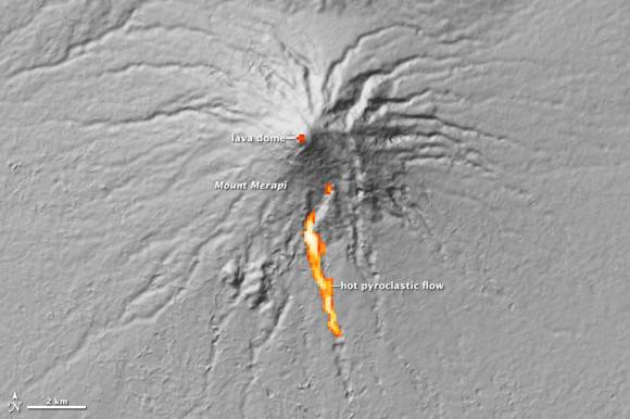
The Advanced Spaceborne Thermal Emission and Reflection Radiometer (ASTER) on NASA’s Terra satellite captured the thermal signature of hot ash and rock and a glowing lava dome on Mount Merapi on Nov. 1, 2010. Credit: NASA.

As a very active volcano, Merapi poses a constant threat to thousands of people in Indonesia. The Advanced Spaceborne Thermal Emission and Reflection Radiometer (ASTER) on NASA’s Terra satellite captured the thermal signature of hot ash and rock and a glowing lava dome. The thermal data is overlaid on a three-dimensional map of the volcano to show the approximate location of the flow. The three-dimensional data is from a global topographic model created using ASTER stereo observations.

For more information see NASA’s Earth Observatory website.

Earth Orbiting Satellites Maneuvered to Now Study the Moon

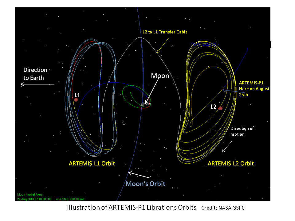
ARTEMIS maneuvers. Credit: NASA

In another case of NASA reusing and recycling spacecraft, two of the five THEMIS spacecraft — which were studying the cause of geomagnetic substorms here on Earth — have a new mission. They made some very unique and complex maneuvers to reach two different LaGrange Points, and will turn their focus on the Moon. Particularly, they will try to determine how the solar wind electrifies, alters and erodes the lunar surface. This is timely since the discovery last year of water across the surface of the Moon which may be created by the solar wind interacting with the lunar surface.

The original THEMIS mission (Time History of Events and Macroscale Interactions during Substorms) featured five satellites that have now successfully completed their 2 year mission. Because they are continuing to work perfectly, NASA is re-directing the outermost two spacecraft to special orbits at and around the Moon. This new mission, which is called ARTEMIS: Acceleration, Reconnection, Turbulence and Electrodynamics of the Moon’s Interaction with the Sun.

[/caption]

It took more than a year and nearly all remaining fuel aboard the satellites to get them to the L1 and L2 Lagrangian points, where one is located on the far side of the Moon, and the other on the Earth-facing side. ARTEMIS-P1 is the first spacecraft to navigate to and perform stationkeeping operations around the Earth-Moon L1 and L2 Lagrangian points.

On August 25, 2010, ARTEMIS-P1 reached the L2 Lagrange point on the far side of the Moon. Following close behind, ARTEMIS-P2 entered the opposite L1 Lagrange point on Oct. 22nd.

Recently, one of the spacecraft was hit by a meteoroid but still seems to be operating.

As the Moon orbits the Earth, it passes in and out of the Earth’s magnetic field and the million-mile per hour stream of solar wind particles. While in these regions, the two ARTEMIS spacecraft will seek evidence for turbulence, particle acceleration, and magnetic reconnection, three fundamental phenomena that control the nature of the solar wind’s interaction with the Earth’s magnetosphere.

By using their instruments and unique two-point vantage points, the spacecraft will study the vacuum the Moon carves out in the solar wind, and the processes that eventually fill this lunar wake. Nearer the Moon, they will observe the effects of surface electric fields, ions sputtered off the lunar surface, and determine the internal structure of the Moon from transient variations in its magnetic field induced by external changes.

Most Intense Storm in History Cuts Across the US — As Seen from Space

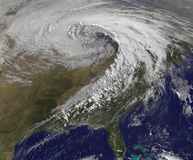
Visible satellite image of the October 26, 2010 superstorm taken at 5:32pm EDT. Image credit: NASA/GSFC.

[/caption]

Yowza! – Here’s a satellite image of a storm of record-breaking proportions. On October 26, 2010, the strongest storm ever recorded in the Midwest spawned 24 tornadoes, 282 reports of damaging winds, violent thunderstorms, and torrential rains. The mega-storm reached peak intensity late yesterday afternoon over Minnesota, resulting in the lowest barometric pressure readings ever recorded in the continental United States (except for from hurricanes and nor’easters affecting the Atlantic seaboard.) The storm continues today (Oct. 27) with more tornado watches posted for Mississippi, Alabama, and Georgia, a blizzard warning for North Dakota, high wind warnings for most of the upper Midwest, and near-hurricane force winds on Lake Superior.

Read more about this super-storm on Weather Underground, but see below for what extremely low air pressure means.

Air pressure is one of the most important factors which determines what the weather is like. A mass of low pressure is an area of air that is rising. As it rises, it expands and cools. Cooler air cannot hold as much water as warmer air, so as the air rises the water will condense and form clouds. This is why an area of low pressure will often be accompanied by clouds and rain — which is what occurred on October 26 — lots of clouds and lots of rain and even snow.

But winds were even a bigger factor in this superstorm. Our atmosphere really doesn’t like big differences in air pressure, so where areas of low pressure meet up with areas of high pressure, winds blow in an attempt to combat the differences in the air pressure. The larger the difference in pressure the stronger the winds will blow. So, the extreme low pressure readings yesterday meant the winds were really howling — and they were. In my neighborhood in Illinois, we had a fairly study flagpole get bent from the winds. But that was nothing compared to the hurricane-like winds other places experienced: for example, Grand Marais, Minnesota — near the Great Lakes and near the area of the lowest air pressure readings — had sustained winds of 43 mph gusting to 59 mph, lasting for over 7 hours. Today, that region is still getting pummeled by winds and snow.

You can see the link to Weather Underground above to see what other weather extremes were experienced during this storm.

Another X-ray Nova Detected by ISS, Swift

The X-ray nova MAXI J1409-619, as observed by the MAXI instrument aboard the ISS. Image Credit: JAXA/RIKEN/MAXI team

[/caption]

A new X-ray emitting object in the Milky Way has been recently announced by the Monitor of All-sky X-ray Image (MAXI) team and the Swift satellite astronomers. MAXI, a Japan Aerospace Exploration Agency supported instrument, monitors the entire sky in the X-ray portion of the spectrum from its perch on the International Space Station module “Kibo”. On October 12th, MAXI noticed nothing out of the ordinary in a portion of the sky in the constellation Centaurus.

On October 17th, however, things started to brighten up in the region but were still dark enough that the team wanted to analyze their observations before announcing it to the world. By the 20th, they were able to confirm the X-ray source as something more unusual, and sent out an Astronomer’s Telegram (ATel No.2959) at 2:00 a.m. EDT alerting other astronomers to the object.

The Swift satellite – in keeping with its name – began taking observations a mere nine hours later. Swift is equipped with an X-ray telescope, as well as an optical/ultraviolet telescope, and is designed to maneuver quickly to home in on gamma-ray bursts (GRBs)

David Burrows, professor of astronomy and astrophysics at Penn State and the lead scientist for Swift’s X-ray Telescope said in a press release, “The Swift observation suggests that this source is probably a neutron star or a black hole with a massive companion star located at a distance of a few tens of thousands of light years from Earth in the Milky Way…The contribution of Swift’s X-ray Telescope to this discovery is that it can swing into position rapidly to focus on a particular point in the sky and it can image the sky with high sensitivity and high spatial resolution.”

The object has been named MAXI J1409-619. The area of the sky that it was discovered in is not a known source of bright X-rays, though there were two dimmer objects located in the same area detected by the BeppoSAX X-ray survey on January 29th, 2000. One of the objects is consistent with the Swift observation, though this most recent flare-up made it almost 52 times brighter in the X-ray than previously observed.

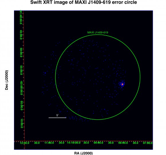
The X-ray nova as seen by the Swift satellite. The bright portion is 0.2 degrees in radius. Image Credit: MAXI/Swift team

X-ray novae are short-lived events, with an initial bright burst that falls off over a period of weeks or months. Their source is generally understood to be material falling into a black hole or accreting onto a neutron star.

This is not the first discovery made by the MAXI instrument. It detected another X-ray source on the 25th of September in the constellation Ophiuchus – named MAXI J1659-152 – which we wrote about here.

Further observations of the new object are likely in the works, so we’ll keep you posted.

Sources: Eurekalert, JAXA, ATel 2965, Penn State Press Release

First Rickroll in Space

Those pranksters from Zug have now gone to the edge of space, sending their own DIY satellite up to 89,000 feet above Earth, and doing a little Rickrolling along the way. They claim they have now pulled the famous prank on the entire planet. Hmmm, hopefully this wasn’t the source of the radio signals that caused ESA’s Soil Moisture and Ocean Salinity (SMOS) probe to be “blinded from interference.” Surely strains of “Never Gonna Give You Up” could never do that….

The video above is a quick look at their balloon satellite launch and their results; here’s the whole story on Zug.

‘Secret’ X-37B Space Plane Disappears Again

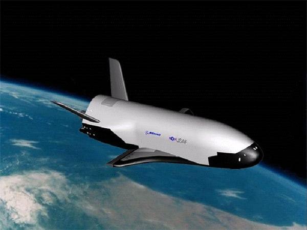
Artist impression of the Boeing X-37B (USAF)

[/caption]

The game between the United States Air Force and amateur satellite trackers continues: the unmanned X-37B space plane – a classified project of the Air Force – has changed orbit once again, leaving those that monitor the flyovers of the space plane scrambling to locate it once again.

The X-37B was launched on April 22nd, 2010 on an Atlas V rocket from Cape Canaveral, Florida, and has been orbiting the Earth ever since. During the period between July 29th and August 14th of this year, the plane changed its orbit and forced the amateurs that monitor the satellite to find it again, and recalculate its orbital path. According to Spaceweather.com yesterday, the X-37B has once again changed its location. It did not pass over at the expected time on the nights of October 7th and October 9th.

Possibilities for this latest change in orbit include a simple maneuvering test or change in the current testing phase of the plane, or the potential that it is finally about to land. The gallium arsenide solar panels on the craft should allow it to stay in space for up to 270 days, but it has only been 173 days since the launch.

The X-37B is controlled remotely, and can automatically land. Once this flight is over, it will land at either the Vandenberg Air Force Base or the Edwards Air Force Base, both located in California.

Not much has been said about the the secret project by the Air Force. Started at NASA in 1999, the automated space plane was handed over to the Pentagon in 2004. This initial flight of the X-37B is billed as a test of the craft by the Air Force. Here’s its description according to the Air Force fact sheet:

“The X-37B Orbital Test Vehicle, or OTV, is a non-operational system that will demonstrate a reliable, reusable, unmanned space test platform for the U.S. Air Force. The objectives of the OTV program include space experimentation, risk reduction and a concept of operations development for reusable space vehicle technologies.”

Of course, there has been much speculation about whether this constitutes the “weaponization of space”, since it is, after all, a project of the Air Force instead of NASA. To put your mind at ease, here’s a link to an analysis of potential uses of the X-37B by former Air Force officer Brian Wheeden, who is now a Technical Adviser to the Secure World Foundation. He places the likelihood that the space plane could be used as a weapon at zero, but its capabilities as an orbital spy platform are feasible.

If you want a comprehensive look into the history and the possible uses of the X-37B, there is a lengthy article over at Air & Space by associate editor Michael Klesius.

There’s also a video up on Space.com by satellite tracker Kevin Fetter of Brockville, Ontario showing a flyover of the plane.

We’ll keep you posted as to when the X-37B is recovered by amateurs, if it has landed, or in the unlikely event that the Air Force decides to release any information about its current mission.

Source: Spaceweather.com

The New Blue Marble

Permian Extinction
A new NASA image of Earth, by Robert Simmon and Marit Jentoft-Nilsen, based on MODIS data.

[/caption]

Despite recent news of potential habitable exoplanets and amazing images of Mars and the Saturn system returned from visiting spacecraft, the ol’ home planet is still about the most gorgeous-looking planetary body out there. We first saw it as a whole “blue marble” when the Apollo astronauts sent back pictures while circling the Moon, and it has been said that the original “Blue Marble” image taken by the Apollo 17 crew has been one of the most viewed and most influential images ever. But truth be told, that “Blue Marble” really wasn’t all that blue (see the original below). However, this new look at the home world shows how prevalent water really is. This composite image is based largely on observations from the Moderate Resolution Imaging Spectroradiometer (MODIS) on NASA’s Terra satellite.

It sure is pretty.

According to the NASA Earth Observatory website, Earth’s water content is about 1.39 billion cubic kilometers (331 million cubic miles), with the bulk of it, about 96.5%, being in the global oceans. As for the rest, approximately 1.7% is stored in the polar icecaps, glaciers, and permanent snow, and another 1.7% is stored in groundwater, lakes, rivers, streams, and soil. Only a thousandth of 1% of the water on Earth exists as water vapor in the atmosphere.

Here’s the original “Blue Marble,” the view of the Earth as seen by the Apollo 17 crew traveling toward the moon. This translunar coast photograph extends from the Mediterranean Sea area to the Antarctica south polar ice cap. This is the first time the Apollo trajectory made it possible to photograph the south polar ice cap. Almost the entire coastline of Africa is clearly visible. The Arabian Peninsula can be seen at the northeastern edge of Africa. The large island off the coast of Africa is Madagascar. The Asian mainland is on the horizon toward the northeast.

The original 'Blue Marble' taken by Apollo 17. Credit: NASA

For larger versions of the top image, see NASA Earth Observatory’s website, and this link for the Apollo 17 version, NASA also has versions of the Blue Marble compiled from various satellites in 2001 and 2002.

Awesome: Father & Son DIY Satellite Captures HD Video from 100,000 ft.

This is a great: amateur rocketeers Luke Geissbuhler and his son Max launched their own DIY satellite via a weather balloon from New York, and using an HD video camera captured some amazing video of the contraption’s rise to near the edge of space (closer than a lot of us will ever get, anyway….) and its plummeting fall. You gotta love their enthusiasm and their “flight tests” at the beginning of the video. It might help that the Dad is a photographer that works in Hollywood films, but then again, I think Max’s countdown and lollipop were the real impetus behind the successful mission. They were able to track the device with GPS, and recover the camera. Lucky for us!

So, You Want to Build a Satellite?

A light-hearted look from the upcoming MAVEN (Mars Atmosphere and Volatile Evolution) mission to Mars of what it takes to create a satellite mission for NASA — even before you ever start building it. And the MAVEN folks should know — NASA has just given the mission a green light to continue the development of the mission, which will investigate the mystery of how Mars lost much of its atmosphere. The approval to proceed followed a review at NASA Headquarters of the detailed plans, instrument suite, budget, and risk factor analysis for the spacecraft. You can see how that all works, (presumably problem free) in this witty little video.
Continue reading “So, You Want to Build a Satellite?”