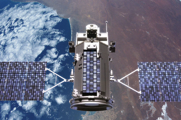
This is a great: amateur rocketeers Luke Geissbuhler and his son Max launched their own DIY satellite via a weather balloon from New York, and using an HD video camera captured some amazing video of the contraption’s rise to near the edge of space (closer than a lot of us will ever get, anyway….) and its plummeting fall. You gotta love their enthusiasm and their “flight tests” at the beginning of the video. It might help that the Dad is a photographer that works in Hollywood films, but then again, I think Max’s countdown and lollipop were the real impetus behind the successful mission. They were able to track the device with GPS, and recover the camera. Lucky for us!
So, You Want to Build a Satellite?
A light-hearted look from the upcoming MAVEN (Mars Atmosphere and Volatile Evolution) mission to Mars of what it takes to create a satellite mission for NASA — even before you ever start building it. And the MAVEN folks should know — NASA has just given the mission a green light to continue the development of the mission, which will investigate the mystery of how Mars lost much of its atmosphere. The approval to proceed followed a review at NASA Headquarters of the detailed plans, instrument suite, budget, and risk factor analysis for the spacecraft. You can see how that all works, (presumably problem free) in this witty little video.
Continue reading “So, You Want to Build a Satellite?”
No Glory: NASA Delays Climate Change Satellite Mission
[/caption]
A satellite mission to study climate change on Earth has been delayed due to problems with its solar arrays. The Glory mission was scheduled for a November 22, 2010 launch, but it now has been tentatively pushed back to February 23, 2011. Reportedly, ground testing revealed a problem with a mechanism in one of the two solar panels on the Glory satellite. “The new launch date provides the necessary additional time required to complete preparations for the rocket and the spacecraft,” said a NASA status report issued on Friday. The mission is slated to launch on an Orbital Sciences Taurus XL rocket from Vandenberg Air Force Base in California.
The $424 million Glory mission will gather data to help scientists to better understand the Earth’s energy budget. It will look at the properties of aerosols, including black carbon, in the Earth’s atmosphere and climate system, and enable a greater understanding of the seasonal variability of aerosol properties.
It will also collect data on solar irradiance for the long-term effects on the Earth climate record, helping to help in our understanding whether the temperature increase and climate changes are by-products of natural events or whether the changes are caused by man-made sources is of primary importance.
On the last Taurus XL launch in February 2009 — for the Orbiting Carbon Observatory, another NASA climate change research satellite — a fairing failed to separate, and the mission failed.
Source: KSC
New Satellite Launches to Track Space Junk
[/caption]
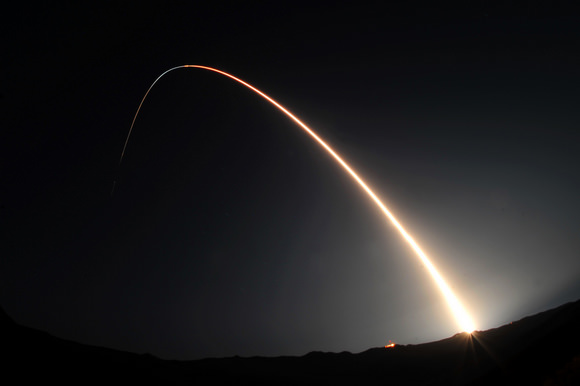
The U.S. Air Force successfully launched the Space Based Space Surveillance spacecraft, a first-of-its-kind satellite that can detect and track orbiting space objects from space. The new satellite was blasted into orbit by a Minotaur IV rocket at 9:41 p.m. PDT, September 25th, from Vandenberg Air Force Base in California.
“SBSS will greatly enhance our existing space situational awareness capability, a capability vital to protecting our space-based assets,” said Colonel Richard Boltz from Vandenberg.

There are about 500,000 known pieces of space junk – such as spent rocket boosters, failed satellites, and pieces of satellites – in Earth orbit. Of those, about 21,000 objects are larger than 10.1 cm (4 inches) in diameter. These are being tracked by the Department of Defense, as part of the Space Surveillance Network.
“This satellite is going to revolutionize the way we track objects in space by not being constrained by weather, the atmosphere or the time of day,” said Col. J.R. Jordan, vice-commander of the Space Superiority Systems Wing at the U.S. Air Force Space and Missile Systems Center, in a prelaunch briefing. “This capability will be essential to our space situational awareness architecture for the near future and beyond.”
The satellite will be fully operational and handed over to the Air Force Space Command in about 210 days. The SBSS will be able to detect, identify and tracking man-made space objects from deep space to low-earth orbit. The SBSS space vehicle uses a two-axis gimbal in order to observe in all directions. The spacecraft’s on-board mission data processor performs image processing to extract moving targets and reference star pixels to reduce the downlink data size.
This was the third launch in eight days from Vandenberg.
Source: Vandenberg AFB
Possibility for White Dwarf Pulsars?
[/caption]
Some satellites get all the glory. While Hubble, Chandra, and Spitzer frequently make headlines with their stunning images, many other space based observatories silently toil away. One of them, known as the Payload for Antimatter Matter Exploration and Light-nuclei Astrophysics (PAMELA) has been in orbit since 2006, but rarely receives media attention although a stunning discovery has led to the publication of over 300 papers within a single year. A new paper in that onslaught has proposed an interesting new object: pulsars powered by white dwarfs.
PAMELA isn’t a satellite in its own right. It piggybacks on another satellite. Its mission is to observe high energy cosmic rays. Cosmic rays are particles, whether they be protons, electrons, nuclei of entire atoms, or other pieces, that are accelerated to high velocities, often from exotic sources and cosmological distances.
Among the types of particles PAMELA detects is the elusive positron. This anti-particle of the electron is quite rare due to the scarcity of anti-matter in general in our universe. However, much to the surprise of astronomers, in the range of 10 – 100 GeV, PAMELA has reported an abundance of positrons. In even higher ranges (100 GeV – 1 TeV) astronomers have found that there is a rise in both electrons and positrons. The conclusion from this is that something is able to actually create these particles in these energy ranges.
A flurry of papers went to publication to explain this unexpected finding. Explanations ranged from showers of particles created by even higher energy cosmic rays striking the interstellar medium, to the decay of dark matter, to neutron stars, pulsars, supernovae, and gamma ray bursts. Indeed, many events that produce high energies are sufficient to spontaneously produce matter from energy through the process of pair production. However, the range of these ejected particles would be limited. Effects, such as synchrotron and inverse Compton emission would drain their energy over large distances and as such, by the time they reached PAMELA’s detectors would be too low energy to account for the excesses in the observed energy ranges. From this, astronomers are presuming the culprits are in the local universe.
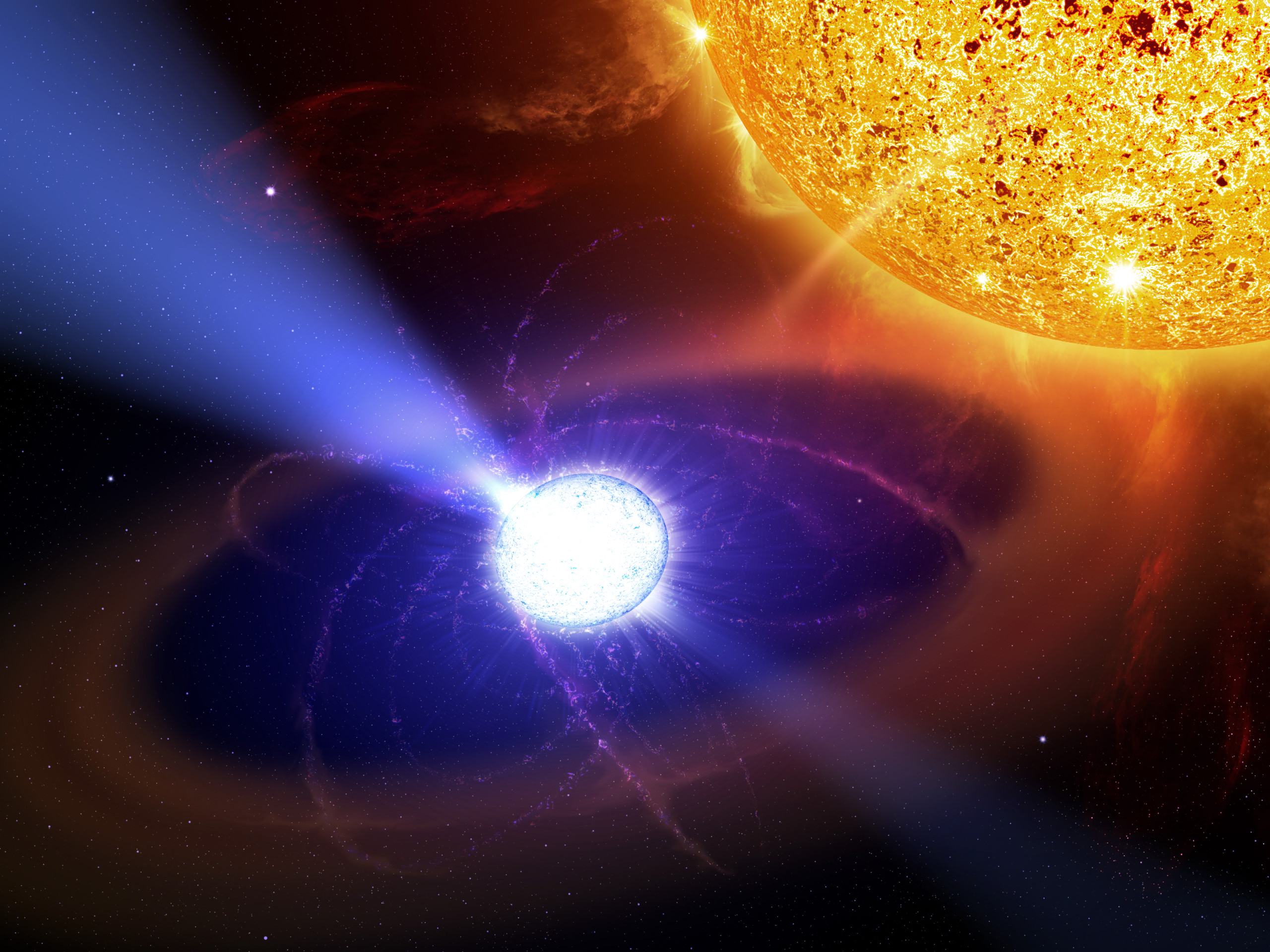
Joining the long list of candidates, a new paper has proposed a mundane object could be responsible for the high energy necessary to create these energetic particles, albeit with an unusual twist. Neutron stars, one of the potential objects formed in a supernova, are known to release large amounts of energies when spinning quickly while creating a strong magnetic field in the form of pulsars, but the authors propose that white dwarfs, the products of the slow death from stars not massive enough to result in a supernova, may be able to do the same thing. The difficulty in creating such a white dwarf pulsar is that, since white dwarfs don’t collapse to such a small size, they don’t “spin up” as much as they conserve angular momentum and shouldn’t have the sufficient angular velocity necessary.
The authors, led by Kazumi Kashiyama at Kyoto University propose that a white dwarf may reach the necessary rotational speed if they undergo a merger or accrete a sufficient amount of mass. This idea is not unheard of since white dwarf mergers and accretion are already implicated in Type Ia Supernovae. The combination of this with the expectation that around 10% of white dwarfs are expected to have magnetic fields of 106 Gauss, the steps necessary to produce a pulsar from a white dwarf seem to be in place. They note that since white dwarfs tend to have weaker magnetic fields, they shed their angular momentum more slowly and would last longer. Although this duration is still far longer than humans can possibly watch, this may indicate that many of the pulsars observed in our own galaxy are white dwarfs.
Next, the authors hope to conclusively identify such a star. The creation of each of these types of pulsars may provide a clue: Since neutron stars form from supernovae, they are surrounded by a shell of gas that contains a shock front from the supernova itself, which is more dense than the interstellar medium in general. As particles pass through this shock front, some of them would be lost. The same would not be said for white dwarfs which formed from a more gentle release and aren’t impeded by the relatively high density area. This shift in energy distributions may be one distinguishing characteristic.
Some stars have even been tentatively proposed as candidates for white dwarf pulsars. AE Aquarii was seen to give off some pulsar-like signals. EUVE J0317-855 is another white dwarf that appears to meet the qualifications, although no signals have been detected from this star. This new class of stars would be able to explain the excess signal in the higher energy range detected by PAMELA and will likely be the target of further observational searches in the future.
Satellite Images Show Hurricane Igor Likely to Make Direct Hit on Bermuda
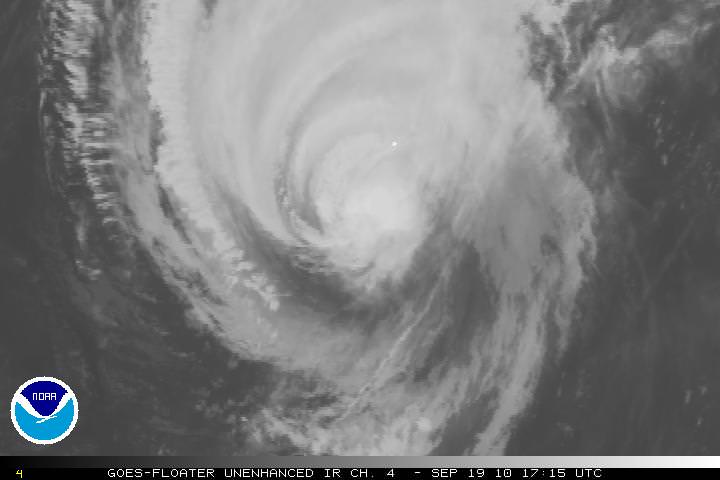
[/caption]
The massive Hurricane Igor is now a Category One storm, with maximum sustained wind speeds of 140 km per hour, (85 miles per hour). As of this writing at 2:30 EDT, it looks as if it is on a direct collision course with Bermuda and is about 220 km (135 miles) southwest of Bermuda. The intensity of the storm has decreased over the past few days, but the size and rotation of the Igor means that Bermuda will be hit repeatedly as the arms of the hurricane spin over the 54 square kilometer (21 sq mi) island nation. In the satellite image above, Bermuda is the small white dot near the center of the image.
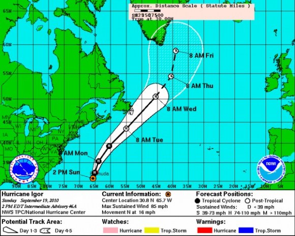
Damaging sustained winds of hurricane force will reach the Bermuda late Sunday afternoon, and they will continue into early Monday morning. Wind gusts are predicted to be near or just over 160 km/hour (100 mph) as Igor makes its closest approach to Bermuda. Here’s a link to even more hurricane images.
The hurricane threatens to leave widespread tree damage and power outages in its wake. Some structures will also sustain damage; but fortunately, many buildings on Bermuda are made of stone with foundations into bedrock.
Flooding is also a serious concern across Bermuda. Igor will not only drop 4 to 8 inches of rain but will also trigger a 6- to 10-foot storm surge. Worsening the situation is the fact that waves pounding Bermuda will rise to heights in excess of 40 feet into this evening.
The massive size of Igor will cause the hurricane to keep battering the island well into Monday afternoon.
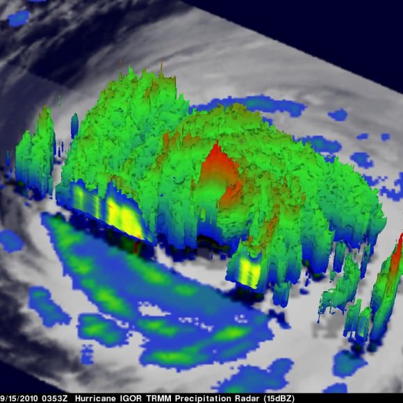
This 3-D image of Igor’s cloud heights and rainfall from NASA TRMM data shows a large area of heavy rainfall (falling at about 2 inches per hour) shown here in red on Sept. 15 at 0353 UTC. The yellow and green areas indicate moderate rainfall between .78 to 1.57 inches per hour. The image reveals that Igor’s eye was still very distinct but the southwestern portion of the eye wall had eroded.
Sources: NOAA, AccuWeather, JPL
Students Send ICESat to a Fiery Deorbit Death
[/caption]
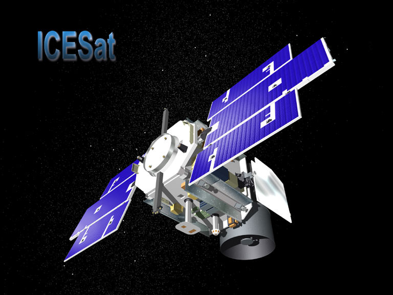
NASA’s Ice, Cloud, and land Elevation (ICESat) mission is now on ice, so to speak, or perhaps we should say, it ultimately became an inferno. The satellite was intentionally deorbited and burned up in the atmosphere on August 30, after completing a very productive seven-year scientific stint in orbit. And talk about the ultimate high-stakes, high-adventure, hands-on student project: students at the University of Colorado Boulder conducted the final maneuvers to send the spacecraft to its fiery death.
ICESat’s science mission ended in February 2010 when its primary instrument failed. NASA lowered the satellite’s orbit this summer and then decommissioned the spacecraft in preparation for re-entry. The satellite largely burned up, (NASA calculated that no more than 90 kg (200 pounds) of the ICESat’s original 900 kg (2,000 pounds) would survive re-entry) with pieces of debris falling into the Barents Sea, part of the Arctic Ocean north of Norway and Russia.
Originally a slated for 3 year mission, it continued for seven years and 15 laser-operations campaigns. While the GLAS instrument failed, the spacecraft itself remained in operating condition, so NASA could fire its thrusters to lower its orbit. This began in June, and reduced the lowest point of the spacecraft’s orbit to 125 miles (200 km) above Earth’s surface. The orbit then naturally decayed, but the final maneuvering was controlled by a group of students from the University of Colorado, working at the school’s Laboratory for Atmospheric and Space Physics (LASP). They sent it successfully plummeting through Earth’s atmosphere at just the right moment so that the satellite’s remains would land in the chilly – and uninhabited — seas north of Norway and Russia.
“They ran calculations to determine where the spacecraft was located,” said Darrin Osborne, flight director for ICESat.
The student operators provide a lower cost to NASA, and CU students at LASP receive hands-on training and experience that helps position them for a future in space-related careers.
“It’s amazing for an undergraduate like me to get hands-on experience controlling multimillion-dollar NASA satellites,” said third-year aerospace engineering sciences student Katelynn Finn, quoted in an article in The Register.
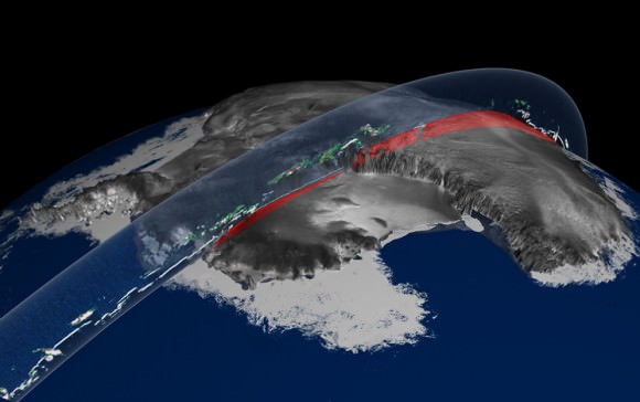
ICESat was launched in January, 2003, and was the first mission of its kind, designed to study Earth’s polar regions with a space-based laser altimeter called the Geoscience Laser Altimeter System, or GLAS. ICESat has helped in our understanding of ice sheet and sea ice dynamic, leading to scientific advances in measuring changes in the mass of the Greenland and Antarctic ice sheets, polar sea ice thickness, vegetation-canopy heights, and the heights of clouds and aerosols. Using ICESat data, scientists identified a network of lakes beneath the Antarctic ice sheet. ICESat introduced new capabilities, technology and methods such as the measurement of sea ice freeboard – or the amount of ice and snow that protrudes above the ocean surface – for estimating sea ice thickness.
A final eulogy for the satellite was offered by NASA’s Earth Science Mission Operations office: “The ICESat mission operations team is commended for its exceptional performance, working tirelessly for the past eleven years (four years of preparation and seven years of operations), overcoming several obstacles in the early years of the mission, and closing out the mission with a flawless series of orbital maneuvers before final decommissioning. The positive control maintained over the mission right to the end shows the quality and effort that went into designing, building, qualifying, launching, and operating a tremendously successful mission such as ICESat.”
Two Chinese Satellites Rendezvous in Orbit
[/caption]
Data from the US military shows that two Chinese satellites likely performed multiple rendezvous 600 kilometers above Earth this summer, and may have even bumped into each other. The rendezvous have taken place over the past several months, between two Chinese “Shi Jian” (Practice) spacecraft, SJ-06F and SJ-12, that are officially listed as science satellites.
News of the Chinese satellite encounters was first reported by a Russian news source in mid-August, and this week Brian Weeden from the Secure World Foundation wrote an extensive article for The Space Review.
Weeden said the maneuvers could be a rehearsal for the technology needed to build a space station, but it also shows China may now have the ability to approach and potentially interfere with other satellites.
“On-orbit rendezvous is a complex operation, and one that has only been done a few of times before, most notably by the US satellite XSS-11,” Weeden wrote, “which inspected the rocket body that placed it in LEO, and one of the US MiTEx satellites, which inspected the failed DSP-23 satellite in GEO. The rendezvous of two Chinese satellites demonstrates that China is broadening its space capabilities, but also touches on the greater issue of perceptions, trust, and safety in space activities that could impact the long-term sustainability of the space regime.”
Weeden said US military data suggests that one satellite may have been bumped and its orbit altered slightly on August 19. The change in its orbit can’t be explained by the usual things that affect satellites, such as the drag from the Earth’s atmosphere.
In January 2007, China destroyed a derelict satellite with a ballistic missile, which the US also did in February 2008.
For now, one can only speculate about the reasons for China performing these types of difficult and rare maneuvers with their satellites. You can read more about the technical nature of the events on The Space Review.
Satellite Captures Three Tropical Cyclones in One Image
[/caption]
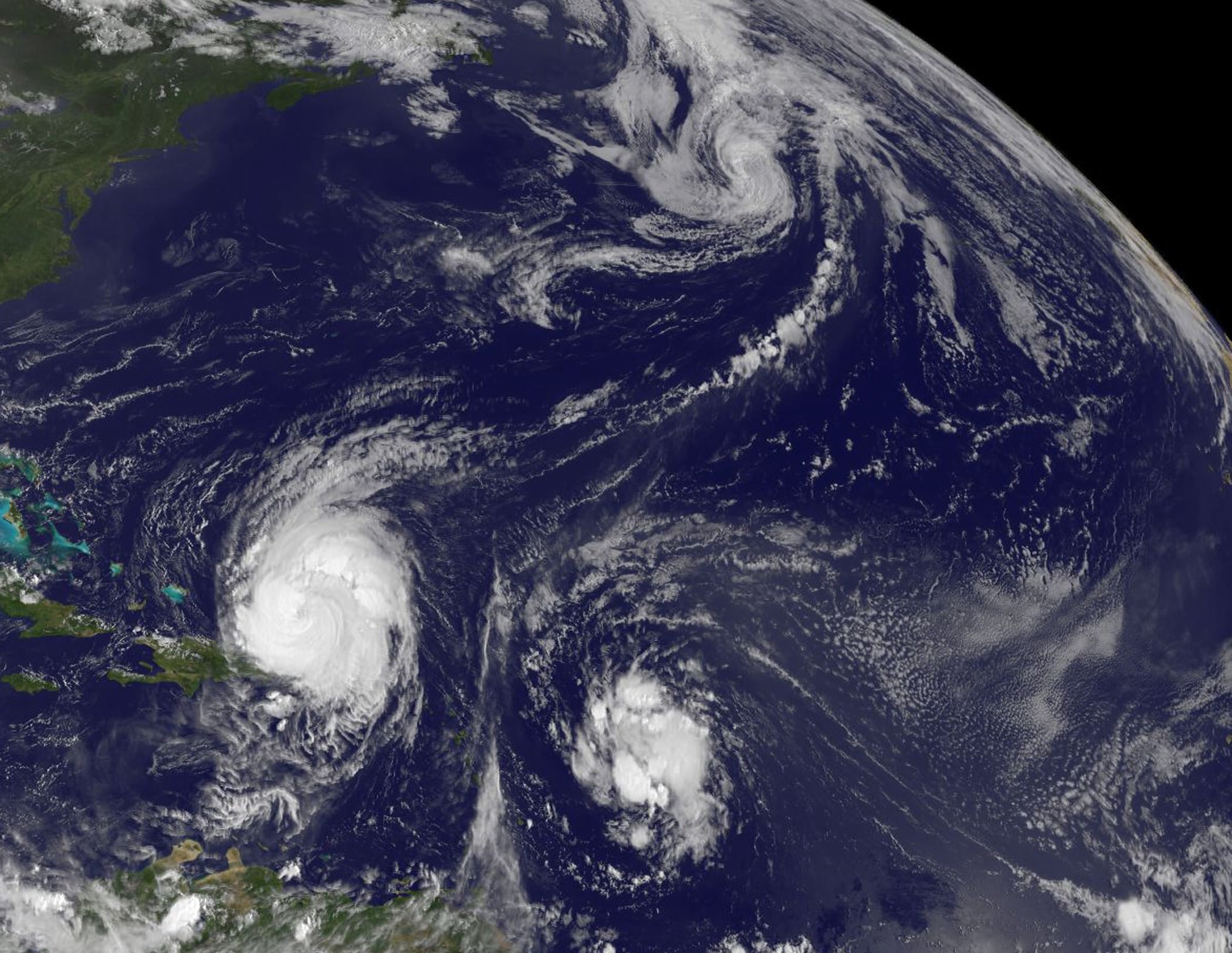
My father had a favorite adage when life was hectic: “There’s lots of commotion in the ocean.” That saying was never more true than the current situation in the busy Atlantic Ocean. The GOES-13 satellite captured this image earlier today (Tuesday Aug. 31) and visible are three areas of tropical commotion. The large and powerful Hurricane Earl (lower left) is passing Puerto Rico, Tropical Storm Fiona located to Earl’s east, and Tropical Storm Danielle far in the Northern Atlantic. Below is footage taken by the International Space Station of the action.
Hurricane Earl is a storm that’s about 640 km (400 miles) in diameter and the hurricane force winds are about 225 km (140 miles) in diameter from side-to-side of the storm’s eye. Earl is still a Category Four hurricane on the Saffir-Simpson scale, one category stronger than Hurricane Katrina was when she made landfall in Mississippi in 2005.
A tropical storm warning is in effect for Turks and Caicos Islands and a tropical storm watch is in effect for the southeastern Bahamas. Meanwhile, residents from the Carolinas northward to New England in the US should be watchful of where Earl is heading. A hurricane watch could be required for portions of the mid-Atlantic coast later today.
Tropical Storm Fiona is moving through the same areas that Hurricane Earl battered a few days ago, but with less force. A tropical storm warning is in effect for St. Martin and St. Barthelemy. A tropical storm watch is in effect for, Antigua, Barbuda, Montserrat, St. Kitts, Nevis, and Anguilla and St. Maarten, Saba, and St. Eustatius. The National Hurricane Center noted in its forecast this morning, August 31, that Tropical storm conditions could spread over portions of the Northern Leeward Islands tonight or early Wednesday.
At 11 a.m. EDT, Tropical Storm Fiona had maximum sustained winds near 65 kph (40 mph) and some strengthening is possible. Fiona is moving west-northwest near 38 kph (24 mph) and is expected to slow down.
Tropical cyclones are warm-core systems, so when the core temperatures change, the dynamics of the system also changes. Today, Danielle transitioned into a cold-core low pressure area in the Northern Atlantic Ocean. Her sustained winds were near 112 kph (70 mph), but waning.
Danielle’s effects are being felt along the shores of Newfoundland with heavy surf and waves up to 3 meters (10 feet).
The Geostationary Operational Environmental Satellite project was developed by NASA for the National Oceanic and Atmospheric Administration (NOAA). The GOES satellites are funded by NOAA, while the Goddard Space Flight Center procures and manages the development and launch of the GOES satellites while NOAA manages the operational environmental satellite program and establishes requirements, provides all funding and distributes environmental satellite data for the United States.
Source: NASA
Satellite Data Show Plant Growth is Declining on Earth
[/caption]
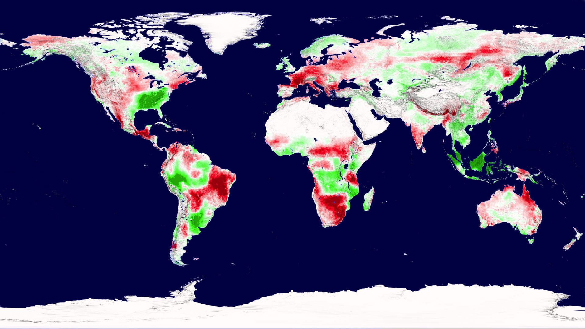
One idea about climate change suggested that higher temperatures would boost plant growth and food production. That may have been a trend for awhile, where plant growth flourished with a longer growing season, but the latest analysis of satellite data shows that rising global temperatures has reached a tipping point where instead of being beneficial, higher temperatures are causing drought, which is now decreasing plant growth on a planetary scale. This could impact food security, biofuels, and the global carbon cycle. “This is a pretty serious warning that warmer temperatures are not going to endlessly improve plant growth,” said Steven Running from the University of Montana.
During the 1980s and 1990s global terrestrial plant productivity increased as much as six percent. Scientists say that happened because during that time, temperature, solar radiation and water availability — influenced by climate change — were favorable for growth.
During the past ten years, the decline in global plant growth is slight – just one percent. But it may signify a trend.
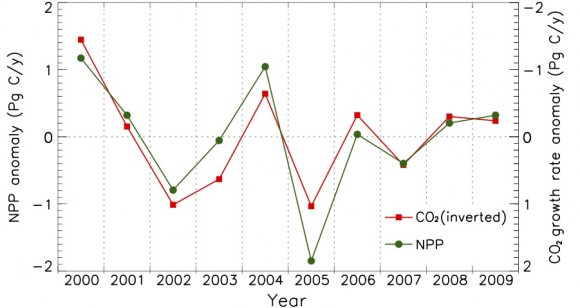
“These results are extraordinarily significant because they show that the global net effect of climatic warming on the productivity of terrestrial vegetation need not be positive — as was documented for the 1980’s and 1990’s,” said Diane Wickland, of NASA Headquarters and manager of NASA’s Terrestrial Ecology research program.
A 2003 paper in Science led by then University of Montana scientist Ramakrishna Nemani (now at NASA Ames Research Center, Moffett Field, Calif.) showed that land plant productivity was on the rise.
Running and co-author Maosheng Zhao originally set out to update Nemani’s analysis, expecing to see similar results as global average temperatures have continued to climb. Instead, they found that the impact of regional drought overwhelmed the positive influence of a longer growing season, driving down global plant productivity between 2000 and 2009.
The discovery comes from an analysis of plant productivity data from the Moderate Resolution Imaging Spectroradiometer (MODIS) on NASA’s Terra satellite, combined with growing season climate variables including temperature, solar radiation and water. The plant and climate data are factored into an algorithm that describes constraints on plant growth at different geographical locations.
For example, growth is generally limited in high latitudes by temperature and in deserts by water. But regional limitations can vary in their degree of impact on growth throughout the growing season.
Zhao and Running’s analysis showed that since 2000, high-latitude northern hemisphere ecosystems have continued to benefit from warmer temperatures and a longer growing season. But that effect was offset by warming-associated drought that limited growth in the southern hemisphere, resulting in a net global loss of land productivity.
“This past decade’s net decline in terrestrial productivity illustrates that a complex interplay between temperature, rainfall, cloudiness, and carbon dioxide, probably in combination with other factors such as nutrients and land management, will determine future patterns and trends in productivity,” Wickland said.
The researchers plan on maintaining a record of the trends into the future. For one reason, plants act as a carbon dioxide “sink,” and shifting plant productivity is linked to shifting levels of the greenhouse gas in the atmosphere. Also, stresses on plant growth could challenge food production.
“The potential that future warming would cause additional declines does not bode well for the ability of the biosphere to support multiple societal demands for agricultural production, fiber needs, and increasingly, biofuel production,” Zhao said.
“Even if the declining trend of the past decade does not continue, managing forests and croplands for multiple benefits to include food production, biofuel harvest, and carbon storage may become exceedingly challenging in light of the possible impacts of such decadal-scale changes,” Wickland said.
The team published their findings Aug. 20 in Science.
Source: NASA

