[/caption]
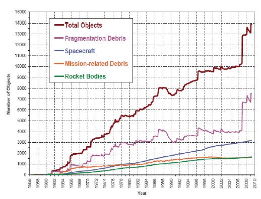
The effects of climate change can be seen across the majority of the planet, but a new study reveals it is also affecting the space environment. New Scientist reports that increased carbon dioxide levels are cooling the upper atmosphere, which decreases the atmospheric density. This in turn affects how long defunct satellites, spent rocket boosters and other space debris stay in orbit, contributing to the space junk problem.
Atmospheric drag creates a braking effect on space debris, and eventually causes the various bits and pieces to drop out of orbit and burn up. Two researchers at the University of Southampton in the UK, Arrun Saunders and Hugh Lewis, studied the orbits of 30 satellites over the past 40 years, and recorded a gradual increase in the time they remain in orbit.
They calculated that at an altitude of 300 kilometers, the atmosphere is reducing in density by 5 per cent every decade. “The lower molecular braking means debris can remain in orbit up to 25 per cent longer,” said Lewis.
This raises the risk of collisions with satellites and makes it more hazardous to launch spacecraft. Space agencies and commercial launch companies may need to step up the current space debris mitigation procedures now in place, which include employing on-board passive measures to eliminate the potential for explosions from batteries, fuel tanks, propulsion systems and pyrotechnics, which helps reduce the number of objects in orbit. Or we may need to find a way to remove debris from orbit sooner rather than later.
Saunders and Lewis presented their work at a conference in Boulder, Colorado, last week.
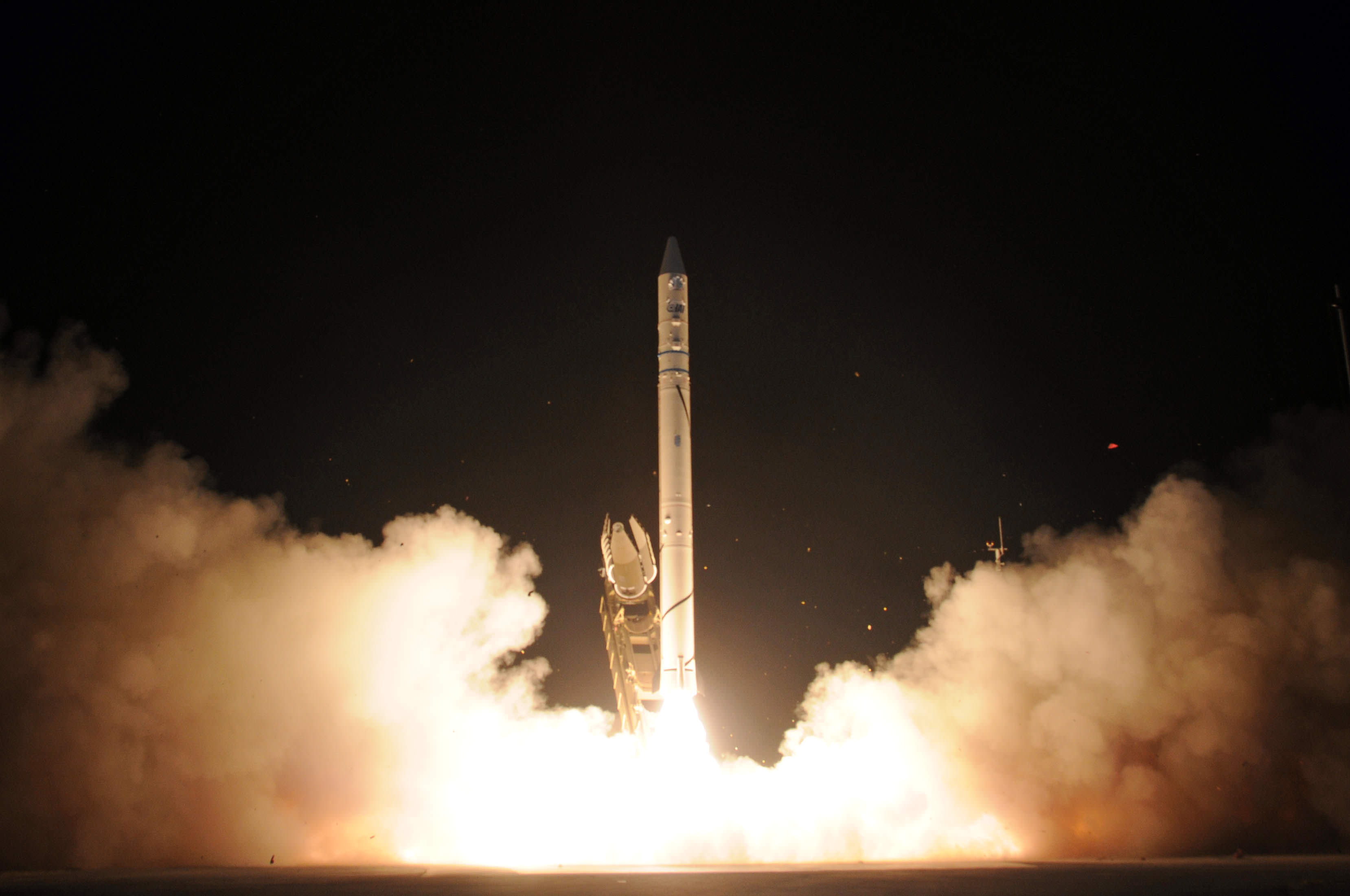
Israel launched an “Ofeq 9” satellite on Tuesday, an advanced remote sensing satellite that likely is capable of high resolution surveillance to monitor Iran’s nuclear program. The satellite was launched on Israel’s Shavit launch vehicle.
The Israel Defense Ministry gave no public details on the satellite, only releasing this statement following the launch: “A few minutes ago the State of Israel launched the Ofek-9 (Horizon-9) satellite from the Palmachim base (Israel’s Air Force test range). The results of the launch are being examined by the technical team.”
But in an Israel Defense Ministry document provided to Universe Today, the Ofeq 9 satellite was listed as capable of scanning a swath 7 km wide, with a resolution better than 70 cm and a pointing accuracy to within 20 meters. The satellite will initially be launched to an elliptical transfer orbit – 620 x 307 Km, and following the checkout, the final orbit will be approximately 500 km above Earth.
The Shavit launcher is a 3-stage launcher, 20 meters high and weighs approximately 30 tons.
With the launch of Ofeq-9, Israel has six spy satellites in space.
The satellite was made by Israel Aerospace Industries Ltd. The Shavit launcher has been in use since 1988, when the first Ofeq satellite was put into orbit.
Israel, which has the Middle East’s sole undeclared nuclear arsenal, regards Iran as its principal threat after repeated predictions by the Islamic republic’s hardline President Mahmoud Ahmadinejad of the Jewish state’s demise, according to news reports from Jerusalem. Israel suspects Iran of trying to develop atomic weapons under the guise of its nuclear program, a claim Tehran denies.
Sources: SpaceTravel.com, and special thanks to Avi Blizovsky, Editor Hayadan Science News in Israel.
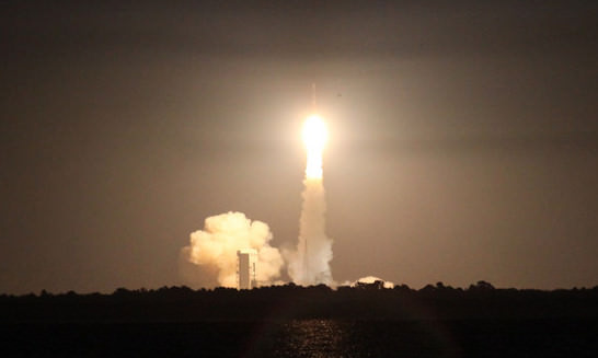
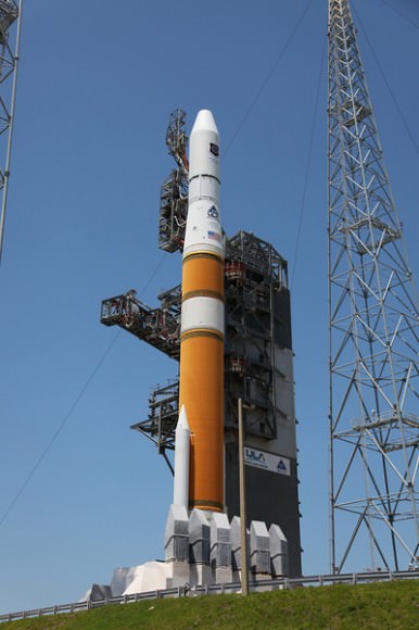
The first in a series of next-generation GPS satellites launched late Thursday from Cape Canaveral launch Complex 37 on board a Delta IV rocket. The Air Force’s Global Positioning System GPS IIF SV-1 satellite blasted off at 11 p.m. EDT on May 27, 2010, after overcoming three different launch aborts over the last week due to weather and technical glitches. Following its three hour, 33 minute flight into orbit, the new satellite has reached its orbit 18,000 km (11,000 miles) above the Earth, joining a constellation of 24 other GPS satellites that aids in military operations and helps civilians navigate the planet. Boeing, who built the satellite for the Air Force, said they acquired the first on-orbit signals from the new satellite early Friday, and all indications are that the spacecraft bus is functioning normally and ready to begin orbital maneuvers and operational testing.
This new era of GPS satellites are solar powered, designed for a minimum 12-year life. There will be a constellation of 12 of these new navigation satellites, which will have twice the signal accuracy of previous GPS satellites and are equipped with a new signal capability for more robust civilian and commercial aviation applications, Boeing said.
For the United Launch Alliance, which prepared the Delta IV rocket, this was the 41st successful launch in the 41 months and six days since the company was created as a joint venture between Lockheed Martin Corp. and Boeing Co. This launch also marked a milestone for the Delta rockets. The first Delta rocket, called a Thor-Delta booster, launched 50 years ago on May 13, 1960.
The Delta IV was first launched in 2002, and this is the rocket’s 13th successful flight. GPS IIF-SV1 is the first GPS satellite to launch on a Delta 4. Previous navigation satellites were launched on the smaller Delta 2 boosters, and upcoming GPS IIF constellation satellites are expected to fly on the Delta IV rockets or Atlas 5 boosters.
Confirming some of the worst fears about the Deepwater Horizon oil spill in the Gulf of Mexico, satellite images now show part of the oil slick has entered the Loop Current, a powerful conveyor belt-like current that flows clockwise around the Gulf of Mexico towards Florida. The Loop Current joins the Gulf Stream — the northern hemisphere’s most important ocean-current system — and the oil could enter this system and be carried up to the US East Coast.
Both NASA and ESA satellites have been returning daily satellite images of the oil spill.
“With these images from space, we have visible proof that at least oil from the surface of the water has reached the current,” said Dr Bertrand Chapron of Ifremer, the French Research Institute for Exploitation of the Sea.
During the first weeks following the explosion at the oil rig, oil could be seen drifting from the site of the incident and it usually headed west and northwest to the Mississippi River Delta. But in the third week of May, currents drew some of the oil southeast. According to the National Oceanic and Atmospheric Administration (NOAA), the southward spread increased the chance that the oil would become mixed up with the Loop Current and spread to Florida or even the U.S. East Coast.
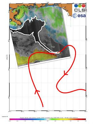
In this Envisat Advanced Synthetic Aperture Radar (ASAR) image, acquired on 18 May 2010, a long tendril of the oil spill (outlined in white) is visible extending down into the Loop Current (red arrow).
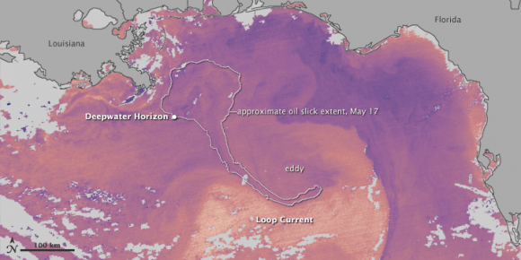
The infrared image is annotated with the location of the leaking well and the approximate location of the southern arm of the oil slick on May 17 (based on natural-color MODIS imagery). Oil was very close to the Loop Current, whose warm waters appear in yellow near the bottom of the image. However, there is also an eddy of cooler water (purple) circulating counterclockwise at the top of the Loop Current. According to NOAA, “Some amount of any oil drawn into the Loop Current would likely remain in the eddy, heading to the northeast, and some would enter the main Loop Current, where it might eventually head to the Florida Strait.”
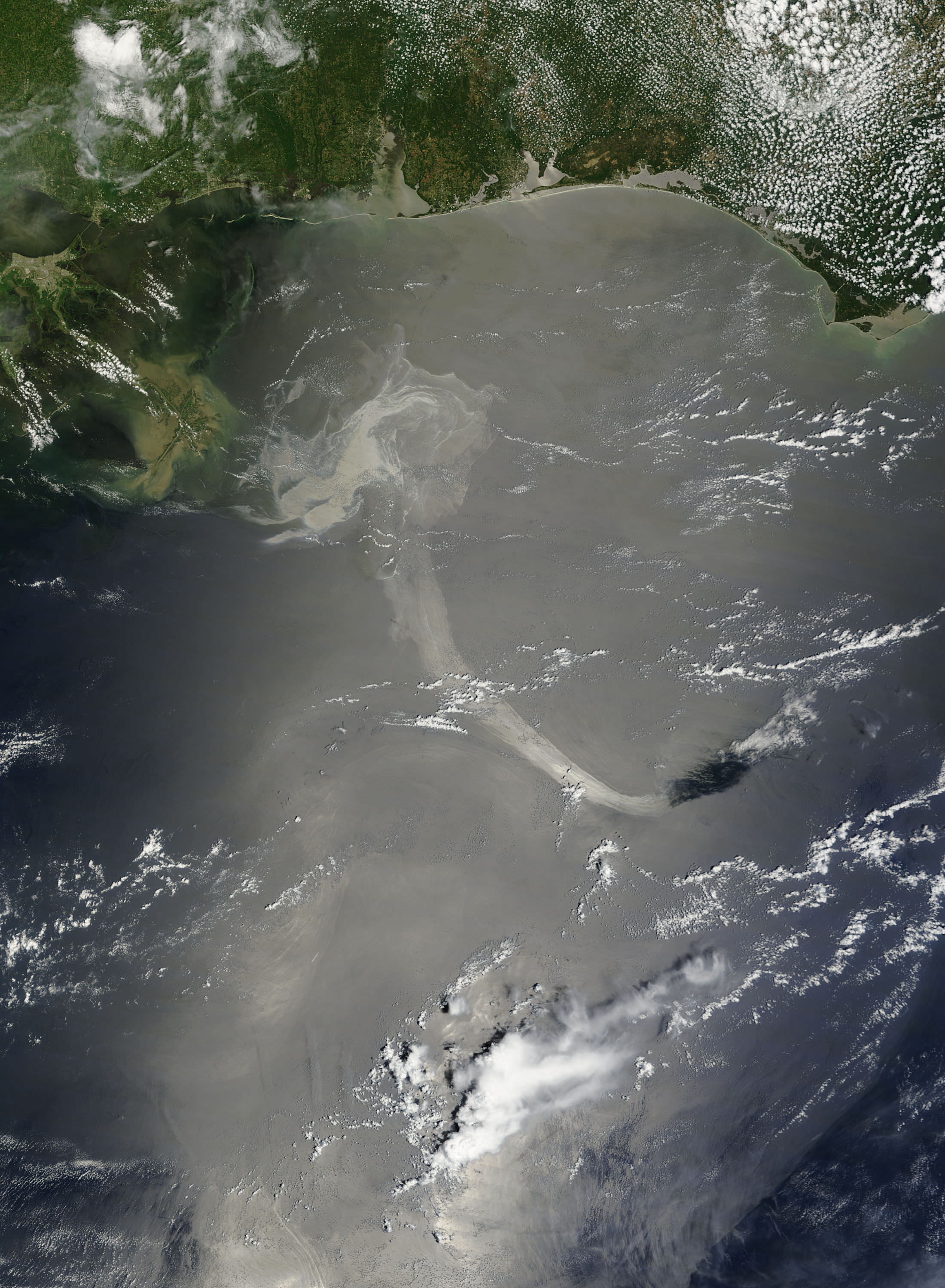
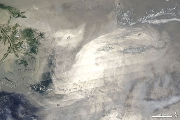
This unusual natural color image taken on May 18, 2010 by the Moderate Resolution Imaging Spectroradiometer (MODIS) on NASA’s Aqua satellite shows sun glinting off the oil slick. The diagonal stripes result from the Sun’s reflection on the ocean surface, called sunglint. The sunglint accentuates the left-to-right scans that the satellite sensor makes as it passes over the Earth’s surface, and the stripes are perpendicular to the satellite’s path.
Besides hinting at the sensor’s scans, the sunglint also illuminates oil slicks on the sea surface. Bright oil slicks appear east and southeast of the delta.
NASA’s and ESA’s satellites will keep watch on this oil slick from above.
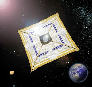
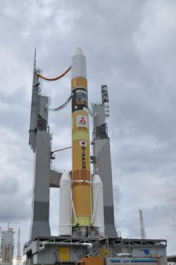
Bad weather postponed a scheduled multi-mission launch of an H-IIA rocket from Japan early Tuesday, which includes the first Japanese probe to Venus and an experimental solar sail. The next launch attempt for the “Akatsuki” Venus Climate Orbiter and the solar sail called IKAROS will be Thursday, May 20, at 21:58 UTC (May 20 at 5:58 EDT) – which is May 21 at 6:58 in Japan. Akatsuki is Japan’s first mission to Venus, and it will work closely with the ESA’s Venus Express, already at Venus. Also called Planet C, the box-shaped orbiter should arrive at Venus in December and observe the planet from an elliptical orbit, from a distance of between 300 and 80,000 kilometers (186 to 49,600 miles), looking for — among other things — signs of lightning and active volcanoes.
[/caption]
Another payload is the solar sail, or “space yacht” IKAROS (Interplanetary Kite-craft Accelerated by Radiation of the Sun). This 320kg, 1.8m-wide, disc-shaped spacecraft will deploy an ultra-thin, ultra-light, 14 meter sail that will propel the structure from the radiation pressure from sunlight hitting it.
“The purpose of IKAROS is to demonstrate the technology of the Solar Power Sail,” said Osamu Mori, project leader of IKAROS. “Simply put, the solar sail is a ‘space yacht.’ A yacht moves forward on water, pushed by wind captured in its sails. A solar sail is propelled by sunlight instead of wind, so it’s a dream spaceship – it doesn’t require an engine or fuel. Part of IKAROS’s sail is covered by a solar cell made of an ultra-thin film, which generates electricity from sunlight.”
So far, solar sails have only been tested, but never flown successfully. It is hoped IKAROS will be the world’s first solar-powered sail, and that the structure will sail towards Venus, following Akatsuki.
The experimental sail is thinner than a human hair, is also equipped with thin-film solar cells to generate electricity, creating what JAXA calls “a hybrid technology of electricity and pressure.”
To control the path of IKAROS, engineers will change the angle at which sunlight particles bounce off the sail.
If you are a member of The Planetary Society, your name will be heading to Venus on both Akatsuki and IKAROS. The Planetary Society, a long-time proponent of solar sail technology, and Japan’s space exploration center, JSPEC/JAXA, have an agreement to collaborate and cooperate on public outreach and on technical information and results from IKAROS, which will help TPS plan for its upcoming launch of its own solar sail vehicle, LightSail-1, which they hope to launch in early 2011.
The H-IIA will also carry four other small satellites, developed by Japanese universities and other institutions. They include:
The 2-pound Negai CubeSat, developed by Soka University of Japan. Negai will test an information processing system during a three-week mission.
The WASEDA-SAT2, developed by Waseda University. The 2.6-pound spacecraft will conduct technology experiments in orbit.
The 3.3-pound KSAT spacecraft developed by Kagoshima University will conduct Earth observation experiments.
The 46-pound UNITEC-1 satellite from the Japanese University Space Engineering Consortium will test computer technologies and broadcast radio waves from deep space for decoding by amateur radio operators.
The rocket will launch from Japan’s Tanegashima Space Center in southern Japan.
[/caption]
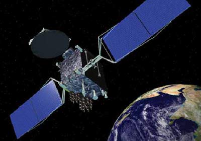
A geostationary satellite that had its “brains fried” by a solar flare (love that description by our pal Ian O’Neill at Discovery Space) stopped communicating with ground controllers last month and remains out of control. While the Galaxy 15 communication satellite is still functional, its navigation and communications system are not. The instruments remain “on” but the satellite has drifted out of its assigned orbital slot and will soon be coming close to other satellites. While it likely won’t crash into other satellites, the rogue satellite can cause problems when it enters an orbital space occupied by other satellites by “stealing” their signal, thereby interrupting other vendor’s services to customers on Earth.
Space News reports that a satellite operating at full payload power that is no longer under control is unprecedented, and the company that operates the satellite, Intelsat, is seeking advice from other satellite operators and manufacturers.
On May 3, Intelsat tried unsuccessfully to shut down the electronics payload so that it wouldn’t interfere with any other satellites. Earlier, Intelsat tried a fruitless effort of sending between 150,000 and 200,000 commands to the satellite to coax it back into service, and then on Monday tried to force the satellite to shut down its transponders, and ultimately the satellite’s payload.
Galaxy 15, which normally operates at 133 degrees west longitude 36,000 kilometers over the equator, is now closing in on the geostationary orbital slot just two degrees away occupied by another satellite using the same bandwidth (C-band) the AMC-11 spacecraft operated by SES World Skies. With its active payload, Galaxy 15 could cause potentially severe interference with the SES satellite during a two-week period starting around May 23, according to Space News.
Galaxy 15 relays Global Positioning System (GPS) navigation information to in-flight aircraft.
The various satellite companies are working together to figure out how to deal with the problem. Check out Space News for more information.
Dust has never looked so beautiful! This new image from the Planck spacecraft shows giant filaments of cold dust stretching through our galaxy. The image spans about 50 degrees of the sky, showing our local neighborhood within approximately 500 light-years of the Sun. “What makes these structures have these particular shapes is not well understood,” says Jan Tauber, ESA Project Scientist for Planck. Analyzing these structures could help to determine the forces that shape our galaxy and trigger star formation. Continue reading “Planck Reveals Giant Dust Structures in our Local Neighborhood”
[/caption]
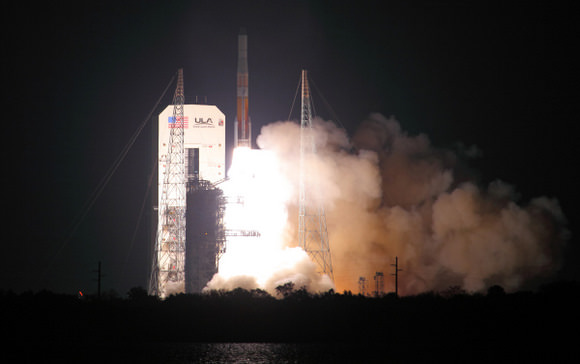
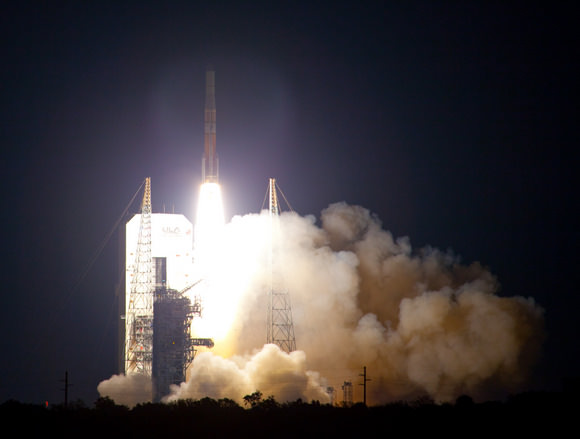
A Delta IV rocket rumbled and roared off launch pad 37B at Cape Canaveral Air Force Station in Florida Thursday evening, sending the GOES-P satellite soaring into a crisp and clear night sky. With liftoff at 6:57 p.m. EST, the rocket could be seen for several minutes after launch, and booster separation was clearly visible to observers on the NASA Causeway. The Geostationary Operational Environmental Satellite-P, or GOES-P, is the latest in a series of meteorological satellites designed to watch for storm development and weather conditions on Earth as well as detect hazards with its emergency beacon support and Search and Rescue Transponder. It will take ten days for the satellite to maneuver to its geostationary equatorial orbit at 35,888 km (22,300 miles). Once there, GOES-P will get a new name: GOES-15.
It will take five months for all the instruments on board to be tested and calibrated. After that, GOES-15 will be a back-up satellite, stored on-orbit and ready for activation should one of the operational GOES satellites degrade or exhaust their fuel.
The satellite is a cooperative effort between NASA and NOAA, the National Oceanic and Atmospheric Administration.
NOAA has two operational GOES satellites: GOES-12 in the east and GOES-11 in the west. Each provides continuous observations of environmental conditions in North, Central and South America and the surrounding oceans. GOES-13 is being moved to replace GOES-12, which will be positioned to provide coverage for South America as part of the Global Earth Observing System of Systems, or GEOSS.
Thanks to Alan Walters for great images of the launch.
On a personal note, I’ve now seen three different launches – each with a different launch vehicle — in just four weeks here at Kennedy Space Center (space shuttle Endeavour, SDO on Atlas and now GOES-P on the Delta IV.) KSC is a busy spaceport, indeed!
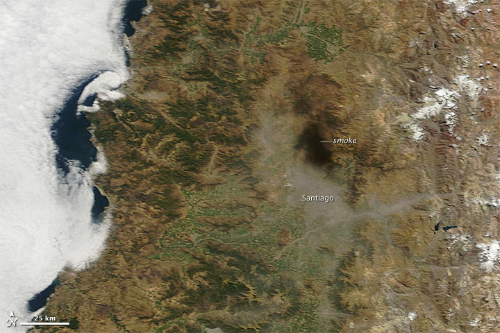
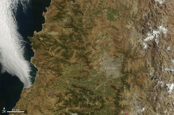
Haze lingered over the metropolitan area of Santiago, Chile, following a magnitude 8.8 earth quake on February 27, 2010. In an image from the Moderate Resolution Imaging Spectroradiometer (MODIS) on NASA’s Terra satellite at 14:25 UTC, black smoke hung over the northern part of the city, while light-colored haze (perhaps pollution and/or dust) covered the southern part of the city and filled a canyon that cuts eastward into the mountains. Below, in an image acquired on February 23, shows the city and surroundings under clear-sky conditions.
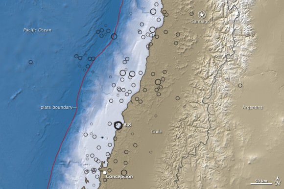
Below, a map of topography and water depth of the west coast of South America, which is a subduction zone, where the Nazca Plate is plowing under the South America Plate at an average rate of 80 millimeters (3 inches) per year. Their collision gives rise to the spectacular Andes Mountains as well as to devastating earthquakes. Lighter colors indicate higher elevation on land and shallower depth in the water. Quake locations and magnitudes are indicated by black circles. The topography is based on radar data collected during the Shuttle Radar Topography Mission, which flew onboard Space Shuttle Endeavour in mid-February 2002.
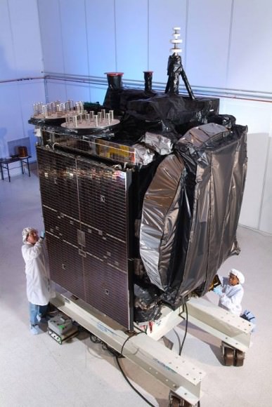
The final spacecraft in this series of NASA and NOAA’s “GOES” geostationary environmental weather satellites is ready for launch. GOES stands for Geostationary Operational Environmental Satellite, and in evidence that not all acronyms turn out for the best, this latest satellite in the series is GOES-P. But (to quote the Bad Astronomer) this satellite will be a whiz in helping to provide continuous observations of severe weather events on Earth and space weather, too, as well as providing an update to search and rescue capabilities. Once in orbit GOES-P’s name will change to GOES-15. “GOES are the backbone of NOAA’s severe weather forecasts, monitoring fast-changing conditions in the atmosphere that spawn hurricanes, tornadoes, floods and other hazards,” said Steve Kirkner, GOES program manager at NASA’s Goddard Space Flight Center.
Launch is targeted for March 2, during a launch window from 6:19 to 7:19 p.m. EST from Space Launch Complex 37 at the Cape Canaveral Air Force Station on a Delta IV rocket. Universe Today will be on location to provide coverage of all the launch and pre-launch activities. Follow Nancy on Twitter for live updates.
“The latest series of satellites, GOES- N, O, and P has new capabilities in space weather,” said Dr. Howard Singer from NOAA. “This is data that arrives almost instantaneously and therefore allows us to provide very timely alerts and warnings.”
But GOES-P will be a back-up satellite. Once launched, it will be checked out and then stored on-orbit and ready for activation should one of the operational GOES satellites degrade or exhaust their fuel. Currently, NOAA operates GOES-12, (GOES East) and GOES-11 (GOES-West.) In late April, NOAA will activate GOES-13 to replace GOES-12, and move GOES-12 to provide coverage for South America as part of the Global Earth Observing System of Systems (GEOSS). NASA handed over GOES-14, launched last June, to NOAA on December 14, 2009.
In addition to weather forecasting on Earth, a key instrument onboard GOES-P, the Solar X-Ray Imager (SXI), will help NOAA continue monitoring solar conditions.
“The SXI is improving our forecasts and warnings for solar disturbances, protecting billions of dollars worth of commercial and government assets in space and on the ground, and lessening the brunt of power surges for the satellite-based electronics and communications industry,” said Tom Bodgan, director of NOAA’s Space Weather Prediction Center (SWPC) in Boulder, Colo.
GOES P is the last in the series. The first GOES satellite was launched in 1975.
GOES-P joins a system of weather satellites that provide timely environmental information to meteorologists and the public. The GOES system provides data used to graphically display the intensity, path and size of storms. Early warning of impending severe weather enhances the public’s ability to take shelter and protect property.