First Galileo Satellite is in Orbit

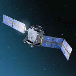
GIOVE-A deploys its solar arrays. Image credit: ESA . Click to enlarge
The first Galileo demonstrator is in orbit, marking the very first step to full operability of Europe’s new global navigation satellite system, under a partnership between ESA and the European Commission (EC).

Giove A, the first Galileo in-orbit validation element, was launched today from Baikonur, Kazakhstan, atop a Soyuz-Fregat vehicle operated by Starsem. Following a textbook lift-off at 05:19 UTC (06:19 CET), the Fregat upper stage performed a series of manoeuvres to reach a circular orbit at an altitude of 23 258 km, inclined at 56 degrees to the Equator, before safely deploying the satellite at 09:01:39 UTC (10:01:39 CET).

“Years of fruitful cooperation between ESA and the EC have now provided a new facility in space for improving the life of European citizens on Earth” said ESA Director General Jean Jacques Dordain congratulating ESA and industrial teams on the successful launch.

This 600 kg satellite, built by Surrey Satellite Technology Ltd (SSTL) of Guildford, in the UK, has a threefold mission. First, it will secure use of the frequencies allocated by the International Telecommunications Union (ITU) for the Galileo system. Second, it will demonstrate critical technologies for the navigation payload of future operational Galileo satellites. Third, it will characterise the radiation environment of the orbits planned for the Galileo constellation.

Formerly known as GSTB-V2/A (Galileo System Test Bed Version 2), Giove A carries two redundant, small-size rubidium atomic clocks, each with a stability of 10 nanoseconds per day, and two signal generation units, one able to generate a simple Galileo signal and the other, more representative Galileo signals. These two signals will be broadcast through an L-band phased-array antenna designed to cover all of the visible Earth under the satellite. Two instruments will monitor the types of radiation to which the satellite is exposed during its two year mission.

The satellite is under the control of SSTL’s own ground station. All systems are performing well, the solar arrays are deployed and in-orbit checkout of the satellite has begun. Once the payload is activated, the Galileo signals broadcast by Giove A will be carefully analysed by ground stations to make sure they satisfy the criteria of the ITU filings.

First step for Galileo

A second demonstrator satellite, Giove B, built by the European consortium Galileo Industries, is currently being tested and will be launched later. It is due to demonstrate the Passive Hydrogen Maser (PHM), which, with a stability better than 1 nanosecond per day, will be the most accurate atomic clock ever launched into orbit. Two PHMs will be used as primary clocks onboard the operational Galileo satellites, with two rubidium clocks serving as backups.

Subsequently, four operational satellites will be launched to validate the basic Galileo space and related ground segments. Once this In-Orbit Validation (IOV) phase is completed, the remaining satellites will be launched to achieve Full Operational Capability (FOC).

Galileo will be Europe’s own global navigation satellite system, providing a highly accurate, guaranteed global positioning service under civilian control. It will be inter-operable with the US Global Positioning System (GPS) and Russia’s Global Navigation Satellite System (Glonass), the two other global satellite navigation systems. Galileo will deliver real-time positioning accuracy down to the metric range with unrivaled integrity.

Numerous applications are planned for Galileo, including positioning and derived value-added services for transport by road, rail, air and sea, fisheries and agriculture, oil prospecting, civil protection activities, building, public works and telecommunications.

Original Source: ESA Portal

The Source of Killer Electrons

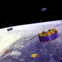
Artist’s illustration of ESA’s Cluster spacecraft floating above Earth. Image credit: ESA Click to enlarge
ESA’s Cluster mission has revealed a new creation mechanism of ‘killer electrons’ – highly energetic electrons that are responsible for damaging satellites and posing a serious hazard to astronauts.

Over the past five years, a series of discoveries by the multi-spacecraft Cluster mission have significantly enhanced our knowledge of how, where and under which conditions these killer electrons are created in Earth?s magnetosphere.

Early satellite measurements in the 1950s revealed the existence of two permanent rings of energetic particles around Earth.

Usually called the ‘Van Allen radiation belts’, they are filled with particles trapped by Earth’s magnetic field. Observations showed that the inner belt contains a fairly stable population of protons, while the outer belt is mainly composed of electrons in a more variable quantity.

Some of the outer belt electrons can be accelerated to very high energies, and it is these ‘killer electrons’ that can penetrate thick shielding and damage sensitive satellite electronics. This intense radiation environment is also a threat to astronauts.

For a long time scientists have been trying to explain why the number of charged particles inside the belts vary so much. Our major breakthrough came when two rare space storms occurred almost back-to-back in October and November 2003.

During the storms, part of the Van Allen radiation belt was drained of electrons and then reformed much closer to the Earth in a region usually thought to be relatively safe for satellites.

When the radiation belts reformed they did not increase according to a long-held theory of particle acceleration, called ‘radial diffusion’. Radial diffusion theory treats Earth’s magnetic field lines as being like elastic bands.

If the bands are plucked, they wobble. If they wobble at the same rate as the particles drifting around the Earth then the particles can be driven across the magnetic field and accelerated. This process is driven by solar activity.

Instead, a team of European and American scientists led by Dr Richard Horne of the British Antarctic Survey, Oxford, UK, used data from Cluster and ground receivers in Antarctica to show that very low frequency waves can cause the particle acceleration and intensify the belts.

These waves, named ‘chorus’, are natural electromagnetic emissions in the audio frequency range. They consist of discrete elements of short duration (less than one second) that sound like the chorus of birds singing at sunrise. These waves are among the most intense in the outer magnetosphere.

The number of ‘killer electrons’ can increase by a factor of a thousand at the peak of a magnetic storm and in the following days. Intense solar activity can also push the outer belt much closer to Earth, therefore subjecting lower altitude satellites to a much harsher environment than they were designed for.

The radial diffusion theory is still valid in some geophysical conditions. Before this discovery, some scientists thought that chorus emissions were not sufficiently efficient to account for the reformation of the outer radiation belt. What Cluster has revealed is that in certain highly disturbed geophysical conditions, chorus emissions are sufficient.

Thanks to the unique multipoint measurements capability of Cluster, the characteristic dimensions of these chorus source regions have been estimated for the first time.

Typical dimensions have been found to be a few hundred kilometres in the direction perpendicular to the Earth’s magnetic field and a few thousands of kilometres in the direction parallel to this.

However, the dimensions found so far are based on case studies. “Under disturbed magnetospheric conditions, the chorus source regions form long and narrow spaghetti-like objects. The question now is whether those very low perpendicular scales are a general property of the chorus mechanism, or just a special case of the analysed observations,” said Ondrej Santolik, of Charles University, Prague, Czech Republic, and main author of this result.

Due to our increased reliance on space based technologies and communications, the understanding of how, under which conditions and where these killer electrons are created, especially during magnetic storm periods, is of great importance.

Original Source: ESA Portal

Inmarsat-4 Blasts Off from Sea Launch

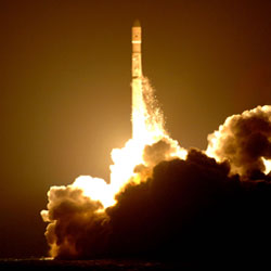
Zenit-3SL blasting off from the Odyssey Launch Platform. Image credit: Boeing. Click to enlarge.
Sea Launch Company today successfully delivered the Inmarsat-4 (I-4) communications satellite to geosynchronous transfer orbit (GTO). Early data indicate the spacecraft is in excellent condition.

A Zenit-3SL vehicle lifted off at 6:07 am PT (14:07 GMT), from the Odyssey Launch Platform, positioned at 154 degrees West Longitude. All systems performed nominally throughout the flight. The Block DM-SL upper stage inserted the 5,958 kg (13,108 lb.) satellite to geosynchronous transfer orbit, on its way to a final orbital position of 53 degrees West Longitude. A ground station at Lake Cowichan, in British Columbia, acquired the first signal from the satellite less than 25 minutes after spacecraft separation, as planned.

Inmarsat-4 is designed to provide high-speed mobile service to people throughout the Americas during its 13-year service life. It is one in a series of satellites designed to support the Broadband Global Area Network (BGAN) for high-speed delivery of Internet and intranet content and solutions, video-on-demand, videoconferencing, fax, e-mail, phone and LAN access. One of a family of three similar spacecraft, this Inmarsat-4 F2 satellite carries a single global beam that covers up to a third of the Earth’s surface, 19 wide spot beams and 228 narrow spot beams. It has a total end-of-life power of 13kW.

Following acquisition of the spacecraft’s signal, Jim Maser, president and general manager of Sea Launch, congratulated Inmarsat and EADS Astrium. “We have marked several milestones in this mission such as our first mission for Inmarsat and our first European-built spacecraft, and our successful mission is the most significant milestone of all! Our customer is satisfied that we have met all of their requirements,” Maser said. “Once again, we have done what we said we would do. We look forward to future missions with Inmarsat as well as with EADS Astrium. I want to thank every member of the Sea Launch team for making this mission success possible.”

Andrew Sukawaty, Chairman and Chief Executive of Inmarsat plc (LSE:ISAT), said, “We thank the team at Sea Launch for this innovative and highly professional launch. Years of preparation have come together. With the launch of our second I-4 satellite, we look forward to offering up to half megabit internet connection covering up to 90% of the Earth’s land mass – truly Broadband for a mobile planet.”

Sea Launch Company, LLC, headquartered in Long Beach, Calif., is the world’s most reliable heavy-lift commercial launch service. This international partnership offers the most direct and cost-effective route to geostationary orbit. With the advantage of a launch site on the Equator, the reliable Zenit-3SL rocket can lift a heavier spacecraft mass or provide longer life on orbit, offering best value plus schedule assurance. For additional information and images of this successfully completed mission, visit the Sea Launch website at: www.sea-launch.com

Original Source: Boeing News Release

Inmarsat Launch Delayed

Artist illustration of Inmarsat 4. Image credit: Inmarsat. Click to enlarge.
The launch Inmarsat-4 F2, one of the largest and most powerful communications satellites ever built has been reschedule for Tuesday 8 November.

The six-tonne UK-built craft is due to be lofted by a Zenit-3SL rocket from a floating platform in the Pacific Ocean. It should have flown on Saturday but a software glitch led to an automated halt in the countdown sequence. Flight controllers say they are now happy to go for a Tuesday launch after investigating the technical problem.

Lift-off is now scheduled at the opening of a 29-minute window at 1407 GMT. Inmarsat-4 F2 is the second of three satellites designed to improve global communications systems.

The first satellite, which covers most of Europe, Africa, the Middle East, Asia and the Indian Ocean, was launched from Cape Canaveral in March. The second will improve and extend communications across South America, most of North America, the Atlantic Ocean and part of the Pacific Ocean.

The two satellites will support the London-based sat-com Inmarsat company’s global broadband network, BGan.

Their onboard technology is designed to allow people to set up virtual offices anywhere around the world via high-speed broadband connections and new 3G phone technology. The spacecraft, each the size of a London bus, should continue functioning for about 15 years. They were built largely at the EADS-Astrium facilities in Stevenage and Portsmouth, UK.

The Inmarsat-4 F2 is going up from waters close to Kiritimati (Christmas Island) on the equator.

It is using the innovative Sea Launch system, which employs a converted oil drilling platform as a launch pad. It is towed into position from its California base.

Original Source: BNSC News Release

Power Problem with SSETI Express

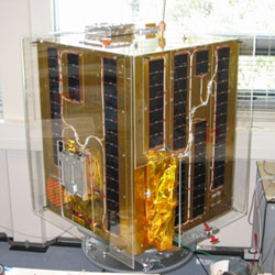
SSETI Express in construction. Image credit: ESA. Click to enlarge.
Since Friday morning, the ground control station in Aalborg has not had any contact with SSETI Express. Thorough analysis over the weekend indicates that a failure in the electrical power system on board the spacecraft is preventing the batteries from charging, resulting in a shutdown of the satellite. There is a small but significant possibility of recovery, the likelihood of which is being ascertained by ongoing testing.

“Naturally, the SSETI teams are disappointed that we lost contact, but the mission has still been a success from both an educational and a technical standpoint”, says Project Manager Neil Melville. “The main goal of the mission was to educate students by having them involved hands-on in all the different aspects of a space mission, and now we really have experienced everything”.

On top of the educational purpose, several of the operational goals were met in the time the satellite operated. All evidence suggests that the three CubeSat passengers were successfully deployed into orbit by SSETI Express, and were hence able to begin their own independent missions.

The CubeSats Xi-V and UWE-1 are alive and well, the status of NCube-2 has yet to be confirmed. Stable two-way communications between the groundstation and SSETI Express was established and both the Aalborg University as well as many radio amateurs all over the world downloaded a significant amount of housekeeping data.

Currently, the student teams continue to investigate the situation and assess the chances of recovery. “Even if we don’t recover contact with SSETI Express, it was still a very worthwhile mission for everyone. We will take many lessons learned on to our next educational satellite project, SSETI ESEO”, says Roger Elaerts, ESA’s Head of Education Department.

Original Source: ESA News Release

Launcher Caused Cryosat Failure

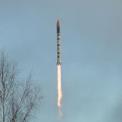
Russian Rokot carrying the Cryosat satellite. Image credit: ESA. Click to enlarge.
Following the failure of the Rockot launch vehicle during the CryoSat mission on 8 October 2005, the Russian Failure Investigation State Commission led by the Space Forces Deputy Commander Oleg Gromov announced the clearance of the launch vehicle for future use including launches for the Russian Ministry of Defence.

According to the analysis of the State Commission, the reason for the failure has been unambiguously identified: The failure occurred when the flight control system in the Breeze upper stage did not generate the command to shut-down the second stage’s engines. A set of measures is now being implemented to prevent a re-occurrence of the incident.

A detailed briefing of the findings of the State Commission to Eurorocket and its customer ESA will take place on 3 November 2005. A Eurorockot Failure Review Board will review the conclusions of the State Commission and will release its findings in the near future.

Original Source: ESA News Release
Student-Built Satellite Launches

Kosmos 3M launcher blasting off. Image credit: ESA. Click to enlarge.
SSETI Express, a low Earth orbit spacecraft designed and built by European university students under the supervision of ESA’s Education Department, was successfully launched this morning at 08:52 CEST from the Plesetsk Cosmodrome on a Russian Kosmos 3M launcher. At 10:29 CEST this morning, the ground control centre at the University in Aalborg (DK) received the first signals from the satellite.

SSETI Express (SSETI being the acronym for Student Space Exploration and Technology Initiative) is a small spacecraft, similar in size and shape to a washing machine (approx. 60×60 x90 cm). Weighing about 62 kg it has a payload of 24 kg. On-board the student-built spacecraft were three pico-satellites, extremely small satellites weighing around one kg each. These were deployed one hour and 40 minutes after launch. In addition to acting as a test bed for many designs, including a cold-gas attitude control system, SSETI Express will also take pictures of the Earth and function as a radio transponder.

The challenge has been for the 23 university groups, working from locations spread across Europe and with very different cultural backgrounds, to work together via the Internet to jointly build the satellite.

The Student Space Exploration and Technology Initiative, which provides the framework for the mission, was launched by ESA’s Education Department in 2000 to get European students involved in real space missions. The initiative aims at giving students practical hands-on experience and encourage them to take up careers in space technology and science, thereby helping to create a pool of talented experts for the future.

Since its creation, SSETI has developed a network of students, educational institutions and organisations to facilitate work on various spacecraft projects. More than 400 European students have made an active, long-term contribution to this initiative, either as part of their degree course or in their spare time. In addition, many hundreds more have been involved in or inspired by SSETI.

SSETI students are currently working on two other satellite projects:

* SSETI ESEO: The European Student Earth Orbiter, a 120kg spacecraft designed for Ariane 5, planned for launch in 2008.
* A study for a European Student Moon Orbiter – timeframe 2010-2012. The orbiter will conduct experiments on its way to the Moon as well as when lunar orbit is achieved.

Original Source: ESA News Release
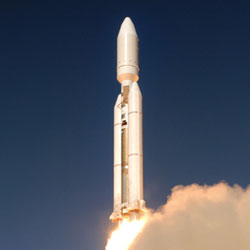
Final Titan 4 Launches

Final Titan 4 lifting off. Image credit: Lockheed Martin. Click to enlarge.
The United States Air Force and Lockheed Martin (LMT:NYSE) closed out a proud five-decade history today with the final launch of a Titan IV B rocket carrying a critical national security payload for the National Reconnaissance Office (NRO). All eyes were on Space Launch Complex 4 East as the nation’s heavy-lift workhorse thundered off the pad to deliver its final payload to space and retire from service.

“Today’s spectacular launch is a fitting way to say goodbye to Titan,” said G. Thomas Marsh, executive vice president of Lockheed Martin Space Systems Company. “The Lockheed Martin employees who have given their utmost efforts to the program over the years join with our Air Force and NRO customers, and the many other organizations that make up the Titan team, in expressing our great pride in this service to our country’s space program.”

Today’s launch was the last launch for the Titan IV and the culmination of a long evolution from the original Titan I intercontinental ballistic missile. In all, 39 Titan IVs have been launched – 12 Titan IVs have been launched from Vandenberg Air Force Base on the West Coast plus 27 more from the Cape Canaveral Air Force Station, Fla. The final Titan IV mission from Cape Canaveral was launched successfully April 29, 2005.

Col. Michael T. Baker, director, Launch Programs, Space and Missile Systems Center, Air Force Space Command, said, “The members of the System Program Office are extremely proud to be part of this historic launch. I am particularly honored to lead this SPO since Titan has been a part of my career since 1981. We have been confident from the beginning that the Titan team would deliver one final mission success for the nation.”

Following the Space Shuttle Challenger tragedy in 1986, when assured access to space became critical for the U.S. government, the Titan IV was developed as the booster used to launch the nation’s largest, heaviest and most critical payloads. Titan initial IV A design was followed by Titan IV B with a new generation of large solid rocket motors, state-of-the-art guidance and electronics and a new ground processing system.

“Today’s launch marks the end of an NRO Titan era but the beginning of the Titan Legend that will live on in the history of America’s space program,” said Col. Chip Zakrzewski, National Reconnaissance Office mission director.

Lockheed Martin Space Systems Company built the Titan IVs near Denver, Colo., under contract to the U.S. government. As prime contractor and systems integrator, the company built the first and second stages and provides overall program management and launch services. Other members of the Titan IV contractor team and their responsibilities include: GenCorp Aerojet Propulsion Division, Sacramento, Calif., liquid rocket engines; Alliant Techsystems, Magna, Utah, solid rocket motor upgrade; The Boeing Company, Huntington Beach, Calif., payload fairing; and Honeywell Space Systems, Clearwater, Fla., advanced guidance.

Original Source: Lockheed Martin News Release

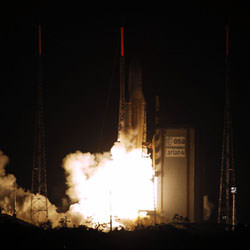
Ariane Rocket Blasts Off with Two Satellites

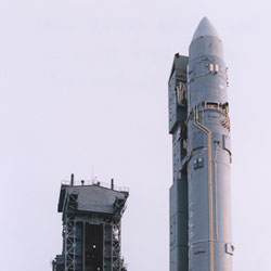
Ariane 5 rocket with two satellites on board. Image credit: ESA. Click to enlarge.
Just after midnight an Ariane 5GS successfully lifted off from Europe?s Spaceport in French Guiana. The two solid boosters ignited 7 seconds after the start-up of the cryogenic main stage, providing the power needed to lift the heavy launcher off the pad.

On board was a Syracuse 3A, built by Alcatel Alenia Space for the French Ministry of Defence and a Galaxy 15 communications satellite built by Orbital Sciences Corporation, USA, for the American company PanAmSat. Galaxy 15 is the 20th satellite to be launched by Ariane launchers for this satellite communications operator.

On arriving at orbital injection, around 26 minutes after launch, the Ariane 5 was at an altitude of about 1560 km and travelling at approximately 8633 metres a second. Syracuse 3A was the first satellite to be released, followed approximately 10 minutes later by the Galaxy 15. Both satellites have been placed in the targeted geostationary transfer orbit with very high precision.

Flight 168 is the 23rd Ariane 5 launch.

Original Source: ESA News Release
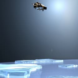
ESA’s CryoSat is Ready for Launch

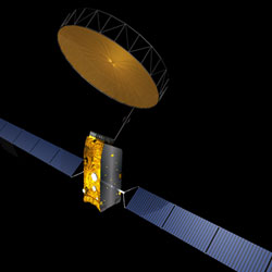
Artist’s illustration of Cryosat. Image credit: ESA. Click to enlarge.
The expectations of ice researchers across Europe are currently focused on a region of taiga woodland in Russia’s far north. Located in a forest clearing is Pad LC133 of Plesetsk Cosmodrome, where above the tree-line on a Rockot launcher stands ESA’s CryoSat satellite, due to start its flight into orbit this Saturday at 17:02 CEST.

The first of ESA’s Earth Explorer series – missions tailored to respond to particular needs of the Earth science community – CryoSat will use a specialised radar altimeter to measure changes in land and sea ice thickness over a three-year period, to provide a precise picture of how the Polar Regions are responding to climate change.

The generation of radar altimeters currently flying on satellites including ERS-2 and Envisat have made a large contribution to our knowledge of the mass balance of Greenland and Antarctic ice sheets, but they cannot return reliable data from the ice edge, where the rate of change is greatest. Similarly, over the ocean their resolution is insufficient to detect the majority of individual pack ice pieces. The design of CryoSat’s new SAR Interferometric Radar Altimeter (SIRAL) has been optimised to close these data gaps.

Many European ice specialists have played a part in the preparation for the mission, either through participation in the CryoSat Science Advisory Group, taking part in extensive in-situ calibration and validation activities in the Arctic and Antarctic, or preparing processing algorithms to turn raw altimetry results into usable information products. And whether or not they have made such direct contributions, researchers are eagerly awaiting the unique results CryoSat will return.

“Summer Arctic sea ice is shrinking ? but is it thinning?”
Dr Seymour Laxon of the Centre for Polar Modelling (CPOM) at University College London has been part of the mission with the start ? working closely with Lead Investigator Professor Duncan Wingham from the original mission proposal to ESA onwards.

“At that time we had just managed to extract the first plausible sea ice thickness maps from the radar altimeter on ESA’s ERS,” Dr. Laxon remembers. “Coupled with Duncan’s experience in mapping the ice sheets, ESA’s Earth Explorer Opportunity programme seemed like a great chance for us to build on what we had learned from the earlier ESA missions to design a mission that was really focused on altimetry over ice.”

A period of concentrated effort followed, as findings from past exploratory studies, and the latest results from ERS, were converted into a proposal for a new mission that could better those results.

“I vividly remember the selection procedure, with Duncan reporting back at each selection stage that CryoSat was still in the running,” Dr. Laxon adds. “I don’t think either of us were quite ready to hear the news that CryoSat was the first to be selected.

“At that point we both realised that the real work, to build a complete mission scenario from scratch, had started. Now everything is in place, the satellite sitting on top of its launcher, the processing system for the data, and plans for the post-launch validation campaign. Now we are just looking forward to seeing the very first data.”

In terms of his own area of interest, it is the sea ice data that Dr. Laxon is most looking forward to: “The most exciting thing for me is the prospect of seeing the first maps of sea ice thickness from CryoSat. We have not seen estimates of Arctic sea ice thickness around the North Pole since the last submarine data from 1999 were declassified.”

“Back then, analysis of this data suggested that a significant ? up to 40% – thinning had occurred since the 1960s, with the largest thinning around the pole. The big question is whether that thinning has reversed or continued as we have entered the new century.”

“That question has gained even more impetus since the news that the extent of summer ice in the Arctic has reached a record minimum this year. But has it also thinned? That’s the crucial question to which CryoSat will provide the answer.”

Opening a new window on the Poles
Professor Chris Rapley is Director of the Cambridge-based British Antarctic Survey and is also Chair of the Planning Group for the forthcoming International Polar Year, which will take place in 2007-8, during the time CryoSat will be carrying out its ice thickness survey. He has had a long involvement with radar altimetry over ice.

Prof. Rapley states: “I was deeply involved in the preparations for the ESA ERS and Envisat altimeters, and led or contributed to a substantial series of studies commissioned by ESA to explore the use of satellite radar altimeters over polar land ice and sea ice, and the technical advances required in instruments, data processing and analysis software to achieve useful scientific results.”

That activity included work on designing and implementing the UK-based ERS processing and archiving facility and the ESA altimeter data processing chain and associated software. Prof. Rapley also worked on design studies for more advanced altimeters along CryoSat’s lines.

A past member of ESA’s Earth Observation Advisory Committee (ESAC), Prof. Rapley was also involved in reviewing the CryoSat proposal and its adoption as an ESA Earth Explorer.

“What I am looking forward to is the best measure yet of the Antarctic and Greenland ice sheet mass balance,” Prof. Rapley adds. “CryoSat should also open a new window on the nature, geographic distribution and the seasonal/systematic behaviour of Antarctic and Arctic sea ice.”

“We can add ice thickness to our models”
Direct in-situ observations of land and sea ice have been necessary to establish that the CryoSat sensor will indeed ‘see’ as anticipated, and quantify residual geophysical uncertainties. As a member of ESA’s CryoSat Cal/Val Team, Dr. Christian Haas of the Alfred Wegener Institute in Bremerhaven coordinates German activities in this area.

“I lead the German CryoSat office,” says Dr. Haas. “It is the main interface between German users and scientists involved in Cryosat and ESA. We are also raising money in Germany for work with CryoSat.

“I am also coordinating the sea ice validation work in the Arctic and Antarctic. We at the Alfred Wegener Institute are the only group able to measure sea ice thickness directly, by helicopter-borne electromagnetic measurements with our EM-bird sensor. We have conducted the CryoVex (CryoSat Validation Exercise) campaign in 2003 and this year’s Bay of Bothnia campaign.”

As a geophysicist, Dr. Haas has been working with sophisticated software models of sea ice. Results from CryoSat will be used to first to check these models, then later be directly ingested within them to bring them closer to reality. The satellite’s ice thickness data in particular should literally add a new dimension to their representation of polar sea ice.

“As a scientist I am interested in using CryoSat data for validating our sea ice models, and combining the data with other met-ocean data to better understand the variability of sea ice thickness,” Haas explains. “We also want to assimilate sea ice thickness into our models.”

After CryoSat’s launch comes a further validation campaign, to compare the results from space to the reality on ground, as Haas adds: “I am looking forward to the validation of the satellite, and the opportunity of extending our airborne measurements laterally by means of the satellite.

Is Antarctic land ice growing or shrinking?
Other researchers, such as Dr. Massimo Frezzotti of Italy’s National Agency for New Technologies, Energy and the Environment (ENEA) in Rome hope to use the new satellite’s results to improve their knowledge of ice sheets on land.

Dr. Frezzotti has carried out in-situ studies of the Antarctic ice sheet between the Italian base of Terra Nova Bay on the shores of the Ross Sea and the new Franco-Italian Concordia base high on the Antarctic Plateau some 1200 kilometres inland. He also makes use of altimetry results in his research.

“I already use ERS altimeter data to study the influence of wind erosion on surface mass balance,” Dr. Frezzotti explains. “Previous altimeters are not able to provide a detailed model of the coastal areas, which are a very crucial area for mass balance studies. CryoSat will partially cover this gap.”

Satellite altimetry observations over the ocean have established a steady rise in global sea level of an average 0.3 millimetres a year. What is not known ? yet ? is how changes in polar ice thickness may be contributing to this trend.

“The Antarctic ice sheet contains sufficient ice to raise worldwide sea level by more than 60 metres if melted completely,” Dr. Frezzotti adds. “The amount of snow deposited annually on its surface is equivalent to five or six millimetres of global sea level. Thus the ice sheet could be a major source of water for the present-day rise in sea level, but the uncertainty is still large.

“Despite all available measurements of snow accumulation, ice velocity, surface and basal melting and iceberg discharge, it is still not known for certain even whether the ice sheet is growing or shrinking.” CryoSat should remedy this state of affairs.

Determining CryoSat’s orbit will improve its results
The Department of Earth Observation and Space Systems (DEOS) of the Delft University of Technology has an interest in the precise orbit determination (POD) of radar altimeter satellites. Because altimetry is based on the principle that time equals distance ? measuring how long it takes for a radar pulse to travel back from the Earth’s surface to the spacecraft – more exact knowledge of the satellite’s location at any one time greatly improves the quality and accuracy of the final data.

CryoSat has two onboard instruments for sharpening orbital estimates from a matter of metres down to a maximum three centimetres ? the Doppler Orbitography and Radiopositioning Integrated by Satellite (DORIS) radio receiver and a Laser Retro-reflector (LRR). Both these devices are found on a number of different satellites, and work based on global networks of radio transmitters and laser stations.

In addition a satellite trajectory prediction model will be created by DEOS to forecast how CryoSat’s orbit will be perturbed by the slight pressure of sunlight and the drag of the upper atmosphere as well as gravitational tugs from terrestrial gravity field anomalies as well as the influence of the tides, other planets and our Sun.

“We will determine CryoSat’s orbit, but in addition we will also perform cal/val activities for its SIRAL instrument, particularly in the Low-Rate Mode (LRM) over the open ocean and inland ice sheets,” said Dr. Ernst Schrama. “Comparing LRM sea surface results to in-situ buoys and tidal gauges should enable a means of externally validating LRM results.?

“We will also add CryoSat data to our Radar Altimeter Database System (RADS) compiled from other current as well as past altimeter missions. The database will be used to inter-compare the performance of SIRAL against other altimeters.”

Beyond improving the quality of CryoSat results, RADS also represents a scientific resource in its own right, which provides a continuous set of sea level measurements of constant quality. RADS can be used for scientific and operational oceanography as well as detecting slight variations in the Earth’s gravity field to infer its interior structure.

Original Source: ESA News Release