Iapetus in Dark and Light

Saturn’s moon Iapetus. Image credit: NASA/JPL/SSI. Click to enlarge
Cassini captured these images of Saturn’s moon Iapetus, with opposing bright and dark hemispheres. The dark terrain extends from the equator to the mid southern regions, and then becomes more patchy leading to its bright south pole. Cassini took this photograph on April 9, 2006, at a distance of approximately 692,000 kilometers (430,000 miles) from Iapetus.

Cassini’s landmark investigation of Saturn’s yin-yang moon Iapetus, with its bright and dark hemispheres, continues to provide insights into the nature of this intriguing body.

These two views of Iapetus primarily show terrain in the southern part of the moon’s dark leading hemisphere — the side of Iapetus that is coated with dark material. The bright south pole of Iapetus is visible, along with some terrain (at the bottom) that lies on the bright trailing hemisphere.

The dark terrain known as Cassini Regio is uniformly dark between the equator and about 30 degrees south latitude. From there down to about 50 to 60 degrees south latitude, the dark material looks “patchy” because south-facing crater walls are bright (being largely devoid of the dark material). South of this region, only some northward-facing crater walls are still dark, while the bright terrain has a somewhat reddish color.

See Dark-stained Iapetus for an up-close view of this transition in the northern hemisphere.

Beyond 90 degrees south (i.e., on the trailing side), the reddish color becomes white. The region at the bottom of the color view presented here shows this “color boundary” in the bright terrain, which also marks the boundary between the leading and trailing hemispheres.

Iapetus is 1,468 kilometers (912 miles) across. North is up in the monochrome image and rotated 16 degrees to the left in the color image.

The monochrome image on the left was taken using a filter sensitive to wavelengths of infrared light centered at 930 nanometers. The image was obtained with the Cassini spacecraft narrow-angle camera on April 8, 2006, at a distance of approximately 866,000 kilometers (538,000 miles) from Iapetus and at a Sun-Iapetus-spacecraft, or phase, angle of 88 degrees. The image scale is 5 kilometers (3 miles) per pixel.

The color view on the right was created by combining images taken in ultraviolet, green and infrared spectral filters. The images were acquired with the Cassini spacecraft narrow-angle camera on April 9, 2006, at a distance of approximately 692,000 kilometers (430,000 miles) from Iapetus and at a Sun-Iapetus-spacecraft, or phase, angle of 101 degrees. The image scale is 4 kilometers (2.5 miles) per pixel.

The Cassini-Huygens mission is a cooperative project of NASA, the European Space Agency and the Italian Space Agency. The Jet Propulsion Laboratory, a division of the California Institute of Technology in Pasadena, manages the mission for NASA’s Science Mission Directorate, Washington, D.C. The Cassini orbiter and its two onboard cameras were designed, developed and assembled at JPL. The imaging operations center is based at the Space Science Institute in Boulder, Colo.

For more information about the Cassini-Huygens mission visit http://saturn.jpl.nasa.gov . The Cassini imaging team homepage is at http://ciclops.org .

Original Source: NASA/JPL/SSI News Release

Three Storms on Saturn

Three big vortices swirling through Saturn’s southern latitudes. Image credit: NASA/JPL/SSI. Click to enlarge
Three giant storms swirl across the atmosphere of Saturn in this photograph taken by Cassini – the two in the upper part of the photo appear to be interacting. This image was taken by Cassini on April 15 when the spacecraft was approximately 3.9 million kilometers (2.4 million miles) from Saturn.

Three large and impressive vortices, including two that appear to be interacting, are captured here as they swirl through Saturn’s active southern latitudes.

This view shows latitudes slightly to the north of those seen in Round and Round They Go and was taken a few minutes prior to the left side image in that release.

The image was taken with the Cassini spacecraft narrow-angle camera using a spectral filter sensitive to wavelengths of infrared light centered at 750 nanometers. The image was acquired on April 15, 2006, at a distance of approximately 3.9 million kilometers (2.4 million miles) from Saturn. The image scale is 23 kilometers (14 miles) per pixel.

The Cassini-Huygens mission is a cooperative project of NASA, the European Space Agency and the Italian Space Agency. The Jet Propulsion Laboratory, a division of the California Institute of Technology in Pasadena, manages the mission for NASA’s Science Mission Directorate, Washington, D.C. The Cassini orbiter and its two onboard cameras were designed, developed and assembled at JPL. The imaging operations center is based at the Space Science Institute in Boulder, Colo.

For more information about the Cassini-Huygens mission visit http://saturn.jpl.nasa.gov . The Cassini imaging team homepage is at http://ciclops.org .

Original Source: NASA/JPL/SSI News Release

Iapetus’ Darker Side

Saturn’s moon Iapetus. Image credit: NASA/JPL/SSI. Click to enlarge
This Cassini image shows the darker side of Saturn’s moon Iapetus. Scientists aren’t sure why, but Iapetus’ leading hemisphere is much darker than its trailing hemisphere. At the top of the image, it’s possible to see a large impact basin 400 km (250 miles) wide. Cassini took this photograph on April 4, 2006, at a distance of approximately 1.4 million kilometers (900,000 miles) from Iapetus.

A distant glimpse of Iapetus reveals details within the dark terrain of Cassini Regio, including an impact basin at top that is roughly 400 kilometers (250 miles) wide.

Researchers remain unsure about the mechanism that has darkened the leading hemisphere.

This view looks toward the southern hemisphere on the leading side of Iapetus (1,468 kilometers, or 912 miles across). North is up.

The image was taken in visible light with the Cassini spacecraft narrow-angle camera on April 4, 2006, at a distance of approximately 1.4 million kilometers (900,000 miles) from Iapetus. The image scale is 9 kilometers (6 miles) per pixel.

The Cassini-Huygens mission is a cooperative project of NASA, the European Space Agency and the Italian Space Agency. The Jet Propulsion Laboratory, a division of the California Institute of Technology in Pasadena, manages the mission for NASA’s Science Mission Directorate, Washington, D.C. The Cassini orbiter and its two onboard cameras were designed, developed and assembled at JPL. The imaging operations center is based at the Space Science Institute in Boulder, Colo.

For more information about the Cassini-Huygens mission visit http://saturn.jpl.nasa.gov . The Cassini imaging team homepage is at http://ciclops.org .

Original Source: NASA/JPL/SSI News Release

Titan and Epimetheus

Epimetheus and Titan against Saturn’s rings. Image credit: NASA/JPL/SSI Click to enlarge
This Cassini photograph shows Saturn’s rings and two of its moons: Titan and Epimetheus. Saturn’s A and F rings are visible in this photograph, and the darker region is the 325 km (200 mile) -wide Encke gap. This image was taken on April 28, 2006 when Cassini was approximately 667,000 kilometers (415,000 miles) from Epimetheus and three times that distance to Titan.

The Cassini spacecraft delivers this stunning vista showing small, battered Epimetheus and smog-enshrouded Titan, with Saturn’s A and F rings stretching across the scene.

The prominent dark region visible in the A ring is the Encke Gap, in which the moon Pan and several narrow ringlets reside. Moon-driven features that mark the A ring are easily seen to the left and right of the Encke Gap. The Encke Gap is 325 kilometers (200 miles) wide. Pan is 26 kilometers (16 miles) across.

In an optical illusion, the narrow F ring, outside the A ring, appears to fade across the disk of Titan. A couple of bright clumps can be seen in the F ring.

Epimetheus is 116 kilometers (72 miles) across and giant Titan is 5,150 kilometers (3,200 miles) across.

The image was taken in visible light with the Cassini spacecraft narrow-angle camera on April 28, 2006, at a distance of approximately 667,000 kilometers (415,000 miles) from Epimetheus and 1.8 million kilometers (1.1 million miles) from Titan. The image captures the illuminated side of the rings. The image scale is 4 kilometers (2 miles) per pixel on Epimetheus and 11 kilometers (7 miles) per pixel on Titan.

The Cassini-Huygens mission is a cooperative project of NASA, the European Space Agency and the Italian Space Agency. The Jet Propulsion Laboratory, a division of the California Institute of Technology in Pasadena, manages the mission for NASA’s Science Mission Directorate, Washington, D.C. The Cassini orbiter and its two onboard cameras were designed, developed and assembled at JPL. The imaging operations center is based at the Space Science Institute in Boulder, Colo.

For more information about the Cassini-Huygens mission visit http://saturn.jpl.nasa.gov . The Cassini imaging team homepage is at http://ciclops.org .

Original Source: NASA/JPL/SSI News Release

Titan’s Sandy Oceans

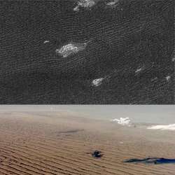
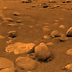
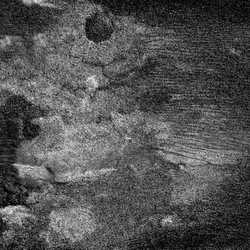
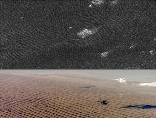
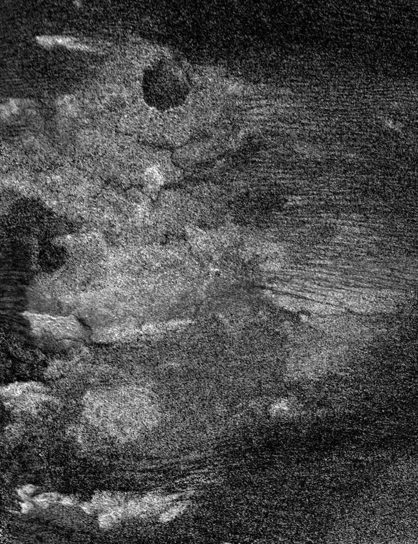
Titan’s sand dunes. Image credit: NASA/JPL. Click to enlarge
When they first noticed the dark equatorial regions on Titan, researchers thought they could be looking at oceans of liquid methane. But new radar images taken by NASA’s Cassini spacecraft has provided the answer: sand dunes. The images show enormous dunes that run parallel to each other for hundreds of kilometers. Saturn’s powerful gravity causes gentle winds on Titan, possibly transporting sand from across the moon and depositing it around the equator.

Until a couple of years ago, scientists thought the dark equatorial regions of Titan might be liquid oceans.

New radar evidence shows they are seas — but seas of sand dunes like those in the Arabian or Namibian Deserts, a University of Arizona member of the Cassini radar team and colleagues report in Science (May 5).

Radar images taken when the Cassini spacecraft flew by Titan last October show dunes 330 feet (100 meters) high that run parallel to each other for hundreds of miles at Titan’s equator. One dune field runs more than 930 miles (1500 km) long, said Ralph Lorenz of UA’s Lunar and Planetary Laboratory.

“It’s bizarre,” Lorenz said. “These images from a moon of Saturn look just like radar images of Namibia or Arabia. Titan’s atmosphere is thicker than Earth’s, its gravity is lower, its sand is certainly different — everything is different except for the physical process that forms the dunes and resulting landscape.”

Ten years ago, scientists believed that Saturn’s moon Titan is too far from the sun to have solar-driven surface winds powerful enough to sculpt sand dunes. They also theorized that the dark regions at Titan’s equator might be liquid ethane oceans that would trap sand.

But researchers have since learned that Saturn’s powerful gravity creates significant tides in Titan’s atmosphere. Saturn’s tidal effect on Titan is roughly 400 times greater than our moon’s tidal pull on Earth.

As first seen in circulation models a couple of years ago, Lorenz said, “Tides apparently dominate the near-surface winds because they’re so strong throughout the atmosphere, top to bottom. Solar-driven winds are strong only high up.”

The dunes seen by Cassini radar are a particular linear or longitudinal type that is characteristic of dunes formed by winds blowing from different directions. The tides cause wind to change direction as they drive winds toward the equator, Lorenz said.

And when the tidal wind combines with Titan’s west-to-east zonal wind, as the radar images show, it creates dunes aligned nearly west-east except near mountains that influence local wind direction.

“When we saw these dunes in radar it started to make sense,” he said. “If you look at the dunes, you see tidal winds might be blowing sand around the moon several times and working it into dunes at the equator. It’s possible that tidal winds are carrying dark sediments from higher latitudes to the equator, forming Titan’s dark belt.”

The researchers’ model of Titan suggests tides can create surface winds that reach about one mile per hour (a half-meter per second). “Even though this is a very gentle wind, this is enough to blow grains along the ground in Titan’s thick atmosphere and low gravity,” Lorenz said. Titan’s sand is a little coarser but less dense than typical sand on Earth or Mars. “These grains might resemble coffee grounds.”

The variable tidal wind combines with Titan’s west-to-east zonal wind to create surface winds that average about one mile per hour (a half meter per second). Average wind speed is a bit deceptive, because sand dunes wouldn’t form on Earth or Mars at their average wind speeds.

Whether the grains are made of organic solids, water ice, or a mixture of both is a mystery. Cassini’s Visual and Infrared Mapping Spectrometer, led by UA’s Robert Brown, may get results on sand dune composition.

How the sand formed is another peculiar story.

Sand may have formed when liquid methane rain eroded particles from ice bedrock. Researchers previously thought that it doesn’t rain enough on Titan to erode much bedrock, but they thought in terms of average rainfall.

Observations and models of Titan show that clouds and rain are rare. That means that individual storms could be large and still yield a low average rainfall, Lorenz explained.

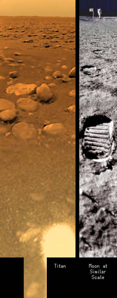
When the UA-led Descent Imager/Spectral Radiometer (DISR) team produced images taken during the Huygens probe landing on Titan in January 2005, the world saw gullies, streambeds and canyons in the landscape. These same features on Titan have been seen with radar.

These features show that when it does rain on Titan, it rains in very energetic events, just as it does in the Arizona desert, Lorenz said.

Energetic rain that triggers flash floods may be a mechanism for making sand, he added.

Alternatively, the sand may come from organic solids produced by photochemical reactions in Titan’s atmosphere.

“It’s exciting that the radar, which is mainly to study the surface of Titan, is telling us so much about how winds on Titan work,” Lorenz said. “This will be important information for when we return to Titan in the future, perhaps with a balloon.”

An international group of scientists are co-authors on the Science article, “The Sand Seas of Titan: Cassini Observations of Longitudinal Dunes.” They are from the Jet Propulsion Laboratory, California Institute of Technology, U.S. Geological Survey – Flagstaff, Planetary Science Institute, Wheeling Jesuit College, Proxemy Research of Bowie, Md., Stanford University, Goddard Institute for Space Studies, Observatoire de Paris, International Research School of Planetary Sciences, Universita’ d’Annunzio, Facolt di Ingegneria, Universit La Sapienza, Politecnico di Bari and Agenzia Spaziale Italiana. Jani Radebaugh and Jonathan Lunine of UA’s Lunar and Planetary Laboratory are among the co-authors.

The Cassini-Huygens mission is a cooperative project of NASA, the European Space Agency and the Italian Space Agency. The Jet Propulsion Laboratory, a division of the California Institute of Technology in Pasadena, manages the mission for NASA’s Science Mission Directorate, Washington. The Cassini orbiter was designed, developed and assembled at JPL.

Original Source: UA News Release

Measuring a Day on Saturn

Dreamy colours of Saturn. Image credit: NASA/JPL/SSI. Click to enlarge
With solid planets, like the Earth and Mars, it’s easy to track the length of their days. Just watch for a surface feature to rotate into view again. With gas giants, however, it’s a tricky business. Scientists have used features of Saturn’s magnetic field to act like objects on its surface; tracking the amount of time it takes for that point in the magnetic field to rotate around again. Cassini has determined that Saturn’s day is 10 hours, 47 minutes, 6 seconds (+- 40 seconds).

We all know Earth rotates every 24 hours, but scientists have long had difficulty pinpointing how long the day is on Saturn. The magnetometer onboard the Cassini spacecraft has, for the first time ever, measured a periodic signal in Saturn’s magnetic field, key information to finally understanding the length of a Saturn day and the evolution of this gaseous planet.

The latest research suggests a Saturn day is 10 hours, 47 minutes, 6 seconds (plus or minus 40 seconds). That’s 8 minutes slower than NASA Voyager results from the early 1980s, and slower than previous estimates from another Cassini instrument. The magnetometer results provide the best estimate of the Saturn day to date, because it can see deep inside Saturn. These Cassini results are in the May 4 issue of the journal Nature.

“Measuring the rotation period of a rocky planet like Earth is easy, but measurements for planets made of gas, such as Saturn, pose problems,” said the lead author of the paper, Dr. Giacomo Giampieri, a researcher at NASA’s Jet Propulsion Laboratory, Pasadena, Calif.

Planets rotate around their “spin” axes as they orbit about the sun. Rocky planets like Earth and Mars have rotation periods that are easy to measure because we can see surface features as they go by, such as the continents as viewed from space. Gaseous planets do not have a solid surface to track.

The magnetic field is generated deep inside Saturn’s liquid metallic core by flowing electric currents. By measuring the field, researchers can determine the length of the day on Saturn.

“Making this measurement has been one of the most important science goals for the mission,” said Professor Michele Dougherty of Imperial College London. “Finding a distinct periodic rhythm in the magnetic field helps us understand the internal structure of Saturn that in turn will help us understand how it formed.”

Knowing the length of a day or how fast the planet rotates is critical to understanding the internal structure of the planet and modelling the weather patterns on Saturn.

On approach to Saturn, Cassini’s radio and plasma wave instrument measured radio signals and predicted that the day on Saturn was 10 hours, 45 minutes, 45 seconds. That was considered a very good estimate at the time.

Since the Voyager days scientists have been seeing changes in the period of radio observations. They knew that it was virtually impossible to slow down or speed up a mass as large as Saturn. As Cassini’s measurements of the rhythms of natural radio signals from the planet continued to vary, scientists began to realize these signals were probably not a direct measurement of the internal rotation rate. Suddenly the length of Saturn’s day became uncertain. Measurements of the magnetic field help scientists “see” deep inside Saturn and may have finally solved this puzzle.

“Our magnetic field measurements have remained constant since Cassini entered orbit almost two years ago, while radio measurements since the Voyager era have shown large variability. By monitoring the magnetic field over the rest of the mission, we will be able to solve this puzzle,” Giampieri.

In addition to Giampieri the other authors are: Michele Dougherty, from Imperial College, London; Edward Smith also from JPL; and Christopher Russell from the University of California, Los Angeles.

The Cassini-Huygens mission is a cooperative project of NASA, the European Space Agency and the Italian Space Agency. The Jet Propulsion Laboratory, a division of the California Institute of Technology in Pasadena, manages the Cassini-Huygens mission for NASA’s Science Mission Directorate, Washington. The Cassini orbiter was designed, developed and assembled at JPL. The magnetometer team is based at Imperial College in London, working with team members from the United States and several European countries.

For images and more information, visit: http://www.nasa.gov/cassini and http://saturn.jpl.nasa.gov.

Original Source: NASA News Release

Huygens Landing Movie

Titan’s surface. Image credit: ESA. Click to enlarge
Researchers from NASA, ESA and the University of Arizona have put together a new animation that shows what the Huygens probe saw as it landed on Titan on January 14, 2005. The 5-minute video was put together with data collected by Huygen’s Descent Imager/Spectral Radiometer instrument. The scene below the lander is a mosaic, updated piece by piece as the instrument captured new images.

New views of the most distant touchdown ever made by a spacecraft are being released today by NASA, the European Space Agency and the University of Arizona. The movies show the dramatic descent of the Huygens probe to the surface of Saturn’s moon Titan on Jan. 14, 2005.

The movies were put together with data collected by the Descent Imager/Spectral Radiometer instrument during the probe’s 147-minute plunge through Titan’s thick orange-brown atmosphere to a soft sandy riverbed. The Descent Imager/Spectral Radiometer was funded by NASA.

The data were analyzed for months after the landing and represent the best visual product obtained from the Huygens mission. It is the most realistic way yet to experience the Huygens probe landing. The movie “View from Huygens on Jan. 14, 2005,” provides in 4 minutes and 40 seconds of what the probe actually “saw” during the 2.5 hours of the descent and touchdown.

“At first, the Huygens camera just saw fog over the distant surface,” said Erich Karkoschka, team member at the University of Arizona, Tucson, and creator of the movies. “The fog started to clear only at about 60 kilometers [37 miles] altitude, making it possible to resolve surface features as large as 100 meters [328 feet],” he said. “But only after landing could the probe’s camera resolve little grains of sand millions and millions of times smaller than Titan. A movie is a perfect medium to show such a huge change of scale.”

For the second movie, scientists used artistic license and added sound to represent the different data sets collected. They re-created a scientifically accurate representation of the mission life in less than five minutes.

“These movies really demonstrate that the Huygens camera was very well designed for the job,” said Jean-Pierre Lebreton, Huygens project scientist and mission manager at the European Space Agency. “They show so many different details of a landscape that covers only a tiny fraction — one-thousandth — of Titan’s surface. This makes me dream of what a possible future mission to Titan may return of this wonderful and fascinating Earth-like world,” he said.

The Huygens probe was delivered to Saturn’s moon Titan by the Cassini spacecraft, which is managed by NASA’s Jet Propulsion Laboratory, Pasadena, Calif. NASA supplied two instruments on the probe, the Descent Imager/Spectral Radiometer and the Gas Chromatograph Mass Spectrometer.

The Cassini spacecraft continues orbiting Saturn in its second year of its four-year tour. Cassini’s next Titan flyby is on May 20, 2006. Twenty-two flybys of Titan are planned this year by Cassini, with 45 total flybys of Titan in the full tour.

The new movies and images are available at: http://saturn.jpl.nasa.gov, http://www.nasa.gov/cassini, http://saturn.esa.int and http://www.lpl.arizona.edu/DISR/.

The Cassini-Huygens mission to Saturn and Titan is a joint mission of NASA, the European Space Agency and the Italian Space Agency. ESA supplied and manages the Huygens probe that descended to Titan’s surface. NASA’s Jet Propulsion Laboratory, a division of the California Institute of Technology in Pasadena, manages the mission for NASA’s Science Mission Directorate in Washington. NASA funded the Descent Imager/Spectral Radiometer, which was built by Lockheed Martin. University of Arizona Lunar and Planetary Laboratory scientist Martin Tomasko leads the Descent Imager/Spectral Radiometer team. Team members are based throughout the United States and Europe.

Original Source: NASA/JPL/SSI News Release

Cassini Sees New Craters on Titan

Shikoku Facula region on Titan. Image credit: NASA/JPL/SSI. Click to enlarge
Cassini recently swept past two previously unexplored regions of Titan, and returned radar images of its surface. Cassini made its flyby on April 30, targeting the Xanadu region – one of the most prominent features on Titan, which is even visible from Earth. It revealed strange curving features that could indicate flowing fluids. There are also two large craters that could be from meteor impacts or volcanic calderas. This was Cassini’s 14th Titan flyby, with the next on May 20.

Saturn’s moon Titan continued to surprise scientists during a flyby that took Cassini into regions previously unexplored by radar. Two very noticeable circular features, possible impact craters or calderas, appear in the latest radar images taken during the flyby on April 30, 2006.

The flyby targeted Xanadu, one of the most prominent features on Titan, visible even from telescopes on Earth. The origin of Xanadu is still unknown, but the radar images reveal details previously unseen, such as numerous curvy features that may indicate fluid flows. Scientists speculate that two prominent circular features are probably impact craters but they don’t rule out the possibility that they might be calderas or volcanoes. Sand dunes, discovered in previous flybys, continue to crisscross Titan’s surface.

Communication from the spacecraft was temporarily interrupted for nearly five hours during the data playback following the flyby. The most important science data from the flyby were protected by a contingency plan put in place in advance of the flyby. The flight team believes the outage was likely due to a galactic cosmic-ray hit on a power switch in the spacecraft communications subsystem. The anomaly resulted in the loss of some science data. However, the spacecraft is now performing normally.

This was the 14th Titan flyby for Cassini, with nine more remaining this year. The next will be May 20, 2006. During the nominal four-year mission Cassini will perform 45 Titan flybys.

The Cassini-Huygens mission is a cooperative project of NASA, the European Space Agency and the Italian Space Agency. JPL, a division of Caltech, manages the mission for NASA’s Science Mission Directorate. The Cassini orbiter was designed, developed and assembled at JPL.

For images and more information, visit: http://www.nasa.gov/cassini and http://saturn.jpl.nasa.gov .

Original Source: NASA/JPL/SSI News Release

Shearing Storms on Saturn

Detailed view of Saturn’s clouds. Image credit: NASA/JPL/SSI. Click to enlarge
This clear view of Saturn shows the planet’s stormy bands, especially near the equator. The northern boundary of the bright equatorial zone is shearing against the band to the north, and producing tremendous turbulence. Two storms are also merging together in the planet’s southern hemisphere. This photo was taken on March 16, 2006 when Cassini was approximately 2 million kilometers (1.3 million miles) from Saturn.

This remarkably detailed view of Saturn’s clouds reveals waves at the northern boundary of the bright equatorial zone, presumably associated both with the strong wind shear there and also the difference in density across the boundary with the band to the north. The intense eastward-flowing jet at the equator makes the edges of the equatorial zone among the most strongly sheared on the planet.

To the south, two dark ovals embrace, while dark ring shadows blanket the north. The moon Janus (181 kilometers, or 113 miles across) occupies a mere two pixels beneath the rings, at right of center.

The image was taken with the Cassini spacecraft wide-angle camera on March 16, 2006, using a filter sensitive to wavelengths of infrared light centered at 728 nanometers. The view was acquired at a distance of approximately 2 million kilometers (1.3 million miles) from Saturn. The image scale is 118 kilometers (73 miles) per pixel.

The Cassini-Huygens mission is a cooperative project of NASA, the European Space Agency and the Italian Space Agency. The Jet Propulsion Laboratory, a division of the California Institute of Technology in Pasadena, manages the mission for NASA’s Science Mission Directorate, Washington, D.C. The Cassini orbiter and its two onboard cameras were designed, developed and assembled at JPL. The imaging operations center is based at the Space Science Institute in Boulder, Colo.

For more information about the Cassini-Huygens mission visit http://saturn.jpl.nasa.gov . The Cassini imaging team homepage is at http://ciclops.org .

Original Source: NASA/JPL/SSI News Release

Shifting Northern Hazes on Titan

The hazy atmosphere of Titan. Image credit: NASA/JPL/SSI. Click to enlarge
This beautiful photograph shows how the hazy atmosphere on Saturn’s moon Titan is broken up into many layers. Titan’s north pole is at the upper left in this picture. Cassini took this image on March 16, 2006 when it was approximately 1.2 million kilometers (800,000 miles) from Titan.

The complex and dynamic atmosphere of Titan displays multiple haze layers near the north pole in this view, which also provides an excellent look at the detached stratospheric haze layer that surrounds the moon at lower latitudes.

North on Titan (5,150 kilometers, or 3,200 miles across) is up and rotated 20 degrees to the left.

The image was taken with the Cassini spacecraft narrow-angle camera on March 16, 2006, using a filter sensitive to wavelengths of ultraviolet light centered at 338 nanometers. The image was obtained at a distance of approximately 1.2 million kilometers (800,000 miles) from Titan and at a Sun-Titan-spacecraft, or phase, angle of 68 degrees. Image scale is 7 kilometers (5 miles) per pixel.

The Cassini-Huygens mission is a cooperative project of NASA, the European Space Agency and the Italian Space Agency. The Jet Propulsion Laboratory, a division of the California Institute of Technology in Pasadena, manages the mission for NASA’s Science Mission Directorate, Washington, D.C. The Cassini orbiter and its two onboard cameras were designed, developed and assembled at JPL. The imaging operations center is based at the Space Science Institute in Boulder, Colo.

For more information about the Cassini-Huygens mission visit http://saturn.jpl.nasa.gov . The Cassini imaging team homepage is at http://ciclops.org .

Original Source: NASA/JPL/SSI News Release