Hilly Terrain on Titan

Perspective view showing the dark plains on the surface of Titan. Image credit: ESA/NASA/JPL Click to enlarge
This perspective view shows dark plains on the surface of Saturn’s moon Titan about 3 miles (5 kilometers) from the Huygens probe landing site. In this area many discrete bright feature are scattered across the dark plains.

This provides stereo coverage with a resolution of about 45 feet per pixel (about 14 meters) and a convergence angle of about 6 degrees. The perspective image is color-coded in altitude with blue lowest and red highest. The ridges in the center of the view are about 150 feet-high (roughly 50 meters); the area covered is about 1.6 miles by 1.6 miles (2.5 by 2.5 kilometers). The topographic features toward the bottom right part of the view are suggestive of flow and erosion by fluids on the surface.

A stereo pair of images (insert) was acquired from the Huygens descent imager/spectral radiometer. The left image was acquired from 8 miles (12.2 kilometers) above the surface with the high resolution imager; the right from 4 miles (6.9 kilometers) altitude with the medium resolution imager.

The Huygens probe was delivered to Saturn’s moon Titan by the Cassini spacecraft, which is managed by NASA’s Jet Propulsion Laboratory, Pasadena, Calif. NASA supplied two instruments on the probe, the descent imager/spectral radiometer and the gas chromatograph mass spectrometer.

The Cassini-Huygens mission is a cooperative project of NASA, the European Space Agency and the Italian Space Agency. The Jet Propulsion Laboratory, a division of the California Institute of Technology in Pasadena, manages the mission for NASA’s Science Mission Directorate, Washington, D.C.

For more information about the Cassini-Huygens mission visit http://saturn.jpl.nasa.gov.

Original Source: NASA/JPL/SSI News Release

Dione and Enceladus

Saturn’s moons Dione and Enceladus. Image credit: NASA/JPL/SSI Click to enlarge
This fanciful view spies the Saturnian moons, Dione and Enceladus, from just beneath the ringplane. Enceladus (505 kilometers, or 314 miles across) is on the near side of the rings with respect to Cassini, and Dione (1,126 kilometers, or 700 miles across) is on the far side.

Saturn’s shadow stretches beyond the outermost reaches of the main rings, causing them to disappear at left.

The image was taken with the Cassini narrow-angle camera using spectral filters sensitive to polarized green light on Oct. 15, 2005 at a distance of approximately 2.1 million kilometers (1.3 million miles) from Dione and 1.5 million kilometers (900,000 miles) from Enceladus. The image scale is 12 kilometers (7 miles) per pixel on Dione and 9 kilometers (6 miles) per pixel on Enceladus.

The Cassini-Huygens mission is a cooperative project of NASA, the European Space Agency and the Italian Space Agency. The Jet Propulsion Laboratory, a division of the California Institute of Technology in Pasadena, manages the mission for NASA’s Science Mission Directorate, Washington, D.C. The Cassini orbiter and its two onboard cameras were designed, developed and assembled at JPL. The imaging operations center is based at the Space Science Institute in Boulder, Colo.

For more information about the Cassini-Huygens mission visit http://saturn.jpl.nasa.gov . The Cassini imaging team homepage is at http://ciclops.org .

Original Source: NASA/JPL/SSI News Release

Huygens Sunk Into Soft Ground

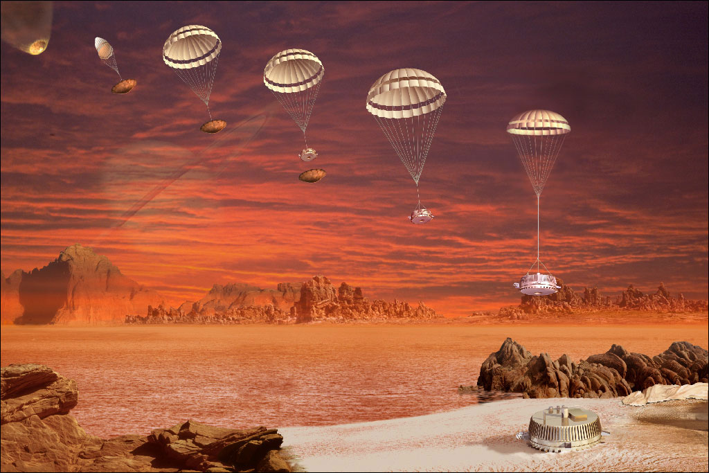
Huygens descent and landing overview. Image credit: ESA Click to enlarge
The Surface Science Package (SSP) revealed that Huygens could have hit and cracked an ice ?pebble? on landing, and then it slumped into a sandy surface possibly dampened by liquid methane. Had the tide on Titan just gone out?

The SSP comprised nine independent sensors, chosen to cover the wide range of properties that be encountered, from liquids or very soft material to solid, hard ice. Some were designed primarily for landing on a solid surface and others for a liquid landing, with eight also operating during the descent.

Extreme and unexpected motion of Huygens at high altitudes was recorded by the SSP?s two-axis tilt sensor tilt sensor, suggesting strong turbulence whose meteorological origin remains unknown.

Penetrometry and accelerometry measurements on impact revealed that the surface was neither hard (like solid ice) nor very compressible (like a blanket of fluffy aerosol). Huygens landed on a relatively soft surface resembling wet clay, lightly packed snow and either wet or dry sand.

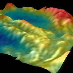
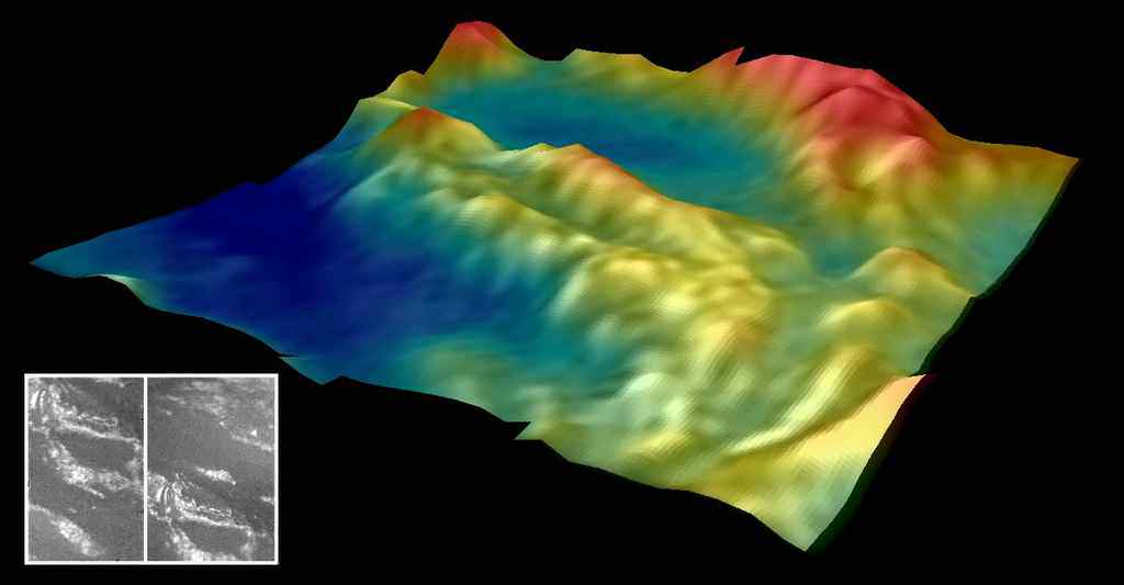
The probe had penetrated about 10 cm into surface, and settling gradually by a few millimetres after landing and tilting by a fraction of a degree. An initial high penetration force is best explained by the probe striking one of the many pebbles seen in the DISR images after landing.

Acoustic sounding with SSP over the last 90 m above the surface revealed a relatively smooth, but not completely flat, surface surrounding the landing site. The probe?s vertical velocity just before landing was determined with high precision as 4.6 m/s and the touchdown location had an undulating topography of around 1 metre over an area of 1000 sq. metres.

Those sensors intended to measure liquid properties (refractometer, permittivity and density sensors) would have performed correctly had the probe landed in liquid. The results from these sensors are still being analysed for indications of trace liquids, since the Huygens GCMS detected evaporating methane after touchdown.

Together with optical, radar and infrared spectrometer images from Cassini and images from the DISR instrument on Huygens, these results indicate a variety of possible processes modifying Titan?s surface.

Fluvial and marine processes appear most prominent at the Huygens landing site, although aeolian (wind-borne) activity cannot be ruled out. The SSP and HASI impact data are consistent with two plausible interpretations for the soft material: solid, granular material having a very small or zero cohesion, or a surface containing liquid.

In the latter case, the surface might be analogous to a wet sand or a textured tar/wet clay. The ?sand? could be made of ice grains from impact or fluvial erosion, wetted by liquid methane. Alternatively it might be a collection of photochemical products and fine-grained ice, making a somewhat sticky ?tar?.

The uncertainties reflect the exotic nature of the materials comprising the solid surface and possible liquids in this extremely cold (?180 ?C) environment.

Original Source: ESA Portal

Titan’s Atmosphere Surprised Scientists

Huygens probe descending through Titan’s atmosphere. Image credit: ESA Click to enlarge
Strong turbulence in the upper atmosphere, a second ionospheric layer and possible lightning were among the surprises found by the Huygens Atmospheric Structure Instrument (HASI) during the descent to Titan?s surface.

HASI provided measurements from an altitude of 1400 km down to the surface of the physical characteristics of the atmosphere and surface, such as temperature and density profiles, electrical conductivity, and surface structure. The Huygens SSP made measurements just above and on the surface of Titan.

High-altitude atmospheric structure had been inferred from earlier solar occultation measurements by Voyager, but the middle atmosphere (200?600 km) was not well determined, although telescopic observations indicated a complex vertical structure.

Very little was known about the surface of Titan because it is hidden by a thick ‘haze’ – initial speculation was that the surface was covered by a deep hydrocarbon ocean, but infrared and radar measurements showed definite albedo contrasts ?possibly consistent with lakes, but not with a global ocean.

Earlier observations showed that the surface pressure on Titan was comparable to that on Earth, and that methane formed a plausible counterpart to terrestrial water for cloud and rain formation. There was also speculation on the possibility of lightning occurring in Titan?s atmosphere that could affect the chemical composition of the atmosphere.

HASI found that in the upper part of the atmosphere, the temperature and density were both higher than expected. The temperature structure shows strong wave-like variations of 10-20 K about a mean of about 170 K. This, together with other evidence, indicates that Titan?s atmosphere has many different layers.

Models of Titan’s ionosphere predicted that galactic cosmic rays would produce an ionospheric layer with a maximum concentration of electrons between 70 and 90 km altitude. HASI also surprised the Huygens team by finding a second lower ionospheric layer, between 140 km and 40 km, with electrical conductivity peaking near 60 km.

HASI may also have seen the signature of lightning. Several electrical field impulse events were observed during the descent, caused by possible lightning activity in the spherical waveguide formed by the surface of Titan and the inner boundary of its ionosphere.

The vertical resolution of the temperature measurement was sufficient to resolve the structure of the planetary boundary layer. This boundary layer had a thickness of about 300 m at the place and time of landing. The surface temperature was accurately measured at 93.65?0.25 K and the pressure 1467?1 hPa (very close to measurements made earlier by Voyager, about 95K and 1400 hPa).

Original Source:ESA Portal

Ice Volcanoes on Enceladus

Saturn’s moon Enceladus backlit by the Sun. Image credit: NASA/JPL/SSI Click to enlarge
Recent Cassini images of Saturn’s moon Enceladus backlit by the sun show the fountain-like sources of the fine spray of material that towers over the south polar region. This image was taken looking more or less broadside at the “tiger stripe” fractures observed in earlier Enceladus images. It shows discrete plumes of a variety of apparent sizes above the limb of the moon.

The Cassini-Huygens mission is a cooperative project of NASA, the European Space Agency and the Italian Space Agency. The Jet Propulsion Laboratory, a division of the California Institute of Technology in Pasadena, manages the mission for NASA’s Science Mission Directorate, Washington, D.C. The Cassini orbiter and its two onboard cameras were designed, developed and assembled at JPL. The imaging operations center is based at the Space Science Institute in Boulder, Colo.

For more information about the Cassini-Huygens mission visit http://saturn.jpl.nasa.gov . The Cassini imaging team homepage is at http://ciclops.org .

Original Source: NASA/JPL/SSI News Release

Death Star Mimas and Its Giant Crater Herschel

Mimas standing in front of Saturn’s rings. Image credit: NASA/JPL/SSI Click to enlarge
Impact-battered Mimas steps in front of Saturn’s rings, showing off its giant 130-kilometer (80-mile) wide crater Herschel.

The illuminated terrain seen here is on the moon’s leading hemisphere. North on Mimas is up and rotated 20 degrees to the left. Mimas is 397 kilometers (247 miles) across.

The image was taken in visible green light with the Cassini narrow-angle camera on Oct. 13, 2005 at a distance of approximately 711,000 kilometers (442,000 miles) from Mimas and at a Sun-Mimas-spacecraft, or phase, angle of 112 degrees. The image scale is 4 kilometers (3 miles) per pixel.

The Cassini-Huygens mission is a cooperative project of NASA, the European Space Agency and the Italian Space Agency. The Jet Propulsion Laboratory, a division of the California Institute of Technology in Pasadena, manages the mission for NASA’s Science Mission Directorate, Washington, D.C. The Cassini orbiter and its two onboard cameras were designed, developed and assembled at JPL. The imaging operations center is based at the Space Science Institute in Boulder, Colo.

For more information about the Cassini-Huygens mission visit http://saturn.jpl.nasa.gov . The Cassini imaging team homepage is at http://ciclops.org .

Original source: NASA/JPL/SSI News Release

Carthage Linea on Dione

Dione’s icy surface. Image credit: NASA/JPL/SSI Click to enlarge
Dione’s icy surface is scarred by craters and sliced up by multiple generations of geologically-young bright fractures. Numerous fine, roughly-parallel linear grooves run across the terrain in the upper left corner.

Most of the craters seen here have bright walls and dark deposits of material on their floors. As on other Saturnian moons, rockslides on Dione (1,126 kilometers, or 700 miles across) may reveal cleaner ice, while the darker materials accumulate in areas of lower topography and lower slope (e.g. crater floors and the bases of scarps).

The terrain seen here is centered at 15.4 degrees north latitude, 330.3 degrees west longitude, in a region called Carthage Linea. North on Dione is up and rotated 50 degrees to the left.

The image was taken in visible green light with the Cassini narrow-angle camera on Oct. 11, 2005, at a distance of approximately 19,600 kilometers (12,200 miles) from Dione. The image scale is about 230 meters (760 feet) per pixel.

The Cassini-Huygens mission is a cooperative project of NASA, the European Space Agency and the Italian Space Agency. The Jet Propulsion Laboratory, a division of the California Institute of Technology in Pasadena, manages the mission for NASA’s Science Mission Directorate, Washington, D.C. The Cassini orbiter and its two onboard cameras were designed, developed and assembled at JPL. The imaging operations center is based at the Space Science Institute in Boulder, Colo.

For more information about the Cassini-Huygens mission visit http://saturn.jpl.nasa.gov . The Cassini imaging team homepage is at http://ciclops.org .

Original Source: NASA/JPL/SSI News Release

Good Look at Dione

Saturn’s Moon Dione. Image credit: NASA/JPL/SSI Click to enlarge
Cassini prepared for its rendezvous with Dione on Oct. 11, 2005, capturing the brilliant, cratered iceball in front of its shadow-draped planet.

The terrain seen here becomes notably darker toward the west, and is crosscut by the bright, fresh canyons that form wispy markings on Dione’s trailing hemisphere. Dione is 1,126 kilometers (700 miles) across.

The image was taken in visible light with the Cassini wide-angle camera at a distance of approximately 24,500 kilometers (15,200 miles) from Dione and at a Sun-Dione-spacecraft, or phase, angle of 22 degrees. The image scale is about 2 kilometers (1 mile) per pixel.

The Cassini-Huygens mission is a cooperative project of NASA, the European Space Agency and the Italian Space Agency. The Jet Propulsion Laboratory, a division of the California Institute of Technology in Pasadena, manages the mission for NASA’s Science Mission Directorate, Washington, D.C. The Cassini orbiter and its two onboard cameras were designed, developed and assembled at JPL. The imaging operations center is based at the Space Science Institute in Boulder, Colo.

For more information about the Cassini-Huygens mission visit http://saturn.jpl.nasa.gov. The Cassini imaging team homepage is at http://ciclops.org .

Original Source: NASA/JPL/SSI News Release

Wispy Terrain on Dione

Saturn’s moon Dione. Image credit: NASA/JPL/SSI Click to enlarge
The soft appearance of Dione’s wispy terrains belies their true nature. They are, in fact, complex systems of crisp, braided fractures that cover the moon’s trailing hemisphere.

(See Dione’s Surprise for a closer view of the fractures.)

This view shows the western potion of the wispy terrain on Dione (1,126 kilometers, or 700 miles across). The craters Dido and Antenor can be seen near the terminator at lower left. In the rings above, the dark Cassini Division between the A and B rings is visible.

The image was taken in visible light with the Cassini narrow-angle camera on Oct. 9, 2005, at a distance of approximately 1.8 million kilometers (1.1 million miles) from Dione and at a Sun-Dione-spacecraft, or phase, angle of 52 degrees. The image scale is 11 kilometers (7 miles) per pixel.

The Cassini-Huygens mission is a cooperative project of NASA, the European Space Agency and the Italian Space Agency. The Jet Propulsion Laboratory, a division of the California Institute of Technology in Pasadena, manages the mission for NASA’s Science Mission Directorate, Washington, D.C.

The Cassini orbiter and its two onboard cameras were designed, developed and assembled at JPL. The imaging operations center is based at the Space Science Institute in Boulder, Colo. For more information about the Cassini-Huygens mission visit http://saturn.jpl.nasa.gov . The Cassini imaging team homepage is at http://ciclops.org .

Original Source: NASA/JPL/SSI News Release

Close-Up on Pandora

Cassini’s best close-up view of Pandora. Image credit: NASA/JPL/SSI Click to enlarge
Cassini’s best close-up view of Saturn’s F ring shepherd moon, Pandora, shows that this small ring-moon is coated in fine dust-sized icy material.

Craters formed on this object by impacts appear to be covered by debris, a process that probably happens rapidly in a geologic sense. The grooves and small ridges on Pandora (84 kilometers, or 52 miles across) suggest that fractures affect the overlying smooth material.

The crisp craters on another Saturn moon, Hyperion, provide a contrasting example of craters on a small object (see Odd World).

Cassini acquired infrared, green and ultraviolet images on Sept. 5, 2005, which were combined to create this false-color view. The image was taken with the Cassini spacecraft narrow-angle camera at a distance of approximately 52,000 kilometers (32,000 miles) from Pandora and at a Sun-Pandora-spacecraft, or phase, angle of 54 degrees. Resolution in the original image was about 300 meters (1,000 feet) per pixel. The image has been magnified by a factor of two to aid visibility.

The Cassini-Huygens mission is a cooperative project of NASA, the European Space Agency and the Italian Space Agency. The Jet Propulsion Laboratory, a division of the California Institute of Technology in Pasadena, manages the mission for NASA’s Science Mission Directorate, Washington, D.C. The Cassini orbiter and its two onboard cameras were designed, developed and assembled at JPL. The imaging operations center is based at the Space Science Institute in Boulder, Colo.

For more information about the Cassini-Huygens mission visit http://saturn.jpl.nasa.gov . The Cassini imaging team homepage is at http://ciclops.org .

Original Source: NASA/JPL/SSI News Release