Middle Latitude Clouds on Titan Are Familiar

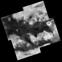
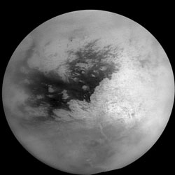
Saturn’s Moon Titan. Image credit: NASA/JPL/SSI. Click to enlarge.
University of Arizona scientists say that the peculiar clouds at middle latitudes in Titan’s southern hemisphere may form in the same way as distinct bands of clouds form at Earth’s equator.

“Titan’s weather is very different from Earth’s,” said UA associate professor Caitlin Griffith. “If you walked past Titan’s minus-40-degree-latitude line, you might be showered with liquid natural gas. If you decided to visit Titan’s south pole, you might encounter a storm the size of a hurricane which also consists of methane, more commonly known as natural gas,” Griffith said. “Otherwise, don’t expect clouds on Titan.”

Titan’s weather forecast has remained the same for years, and that baffles scientists. They don’t understand why clouds a thousand miles long stretch over the temperate latitude.

“Imagine how curious it would be if beyond Earth’s poles, clouds existed only at the latitude that crosses New Zealand, Argentina and Chile,” Griffith said. “Furthermore, Henry Roe (of the California Institute of Technology) and his colleagues find that most of these peculiar clouds bunch up at zero degrees and 90 degrees longitude, analogous to Earth longitudes southwest and southeast of the Cape of Good Hope,” she added.

The highly localized nature of the clouds suggests that they have something to do with Titan’s surface, Griffith said. Scientists think ice volcanoes must be venting methane — the gas that condenses as clouds — into Titan’s hazy, mostly nitrogen atmosphere. Otherwise, the moon’s atmospheric methane would have vanished billions of years ago because methane is destroyed by ultraviolet sunlight.

Griffith, Paulo Penteado and Robert Kursinski of UA’s Lunar and Planetary Lab studied the origin of the clouds by analyzing cloud height and thickness using images from Cassini’s visual and infrared mapping spectrometer (VIMS). This instrument is among a suite of instruments on the Cassini spacecraft orbiting Saturn. It measures light at 256 different wavelenghts. Griffith is a member of the UA-based VIMS team, headed by Robert Brown of UA’s Lunar and Planetary Lab. Griffith and her colleagues analyzed images that gave them a 3-D view of the cloud and a six-frame movie that shows how it evolved over three hours.

“The structure of the clouds turns out to be complicated,” Griffith said. “We detected not one region, but many regions of cloud formation. Each long cloud consists of a number of vigorous storms where clouds rise to 40 kilometers altitude (25 miles) in a couple of hours and dissipate in the next half hour. The rate of cloud ascent and dissipation suggests that we are witnessing the formation of convective clouds, likely similar to thunderstorms, that disappear through rainfall.

“Over the next several hours we see the clouds form long tails, indicating that strong westerly winds stretch out the clouds and carry the particles downwind a thousand kilometers (more than 600 miles). This detailed look into the structure of these clouds reveals that the clouds evolve from a number of small active cloud formation centers lined up like an uneven string of beads long 40 degrees south latitude. These localized storms cause a healthy rain, and very long clouds, once the wind has stretched them out.”

Griffith argues that it’s improbable that many ice volcanoes, all aligned at 40 degrees south latitude, are forming these clouds. In addition, the scientists estimate that the cloud activity at zero degrees longitude, if volcanic, does not appear to spew out enough methane to create the mid-latitude cloud band. Smaller clouds actually lie upwind of the main cloud at zero degrees longitude, they note. The team also conclude that the clouds aren’t obviously caused by Saturn’s tidal pull on Titan’s atmosphere. They also don’t find evidence that mountains and lakes might cause mountain clouds or marine clouds, Griffith said.

“We believe that it’s no coincidence that Titan’s south polar cap of smog extends from the pole to 40 degrees south latitude — exactly where the methane cloud band appears,” Griffith said. The researchers suggest that global circulation may cause the air to rise at this latitutude on Titan, much as clouds form in a band around the Earth’s equator and rain on the Caribbean islands. “Such rising air would cut off air from the south polar region from mixing with the rest of the moon’s atmosphere, causing smog to build up and form a cap over the pole,” Griffith added.

Theoretical modeling supports the UA team’s conclusion, Griffith said. Pascal Ranou and his group in Paris studied Titan’s circulation with an elaborate and complicated general circulation model. His model predicts that solar heating naturally creates rising air on Titan at 40 degrees south latitude.

The next mystery is why Titan’s southern mid-latitude clouds are bunched at zero degrees longitude. There’s no evidence yet that volcanoes, mountain ranges or Saturn’s tides are involved, Griffith said. “What’s causing the bunching is unclear, and likely involves unknown features on Titan’s still largely unexplored surface,” Griffith said.

Griffith, Kursinki and Penteado are publishing an article on their research in the Oct. 21 issue of Science.

The Cassini-Huygens mission is a cooperative project of NASA, the European Space Agency and the Italian Space Agency. The Jet Propulsion Laboratory, a division of the California Institute of Technology in Pasadena, Calif., manages the mission for NASA’s Science Mission Directorate, Washington, D.C. The Cassini orbiter and its two onboard cameras were designed, developed and assembled at JPL. The Visual and Infrared Mapping Spectrometer team is based at The University of Arizona in Tucson.

Original Source: University of Arizona News Release

Cassini’s Closeup View of Dione

Dione perched in front of Saturn. Image credit: NASA/JPL/SSI. Click to enlarge.
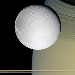
Sitting in the tranquility of space is the pale moon Dione, looking as if it’s posing for a painter. The moon is set against the stunning backdrop of Saturn, adorned in gold and draped with hues of blue.

Breathtaking views and a movie of the icy world are now available at http://saturn.jpl.nasa.gov and http://www.nasa.gov/cassini .

During the Cassini spacecraft’s only close flyby of the grayish moon, on Oct. 11, 2005, the spacecraft came within 500 kilometers (310 miles) of the surface.

Like most of its counterparts in the Saturnian system, Dione shows a heavily cratered surface. It has a signature style all its own that includes streaky terrains dominating one whole side of the moon. The fine latitudinal streaks appear to crosscut everything and appear to be the youngest feature type in this region of Dione. These striking cracks and fractures are caused by tectonic activity.

“Dione seems to be an older sibling of Enceladus,” said Dr. Bonnie Buratti, scientist on the Cassini visual and infrared mapping spectrometer team at NASA’s Jet Propulsion Laboratory, Pasadena, Calif. “We think that the cracked features of Dione may be the older version of the tiger stripes on Enceladus. Enceladus is the up-and-coming moon, complete with a recently active history, while Dione is the older, more mature moon.”

The Cassini infrared spectrometer team is working on compositional maps of the moon’s surface.

As it departed its encounter with Saturn?bfs moon Dione, Cassini sailed above an unreal landscape blasted by impacts. The rising Sun throws craters into sharp contrast and reveals steep crater walls.
Multiple generations of fractures are visible on Dione. Numerous fine, roughly parallel grooves run across the terrain and are interrupted by the larger, irregular, bright fractures. In several places, fractures postdate some deposits in the bottoms of craters.

The Cassini ultraviolet imaging spectrograph team reports the detection of water ice on the surface of Dione and also finds striking brightness variations across the surface. This could be the result of cracks and fractures in the ice. “The ice in the fractures appears to be different than in the surrounding terrain. This may be due to the grain size variations,” said Dr. Amanda Hendrix, Cassini scientist at JPL.

As on other Saturnian moons, rockslides on Dione may reveal cleaner ice, while the darker materials accumulate in areas of lower topography, such as crater floors and the bases of scarps.

Scientists on the Cassini fields and particles instruments note that early results do not support the presence of an atmosphere. Dione orbits Saturn within the broad, tenuous E-ring. Hence, scientists will be looking to see if Dione, like Enceladus, is a source of material in the E-ring. They also seek to learn whether the E-ring is affecting Dione’s surface. Over the coming months, scientists will begin to piece together a more detailed story of Dione.

Following the rendezvous with Dione, Cassini captured its best views ever of the tiny moon Telesto. “Telesto was too small in Voyager images to see detail on the surface. Cassini has given us the best views of the potato-shaped chunk of ice,” said Dr. Candice Hansen, Cassini scientist at JPL. Early results indicate the entire moon, roughly 24 kilometers across (15 miles), is ice.

Next up for Cassini, on Oct. 28, is a close pass of Titan, Saturn’s largest moon. During this pass Cassini’s powerful radar will be pointed to image the Huygens probe landing site and surrounding terrain.

Original Source: NASA/JPL/SSI News Release

Large Craters on Dione

Large craters across the surface of Dione. Image credit: NASA/JPL/SSI. Click to enlarge.
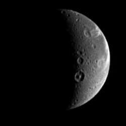
When naming features on other worlds, scientists like to follow themes, and Dione is no exception. Dione possesses numerous features with names from Virgil’s “Aeneid.” The prominent crater showing a central peak below the center is Dido, a 118-kilometer-wide (73-mile) crater named after the supposed founder of Carthage. The crater just above Dido is Antenor, an 82-kilometer-wide (51-mile) impact crater named after the nephew of Priam who founded the Italian city of Padua. At the upper right is the 97-kilometer-wide (60-mile) impact crater Turnus, which lies at the western end of Carthage Linea, a region of bright, fractured terrain. Dione is 1,118 kilometers (695 miles) across.

The sunlit terrain seen here shows some of the wispy markings on the moon’s trailing hemisphere. Cassini revealed that these markings are actually a complex system of fractures.

North on Dione is up and rotated 25 degrees to the left.

The image was taken in visible light with the Cassini spacecraft narrow-angle camera on Aug. 25, 2005, at a distance of approximately 1.1 million kilometers (700,000 miles) from Dione and at a Sun-Dione-spacecraft, or phase, angle of 107 degrees. Resolution in the original image was 7 kilometers (4 miles) per pixel. The image has been magnified by a factor of two and contrast-enhanced to aid visibility.

The Cassini-Huygens mission is a cooperative project of NASA, the European Space Agency and the Italian Space Agency. The Jet Propulsion Laboratory, a division of the California Institute of Technology in Pasadena, manages the mission for NASA’s Science Mission Directorate, Washington, D.C. The Cassini orbiter and its two onboard cameras were designed, developed and assembled at JPL. The imaging operations center is based at the Space Science Institute in Boulder, Colo.

For more information about the Cassini-Huygens mission visit http://saturn.jpl.nasa.gov . The Cassini imaging team homepage is at http://ciclops.org .

Original Source: NASA/JPL/SSI News Release

What’s that Bright Spot on Titan?

Bright spot on Titan. Image credit: NASA/JPL/University of Arizona/Space Science Institute Click to enlarge.
A 300-mile-wide patch that outshines everything else on Titan at long infrared wavelengths appears not to be a mountain, a cloud or a geologically active hot spot, University of Arizona scientists and Cassini team members say.

“We must be looking at a difference in surface composition,” said Jason W. Barnes, a postdoctoral researcher at UA’s Lunar and Planetary Lab. “That’s exciting because this is the first evidence that says not all of the bright areas on Titan are the same. Now we have to figure out what those differences are, what might have caused them.”

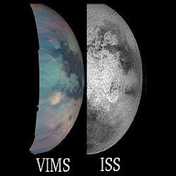
When NASA’s Cassini spacecraft flew by Titan on March 31 and again on April 16, its visual and infrared mapping spectrometer saw a feature that was spectacularly bright at 5-micron wavelengths just southeast of the continent-sized region called Xanadu.

The bright spot occurs where Cassini’s visible-wavelength imaging cameras photographed a bright arc-shaped feature approximately the same size in December 2004 and February 2005.

Cassini’s radar instrument, operating in the “passive” mode that is sensitive to microwaves emitted from a planetary surface, saw no temperature difference between the bright spot and surrounding region. That rules out the possibility that the 5-micron bright spot is a hot spot, such as a geologically active ice volcano, Barnes said.

Cassini microwave radiometry also failed to detect a temperature drop that would show up if some two-mile high mountain rose from Titan’s surface, he said.

And if the 5-micron bright spot is a cloud, it’s a cloud that hasn’t moved or changed shape for three years, according to ground-based observations made at the Keck Telescope and with Cassini’s visual and infrared mapping spectrometer during five different flybys. “If this is a cloud,” Barnes said, “it would have to be a persistent ground fog, like San Francisco on steroids, always foggy, all the time.”

“The bright spot must be a patch of surface with a composition different from anything we’ve seen yet. Titan’s surface is primarily composed of ice. It could be that something is contaminating the ice here, but what this might be is not clear,” Barnes said.

“There’s a lot left to explore about Titan. It’s a very complex, exciting place. It’s not obvious how it works. It’s going to be a lot of fun over the next couple of years figuring out how Titan works,” he said.

Barnes and 34 other scientists report the research in the Oct. 7 issue of Science. Authors include UA Lunar and Planetary Laboratory scientists and Cassini team members Robert H. Brown, head of Cassini’s visual and infrared mapping spectrometer team; Elizabeth P. Turtle and Alfred S. McEwen of the Cassini imaging team; Ralph D. Lorenz of the Cassini radar team; Caitlin Griffith of the Cassini visual and infrared mapping team; and Jason Perry and Stephanie Fussner, who work with McEwen and Turtle on Cassini imaging.

The Cassini-Huygens mission is a cooperative project of NASA, the European Space Agency and the Italian Space Agency. The Jet Propulsion Laboratory, a division of the California Institute of Technology in Pasadena, Calif., manages the mission for NASA’s Science Mission Directorate, Washington, D.C. The Cassini orbiter and its two onboard cameras were designed, developed and assembled at JPL. The imaging team is based at the Space Science Institute in Boulder, Colo. The Visual and Infrared Mapping Spectrometer team is based at The University of Arizona in Tucson .

Original Source: UA News Release

Vivid View of Spongy Hyperion

Saturn’s moon Hyperion. Image credit: NASA/JPL/SSI. Click to enlarge.
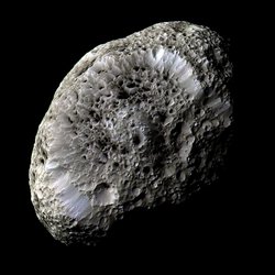
Cassini performed back-to-back flybys of Saturn moons Tethys and Hyperion last weekend, coming closer than ever before to each of them. Tethys has a scarred, ancient surface, while Hyperion is a strange, spongy-looking body with dark-floored craters that speckle its surface.

New images, mosaics and a movie of these bodies are available at http://saturn.jpl.nasa.gov , http://www.nasa.gov/cassini and http://ciclops.org .

Images of Tethys taken during Cassini’s close approach to the moon on Sept. 24, 2005, reveal an icy land of steep cliffs and craters. Cassini photographed the moon’s south pole, a region not seen by NASA’s Voyager spacecraft.

A giant rift called Ithaca Chasma cuts across the disk of Tethys. Much of the topography in this region, including that of Ithaca Chasma, has been thoroughly hammered by impacts. This appearance suggests that the event that created Ithaca Chasma happened very long ago.

Near a prominent peaked crater named Telemachus are the remnants of a very old crater named Teiresias. The ancient impact site is badly overprinted and eroded by impact weathering and degradation. All that remains is a circular pattern of hummocks that mark where the old crater rim existed. Many of the fresh-appearing craters exhibit unusually bright crater floors, in contrast to the dark-floored craters seen on Saturn’s oddly tumbling moon Hyperion.

Images of Hyperion taken on Sept. 26 show a surface dotted with craters and modified by some process, not yet understood, to create a strange, “spongy” appearance, unlike the surface of any other Saturn moon.

A false-color image of Hyperion reveals crisp details and variations in color across the strange surface that might represent differences in the composition of materials. Hyperion has a notably reddish tint when viewed in natural color.

Scientists are extremely curious to learn what the dark material is that fills many craters on this moon. Features within the dark terrain, including a 200-meter-wide (650-feet) impact crater surrounded by rays and numerous bright-rimmed craters, indicate that the dark material may be only tens of meters thick with brighter material beneath.

Scientists will also be examining Cassini’s sharp views in hopes of determining whether there have been multiple episodes of landslides on Hyperion. Such “downslope” movement is evident in the filling of craters with debris and the near elimination of many craters along the steeper slopes. Answers to these questions may help solve the mystery of why this object has evolved different surface forms from other moons of Saturn.

Cassini flew by Hyperion at a distance of only 500 kilometers (310 miles). Hyperion is 266 kilometers (165 miles) across, has an irregular shape, and spins in a chaotic rotation. Much of its interior is empty space, explaining why scientists call Hyperion a rubble-pile moon. This flyby was Cassini’s only close encounter with Hyperion in the prime mission four-year tour. Over the next few months, scientists will study the data in more detail.

Cassini flew by Tethys at a distance of approximately 1,500 kilometers (930 miles) above the surface. Tethys is 1,071 kilometers (665 miles) across and will be visited again by Cassini in the summer of 2007.

The Cassini-Huygens mission is a cooperative project of NASA, the European Space Agency and the Italian Space Agency. The Jet Propulsion Laboratory, a division of the California Institute of Technology in Pasadena, manages the Cassini-Huygens mission for NASA’s Science Mission Directorate, Washington, D.C. The Cassini orbiter and its two onboard cameras were designed, developed and assembled at JPL. The imaging team is based at the Space Science Institute, Boulder, Colo.

Original Source: NASA/JPL/SSI News Release

Sweeping View of the Rings

Sweeping view of Saturn’s rings. Image credit: NASA/JPL/SSI. Click to enlarge.
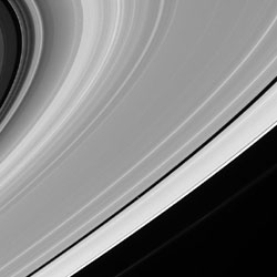
A grandiose gesture of gravity, Saturn’s icy rings fan out across many thousands of kilometers of space. The moon Pan (26 kilometers, or 16 miles across) dutifully follows its path, like the billions and billions of particles comprising the rings. The little moon is seen at the center of this view, within the Encke gap.

The famous Cassini Division spans upper left corner of the scene. The Cassini Division is approximately 4,800-kilometers-wide (2,980 miles) and is visible in small telescopes from Earth.

The narrow, knotted F ring is thinly visible just beyond the main rings.

The image was taken in visible light with the Cassini spacecraft narrow-angle camera on July 20, 2005, at a distance of approximately 2.1 million kilometers (1.3 million miles) from Saturn. The image scale on Pan is 13 kilometers (8 miles) per pixel.

The Cassini-Huygens mission is a cooperative project of NASA, the European Space Agency and the Italian Space Agency. The Jet Propulsion Laboratory, a division of the California Institute of Technology in Pasadena, manages the mission for NASA’s Science Mission Directorate, Washington, D.C. The Cassini orbiter and its two onboard cameras were designed, developed and assembled at JPL. The imaging operations center is based at the Space Science Institute in Boulder, Colo.

For more information about the Cassini-Huygens mission visit http://saturn.jpl.nasa.gov . The Cassini imaging team homepage is at http://ciclops.org .

Original Source: NASA/JPL/SSI News Release

Ghostly Spokes in the Rings

An image showing faint, narrow spokes in the outer B ring. Image credit: NASA/JPL/SSI Click to enlarge
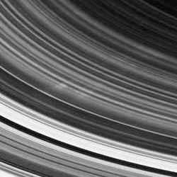
Scientists are celebrating the first Cassini spacecraft sighting of spokes, the ghostly radial markings discovered in Saturn’s rings by NASA’s Voyager spacecraft 25 years ago.

A sequence of images taken on the side of the rings not illuminated by the sun has captured a few faint, narrow spokes in the outer B ring, about 3,500 kilometers long and about 100 kilometers wide (2,200 miles by 60 miles).

The images can be seen at: http://www.nasa.gov/cassini, http://saturn.jpl.nasa.gov and http://ciclops.org .

Previously, scientists believed the visibility of spokes depended on the elevation of the sun above the rings. The less sunlight, the more visible the spokes. For this reason, they weren’t expecting to see spokes until later in the mission when the sun angle will be low.

In Voyager images from 25 years ago, the spokes appeared dark when seen at low sun angles and bright when seen at high sun angles. This behavior indicated that they were comprised of extremely small icy particles. Since Voyager days, spokes had been seen in images taken by NASA’s Hubble Space Telescope. The new Cassini images were taken at very high sun angles, where small particles can brighten substantially, making them more visible.

Determining the timing in the appearance of spokes will be of intense interest and will require monitoring spoke activity from a variety of geometries over several years. “Cassini has found that the Saturn Kilometric Radiation period has changed since Voyager, which though hard to believe, may mean that the rotation of Saturn’s interior has changed,” said Dr. Carolyn Porco, Cassini imaging team leader at the Space Science Institute in Boulder, Colo., and one of the first individuals to study spokes in Voyager images. “That would be a finding of enormous consequence, so we’ll be looking very closely to see if the frequency of spoke activity has changed too.”

Porco’s analysis of spokes in the early 1980s found that these narrow arrangements of small particles came and went with a period equal to that of the powerful bursts of radio waves, called Saturn Kilometric Radiation, discovered by Voyager and coming from Saturn’s magnetic field. This association indicated that spokes were a phenomenon involving electromagnetic effects due to Saturn’s magnetic field.

There is no commonly accepted theory for the creation of spokes. Some ideas suggest that spokes result from meteoroid impacts onto the rings; others suggest that they are created by instability in Saturn’s magnetic field, which surrounds the planet, near the rings. Whatever the cause, imaging team members will study the new spoke images and maintain their vigil for additional spoke sightings.

Cassini also completed a flyby of Saturn’s moon Titan on Wednesday, Sept. 7. During that flyby, one of two solid-state recorders on board the spacecraft failed to record science data as planned. The spacecraft team is troubleshooting the cause of the anomaly, and early indications point to a software problem that would be correctable with no long-term impacts. About half of the planned science data was received.

This was Cassini’s eighth flyby out of 45 Titan flybys planned in the nominal four-year tour.

The Cassini-Huygens mission is a cooperative project of NASA, the European Space Agency and the Italian Space Agency. The Jet Propulsion Laboratory, a division of the California Institute of Technology in Pasadena, manages the Cassini-Huygens mission for NASA’s Science Mission Directorate, Washington. The Cassini orbiter and its two onboard cameras were designed, developed and assembled at JPL. The imaging operations center is based at the Space Science Institute in Boulder, Colo.

Original Source: NASA/JPL/SSI News Release

Shoreline Found on Titan

The boundary of the bright (rough) region and the dark (smooth) region appears to be a shoreline. Image credit: NASA/JPL/SSI Click to enlarge
Images returned during Cassini’s recent flyby of Titan show captivating evidence of what appears to be a large shoreline cutting across the smoggy moon’s southern hemisphere. Hints that this area was once wet, or currently has liquid present, are evident.

“We’ve been looking for evidence of oceans or seas on Titan for some time. This radar data is among the most telling evidence so far for a shoreline,” said Steve Wall, radar deputy team leader from NASA’s Jet Propulsion Laboratory, Pasadena, Calif.

The new radar images can be seen at: http://www.nasa.gov/cassini and http://saturn.jpl.nasa.gov .

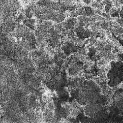
The images show what looks like a shoreline dividing a distinct bright and dark region roughly 1,700 kilometers long by 170 kilometers wide (1,060 by 106 miles). Directly to the right of a bright and possibly rough area is one that is very dark and smooth.

“This is the area where liquid or a wet surface has most likely been present, now or in the recent past, said Wall. “Titan probably has episodic periods of rainfall or massive seepages of liquid from the ground.”

The brightness patterns in the dark area indicate that it may once have been flooded with liquid that may now have partially receded. Bay-like features also lead scientists to speculate that the bright-dark boundary is most likely a shoreline.

“We also see a network of channels that run across the bright terrain, indicating that fluids, probably liquid hydrocarbons, have flowed across this region,” said Dr. Ellen Stofan, Cassini associate radar team member from Proxemy Research, Laytonsville, Md.

Taken together with the two other radar passes in October 2004 and February 2005, these very high resolution images have identified at least two distinct types of drainage and channel formation on Titan. Some channels in images from this pass are long and deep, with angular patterns and few tributaries, suggesting that fluids flow over great distances. By contrast, others show channels that form a denser network that might indicate rainfall.

Dr. Larry Soderblom with the U.S. Geological Survey in Flagstaff, Ariz., said, “It looks as though fluid flowed in these channels, cutting deeply into the icy crust of Titan. Some of the channels extend over 100 kilometers (60 miles). Some of them may have been fed by springs, while others are more complicated networks that were likely filled by rainfall.”

Titan has an environment somewhat similar to that of Earth before biological activity forever altered the composition of Earth’s atmosphere. The major difference on Titan, however, is the absence of liquid water, and Titan’s very low temperature. With a thick, nitrogen-rich atmosphere, Titan was until recently presumed to hold large seas or oceans of liquid methane. Cassini has been in orbit around Saturn for a year and has found no evidence for these large seas.

Cassini encountered an anomaly with one of two solid-state recorders during the Sept. 7 close flyby, resulting in some data not being recorded. Half of the data from the flyby was received, much to the delight of anxious scientists. The spacecraft team is troubleshooting the cause, and early indications point to a software problem that would be correctable with no long-term impacts.

This was Cassini’s eighth out of 45 Titan flybys planned in the nominal four-year tour. The next radar pass will be Oct. 26 when the team will focus on the Huygens probe landing site close to the equator.

The Cassini-Huygens mission is a cooperative project of NASA, the European Space Agency and the Italian Space Agency. JPL, a division of the California Institute of Technology in Pasadena, manages the Cassini-Huygens mission for NASA?s Science Mission Directorate, Washington. The Cassini orbiter was designed, developed and assembled at JPL. The radar instrument team is based at JPL, working with team members from the United States and several European countries.

Original Source: NASA/JPL/SSI News Release

Pan’s Corridor

Saturn’s moon Pan occupies the Encke Gap. Image credit: NASA/JPL/SSI Click to enlarge
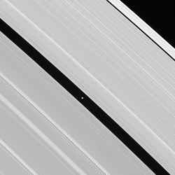
Saturn’s moon Pan occupies the Encke Gap at the center of this image, which also displays some of the A ring’s intricate wave structure. Pan is 26 kilometers (16 miles) across.

The two most prominent bright banded features seen on the left side of the image are spiral density waves, which propagate outward through Saturn’s rings. The bright crests represent areas with higher ring particle densities.

The image was taken in visible green light with the Cassini spacecraft narrow-angle camera on Aug. 1, 2005, at a distance of approximately 794,000 kilometers (493,000 miles) from Pan. The image scale is 5 kilometers (3 miles) per pixel.

The Cassini-Huygens mission is a cooperative project of NASA, the European Space Agency and the Italian Space Agency. The Jet Propulsion Laboratory, a division of the California Institute of Technology in Pasadena, manages the mission for NASA’s Science Mission Directorate, Washington, D.C. The Cassini orbiter and its two onboard cameras were designed, developed and assembled at JPL. The imaging operations center is based at the Space Science Institute in Boulder, Colo.

For more information about the Cassini-Huygens mission visit http://saturn.jpl.nasa.gov . The Cassini imaging team homepage is at http://ciclops.org .

Original Source: NASA/JPL/SSI News Release

Fensal-Aztlan Region on Titan

Fensal-Aztlan at Titan’s surface. Image credit: NASA/JPL/SSI Click to enlarge
During its Sept. 7, 2005, flyby of Titan, Cassini acquired images of territory on the moon’s Saturn-facing hemisphere that were assembled to create this mosaic.

Once known only as “the H” because the region looks something like the letter on its side, features in this region now possess provisional names. The northern branch of the H is now called “Fensal,” while the southern branch is known as “Aztlan.”

Fensal is littered with small “islands” ranging in size from 5 to 40 kilometers (3 to 25 miles) across. These landforms currently are thought to be water ice upland areas, surrounded by shallower terrain that is filled-in with dark particulate material from the atmosphere. A few larger islands are also seen, like Bazaruto Facula (near right, containing a dark crater), and several islands in western Fensal. When viewed in images of Shangri-La (on the other side of Titan), island-like landforms of this size tend to occur in clusters with apparent preferred orientations. The small islands in Fensal appear much more scattered (and most appear roughly circular), although a few islands do have an east-west orientation to their long axis.

Aztlan, on the other hand, appears comparatively devoid of small islands, with three large islands in its western reaches, plus only a few smaller islands. The largest of these islands is called “Sotra Facula” (just right of center in the bottom left mosaic frame), and measures 240 by 120 kilometers (149 to 75 miles) across.

The territory covered by this mosaic is similar to that seen in Titan Mosaic – East of Xanadu, which is composed of images from Cassini’s March 2005 Titan flyby. However, the gaps between the images in this mosaic are smaller and fewer than in the earlier mosaic.

The mosaic is centered on a region at 7 degrees north latitude, 21 degrees west longitude on Titan.

These Cassini spacecraft narrow-angle camera images were taken using a filter sensitive to wavelengths of infrared light centered at 938 nanometers. They were acquired at distances ranging from approximately 200,600 to 191,800 kilometers (124,600 to 119,200 miles) from Titan. Resolution in the images is about 2 kilometers (1.2 miles) per pixel. Each image has been strongly enhanced to improve the visibility of surface features.

The Cassini-Huygens mission is a cooperative project of NASA, the European Space Agency and the Italian Space Agency. The Jet Propulsion Laboratory, a division of the California Institute of Technology in Pasadena, manages the mission for NASA’s Science Mission Directorate, Washington, D.C. The Cassini orbiter and its two onboard cameras were designed, developed and assembled at JPL. The imaging operations center is based at the Space Science Institute in Boulder, Colo.

For more information about the Cassini-Huygens mission visit http://saturn.jpl.nasa.gov . The Cassini imaging team homepage is at http://ciclops.org .

Original Source: NASA/JPL/SSI News Release