Opportunity Rover Prospecting for Water Altered Minerals at Crater Rim in Marathon Valley

Panoramic view from NASA’s Opportunity rover looking down the floor of Marathon Valley and out to the vast expense of Endeavour Crater. Marathon Valley holds significant deposits of water altered clay minerals. This composite photo mosaic shows the rover’s robotic arm reaching out at left to investigate Martian rocks holding clues to the planets watery past, and robot shadow and wheel tracks visible at right. The mosaic combines a flattened fisheye hazcam image at left with a trio of navcam camera images taken on Sol 4144 (Sept. 20, 2015) and colorized. Credit: NASA/JPL/Cornell/Ken Kremer/kenkremer.com/Marco Di Lorenzo

As NASA’s Opportunity rover approaches the 12th anniversary of landing on Mars, her greatest science discoveries yet are likely within grasp in the coming months since she has successfully entered Marathon Valley from atop a Martian mountain and is now prospecting downhill for outcrops of water altered clay minerals.

The valley is the gateway to alien terrain holding significant caches of the water altered minerals that formed under environmental conditions conducive to support Martian microbial life forms, if they ever existed. But as anyone who’s ever climbed down a steep hill knows, you have to be extra careful not to slip and slide and break something, no matter how beautiful the view is – Because no one can hear you scream on Mars! See the downward looking valley view above.

After a years long Martian mountain climbing and mountain top exploratory trek, Opportunity entered a notch named Marathon Valley from atop a breathtakingly scenic ridge overlook atop the western rim of Endeavour Crater.

Marathon Valley measures about 300 yards or meters long and cuts downhill through the west rim of Endeavour crater from west to east. Endeavour crater spans some 22 kilometers (14 miles) in diameter.

See our photo mosaics illustrating Opportunity’s view around and about Marathon Valley and Endeavour Crater, created by the image processing team of Ken Kremer and Marco Di Lorenzo.

Our mosaic above affords a downward looking view from Marathon Valley on Sol 4144, Sept. 20. It uniquely combines raw images from the hazcam and navcam cameras to gain a wider perspective panoramic view of the steep walled valley, and also shows the rover at work stretching out the robotic arm to potential clay mineral rock targets at left. Opportunity’s shadow and wheel tracks are visible at right.

Mosaic view from Opportunity rover looking along the high walls and down the floor of Marathon Valley with deposits of water altered clay minerals and out to the vast expense of Endeavour Crater. This navcam camera photo mosaic was assembled from images taken on Sol 4159  (Oct. 5, 2015) and colorized.  Credit: NASA/JPL/Cornell/Marco Di Lorenzo/Ken Kremer/kenkremer.com
Mosaic view from Opportunity rover looking along the high walls and down the floor of Marathon Valley with deposits of water altered clay minerals and out to the vast expense of Endeavour Crater. This navcam camera photo mosaic was assembled from images taken on Sol 4159 (Oct. 5, 2015) and colorized. Credit: NASA/JPL/Cornell/Marco Di Lorenzo/Ken Kremer/kenkremer.com

In late July, Opportunity began the decent into the valley from the western edge and started investigating scientifically interesting rock targets by conducting a month’s long “walkabout” survey ahead of the upcoming frigid Martian winter – the seventh since touchdown at Meridiani Planum in January 2004.

The walkabout was done to identify targets of interest for follow up scrutiny in and near the valley floor. Opportunity’s big sister Curiosity conducted a similarly themed “walkabout” at the base of Mount Sharp near her landing site located on the opposite side of the Red Planet.

“The valley is somewhat like a chute directed into the crater floor, which is a long ways below. So it is somewhat scary, but also pretty interesting scenery,” writes Larry Crumpler, a science team member from the New Mexico Museum of Natural History & Science, in a mission update.

“Its named Marathon Valley because the rover traveled one marathon’s distance to reach it,” Prof. Ray Arvidson, the rover Deputy Principal Investigator of Washington University told Universe Today.

The NASA rover exceeded the distance of a marathon on the surface of Mars on March 24, 2015, Sol 3968. Opportunity has now driven over 26.46 miles (42.59 kilometers) over nearly a dozen Earth years.
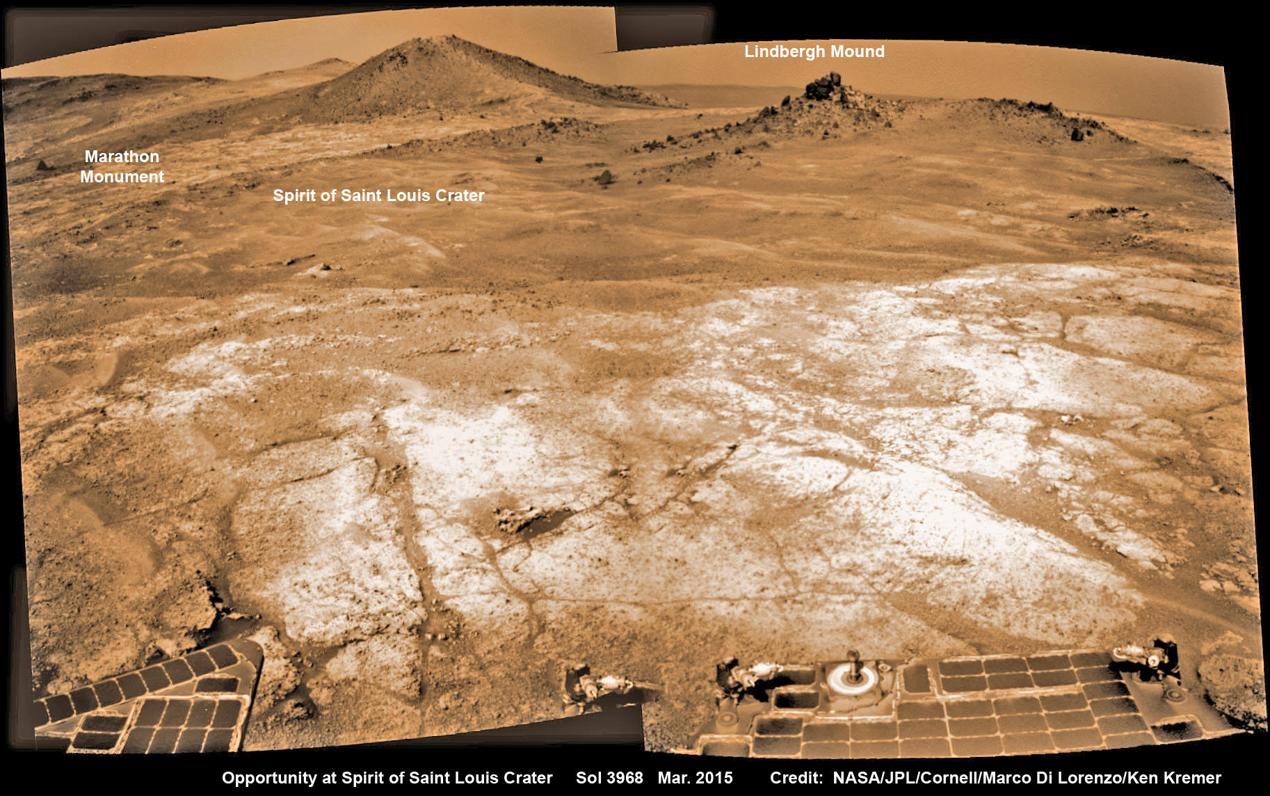
Opportunity’s view (annotated) on the day the NASA rover exceeded the distance of a marathon on the surface of Mars on March 24, 2015, Sol 3968 with features named in honor of Charles Lindbergh’s historic solo flight across the Atlantic Ocean in 1927. Rover stands at Spirit of Saint Louis Crater near mountaintop at Marathon Valley overlook and Martian cliffs at Endeavour crater holding deposits of water altered clay minerals.  This navcam camera photo mosaic was assembled from images taken on Sol 3968 (March 24, 2015) and colorized.  Credit: NASA/JPL/Cornell/Marco Di Lorenzo/Ken Kremer/kenkremer.com
Opportunity’s view (annotated) on the day the NASA rover exceeded the distance of a marathon on the surface of Mars on March 24, 2015, Sol 3968 with features named in honor of Charles Lindbergh’s historic solo flight across the Atlantic Ocean in 1927. Rover stands at Spirit of Saint Louis Crater near mountaintop at Marathon Valley overlook and Martian cliffs at Endeavour crater holding deposits of water altered clay minerals. This navcam camera photo mosaic was assembled from images taken on Sol 3968 (March 24, 2015) and colorized. Credit: NASA/JPL/Cornell/Marco Di Lorenzo/Ken Kremer/kenkremer.com

Now for the first time in history, a human emissary has arrived to conduct an up close inspection of and elucidate clues into this regions potential regarding Martian habitability.

The ancient, weathered slopes around Marathon Valley hold a motherlode of ‘phyllosilicate’ clay minerals, based on data obtained from the extensive Mars orbital measurements gathered by the CRISM spectrometer on NASA’s Mars Reconnaissance Orbiter (MRO) – accomplished earlier at the direction of Arvidson.

'Hinners Point' Above Floor of 'Marathon Valley' on Mars. This Martian scene shows contrasting textures and colors of "Hinners Point," at the northern edge of "Marathon Valley," and swirling reddish zones on the valley floor to the left. Credit: NASA/JPL-Caltech/Cornell Univ./Arizona State Univ.
‘Hinners Point’ Above Floor of ‘Marathon Valley’ on Mars. This Martian scene shows contrasting textures and colors of “Hinners Point,” at the northern edge of “Marathon Valley,” and swirling reddish zones on the valley floor to the left. Credit: NASA/JPL-Caltech/Cornell Univ./Arizona State Univ.

Initially the science team was focused on investigating the northern region of the valley while the sun was still higher in the sky and generating more power for research activities from the life giving solar arrays.

“We have detective work to do in Marathon Valley for many months ahead,” said Opportunity Deputy Principal Investigator Ray Arvidson, of Washington University in St. Louis.

But now that the rover is descending into a narrow valley with high walls, the rovers engineering handlers back on Earth have to exercise added caution regarding exactly where they send the Opportunity on her science forays during each sols drive, in order to maintain daily communications.

The high walls to the north and west of the valley ridgeline has already caused several communications blackouts for the “low-elevation Ultra-High-Frequency (UHF) relay passes to the west,” according to the JPL team controlling the rover.

Indeed on two occasions in mid September – coinciding with the days just before and after our Sol 4144 (Sept. 20) photo mosaic view above, “no data were received as the orbiter’s flight path was below the elevation on the valley ridgeline.

On Sept 17 and Sept. 21 “the high ridgeline of the valley obscured the low-elevation pass” and little to no data were received. However the rover did gather imagery and spectroscopic measurements for later transmission.

Now that winter is approaching the rover is moving to the southern side of Marathon Valley to soak up more of the sun’s rays from the sun-facing slope and continue research activities.

“During the Martian late fall and winter seasons Opportunity will conduct its measurements and traverses on the southern side of the valley,” says Arvidson.

“When spring arrives the rover will return to the valley floor for detailed measurements of outcrops that may host the clay minerals.”

The shortest-daylight period of this seventh Martian winter for Opportunity will come in January 2016.

NASA’s Opportunity Rover scans along a spectacular overlook toward Marathon Valley on March 3, 2015, showing flat-faced rocks exhibiting a completely new composition from others examined earlier. Marathon Valley and Martian cliffs on Endeavour crater hold deposits of water altered clay minerals. This navcam camera photo mosaic was assembled from images taken on Sol 3948 (March 3, 2015) and colorized. Credit: NASA/JPL/Cornell/Ken Kremer/kenkremer.com/Marco Di Lorenzo

As of today, Sol 4168, Oct, 15, 2015 Opportunity has taken over 206,300 images and traversed over 26.46 miles (42.59 kilometers).

Stay tuned here for Ken’s continuing Earth and planetary science and human spaceflight news.

Ken Kremer

Nearly 12 Year Traverse Map for NASA’s Opportunity rover from 2004 to 2015. This map shows the entire path the rover has driven during almost 12 years and more than a marathon runners distance on Mars for over 4163 Sols, or Martian days, since landing inside Eagle Crater on Jan 24, 2004 - to current location at the western rim of Endeavour Crater and descending into Marathon Valley. Rover surpassed Marathon distance on Sol 3968 and marked 11th Martian anniversary on Sol 3911. Opportunity discovered clay minerals at Esperance – indicative of a habitable zone - and is currently searching for more at Marathon Valley.  Credit: NASA/JPL/Cornell/ASU/Marco Di Lorenzo/Ken Kremer/kenkremer.com
Nearly 12 Year Traverse Map for NASA’s Opportunity rover from 2004 to 2015
This map shows the entire path the rover has driven during almost 12 years and more than a marathon runners distance on Mars for over 4163 Sols, or Martian days, since landing inside Eagle Crater on Jan 24, 2004 – to current location at the western rim of Endeavour Crater and descending into Marathon Valley. Rover surpassed Marathon distance on Sol 3968 and marked 11th Martian anniversary on Sol 3911. Opportunity discovered clay minerals at Esperance – indicative of a habitable zone – and is currently searching for more at Marathon Valley. Credit: NASA/JPL/Cornell/ASU/Marco Di Lorenzo/Ken Kremer/kenkremer.com

Shape-shifting neutrinos earn physicists the 2015 Nobel

Super-Kamiokande, a neutrino detector in Japan, holds 50,000 tons of ultrapure water surrounded by light tubes. Credit: Super-Kamiokande Observatory

What do Albert Einstein, Neils Bohr, Paul Dirac, and Marie Curie have in common? They each won the Nobel prize in physics. And today, Takaaki Kajita and Arthur McDonald have joined their ranks, thanks to a pioneering turn-of-the-century discovery: in defiance of long-held predictions, neutrinos shape-shift between multiple identities, and therefore must have mass.

The neutrino, a slight whiff of a particle that is cast off in certain types of radioactive decay, nuclear reactions, and high-energy cosmic events, could be called… shy. Electrically neutral but enormously abundant, half the time a neutrino could pass through a lightyear of lead without interacting with a single other particle. According to the Standard Model of particle physics, it has a whopping mass of zero.

As you can imagine, neutrinos are notoriously difficult to detect.

But in 1956, scientists did exactly that. And just a few years later, a trio of physicists determined that neutrinos came in not just one, not two, but three different types, or flavors: the electron neutrino, the muon neutrino, and the tau neutrino.

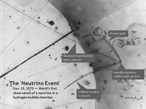
The first annotated neutrino event. Image credit:
The neutrino was first detected in 1956 by Clyde Cowan and Frederick Reines. In 1970, scientists captured the first image of a neutrino track in a hydrogen bubble chamber. Image: Argonne National Laboratory

But there was a problem. Sure, scientists had figured out how to detect neutrinos—but they weren’t detecting enough of them. In fact, the number of electron neutrinos arriving on Earth due to nuclear reactions in the Sun’s core was only one-third to one-half the number their calculations had predicted. What, scientists wondered, was happening to the rest?

Kajita, working at the Super-Kamiokande detector in Japan in 1998, and McDonald, working at the Sudbury Neutrino Observatory in Canada in 1999, determined that the electron neutrinos were not disappearing at all; rather, these particles were changing identity, spontaneously oscillating between the three flavor-types as they traveled through space.

Moreover, the researchers proclaimed, in order for neutrinos to make such transformations, they must have mass.

This is due to some quantum funny business having to do with the oscillations themselves. Grossly simplified, a massless particle, which always travels at the speed of light, does not experience time—Einstein’s theory of special relativity says so. But change takes time. Any particle that oscillates between identities needs to experience time in order for its state to evolve from one flavor to the the next.

The interior structure of the Sun. Credit: Wikipedia Commons/kelvinsong
Neutrinos are produced in abundance during fusion reactions at the center of our Sun, and oscillate between three different types, or flavors, on their way to Earth. Image: Wikipedia Commons/kelvinsong

Kajita and McDonald’s work showed that neutrinos must have a mass, albeit a very small one. But neutrinos are abundant in the Universe, and even a small mass has a large effect on all sorts of cosmic phenomena, from solar nuclear physics, where neutrinos are produced en masse, to the large-scale evolution of the cosmos, where neutrinos are ubiquitous.

The neutrino, no longer massless, is now considered to play a much larger role in these processes than scientists had originally believed.

What is more, the very existence of a massive neutrino undermines the theoretical basis of the Standard Model. In fact, Kajita’s and McDonald’s discovery provided some of the first evidence that the Standard Model might not be as airtight as had been previously believed, nudging scientists ever more in the direction of so-called “new physics.”

This is not the first time physicists have been awarded a Nobel prize for research into the nature of neutrinos. In 1988, Leon Lederman, Melvin Schwartz, and Jack Steinberger were awarded the prize for their discovery that neutrinos come in three flavors; in 1995, Frederick Reines won a Nobel for his detection of the neutrino along with Clyde Cowan; and in 2002, a Nobel was awarded to Raymond David Jr., the oldest person ever to receive a the prize in physics, and Masatoshi Koshiba for their detection of cosmic neutrinos.

Kajita, of the University of Tokyo, and McDonald, of Queen’s University in Canada, were awarded the prestigious prize this morning at a news conference in Stockholm.

Awesome Blue Skies and Red Surface Ice Found at Pluto – The Other Red Planet

Pluto’s Blue Sky: Pluto’s haze layer shows its blue color in this picture taken by the New Horizons Ralph/Multispectral Visible Imaging Camera (MVIC). The high-altitude haze is thought to be similar in nature to that seen at Saturn’s moon Titan. The source of both hazes likely involves sunlight-initiated chemical reactions of nitrogen and methane, leading to relatively small, soot-like particles (called tholins) that grow as they settle toward the surface. Credits: NASA/JHUAPL/SwRI

Much to the amazement and delight of scientists, the latest findings about Pluto reveal it possesses hazy blue skies and numerous red colored patches of water ice exposed on the surface of a world also now known as “The Other Red Planet.”

With each passing day, significant discoveries about Pluto continue piling up higher and higher as more and more data gathered and stored from this past summer’s historic flyby by NASA’s New Horizons reaches ground stations back here on Earth.

“Blue skies–Pluto is awesome!” says Alan Stern, New Horizons principal investigator from Southwest Research Institute (SwRI), Boulder, Colorado.

The bluish tint to Pluto’s skies were unexpectedly discovered after researchers examined the first color images of the high altitude atmospheric hazes returned by New Horizons last week that were taken by the probes Ralph/Multispectral Visible Imaging Camera (MVIC).

“Who would have expected a blue sky in the Kuiper Belt?” Stern said in a NASA statement.

During New Horizons flyby on July 14, 2015, it discovered that Pluto is the biggest object in the outer solar system and thus the ‘King of the Kuiper Belt.”

The Kuiper Belt comprises the third and outermost region of worlds in our solar system.

“It’s gorgeous!” exclaims Stern.

Moreover, the source of Pluto’s blue haze is different from Earth’s and more related to Titan, Saturn’s largest moon – currently being explored by NASA’s Cassini mission orbiting Saturn since 2004.

On Earth, the blue sky is caused by light scattering off tiny particles of nitrogen molecules. Whereas on Titan its related to soot-like particles called tholins.

Tholins are generated by a series of very complex sunlight-initiated chemical reactions between nitrogen and methane (CH4) high in the atmosphere. This eventually produces relatively small, soot-like particles of complex hydrocarbons.

“That striking blue tint tells us about the size and composition of the haze particles,” said New Horizons science team researcher Carly Howett, of SwRI, in a statement.

“A blue sky often results from scattering of sunlight by very small particles. On Earth, those particles are very tiny nitrogen molecules. On Pluto they appear to be larger — but still relatively small — soot-like particles we call tholins.”

As the tholins rain down on Pluto, they add to the widespread red surface coloring.

The Ralph instrument was also key in another discovery announced by New Horizons researchers.

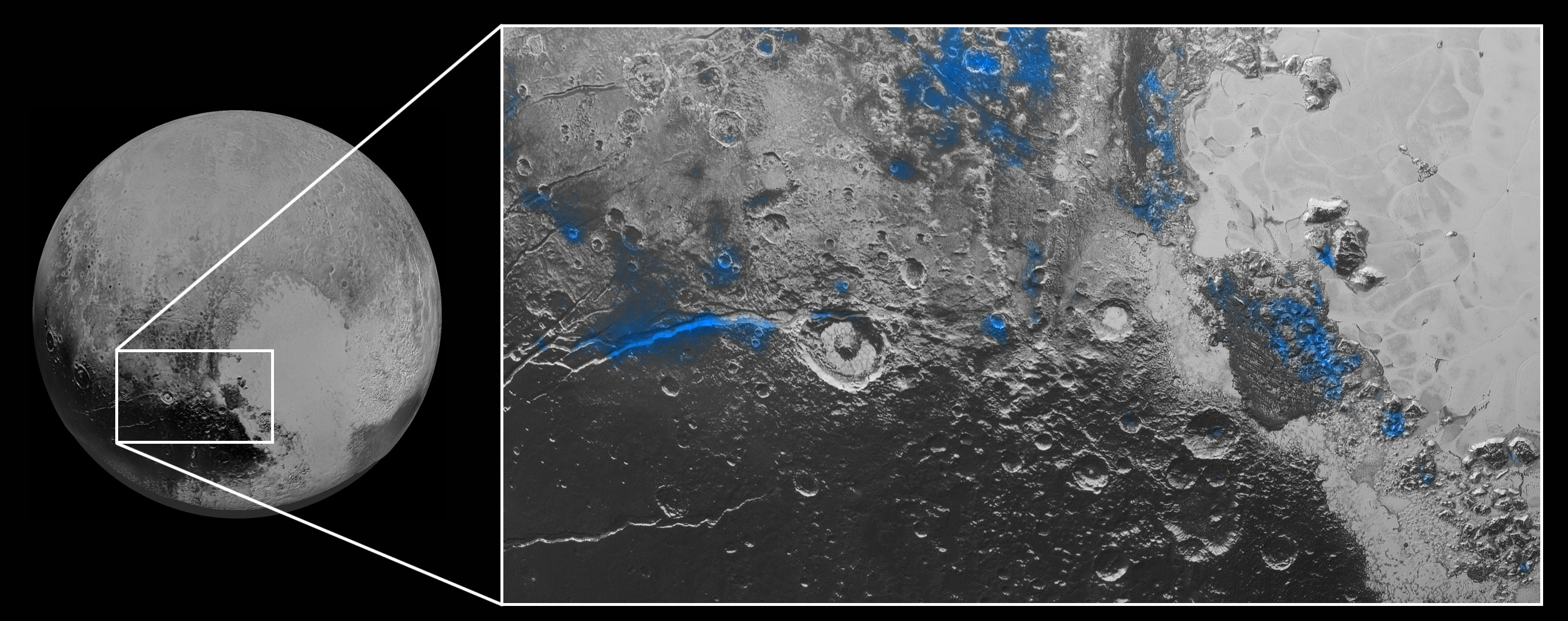
Numerous small, exposed regions of water ice on Pluto’s surface were discovered by combining measurements from the Ralph MVIC spectral composition mapper and infrared spectroscopy from the Linear Etalon Imaging Spectral Array (LEISA) instrument.

The strongest signatures of water ice were found in the Virgil Fossa and Viking Terra regions berby the western edge of Pluto’s huge heart-shaped Tombaugh Regio feature – see image below.

Water Ice on Pluto: Regions with exposed water ice are highlighted in blue in this composite image from New Horizons' Ralph instrument, combining visible imagery from the Multispectral Visible Imaging Camera (MVIC) with infrared spectroscopy from the Linear Etalon Imaging Spectral Array (LEISA). The strongest signatures of water ice occur along Virgil Fossa, just west of Elliot crater on the left side of the inset image, and also in Viking Terra near the top of the frame. A major outcrop also occurs in Baré Montes towards the right of the image, along with numerous much smaller outcrops, mostly associated with impact craters and valleys between mountains. The scene is approximately 280 miles (450 kilometers) across. Note that all surface feature names are informal.  Credits: NASA/JHUAPL/SwRI
Water Ice on Pluto: Regions with exposed water ice are highlighted in blue in this composite image from New Horizons’ Ralph instrument, combining visible imagery from the Multispectral Visible Imaging Camera (MVIC) with infrared spectroscopy from the Linear Etalon Imaging Spectral Array (LEISA). The strongest signatures of water ice occur along Virgil Fossa, just west of Elliot crater on the left side of the inset image, and also in Viking Terra near the top of the frame. A major outcrop also occurs in Baré Montes towards the right of the image, along with numerous much smaller outcrops, mostly associated with impact craters and valleys between mountains. The scene is approximately 280 miles (450 kilometers) across. Note that all surface feature names are informal. Credits: NASA/JHUAPL/SwRI

Water ice is only found in certain zones of Pluto for reasons yet to be understood. There may also be a relationship to the tholins, that likewise is yet to be gleaned.

“I’m surprised that this water ice is so red,” says Silvia Protopapa, a science team member from the University of Maryland, College Park. “We don’t yet understand the relationship between water ice and the reddish tholin colorants on Pluto’s surface.”

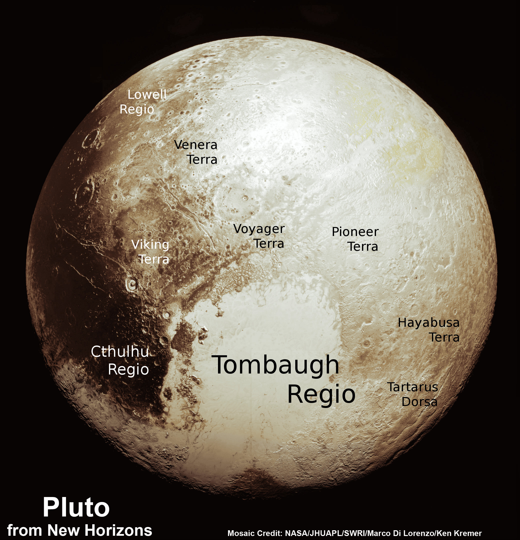
This new global mosaic view of Pluto was created from the latest high-resolution images to be downlinked from NASA’s New Horizons spacecraft and released on Sept. 11, 2015.   The images were taken as New Horizons flew past Pluto on July 14, 2015, from a distance of 50,000 miles (80,000 kilometers).  This new mosaic was stitched from over two dozen raw images captured by the LORRI imager and colorized.  Annotated with informal place names.  Credits: NASA/Johns Hopkins University Applied Physics Laboratory/Southwest Research Institute/Marco Di Lorenzo/Ken Kremer/kenkremer.com
This new global mosaic view of Pluto was created from the latest high-resolution images to be downlinked from NASA’s New Horizons spacecraft and released on Sept. 11, 2015. The images were taken as New Horizons flew past Pluto on July 14, 2015, from a distance of 50,000 miles (80,000 kilometers). This new mosaic was stitched from over two dozen raw images captured by the LORRI imager and colorized. Annotated with informal place names. Credits: NASA/Johns Hopkins University Applied Physics Laboratory/Southwest Research Institute/Marco Di Lorenzo/Ken Kremer/kenkremer.com
As of today, New Horizons remains healthy and is over 3.1 billion miles (5 billion kilometers) from Earth.

The team hopes to fire up the thrusters later this fall to propel the spacecraft toward a second Kuiper Belt Object (KBO) in 2019 tentativley named PT1, for Potential Target 1. It is much smaller than Pluto and was recently selected based on images taken by NASA’s Hubble Space Telescope.

Stay tuned here for Ken’s continuing Earth and planetary science and human spaceflight news.

Ken Kremer

NASA Webb Telescope Construction Leaps Forward with Delivery of Mirror Holding Backbone Flight Structure

View showing actual flight structure of mirror backplane unit for NASA's James Webb Space Telescope (JWST) that holds 18 segment primary mirror array and secondary mirror mount at front, in stowed-for-launch configuration. JWST is being assembled here by technicians inside the world’s largest cleanroom at NASA Goddard Space Flight Center, Greenbelt, Md. Credit: Ken Kremer/kenkremer.com

View showing actual flight structure of mirror backplane unit for NASA’s James Webb Space Telescope (JWST) that holds 18 segment primary mirror array and secondary mirror mount at front, in stowed-for-launch configuration. JWST is being assembled here by technicians inside the world’s largest cleanroom at NASA Goddard Space Flight Center, Greenbelt, Md. Credit: Ken Kremer/kenkremer.com
Story/imagery updated[/caption]

NASA GODDARD SPACE FLIGHT CENTER, MD – The construction pace for NASA’s James Webb Space Telescope (JWST) took a major leap forward with delivery of the actual flight structure that serves as the observatory’s critical mirror holding backbone – to NASA’s Goddard Space Flight Center in Greenbelt, Maryland and observed by Universe Today.

“We are in good shape with the James Webb Space Telescope,” said Dr. John Mather, NASA’s Nobel Prize Winning scientist, in an exclusive interview with Universe Today at NASA Goddard during a visit to the flight structure – shown in my photos herein. Note: Read an Italian language version of this story – here at Alive Universe

And the mammoth $8.6 Billion Webb telescope has mammoth scientific objectives as the scientific successor to NASA’s Hubble Space Telescope (HST) – now celebrating its 25th anniversary in Earth orbit.

“JWST has the capability to look back towards the very first objects that formed after the Big Bang,” Mather told Universe Today.

How is that possible?

“James Webb has a much bigger mirror than Hubble. So its resolution is much better,” said astronaut and NASA science chief John Grunsfeld, during an exclusive interview at NASA Goddard. Grunsfeld flew on a trio of Hubble servicing missions aboard the Space Shuttle, including the final one during STS-125 in 2009.

“JWST can look back further in time, and a greater distance than Hubble, so we can see those first stars and galaxies formed in the Universe.”

These discoveries are only possible with Webb, which will become the most powerful telescope ever sent to space when it launches in 2018.

Up close view of actual side wing backplane of NASA's James Webb Space Telescope (JWST) that will hold 3 of the observatory’s 18 primary mirrors, as technicians work inside cleanroom at NASA Goddard Space Flight Center, Greenbelt, Md.  Credit: Ken Kremer/kenkremer.com
Up close view of actual side wing backplane of NASA’s James Webb Space Telescope (JWST) that will hold 3 of the observatory’s 18 primary mirrors, as technicians work inside cleanroom at NASA Goddard Space Flight Center, Greenbelt, Md. Credit: Ken Kremer/kenkremer.com

The massive JWST flight structure unit includes the “backplane assembly” that clasps in place all of the telescopes primary and secondary mirrors, as well as its ISIM science module loaded with the observatory’s quartet of state-of-the-art research instruments.

“The backplane looks really great,” Grunsfeld told me.

Numerous NASA centers and aerospace companies are involved in building the observatory and its backplane structure holding the mirrors that will search back some 13.4 billion years.

“The backplane structure just arrived in late August from Northrop Grumman Aerospace Systems in Redondo Beach, California,” said Sandra Irish, JWST lead structural engineer during an interview with Universe Today at the NASA Goddard cleanroom facility.

“This is the actual flight hardware.”

Side view of flight unit mirror backplane assembly structure for NASA's James Webb Space Telescope (JWST) that holds primary mirror array and secondary mirror mount in stowed-for-launch configuration.  JWST is being assembled technicians inside the world’s largest cleanroom at NASA Goddard Space Flight Center, Greenbelt, Md.  Credit: Ken Kremer/kenkremer.com
Side view of flight unit mirror backplane assembly structure for NASA’s James Webb Space Telescope (JWST) that holds primary mirror array and secondary mirror mount in stowed-for-launch configuration. JWST is being assembled technicians inside the cleanroom at NASA Goddard Space Flight Center, Greenbelt, Md. Credit: Ken Kremer/kenkremer.com

The purpose of JWST’s backplane assembly is to hold the telescopes 18 segment, 21-foot (6.5-meter) diameter primary mirror nearly motionless while floating in the utterly frigid space environment, thereby enabling the observatory to peer out into deep space for precise science gathering measurements never before possible.

The massive telescope structure “includes the primary mirror backplane assembly; the main backplane support fixture; and the deployable tower structure that lifts the telescope off of the spacecraft. The three arms at the top come together into a ring where the secondary mirror will reside,” say officials.

The backplane traveled a long and winding road before arriving at Goddard.

“The backplane structure was designed and built at Orbital ATK with NASA oversight,” Irish explained. The assembly work was done at the firms facilities in Magna, Utah.

“Then it was sent to Northrop Grumman in Redondo Beach, California for static testing. Then it came here to Goddard. Orbital ATK also built the composite tubes for the ISIM science module structure.”

The observatory’s complete flight structure measures about 26 feet (nearly 8 meters) from its base to the tip of the tripod arms and mirror mount holding the round secondary mirror.

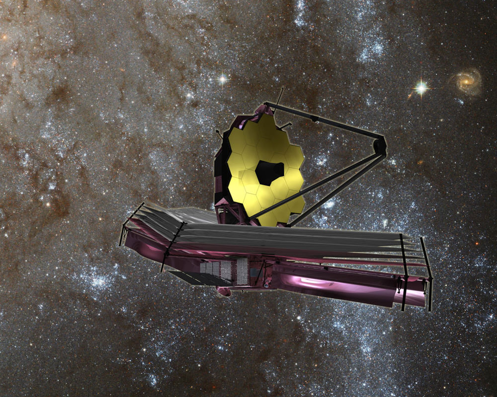
Artist’s concept of the James Webb Space Telescope (JWST) with Sunshield at bottom.  Credit: NASA/ESA
Artist’s concept of the James Webb Space Telescope (JWST) with Sunshield at bottom. Credit: NASA/ESA

The flight structure and backplane assembly arrived at Goddard in its stowed-for-launch configuration after being flown cross country from California.

“It is here for the installation of all the mirrors to build up the entire telescope assembly here at Goddard. It will be fully tested here before it is delivered to the Johnson Space Center in Houston and then back to California,” Irish elaborated.

The overall assembly is currently attached to a pair of large yellow and white fixtures that firmly secure the flight unit, to stand it upright and rotate as needed, as it undergoes acceptance testing by engineers and technicians before commencement of the next big step – the crucial mirror installation that starts soon inside the world’s largest cleanroom at NASA Goddard.

Overhead cranes are also used to maneuver the observatory structure as engineers inspect and test the unit.

But several weeks of preparatory work are in progress before the painstakingly precise mirror installation can begin under the most pristine cleanroom operating conditions.

“Right now the technicians are installing harnesses that we need to mount all over the structure,” Irish told me.

“These harnesses will go to our electronic systems and the mirrors in order to monitor their actuation on orbit. So that’s done first.”

What is the construction sequence at Goddard for the installation of the mirrors and science instruments and what comes next?

“This fall we will be installing every mirror, starting around late October/early November. Then next April 2016 we will install the ISIM science module inside the backplane structure.”

“The ISIM mounts all four of the telescope science instrument. So the mirrors go on first, then the ISIM gets installed and then it will really be the telescope structure.” ISIM carries some 7,500 pounds (2400 kg) of telescope optics and instruments.

“Then starting about next July/August 2016 we start the environmental testing.”

The actual flight mirror backplane is comprised of three segments – the main central segment and a pair of outer wing-like parts holding three mirrors each. They will be unfolded from the stowed-for-launch configuration to the “deployed” configuration to carry out the mirror installation. Then be folded back over into launch configuration for eventual placement inside the payload fairing of the Ariane V ECA booster rocket.

The telescope will launch from the Guiana Space Center in Kourou, French Guiana in 2018.

Gold coated flight spare of a JWST primary mirror segment made of beryllium and used for test operations inside the NASA Goddard clean room.  Credit: Ken Kremer- kenkremer.com
Gold coated flight spare of a JWST primary mirror segment made of beryllium and used for test operations inside the NASA Goddard clean room. Credit: Ken Kremer- kenkremer.com

The telescopes primary and secondary flight mirrors have already arrived at Goddard.

The mirrors must remained precisely aligned and nearly motionless in order for JWST to successfully carry out science investigations. While operating at extraordinarily cold temperatures between -406 and -343 degrees Fahrenheit the backplane must not move more than 38 nanometers, approximately 1/1,000 the diameter of a human hair.

To account for the tiniest of errors and enhance science, each of the primary mirrors is equipped with actuators for minute adjustments.

“A beautiful advantage of Webb that’s different from Hubble is the fact that we do have actuation [capability] of every single one of our mirrors. So if we are off by just a little bit on either our calculations or from misalignment from launch or the zero gravity release, we can do some fine adjustments on orbit.”

“We can adjust every mirror within 50 nanometers.”

“That’s important because we can’t send astronauts to fix our telescope. We just can’t.”

“The telescope is a million miles away.”

NASA’s team at Goddard has already practiced mirror installation because there are no second chances.

“We only have one shot to get this right!” Irish emphasized.

Watch for more on the mirror installation in my upcoming story.

JWST is the successor to the 25 year old Hubble Space Telescope and will become the most powerful telescope ever sent to space.

Webb is designed to look at the first light of the Universe and will be able to peer back in time to when the first stars and first galaxies were forming.

The Webb Telescope is a joint international collaborative project between NASA, the European Space Agency (ESA) and the Canadian Space Agency (CSA).

NASA has overall responsibility and Northrop Grumman is the prime contractor for JWST.

“The telescope is on schedule for its launch in 2018 in October,” Mather told me.

And the payoff from JWST will be monumental!

“On everything from nearby planets to the most distant universe, James Webb will transform our view of the Universe,” Grunsfeld beams.

Watch for more on JWST construction and mirror installation in part 2 soon.

Stay tuned here for Ken’s continuing Earth and Planetary science and human spaceflight news.

Ken Kremer

A comparison of the primary mirror used by Hubble and the primary mirror array used by the James Webb Space Telescope. Photo Credit: NASA
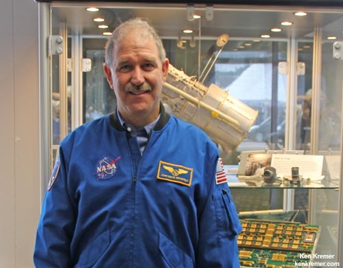
NASA Science chief and astronaut John Grunsfeld discusses James Webb Space Telescope project at NASA Goddard Space Flight Center in Maryland.  Credit: Ken Kremer/kenkremer.com
NASA Science chief and astronaut John Grunsfeld discusses James Webb Space Telescope project at NASA Goddard Space Flight Center in Maryland. Credit: Ken Kremer/kenkremer.com

New Nova Flares in Sagittarius – How to See it in Your Scope

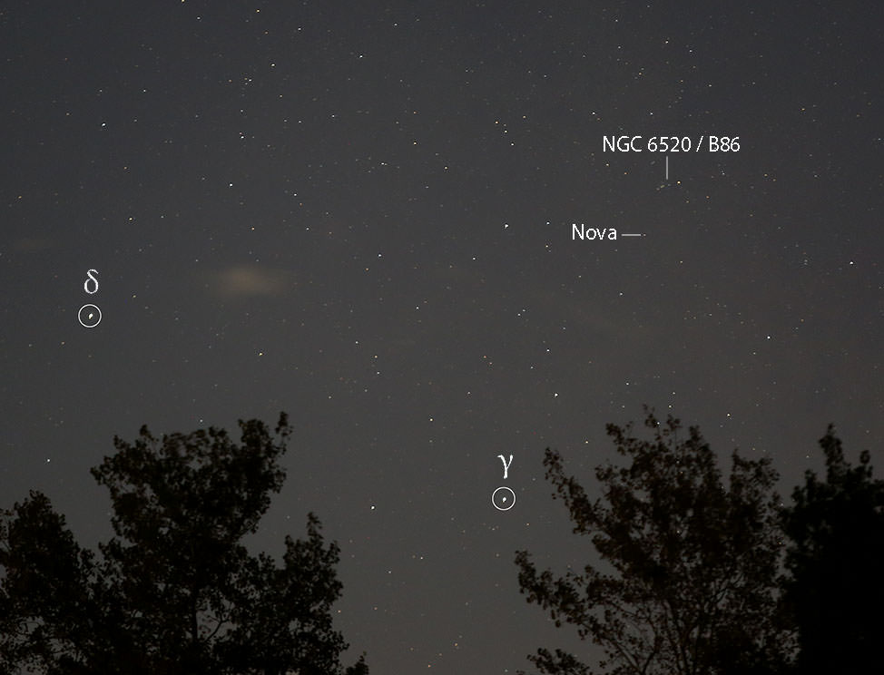
The new nova in Sagittarius is located just above the Spout in the Teapot and shines at about magnitude +9 this week - visible in a small telescope. Credit: Bob King

A nova farmer would do well in the fields of Sagittarius. Four nights ago on September 27, Japanese amateur Koichi Itagaki plucked another “new star” from its starry furrows, the third nova discovered there this year!

For a few days, it was informally called Nova Sagittarii #3, but today received the official title of V5669 Sagittarii. Like the others, this one’s bright enough to see in a small telescope.

Itagaki first recorded it in his patrol camera at magnitude +9.5. The universe conceals so many of its greatest conflagrations as points of light that go from faint to bright. Novae are no exception. Such is the amateur observer’s lot. We need bring a mental picture, knowledge and a bit of imagination to the table to appreciate this bits of light that go boom in the night.

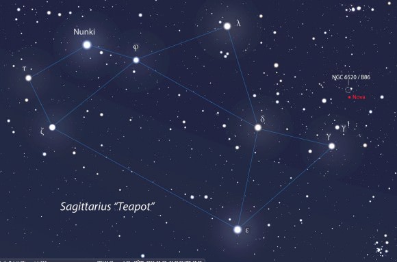
Use this wide finder map of Sagittarius to get a general idea of the nova's location. Lucky for us, it's in the same low power field of view of the pretty cluster-dark nebula combo NGC 6520 and Barnard 86, the so-called Inkspot Nebula. Source: Stellarium
Use this wide finder map of Sagittarius to get a general idea of the nova’s location. Lucky for us, it’s in the same low power field of view of the pretty cluster-dark nebula combo NGC 6520 and Barnard 86, the Inkspot Nebula. Source: Stellarium

Novae occur in binary star systems where a tiny but gravitationally-powerful white dwarf star pulls gases from a close companion star. The material piles up in a thin layer on the dwarf’s hot surface, fuses and burns explosively in a brilliant display of light. Suddenly, a star that may have been 15th or 20th magnitude flares brightly enough to see in a Walmart telescope.

Nova illustration with an expanding cloud of debris surrounding central fireball emitting red hydrogen-alpha light.

October’s not exactly prime time for viewing Sagittarius for mid-northern observers. By late evening twilight, it’s already in low in the southwestern sky. But if you can find an opening in that direction or if you’re lucky enough to have a 15-minute-wide gap between the trees like I do, you can spot this sucker. I set up my scope shortly before 8 o’clock or about an hour after sundown. Western Sagittarius remains in reasonably good view for about another hour.

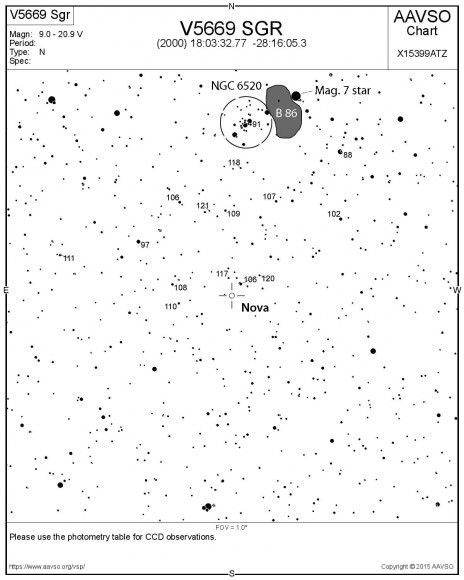
Start at the Gamma Sagittarii and star hop from there to Gamma 1 and then north to the small star cluster NGC 6520 and adjacent dark nebula Barnard 86. You may not see the nebula because of atmospheric extinction at low altitude, but the cluster stands out well. A magnitude 7 star lies along its northwestern edge, and the nova is just 1/2 degree from there. If you have a go-to scope, its celestial coordinates are: R.A. 18 hours 3.5 minutes, Dec. -28 degrees 16 minutes.

AAVSO chart showing the location of V5669 Sgr. North is up. I've added the star cluster NGC 6520 and Barnard 86. To make your own charts of the nova and its neighborhood, go to aavso.org, type in the star's name and select "Create a finder chart".
AAVSO chart showing the location of V5669 Sgr. North is up. I’ve added the star cluster NGC 6520 and Barnard 86. To create your own customized charts of the nova, go to aavso.org, type in the star’s name and select “Create a finder chart”. Credit: American Assn. of Variable Star Observers (AAVSO)

To precisely pinpoint the nova, use the AAVSO chart, which also includes comparison stars with their magnitudes labeled (but without the decimal point). Do you notice any color? Photos show it as pale red from the emission of hydrogen-alpha light in the deep red of the visual spectrum. Novae often emit H-alpha especially in their early, hot “fireball” stage as gases are rapidly expanding from the explosion into space.

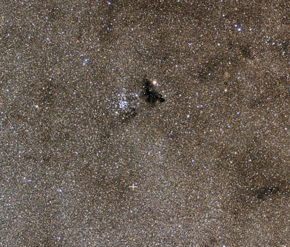
The pretty star cluster NGC 6520 and Ink Spot Nebula Barnard 86. The cross shows the location of the nova. Credit: Johannes Schedler / panther-observatory.com
The pretty star cluster NGC 6520 and Ink Spot Nebula Barnard 86. The cross shows the location of the nova. The star field may look intimidating, but this time exposure photo reveals minions more than are visible in an amateur telescope. Credit: Johannes Schedler / panther-observatory.com

No telling what the star will do in the coming days. That’s what makes novae and variable stars in general so much fun to watch. I caught the star Monday night September 28 at magnitude +8.6. The following night it dropped to 9.3 and then edged back up to 9.2 last night.  Astronomers study these fluctuations to understand a nova’s behavior and evolution. I can’t wait to see what it’s doing tonight.

One thing I really like about this nova is its location so near a pretty pair of deep sky objects. On your way to this amazing pinprick of light, stop by the cluster and dark nebula for a final farewell to the summer season.

Astonishing ‘Snakeskin’ Textured Mountains Discovered on Pluto

This color image of Pluto taken by NASA’s New Horizons spacecraft shows rounded and bizarrely textured mountains, informally named the Tartarus Dorsa, rise up along Pluto’s terminator and show intricate but puzzling patterns of blue-gray ridges and reddish material in between. This view, roughly 330 miles (530 kilometers) across, combines blue, red and infrared images taken by the Ralph/Multispectral Visual Imaging Camera (MVIC) on July 14, 2015, and resolves details and colors on scales as small as 0.8 miles (1.3 kilometers). Credits: NASA/JHUAPL/SWRI

The more we learn about Pluto, the weirder and weirder it gets.

The newest batch of high resolution Plutonian images has yielded “astonishing” discoveries of previously unseen ‘snakeskin’ textured mountains, that are simultaneously “dazzling and mystifying” scientists analyzing the latest data just returned from NASA’s New Horizons spacecraft.

New Horizons swooped past the Pluto planetary system during mankind’s history making first encounter on July 14, 2015 at a distance of 50,000 miles (80,000 kilometers).

The piano shaped probe gathered about 50 gigabits of data as it hurtled past Pluto, its largest moon Charon and four smaller moons.

Data from that priceless, once in a lifetime flyby is now trickling back to Earth.

The ‘snakeskin’ feature on Pluto’s utterly bizarre surface was unveiled to “astonished” scientists scrutinizing the latest data dump received over the past week, that included images taken by the Ralph instruments Multispectral Visual Imaging Camera (MVIC).

Features as small as 0.8 miles (1.3 kilometers) are resolved in detail.

The MVIC image stretches about 330 miles (530 kilometers) across the ‘snakeskin’ like landscape composed of rounded and bizarrely textured mountains that are informally named Tartarus Dorsa and that borders the bodies day-night terminator.

It shows intricate patterns of blue-gray ridges and reddish material in between that are puzzling researchers.

“It’s a unique and perplexing landscape stretching over hundreds of miles,” said William McKinnon, New Horizons Geology, Geophysics and Imaging (GGI) team deputy lead from Washington University in St. Louis.

“It looks more like tree bark or dragon scales than geology. This’ll really take time to figure out; maybe it’s some combination of internal tectonic forces and ice sublimation driven by Pluto’s faint sunlight.”

The Ralph/MVIC image is actually a composite of blue, red and infrared images.

The image of Tartarus Dorsa reveals a “multitude of previously unseen topographic and compositional details. It captures a vast rippling landscape of strange, aligned linear ridges that has astonished New Horizons team members,” say officials.

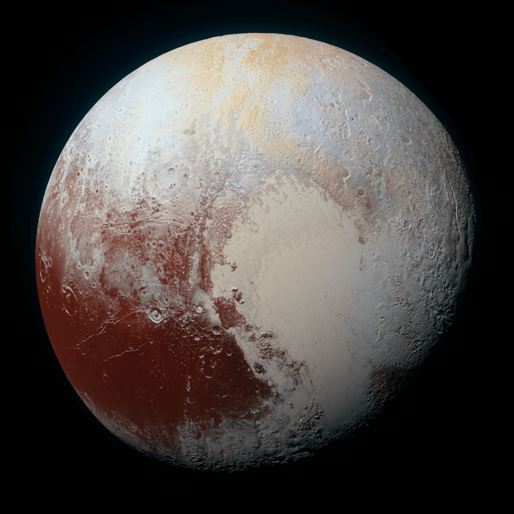
NASA’s New Horizons spacecraft captured this high-resolution enhanced color view of Pluto on July 14, 2015. The image combines blue, red and infrared images taken by the Ralph/Multispectral Visual Imaging Camera (MVIC). Pluto’s surface sports a remarkable range of subtle colors, enhanced in this view to a rainbow of pale blues, yellows, oranges, and deep reds. Many landforms have their own distinct colors, telling a complex geological and climatological story that scientists have only just begun to decode. The image resolves details and colors on scales as small as 0.8 miles (1.3 kilometers).  The viewer is encouraged to zoom in on the image on a larger screen to fully appreciate the complexity of Pluto’s surface features.   Credit: NASA/JHUAPL/SwRI
NASA’s New Horizons spacecraft captured this high-resolution enhanced color view of Pluto on July 14, 2015. The image combines blue, red and infrared images taken by the Ralph/Multispectral Visual Imaging Camera (MVIC). Pluto’s surface sports a remarkable range of subtle colors, enhanced in this view to a rainbow of pale blues, yellows, oranges, and deep reds. Many landforms have their own distinct colors, telling a complex geological and climatological story that scientists have only just begun to decode. The image resolves details and colors on scales as small as 0.8 miles (1.3 kilometers). The viewer is encouraged to zoom in on the image on a larger screen to fully appreciate the complexity of Pluto’s surface features. Credit: NASA/JHUAPL/SwRI

Another wider angle global view of Pluto downlinked on Sept. 19 shows a new “extended color” view of Pluto with an the extraordinarily rich color palette of the planet.

“We used MVIC’s infrared channel to extend our spectral view of Pluto,” said John Spencer, a GGI deputy lead from Southwest Research Institute (SwRI) in Boulder, Colorado.

“Pluto’s surface colors were enhanced in this view to reveal subtle details in a rainbow of pale blues, yellows, oranges, and deep reds. Many landforms have their own distinct colors, telling a wonderfully complex geological and climatological story that we have only just begun to decode.”

The image resolves details and colors on scales as small as 0.8 miles (1.3 kilometers).

High-resolution images of Pluto taken by NASA’s New Horizons spacecraft just before closest approach on July 14, 2015, reveal features as small as 270 yards (250 meters) across, from craters to faulted mountain blocks, to the textured surface of the vast basin informally called Sputnik Planum. Enhanced color has been added from the global color image. This image is about 330 miles (530 kilometers) across. For optimal viewing, zoom in on the image on a larger screen.  Credits: NASA/JHUAPL/SWRI
High-resolution images of Pluto taken by NASA’s New Horizons spacecraft just before closest approach on July 14, 2015, reveal features as small as 270 yards (250 meters) across, from craters to faulted mountain blocks, to the textured surface of the vast basin informally called Sputnik Planum. Enhanced color has been added from the global color image. This image is about 330 miles (530 kilometers) across. For optimal viewing, zoom in on the image on a larger screen. Credits: NASA/JHUAPL/SWRI

Beyond MVIC, additional new images taken by New Horizons’ narrow-angle Long Range Reconnaissance Imager (LORRI) during the July 14 were downlinked on Sept. 20.

They focus on the Sputnik Planum ice plains on the left side of the famous heart shaped Tombaugh Regio feature and are the highest resolution yet – as seen below. The team added color based on the global MVIC map shown above.

High-resolution images of Pluto taken by NASA’s New Horizons spacecraft just before closest approach on July 14, 2015, are the sharpest images to date of Pluto’s varied terrain—revealing details down to scales of 270 meters. In this 75-mile (120-kilometer) section of the taken from a larger, high-resolution mosaic, the textured surface of the plain surrounds two isolated ice mountains.  Credits: NASA/JHUAPL/SWRI
High-resolution images of Pluto taken by NASA’s New Horizons spacecraft just before closest approach on July 14, 2015, are the sharpest images to date of Pluto’s varied terrain—revealing details down to scales of 270 meters. In this 75-mile (120-kilometer) section of the taken from a larger, high-resolution mosaic, the textured surface of the plain surrounds two isolated ice mountains. Credits: NASA/JHUAPL/SWRI

Barely 5 or 6 percent of the 50 gigabits of data captured by New Horizons has been received by ground stations back on Earth.

“With these just-downlinked images and maps, we’ve turned a new page in the study of Pluto beginning to reveal the planet at high resolution in both color and composition,” added New Horizons Principal Investigator Alan Stern, of SwRI.

“I wish Pluto’s discoverer Clyde Tombaugh had lived to see this day.”

Stern says it will take about a year for all the data to get back. Thus bountiful new discoveries are on tap.

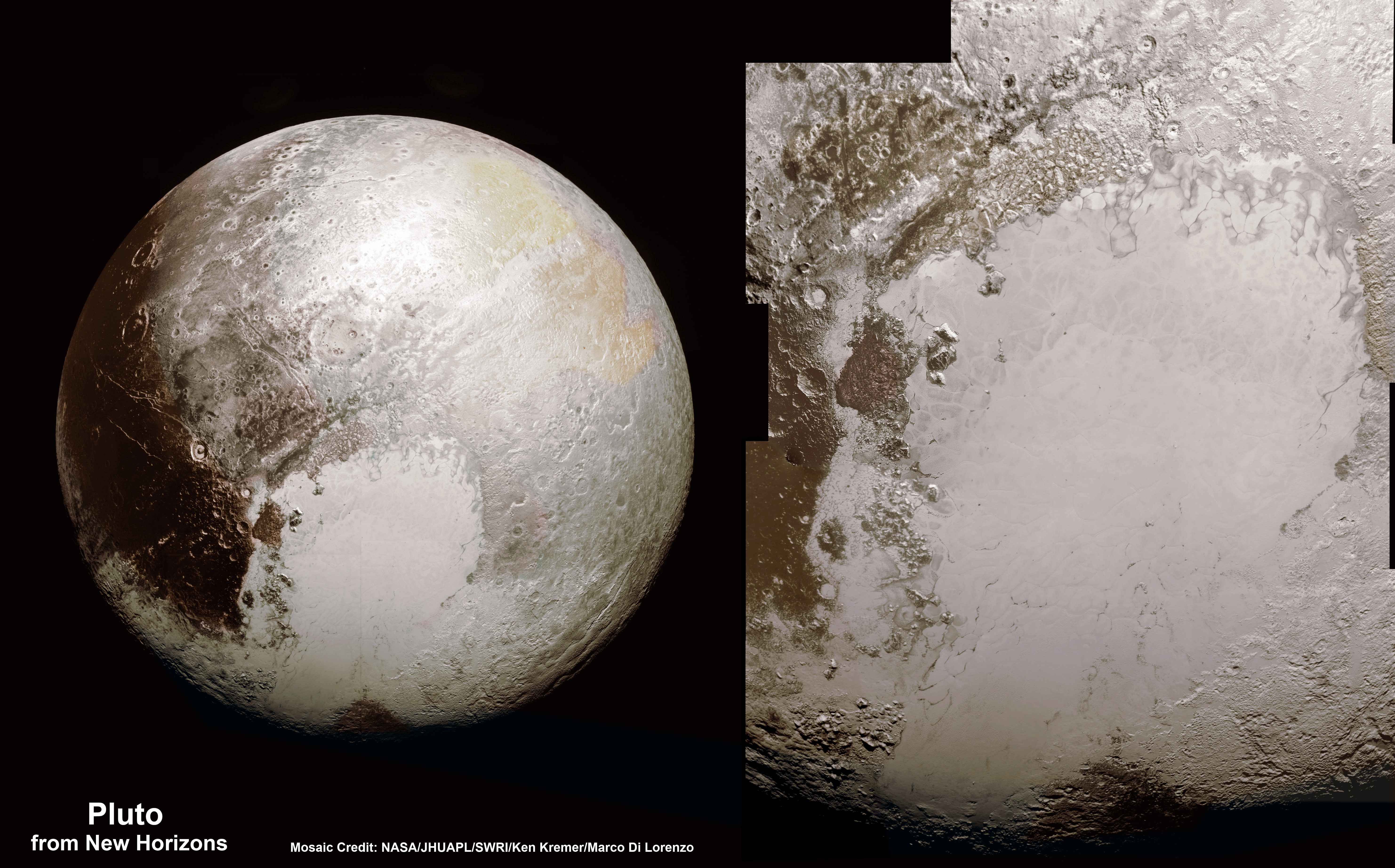
This new global mosaic view of Pluto was created from the latest high-resolution images to be downlinked from NASA’s New Horizons spacecraft and released on Sept. 11, 2015.   The images were taken as New Horizons flew past Pluto on July 14, 2015, from a distance of 50,000 miles (80,000 kilometers).  This mosaic was stitched from over two dozen raw images captured by the LORRI imager and colorized.  Right side mosaic comprises twelve highest resolution views of Tombaugh Regio heart shaped feature and shows objects as small as 0.5 miles (0.8 kilometers) in size.  Credits: NASA/Johns Hopkins University Applied Physics Laboratory/Southwest Research Institute/ Ken Kremer/kenkremer.com/Marco Di Lorenzo
This new global mosaic view of Pluto was created from the latest high-resolution images to be downlinked from NASA’s New Horizons spacecraft and released on Sept. 11, 2015. The images were taken as New Horizons flew past Pluto on July 14, 2015, from a distance of 50,000 miles (80,000 kilometers). This mosaic was stitched from over two dozen raw images captured by the LORRI imager and colorized. Right side mosaic comprises twelve highest resolution views of Tombaugh Regio heart shaped feature and shows objects as small as 0.5 miles (0.8 kilometers) in size. Credits: NASA/Johns Hopkins University Applied Physics Laboratory/Southwest Research Institute/ Ken Kremer/kenkremer.com/Marco Di Lorenzo

Stay tuned here for Ken’s continuing Earth and planetary science and human spaceflight news.

Ken Kremer

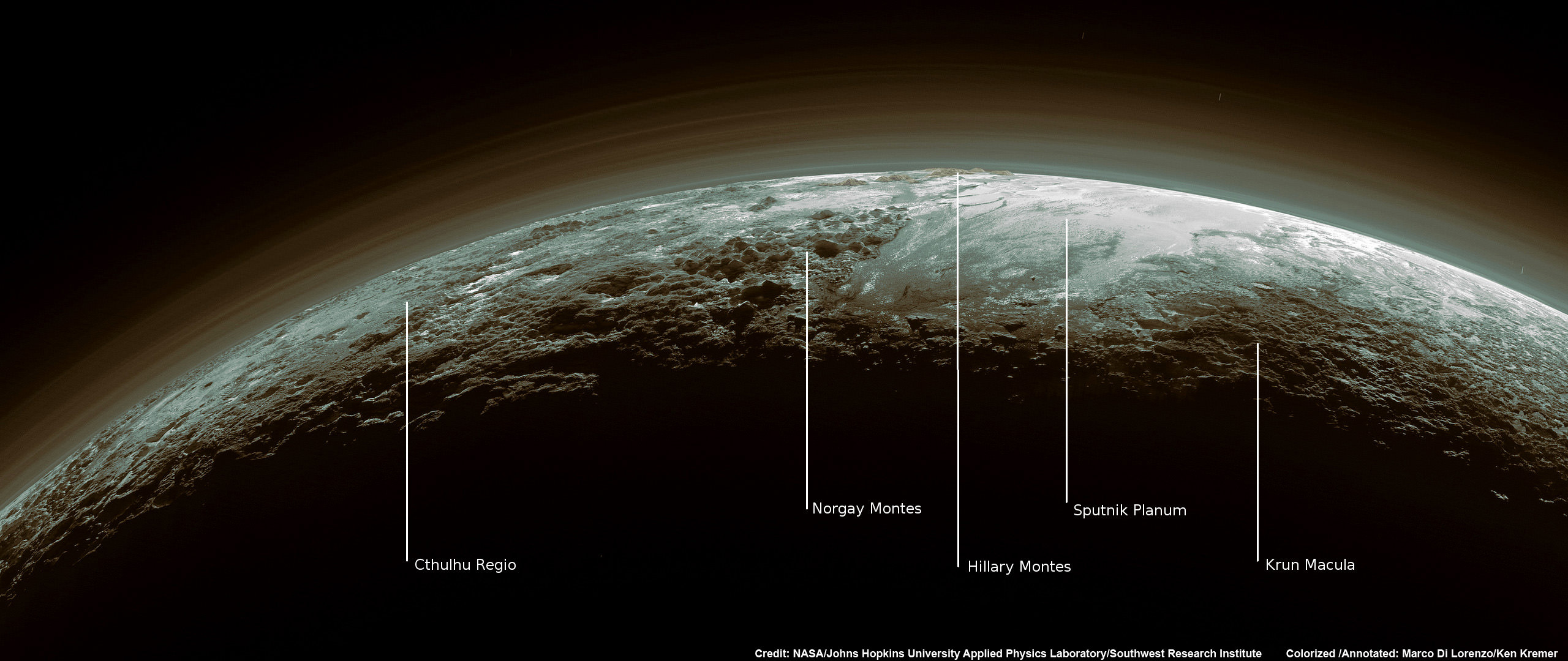
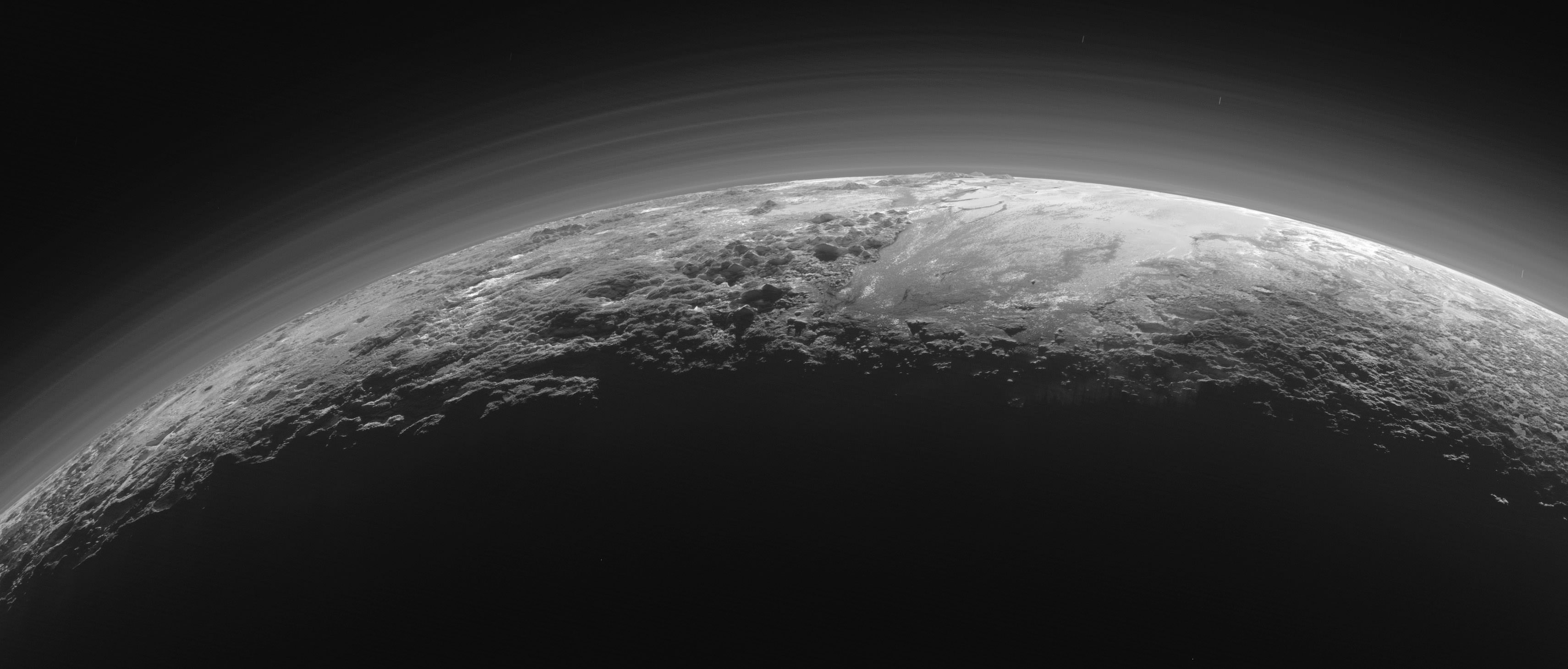
Just 15 minutes after its closest approach to Pluto on July 14, 2015, NASA's New Horizons spacecraft looked back toward the sun and captured this near-sunset view of the rugged, icy mountains and flat ice plains extending to Pluto's horizon - shown in this colorized rendition. The smooth expanse of the informally named icy plain Sputnik Planum (right) is flanked to the west (left) by rugged mountains up to 11,000 feet (3,500 meters) high, including the informally named Norgay Montes in the foreground and Hillary Montes on the skyline. To the right, east of Sputnik, rougher terrain is cut by apparent glaciers. The backlighting highlights more than a dozen layers of haze in Pluto’s tenuous but distended atmosphere. The image was taken from a distance of 11,000 miles (18,000 kilometers) to Pluto; the scene is 780 miles (1,250 kilometers) wide. Credit: NASA/Johns Hopkins University Applied Physics Laboratory/Southwest Research Institute. Colorized/Annotated: Marco Di Lorenzo/Ken Kremer/kenkremer.com
Just 15 minutes after its closest approach to Pluto on July 14, 2015, NASA’s New Horizons spacecraft looked back toward the sun and captured this near-sunset view of the rugged, icy mountains and flat ice plains extending to Pluto’s horizon – shown in this colorized rendition. The smooth expanse of the informally named icy plain Sputnik Planum (right) is flanked to the west (left) by rugged mountains up to 11,000 feet (3,500 meters) high, including the informally named Norgay Montes in the foreground and Hillary Montes on the skyline. To the right, east of Sputnik, rougher terrain is cut by apparent glaciers. The backlighting highlights more than a dozen layers of haze in Pluto’s tenuous but distended atmosphere. The image was taken from a distance of 11,000 miles (18,000 kilometers) to Pluto; the scene is 780 miles (1,250 kilometers) wide. Credit: NASA/Johns Hopkins University Applied Physics Laboratory/Southwest Research Institute. Colorized/Annotated: Marco Di Lorenzo/Ken Kremer/kenkremer.com

Pluto Spectacular! Glaciers, Hazes, Majestic Peaks Revealed in New Photos

Pluto’s Majestic Mountains, Frozen Plains and Foggy Hazes: Just 15 minutes after its closest approach to Pluto on July 14, 2015, NASA’s New Horizons spacecraft looked back toward the sun and captured this near-sunset view of the rugged, icy mountains and flat ice plains extending to Pluto’s horizon. The smooth expanse of the informally named icy plain Sputnik Planum (right) is flanked to the west (left) by rugged mountains up to 11,000 feet (3,500 meters) high, including the informally named Norgay Montes in the foreground and Hillary Montes on the skyline. To the right, east of Sputnik, rougher terrain is cut by apparent glaciers. The backlighting highlights over a dozen layers of haze in Pluto’s tenuous but distended atmosphere. The image was taken from a distance of 11,000 miles (18,000 kilometers) to Pluto; the scene is 780 miles (1,250 kilometers) wide. Credits: NASA/JHUAPL/SwRI

As the hazy, lazy days of summer come to a close, the New Horizons team released a brand new set of incredible images of a very atmospheric Pluto.

Can you believe the detail in these photos? Back-lit by the Sun, we see icy plains, rugged mountains, glacier-cut terrain and multiple layers of haze just like those on a steamy August afternoon.

Closer Look: Majestic Mountains and Frozen Plains: Just 15 minutes after its closest approach to Pluto on July 14, 2015, NASA’s New Horizons spacecraft looked back toward the sun and captured this near-sunset view of the rugged, icy mountains and flat ice plains extending to Pluto’s horizon. The smooth expanse of the informally named Sputnik Planum (right) is flanked to the west (left) by rugged mountains up to 11,000 feet (3,500 meters) high, including the informally named Norgay Montes in the foreground and Hillary Montes on the skyline. The backlighting highlights more than a dozen layers of haze in Pluto’s tenuous but distended atmosphere. The image was taken from a distance of 11,000 miles (18,000 kilometers) to Pluto; the scene is 230 miles (380 kilometers) across. Credits: NASA/JHUAPL/SwRI)
Just look at those pyramidal mountain peaks right next to those relatively smooth, icy plains. The backlighting highlights more than a dozen layers of haze in Pluto’s tenuous but distended atmosphere. The image was taken from a distance of 11,000 miles (18,000 km) to Pluto; the scene is 230 miles (380 km) across.
Credits: NASA/JHUAPL/SwRI)

The scene measures 780 miles (1,250 kilometers) across and was taken from a distance of 11,000 miles (18,000 km) on July 15 just after closest approach. Because backlighting highlights fine aerosols suspended in the atmosphere (think of seeing your breath on a cold winter day against the Sun), these photos show the amazing complexity of Pluto’s atmosphere with more than a dozen thin haze layers extending from near the ground to at least 60 miles (100 km) above the surface.

Near-Surface Haze or Fog on Pluto: In this small section of the larger crescent image of Pluto, taken by NASA’s New Horizons just 15 minutes after the spacecraft’s closest approach on July 14, 2015, the setting sun illuminates a fog or near-surface haze, which is cut by the parallel shadows of many local hills and small mountains. The image was taken from a distance of 11,000 miles (18,000 kilometers), and the width of the image is 115 miles (185 kilometers). Credits: NASA/JHUAPL/SwRI
 In this small section of the larger crescent image of Pluto, the setting sun illuminates a bank of fog or low-lying near-surface haze sliced by the parallel shadows of many local hills and small mountains. The image was taken from a distance of 11,000 miles (18,000 km), and the width of the image is 115 miles (185 km).
Credits: NASA/JHUAPL/SwRI

“This image really makes you feel you are there, at Pluto, surveying the landscape for yourself,” said New Horizons Principal Investigator Alan Stern in a press release today. “But this image is also a scientific bonanza, revealing new details about Pluto’s atmosphere, mountains, glaciers and plains.”

Sputnik Planum is the informal name of the smooth, light-bulb shaped region on the left of this composite of several New Horizons images of Pluto. The brilliantly white upland region to the right may be coated by nitrogen ice that has been transported through the atmosphere from the surface of Sputnik Planum, and deposited on these uplands. The box shows the location of the glacier detail images below. Credits: NASA/JHUAPL/SwRI
Sputnik Planum is the informal name of the smooth, light-bulb shaped region on the left of this composite of several New Horizons images of Pluto. The brilliantly white upland region to the right may be coated by nitrogen ice that has been transported through the atmosphere from the surface of Sputnik Planum, and deposited on these uplands. The box shows the location of the glacier detail images below.
Credits: NASA/JHUAPL/SwRI

I find the hazes the most amazing aspect of the photos. They remind me of crepuscular rays, those beams of sunshine that shine between breaks in the clouds near sunset and sunrise. It chills and thrills me to the bone to see such earthly sights on a bitterly cold orb more than 3 billion miles from home.

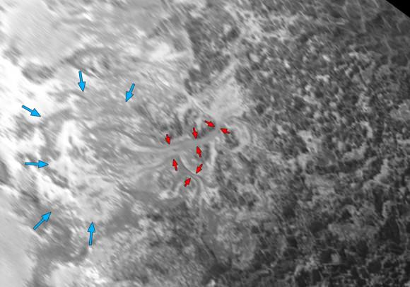
Ice, probably frozen nitrogen, appears to have accumulated on the uplands on the right side of this 390-mile (630-km) wide image is draining from Pluto’s mountains onto the informally named Sputnik Planum through the 2- to 5-mile (3- to 8-km) wide valleys indicated by the red arrows. On Earth this would be considered a valley glacier. The flow front of the ice moving into Sputnik Planum is outlined by the blue arrows. The origin of the ridges and pits on the right side of the image remains uncertain. Credits: NASA/JHUAPL/SwRI
Ice, probably frozen nitrogen, appears to have accumulated on the uplands on the right side of this 390-mile (630-km) wide image is draining from Pluto’s mountains onto the informally named Sputnik Planum through the 2- to 5-mile (3- to 8-km) wide valleys indicated by the red arrows. On Earth this would be considered a valley glacier. The flow front of the ice moving into Sputnik Planum is outlined by the blue arrows. The origin of the ridges and pits on the right side of the image remains uncertain.
Credits: NASA/JHUAPL/SwRI

But that’s not all that’s close to our hearts on Pluto. The photos reveal nitrogen ice apparently flowing downhill from mountainous highlands into a broad, smooth basin. Combined with other recently downloaded pictures, this new image (above) provides evidence for a remarkably Earth-like “hydrological” cycle on Pluto – but involving soft and exotic ices, including nitrogen, rather than water ice.

This might be the most remarkable image of all. Intricate Valley Glaciers on Pluto: This image covers the same region as the image above, but is re-projected from the oblique, backlit view shown in the new crescent image of Pluto. The backlighting highlights the intricate flow lines on the glaciers. The flow front of the ice moving into the informally named Sputnik Planum is outlined by the blue arrows. The origin of the ridges and pits on the right side of the image remains uncertain. This image is 390 miles (630 kilometers) across. Credits: NASA/JHUAPL/SwRI
This might be the most remarkable image of all. It covers the same region as the image above, but is re-projected from the oblique, backlit view shown in the new crescent image of Pluto. The backlighting highlights the intricate flow lines on the valley glaciers. The flow front of the ice moving into the informally named Sputnik Planum is outlined by the blue arrows. We’re looking at a scene 390 miles (630 km) across.
Credits: NASA/JHUAPL/SwRI

Nitrogen ice in the vast, relatively smooth Sputnik Planum may have vaporized in sunlight and then redeposited as ice in the bright, rugged region to its east. The new Ralph imager panorama also reveals glaciers flowing back from the blanketed mountain region into Sputnik Planum; these features are similar to the frozen streams on the margins of ice caps on Greenland and Antarctica.

Who knew that by going to Pluto we’d see such familiarity? But there you have it.

Do Ceres Bizarre Bright Spots Seen in Dazzling New Close Ups Arise from ‘Water Leakage’? Dawn Science Team Talks to UT

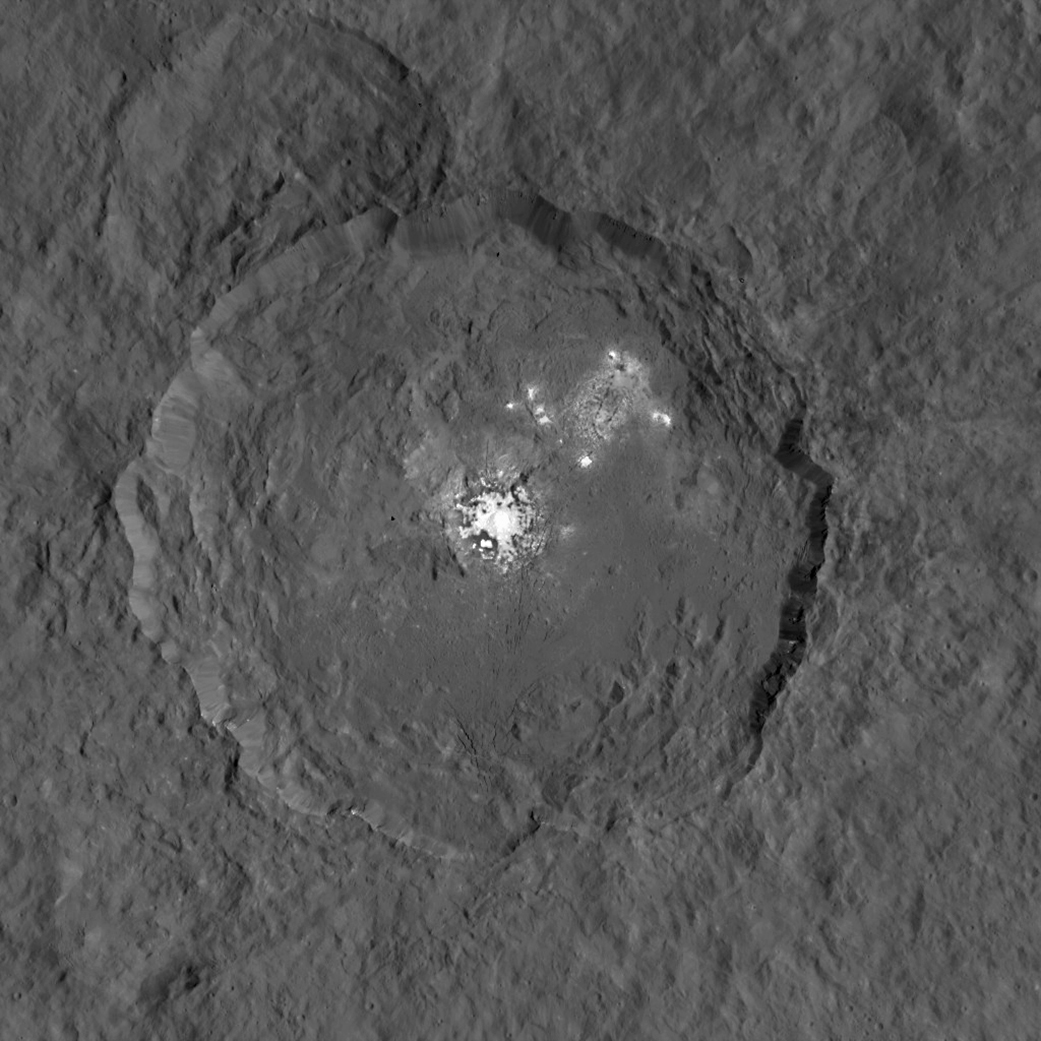
This image, made using images taken by NASA's Dawn spacecraft during the mission's High Altitude Mapping Orbit (HAMO) phase, shows Occator crater on Ceres, home to a collection of intriguing bright spots. Credits: NASA/JPL-Caltech/UCLA/MPS/DLR/IDA

This image, made using images taken by NASA’s Dawn spacecraft during the mission’s High Altitude Mapping Orbit (HAMO) phase, shows Occator crater on Ceres, home to a collection of intriguing bright spots. Credits: NASA/JPL-Caltech/UCLA/MPS/DLR/IDA
Story/imagery updated[/caption]

The question on everyone’s mind about Ceres is what the heck are those bizarre bright spots discovered by NASA’s Dawn orbiter?

Since scientists believe that Ceres occupies a “unique niche” in the solar system and apparently harbors subsurface ice or liquid oceans, could the bright spots arise from subsurface “water leakage?” To find out Universe Today asked Dawn’s Principal Investigator and Chief Engineer.

“The big picture that is emerging is that Ceres fills a unique niche,” Prof. Chris Russell, Dawn principal investigator told Universe Today exclusively.

“Ceres fills a unique niche between the cold icy bodies of the outer solar system, with their rock hard icy surfaces, and the water planets Mars and Earth that can support ice and water on their surfaces,” said Russell, of the University of California, Los Angeles.

And with Dawn recently arrived at its second lowest science mapping orbit of the planned mission around icy dwarf planet Ceres in mid-August, the NASA spacecraft is capturing the most stunningly detailed images yet of those ever intriguing bright spots located inside Occator crater.

The imagery and other science data may point to evaporation of salty water as the source of the bright spots.

“Occasional water leakage on to the surface could leave salt there as the water would sublime,” Russell told me.

Circling the Lights of Occator crater on Ceres.  This image, made using images taken by NASA's Dawn spacecraft during the mission's High Altitude Mapping Orbit (HAMO) phase  and draped over a shape model, shows Occator crater on Ceres, home to a collection of intriguing bright spots.  The image  has been stretched by 1.5 times in the vertical direction to better illustrate the crater's topography.  Credits: NASA/JPL-Caltech/UCLA/MPS/DLR/IDA
Circling the Lights of Occator crater on Ceres. This image, made using images taken by NASA’s Dawn spacecraft during the mission’s High Altitude Mapping Orbit (HAMO) phase and draped over a shape model, shows Occator crater on Ceres, home to a collection of intriguing bright spots. The image has been stretched by 1.5 times in the vertical direction to better illustrate the crater’s topography. Credits: NASA/JPL-Caltech/UCLA/MPS/DLR/IDA

Dawn is Earth’s first probe to explore any dwarf planet and the first to explore Ceres up close. It was built by Orbital ATK.

To shed more light on what still remains rather mysterious even today, NASA has just released the best yet imagery, which was taken at Dawn’s High Altitude Mapping Orbit (HAMO) phase and they raise as many questions as they answer.

Occator has captured popular fascination world-wide because the 60 miles (90 kilometers) diameter crater is rife with the alien bodies brightest spots and whose nature remains elusive to this day, over half a year after Dawn arrived in orbit this past spring on March 6, 2015.

The new imagery from Dawn’s current HAMO mapping orbit was taken at an altitude of just 915 miles (1,470 kilometers). They provide about three times better resolution than the images captured from its previous orbit in June, and nearly 10 times better than in the spacecraft’s initial orbit at Ceres in April and May, says the team.

So with the new HAMO orbit images in hand, I asked the team what’s the latest thinking on the bright spots nature?

Initially a lot of speculation focused on water ice. But the scientists opinions have changed substantially as the data pours in from the lower orbits and forced new thinking on alternative hypotheses – to the absolute delight of the entire team!

“When the spots appeared at first to have an albedo approaching 100%, we were forced to think about the possibility of [water] ice being on the surface,” Russell explained.

“However the survey data revealed that the bright spots were only reflecting about 50% of the incoming light.”

“We did not like the ice hypothesis because ice sublimes under the conditions on Ceres surface. So we were quite relieved by the lower albedo.”

“So what could be 50% reflective? If we look at Earth we find that when water evaporates on the desert it leaves salt which is reflective. We know from its density that water or ice is inside Ceres.”

“So the occasional water leakage on to the surface could leave salt there as the water would sublime even faster than ice.”

At this time no one knows how deep the potential ice deposit or water reservoir sources of the “water leakage” reside beneath the surface, or whether the bright salt spots arose from past or current activity and perhaps get replenished or enlarged over time. To date there is no evidence showing plumes currently erupting from the Cerean surface.

Video Caption: Circling Occator Crater on Ceres. This animation, made using data from NASA’s Dawn spacecraft, shows the topography of Occator crater on Ceres. Credits: Credit: NASA/JPL-Caltech/UCLA/MPS/DLR/IDA/PSI

Dawn is an international science mission and equipped with a trio of state of the art science instruments from Germany, Italy and the US. They will elucidate the overall elemental and chemical composition and nature of Ceres, its bright spots and other wondrous geological features like the pyramidal mountain object.

I asked the PI and Chief Engineer to explain specifically how and which of the instruments is the team using right now at HAMO to determine the bright spots composition?

“The instruments that will reveal the composition of the spots are the framing camera [from Germany], the infrared spectrometer, and the visible spectrometer [both from the VIR instrument from Italy], replied Dr. Marc Rayman, Dawn’s chief engineer and mission director based at NASA’s Jet Propulsion Laboratory, Pasadena, California.

“Dawn arrived in this third mapping orbit [HAMO] on Aug. 13. It began this third mapping phase on schedule on Aug. 17.”

But much work remains to gather and interpret the data and discern the identity of which salts are actually present on Ceres.

“While salts of various sorts have the right reflectance, they are hard to distinguish from one another in the visible,” Russell elaborated to Universe Today.

“That is one reason VIR is working extra hard on the IR spectrum. Scientists are beginning to speculate on the salts. And to think about what salts could be formed in the interior.”

“That is at an early stage right now,” Russell stated.

“I know of nothing exactly like these spots anywhere. We are excited about these scientific surprises!”

Occator crater lies in Ceres northern hemisphere.

“There are other lines of investigation besides direct compositional measurement that will provide insight into the spots, including the geological context,” Rayman told Universe Today.

Each of Dawn’s two framing cameras is also outfitted with a wheel of 7 color filters, explained Joe Makowski, Dawn program manager from Orbital ATK, in an interview.

Different spectral data is gathered using the different filters which can be varied during each orbit.

“So far Dawn has completed 2 mapping orbit cycles of the 6 cycles planned at HAMO.”

Each HAMO mapping orbit cycle lasts 11 days and consists of 14 orbits lasting 19 hours each. Ceres is entirely mapped during each of the 6 cycles. The third mapping cycle just started on Wednesday, Sept. 9.

The instruments will be aimed at slightly different angle in each mapping cycle allowing the team to generate stereo views and construct 3-D maps.

“The emphasis during HAMO is to get good stereo data on the elevations of the surface topography and to get good high resolution clear and color data with the framing camera,” Russell explained.

“We are hoping to get lots of VIR IR data to help understand the composition of the surface better.”

“Dawn will use the color filters in its framing camera to record the sights in visible and infrared wavelengths,” notes Rayman.

“Dawn remains at HAMO until October 23. Then it begins thrusting with the ion propulsion thrusters to reach its lowest mapping orbit named LAMO [Low Altitude Mapping Orbit],” Makowski told me.

“Dawn will arrive at LAMO on December 15, 2015.”

That’s a Christmas present we can all look forward to with glee!

This image was taken by NASA's Dawn spacecraft of dwarf planet Ceres on Feb. 19 from a distance of nearly 29,000 miles (46,000 kilometers). It shows that the brightest spot on Ceres has a dimmer companion, which apparently lies in the same basin. Image Credit:  NASA/JPL-Caltech/UCLA/MPS/DLR/IDA
This image was taken by NASA’s Dawn spacecraft of dwarf planet Ceres on Feb. 19 from a distance of nearly 29,000 miles (46,000 kilometers). It shows that the brightest spot on Ceres has a dimmer companion, which apparently lies in the same basin. Image Credit: NASA/JPL-Caltech/UCLA/MPS/DLR/IDA

What is the teams reaction, interplay and interpretation regarding the mountains of new data being received from Dawn? How do the geologic processes compare to Earth?

“Dawn has transformed what was so recently a few bright dots into a complex and beautiful, gleaming landscape,” says Rayman. “Soon, the scientific analysis will reveal the geological and chemical nature of this mysterious and mesmerizing extraterrestrial scenery.”

“We do believe we see geologic processes analogous to those on Earth – but with important Cerean twists,” Russell told me.

“However we are at a point in the mission where conservative scientists are interpreting what we see in terms of familiar processes. And the free thinkers are imagining wild scenarios for what they see.”

“The next few weeks (months?) will be a time where the team argues amongst themselves and finds the proper compromise between tradition and innovation,” Russell concluded elegantly.

Among the highest features seen on Ceres so far is a mountain about 4 miles (6 kilometers) high, which is roughly the elevation of Mount McKinley in Alaska's Denali National Park.  Vertical relief has been exaggerated by a factor of five to help understand the topography. Credits: NASA/JPL-Caltech/UCLA/MPS/DLR/IDA/LPI
Among the highest features seen on Ceres so far is a mountain about 4 miles (6 kilometers) high, which is roughly the elevation of Mount McKinley in Alaska’s Denali National Park. Vertical relief has been exaggerated by a factor of five to help understand the topography. Credits: NASA/JPL-Caltech/UCLA/MPS/DLR/IDA/LPI

A batch of new results from Dawn at Ceres are expected to be released during science presentations at the European Planetary Science Congress 2015 being held in Nantes, France from 27 September to 2 October 2015.

The Dawn mission is expected to last until at least March 2016, and possibly longer, depending upon fuel reserves.

“It will end some time between March and December,” Rayman told me.

The science objectives in the LAMO orbit could be achieved as soon as March. But the team wants to extend operations as long as possible, perhaps to June or beyond, if the spacecraft remains healthy and has sufficient hydrazine maneuvering fuel and NASA funding to operate.

“We expect Dawn to complete the mission objectives at Ceres by March 2016. June is a the programmatic milestone for end of the nominal mission, effectively a time margin,” Makowski told Universe Today.

“The team is working to a well-defined exploration plan for Ceres, which we expect to accomplish by March, if all goes well.”

“At launch Dawn started with 45 kg of hydrazine. It has about 21 kg of usable hydrazine onboard as of today.”

“We expect to use about 15 kg during the nominal remaining mission,” Makowski stated.

Therefore Dawn may have roughly 5 kg or so of hydrazine fuel for any extended mission, if all goes well, that may eventually be approved by NASA. Of course NASA’s budget depends also on what is approved by the US Congress.

The intriguing brightest spots on Ceres lie in a crater named Occator, which is about 60 miles (90 kilometers) across and 2 miles (4 kilometers) deep.  Vertical relief has been exaggerated by a factor of five. Exaggerating the relief helps scientists understand and visualize the topography much more easily, and highlights features that are sometimes subtle.  Credits: NASA/JPL-Caltech/UCLA/MPS/DLR/IDA/LPI
The intriguing brightest spots on Ceres lie in a crater named Occator, which is about 60 miles (90 kilometers) across and 2 miles (4 kilometers) deep. Vertical relief has been exaggerated by a factor of five. Exaggerating the relief helps scientists understand and visualize the topography much more easily, and highlights features that are sometimes subtle. Credits: NASA/JPL-Caltech/UCLA/MPS/DLR/IDA/LPI

Dawn was launched on September 27, 2007 by a United Launch Alliance (ULA) Delta II Heavy rocket from Space Launch Complex-17B (SLC-17B) at Cape Canaveral Air Force Station, Florida.

Stay tuned here for Ken’s continuing Earth and planetary science and human spaceflight news.

Ken Kremer

Dawn launch on September 27, 2007 by a United Launch Alliance Delta II Heavy rocket from Cape Canaveral Air Force Station, Florida. Credit: Ken Kremer/kenkremer.com
The Journey of Light, From the Stars to Your Eyes

The Milky Way from Earth. Image Credit: Kerry-Ann Lecky Hepburn (Weather and Sky Photography)

This week, millions of people will turn their eyes to the skies in anticipation of the 2015 Perseid meteor shower. But what happens on less eventful nights, when we find ourselves gazing upward simply to admire the deep, dark, star-spangled sky? Far away from the glow of civilization, we humans can survey thousands of tiny pinpricks of light. But how? Where does that light come from? How does it make its way to us? And how do our brains sort all that incoming energy into such a profoundly breathtaking sight?

Our story begins lightyears away, deep in the heart of a sun-like star, where gravity’s immense inward pressure keeps temperatures high and atoms disassembled. Free protons hurtle around the core, occasionally attaining the blistering energies necessary to overcome their electromagnetic repulsion, collide, and stick together in pairs of two.

2000px-FusionintheSun.svg
Proton-proton fusion in a sun-like star. Credit: Borb

So-called diprotons are unstable and tend to disband as quickly as they arise. And if it weren’t for the subatomic antics of the weak nuclear force, this would be the end of the line: no fusion, no starlight, no us. However, on very rare occasions, a process called beta decay transforms one proton in the pair into a neutron. This new partnership forms what is known as deuterium, or heavy hydrogen, and opens the door to further nuclear fusion reactions.

Indeed, once deuterium enters the mix, particle pileups happen far more frequently. A free proton slams into deuterium, creating helium-3. Additional impacts build upon one another to forge helium-4 and heavier elements like oxygen and carbon.

Such collisions do more than just build up more massive atoms; in fact, every impact listed above releases an enormous amount of energy in the form of gamma rays. These high-energy photons streak outward, providing thermonuclear pressure that counterbalances the star’s gravity. Tens or even hundreds of thousands of years later, battered, bruised, and energetically squelched from fighting their way through a sun-sized blizzard of other particles, they emerge from the star’s surface as visible, ultraviolet, and infrared light.

Ta-da!

But this is only half the story. The light then has to stream across vast reaches of space in order to reach the Earth – a process that, provided the star of origin is in our own galaxy, can take anywhere from 4.2 years to many thousands of years! At least… from your perspective. Since photons are massless, they don’t experience any time at all! And even after eluding what, for any other massive entity in the Universe, would be downright interminable flight times, conditions still must align so that you can see even one twinkle of the light from a faraway star.

That is, it must be dark, and you must be looking up.

Credit: Bruce Blaus
Credit: Bruce Blaus

The incoming stream of photons then makes its way through your cornea and lens and onto your retina, a highly vascular layer of tissue that lines the back of the eye. There, each tiny packet of light impinges upon one of two types of photoreceptor cell: a rod, or a cone.

Most photons detected under the low-light conditions of stargazing will activate rod cells. These cells are so light-sensitive that, in dark enough conditions, they can be excited by a single photon! Rods cannot detect color, but are far more abundant than cones and are found all across the retina, including around the periphery.

The less numerous, more color-hungry cone cells are densely concentrated at the center of the retina, in a region called the fovea (this explains why dim stars that are visible in your side vision suddenly seem to disappear when you attempt to look at them straight-on). Despite their relative insensitivity, cone cells can be activated by very bright starlight, enabling you to perceive stars like Vega as blue and Betelgeuse as red.

But whether bright light or dim, every photon has the same endpoint once it reaches one of your eyes’ photoreceptors: a molecule of vitamin A, which is bound together with a specialized protein called an opsin. Vitamin A absorbs the light and triggers a signal cascade: ion channels open and charged particles rush across a membrane, generating an electrical impulse that travels up the optic nerve and into the brain. By the time this signal reaches your brain’s visual cortex, various neural pathways are already hard at work translating this complex biochemistry into what you once thought was a simple, intuitive, and poetic understanding of the heavens above…

The stars, they shine.

So the next time you go outside in the darker hours, take a moment to appreciate the great lengths it takes for just a single twinkle of light to travel from a series of nuclear reactions in the bustling center of a distant star, across the vastness of space and time, through your body’s electrochemical pathways, and into your conscious mind.

It gives every last one of those corny love songs new meaning, doesn’t it?

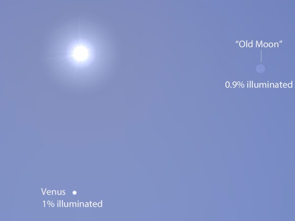
See Venus at Her Most Ravishing

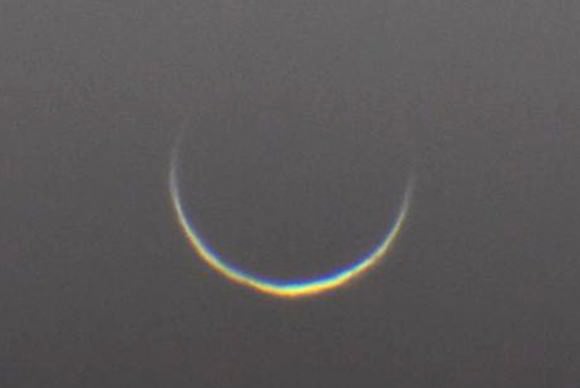
Venus dwindles to a captivating crescent nearly 1 arc minute across as seen on August 8, 2015. An infrared filter was used to increase contrast between the planet and otherwise bright sky. Credit: SEN / Damian Peach

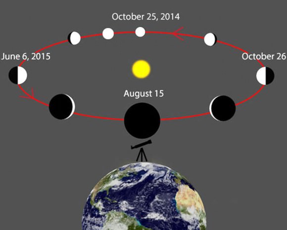
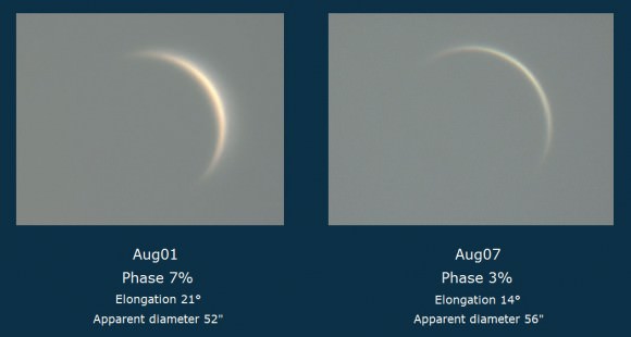
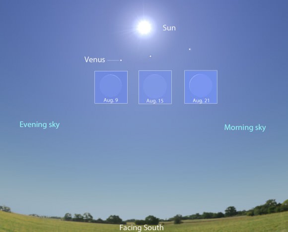
Venus is HUGE right now but oh-so-skinny as it approaches inferior conjunction on August 15. Like crescents? You’ll never see a thinner and more elegant one, but first you’ll have to find it. Here’s how.

On August 9th, Venus is only 6 days before inferior conjunction when it passes between the Earth and Sun. Shortly before, during and after conjunction, Venus will appear as a wire-thin crescent. Venus will continue moving west of the Sun and rise higher in the morning sky after mid-August with greatest elongation west occuring on October 26. Wikipedia with additions by the author
On August 9th, Venus is only 6 days before inferior conjunction when it passes between the Earth and Sun. Shortly before, during and after conjunction, Venus will appear as a wire-thin crescent. The planet will continue moving west of the Sun and rise higher in the morning sky after mid-August with greatest elongation west occurring on October 26, when its phase will fatten to half.
Wikipedia with additions by the author

There’s only one drawback to enjoying Venus at its radically thinnest — it’s very close to the Sun and visible only during the daytime. A look at the diagram above reveals that as Venus and Earth draw closer, the planet also aligns with the Sun. At conjunction on August 15, it will pass 7.9° south of our star, appearing as an impossibly thin crescent in the solar glare. The sight is unique, a curved strand of incandescent wire burning in the blue.

Venus at inferior conjunction on January 10, 2014 shows both the sunlit crescent and cusp extensions from sunlight penetrating the atmosphere from behind. Credit: Tudorica Alexandru
Venus at inferior conjunction on January 10, 2014 shows both the sunlit crescent and cusp extensions caused by sunlight penetrating the atmosphere from behind. During this previous inferior conjunction, Venus passed north of the Sun, so we see the bottom of the crescent illuminated. Credit: Tudorica Alexandru

If you’re patient and the air is steady, you might even glimpse the cusps of the illuminated crescent extending beyond their normal length to partially or even completely encircle Venus’s disk. These thread-like extensions become visible when the planet lies almost directly between us and the Sun. Sunlight scatters off the Venus’s dense atmosphere, causing it to glow faintly along the limb. One of the most remarkable sights in the sky, the sight is testament to the thickness of the planet’s airy envelope.

Going, going, gone! Or almost. Venus photographed in its beautiful crescent phase on two occasions this past week.
Going, going, gone! Venus photographed in its beautiful crescent phase on two occasions last week. When the planet reaches inferior conjunction this Saturday (August 15),  the crescent will expand to nearly 1 arc minute across. No planet comes closer to Earth than Venus — just 27 million miles this week. Credit: Giorgio Rizzarelli

Today, only 1.7% of the planet is illuminated by the Sun, which shines some 11° to the northwest. The Venusian crescent spans 57 arc seconds from tip to tip, very close to 1 arc minute or 1/30 the width of the Full Moon. Come conjunction day August 15, those numbers will be 0.9% and 58 arc seconds. The angular resolution of the human eye is 1 minute, implying that the planet’s shape might be within grasp of someone with excellent eyesight under a clear, clean, cloudless sky. However — and this is a big however — a bright sky and nearby Sun make this practically impossible.

No worries though. Even 7x binoculars will nail it; the trick is finding Venus in the first place. For binocular users,  hiding the Sun COMPLETELY behind a building, chimney, power pole or tree is essential. The goddess lurks dangerously close to our blindingly-bright star, so you must take every precaution to protect your eyes. Never allow direct sunlight into your glass. Never look directly at the Sun – even for a second – with your eyes or UV and infrared light will sear your retinas. You can use the map provided, which shows several locations of the planet at 1 p.m. CDT when it’s highest in the sky, to help you spot it.

The Sun's position is shown for 1 p.m. local daylight time, while Venus is shown for three dates - today, conjunction date and Aug. 21. As Venus moves from left to right under or south of the Sun, its phase swings from evening crescent (left) to morning crescent from our perspective on Earth. Source: Stellarium with additions by the author
The Sun’s position is shown for 1 p.m. local daylight time facing due south, while Venus and its corresponding phase is depicted before, at and after conjunction. As Venus moves from left to right south of the Sun, its phase changes from evening crescent (left) to morning crescent from our perspective on Earth. Source: Stellarium with additions by the author

If you’d like to see Venus on a different day or time, download a free sky-charting program like Stellarium or Cartes du Ciel. With Stellarium, open the Sky and Viewing Options menu (F4) and click the Light Pollution Level option down to “1” to show Venus in a daytime sky. Pick a viewing time, note Venus’s orientation with respect to the Sun (which you’ve hidden of course!) and look at that spot in the sky with binoculars. I’ll admit, it’s a challenging observation requiring haze-free skies, but be persistent.

By coincidence, the Moon and Venus will be about the same distance from the Sun and appear as exceedingly thin crescents on the afternoon (CDT) of August 13. Source: Stellarium
By coincidence, the Moon and Venus will be about the same distance from the Sun and appear as very similar thin crescents around 1 p.m. CDT on August 13.  Venus should still be visible using the methods described below, but the Moon will be impossible to see. Source: Stellarium

A safer and more sure-fire way to track the planet down involves using those setting circles on your telescope mount most of us never bother with. First, find the celestial coordinates (right ascension and declination) of the Sun and Venus for the time you’d like to view. For example, let’s say we want to find Venus on August 10 at 2 p.m. Using your free software, you click on the Sun and Venus’s positions for that time of day to get their coordinates, in this case:

Venus – Right ascension 9h 42 minutes, declination +6°.
Sun – RA 9h 22 minutes, dec. +15° 30 minutes

Now subtract the two to get Venus’ offset from the Sun = 20 minutes east, 9.5° south.

Dust off those setting circles (declination shown here) and use them to point you to Venus this week. Credit: Bob King
Dust off those setting circles (declination shown here, marked off in degrees) and use them to point you to Venus this week. Credit: Bob King

Next, polar align your telescope using a compass and then cover the objective end with a safe mylar or glass solar filter. Center and sharply focus the Sun in the telescope. Now, loosen the RA lock and carefully offset the right ascension 20 minutes east using your setting circle, then re-lock. Do the same with declination, pointing the telescope 9.5° south of the Sun. If you’re polar alignment is reasonably good, when you remove the solar filter and look through the eyepiece, you should see Venus staring back at you from a blue sky. If you see nothing at first, nudge it a little this way and that to bring the planet into view.

Sometimes it takes me a couple tries, but I eventually stumble arrive on target. Obviously, you can also use this technique to spot Mercury and Jupiter in the daytime, too. By the way, don’t worry what the RA and Dec. read on your setting circles when you begin your hunt; only the offset’s important.

When inferior conjunction occurs at the same time Venus crosses the plane of Earth's orbit, we see a rare transit like this one on June 5, 2012. Credit: Bob King
When inferior conjunction occurs at the same time Venus crosses the plane of Earth’s orbit, we see a rare transit (upper right) like this one on June 5, 2012. Credit: Bob King

This year’s conjunction is one of the best for finding Venus in daylight because it’s relatively far from the Sun. With an orbital inclination of 3.2°, Venus’s position can range up to 8° north and south of the Earth’s orbital plane or ecliptic. Rarely does the planet cross the ecliptic at the same time as inferior conjunction. When it does, we experience a transit of VenusTransits always come in pairs; the last set occurred in 2004 and 2012; the next will happen over 100 years from now in 2117 and 2125.

I hope you’re able to make the most of this opportunity while still respecting your tender retinas. Good luck!