“The Hobbit” Author Gets a Crater on Mercury

Here’s a little something to please fans of space, art and fantasy alike (and those who enjoy all three): on August 6 the International Astronomical Union approved names for 9 craters on Mercury, one of which is named for J.R.R. Tolkien, revered author of The Hobbit and The Lord of the Rings (among other seminal fantasy works.)

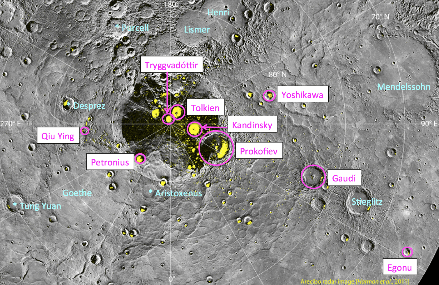
The crater Tolkien is approximately 30 miles (48 km) in diameter. All 9 newly-named craters are located in Mercury’s north polar region and exhibit radar evidence of water ice hidden in their shadowy pocketses.

IAU procedure for craters on Mercury has them named after “deceased artists, musicians, painters, and authors who have made outstanding or fundamental contributions to their field and have been recognized as art historically significant figures for more than 50 years.” Find out who all 9 new craters are named for after the jump:

Egonu, for Uzo Egonu (1931-1996), a Nigerian-born painter who at 13 was sent to England to study art, first at a private school in Norfolk and later at the Camberwell School of Arts and Crafts. Exile, alienation, and the pain of displaced peoples were recurrent themes in his work.

Gaudí­, after Antoni Gaudí­ (1852-1926), a Spanish architect whose work concentrated largely on the Catalan capital of Barcelona. He was very skilled with ceramics, stained glass, wrought-iron forging, and carpentry and integrated these crafts into his architecture.

Kandinsky, for Wassily Kandinsky (1866-1944), a Russian painter and art theorist credited with painting the first purely abstract works.

Petronius, for Titus Petronius (c. AD 27-66), a Roman courtier during the reign of Nero. He is generally believed to be the author of the Satyricon, a satirical novel believed to have been written during the Neronian era.

Prokofiev, for Sergei Prokofiev (1891-1953), a Russian composer, pianist, and conductor who is considered one of the major composers of the 20th century. His best-known works include the ballet Romeo and Juliet — from which “Dance of the Knights” is taken — and Peter and the Wolf.

Tolkien, for John Ronald Reuel (J. R. R.) Tolkien (1892-1973), an English writer, poet, philologist, and university professor, best known as the author of the classic fantasy novels The Hobbit and The Lord of the Rings.

Tryggvadóttir, for Nina Tryggvadóttir (1913-1968), one of Iceland’s most important abstract expressionist artists and one of very few Icelandic female artists of her generation. She primarily worked in painting, but she also created collages, stained glass work, and mosaics.

Qiu Ying, for Shifu Qiu Ying (1494-1552), a Chinese painter who specialized in the gongbi brush technique, a careful realist method in Chinese painting. He is regarded as one of the Four Great Masters of the Ming Dynasty.

Yoshikawa, for Eiji Yoshikawa (1892-1962), a Japanese historical novelist best known for his revisions of older classics including The Tale of the Heike, Tale of Genji, Outlaws of the Marsh, and Romance of the Three Kingdoms.

“These designations expand the opportunities to recognize the contributions to the arts by the most creative individuals from many cultures and eras. The names of those individuals are now linked in perpetuity to the innermost planet.”

– Sean Solomon, MESSENGER Principal Investigator

The craters were imaged by NASA’s MESSENGER spacecraft, currently in extended mission around Mercury. Learn more about the preciousss MESSENGER mission here. (Gollum! Gollum!)

Image credit: NASA/Johns Hopkins University Applied Physics Laboratory/Carnegie Institution of Washington 

Curiosity sees Mount Sharp Up Close and gets ‘Brain Transplant’

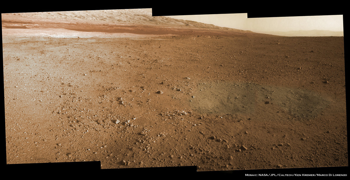
Image Caption: Mosaic of Mount Sharp inside Curiosity’s Gale Crater landing site. Gravelly rocks are strewn in the foreground, dark dune field lies beyond and then the first detailed view of the layered buttes and mesas of the sedimentary rock of Mount Sharp. Topsoil at right was excavated by the ‘sky crane’ landing thrusters. Gale Crater in the hazy distance. This mosaic was stitched from three full resolution Navcam images returned by Curiosity on Sol 2 (Aug 8) and colorized based on Mastcam images from the 34 millimeter camera. Processing by Ken Kremer and Marco Di Lorenzo. Credit: NASA/JPL-Caltech/Ken Kremer/Marco Di Lorenzo

The Curiosity rover has beamed back the first detailed images of Mount Sharp, offering a stupendous initial view of her ultimate driving goal, and is now in the midst of a crucial “brain transplant” this weekend that will transform her into a fully operational rover.

The science team will direct the six-wheeled Curiosity to begin climbing Mount Sharp at some later date during the rovers’ two year primary mission after traversing and extensively investigating the floor of her landing site inside Gale Crater.

See our mosaic focusing on the base of Mount Sharp using three full resolution images snapped by the Navcam navigation camera located on the newly erected camera and instrument mast with colorization based on the 34 millimeter Mastcam color camera.

Curiosity came to rest almost flat on the martian surface, but with a slight 3 degree tilt down in the front and the images thus far are taken from that preprogrammed viewpoint, roughly some six miles or so from the base of Mount Sharp.

The terrain is strewn with small pebbles that may stem from a nearby alluvial fan through which liquid water flowed long ago, scientist think. Observations from orbit with NASA’s Mars Reconnaissance Orbiter have identified clay and sulfate minerals in the lower layers of Mount Sharp, indicating a wet history. At higher elevations, scientists hope to discover a boundary layer and indications of what led to the “Great Dessication Event” and loss of liquid water on the ancient Martian surface.

This weekend Curiosity has also begun transmitting spectacular hi res Mastcam images that will far exceed anything else thus far. Here is the Mastcam 360 pano as assembled by NASA so far:

Image Caption: First Hi-Res Color Mosaic of Curiosity’s Mastcam Images. NASA/JPL-Caltech/MSSS

But before the car-sized robot can actually rove around, reach out with her 7 foot (2 meter) long instrument loaded arm and scoop up samples for analysis by the on board chemistry labs she needs the software smarts to accomplish the science tasks.

With all the initial post landing objectives accomplished, engineers at NASA’s Jet Propulsion Lab in Pasadena, Calif., are spending 4 Sols, or Martian days, bracketing this weekend to upload a new software package named “R10” that is optimized for surface operations and will replace the current “R9” package.

“We designed the mission from the start to be able to upgrade the software as needed for different phases of the mission,” said Ben Cichy of NASA’s Jet Propulsion Laboratory in Pasadena, Calif., chief software engineer for the Mars Science Laboratory mission. “The flight software version Curiosity currently is using [R9] was really focused on landing the vehicle. It includes many capabilities we just don’t need any more. It gives us basic capabilities for operating the rover on the surface, but we have planned all along to switch over after landing to a version of flight software that is really optimized for surface operations.”

Software on both the primary and backup computers is being carefully upgraded in step by step stages. He said an initial “toe dip” on Friday to test the upgrade was the first step.

“R10 is optimized for surface operations and has what the science team wants. It’s being downloaded over the next four Sols to enable this fantastic mission,” Cichy said at a JPL news briefing on August 10. They will stand down on science for the next four Sols during the installation.

“Right now, we have the capability in our basic surface software to check out the health of the instruments, but we don’t really have the capability to go and make the full use of all this great hardware we shipped to Mars.”

“So the R10 software gives us the capability to use the robotic arm fully, to use the drill, to use the dust removal tool, to use the whole sampling chain and injest the samples and analyze them, all this exciting stuff this mission will do.”

“Curiosity is a Martian mega rover and born to drive ! R10 gives us the ability to drive autonomously and use images to detect hazards and drive safely.”

So far, the software upgrade is going as planned this weekend.

Curiosity made an unprecedented pinpoint landing inside Gale Crater on Aug. 5/6 using the rocket powered “Sky Crane” descent stage that lowered Curiosity by cables onto the Red Planet’s surface exactly as planned on the plains astride Mount Sharp just a few miles from the base of the gigantic mountain.

Mount Sharp covers much of the interior of the 96 mile wide (154 km) Gale Crater. The peak of the 3.4 mile (5.5 km) high layered mountain is taller than Mount Whitney in California.

For comparison, see Curiosity’s initial wider field post-landing shots of Mount Sharp in 2 D and 3 D from the lower resolution fish-eye Hazcam cameras, here

NASA’s 1 ton mega rover Curiosity is the biggest and most complex robot ever sent to the surface of another planet, sporting a payload of 10 state of the art science instruments weighing 15 times more than any prior roving vehicle. Curiosity’s goal is to determine if Mars was ever capable of supporting microbial life, past or present and to search for the signs of life in the form of organic molecules.

Ken Kremer

Curiosity and the Mojave Desert of Mars – Panorama from Gale Crater

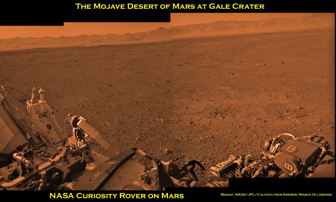
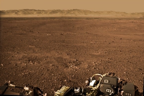
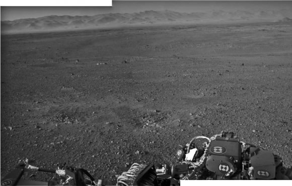
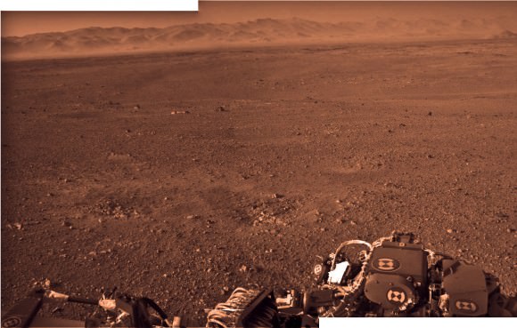
Image Caption: Curiosity and the Mojave Desert of Mars at Gale Crater North Rim, False Color Mosaic. This false color panoramic mosaic shows Curiosity in the foreground looking to the eroded rim of Gale Crater in the background. Visible at left is a portion of the RTG nuclear power source, low gain antenna pointing up, then the deployed High Gain antenna and other components of the rover deck. This mosaic was assembled from the three new full resolution Navcam images returned by Curiosity overnight and snapped on Sol 2 on Aug. 8. Image stitching by Ken Kremer and Marco Di Lorenzo. Topsoil at right foreground has been excavated by the descent landing thrusters to expose what the team believes is bedrock. See black and white version below. Credit: NASA/JPL-Caltech/Ken Kremer/Marco Di Lorenzo

Curiosity lead scientist John Grotzinger calls this place “The Mojave Desert” of Mars– that’s the sweet spot where NASA’s huge new Curiosity rover landed only 3 Sols, or days ago, and looks so “Earth-like”.

See above and below our new 3 frame panoramic mosaic showing Curiosity with a dramatic “Mojave Desert” backdrop – in false color and black and white – assembled from new pictures received overnight at JPL.

With her camera mast erected, Curiosity is beginning to beam back a flood of spectacular images and giving us the first detailed view of her new surroundings from her touchdown point inside Gale Crater on Mars beside a 3.4 mile (5.5 km) high layered mountain nicknamed Mount Sharp.

Overnight, Curiosity sent back many more full frame pictures from her Navcam navigation camera, including exquisite high resolution views of herself with the eroded rim of Gale Crater over her shoulder.

At Wednesday’s briefing, Grotzinger has ecstatic with the initial set of high resolution images showing Gale crater in the distance, saying;

“The thing that really struck the science team about this image, you would really be forgiven for thinking that NASA was trying to pull a fast one on you and we actually put a rover out in the Mojave Desert and took a picture.

“That’s the part of the rim that’s lowest in elevation, facing the northern lowlands of Mars.”

“The thing that’s amazing about this is to a certain extent the first impression you get is how earth-like this seems, looking at that landscape.”

The terrain is strewn with small pebbles that the team hypothesizes may stem from a nearby alluvial fan through which liquid water flowed long ago and is exactly why they chose Gale Crater as Curiosity’s landing site.

“The sedimentary materials, all those materials are derived from erosion of those mountains there, that’s the source region for this material,” Grotzinger said. “It’s really kind of fantastic.”

The first 360 color panorama from the Mastcam cameras are expected soon.

Ken Kremer

Image Caption: Curiosity and the Mojave Desert of Mars at Gale Crater North Rim. This false color panoramic mosaic shows Curiosity in the foreground looking to the eroded rim of Gale Crater in the background. Visible at left is a portion of the RTG nuclear power source, low gain antenna pointing up, then the deployed High Gain antenna and other components of the rover deck. This mosaic was assembled from the three new full resolution Navcam images returned by Curiosity overnight. Processing by Ken Kremer and Marco Di Lorenzo. Topsoil at right foreground has been excavated by the descent landing thrusters to expose what the team believes is bedrock. Credit: NASA/JPL-Caltech/Ken Kremer/Marco Di Lorenzo

Image Caption: Looking to Martian bedrock and Gale Crater North Rim, False Color- This two frame mosaic was assembled from the first two full resolution Navcam images returned by Curiosity on Sol 2 (Aug 8) and enhanced and colorized to bring out further details. Image sticthing and processing by Ken Kremer and Marco Di Lorenzo. Topsoil in the foreground has been excavated by the Sky crane descent landing thrusters to expose what the team believes is bedrock. Credit: NASA/JPL-Caltech/Ken Kremer/Marco Di Lorenzo – www.kenkremer.com

Curiosity raises Mast and snaps 1st Self Portrait and 1st 360 Panorama

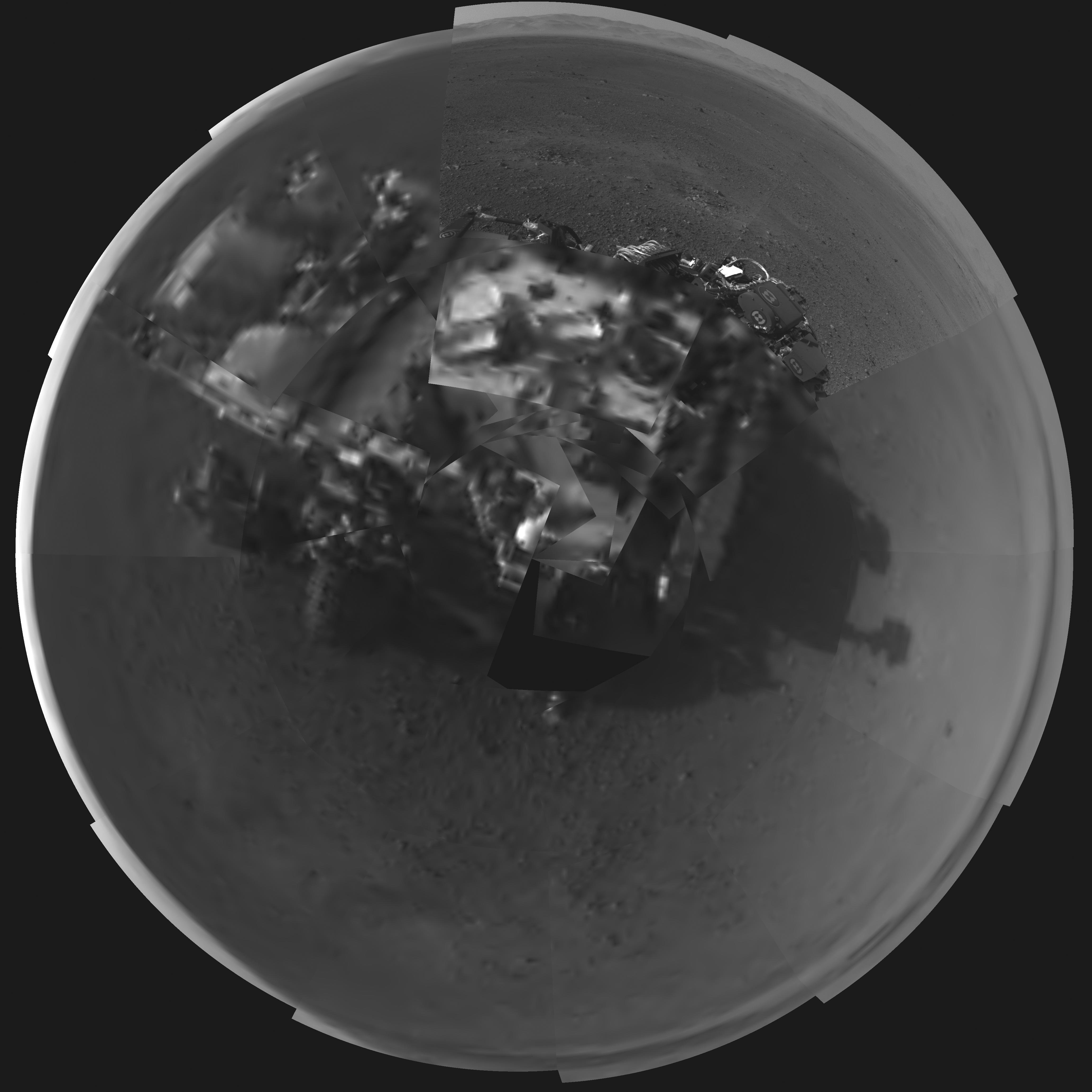
Image Caption: Rover’s Self Portrait -This Picasso-like self portrait of NASA’s Curiosity rover was taken by its Navigation cameras, located on the now-upright mast. The camera snapped pictures 360-degrees around the rover, while pointing down at the rover deck, up and straight ahead. Those images are shown here in a polar projection. Most of the tiles are thumbnails, or small copies of the full-resolution images that have not been sent back to Earth yet. Two of the tiles are full-resolution. Credit: NASA/JPL-Caltech.
See below the 1st 360 degree panorama from Curiosity and an enhanced Sol 2 mosaic of the full resolution view of the north rim of Gale Crater by this author

The rover Curiosity continues her marathon run of milestone achievements – snapping her 1st self portrait and 1st 360 degree panorama since touchdown inside Gale Crater barely over 2 sols, or Martian days ago.

To take all these new images, Curiosity used a new camera, the just-activated higher resolution navigation cameras (Navcam) positioned on the mast. Several of the new images provide the best taste yet of the stupendous vistas coming soon. See our enhanced Sol 2 mosaic below.

The 3.6 foot-tall (1.1 meter) camera mast on the rover deck was just raised and activated earlier today, Wednesday, Aug. 8.

The mast deployment is absolutely crucial to Curiosity’s science mission. It is also loaded with the high resolution MastCam cameras and the ChemCam instrument with the laser rock zapper.

Most of the images Navcam images beamed back today were lower-resolution thumbnails. But 2 high-resolution Navcams from the panorama and the self portrait were also downlinked and provide the clearest view yet of the breathtaking terrain surrounding Curiosity in every direction.

“The full frame navcams show the north rim of Gale Crater,” said Justin Maki, MSL navcam lead, at a briefing today at JPL. “The Navcam’s are identical to the MER Navcam’s.”

The hi res images also show how the descent thruster excavated the topsoil like Phoenix.

Image Caption: Curiosity Looks Away from the Sun – This is the first 360-degree panoramic view from NASA’s Curiosity rover, taken with the Navigation cameras. Most of the tiles are thumbnails, or small copies of the full-resolution images that have not been sent back to Earth yet. Two of the tiles near the center are full-resolution. Mount Sharp is to the right, and the north Gale Crater rim can be seen at center. The rover’s body is in the foreground, with the shadow of its head, or mast, poking up to the right. These images were acquired at 3:30 pm on Mars, or the night of Aug. 7 PDT (early morning Aug. 8 EDT). Thumbnails are 64 by 64 pixels in size; and full-resolution images are 1024 by 1024 pixels. Credit: NASA/JPL-Caltech

Image Caption: Looking to Martian bedrock and Gale Carter North Rim, Enhanced Mosaic- This mosaic was assembled from the first two full resolution Navcam images returned by Curiosity on Sol 2 (Aug 8) and enhanced to bring out further details. Processing by Ken Kremer and Marco Di Lorenzo. Topsoil in the foreground has been excavated by the descent landing thrusters to expose what the team believes is bedrock. Credit: NASA/JPL-Caltech/Ken Kremer/Marco di Lorenzo

“These Navcam images indicate that our powered descent stage did more than give us a great ride, it gave our science team an amazing freebie,” said John Grotzinger, project scientist for the mission from the California Institute of Technology in Pasadena. “The thrust from the rockets actually dug a one-and-a-half-foot-long [0.5-meter] trench in the surface. It appears we can see Martian bedrock on the bottom. Its depth below the surface is valuable data we can use going forward.”

Gale Crater is unlike anything we’ve seen before on Mars.

It also distinctly reminded Grotzinger of Earth and looked to him like the rover set down in the Mojave desert. “The thing that’s amazing about this is to a certain extent the first impression you get is how earth-like this seems, looking at that landscape.”

Curiosity carries 10 science instruments with a total mass 15 times as large as the science payloads on NASA’s Mars rovers Spirit and Opportunity. Some of the tools, such as a laser-firing instrument for checking rocks’ elemental composition from a distance, are the first of their kind on Mars. Curiosity will use a drill and scoop, which are located at the end of its robotic arm, to gather soil and powdered samples of rock interiors, then sieve and parcel out these samples into the rover’s analytical laboratory instruments.

So far everything is going very well with Curiosity’s mechanical and instrument checkout. And there is even more power than expected from the RTG nuclear power source.

“We have more power than we expected and that’s going to be fantastic for being able to keep the rover awake longer,” said Mission manager Jennifer Trosper of JPL.

Ken Kremer

Looking to Martian bedrock and Gale Carter North Rim, Enhanced Mosaic with False Color- This mosaic was assembled from the first two full resolution Navcam images returned by Curiosity on Sol 2 (Aug 8) and enhanced and colorized to bring out further details. Processing by Ken Kremer and Marco Di Lorenzo. Topsoil in the foreground has been excavated by the descent landing thrusters to expose what the team believes is bedrock. Credit: NASA/JPL-Caltech/Ken Kremer/Marco di Lorenzo

Mount Sharp on Mars: 1st 2-D and 3-D Views of Curiosity’s Ultimate Mountain Goal

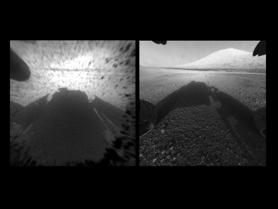
Image Caption: Clear View on Mars – This image comparison shows a view through a Hazard-Avoidance camera on NASA’s Curiosity rover before and after the clear dust cover was removed. Both images were taken by a camera at the front of the rover. Mount Sharp, the mission’s ultimate destination, looms ahead. See the first 3 D and 2 D full res images with no dust cover, below. Image credit: NASA/JPL-Caltech

Curiosity, NASA’s new car sized rover on Mars has sent back her first breathtaking views of Mount Sharp, the huge nearby mountain that enticed scientists to set Gale Crater as her touchdown goal.

And already within the first 2 Sols, or martian days, the rover has beamed back magnificent 2D and 3 D vistas of the landscape surrounding her.

The unprecedented rocket powered “Sky Crane” descent maneuver that lowered Curiosity by cables upon the Red Planet’s surface rover with pinpoint accuracy, set her down in a position inside Gale Crater that fortuitously pointed her front Hazard Avoidance (Hazcam) cameras towards a stupendous panoramic view of Mount Sharp.

The terrain is strewn with small pebbles that may stem from a nearby alluvial fan through which liquid water flowed long ago, scientist think.

The top image set shows the spectacular side by side views of Mount Sharp before and after the protective dust covers were popped off.

Mount Sharp is taller than Mount Ranier, the tallest mountain in the US in the lower 48 states. It’s about 3.5 miles (5.5 km) high.

Curiosity is roughly 6 km distant from Mount Sharp, as the martian crow flies.

The image below is the first full resolution Hazcam version of Mount Sharp.

Curiosity’s Early Views of Mars. This full-resolution image shows one of the first views from NASA’s Curiosity rover, which landed on Mars the evening of Aug. 5 PDT (early morning hours Aug. 6 EDT). It was taken through a “fisheye” wide-angle lens on one of the rover’s front Hazard-Avoidance cameras. These engineering cameras are located at the rover’s base. Image credit: NASA/JPL-Caltech

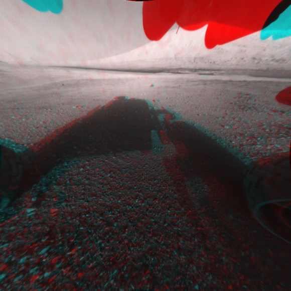
Here’s the first 3D version of Mount Sharp assembled from both front cameras.

Image Caption: 3-D View from the Front of Curiosity. This image is a 3-D view in front of NASA’s Curiosity rover, which landed on Mars on Aug. 5 PDT (Aug. 6 EDT). The anaglyph was made from a stereo pair of Hazard-Avoidance Cameras on the front of the rover. Mount Sharp, a peak that is about 5.5 kilometers (3.4 miles) high, is visible rising above the terrain, though in one “eye” a box on the rover holding the drill bits obscures the view. This image was captured by Hazard-Avoidance cameras on the front of the rover at full resolution shortly after the rover landed. It has been linearized to remove the distorted appearance that results from its fisheye lens. Credit: NASA/JPL-Caltech

Ken Kremer

Winds of Change at the Edge of the Solar System

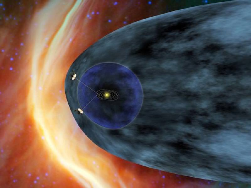
As the venerable Voyager 1 spacecraft hurtles ever outward, breaking through the very borders of our solar system at staggering speeds upwards of 35,000 mph, it’s sending back information about the curious region of space where the Sun’s outward flow of energetic particles meets the more intense cosmic radiation beyond — a boundary called the heliosheath.

Voyager 1 has been traveling through this region for the past seven years, all the while its instruments registering gradually increasing levels of cosmic ray particles. But recently the levels have been jumping up and down, indicating something new is going on… perhaps Voyager 1 is finally busting through the breakers of our Sun’s cosmic bay into the open ocean of interstellar space?

Data sent from Voyager 1 — a trip that currently takes the information nearly 17 hours to make — have shown steadily increasing levels of cosmic radiation as the spacecraft moves farther from the Sun. But on July 28, the levels of high-energy cosmic particles detected by Voyager jumped by 5 percent, with levels of lower-energy radiation from the Sun dropping by nearly half later the same day. Within three days both levels had returned to their previous states.
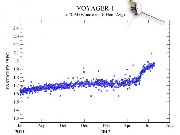
The last time such a jump in levels occurred was in May — and that spike took a week to happen.

“The increase and the decrease are sharper than we’ve seen before, but that’s also what we said about the May data,” said Edward Stone, the Voyager project scientist based at the California Institute of Technology. “The data are changing in ways that we didn’t expect, but Voyager has always surprised us with new discoveries.”

The graph below shows the jump in cosmic particles detected starting May 2012.

Over 11 billion miles (18 billion km) from home, Voyager 1 has been cruising through space since its launch on September 5, 1977. Its twin, Voyager 2, was launched two weeks earlier and is currently 9.3 billion miles (15 billion km) away. Both spacecraft are healthy and continue to communicate with Earth, and will both eventually break through the borders of our solar system and enter true interstellar space. If they are still operational when that happens — and there’s no reason that they shouldn’t be — we will finally get a sense of what conditions are like “out there”.

Although Voyager 1 is registering intriguing fluctuations in radiation from both inside and outside the Solar System, it’s not quite there yet.

“Our two veteran Voyager spacecraft are hale and healthy as they near the 35th anniversary of their launch,” said Suzanne Dodd, Voyager project manager based at JPL in Pasadena. “We know they will cross into interstellar space. It’s just a question of when.”

Read more about Voyager’s ongoing breakout here.

“We are certainly in a new region at the edge of the solar system where things are changing rapidly. But we are not yet able to say that Voyager 1 has entered interstellar space.”

–  Edward Stone, Voyager project scientist, Caltech

Images: NASA/JPL-Caltech

Curiosity Beams 1st Color Image from Mars

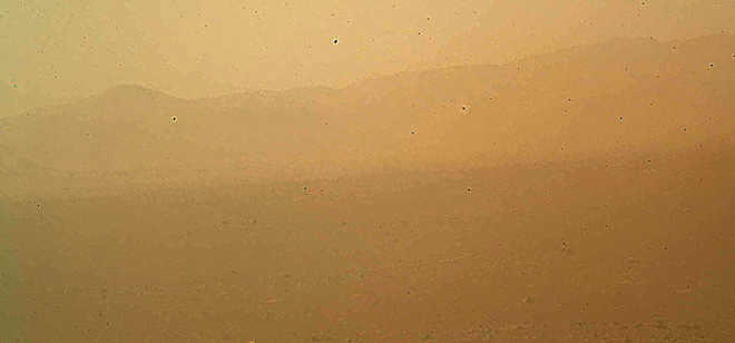
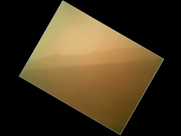
Image caption: This murky view from Curiosity shows the martian landscape looking north to the rim from inside the Gale Crater landing site and is her first color image beamed back to Earth. It’s murky because the dust cover is still attached. See full MAHLI image below. Also see below full res Hazcam image of crater rim. Credit: NASA/JPL-Caltech/Malin Space Science Systems

NASA’s Curiosity Mars rover has beamed back her first color view since touchdown, showing a view of the alien landscape pointing northward towards the eroded rim of Gale crater.

The picture was snapped by the rovers Mars Hand Lens Imager (MAHLI) camera on the afternoon of the first day after the pinpoint landing – signified as Sol 1 on Aug. 6, 2012.

The MAHLI image looks murky because the protective dust cover is still in place and is coated with a film of martian dust sprayed up by the descent retrorockets during the terminal phase of the hair-raising landing on Aug 5/6.

The camera’s dust cover is intentionally transparent so that initial images can still be snapped through the cover before it’s popped off in about a week.

MAHLI is located on the turret at the end of the rover’s 8 foot long robot arm which has been stowed in place on the front left side of Curiosity since long before the Nov. 26 liftoff from Cape Canaveral, Florida.

In the stowed position, MAHLI is rotated about 30 degrees as seen in the image below. The top image has been rotated to correct for the tilt and shows the sky “up” as Curiosity is actually sitting on the Martian surface.


Image caption: This full frame view from Curiosity shows the martian landscape looking north to the rim from inside the Gale Crater landing site and is her first color image beamed back to Earth. It’s murky because the dust cover is still attached. The image is from the MAHLI camera on the robot arm and currently in the stowed position. It has been rotated 30 degress. Credit: NASA/JPL-Caltech/Malin Space Science Systems

During her 2 year prime mission, Curiosity’s goal is to determine if Mars was ever capable of supporting microbial life, past or present and to search for the signs of life in the form of organic molecules with a payload of 10 science instruments weighing 15 times more than any prior roving vehicle.

Curiosity is the 3rd generation of NASA rover’s delivered to the Red Planet

Ken Kremer

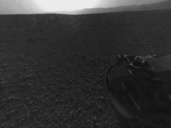
Image Caption: Looking Back at the Crater Rim – This is the full-resolution version of one of the first images taken by a rear Hazard-Avoidance camera on NASA’s Curiosity rover, which landed on Mars the evening of Aug. 5 PDT (morning of Aug. 6 EDT). The image was originally taken through the “fisheye” wide-angle lens, but has been “linearized” so that the horizon looks flat rather than curved. The image has also been cropped. A Hazard-avoidance camera on the rear-left side of Curiosity obtained this image. Part of the rim of Gale Crater, which is a feature the size of Connecticut and Rhode Island combined, stretches from the top middle to the top right of the image. One of the rover’s 20 inch wide wheels can be seen at bottom right. Image credit: NASA/JPL-Caltech

Curiosity’s Dramatic MARDI Descent Movie

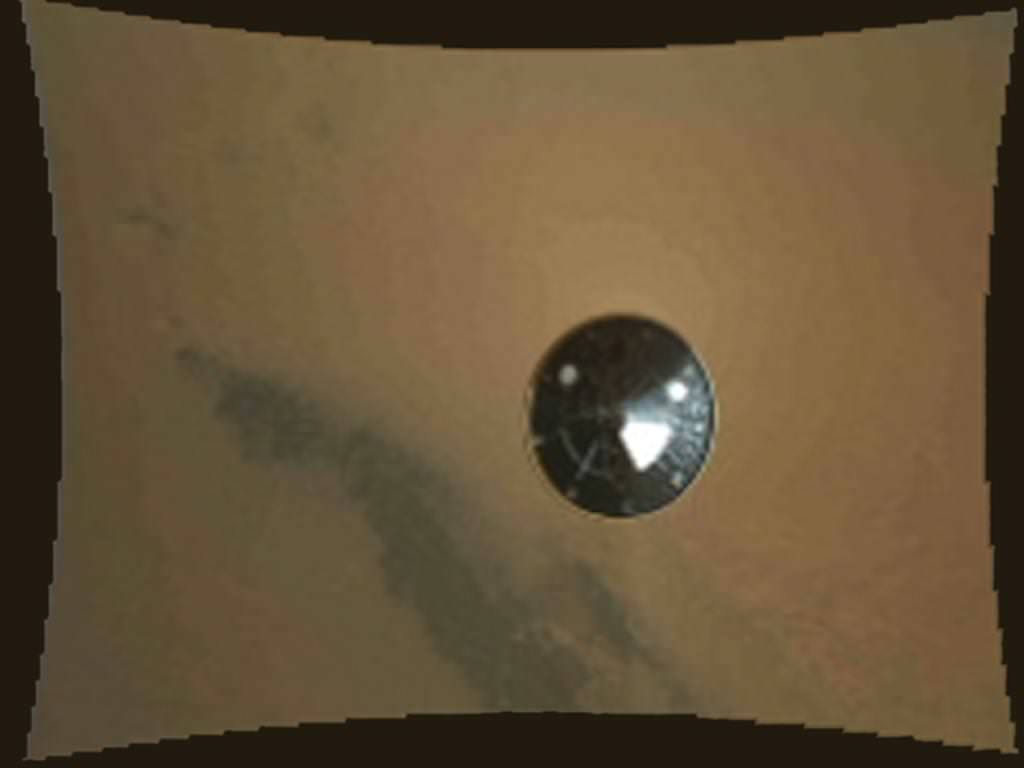
Image Caption: Curiosity Heat shield falls away from the bottom of Curiosity and the Sky Crane descent stage in this image from the MARDI camera.
Watch the video below. Credit: NASA/JPL/MSSS

As NASA’s Curiosity Mars Science Lab (MSL) was in the final stages of her flawless but harrowing decent to Gale Crater on Mars overnight (Aug. 5/6) employing the never-before-used rocket powered sky crane descent stage, dramatic movie-like imagery of the plunge was being recorded by MARDI, the Mars Descent Imager camera positioned on the belly of the rover and pointed downwards.

The first low resolution MARDI images and video (above and below) were beamed back to Earth just hours after landing and clearly show the jettisoning of the heat shield moments after it sprung loose to expose Curiosity and MARDI for landing.

“We see the heat shield falling away about 2 minutes and 30 seconds from touchdown,” said Mike Malin, MARDI Principal Investigator from Malin Space Systems at a post-landing news briefing today (Aug. 6). “The heat shield is about 16 meters (50 ft) away in the image and 4.5 m (15 ft) across.”

“I’m very excited to be at Gale Crater”.

“So far we have received about 297 thumbnail images (192 x 144 pixels) so far and created a stop motion video. MADRI was collecting images at 4 frames per second. In the final frames you can see dust being kicked up the rocket engines.”
Curiosity landed at 1:32 on Aug. 6, EDT (11:32 p.m. Aug. 5, PDT), near the foot of a mountain three miles(5 km) tall inside Gale Crater, 96 miles (154 km) in diameter.

Video Caption: The Curiosity Mars Descent Imager (MARDI) captured the rover’s descent to the surface of the Red Planet. The instrument shot 4 fps video from heatshield separation to the ground. Credit: NASA/JPL/MSSS

“The image sequence received so far indicates Curiosity had, as expected, a very exciting ride to the surface,” said Mike Malin, imaging scientist for the Mars Science Lab mission from Malin Space Systems in San Diego. “But as dramatic as they are, there is real other-world importance to obtaining them. These images will help the mission scientists interpret the rover’s surroundings, the rover drivers in planning for future drives across the surface, as well as assist engineers in their design of forthcoming landing systems for Mars or other worlds.”

“A good comparison is to that grainy onboard film from Apollo 11 when they were about to land on the moon,” said Malin.

Over 1500 hundred more low and high resolution MARDI images (1600 x 1200 pixels) will be sent back over the next few weeks to make a full frame animation and will provide the most complete and dramatic imagery of a planetary landing in the history of exploration.

The team has been able to determine Curiosity’s location to “within” about 1 meter says Malin, by matching the MARDI and MRO HiRISE images as well as the Hazcam images.

“So far the rover is healthy and we are ecstatic with its performance,” said Jennifer Trospher, MSL mission manager

The next steps are to deploy the high gain antenna (HGA), raise the mast with the higher resolution cameras and continue to check out the mechanical and electrical systems as well the science instruments as the rover is transitioned to surface operations mode.

Ken Kremer

President Obama Hails NASA Curiosity rover landing on Mars

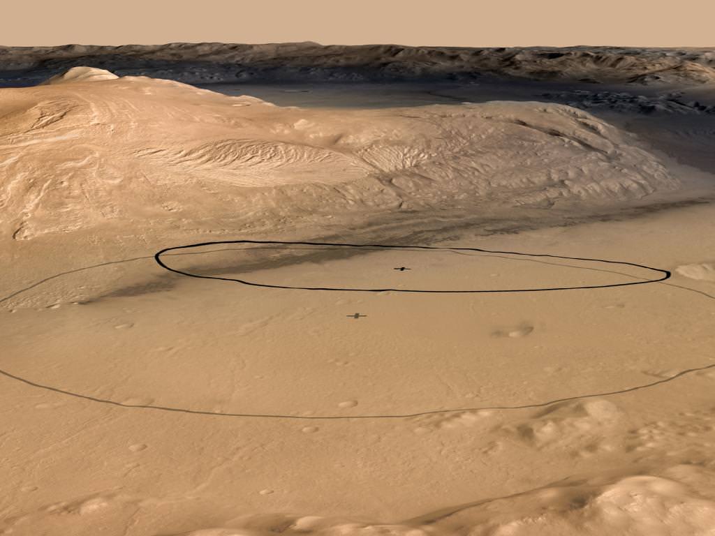
Image Caption: Landing ellipse for Curiosity rover inside Gale Crater at the foot of Mount Sharp on Mars and will attempt to climb the mountain later in the mission. Credit: NASA

US President Barack Obama hailed the spectacular landing success of NASA’s Curiosity rover on Aug. 6 inside Gale Crater and eagerly awaits the discoveries to come. More accolades for Curiosity and the rover team are pouring in from all across the globe.

The White House issued the following statement:

Statement by the President on Curiosity Landing on Mars

“Tonight, on the planet Mars, the United States of America made history.

The successful landing of Curiosity – the most sophisticated roving laboratory ever to land on another planet – marks an unprecedented feat of technology that will stand as a point of national pride far into the future. It proves that even the longest of odds are no match for our unique blend of ingenuity and determination.

Tonight’s success, delivered by NASA, parallels our major steps forward towards a vision for a new partnership with American companies to send American astronauts into space on American spacecraft. That partnership will save taxpayer dollars while allowing NASA to do what it has always done best – push the very boundaries of human knowledge. And tonight’s success reminds us that our preeminence – not just in space, but here on Earth – depends on continuing to invest wisely in the innovation, technology, and basic research that has always made our economy the envy of the world.

I congratulate and thank all the men and women of NASA who made this remarkable accomplishment a reality – and I eagerly await what Curiosity has yet to discover.”

The 1 ton Mini Cooper sized robot geologist and roving chemistry lab is seeking the signs of life on Mars and is loaded with 165 pounds of the most sophisticated science instruments ever delivered to the surface of the Red Planet.

During a two-year prime mission, Curiosity the rover will investigate whether the region has ever offered conditions favorable for microbial life, and search for organic molecules – the chemical ingredients for life.

Ken Kremer

Super Bowl of Planetary Exploration – Great Convergence of Spacecraft for Curiosity Mars Landing

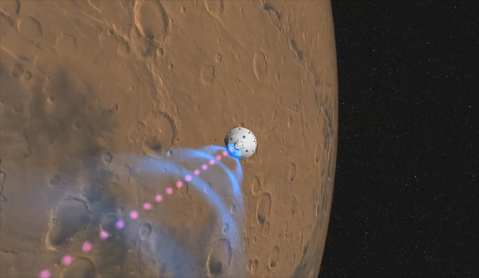
Image caption: This artist’s still shows how NASA’s Curiosity rover will communicate with Earth during landing. As the rover descends to the surface of Mars, it will send out two different types of data: basic radio-frequency tones that go directly to Earth (pink dashes) and more complex UHF radio data (blue circles) that require relaying by orbiters. NASA’s Odyssey orbiter will pick up the UHF signal and relay it immediately back to Earth, while NASA’s Mars Reconnaissance Orbiter will record the UHF data and play it back to Earth at a later time. Image credit: NASA/JPL-Caltech

Curiosity is just hours away from ‘do or die’ time and the high stakes and harrowing “7 Minutes of Terror” after an 8 month journey to touchdown on the Red Planet and potentially make historic discoveries that could ultimately answer the question ‘Are We Alone?’

An armada of spacecraft are converging at Mars for the historic landing of NASA’s Curiosity Mars Science Lab rover, the most daring, daunting and complex robotic mission that NASA has ever attempted. See the Video below

“Tonight is the Super Bowl of Planetary Exploration,” said Doug McCuistion, director of the Mars Exploration Program at NASA Headquarters, at a NASA JPL news briefing on Sunday (Aug. 5). “One yard line, one play left. We score and win, or we don’t score and we don’t win.”

“We are about to land a rover that is 10 times heavier and with 15 times the payload [compared to earlier rovers]. No matter what happens, I just want the team to know I am incredible proud and privileged to have worked with these guys and gals.”

“This is the most challenging landing we have ever attempted.”

“Mars Odyssey and Mars Reconnaissance Orbiter (MRO) are in good shape to relay the entry, descent and landing data.”

The trajectory to the atmospheric aim point is so precise that engineers decided to cancel the last course correction maneuver firing planned for today.

Tonight at around 1 AM EDT, Curiosity smashes into the Martian atmosphere at over 13,200 MPH (5,900 m/s) leading to an unprecedented entry, descent and landing sequence culminating in the never before tried “skycrane maneuver” and touchdown at 0 MPH just 7 minutes later astride a 3 mile (5 km ) mountain inside Gale Crater. Mount Sharp represents perhaps millions to perhaps billions of years of Mars geologic history stretching from the ancient wetter time to the more recent desiccated era.

“The team and the spacecraft are ready,” said Adam Steltzner, MSL Entry, Descent and Landing Lead engineer JPL. “We did everything possible to deserve success tonight, although as we all know we can never guarantee success. I am rationally confident and emotionally terrified and ready for EDL.”

Video Caption:This artist’s animation shows how orbiters over Mars will monitor the landing of NASA’s Curiosity rover.The animation starts with the path of NASA’s Mars Science Laboratory spacecraft capsule — which has the Curiosity rover tucked inside — speeding towards its Martian landing site in Gale Crater. Then, the paths of NASA’s Mars Odyssey orbiter and Mars Reconnaissance Orbiter become visible. Curiosity will be sending some basic radio-frequency tones straight back to Earth during its entry, descent and landing, on Aug. 5 PDT (Aug. 6 EDT). But sending more detailed engineering data about the landing is more complicated. Those kinds of data will be sent by Curiosity to the orbiters Odyssey and MRO, which will then relay them back to NASA’s Deep Space Network antennas on Earth. Curiosity can only send the data to Odyssey and MRO when it can see the orbiters — as soon as they rise above and before they set below the Martian horizon. Image Credit: NASA/JPL-Caltech

The 6 wheeled SUV sized rover Curiosity is scheduled to touchdown inside Gale Crater at about 1:31 a.m. EDT (531 GMT) early on Aug. 6 (10:31 p.m. PDT on Aug. 5).

Under the best circumstance, the first signals from the surface could be transmitted via Odyssey within a few minutes of touchdown.

Curiosity is a robotic geologist and a roving chemistry lab with 10 state-of-the-art science instruments that will collect and analyze soil and rock samples and zap rocks from a distance with a laser to search for carbon in the form of organic molecules – the building blocks of life.

“We will attempt to have the MRO HiRISE camera point at MSL and get an image of it the final phases of its descent going down to Mars,” said McCuistion. “This will be difficult because of all the gyrations by the spacecraft. It’s pretty challenging. It will be very tough. We were lucky to get one of Phoenix. I am hopeful”

“We have the opportunity for untold discoveries. We couldn’t even imagine going to this place on Mars a few years ago.”

“If we are successful, it will be one of the greatest feats in exploration ever!”

Watch NASA TV online for live coverage of the Curiosity landing on Aug. 5/6 starting at 11:30 pm EDT:

www.mars.jpl.nasa.gov or www.nasa.gov

Ken Kremer